Embed Size (px)
Citation preview
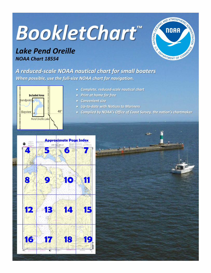
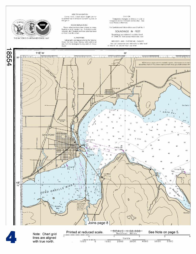
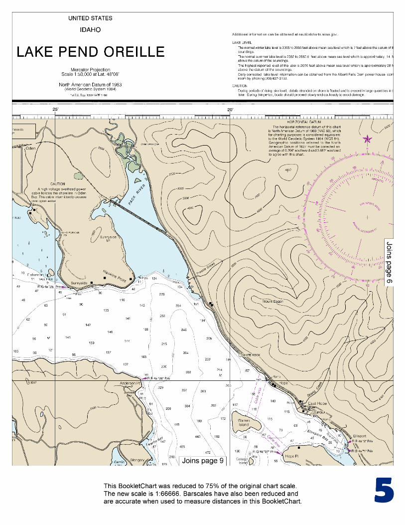
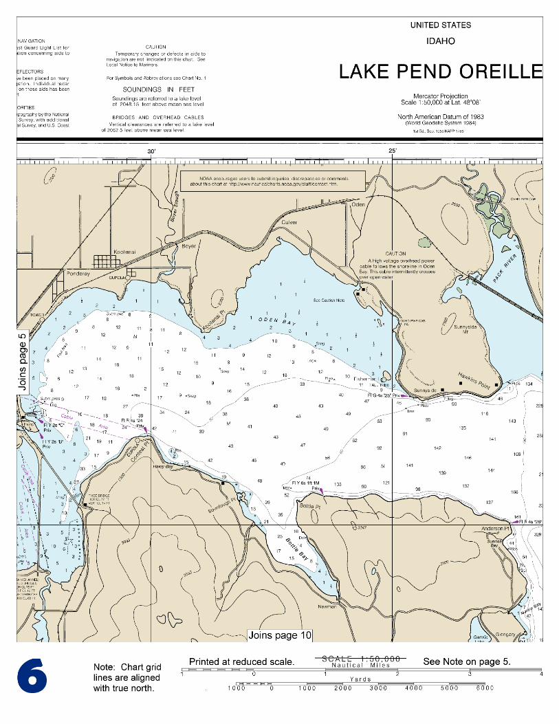
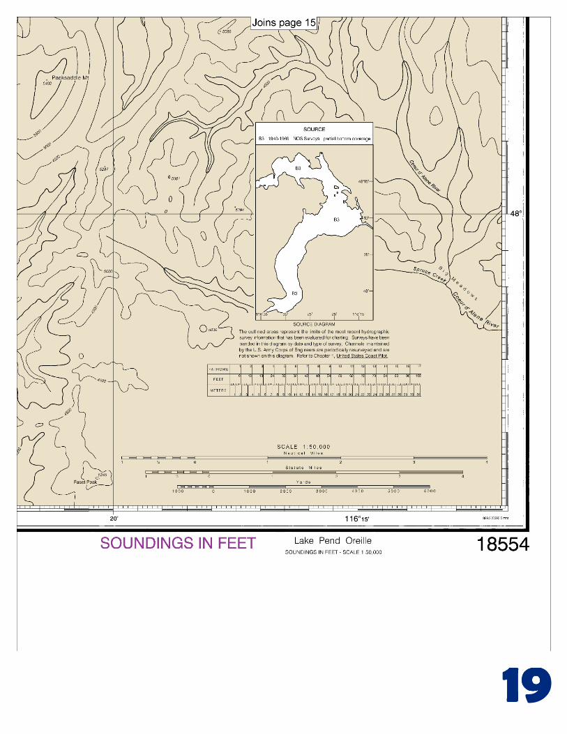
BookletChart™ Lake Pend Oreille NOAA Chart 18554
A reduced-scale NOAA nautical chart for small boaters When possible, use the full-size NOAA chart for navigation.
Included Area

2
Published by the National Oceanic and Atmospheric Administration
National Ocean Service Office of Coast Survey
www.NauticalCharts.NOAA.gov 888-990-NOAA
What are Nautical Charts?
Nautical charts are a fundamental tool of marine navigation. They show water depths, obstructions, buoys, other aids to navigation, and much more. The information is shown in a way that promotes safe and efficient navigation. Chart carriage is mandatory on the commercial ships that carry America’s commerce. They are also used on every Navy and Coast Guard ship, fishing and passenger vessels, and are widely carried by recreational boaters.
What is a BookletChart?
This BookletChart is made to help recreational boaters locate themselves on the water. It has been reduced in scale for convenience, but otherwise contains all the information of the full-scale nautical chart. The bar scales have also been reduced, and are accurate when used to measure distances in this BookletChart. See the Note at the bottom of page 5 for the reduction in scale applied to this chart.
Whenever possible, use the official, full scale NOAA nautical chart for navigation. Nautical chart sales agents are listed on the Internet at http://www.NauticalCharts.NOAA.gov.
This BookletChart does NOT fulfill chart carriage requirements for regulated commercial vessels under Titles 33 and 44 of the Code of Federal Regulations.
Notice to Mariners Correction Status
This BookletChart has been updated for chart corrections published in the U.S. Coast Guard Local Notice to Mariners, the National Geospatial Intelligence Agency Weekly Notice to Mariners, and, where applicable, the Canadian Coast Guard Notice to Mariners. Additional chart corrections have been made by NOAA in advance of their publication in a Notice to Mariners. The last Notices to Mariners applied to this chart are listed in the Note at the bottom of page 7. Coast Pilot excerpts are not being corrected.
For latest Coast Pilot excerpt visit the Office of Coast Survey website at http://www.nauticalcharts.noaa.gov/nsd/searchbychart.php?chart=18554.
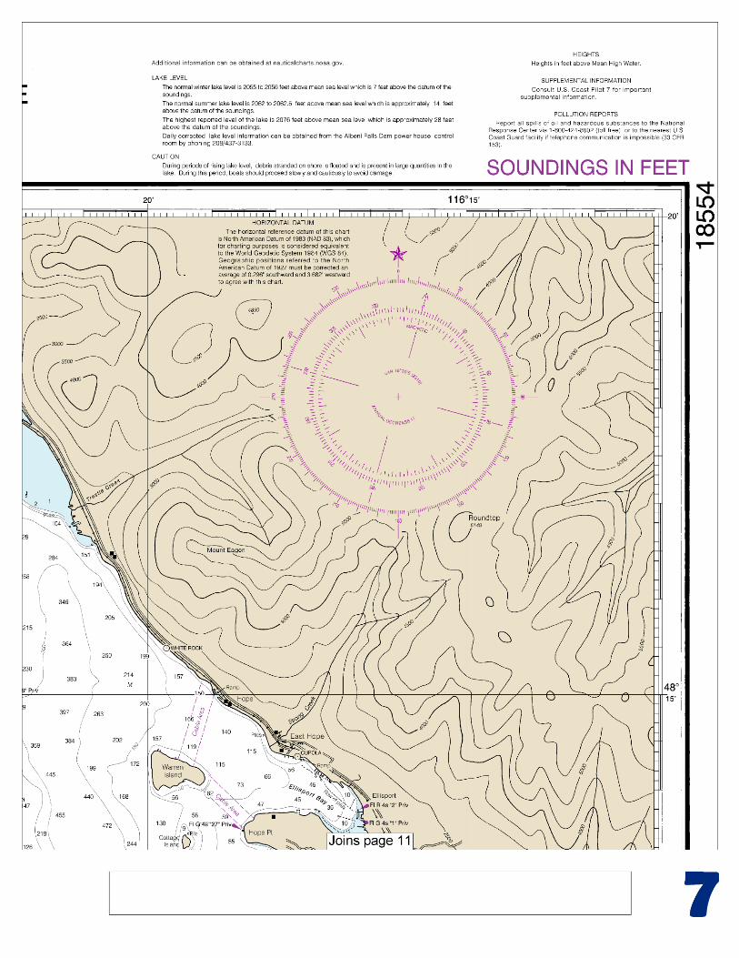
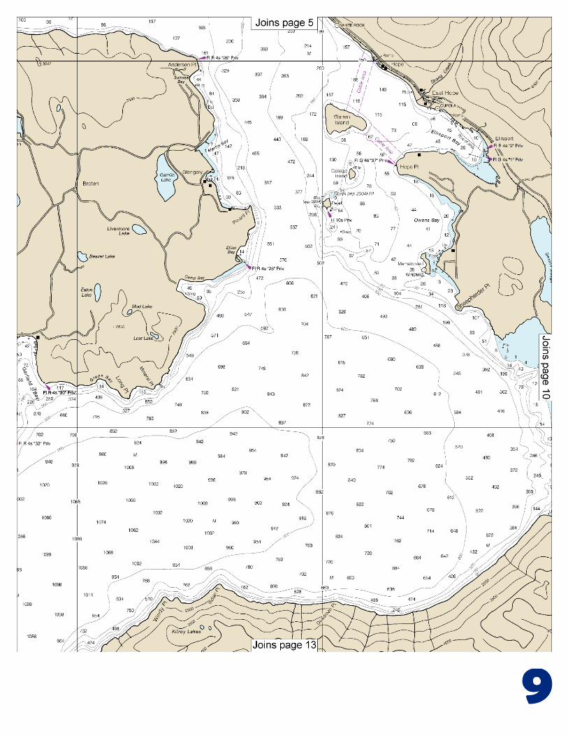
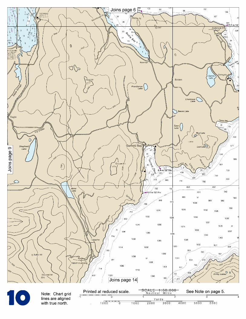
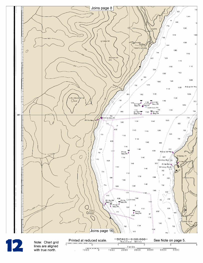
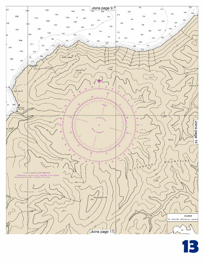
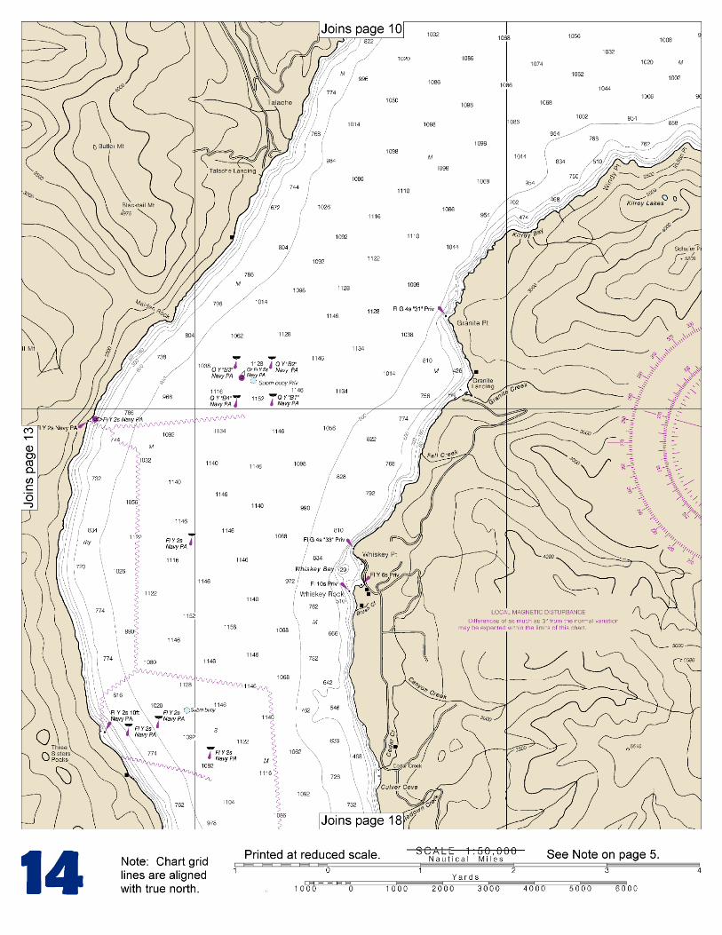
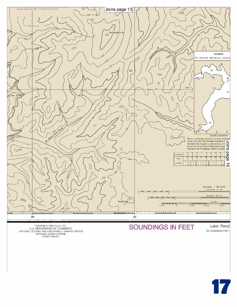
(Selected Excerpts from Coast Pilot) Lake Pend Oreille (48°10'N., 116°25'W.), Idaho, is a recreation area nearly surrounded by the Kaniksu National Forest. The charted depths are based on a lake level of 2048.15 feet above mean sea level. Normal winter and summer lake levels are about 3 feet and 14 feet above the charted depths, respectively. Lake level information, corrected daily, can be obtained by calling the U.S. Army Corps of Engineers, Albeni Falls Dam, telephone (208–437–3133).
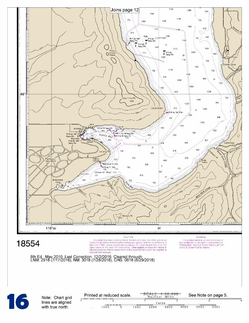
Marina services at Sandpoint, on the N side of the Pend Oreille River at its junction with Lake Pend Oreille, include berthing, gasoline, a
launching ramp, winter storage, and hull and engine repairs. The drawspan of the railroad bridge across the Pend Oreille River, at the river and lake junction, is in the permanently closed position. (See 117.1 through 117.59 and 117.383, chapter 2, for drawbridge regulations.) U.S. Route 95 fixed highway bridge crosses the river just above the railroad bridge; the least clearance for both bridges is 14 feet. At Bayview (47°59'N., 116°34'W.), at the SW end of the lake just W of Scenic Bay, has several marinas that can provide transient berthing, gasoline, diesel fuel, launching ramps, winter storage, marine supplies, water, and pump-out stations; complete marine services are available. Additional information about facilities and services may be obtained from the Sandpoint Chamber of Commerce, Sandpoint, ID 83864. This chapter describes the Pacific coast of the State of Washington from the Washington-Oregon border at the mouth of the Columbia River to the northwesternmost point at Cape Flattery. The deep-draft ports of South Bend and Raymond, in Willapa Bay, and the deep-draft ports of Hoquiam and Aberdeen, in Grays Harbor, are described. In addition, the fishing port of La Push is described. The most outlying dangers are Destruction Island and Umatilla Reef. A U.S. Navy operating/exercise area parallels the coastline from about 10 miles N of Point Brown to Cape Alava, extending from 3 miles offshore to about 50 miles offshore. The Olympic Coast National Marine Sanctuary, off the Olympic Peninsula of Washington State, including the waters of the Strait of Juan de Fuca, extends from Koitlah Point due north to the international boundary seaward to the 100 fathom isobath, thence southward to a point due west of the mouth of the Copalis River cutting across the heads of Nitnat, Juan de Fuca, and Quinault Canyons. (See 15 CFR 922, chapter 2, for limits and regulations.) Area to be Avoided-Washington Coast.–The International Maritime Organization (IMO) has adopted the waters off the Washington Coast as an area to be avoided. In order to avoid risk of pollution in the area designated as the Olympic Coast National Marine Sanctuary (OCNMS), all vessels carrying oil or other hazardous materials and vessels 1,600 gross tons or more, engaged solely in transit, should avoid the area bounded by a line connecting the following points:
48°23.30'N., 124°38.20'W. 48°24.17'N., 124°38.20'W. 48°26.15'N., 124°44.65'W. 48°26.15'N., 124°52.80'W. 48°24.67'N., 124°55.71'W. 47°51.70'N., 125°15.50'W. 47°07.70'N., 124°47.50'W. 47°07.70'N., 124°11.00'W.
COLREGS Demarcation Lines.–The lines established for this part of the coast are described in 80.1370 through 80.1380, chapter 2.
U.S. Coast Guard Rescue Coordination Center 24 hour Regional Contact for Emergencies
RCC Seattle Commander
13th CG District (206) 220-7001 Seattle, WA
G
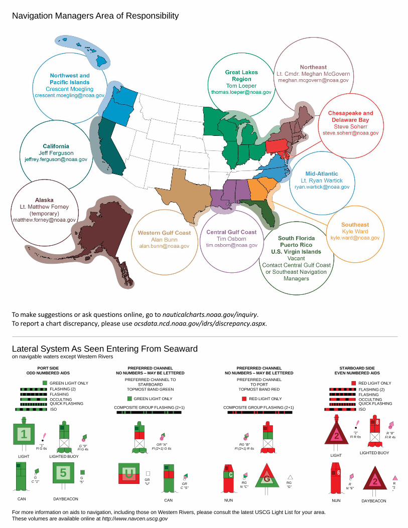
NOAA’s navigation managers serve as ambassadors to the maritime community. They help identify navigational challenges facing professional and recreational mariners, and provide NOAA resources and information for safe navigation. For additional information, please visit nauticalcharts.noaa.gov/service/navmanagers
To make suggestions or ask questions online, go to nauticalcharts.noaa.gov/inquiry. To report a chart discrepancy, please use ocsdata.ncd.noaa.gov/idrs/discrepancy.aspx.
Lateral System As Seen Entering From Seaward on navigable waters except Western Rivers
PORT SIDE
ODD NUMBERED AIDS
GREEN LIGHT ONLY
FLASHING (2)
PREFERRED CHANNEL
NO NUMBERS – MAY BE LETTERED
PREFERRED CHANNEL TO
STARBOARD
TOPMOST BAND GREEN
PREFERRED CHANNEL
NO NUMBERS – MAY BE LETTERED
PREFERRED CHANNEL
TO PORT
TOPMOST BAND RED
STARBOARD SIDE
EVEN NUMBERED AIDS
RED LIGHT ONLY
FLASHING (2)
FLASHING FLASHING
OCCULTING GREEN LIGHT ONLY RED LIGHT ONLY OCCULTING QUICK FLASHING QUICK FLASHING
ISO COMPOSITE GROUP FLASHING (2+1) COMPOSITE GROUP FLASHING (2+1) ISO
"1"
Fl G 6s
G "9"
Fl G 4s
GR "A"
Fl (2+1) G 6s
RG "B"
Fl (2+1) R 6s
"2"
Fl R 6s
8
R "8"
Fl R 4s
LIGHT
G
C "1"
LIGHTED BUOY
G
"5"
GR
"U"
GR
C "S"
RG
N "C"
RG
"G"
LIGHT
6
R
N "6"
LIGHTED BUOY
R
"2
"
CAN DAYBEACON
CAN NUN NUN
DAYBEACON
For more information on aids to navigation, including those on Western Rivers, please consult the latest USCG Light List for your area.
These volumes are available online at http://www.navcen.uscg.gov
Navigation Managers Area of Responsibility
Northeast
Lt. Meghan McGovern
Northwest and
Pacific Islands
Crescent Moegling
Great Lakes Region
Tom Loeper
Chesapeake and
Delaware Bay
Steve Soherr
California
Jeff Ferguson
[email protected] Mid-Atlantic
Lt. Ryan Wartick
Alaska
Lt. Timothy M. Smith
Western Gulf Coast
Alan Bunn
Central Gulf Coast
Tim Osborn
[email protected] South Florida
Puerto Rico
U.S. Virgin Islands
Michael Henderson
Southeast
Kyle Ward
2
2 C U 5
1


VHF Marine Radio channels for use on the waterways:Channel 6 – Inter-ship safety communications.Channel 9 – Communications between boats and ship-to-coast.Channel 13 – Navigation purposes at bridges, locks, and harbors.Channel 16 – Emergency, distress and safety calls to Coast Guard and others, and to initiate calls to other
vessels. Contact the other vessel, agree to another channel, and then switch.Channel 22A – Calls between the Coast Guard and the public. Severe weather warnings, hazards to navigation and safety warnings are broadcast here.Channels 68, 69, 71, 72 and 78A – Recreational boat channels.
Getting and Giving Help — Signal other boaters using visual distress signals (flares, orange flag, lights, arm signals); whistles; horns; and on your VHF radio. You are required by law to help boaters in trouble. Respond to distress signals, but do not endanger yourself.
EMERGENCY INFORMATION
Distress Call Procedures
• Make sure radio is on.• Select Channel 16.• Press/Hold the transmit button.• Clearly say: “MAYDAY, MAYDAY, MAYDAY.”• Also give: Vessel Name and/or Description;Position and/or Location; Nature of Emergency; Number of People on Board.• Release transmit button.• Wait for 10 seconds — If no responseRepeat MAYDAY call.
HAVE ALL PERSONS PUT ON LIFE JACKETS!
This Booklet chart has been designed for duplex printing (printed on front and back of one sheet). If a duplex option is not available on your printer, you may print each sheet and arrange them back-to-back to allow for the proper layout when viewing.
QR
Quick ReferencesNautical chart related products and information - http://www.nauticalcharts.noaa.gov
Interactive chart catalog - http://www.charts.noaa.gov/InteractiveCatalog/nrnc.shtmlReport a chart discrepancy - http://ocsdata.ncd.noaa.gov/idrs/discrepancy.aspx
Chart and chart related inquiries and comments - http://ocsdata.ncd.noaa.gov/idrs/inquiry.aspx?frompage=ContactUs
Chart updates (LNM and NM corrections) - http://www.nauticalcharts.noaa.gov/mcd/updates/LNM_NM.html
Coast Pilot online - http://www.nauticalcharts.noaa.gov/nsd/cpdownload.htm
Tides and Currents - http://tidesandcurrents.noaa.gov
Marine Forecasts - http://www.nws.noaa.gov/om/marine/home.htm
National Data Buoy Center - http://www.ndbc.noaa.gov/
NowCoast web portal for coastal conditions - http://www.nowcoast.noaa.gov/
National Weather Service - http://www.weather.gov/
National Hurrican Center - http://www.nhc.noaa.gov/
Pacific Tsunami Warning Center - http://ptwc.weather.gov/
Contact Us - http://www.nauticalcharts.noaa.gov/staff/contact.htm
NOAA’s Office of Coast Survey The Nation’s Chartmaker
For the latest news from Coast Survey, follow @NOAAcharts
NOAA Weather Radio All Hazards (NWR) is a nationwide network of radio stations broadcasting continuous weather information directly from the nearest National Weather Service office. NWR broadcasts official Weather Service warnings, watches, forecasts and other hazard information 24 hours a day, 7 days a week. http://www.nws.noaa.gov/nwr/