Embed Size (px)
Citation preview
Palaeogeography, Palaeoclimatology, Palaeoecology, 95 (1992): 19-32 19 Elsevier Science Publishers B.V., Amsterdam
Lake-size variations in the Lahontan and Bonneville basins between 13,000 and 9000 14C yr B.P.
L a r r y Benson a, D o n a l d C u r r e y b, Y o n g L a o c and Steve H o s t e t l e r a
• u.s. Geological Survey, M.S. 458, Boulder Laboratory, Federal Center, Denver, CO 80225 USA bGeography Department, University of Utah, Salt Lake City, Utah 84112, USA
C Lamont-Doherty Geological Observatory, Columbia University, Palisades, N Y 10964. USA
(Received November 27, i 991; revised and accepted February 10, 1992)
ABSTRACT
Benson, L., Currey, D., Yong Lao and Hostetler, S., 1992. Lake-size variations in the Lahontan and Bonneville basins between 13,000 and 9000 14C yr B.P.. Palaeogeogr., Palaeoclimatol., Palaeoecol., 95: 19-32.
Recessions of Lakes Lahontan and Bonneville that commenced ~ 13,500 ~4C yr B.P. were interrupted at i> 11,500 14C yr B.P. in the Lahontan basin and ~ 12,200 14C yr B.P. in the Bonneville basin by relatively large perturbations in lake level that persisted for ~ 2000 years. Minor glacial readvances in the Sierra Nevada and White Mountains of California-Nevada occurred during the latter half of this interval (between I 1,000 and 9700 14C yr B.P.). The hydrologic response of Lakes Lahontan and Bonneville and the mountain glacial advances were concurrent with the Allerod/Younger Dryas climatic intervals recorded in vegetational and glacial records of western and central Europe.
Introduction
Between 13,000 and 10,000 1'C yr B.P., Europe south of the Weichselian ice sheet experienced major changes in climate. Based primarily on vegetational change, this period has been subdi- vided into three intervals: Bailing (13,000-12,000 14C yr B.P.), Allerod (12,000-11,000 14C yr B.P.), and Younger Dryas (11,000-10,000 ~4C yr B.P.) (Mangerud et al., 1974). During the Allerod interval, Europe was the site of a transition from tundra to tree birch; but at the end of the Allerad interval, the inferred trend in climatic warming was reversed by a return to tundra condi t ions- - the Younger Dryas in terval - -which lasted about 1000 years (Wright, 1989).
During the last few years, a debate has developed over whether the Younger Dryas event was con- fined to the periphery of the North Atlantic and
Correspondence to: L. Benson, U.S. Geological Survey, Water Resources Division US4, 325 Broadway, Boulder, CO 80303, USA.
the European continent or whether the event was global in scope. In North America, only sites adjacent to the North Atlantic indicate unequivo- cal evidence of a climatic perturbation between 11,000 and 10,000 14C yr B.P. (Livingstone and Livingstone, 1958; Anderson, 1983; Mott et al., 1984; Mott, 1985). Shane (1987, 1990) has docu- mented the recurrence of spruce (Picea) at 14 sites in the Till Plains of Indiana, Michigan, and Ohio which were interpreted as indicating a climatic cooling between 11,000 and 10,000 14C yr B.P.; however, whether this cooling was due to a global Younger Dryas event or to the discharge of cold glacial meltwater to lakes north of the Till Plains remains unresolved. Hence, the effect of the Youn- ger Dryas event on the climate of the North American continent west of the Atlantic border remains uncertain.
The overall objective of this paper is to present the record of lake-level change in the northern Great Basin for the 4500 yr that followed the highstands of Lakes Lahontan and Bonneville. In focusing on this period, we also present some
0031-0182/92/$05.00 © 1992 -- Elsevier Science Publishers B.V. All rights reserved.
20 L. BENSON ET AL.
evidence on the nature of climatic change that occurred in the western United States during the Bolling/Allerod/Younger Dryas intervals.
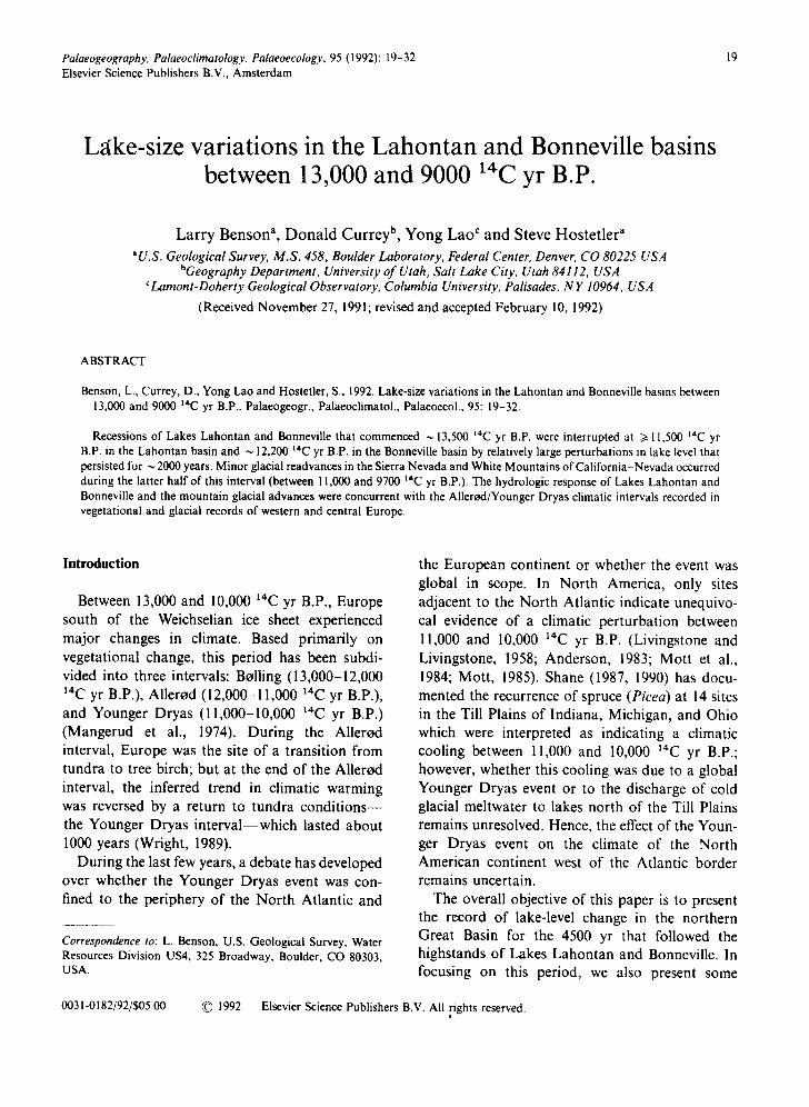
Lake Lahontan and Lake Bonneville (Fig. l) may have had nearly synchronous recessions com- mencing ~ 13,500 14C yr B.P. (Benson et al., 1990).
Until recently, however, not much was known about lake-size variation in the Lahontan and Bonneville basins subsequent to 13,000 14C yr B.P. In this paper, model chronologies of lake-level variation are presented for 13,000-9000 14C yr B.P. The chronologies are based on radiocarbon-
I
4 1 "
121 ° 1 1 9 ° 1 1 7 ° 1 1 5 ° 1 1 3 ° 111 ° I J I I I
I0
tON
C.
LA
4 3 °¸
.KE
3 9 °
37"
35.
D
N
VG i
/ v " i , . ~ ' S E , ~ R t ~ o c a r e
D
I i I I
0 100 200 I J J
Fig. 1. Principal Great Basin paleolak¢ systems of the late Quaternary.
4 0 0 K i l o m e t e r s J
M i l e s i
, e ImKqll~
I i
LAKE-SIZE VARIAI IONS IN THE LAHON'IAN AND BONNEVILLE BASINS 21
age estimations of tufas, shells, plants, and organic material associated with rock varnish. Most of the data on which the Lahontan chronology is based has not been published previously; and the data on which the Bonneville chronology is based has been previously published in journals and reports that may not be accessible to the interested reader.
Lake-level variation in the Lahontan basin between 13,000 and 9000 t4C yr B.P.
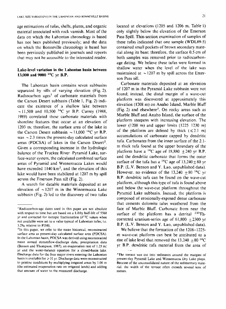
The Lahontan basin contains seven subbasins separated by sills of varying elevation (Fig. 2). Radiocarbon ages ~ of carbonate materials from the Carson Desert subbasin (Table 1, Fig. 2) indi- cate the existence of a shallow lake between
11,500 and 10,500 ~4C yr B.P. Currey (1988, 1989) correlated these carbonate materials with shoreline features that occur at an elevation of 1203 m; therefore, the surface area of the lake in the Carson Desert subbasin ,-, 11,000 ~*C yr B.P. was ~ 2.3 times the present-day calculated surface areas (PDCSA) of lakes in the Carson Desert 2. Given a corresponding increase in the hydrologic balance of the Truckee River-Pyramid Lake, sur- face-water system, the calculated combined surface areas of Pyramid and Winnemucca Lakes would have exceeded 1140 km 2, and the elevation of this lake would have been stabilized at 1207 m by spill across the Emerson Pass sill (Fig. 2).
A search for datable materials deposited at an elevation of ---1207 m in the Winnemucca Lake subbasin (Fig. 2) led to the discovery of two tufas
t Radiocarbon-age dates used in this paper are not absolute with respect to time but are based on a Libby half-life of 5568 yr and corrected for isotopic fractionation (3~3C values when not available were set to a value typical of Lahontan tufas; i.e. 3.2%0 relative to PDB). 2In this paper, we refer to the mean historical, reconstructed surface area as present-day calculated surface area (PDCSA). In the Lahontan basin, PDCSA was derived using reconstructed mean annual streamflow-discharge data, precipitation data (Benson and Thompson , 1987), an evaporation rate of 1.25 m/ yr and the water-balance equation for a closed-basin lake. Discharge data for the four major rivers entering the Lahontan basin is available for > 31 yr. Discharge data were reconstructed to pristine conditions by multiplying irrigated areas by 1.00 m (the estimated evaporation rate on irrigated lands) and adding that amount of water to the measured discharge.
located at elevations (1205 and 1206 m, Table 1) only slightly below the elevation of the Emerson Pass Spill. Thin-section examination of samples of these tufas indicated that one sample (WDL89-5) contained small pockets of brown secondary mate- rial along its base; therefore, the surface 0.5 cm of both samples was removed prior to radiocarbon- age dating. We believe these tufas were formed in shallow water when the level of the lake was maintained at --- 1207 m by spill across the Emer- son Pass sill.
Carbonate materials deposited at an elevation of 1207 m in the Pyramid Lake subbasin were not found; instead, the distal margin of a wave-cut platform was discovered at approximately this elevation (1208 m) on Anaho Island, Marble Bluff (Fig. 2) and elsewhere 3. On rocky areas such as Marble Bluff and Anaho Island, the surface of the platform steepens with increasing elevation. The lower (1208 m) and upper limits (1225 1230 m) of the platform are defined by thick (~<2.1 m) accumulations of carbonate capped by dendritic tufa. Carbonates from the inner surface of the 2. I- m thick tufa found at the upper boundary of the platform have a 14C age of 18,880 +240 yr B.P. and the dendritic carbonate that tbrms the outer surface of the tufa has a 14C age of 13,240+80 yr B.P. (L.V. Benson and Y. Lao, unpublished data). However, no evidence of the 13,240 +_ 80 1"C yr B.P. dendritic tufa can be found on the wave-cut platform, although this type of tufa is found above and below the wave-cut platform throughout the Pyramid Lake subbasin. Instead, the platform is composed of erosionally-exposed dense carbonate that cements dolomite talus weathered from the face of Marble Bluff. Carbonate from near the surface of the platform has a detrital Z3°Th- corrected uranium-series age of 61,800 +2300 yr B.P. (L.V. Benson and Y. Lao, unpublished data).
We believe that the formation of the 1208-1225- m wave-cut platform can best be attributed to a rise of lake level that removed the 13,240 + 80 t4C yr B.P. dendritic tufa material from the area of
3The terrace was cut into sediments around the margins of present-day Pyramid Lake and Winnemucca Dry Lake playa. Because of the unconsolidated nature of the sedimentary mate- rial, the width of the terrace often exceeds several tens of meters.
22
1210 120 o
, 2 , I/CALIF6R--NI~ NE'VADA
119 a
41 •
I !
I I I BLACI I
BOUNDARY OF LAKE LAHE~TAN HIGHSTAND
. : . ' . .~ ' .~ ' : . ; ' :
118 • 117 °
I I , IDAHO I
L. BENSON ET AL.
118 •
40*
39*
TETONS /~AHO 18LAND
MARBLE BLUFF
. . : ~..:
!;-:
" P Y R A M I D L A K E ~ r . , . . : : . . . . . . , . , . . . ; .
..-.....
//~;
WALKER L ,M~
38* \
0 100 KILOMETERS I I I I I I I i I I I I
o 50 MILES J.
Fig. 2. Rivers, subbasins, sills, and sample localities in the Lahontan basin.
E X PLAN A T I O N ' ; : ' ! ~ " . : . . : ' . : . . .
i'. . R . PRIMARY SILLS ~ SECONDARY SILLS
PRESENT-DAY LAKES OR PLAYAS
~ LAND AREAS
PRIMARY SILLS (m) 1 Pronto (1292)
2 Chocolate (1262)
3 Adrian Valley (1308)
4 Darwin Pass (1265)
5 Mud Lake Slough (1177)
6 A s t o r P a s s (1222)
7 Emerson Pass (1207)
MAJOR SUBBASlNS I Smoke Creek/
Black Rock Desert
II Carson Desert III Buena V i s t a
IV Walker Lake V Pyramid Lake VI Winnemucca Dry Lake
VII Honey Lake
.L 1
the platform. A lake that is receding or held stable against a steeply inclined shoreland is capable of eroding only a narrow wave-cut platform (Stine, 1987). Stabilization in lake level might account for partial removal of carbonate that coated the distal margin of the platform when the level of the lake was constrained by spill across Emerson Pass sill,
but stabilization cannot account for removal of the carbonate from the wave-cut platform from above 1207 m. In addition, the outer surfaces of dendritic tufa from between 1330 and 1230 m are not eroded indicating that removal of tufa from this interval did not occur during recession of the lake from its highstand.
LAKE-SIZE VARIATIONS IN THE LAHONTAN AND BONNEVILLE BASINS
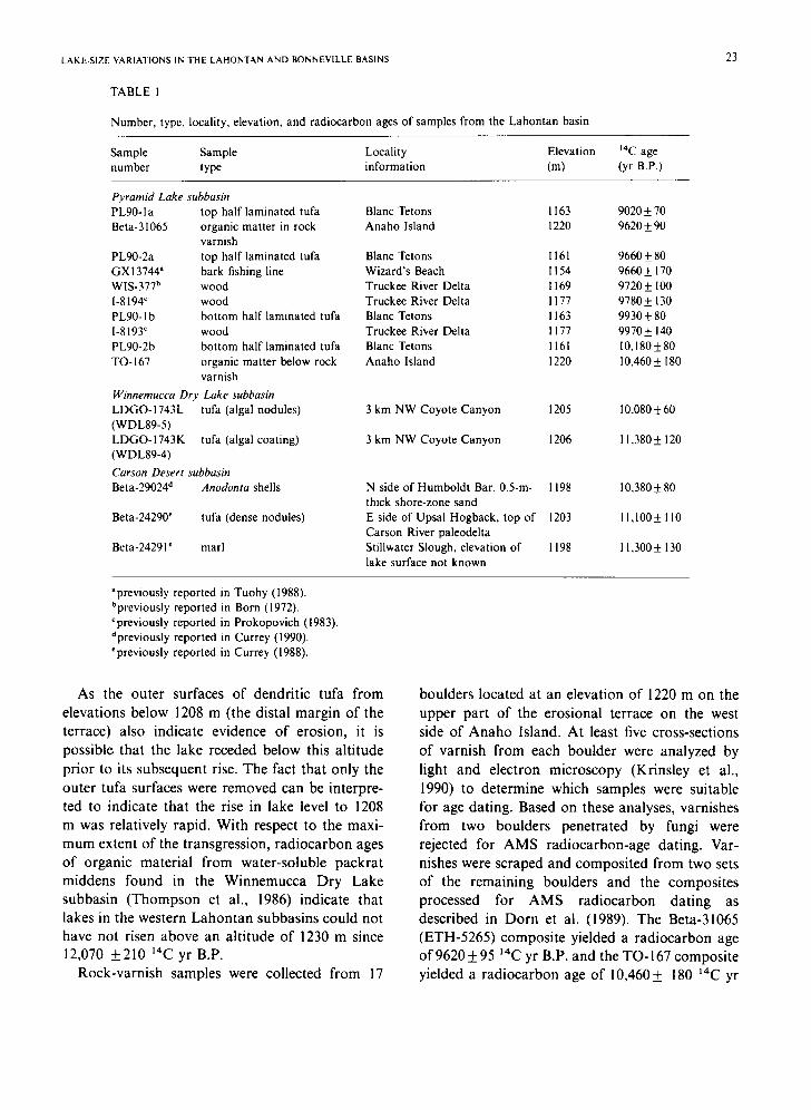
TABLE l
Number, type, locality, elevation, and radiocarbon ages of samples from the Labontan basin
23
Sample Sample Locality Elevation 14C age number type information (m) (yr B.P.)
Pyramid Lake subbasin PL90-1a top half laminated tufa Blanc Tetons Beta-31065 organic matter in rock Anaho Island
varnish PL90-2a top half laminated tufa Blanc Tetons GX13744 a bark fishing line Wizard's Beach WIS-377 h wood Truckee River Delta 1-8194' wood Truckee River Delta PL90- I b bottom half laminated tufa Blanc Tetons 1-8193' wood Truckee River Delta PL90-2b bottom half laminated tufa Blanc Tetons TO-167 organic matter below rock Anaho Island
varnish
Winnemucca Dry Lake subbasin LDGO-1743L tufa (algal nodules) (WDL89-5) LDGO-1743K tufa (algal coating) (WDL89-4)
Carson Desert subbasin Beta-29024 d Anodonta shells
Beta-24290 ' tufa (dense nodules)
Beta-24291' marl
1163 9020±70 1220 9620±90
161 9660 4- 80 154 9660± 170 169 97204- I00 177 9780± 130 163 99304- 80 177 9970± 140 161 [0,180±80
1220 10,460± 180
3 km NW Coyote Canyon 1205
3 km NW Coyote Canyon 1206
N side of Humboldt Bar, 0.5-m- 1198 thick shore-zone sand E side of Upsal Hogback, top of 1203 Carson River paleodelta Stillwater Slough, elevation of 1198 lake surface not known
10,080 + 60
11,380 4- 120
10,380 4- 80
11,100+ I10
11,300 4- 130
apreviously reported in Tuohy (1988). bpreviously reported in Born (1972). Cpreviously reported in Prokopovich (1983). dpreviously reported in Currey (1990). "previously reported in Currey (1988).
As the outer surfaces of dendritic tufa from elevations below 1208 m (the distal margin of the terrace) also indicate evidence of erosion, it is possible that the lake receded below this altitude prior to its subsequent rise. The fact that only the outer tufa surfaces were removed can be interpre- ted to indicate that the rise in lake level to 1208 m was relatively rapid. With respect to the maxi- mum extent of the transgression, radiocarbon ages of organic material from water-soluble packrat middens found in the Winnemucca Dry Lake subbasin (Thompson et al., 1986) indicate that lakes in the western Lahontan subbasins could not have not risen above an altitude of 1230 m since 12,070 4-210 14C yr B.P.
Rock-varnish samples were collected from 17
boulders located at an elevation of 1220 m on the upper part of the erosional terrace on the west side of Anaho Island. At least five cross-sections of varnish from each boulder were analyzed by light and electron microscopy (Krinsley et al., 1990) to determine which samples were suitable for age dating. Based on these analyses, varnishes from two boulders penetrated by fungi were rejected for AMS radiocarbon-age dating. Var- nishes were scraped and composited from two sets of the remaining boulders and the composites processed for AMS radiocarbon dating as described in Dorn et al. (1989). The Beta-31065 (ETH-5265) composite yielded a radiocarbon age of 9620+__95 14C yr B.P. and the TO-167 composite yielded a radiocarbon age of 10,460+ 180 ~4C yr
24 L. BENSON ET AL.
B.P. (Table 1). Examination of varnish cross- sections from one TO-167 boulder indicated the presence of abundant pockets of organic debris trapped in subvarnish cavities. Some of this organic material consists of pollen grains but most of the material is unidentifiable. Most of the organic matter extracted from TO-167 boulders may have come from subvarnish pockets and the 9% difference in the ages of the two varnish composites may, therefore, be due to differences in the locations of organic matter; i.e, the TO-167 sample contained organic matter that was depos- ited within the upper surface of the terrace /> 10,500 14C yr B.P. prior to accumulation of an amount of basal varnish organic matter sufficient for AMS ~4C age dating. Radiocarbon-age dates of organic material from basal varnish layers pro- vide a minimum surface exposure age for the underlying landform; i.e., the erosional terrace formerly occupied by the lake. Dorn et al. (1989) have demonstrated, that in desertic areas, basal varnish ~4C-age dates lag the true ages of landform exposure by ~< 10% 1. In a more precisely calibrated study, Dorn et al. (1989) have shown that radiocar- bon age dates of basal varnish layers formed on lava flows on the semi-arid side of Hualalai Vol- cano, Hawaii, lag radiocarbon age dates on char- coals formed during emplacement of the basaits by ~ 13%. In this paper, we will apply the 13% lag-time correction to the AMS 14C age date of Beta-31065 to estimate the maximum age of terrace exposure (10,850 ~4C yr B.P.). The uncorrected AMS 14C date of Beta-31065 provides an estimate of the minimum age of terrace exposure (9620 14C yr B.P.). Therefore, abandonment of the 1220-m shoreline is calculated to have occurred sometime between 10,850 and 9,600 14C yr B.P. If the TO- 167 composite accumulated in the upper surface of the erosional terrace soon after recession of the lake, the TO-167 age date (10,460 _ 180 14C yr
1The true ages of landform exposures used in Dorn et al. (1989) were obtained from 14C-age dates of carbon-bearing materials associated with the landform. In many cases, these age dates are only approximations of the true age of a landform. For example, 14C-age dates of tufas that cement the Lahontan highstand terrace sometimes yield age dates that are minimum estimates of the true age of the landform (Benson et al., 1990). Therefore the _< 10% lag time assigned by Dorn et al. (1989) is a minimum value.
B.P.) may closely approximate the actual time of shoreline abandonment.
On the west side of Pyramid Lake (Blanc Tetons site, Fig. 2), a 2-cm thick laminated tufa coats the outer face of a tufa complex. Samples of the laminated tufa were taken from material exposed on the present-day beach (PL90-2a and b) and the top of a tufa sphere (PL90-1a and b) that stands -,- 3 m above the beach. The surfaces of the samples were removed and the top and bottom halves of the remaining samples submitted for radiocarbon- age determinations (Table l). Thin-section exami- nation of the samples indicated that the top half of PL90-1a contains void-filling, clear, carbonate cement. The estimated age of this sample (9000_+80 14C yr B.P.) is, therefore, a minimum. Significant amounts of secondary infill were not found in the remaining three samples; however, the textural complexity of these samples makes detection of diagenetic features difficult. Although secondary carbonate was not observed in thin sections of sample PL90-2a, the apparent age difference between PL90-2a and PL90-2b (~500 yr) could be due to addition of 1.7% modern carbon to sample PL90-2a.
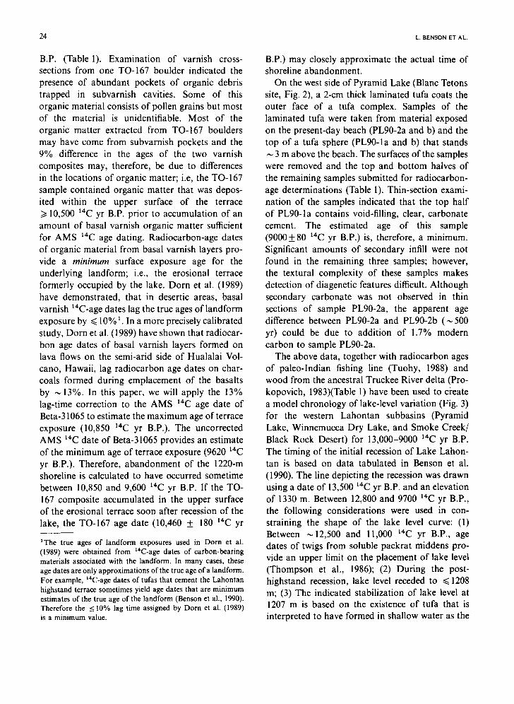
The above data, together with radiocarbon ages of paleo-Indian fishing line (Tuohy, 1988) and wood from the ancestral Truckee River delta (Pro- kopovich, 1983)(Table l) have been used to ci'eate a model chronology of lake-level variation (Fig. 3) for the western Lahontan subbasins (Pyramid Lake, Winnemucca Dry Lake, and Smoke Creek/ Black Rock Desert) for 13,000-9000 14C yr B.P. The timing of the initial recession of Lake Lahon- tan is based on data tabulated in Benson et al. (1990). The line depicting the recession was drawn using a date of 13,500 14C yr B.P. and an elevation of 1330 m. Between 12,800 and 9700 14C yr B.P., the following considerations were used in con- straining the shape of the lake level curve: (I) Between ~12,500 and 11,000 14C yr B.P., age dates of twigs from soluble packrat middens pro- vide an upper limit on the placement of lake level (Thompson et al., 1986); (2) During the post- highstand recession, lake level receded to ~< 1208 m; (3) The indicated stabilization of lake level at 1207 m is based on the existence of tufa that is interpreted to have formed in shallow water as the
LAKE-SIZE VARIATIONS IN THE I.AHONrAN AND BONNEVILLE BASINS 25
1250 J l l l l l l l l l l I l l l l l l l l l l ' l l l l l l l l l l l l l ) ' q -" Owood a,~s,t*d ~law lake mv*l /
1240 00eQont¢ co fb~ depositeO above Iakl I~el • Tufa O ~ o l l t l d bl law lake le~ll
~'~ Organic carbon asso¢lotlld ~ I ~ I
E 1230 .,,.,ocw.a,n,s~ / z / O_ 1220 ~ ~ / I- / \ /
1210 / "~/Eme,so? . ~ _Si_ll .J
" ' 1200 bl.l U
Ull 1180 1 ~ Mud I_ake SlouQh Sill ~
- J - - - - Est,moted lake level
Jt6o ~ ~ ~ ~ _. . . . . . . ,,,Q . . . . . ; f l
1150 {'' , ,,,,I,,,,I,,,~
9000 I0,000 I 1,000 12,000 13,000
TIME (yr B.P.)
Fig. 3. Model chronology for Lake Lahontan 13,000-9000 "LC yr B.P. Open circles plotted at elevations > 1225 m indicate samples of organic carbon extracted from water-soluble packrat middens (Thompson et al., 1986). The upper end of the line depicting the recession was drawn from an elevation of 1330 m and a '4C age of 13,500 yr B.P. Between 12,800 and 9700 " C yr B.P., the following considerations were used in constrain- ing the shape of the lake level curve: (1) Between ~ 12,500 and 11,000 ~'C yr B.P, age dates of twigs from soluble packrat middens provide an upper limit on the placement of lake level (Thompson et al.. 1986); (2) During the post-highstand reces- sion, lake level retreated to at least 1208 m - - t h e base of the platform cut during the following rise in lake level; (3) The indicated stabilization of lake level at 1207 m is based on the existence of tufa that is interpreted to have formed in shallow water as the lake spilled to the Smoke Creek/Black Rock Desert subbasin ~ 11,300 ~'C yr B.P.; (4) The max imum level achieved during the transgression could not have exceeded the lower elevational limit of the soluble packrat middens (1230 m) but must have been higher than the elevation of the rock varnish (1220 m) that formed after the lake receded; (5) Recession from the 1220-m level has been shown as occurring somewhat prior to 10,600 " C yr B . P - - t h e age of organic matter entrapped in the upper surface o f the terrace eroded into Anaho Island; (6) The indicated stabilization of lake level at 1207 m is based on the existence of tufa that is interpreted to have formed in shallow water as the lake spilled to the Smoke Creek/Black Rock Desert subbasin ~ 10,100 '4C yr B.P.; (7) The recession in lake level between 10.000 and 9700 ~4C yr B.P. is tightly constrained by ~4C age dates on both tufas and wood. The arrow drawn from the rock-varnish organic carbon sample indicates the amount of time that may have elapsed since the exposure of the terrace to the atmosphere (~< 13% of the ~'~C age of the sample). An similar arrow has not been attached to the other organic carbon sample since it may represent material deposited within the terrace surface soon after exposure of the terrace to the atmosphere.
lake spilled to the Smoke Creek/Black Rock Desert subbasin --, 1 !,400 '4C yr B.P.; (4) The maximum level achieved during the transgression could not have exceeded the lower elevational limit of the soluble packrat middens (1230 m) but must have been higher than the elevation of the rock varnish (1220 m) that formed after the lake receded; (5) Recession from the 1220-m level has been shown as occurring somewhat prior to 10,600 '4C yr B.P--the age of organic matter entrapped in the upper surface of the terrace eroded into Anaho Island; (6) The indicated stabilization of lake level at 1207 m is based on the existence of tufa that is interpreted to have formed in shallow water as the lake spilled to the Smoke Creek/Black Rock Desert subbasin ,-, 10,100 t4C yr B.P.; (7) The recession in lake level between 10,000 and 9700 14C yr B.P. is tightly constrained by t4C age dates on both tufas and wood.
Lake-level variation in the Bonneville basin between 13,000 and 9000 t4C yr B.P.
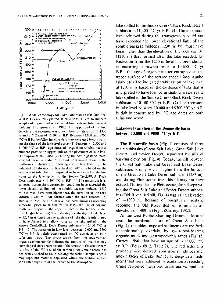
The Bonneville basin (Fig. 1) consists of three main subbasins (Great Salt Lake, Great Salt Lake Desert, and Sevier Desert) separated by sills of varying elevation (Fig. 4). Today, the sill between the Great Salt Lake and Great Salt Lake Desert subbasins is only ~2 m higher than the bottom of the Great Salt Lake Desert subbasin (1283 m), and during Pleistocene time, this sill may not have existed. During the late Pleistocene, the sill separat- ing the Great Salt Lake and Sevier Desert subbas- ins (Old River Bed sill, Fig. 4) was at an elevation of ~ 1390 m. Because of postpluvial isostatic rebound, the Old River Bed sill is now at an elevation of 1400 m (Fig. 5)(Currey, 1982).
At the west Public Shooting Grounds, located near the northeast shore of Great Salt Lake (Fig. 4), the oldest exposed sediments are red beds unconformably overlain by gastropod-bearing organic m.qds and gastropod-rich sands (Fig. 15, Currey, 1990) that have an age of ---12,000 t4C yr B.P. (Beta-16912, Table2). The red sediments probably were derived from iron sulfide bearing, anoxic facies of Lake Bonneville deep-water sedi- ments that were reddened by oxidation as receding brines reworked them basinward across mudflats
26 L. BENSON ET AL.
42*
41"
4 0 *
39*
3 8 °
114 ° 1130 112 °
Fig. 4. Map of the Lake Bonneville region depicting the open- basin (Bonneville) stage prior to the Bonneville Flood, the highest (Gilbert) stage of Great Salt Lake subsequent to the final regression of Lake Bonneville, and the areas of present- day Great Salt Lake and Utah Lake (adapted from Currey, 1990).
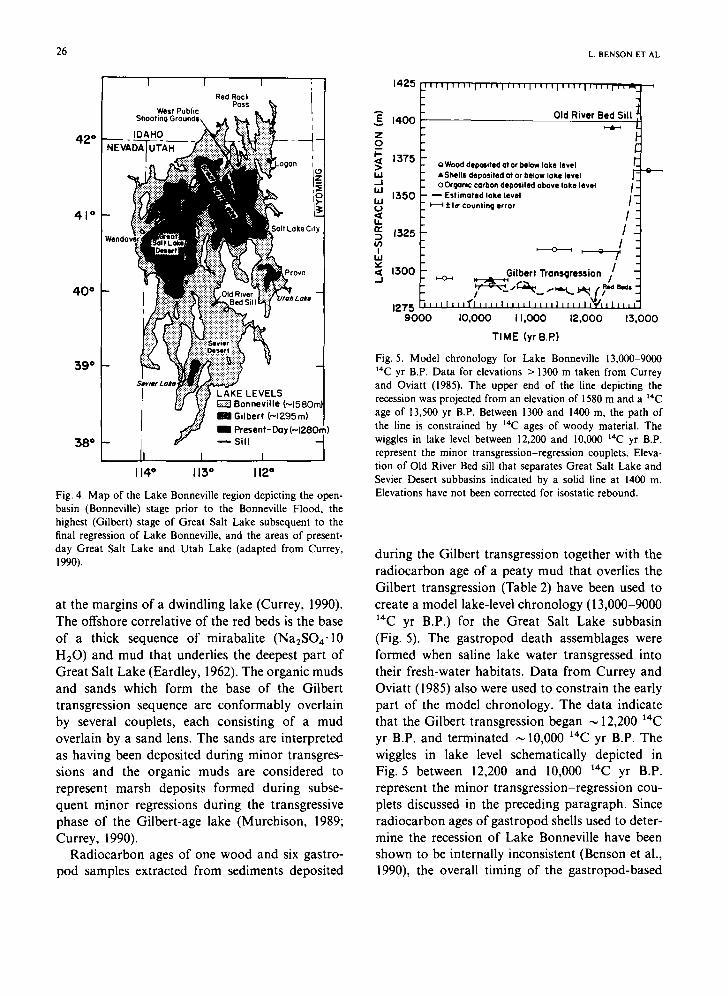
at the margins of a dwindling lake (Currey, 1990). The offshore correlative of the red beds is the base of a thick sequence of mirabalite (Na2SO4-10 H20) and mud that underlies the deepest part of Great Salt Lake (Eardley, 1962). The organic muds and sands which form the base of the Gilbert transgression sequence are conformably overlain by several couplets, each consisting of a mud overlain by a sand lens. The sands are interpreted as having been deposited during minor transgres- sions and the organic muds are considered to represent marsh deposits formed during subse- quent minor regressions during the transgressive phase of the Gilbert-age lake (Murchison, 1989; Currey, 1990).
Radiocarbon ages of one wood and six gastro- pod samples extracted from sediments deposited
E v
z o I I - -
LIJ .J bJ bJ o 14. r~
(n I hi
V '< ..J
1425 , t , l i i i , i t , i l l i i i i 1 1 , 1 1 1 , , , , i , , , i i , , , . i . , ,
1400 Old River Bed Sill
1375 ; ) W o o d d e p o s i t e d o t o r below lake level A S h e l l s d e p o s i t e d a t o r below lake level "¢ :
o o,g*~c c°rbo, depo, itod above I°~o level I - [ 5 5 0 ~ Estimated lake level /-
~ 1 ¢ la" C o u n t i n g e r r o r
I
1325 / !
G i l b e r t T r a n s g r e s s i o n 1/ 1300
1 2 7 5 t t I [ I I l ' r ' i I I I I I I I I t I I I I I I I t I I I l ~ / l l I | I l t
9 0 0 0 I0 ,000 I 1,000 12,000 13,000
T IME (yr B.P.)
Fig. 5. Model chronology for Lake Bonneville 13,000-9000 14C yr B.P. Data for elevations > 1300 m taken from Currey and Oviatt (1985). The upper end of the line depicting the recession was projected from an elevation of 1580 m and a 14C age of 13,500 yr B.P. Between 1300 and 1400 m, the path of the line is constrained by 14C ages of woody material. The wiggles in lake level between 12,200 and 10,000 laC yr B.P. represent the minor transgression-regression couplets. Eleva- tion of Old River Bed sill that separates Great Salt Lake and Sevier Desert subbasins indicated by a solid line at 1400 m. Elevations have not been corrected for isostatic rebound.
during the Gilbert transgression together with the radiocarbon age of a peaty mud that overlies the Gilbert transgression (Table 2) have been used to create a model lake-level chronology (13,000-9000 14C yr B.P.) for the Great Salt Lake subbasin (Fig. 5). The gastropod death assemblages were formed when saline lake water transgressed into their fresh-water habitats. Data from Currey and Oviatt (1985) also were used to constrain the early part of the model chronology. The data indicate that the Gilbert transgression began ~ 12,200 14C yr B.P. and terminated ~ 10,000 ~4C yr B.P. The wiggles in lake level schematically depicted in Fig. 5 between 12,200 and 10,000 ~4C yr B.P. represent the minor transgression-regression cou- plets discussed in the preceding paragraph. Since radiocarbon ages of gastropod shells used to deter- mine the recession of Lake Bonneville have been shown to be internally inconsistent (Benson et al., 1990), the overall timing of the gastropod-based
LAKE-SIZE VARIATIONS IN THE LAHONTAN AND BONNEVILLE BASINS
TABLE 2
Number, type, locality, elevation, and radiocarbon ages of samples from the Bonneville basin
27
Sample number Sample type Locality information Elevation 14C age (m) (yr B.P.)
Great Salt Lake subb~z, in Beta-218071 peaty mud Juke Box trench, mud overlies Gilbert 1295 9450 ± 150
beach gravel GX-6614 b gastropod shells Magna spit, lagoonal marsh at Gilbert 1294 10,285___265
shoreline GX-6949 b gastropod shells Magna spit, lagoonal marsh at Gilbert 1294 10,300+ 310
shoreline 1-696 ¢ wood Willard Canal, overlain by sand of 1290 10,300 ± 275
Gilbert transgression W-4395 a gastropod shells Shooting Grounds, marsh predating 1289 10,920 + 150
rise to Gilbert shoreline Beta-2243 I' gastropod shells Shooting Grounds, transgressive sand 1289 10,990 + I 10
in marsh Beta-16913 f gastropod shells Shooting Grounds, transgressive sand 1288 11,570+ 100
in marsh Beta-16912 f gastropod shells Shooting Grounds, transgressive sand 1288 11,990+ 100
in marsh
Sevier Desert subbasin Beta-12987* gastropod shells alluvial mud overlying lacustrine 1387
sediment Betao19455 h Anodonta shells lacustrine mud adjacent to shoreline 1385 10,070+ 130 GX-6776 ~ Anodonta shells lacustrine mud adjacent to shoreline 1385 10,360+225 Beta-17883 h Anodonta shells lacustrine mud adjacent to shoreline 1385 11,270± I10
9570± 530
a13C set to - 2 5 . bpreviously reported in Currey et al. (1983b). 'previously reported in Trautman and Willis (1966). ~previously reported in Miller (1980). "previously reported in Murchison (1989). fpreviously reported in Currey (1990). *previously reported in Simms (1985). "previously reported in Oviatt (1987). ~previously reported in Currey (1980).
Gilbert transgression also may be shifted in time; i.e., some of the gastropod ages may be too young.
In the Sevier Desert subbasin (Fig. 4), radiocar- bon ages of molluscs (Table 2) indicate that Sevier Lake spilled across the Old River Bed sill to the Great Salt Lake subbasin between ,--11,300 and 10,100 ~4C yr B.P. Oviatt (1988) indicates that Sevier Lake was full and spilling when Lake Bonneville receded below the Old River Bed sill ~ 13,000 ~4C yr B.P. However, lake-level data for the Sevier Desert subbasin are lacking between 13,000 and 11,300 ~4C yr B.P. and it is possible that Sevier Lake receded below sill level (Fig. 5) at the same time the lake in the Great Salt Lake
subbasin was undergoing redbed formation and mirabalite deposition.
Surface areas of lakes in the Lahontan and Bonneville basins I 1,000 14C yr B.P.
In this paper, surface area is used as an indicator of change in the hydrologic balance. We follow the procedure suggested by Benson and Paillet (1989), whereby the surface area of a paleolake is normalized by dividing its paleosurface area by its mean historical, reconstructed surface area (PDCSA). In the Lahontan basin, PDCSA (Table 3) was derived using the reconstructed mean
28
TABLE 3
Surface areas of past and present-day lakes in the Bonneville and Lake Lahontan basins.
Surface areas of the Bonneville and Lahontan basirt~ Bonneville basin= 139,500 km 2 (Currey and Oviatt, 1985) Lahontan basin = 114,700 km 2 (Mifflin and Wheat, 1979) Surface areas of highstand Lakes Bonneville and Lahontan Lake Bonneville highstand t> 51,300 km 2 (Currey et al., 1983a) Lake Lahontan highstand=22,200 km 2 (Benson and Mifflin, 1986) Calculated surface areas of present-day lakes in the Bonneville basin (PDCSA) Great Salt Lake = 6170 km 2 [obtained using reconstructed sur- face areas of Great Salt Lake from 1851 to 1984 (Stauffer, 1985) and linear piecewise regression of Great Salt Lake area- elevation curve (Fig. 16, Currey, 1990)] Utah Lake=/>400 km 2 (obtained from Currey et al., 1983a) Calculated surface areas of present-day lakes in the Lahontan basin [obtained using river discharge and precipitation data listed in Tables 2 and 3 of Benson and Thompson (1987) and an evaporation rate of 1.25 m/yr].
River Subbasin/s Surface area
Susan River Honey Lake 100 km 2 Truckee River Pyramid Lake, Winnem- 670 km 2
ucca Dry Lake Carson River Carson Desert 405 km 2
Walker River Walker Lake 360 km 2
Quinn River Smoke Creek/Black Rock 35 km 2 Desert
Humboldt River Carson Desert 905 km 2 Total surface area= 2475 km z
Ratio of highstand surface areas to PDCSA Lake Bonneville= 51,300 km2/6570 km 2 > 7.8 (minimum due to downcutting that occurred during Bonneville Flood) Lake Lahontan = 22,200 km2/2475 km 2 = 9.0 Ratio of PDCSA of lakes to drainage basin areas in the Bonneville and Lahontan basins Bonneville system = 6570 km2/139,500 km 2= 0.047 Lahontan system = 2475 km2/114,700 km 2 = 0.022
annual streamflow-discharge and precipitation data and an evaporation rate of 1.25 m/yr (Benson and Thompson, 1987) in the following form of the water-balance equation for a closed-basin lake:
A~ = D/(EcP,) (1)
where A~= calculated surface area of the closed- basin lake, D = volume of streamflow discharge, E~=lake-evaporation rate, and P~=precipitation on the lake surface. The PDCSA is, therefore, a
L. BENSON ET AL
hypothetical area that would exist if the bottoms of closed-basin lakes were truly impermeable.
In the Bonneville basin, the mean annual surface area of Great Salt Lake was calculated using reconstructed annual elevations of Great Salt Lake from 1851 to 1984 (Stauffer, 1985). The mean elevation for each year of record was converted to surface area using the elevation-area data listed in Kay and Diaz (1985, appendix I). The area of Utah Lake was taken from Currey et al. (1983a) and the Sevier Lake subbasin was assumed to have, on the average, remained dry since 1850.
Because of the topographic complexity of the Lahontan basin and the limited number of subbas- ins for which lake-level chronologies are available, total lake-surface areas for 11,000 14C yr B.P can only be approximated (Table 4, Fig. 6). A lake- surface elevation of 1220 m for the western Lahon- tan subbasins was used in the surface area calcula-
tions. River diversion has played a role in regulating lake levels (surface areas) in Lahontan subbasins and any discussion of past change in the hydrologic balance of the Lahontan basin based on lake level data from a subbasin must account for the possibility that river diversion was responsible for part or all of the observed change in lake level in that subbasin (Benson and Paillet, 1989). Calculations that account for the possibility of river diversion at 11,000 t4C yr B.P. (Table 4)
indicate that the combined surface area of lakes in the Lahontan basin was >2.9 PDCSA. Given present-day river configurations, calculations indi- cate that the surface area of the lake in the Carson Desert subbasin was ~2.3 times PDCSA and the combined surface area of lakes in the western Lahontan subbasins was 5.7 times PDCSA at 1 1,000 14C yr B.P. (Table 4).
For the Bonneville basin, calculations (Table 5) indicate that ~ 1 !,000 ~4C yr B.P the total surface area of lakes was ~17 ,300km 2 (~2 .6 times PDCSA). The similarity of surface area increases of lakes in the Carson Desert subbasin and the Bonneville basin (2.3 and 2.6 times PDCSA) and the magnitude of these increases relative to surface- area increases of lakes in western Lahontan sub- basins (5.7 times PDCSA) indicate that change in the effective wetness was not homogeneous over the northern Great Basin area 11,000 14C yr B.P.
I.AKE-SIZE VARI,~FIONS IN THE LAHONTAN AND BONNEVILLE BASINS 29
TABLE 4
Calculated present-day and II,000 yr B.P. elevations (m) and surface areas (km z) of lakes in the Lake Lahontan basin. [PL = Pyramid Lake subbasin; WDL = Winncmucca Dry Lake subbasin; SC = Smoke Creek- Blackrock Desert subbasin; HL = Honey Lake subbasin; C D = C a r s o n Desert subbasin; WL = Walker Lake subbasin; TSA = total surface area of lakes in the six subbasins; ele = elevation; WR = Walker Rivcr: H R =
Humboldt River: - > . river diversion]
PL WDL SC HL CD WL TSA
Present-day simulation ele (m) 1177 1153 1171 1217 1183 1259 area (km 2) 570 100 35 100 13 I0 360 2475
11,000 yr B.P. simulation ele (m) 1220 1220 1220 > 1217 1203 > 1259 area (km 2) 715 ~ 360 ~ 2950 ~ > 100 b 2990 ¢ > 360 > 7475
11.000 yr B.P. simulation, WR- > CD ele (in) 1220 1220 1220 > 1217 1203 0 area (km 2) 715 h 360 b 2950 b > lO0 2990 d 0 > 7I 15
11,000 yr B.P. simulation, HR- > SC ele (m) 1220 1220 1220 > 1217 1203 > 1259 area (km 2) 715 c 360 e 2950' > 100 2990 f > 360 > 7475
11,000 yr B.P. simulation, IIR- > SC, WR- > CD
ele (m) 1220 1220 1220 > 1217 1203 0 area (km ~) 715 c 360' 2950 ~ > I00 2990 g 0 > 7115
~Thc total surface area of lakes in the PL, WDL, and SC was 5.7 times their PDCSA. hlf change in the surface area of the lake in the HL corresponded to change in the surface areas of lakes in PL. WDL, and SC, Honey Lake would have spilled contributing 35 km 2 to SC. 'The surface area of the lake in the CD was 2.3 times its PDCSA; however, if change in the surface area of the lake in the WL corresponded to change in the surface areas of lakes in PL, WDL, and SC, and Walker Lake spilled to CD, the surface area of the lake in the CD was 1.3 times the PDCSA of the lakc in CD associated with discharge of the Carson and Humboldt Rivers. dlf the Walker River diverted to the CD, the surface area of the lake in CD was 1.8 times the PDCSA of lakes in CD and WL. elf the Humboldt River diverted to the SC, the total surface area of lakes in PL, WDL, and SC was 2.5 times their PDCSA associated with discharge of the Quinn and Truckee Rivers. flf the Humboldt River diverted to the SC, the surface area of the lake in CD was 7.4 times the PDCSA associated with discharge of the Carson River to the CD. However, if change in the surface area of the lake in the WL corresponded to change in the total surface area of lakes in PL. WDL, and SC, Walker Lake would have overflowed to CD and the surface area of the lake in the CD was 7.1 times the PDCSA associated with discharge of the Carson River to the CD. Slf the Walker River diverted to CD, and the Humboldt River diverted to the SC, the surface area of the lake in CD was 3.9 times the PDCSA associated discharge of the Carson River to the CD.
TABLE 5
Surface areas of lakes in the Bonneville basin at ~ 11,000 yr B.P.
Great Salt Lake subbasin= 16,300 km 2 (1295-m ele) Sevier Lake subbasin = ~600 km z
Utah Lake= ~ 400km 2 Total surface area (TSA) = ~ 17,300 km 2
TSA/PDCSA = ~ 2.6
Inhomogeneity of effective wetness may have been due to a number of factors including difference in the latitudinal distribution of storm systems (head- waters of the western Lahontan subbasins are located between 38 and 40°N latitude and the headwaters of both the Bonneville and Humboldt River basins are located between 40 and 42°N latitude) and orographic blocking of westerly storms by the Sierra Nevada. By 9500 14C yr B.P.,
30 L. BENSON ET AL.
(0) QR HR
sR
0 yr. B.P.
(b) OR ,R
WR ~ WL i~1.3!_1 wL-co
1(5.7)PL--SCq~(7. I )'~ HR-- SC, WL--CD S R ~ ~.5'PL--$C~ HR--SC,WR--CO
CR
I 1 ,000 yr B.P.
Fig. 6. Schematic representation of surface areas (stippled pattern) of lakes in Lahontan subbasins at 0 and ~ 11,000 14C yr B.P. (see Table 4 for subbasin abbreviations; QR= Quinn River, BV= Buena Vista subbasin, SR= Susan River). Solid lines connecting subbasins indicate sills and arrows indicate intersubbasin spill or streamflow discharge. Numbers in parentheses indicate the surface area/PDCSA ratio for the time of interest. Question marks centered in subbasins indicate that lake-size information is lacking, and question marks/dashed lines from catchment areas indicate the possibility of river diversion. Each square indicates an area of I00 km 2. See footnotes in Table 4 for discussion of surface-area calculations.
lakes in both Lahontan and Bonneville basins had receded, achieving surface areas similar to their PDCSAs (Figs. 3 and 5).
Mountain glaciation in the Great Basin between 13,000 and 9000 14C yr B.P.
Dorn et al. (1990) have found evidence for a young glaciation in the Chiatovich Cirque area of the White Mountains of Nevada-California (Elliot-Fisk, 1987). Basal layers of rock varnish coating boulders at this locality have a radiocarbon age of 9740+210 ~4C yr B.P., an age consistent with the measured in situ accumulation of ~4C (Jull et al., 1989) and 36C1 (Zreda et al. 1991). The estimated time of till deposition (between 11,100 and 9700 ~4C yr B.P.), calculated assuming that the measured age is within 13% of the time of till deposition, is consistent with the data of Mezger and B;u .thank (~1986) who obtained radiocarbon ages of J0,640-t- 160, 10,320+ 110, and 10,060+ 130 14C yr B.P. on basal material from a bog formed behind a moraine in the southeastern Sierra Nevada.
Summary and discussion
Recessions from highstand levels in the Lahon- tan and Bonneville basins were reversed when lakes began to rise >/11,500 14C yr B.P. in the Lahontan basin and ~ 12,200 14C yr B.P. in the Bonneville basin. The perturbations in lake level lasted for ,-,2000 yr, and between 10,000 and 9500 14C yr B.P., lakes in both basins abruptly receded. The total surface areas of lakes in the Lahontan and Bonneville basins were > 2.9 and 2.6 PDCSA --- 11,000 14C yr B.P. Given present-day river con- figurations, surface areas of lakes in western Lahontan subbasins increased about twice as much as lakes in the Bonneville and Carson Desert basins. The inhomogeneous distribution of change in effective wetness may have been due to difference in the latitudinal distribution of storm systems or to orographic blocking of westerly storm systems by the Sierra Nevada. During the last phase of lake transgressions in the Lahontan and Bonneville basins, minor glacial advances occurred in the Sierra Nevada and White Mountains.
Within the accuracy of the chronologies, the
LAKE-SIZF. VARIAI'IONS IN "IItE LAHONTAN AND BONNEVILLE BASINS 31
12,000-10,000 I4C yr B.P. perturbations in lake level that occurred in the Lahontan and Bonneville basins were concurrent with the European Aller~d and Younger Dryas intervals. Advances of moun- tain glaciers in the Sierra Nevada and White Mountains appear to be concurrent with the Youn- ger Dryas interval. However, we do not believe that the reliability and accuracy of the 14C age dates on which the lacustrine chronologies are based are sufficient to assert that the lakes rose during the Younger Dryas interval and fell during the Allerod interval or that their rise and fall was confined to only one interval. Given the inherent inaccuracies of the chronologies, we could just as well assert that the lake-level perturbation began in the middle of the Aller~d interval and ended after the termination of the Younger Dryas interval.
Acknowledgments
The authors wish to thank Ron Dorn of the Arizona State University for the AMS radiocarbon age determinations of the two rock varnish samples funded by NSF EAR87-57014. The authors also wish to thank Vera Markgraf of the Institute of Arctic and Alpine Research, Bruce Allen of the University of New Mexico, Scott Stine of Cali- fornia State University-Hayward, and Fred Pail- let, William Scott, Robert Thompson, and Barney Szabo of the U.S. Geological Survey for comments on earlier versions of this manuscript. Paleolake research at the University of Utah has been par- tially funded by NSFEAR-9721114 and USGS 14- 08-0001-G 1536.
References
Anderson, T.W., 1983. Preliminary evidence for Late Wisconsin climatic fluctuations from pollen stratigraphy in Buren Penin- sula, Newfoundland. In: Curr. Res. Part B, Geol. Surv. Can. Pap., 83-1B: 185-188.
Benson, L.V. and Mifflin, M.D., 1986. Reconnaissance bathym- etry of basins occupied by Pleistocene Lake Lahontan, Nevada and California. U.S. Geol. Surv. Water-Resour. Invest. Rep., 85-4262, 14 pp.
Benson, LV. and Paillet, F.L., 1989. The use of total lake- surface area as an indicator of climatic change: Examples from the Lahontan basin. Quat. Res., 32: 262-275.
Benson, L.V. and Thompson, R.S., 1987. The physical record of lakes in the Great Basin. In: W.F. Ruddiman and H.E.
Wright Jr.(Editors), North America and Adjacent Oceans during the Last Deglaciation (Geol. North Am., K-3). Geol. Soc. Am., Boulder, CO, pp. 241-259.
Benson, L.V., Currey, D.R., Dorn, R.I., Lajoie, K.R., Oviatt, C.G., Robinson, S.W. and Smith, G.I.. 1990. Chronology of expansion and contraction of four Great Basin lake systems during the past 35,000 years. In: P.A. Meyers and L,V. Benson (Editors), Paleoclimates: the Record from Lakes, Ocean and Land. Palaeogeogr., Palaeoclimatol.. Palaeoecol., 78: 241-286.
Born, S.M., 1972. Late Quaternary history, deltaic sedimenta- tion, and mudlump formation at Pyramid Lake, Nevada. Univ. Nevada, Desert Res. Inst., 97 pp.
Currey, D.R., 1980. Radiocarbon dates and their stratigraphic implications from selected localities in Utah and Wyoming. Encyclia (J. Utah Acad. Sci. Arts Lett.), 57:110-115.
Currey, D.R., 1982. Lake Bonneville: Selected features of relevance to neotectonic analysis. U.S. Geol. Surv. Open- File Rep., 82-1070, 30 pp.
Currey, D.R., 1988. Isochronism of final Pleistocene shallow lakes in the Great Salt Lake and Carson Desert regions of the Great Basin. In: AMQUA Progr. Abstr. Tcnth Biennial Meet., p. I 17.
Currey, D.R., 1989. Late Quaternary geomorphology of the Great Salt Lake region, Utah, and other hydrographically closed basins in thc western United States: A summary of observations. Univ. Utah Limneotect. Lab. Tech. Rep., 89- 3, 77 pp.
Currey, D.R., 1990. Quaternary paleolakes in the cvolution of semidesert basins, with special emphasis on Lake Bonneville and the Great Basin, U.S.A. Palaeogeogr., Palaeoclimatol., Palaeoecol., 76: 189-214.
Currey, DR. and Oviatt, C.G., 1985. Durations, avcrage rates, and probable causes of Lake Bonneville expansions, still- stands, and contractions during the last deep-lake cycle, 32,000 to 10,000 years ago. In: P.A. Kay and H.F. Diaz (Editors), Problems of and Prospects for Predicting Great Salt Lake Levels, Proc. Conf., Salt Lake City, March 1985. Center Publ. Affairs Admin., Univ. Utah, pp. 168-178.
Currey, D.R., Atwood, G. and Mabey, D.R., 1983a. Major levels of Great Salt Lake and Lake Bonneville. Utah Geol. Min. Surv. Map, 73.
Currey, D.R., Oviatt, C.G. and Plyer, G.B., 1983b. Lake Bonneville stratigraphy, geomorphology, and isostatic defor- mation in West-Central Utah. In: Geologic Excursions in Neotectonics and Engineering Geology in Utah. Utah Geol. Min. Surv. Spec. Stud., 62: 63-82.
Dorn, R.I., Jull, A.J.T., Donahue, D.J.. Linick, T.W. and Toolin, L.J., 1989. Accelerator mass spectrometry radiocar- bon dating of rock varnish. Geol. Soc. Am. Bull., 101: 1363- 1372.
Dorn, R.I., Jull, A.J.T., Donahue, D.J., Linick, T.W. and Toolin, L.J., 1990. Latest Pleistocene lakc shorelines and glacial chronology in the western Basin and Range Province, USA: Insights from AMS radiocarbon dating of rock varnish and paleoclimatic implications. In: P.A. Meyers and L.V. Bcnson (Editors), Paleoclimates: the Record from Lakes, Ocean and Land. Palaeogeogr., Palaeoclimatol., Palaeoecol., 78: 315-332.
Elliot-Fisk, D.L., 1987. Glacial geomorphology of the White
32 L. BENSON ET AL.
Mountains, California and Nevada: establishment of a glacial chronology. Phys. Geogr., 8: 299-323.
Eardley, A.J., 1962. Gypsum dunes and evaporite history of the Great Salt Lake Desert. Utah Geol. Min. Surv. Spec. Stud., 2, 27 pp.
Jull, A.J.T., Donahue, D.J., Linick, T.W. and Wilson, C.G., 1989. Spallogenic carbon-14 in high altitude rocks and Ant- arctic meteorites. Radiocarbon, 32: 717-722.
Kay, P.A. and Diaz, H,F., 1985. Problems of and prospects for predicting Great Salt Lake levels. In: P.A. Kay and H.F. Diaz (Editors), Proc. Conference, Salt Lake City, March 1985, Center Publ. Affairs Admin., Univ. Utah, Monogr., 14: 121-133.
Krinsley, D.H., Dorn, R.I. and Anderson, S., 1990. Factors that may interfere with the dating of rock varnish. Phys. Geogr., II: 97-119.
Livingstone, D.A. and Livingstone, B.G.R., 1958. Late-glacial and postglacial vegetation from Gillis Lake in Richmond County, Cape Breton Island, Nova Scotia, Am. J. Sci., 256: 341-359.
Mangerud, J., Andersen, S.T., Berglund, B.E. and Donner, J.J., 1974. Quaternary stratigraphy of Norden, a proposal terminology and classification. Boreas, 3: 109-128.
Mezger, L. and Burbank, D., 1986. The glacial history of the Cottonwood Lakes area, southeastern Sierra Nevada. Geol. Soc. Am. Abstr. Pap., 18, p. 157.
Mit~in, M.D. and Wheat, M.M., 1979. Pluvial lakes and estimated pluvial climates of Nevada. Nev. Bur. Mines Geol. Bull., 94, 57 pp.
Miller, R.D., 1980. Surficial geologic map along part of the Wasatch Front, Salt Lake Valley, Utah. U.S. Geol. Surv. Misc. Field Stud. Map MF-1198.
Mott, R.J., 1985. Late-glacial climatic change in the maritime provinces. Syllogeus, 55: 281-300.
Mott, R.J., Grant, D.R., Stea, R. and Ochietti, S., 1984. The Allerod-Younger Dryas transition in North America--Fact or fiction? In: 6th Int. Palynol. Conf., p. 112.
Murchison, S.B., 1989. Fluctuation history of Great Salt Lake, Utah, during the last 13,000 years. Univ. Utah Limneotect. Lab. Tech. Rep., 89-2, 137 pp.
Oviatt, C.G., 1987. Lake Bonneville stratigraphy at the Old River Bed, Utah. Am. J. Sci. 287: 383-398.
Oviatt, C.G., 1988. Late Pleistocene and Holocene lake fluctua- tions in the Sevier Lake Basin, Utah, USA. J. Paleolimnol., I: 9-21.
Prokopovich, N.P., 1983. Alteration of alluvium by natural gas in the Pyramid Lake area. Nev. Bull. Assoc. Eng. Geol., 20: 185-196.
Shane, L.C.K., 1987. Late-glacial vegetational and climatic history of the Allegheny Plateau and the till plains of Ohio and Indiana. Boreas, 16: 1-20.
Shane, L.C.K., 1990. A regional short term climatic reversal during the late-glacial in the Ohio/Indiana/Michigan area of North America. In: CANQUA First Joint Meet. Progr. Abstr., p. 30.
Simms, S.R., 1985. Radiocarbon dates from 42MD300, Sevier Desert, western Utah. Weber State College Archaeol. Tech. Progr. Rep., 9.
Stauffer Jr., N.E., 1985. Great Salt Lake water balance model. In: P.A. Kay and H.F. Diaz (Editors), Problems of and Prospects for Predicting Great Salt Lake Levels, Proc. Conf., Salt Lake City, March 1985, Center Publ. Affairs Admin., Univ. Utah, pp. 168-178.
Stine, S.W., 1987. Mono Lake: The Past 4000 Years. Thesis. Univ. California-Berkeley, 615 pp.
Thompson, R.S., Benson, L.V. and Hattori, E.M., 1986. A revised chronology for the last Pleistocene lake cycle in the central Lahontan basin. Quat. Res, 25: 1-9.
Trautman, M.A. and Willis, E.H., 1966. Isotopes incorporated radiocarbon measurements V. Radiocarbon, 8: 161-203.
Tuohy, D.R., 1988. Artifacts from the northwestern Pyramid Lake shoreline. Nev. State Mus.. Anthropol. Pap., 21: 201-216.
Wright Jr., H.E., 1989. The amphi-Atlantic distribution of the Younger Dryas paleoclimatic oscillation. Quat. Sci. Rev., 8: 295-306.
Zreda, M.B., Phillips, F.M., Elmore, D., Kubik, P.W., Sharma, P., and Dorn, R.I., 1991. Cosmogenic chlorine-36 produc- tion rates in terrestrial rocks. Earth Planet. Sci. Lett., 105: 94-109.