Embed Size (px)
Citation preview
j
LAND AND NATURAL RESOURCES CONFLICTS IN
TRANSBOUNDARY AGROECOSYSTEM MANAGEMENT
PROJECT KAGERA BASIN.
Syprose Achieng’ Ogola (International Consultant)
ii
Acronyms
CNND‐FDD‐ Conseil National pour la defense de la democratie – Force de
defense de la Democratie
CNTB‐ Commission National des Terres et Autres Biens.
DRC‐Democratic Republic of Congo
EAC‐ East Africa Community
FAO‐ Food and Agriculture Organization
FGD‐ Focus group discussions
FFS – Farmer Field Schools
FNA‐ Forest National Authority
IDPS ‐ Internally Displaced Persons
KI ‐ Key Informants
LSSP‐ Land Sector Strategic Plan
NEMA ‐ National Environment Management Authority
PNT ‐ Participatory Territorial Diagnosis
SDC ‐ Swiss Agency for Development and Cooperation
TAMP ‐ Trans boundary Agro ecosystem management Project
WC ‐ Welcoming Capacity
iii
Acknowledgements
This report has benefited from diverse contributions from several people in the four countries.
Focus group discussions (FGDs) and key informants (KI) composed of women, men youths, and Government Staff, Civil Societies Organizations and Village leaders. Their wealth of knowledge and experience has been an important source of information for this work. To you all I thank you for your valuable contribution. I am grateful to TAMP Kagera Regional Coordinator, Joseph Anania, and NPMs for Burundi Salvator Ndabirorere, Uganda Wilson Bamwerinde and Tanzania Fidelis Kaihura for providing overwhelming support and necessary information that provided substance to this report. I am grateful to FAO Offices in Kigali, Bujumbura, Kampala and Dar es Salaam for their logistical support. My special thanks are due to Sally Bunning and Paolo Groppo who inspired me to explore further into understanding conflicts and policy issues for improving sustainable natural resources management.
The views expressed in this report, any oversights and errors in the interpretation and
analysis of facts, are however, my sole responsibility.
iv
Executive Summary
This assessment report on land and other natural resources conflicts in part, addresses the
second outcome of the Trans boundary agro‐ecosystem management project in the Kagera
Basin that enabling policy planning and legislative conditions are in place to support and
facilitate the sustainable management of agro‐ecosystem and restoration of degraded land.
Specifically, component 2.2 Regulatory actions and conflict resolution mechanisms
developed and used to promote ‐ or remove existing barriers to ‐ sustainable land and agro‐
ecosystem management.
Kagera River Basin possesses land and other natural resources (forests, grazing areas, wildlife, water
& wetlands) that support cultural, socio‐economic development, food security and communities’
livelihoods in the basin. However, population pressure is creating conflicts that threaten sustainable
land and agro‐ecosystem management. The report elucidates the contexts in which access to
land operates in Rwanda, Burundi, Uganda and Tanzania which are so important for the
project in adopting an integrated ecosystem approach for the sustainable management of
land and other natural resources in Kagera Basin, with a view to improving food security and
rural livelihoods. The following are highlighted geography, access to land, land tenure
systems, land scarcity and population, land rights among the minority, refugees and IDPs
resettlements and existing policies and legal instruments in each Country.
The report provides a comprehensive analysis of natural resource conflicts and effects on
sustainable land management. Focus group discussions and key informants interviews at
various levels highlighted that competition for land and other natural resources are as result
of peoples need to sustain their livelihoods, what differs is the dimension, level and
intensity of these conflicts that vary from country to country and even lower from District to
District. There are also Trans boundary resource related conflicts in the four countries
besides in country conflicts. Identified in country conflicts include conflicting land tenure
systems, land conflicts between IDPs and refugees, State and individuals/community land
conflicts, encroachment into government lands such as wetlands, national reserves and
forests, conflicting government policies, conflicts between herders and farmers and water
conflicts.
Identified trans boundary conflicts are over land between Tanzania citizens and their village
leaders for abuse of office in engaging in irregular allocation of village land to Rwandan
citizens in Karagwe District without involving the village councils. Conflicts over access to
village land occur between Tanzania citizens and the village Chairmen who are allegedly
involved in informal land sales to foreigners along the border Districts of Missenyi, Karagwe
and Ngara. There are also conflicts over land between Tanzania citizens and seasonal
pastoralists from Rwanda securing land through informal land deals sales or through
Tanzania relatives for a period of time. Conflicts also occur between Tanzania citizens and
illegal migrants with large numbers of livestock from Rwanda and Uganda over water and
grazing areas (pastures and animal corridors) in places such as Kimisi, Burigi, Ibada and
v
Rumanyika game reserves. And, finally there are conflicts over forest destruction between
Tanzania residents and immigrant pastoralists from Burundi, Rwanda and Uganda. The
report highlights in country natural resource conflict resolution institutions in each country.
The hierarchy seems the same because majority of the cases are settled at the family/clan,
village levels and very few cases reach District courts.
The consultative meetings and discussions carried out in the four countries revealed that
polices, laws and legislation even by –laws exist for sustainable land and agro‐ecosystem
management and conflict resolution to regulate and enforce sustainable utilisation of
natural resources. From discussions held on the ground however, decentralization as a
policy instrument still falls short of providing structures and mechanisms for successful
implementation of policies, laws and regulations effectively among the resources users. The
gap between national level, the Provincial, District and people (community) on the ground is
so wide.
Weak and ineffective institutions to effect natural resource management policies/laws and
regulation at the lower levels have created more resource conflicts. Which in reality means
policies, laws/regulation and by‐laws exist but no enforcement mechanisms in place and
stiffer penalties on those who do not obey or follow rules leading to resource conflicts. The
application of policies, laws and regulations and by‐laws does not take root at thus
community levels or among resources users leading to overexploitation, degradation and
conflicts.
Lessons learned are that land and natural resources are politically sensitive in Kagera Basin,
as in many areas worldwide which calls for innovative and dynamic management tools at all
levels to enhance multi‐stakeholder participation and improve sustainable utilization of
resources. Optimizing local level control over land and other natural resources with more
emphasis on gender –sensitive participatory mechanisms could improve access and
decision‐ making on resources for all. Land suitability maps and land use maps when
developed and enforced can be useful in solving land and natural resources conflicts as well
in the Kagera Basin. More community participation in management of water resource at the
basin would enhance integrating land and water, upstream and downstream, ground and
surface water resources. Adopting government policies, laws and by‐laws regarding land
and other natural resources would enhance sustainable utilization of resources and reduce
conflicts emanating from competition.
In conclusion, the reports states clearly, that land and other natural resources related
conflicts affect sustainable land management. Relentless efforts should be put to address
latent and perceived resource conflicts before embarking on efforts to improve sustainable
utilization.
The report has proposed a framework for negotiation process for sustainable land and other
natural resources management. TAMP Kagera should “pilot” dialogue processes among
vi
resource users using Participatory Negotiation Territorial Development (PNTD) and
Welcoming Capacity approaches to address and resolve land and other natural resources
conflicts, in country and trans boundary.
The report has provided recommendations/ way forward for TAMP Kagera such as
Strengthening policies and conflict resolution institutions
Development of land suitability maps and land use map
Training workshops
Awareness creation and sensitization at the community levels
Empowerment of FFS and the community
Alternative sources of livelihoods
Regional workshop
Policy harmonization across the Kagera River Basin
Research on alternative sources of energy and building materials
vii
Table of Contents Acronyms ........................................................................................................... ii
Acknowledgements........................................................................................... iii
Executive Summary ........................................................................................... iv
Introduction ....................................................................................................... 1
Access to land in Kagera Basin ........................................................................... 2
Rwanda ............................................................................................................... 2
Burundi ............................................................................................................... 8
Uganda ............................................................................................................. 13
Tanzania ........................................................................................................... 17
Natural resources conflicts effects on SLM in Kagera Basin ........................... 21
Institutions involved in conflict resolutions .................................................... 31
Rwanda ............................................................................................................. 31
Burundi ............................................................................................................. 32
Uganda ............................................................................................................. 33
Tanzania ........................................................................................................... 34
Policy and legislation for sustainable land and agro‐ecosystem management
and conflict resolution ..................................................................................... 35
Lessons learned ................................................................................................ 39
Framework for negotiation process for sustainable land and other natural
resources management ................................................................................... 40
Conclusion ........................................................................................................ 46
References ....................................................................................................... 53
1
Introduction
The assessment of land and other natural resources conflicts partly addresses the second
outcome of the Trans boundary agro‐ecosystem management project in the Kagera Basin
that enabling policy planning and legislative conditions are in place to support and facilitate
the sustainable management of agro‐ecosystem and restoration of degraded land.
Specifically, component 2.2 Regulatory actions and conflict resolution mechanisms
developed and used to promote ‐ or remove existing barriers to ‐ sustainable land and agro‐
ecosystem management.
The Kagera Basin possesses land and other natural resources (forests, grazing areas, wildlife, water & wetlands) that support cultural, socio‐economic development, food security and basin communities’ livelihoods. The Basin is currently witnessing severe population pressure particularly, Rwanda, Burundi and South Western Uganda that is creating conflicts that threaten sustainable land and agro‐ecosystem management. This means that increase in population density inevitably has resulted in greater competition for a finite amount of productive land and its natural resources, moreover, it continues heightening the potential for future conflicts. A close analysis of the complex relationship between population pressure and its impacts on the natural‐resource base confirms that resource exploitation within Kagera Basin is occurring not only to meet subsistence needs but also for other vested interests. It is evident that population size and composition in the Basin already have significant implications on natural resources and, worse still growing populations require more or different food, which typically requires land and water or other forms of production. This calls for a comprehensive analysis to explore the complex relationship between population pressure and its role in the natural resources conflicts in the Basin. It is informative to note, Kagera Basin levels of dependency on natural related resources are very high, particularly among the rural poor, who rely on subsistence livelihoods therefore , access to natural resources have been significant factors in a number of high‐intensity conflicts in the region. Limited access to land for instance, exacerbated by its inequitable distribution, and by tenure insecurity (brought about by frequent episodes of population displacement and subsequent re‐distribution of land by the State), have been described as key aspects of the ‘structural conflict’ patterns of economic domination and exclusion that created deprivation and social tension that prepared way for violence in Rwanda and Burundi. Land and natural resources tenure systems therefore significantly affect the resource users’ decisions and have greater implications in terms of sustainable management of resources in general within the Kagera River Basin. It is important to mention that the report benefitted from TAMP Kagera workshop held on land tenure systems in 2011 and a wealth of literature obtained from government offices.
2
Access to land in Kagera Basin
In order, to adopt an integrated ecosystem approach for the sustainable management of
land and other natural resources in the Kagera Basin that will, improve on food security and
rural livelihoods, it is important to elucidate the contexts in which access to land operates in
Rwanda, Burundi, Uganda and Tanzania.
Rwanda
Rwanda is the smallest country in the project area with a total surface area of 26, 388 Km2
out of which only 52 per cent is arable (Arable land is estimated at 1. 3 million hectares).
Forests cover 12.4 per cent, protected areas such as Akagera National Park, Nyungwe Forest
and Virunga‐Volcano National Parks constitute 14.6 per cent of the total land (Government
of Rwanda 2001). According to the Rwanda National Land Policy agriculture sector is the
mainstay of the country’s economy with an estimated population of about 8 million
inhabitants, giving an overall population density of more than 300 people per km2. Land
access is through inheritance, gifts, government allocation and purchase/markets.
i) Land tenure systems
Historically, land pressure and widespread dependence on limited natural resources for
subsistence has been a major problem in Rwanda predating contemporary land and natural
resource conflicts. There is a long history underlying the relationship between land and
politics for instance, and, land still remains the focus of ecological grievances for majority of
the Rwandan population. Historical unequal land distribution among different livelihoods
groups (farmers and herders) also had an impact on conflicts emerging from competition
and unsustainable management of land and other natural resources (Musahara and
Huggins,2005). Inequitable access to and shortage of land resources, natural resource
degradation and poverty became a vicious cycle in Rwanda before the genocide.
The land tenure system in Rwanda operates in dual legal systems namely, the written and
customary laws as stated in the Organic Land Law (2005) article 7. The written law mostly
governs land in urban districts and some rural lands managed by churches and other natural
and legal persons. The written law confers several land tenure rights to individuals such as
land tenancy, long term lease and title deeds (particularly in towns). Customary law governs
almost all the rural land and customary tenure1 rules are recognized such as land rights are
1 Customary tenure systems did not recognize equal inheritance rights of men and women but there were special arrangements which granted land rights to women such as giving land as souvenir ‐Urimbutso or as a marriage gift‐intekeshwa and inkuri by the parents.
3
acquired through patrilineal inheritance arrangements where sons inherited land from
fathers. Women had only secondary access rights through the male family members before
the adoption of current organic land law. Customary land tenure system favoures land
fragmentation, a practice which reduces further the size of the family farms which in most
cases are already below the threshold of the average surface area that is economically
viable. Customarily securing access to land meant acquiring and clearing more virgin forests
for land but with population increase land has become extremely scarce.
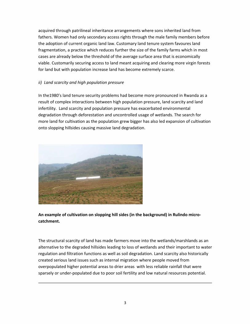
ii) Land scarcity and high population pressure
In the1980’s land tenure security problems had become more pronounced in Rwanda as a
result of complex interactions between high population pressure, land scarcity and land
infertility. Land scarcity and population pressure has exacerbated environmental
degradation through deforestation and uncontrolled usage of wetlands. The search for
more land for cultivation as the population grew bigger has also led expansion of cultivation
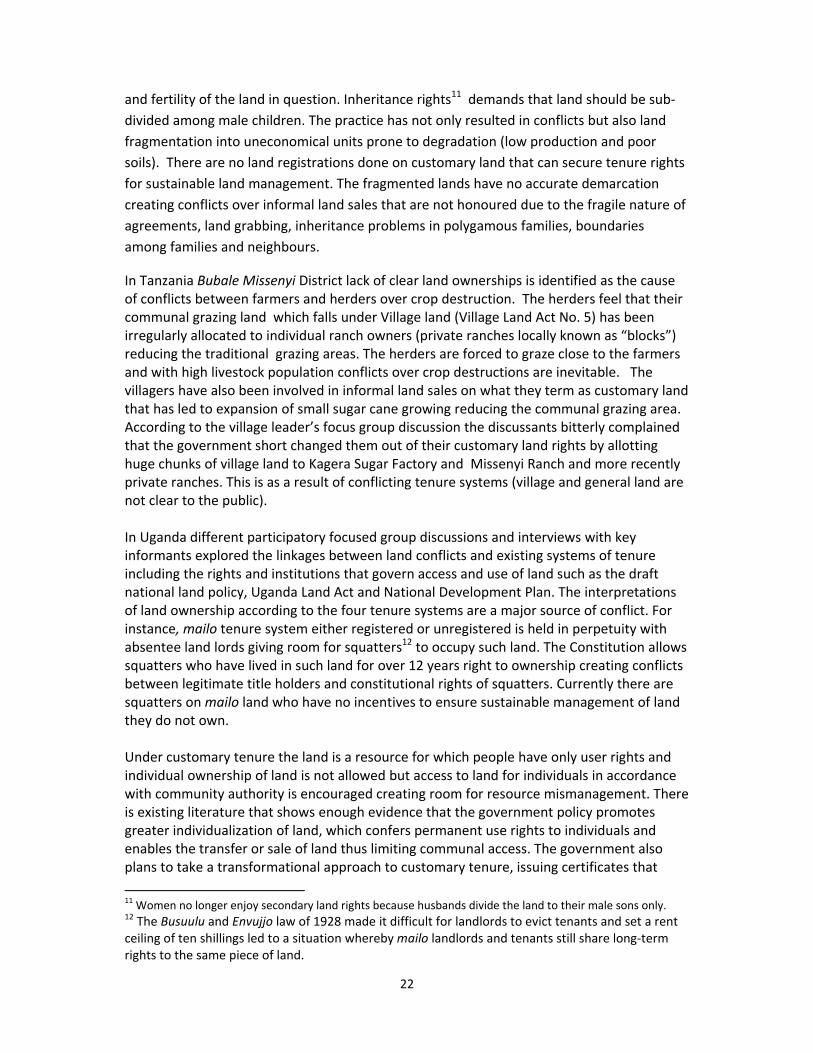
onto slopping hillsides causing massive land degradation.
An example of cultivation on slopping hill sides (in the background) in Rulindo micro‐
catchment.
The structural scarcity of land has made farmers move into the wetlands/marshlands as an
alternative to the degraded hillsides leading to loss of wetlands and their important to water
regulation and filtration functions as well as soil degradation. Land scarcity also historically
created serious land issues such as internal migration where people moved from
overpopulated higher potential areas to drier areas with less reliable rainfall that were
sparsely or under‐populated due to poor soil fertility and low natural resources potential.
4
According to Rwandan Agricultural Survey (1984) an average area of a family cultivation plot
was reduced to 1.2 ha from 2 ha in 1960. These interactions further reduced access to land
because already there were existing regional inequalities concerning arable land per family
(HHs), ranging from less than 0.25 ha to 2 ha yet, 90% of the population practiced
agriculture.
The decline in land through infertility and overexploitation as a result of land scarcity has
exacerbated pressure and destruction of natural reserves, over cultivation, soil erosion, and
resource degradation and these processes have continued unabated2 resulting in low
agricultural productivity. Several strategies have been adopted by the population to
mitigate land scarcity such as agricultural intensification whereby farmers have reduced
fallow periods, use continuous cropping and switching, adopt labour intensive techniques,
and invest in land capital if they have the means.
iii) Resettlement of refugees and its impact of land tenure
In 1959 Rwanda experienced serious violence that led to the first outflow of refugees to
neighbouring countries that forever changed the governance and redistribution of land.
It’s informative to note, that at this point competition for land was already fierce in addition
to cycles of conflicts and population displacements. The Arusha Peace Accords stipulated that
the refugees were to return to Rwanda (Article 2 of the Protocol of the Arusha Peace Accord
between the Government of the Republic of Rwanda and the Rwandese Patriotic Front on the
Repatriation of Rwandan Refugees and the Resettlement of Displaced Persons stated
that…”every returnee is free to settle in any area of his/her choice in the country, as long as
he/she does not infringe on somebody else’s rights”). Article 3 of the Protocol stated that “in
order to resettle the repatriated persons, the Government of Rwanda should release all
unoccupied land so identified by the Repatriation Commission”. On the other hand, Article 4 of
the Protocol stipulated that “the right to property is a fundamental right for all Rwandans”.
In reality the return of the 1959 refugees gave rise to a real land problem as returnees were
given plots on public land and vacant land on which they could resettle and produce (GoR 2004;
World Bank 1998). For instance, Umutara Game Reserve, two thirds of the Akagera National
Park and the Gishwati Mountain Forest, as well as land belonging to certain state‐owned
projects was parcelled out and distributed to the 1959 refugees(majority returned from
1998 onwards having been in displacement for decades). This included communal land,
woody areas found on good soil, pastures, and areas near the shallow sections of
marshlands. The resettlement seriously affected natural resources conservation in Rwanda.
In some provinces such as Kibungo, Cyangugu, Kigali Rural, Ruhengeri and Umutara, many
family plots were parcelled out and re‐distributed between the owners and the returning
2 Rwanda, with up to 80 percent of households in hilly areas dealing with a decline in productivity related to soil erosion has been a major issue of concern.
5
1959 refugees this created a great discontentment among the population that many
families are holding up to date.
6
iv) Policies and other legal instruments on land and other natural resources
The Government of Rwanda acknowledged the sensitivity and complex nature of land
problems such as, the landless, IDPs and refugees, land disputes and unequal distribution of
land (elites owning large chunks of land at the expense of the poor) that led to land tenure
reforms. The rigorous land reforms led to the adoption of a national land policy with a
series of land tenure reform practices at the centre. The land policy reform defined a new
legal framework and institutional arrangement through institutionalizing structures
governing the humankind relation to land by intervening in the prevailing land ownership,
control and usage.
Rwanda has one of the best policies, constitutional and legal frameworks relating to
gender, and particularly to women’s land rights. In the Organic Land Law 2005 (Chapters 3
& 4 on Management Organization and Exploitation of Land) Rwanda has undertaken
significant steps in the development of effective land administration system as a
prerequisite for land tenure security for all Rwandans and reinforces a legal environment
that recognizes landholders’ rights and provides to the holders the possibility for registering
and transferring their rights, over land, including the redistribution of land for landless.
Furthermore, it clarifies inheritance process and intends to solve the prevalent land
conflicts resulting from the traditional practices of exclusion which was practiced towards
the aforementioned vulnerable categories of Rwandans3. The 2004 Land Policy basically provides that:
i) all Rwandans will enjoy the same rights of access to land
ii) all land should be registered for security and titles that are tradable unless it
fragments a plot to less than 1 ha
iii) land use should be optimal
iv) consolidation of household plots is encouraged to ensure that each holding is not
less than 1 ha
v) land administration is to be based on a reformed cadastral (registered title deeds)
system
vi) a system of land administration is to be developed
vii) Marshlands are in the state’s private domain and are to be allocated to individuals
on concession by the Ministry of Lands (MINITERE) on condition of good
management.
The Land Law was gazetted in August 2005. Most elements of the Land Law support the
same argument as the Land Policy and further specify
3 3 Government of Rwanda, MINITERE, 2007; MINIRENA, 2008
7
i) all land has to be registered
ii) land consolidation is encouraged and will be approved by the minister
responsible for agriculture in conjunction with local authorities
iii) land has to be protected and conserved
iv) monitoring of land use is assigned to land commissions whereas registration is
assigned to land officers
v) failure to use, protect and conserve land properly can result in requisition or
confiscation
vi) land ownership is only provided through leases of up to 99 years
vii) marshlands remain state property
viii) transfer of title deeds requires prior consent of all family members
ix) there will be a land tax
x) Undeveloped land reverts to the state’s private domain after three years. In addition to the national land policy Rwanda has developed Master Plan for land
allocation, land use and land development and has established, National Land and
Geographical Information Centre that includes land registry and land‐use planning.
These are aimed at reducing conflicts and improving on sustainable land
management.
Others include National Environment Policy (2003) that stipulates the utilization of natural
resources and the protection and rational management of ecosystems for sustainable and
fair development. National Strategy and Action Plan for the Conservation of Biodiversity
(2003) that stipulates development of national strategies, plans or programs for the
conservation and sustainable use of biological diversity. It integrates the conservation and
sustainable use of biological diversity into relevant sectoral and cross‐sectoral plans,
programs and policies.
National Wildlife Policy (2007) that provides for mechanisms to protect wildlife, including
regulatory instruments for hunting and collection of specimens. Wildlife outside protected
areas is not explicitly provided for. National Forestry Policy (2004) which has established
Provincial Forest Commission to promote and oversee forestry activities those meet, on a
sustainable basis, the populations.
8
Burundi
Geographically, Burundi is located between Tanzania, the Democratic Republic of the Congo
(DRC) and Rwanda. It occupies a high plateau divided by several deep valleys with a total
area of 27,830Km2 out of which land cover is 25, 649 Km2 . Burundi has 8.6 million
habitants, with 300 inhabitants per km2. More than three‐quarters of the country’s
population live in the rural areas and depends on farmland for their food and other
livelihoods opportunities.
i) Land tenure systems
Historically, Burundi like Rwanda has experienced several phases of ethnic related conflicts
in 1972, 1988, 1993 and 2005, causing massive displacements of population into Tanzania,
the Democratic Republic of the Congo (DRC), Rwanda and other neighbouring countries.
Currently, several areas engrossed at the heart of today’s questions over land ownership,
are those who fled the violence in 1972 and are returning and wanting to reclaim their
original homes.
Burundi still embraces plural land tenure systems, customary and statutory. Statutory law is
prevalent in urban areas and customary law practised among the rural population. Faced
with two parallel tenure systems there are various challenges regarding land tenure security
and management of other natural resources. Under customary land tenure, land resource is
still hereditary from fathers to sons. Women have secondary user rights through male
relatives. It is important to note that polygamy types of marriages are still recognized
customarily in Burundi rural areas in particular creating several inheritance land conflicts.
Customary land tenure system land is still owned as a communal/common property
resource and people have lived with it for a long time and therefore, understand how it
works more than statutory tenure system.
Customary land tenure system in Burundi makes it difficult to resolve land use conflicts and
environmentally generates little personal interest in the status of land resources
management ("the tragedy of the commons") leading to mismanagement and degradation.
From focus group discussions informants agreed that previously, when human population
were low, the environment could absorb the impacts of human activities such as
unsustainable agricultural practices i.e “slash and burn” and long term fallowing. It now
appears that the mismanagement and degradation are rampant and the assimilative
capacity of Burundi’s environment under customary tenure is exceeded in several areas
visited such as Mwaro, Gitega, Kirundo among others.
9
ii) Population density and intensive deforestation
The Burundi population has tremendously increased, in 1960s it was 3 million currently
estimated at 8 million and is projected at 14 million in 2014 yet, the land size remains the
same. Because of dense population there is heavy pressure on land leading to intensive
land fragmentation within families (customary demands all male children inherit land from
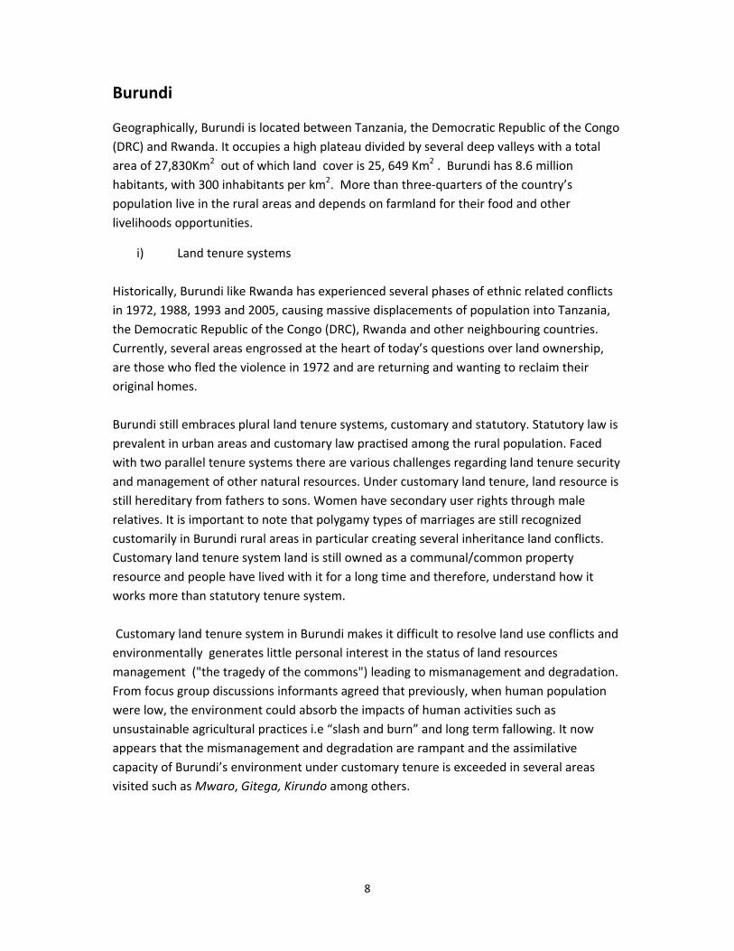
their fathers). Land fragmentation (as seen below) has been impacting on soil fertility and
severe land degradation including erosion and the wetlands have become alternative land
for agriculture to accommodate ever increasing populations. It is important to take note
that Burundi is a signatory to the Ramsar Convention on wetlands.4
Land fragmentation, Gitega Cultivated Marshland, Karusi
In the 1970s5 places such Kayanza and Ngozi were already facing serious population
pressure forcing the then government to transfer/move the people to Kirundo which at that
time was sparsely populated and agriculturally suitable for sorghum production. Today,
Kirundo is one of the most heavily populated Provinces with families encroaching into
Muhere Forest for settlements, farming and grazing activities.
Over 90 percent of Burundi’s working population is directly tied to the land for their
livelihoods through agriculture, yet the land is no longer able to provide an adequate yield
for these families. Thus, with an average of 0.5‐0.7 hectare per household the rising
population density continue to reduce the possibility of access to land and continue to
contribute to the steady fragmentation of farmland. The result has been overexploitation,
high levels of soil degradation and weak agricultural productivity further increasing the
number of land disputes among families.
4 According to the Ramsar convention on wetlands widespread degradation and loss is triggered by development projects, land conversion and deforestation. 5 Interview with the Director of Green Belt Movement
10
Burundi is facing widespread deforestation from exploitation for firewood, charcoal, brick
making (exporting to Rwanda) and construction materials, rapidly degrading the remaining
natural forests and the biodiversity dependent upon those ecosystems, as well as
diminishing water supplies for many populations. In Mwaro and parts of Gitega Provinces
deforestation is so severe along the steep slopes exposing the hills to further soil erosion
down the streams and water quality. The discussants in Gitega and Mwaro also highlighted
that erosion of the topsoil contributes to the fertility of the marshlands, so we follow the soil
downstream it is not completely “lost” to the agricultural system.
Burundi ‘ population pressure and demands for land by returning refugees are even adding
many other problems caused by land scarcity, dysfunctional land administration systems,
unclear inheritance rights and long standing problems of illegal allocation of public land.
There are general difficulties to guarantee tenure security to facilitate proof of land rights.
Land registration procedures are complicated, long and expensive.
iii) Internally Displaced Persons and Refugees
Following Burundi’ peaceful political settlements of the civil war, Arusha Peace and
Reconciliation Agreement(2000) and the CNND‐FDD coming to power the country has
another challenge created by large number of returnees of refugees and internally
displaced peoples with severe land tenure insecurity. Article IV of the peace accord
guarantees returnees access to their property, or adequate compensation, and recognises
the need for the equitable apportionment and redistribution of national resources
throughout the country. However, demands for land or compensation by returning refugees
are adding to many other problems caused by land scarcity, dysfunctional land
administration system, unclear inheritance rights and long standing problems of illegal
allocation of public land. It’s informative to note, that several rights are granted to the
State, under the categories of “public domain” which is inalienable and “private domain”
which can be conceded to private entities by public officials. Navigable water bodies, flood
plains, and areas designated specifically for protection (e.g. national parks and forest
reserves) are considered the State’s private domain. However the State public domain is
much broader, and includes “vacant” lands, land expropriated for reasons of public utility,
confiscated lands, non‐navigable water bodies (including marshes and wetlands), and
forests.
During the conflict the government resettled the internally displaced peoples in the land in
and around urban centres’ which either belonged to the government or refugees who fled
the country. After the war the IDPs are not willing to vacate such land (they want to retain
their new homes) at the same time, not willing to relocate to their original homes /land. The
refugees on the other side have failed to repose or secure their land and property either
from the government and IDPs.
11
For the IDPs and refugees access to land is seen as the only meaningful access to socio‐
economic rights, but also as a symbol of re‐assertion of national identity in a context in
which, historically access to rights and in particular, the right of access to land has often
been contingent upon ethnic allegiance. The ability of refugees to reassert claims over land
is not only a source of economic empowerment, but also an important indicator of
reintegration and the reinstatement of active citizenship and inclusion.
Burundi is facing general difficulties to guarantee tenure security and facilitate the proof of
land rights, land registration procedures are complicated, long and expensive for refugees.
It’s important to note that the government has adopted short and long term mechanisms to
address land problems among returnees and the ever increasing population but land
reforms are still far from solving Burundi’ problems. The government strategy of
establishing peace villages for the land less notably, the sans reference refugees who were
returning from neighbouring countries and “villagization programmes” commonly known as
paysannat are not sustainable given the fact that no guarantee on security of tenure exists
in terms of ownership, access, dispose and transfer rights over such land. The peace villages
are not seen as providing long lasting solution for neither reclaiming land lost to
government and corporations nor offering the opportunity for reintegration into the social
fabric of Burundi society and citizenry.6 Instead, they are fostering feelings of injustice and
resentment that do not portend well for Burundi's efforts to rebuild society and persuade its
citizens to return home.
iv) Access to land by the Batwa minority
Traditionally, the Batwa ethnic group use land for gathering and hunting but their rights
legally are not recognized and not protected as those of farmers and herders. They are
vulnerable and marginalized with no legal land use recognition and protection.
Their land has been converted into protected areas such as Muhere forest exposing them
to unsustainable survival means such poaching and deforestation (cutting trees for wood
fuel and charcoal burning).
v) Land policies and other legal instruments
Burundi has a well‐developed Land Policy (Lettre de Politique Fonciere) adopted in 2009. In
2011 the land policy was revised and promulgated in April 2011. The new Land code (2011)
6 Two people can’t share the same pair of shoes neither really profit since it becomes useless(Returnee, Temporary hosting site, Bukemba, July, 2009)
12
initiated as Presidential Decree in 2012 led to the creation of a National Land Commission.
Burundi also has other codes related to natural resources such as, the Environment Code
(2000), Water Code (2012) and Forest code (1986). According to the revised Land Code
(April, 2011) land tenure reform is one of the components the government is adopting to
improve food security and general development. The new Land Code has factored in gender
equality and inheritance rights issues on land unlike customary land rights.
Land registration for instance, is encouraged by the government to address land conflicts
and improve land use. Land reforms are being implemented for instance, the National
Commission on Land supported by Swiss Agency for Development and Cooperation (SDC
Land Tenure Sécurisation foncière) in 2007 launched a pilot project to help upgrade the
existing services of the cadastres, land titles, planning and training of the staff. The program
supports the National Commission on Land and other property in its work of inventorying
and delimitation of lands in the pilot communes7 (currently the pilot has undertaken land
registration in 14 communes that have received registration certificates).
Burundi does not have a policy document on environment although there is a piece of
legislation on environment which was enacted in 2000. Environment Code, Act No. 1/010 of
June, 2000 Loi No. 1/010 Portant Code de l’Environnement de la République du Burundi)
Environmental Code. This is a relatively recent legislation compared to the environmental
legal frameworks applicable in other Partner States like Uganda which was enacted in
1995. Like any other environmental legislation, this law is fairly comprehensive covering
almost all aspects of environmental and natural resources management, such as,
environmental principles, management of forests, energy, water resources, soil erosion and
land use, desertification, public inquiry/participation, management of wetlands, wildlife,
legal institutions
Law No. 1/6 of 3 Parc national (National Park) and Reserve naturelle (Nature Reserve)(1980)
Activities for which prior permission is necessary include entry for visitors, felling of trees
(under supervision of a forester), and capture of animals for scientific purposes and fishing.
Réserve forestière (Forest Reserve)—relevant legislation is Law (1980). The objectives of the
reserves are to maintain soil on mountains and slopes, to prevent erosion and to maintain
the ecological equilibrium for the benefit of the population and for the conservation of plant
or animal species recognized to be in within.
7 Strengthening capacity of the government on land management by bringing the results of its pilot project in the national debate, the Program supports the Government in finalizing and communicating new legislation in preparation: Policy Land Letter, Land Code, rules and regulations. It also supports the necessary coordination efforts between ministries and the civil society as well as the coordination of all land related activities through
a coordination unit available to the Ministry of Planning;
13
Uganda
Bordering Tanzania, Rwanda and Democratic Republic of Congo (DRC) Uganda covers a total
area of 199.807.4 km2 according to the Uganda Bureau of Statistics (2011). Its population
density has increased from 123 persons per km2 in 2002 to an estimated 165 persons per
km2 in 2011. Over half of Ugandan households consider agriculture to be the single most important source of their livelihood and as such, land is a critical resource for the 42 percent
of households that earn a living from subsistence farming (Uganda Bureau of Statistics,
2010; 2011). Taken together land is of critical importance to many Ugandans, especially
considering that 85 percent of the rural population depend on it for their livelihoods and
income.
i) Land tenure systems
All land in Uganda rests in the citizens of Uganda according to the Constitution (Ugandan
Constitution, 1985) and is owned with customary, freehold, mailo and leasehold tenure
systems. The Land Act of Uganda (1998) recognizes the four tenure systems. Customary land
tenure system is the most common tenure system in Uganda in the western part of the
country alone it comprises 47% of total land holdings (Republic of Uganda, 2010).
Customary tenure system access to land is “governed” by the customs, rules, and
regulations of the community.” Holders of land under the customary system do not have a
formal title to the land they use, but generally have secure tenure.
Customary land is owned and disposed of in accordance with patrilineal customs and
traditions. Women have no equal rights over land they only possess secondary ownership
through male members of the family. According to customary tenure regulations individual
ownership of land is not recognized but does the rights of the individual to possess and use
land subject to superintendency by his family, clan or community. In practice customary
tenure are categorized either as communal/tribal tenure where ownership of land occupied
by the community or tribe is vested in the paramount tribal leader as owner, who holds it in
trust for the entire group, or clan/family tenure where land is vested in the head of the
group as owner or trustee for the entire group.
Historically, Mailo land tenure system was introduced as a result of the 1900 Buganda
Agreement. Under this agreement, 9000 sq. miles of land were divided between the King
(Kabaka), other notables and the Protectorate government.8 Mailo tenure is a quasi‐
freehold tenure system established to reward colonial agents who advanced British
interests in many regions of Uganda. It remains a relatively secure and well‐defined system
of tenure, particularly in the Central region comprising of 99% (Republic Uganda, 2011). An
8 The basic unit of sub division was a square mile, hence the name mailo.
14
important feature of mailo systems is that much of the land is used by tenants who are
restricted in their security of tenure on the land they farm There are two types of mailo
namely; unregistered freehold mailo comprising of 71,331 Km2 and registered freehold
mailo comprising of 15,331Km2 and leased 31,769 km2. They could not be subdivided or
sold but passed intact from original office holder to his successor. In private mailo, the
owner held rights in the land akin to those of freehold and could dispose of land as he
wished. Under this system land is held in perpetuity and a certificate of title is issued. The
principal advantage of this system is that it still provides security of tenure thus allowing
long term developments including those related to conservation.
Freehold tenure is a system whereby owners of the land have a title to their land which
allows them to hold the registered land indefinitely. The landowner is given complete rights
to use, sell, lease, transfer, subdivide, mortgage and bequeath the land as they see fit, so
long as it is done in a manner consistent with the laws of Uganda. Just like mailo freehold
has similar environmental management problems. Due to population pressures in some
parts of Uganda where freehold tenure exists, land fragmentation is a common occurrence.
Land fragmentation is further contributing to significant environmental degradation.
Leasehold tenure is a system where the owner of the land grants the tenant exclusive use of
the land, usually for a specific period of time. Land may also be leased from the state to
individuals for typical lease periods of five, 45, or 99 years. In return, the tenant usually
pays an annual rent or service under specified terms and conditions. Leaseholders may or
may not hold formal contracts with the owner. There are two types of leasehold tenure
agreements, private leases given to individual landlords and official or statutory leases given
to individuals and or corporate groups under public act terms. The advantage of the
leasehold system is that the lessor can attach conditions to leases and has the right to
revoke ownership in case of abuse.
ii) Land rights
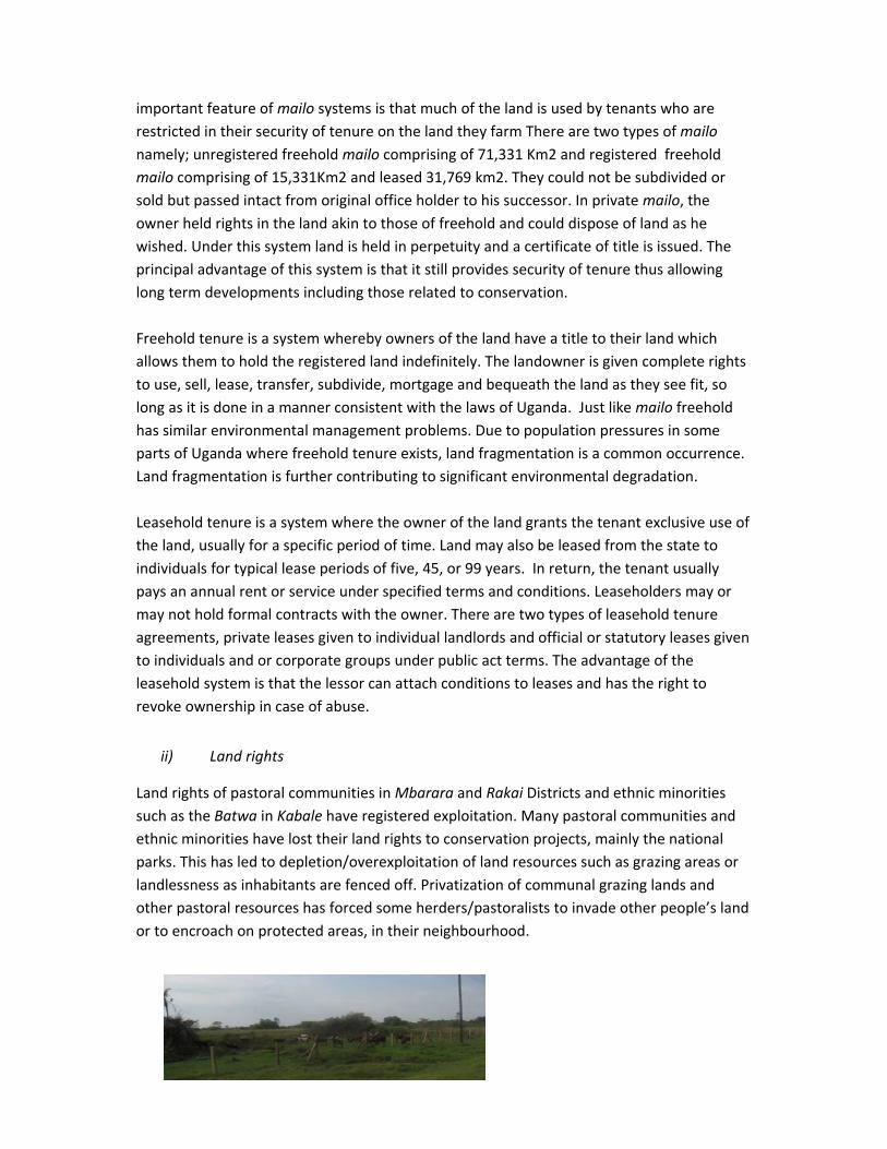
Land rights of pastoral communities in Mbarara and Rakai Districts and ethnic minorities
such as the Batwa in Kabale have registered exploitation. Many pastoral communities and
ethnic minorities have lost their land rights to conservation projects, mainly the national
parks. This has led to depletion/overexploitation of land resources such as grazing areas or
landlessness as inhabitants are fenced off. Privatization of communal grazing lands and
other pastoral resources has forced some herders/pastoralists to invade other people’s land
or to encroach on protected areas, in their neighbourhood.
15
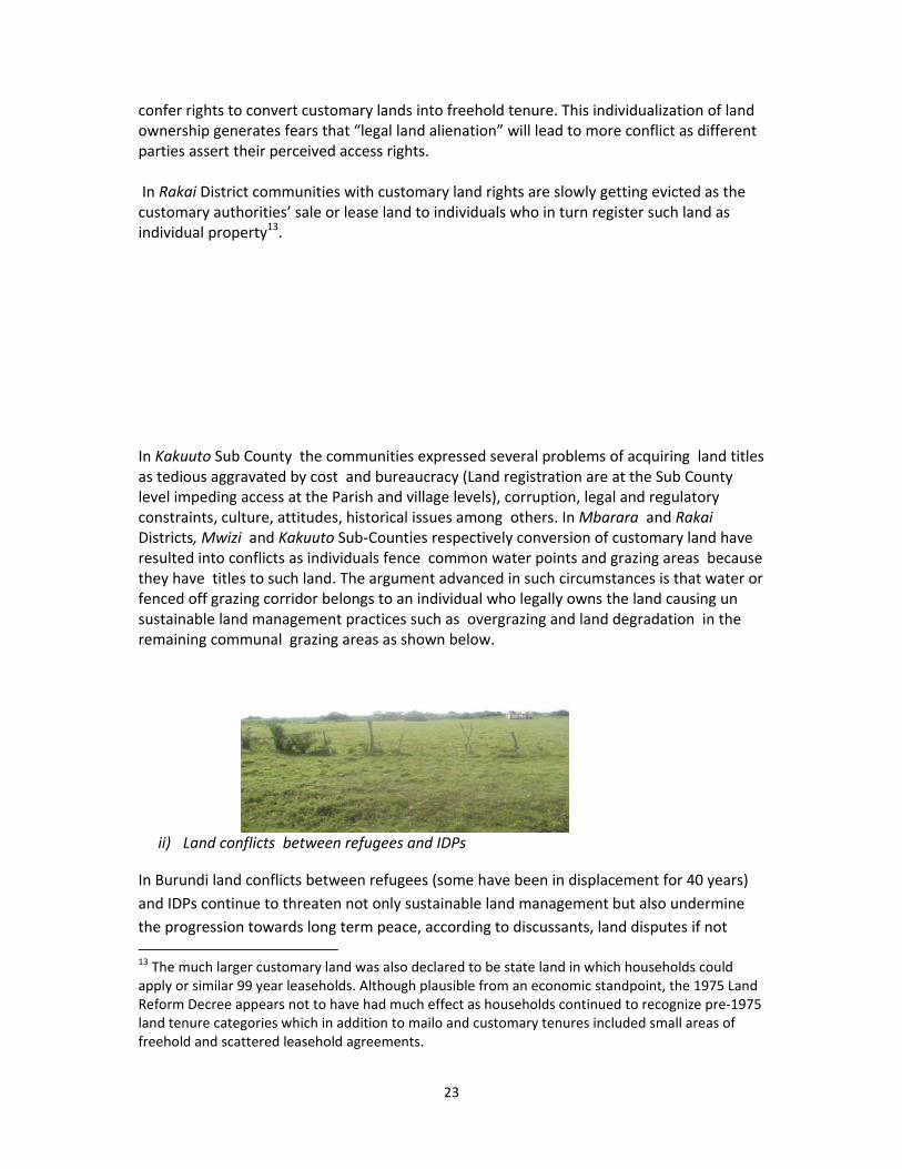
Examples of fenced off communal
grazing areas in Rakai Kakuuto
Sub/county
iii) Population pressure and land degradation
Population pressure and land degradation are ushering in land tenure changes that if left
uncoordinated will create serious land related problems further underscoring the urgency
for land use planning. The major source of land degradation in South West Uganda is
deforestation, soil mining, land and soil burning for brick making and wetland
encroachment. Land degradation continues to be a great cost to the quality of land
resources within Kagera Basin in Uganda mostly in the highlands and the cattle corridors. It
is estimated, for example, that land deterioration accounts for over 80% of the annual costs
of environmental damage, a situation the country can hardly afford. In addition, land
reserved for conservation purposes continues to pose challenges as regards, biodiversity
protection and heritage preservation.
Demands exerted by population growth and settlement expansion have placed wildlife
resources, catchment areas, forests and wetlands at risk despite the existence of legislation
on these issues. In some areas, especially Kabale District, the fragmented nature of land
ownership further complicates the process of converting customary land into freehold. In
addition to the above noted costs, the costs of surveying small, scattered plots easily
accumulate and become prohibitive.
iv) Policies and legal instruments on resources
Uganda got a draft National Land Policy (1995) and has no laws to operationalize it. There is
the Land Act (1998) and the National Land use policy (2007) that should have been based on
the land policy. Currently, Uganda has no national land use plan although the legal
provisions for its existence are provided for in the National Physical Planning Act (2010).
Absence of a national land policy to guide a review of the existing land laws on land
administration and management makes land resource issues complicated. 9
9 The Centre for Land Economy & Rights of Women 2005 on Land Policies in Sub Saharan Africa.
16
It is important to note, that Uganda has drafted Land Act (1998) and Land Sector Strategic
Plan (LSSP), Local Government Act (1997) and Forest Policy (2001). Other legislatives
include, Wildlife Policy (1995), The Water Statute (1995), The National Policy for
conservation and management of Wetland Resources (1995), The Uganda Wildlife Statute
(1996), National Environment Policy (1994),Uganda Wildlife Authority(1996), National
Environmental Management Authority (1995), Uganda Forest Policy and Forest Reserve
Order(1998).
17
Tanzania
Tanzania is in the East Africa Coastline of Indian Ocean. To the north are Uganda and Kenya
to the west, Burundi, Rwanda and Congo and to the south, Mozambique, Zambia, and
Malawi. Tanzania contains three of Africa's best‐known lakes Victoria in the north,
Tanganyika in the west and Nyasa in the south. Mount Kilimanjaro in the north, 19,340 ft
(5,895 m) the highest point on the continent. Tanzania has a total land area of 886,039Km
with a population (2010 est) 41,892,895. It also holds the greatest amount of River Kagera
waters.
Land in Tanzania is public vested in the Presidency. Access to land is through inheritance,
gifts, allocation by the government village or central or through purchase/markets.
i) History of land tenure system The introduction of centralized administration during the colonial era had weakened the
traditional land tenure arrangements and practices in Tanzania that defined common
property rights. Before colonialism, most land was common property resource, and was
owned and utilized by members of well‐defined groups, such as a tribe, the inhabitants of
one village, a family or a clan. Management of these resources was governed by traditional
or customary law. Under the colonial rule The Land Ordinance of 1923 defined and
regulated land tenure in Tanganyika, declaring all land occupied and unoccupied as public
land. The control and adjudication of such land was vested in the Colonial Governor.
In reality land tenure systems in Tanzania are still defined and regulated by the Land
Ordinance of 1923 albeit several revisions of the laws. The entire body of land in Tanzania
has been declared `public lands.' Rights over the land are under the control and direction of
the President of the United Republic and those rights cannot be disposed of without the
consent of the President. The President has radical title to all land in Tanzania and under the
Ordinance, must ensure that the land is held and administered for the use and common
benefit of Tanzanian natives.
The 1923 Land Ordinance introduced two main categories of land tenure. The Granted Right
of Occupancy, in which land title certificates were issued by the state to the land owner; and
The Customary Right of Occupancy to most natives without title deed. The Ordinance
provided that wherever there is a conflict between the two types of land ownership, the
granted right will prevail. A native individual or community lawfully occupying land in
accordance with native law and custom is deemed to have a "Right of Occupancy." It is
worth noting, that currently, clans/tribes in Tanzania have been “deprived of ultimate”
control and title to land. Such control and title are still vested in the President. Village land,
the individual/family/groups get allocated to are all based on derivative rights.
18
ii) Formal and legal context of land tenure systems
The legal basis for land tenure in Tanzania is derived from two basic laws that were passed
in 1999. The Land Act and the Village Land Act state that, all land in Tanzania is public land,
which the president holds in trust for all citizens. The president delegates the power to
designate, adjudicate and modify land tenure status to the Commissioner for Lands. District
and village councils play an important role in managing land at the local level. These two
laws have the overall objective of formalizing and legalizing traditional and customary land
tenure arrangements. Tanzania recognizes three categories of land Reserve, village and
general land.
Reserved land is land set aside by central government for purposes such as nature
conservation, under wildlife or forestry laws. It includes forest reserves, wildlife reserves
and national parks. Management of these areas is defined by the parent law (e.g forest
reserves are managed according to the Forest Act).
Village land includes all land within the boundaries of registered villages, of which there are
more than 10, 500. Village councils and assemblies are given power to manage this land.
The village Land Act of 1999 allows village government to enter into agreements and
enterprises that provide well‐being for villagers. Village councils are required to divide
village land into three categories: communal land, which is shared by a large number of
individuals within the village and may include grazing, pastures, forests or other areas with
natural resources; occupied land, which is used for housing, cultivation, businesses, etc. and
managed by individuals or single families and future land, which is set aside for future use
by individuals of the community.
General land is, land that is neither reserved nor village land. It is managed by
the Commissioner of Lands, on behalf of the central government.
iii) National Land policy and tenure systems
The Tanzania’s National Land Policy of 1995 provides that existing rights are recognized through long
standing occupation or use of land and must be clarified and secured by the law. The Land Act,
1999 states that A Customary Right of Occupancy is in every respect of equal status and effect to a
granted Right of Occupancy.’ The proviso continues to clarify that the Customary Right of Occupancy is
capable of being allocated by Village Council to person/persons and that it can be within Village land or
reserved land; for an indefinite duration. Such land shall be governed by customary law in respect of any
dealings, between persons residing in or occupying or using the land. It is inheritable and transmissible by will
and finally it is liable, subject to prompt and fair compensation, to acquisition by the State for public purpose.
19
The Village Land Act No. 5 of 1999 provides for the management and administration of land
entrusted to the village leader, which is to be directed by the Village Council. The crux of the
matter is that the management and administration must be in compliance with the
customary law of the respective area. Village Councils have no idea or hand‐on experience with the
customary law of the land they are administering. The customary law is unwritten and largely depends on
tell‐tales from elders. The Law provides for existence of the customary right of occupancy in village, its
existence as its founding customary law is either non‐existent or continuously being diluted and polarized by
the infiltration of intermarriages, migrations and urbanization. Those who own and occupy land under the
Customary Right of Occupancy are themselves not aware of the laws that govern their occupation.
Autochthonous land tenure is not recognized in Tanzania laws and one can safely conclude that the
alternative to the seemingly customary right of occupancy is not covered by law and at worst can be illegal.
Among the major issues aimed at being addressed by the 1995 Land Policy is to give equal
status to granted right of occupancy and customary right of occupancy. The Village Land Act
of 1999 provides for registration and issuance of Certificates of Customary Rights of
Occupancy (CCROs) as a measure of land security enhancement in rural Tanzania. The Act
stipulates the procedures to be followed so as to get CCRO. One of the important
procedures is adjudication of parcels of land of applicants. The Law offers methods of
adjudication namely Spot or Sporadic adjudication and Village or Systematic Adjudication.
iv) Land Registration and Land information.
Most land in Tanzania are not registered/ documented or mapped. Registration of land
in rural areas under customary land only is a source of conflict because there is no
existing land information. Data are scattered in the Ministry of Lands, Local Government
Authorities and Village Councils. There is no coherent system for collection, storage and
retrieval of land information.
v) Population pressure
TAMP Kagera Districts are located in the north‐western parts of Tanzania are some of
densely populated areas (500‐1250 persons per km2 of cultivated land) exerting a lot of
pressure on land and other natural resources. Agriculture is the sole means of economic
production and farm holdings are mostly smaller than a hectare and continue to
fragment as population continues to grow.
vi) Policies and legal instruments
Tanzania has got a National Land Policy enacted in 1995 and was amended in 1997, Land Act
no.4 and village land act no 5 enacted in 1999 and three more laws (enacted in 2007) on
Land Use Plan Act, Town and Country Planning Act, Planners Registration Board Act. Under
the Land Dispute Courts Act No.2 of 2002 and Regulations G.N. 174 of 2003, Land Tribunals,
2004.

20
Other policy instruments are The Forest Act (2002) Village land forest reserves (VLFRs).
These are a new category of forests, which became legalized following approval of Forest
Act No. 14 of 2002, Wildlife Conservation Act 2009 and Wildlife Policy of Tanzania (2007),
Tanzania and Wildlife Policy (1998). Tanzania Environment Management Act (2004)
21
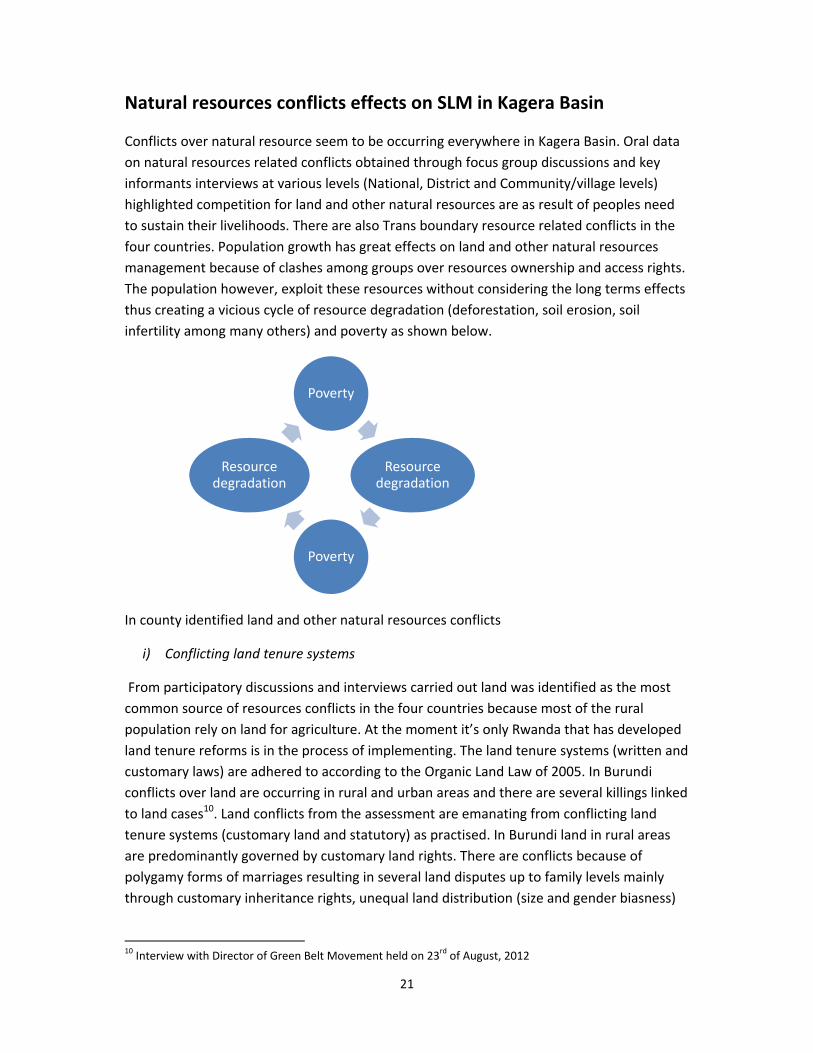
Natural resources conflicts effects on SLM in Kagera Basin
Conflicts over natural resource seem to be occurring everywhere in Kagera Basin. Oral data
on natural resources related conflicts obtained through focus group discussions and key
informants interviews at various levels (National, District and Community/village levels)
highlighted competition for land and other natural resources are as result of peoples need
to sustain their livelihoods. There are also Trans boundary resource related conflicts in the
four countries. Population growth has great effects on land and other natural resources
management because of clashes among groups over resources ownership and access rights.
The population however, exploit these resources without considering the long terms effects
thus creating a vicious cycle of resource degradation (deforestation, soil erosion, soil
infertility among many others) and poverty as shown below.
In county identified land and other natural resources conflicts
i) Conflicting land tenure systems
From participatory discussions and interviews carried out land was identified as the most
common source of resources conflicts in the four countries because most of the rural
population rely on land for agriculture. At the moment it’s only Rwanda that has developed
land tenure reforms is in the process of implementing. The land tenure systems (written and
customary laws) are adhered to according to the Organic Land Law of 2005. In Burundi
conflicts over land are occurring in rural and urban areas and there are several killings linked
to land cases10. Land conflicts from the assessment are emanating from conflicting land
tenure systems (customary land and statutory) as practised. In Burundi land in rural areas
are predominantly governed by customary land rights. There are conflicts because of
polygamy forms of marriages resulting in several land disputes up to family levels mainly
through customary inheritance rights, unequal land distribution (size and gender biasness)
10 Interview with Director of Green Belt Movement held on 23
rd of August, 2012
Poverty
Resource degradation
Poverty
Resource degradation
22
and fertility of the land in question. Inheritance rights11 demands that land should be sub‐
divided among male children. The practice has not only resulted in conflicts but also land
fragmentation into uneconomical units prone to degradation (low production and poor
soils). There are no land registrations done on customary land that can secure tenure rights
for sustainable land management. The fragmented lands have no accurate demarcation
creating conflicts over informal land sales that are not honoured due to the fragile nature of
agreements, land grabbing, inheritance problems in polygamous families, boundaries
among families and neighbours.
In Tanzania Bubale Missenyi District lack of clear land ownerships is identified as the cause of conflicts between farmers and herders over crop destruction. The herders feel that their communal grazing land which falls under Village land (Village Land Act No. 5) has been irregularly allocated to individual ranch owners (private ranches locally known as “blocks”) reducing the traditional grazing areas. The herders are forced to graze close to the farmers and with high livestock population conflicts over crop destructions are inevitable. The villagers have also been involved in informal land sales on what they term as customary land that has led to expansion of small sugar cane growing reducing the communal grazing area. According to the village leader’s focus group discussion the discussants bitterly complained that the government short changed them out of their customary land rights by allotting huge chunks of village land to Kagera Sugar Factory and Missenyi Ranch and more recently private ranches. This is as a result of conflicting tenure systems (village and general land are not clear to the public). In Uganda different participatory focused group discussions and interviews with key informants explored the linkages between land conflicts and existing systems of tenure including the rights and institutions that govern access and use of land such as the draft national land policy, Uganda Land Act and National Development Plan. The interpretations of land ownership according to the four tenure systems are a major source of conflict. For instance, mailo tenure system either registered or unregistered is held in perpetuity with absentee land lords giving room for squatters12 to occupy such land. The Constitution allows squatters who have lived in such land for over 12 years right to ownership creating conflicts between legitimate title holders and constitutional rights of squatters. Currently there are squatters on mailo land who have no incentives to ensure sustainable management of land they do not own. Under customary tenure the land is a resource for which people have only user rights and individual ownership of land is not allowed but access to land for individuals in accordance with community authority is encouraged creating room for resource mismanagement. There is existing literature that shows enough evidence that the government policy promotes greater individualization of land, which confers permanent use rights to individuals and enables the transfer or sale of land thus limiting communal access. The government also plans to take a transformational approach to customary tenure, issuing certificates that
11 Women no longer enjoy secondary land rights because husbands divide the land to their male sons only. 12 The Busuulu and Envujjo law of 1928 made it difficult for landlords to evict tenants and set a rent ceiling of ten shillings led to a situation whereby mailo landlords and tenants still share long‐term rights to the same piece of land.
23
confer rights to convert customary lands into freehold tenure. This individualization of land ownership generates fears that “legal land alienation” will lead to more conflict as different parties assert their perceived access rights. In Rakai District communities with customary land rights are slowly getting evicted as the customary authorities’ sale or lease land to individuals who in turn register such land as individual property13. In Kakuuto Sub County the communities expressed several problems of acquiring land titles as tedious aggravated by cost and bureaucracy (Land registration are at the Sub County level impeding access at the Parish and village levels), corruption, legal and regulatory constraints, culture, attitudes, historical issues among others. In Mbarara and Rakai Districts, Mwizi and Kakuuto Sub‐Counties respectively conversion of customary land have resulted into conflicts as individuals fence common water points and grazing areas because they have titles to such land. The argument advanced in such circumstances is that water or fenced off grazing corridor belongs to an individual who legally owns the land causing un sustainable land management practices such as overgrazing and land degradation in the remaining communal grazing areas as shown below.
ii) Land conflicts between refugees and IDPs
In Burundi land conflicts between refugees (some have been in displacement for 40 years)
and IDPs continue to threaten not only sustainable land management but also undermine
the progression towards long term peace, according to discussants, land disputes if not
13 The much larger customary land was also declared to be state land in which households could apply or similar 99 year leaseholds. Although plausible from an economic standpoint, the 1975 Land Reform Decree appears not to have had much effect as households continued to recognize pre‐1975 land tenure categories which in addition to mailo and customary tenures included small areas of freehold and scattered leasehold agreements.
24
addressed may cause renewed conflicts. Many refugees have not been able to reclaim their
land and property, especially in cases where their land is occupied and the current
inhabitants are unwilling to leave. The Land Code of 1986 grants ownership to land for those
IDPs who have occupied the land for up to 30 years. According to CNTB property
(Commission Nationale des Terres et Autres Biens) the refugees win such cases and
recommendations are made to revert the land but the IDPs use judicial institutions they
often find that the ruling is not in their favour (some of the current occupants have titles to
such land).
The CNTB has no legal mechanisms to affect the ruling a loop hole that IDPs take advantage
of by taking judicial process to challenge their rulings. Even when the ruling is in their favour
they fear for their safety from retaliation by the current occupants particularly, when the
land occupant is a powerful army officer or an influential person. With no access to land
sustainable management becomes a big challenge for refugees whereas IDPS enjoy the
privilege of using their old farms (original homes) as well as the “occupied land”.
Some IDPS bought land and are encouraged by the government to share with returning
refugees creating frictions between them because refugee households are bigger in size
(some HHs have 17 male adults) leading to severe land fragmentation. Besides, it creates
bitterness from IDPs who genuinely bought land with own resources either from the
relatives of those who fled or neighbours who remained behind14. Such insecurity of tenure
between refugees and IDPs results into unsustainable land management. It is important to
note, that already there is land shortage leading to competition in these areas the result is
that more conflicts among the IDPs and refuges land users.
Burundi’ vulnerable groups are even in more fragile situation because they cannot reclaim
their land from the current occupants, at the same time, have limited options with regard to
accessing alternative land. The focus group discussions held in Kirundo Province highlighted
that population pressure has made it extremely impossible for customary land rights to
offer equality to all. The conflict resolution mechanisms handling resource disputes are so
corrupted that people loose land to those with money. For instance, the women returnees,
orphans, the Batwa minority and a group of refugees15 referred to as “sans reference” are
the worst hit. A female discussant “explained you must give the ink for the village elders’
pen to write”. Genuine land owners are denied access to their land leading to further land
degradation in small plots already faced with poor soils.
Rwanda has successfully integrated the refugees and IDPs through its land reforms. For
instance, the main objective of the national land Policy was to establish a land tenure
system that guarantees tenure security for all Rwandans and guides land reform initiatives
14 According to the Director Global Rights ;“it’s not a Hutu –Tutsi conflict as perceived my many but
it’s between Hutus and Hutus and also Tutsi and Tutsi 15 According to UNHCR the category constituted approximately 10% of the returning 1972 refugees to Burundi.
25
that will establish good management and the rational use of land. Rwanda land policy is
aimed at ensuring equitable allocation of land ownership, enhancing the land rights and
improving access to land for disadvantaged people through legal and administrative acts.
iii) Land conflicts between the State and individuals/ community
The other conflict related to land is between the government and the communities. In Tanzania the genera land (owned by the government) and village Lands are not demarcated leading to land grabbing of State land by individuals. In Missenyi, Karagwe and Bukoba Districts discussants complained of village land and general land being converted illegally to individuals through land sales. Altering the right of occupancy to claims as stated in the Land Act no. 4 and Village Land Act no. 5 creating conflicts between the State and individuals/communities. In Burundi refugees whose land had been taken through concessions, appropriated or allocated for public use under unclear circumstances particularly are at conflict with the government. The Burundian Batwa have been marginalized by the government in terms of offering alternative livelihood opportunities from the forest. They occupy one hundred metres stretch of forest land in Muhere Forest with no alternative land for farming. They turn to unsustainable exploitation of the forest resources. Their population is also growing with time which means the government need to address their land rights in the long term. In Uganda the Batwa minority ethnic groups in Kabale feel that their traditional land was converted to National Parks without getting alternative settlements and forms of livelihoods from the government. The Batwa are hunter‐ gatherers their forests have been converted into conservation sites. They are landless, marginalized and despised by the Bachiga16 farmers because they cannot produce own food leave alone applying sustainable land management a response from one informer.17
iv) Encroachment into State forests, national reserves and game parks, wetlands and water sources
There are incidences of human, wildlife conflicts among communities bordering forests, national and game parks due to encroachment. Wildlife habitats have been disturbed and wildlife migration corridors blocked through human activities such as deforestation, farming and grazing in the forests. In Karagwe District Rumanyika Rugudu Game reserve is an example where rhinos and monkeys destroy crops planted close by the buffer areas. The discussants argue that the buffer zone is not demarcated that is why farmers cultivate in the forest a fact disputed by the Wildlife Officers. Illegal poaching and bush fires are prevalent but are unsustainable means of resource exploitation adopted by the communities.
Encroachment to government forests and wetlands/swamps in Burundi and Uganda is a source of land conflicts between State conservation apparatus and the community. Muhere forest in Burundi is threatened by overgrazing and population settling beyond the buffer
16 Bachiga are Bantu spearing community occupying SW and Western parts of Uganda 17 Interview with the Director of African International Christian Ministry held on the 4
th of Sept, 2012 at
Kaabale.
26
zone. Human activities continue to threaten the environment and wildlife conservation areas with further encroachment of protected forests. Unsustainable agricultural practices (bush burning, cultivation of ecologically sensitive areas such as hilly or sloping areas, forests and wetlands without paying attention to establishment of soil erosion control.
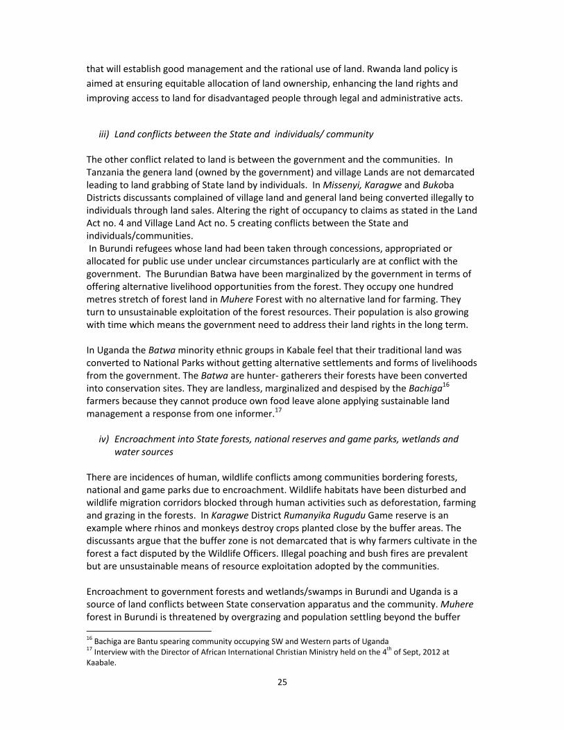
In Uganda National Forest Authority (FNA) exists in paper but on the ground government forests have been turned into grazing land, exposed to bushfires, deforestation (charcoal burning and wood fuel. In Mwizi Sub –County the Focus group discussions highlighted how communal grazing areas no longer exist but people have livestock the only grazing option we have is the government forest. (As photographed seen below)
27
Animals grazing in a government forest in Mwizi Sub‐County, Mbarara District.
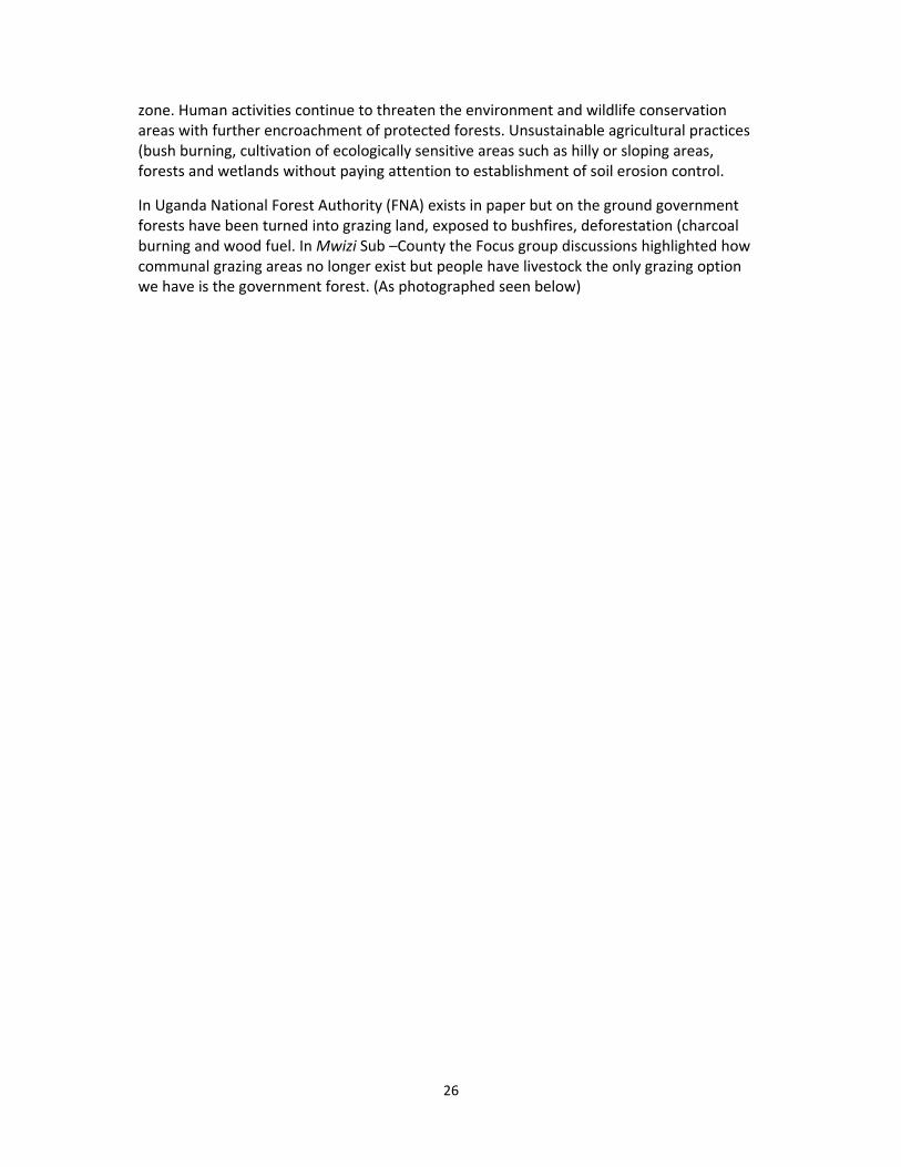
Wetlands/swamps in Uganda, Tanzania (Ngara District close to River Ruvubu) and Burundi are not respected as conservation areas but have been slowly turned into agricultural farm land, settlement, dairy farming, grazing areas, brick making, sand mining and clay extraction. In Uganda project sites wetlands that can be cultivated or grazed on are all occupied by the community despite the fact that, wetlands are declared protected ecosystems and habitats of species of fauna and flora thereby excluding or limiting human activities. Exclaims and environment officer in Kabale “we have policies according to NEMA Uganda that clearly states, that the management of river banks and lakes shores, the Authority in consultation with lead agency shall take all measures it considers necessary in order to protect the banks of rivers and shores of lakes from human activities that will adversely affect the rivers and the lakes”. There are political interferences over wetland encroachment despite policies, laws and by –laws. “Wetlands do not vote” was one of the recorded statements in Kabale District Uganda. Below is brick making less than 10 metres in Ruvubu River, Ngara District. On the left is wetland in use in Rakai District
v) Farmers and herders because of the absence or non enforcement of land use plans at the local levels
There is also as strong link between natural resources utilization and natural resource
competition and conflicts in Kagera Basin. There are in country conflicts over land uses that
rise when farmers and herder groups use resources differently in the same geographical
location. Rwanda has developed a land use plan and has managed to reduce resource
28
conflicts between herders and farmers. Tanzania has developed village land use plans in
some villages in the Districts (not all) of Bukoba Missenyi and Ngara. However enforcement
remains elusive for instance in Karagwe District (Katera and Kihanga villages), in Uganda
Bubale Sub‐county (Kitumba and Bubale village) farmers and herders are constantly at
conflict because of land scarcity. Farmers are extending farming activities to communal
grazing areas and herders encroaching farming land creating conflicts over crop destruction
or blocked animal corridors.
In Karagwe farmers are encroaching designated traditional communal grazing areas leading
to massive land degradation. The attachment to land by farmers and herders impede
sustainable land management. For instance, in Bubale village Bubale Sub‐County in Uganda
the herders rejected the construction of terraces to reduce soil erosion in degraded grazing
areas because they believed the farmers would eventual claim that piece of land.
Over grazing is a big problem in Uganda coupled with poor compliance of policies, laws,
regulations and by‐laws. Hilly and mountains have been fragmented and are at risk of
further environmental degradation i.e they are prone to soil erosion, landslides, vegetation
cover have been removed or is likely to be removed from the area at a faster rate than it is
being replaced and other land use activity that lead to environmental degradation are so
common. In Kituma Kabale District farmers are faced with massive land degradation
because of cultivating on the hilly and mountainous areas but are not willing to protect the
soil through terracing (“fanya‐ chini fanya‐ juu”) method because it would take part of their
land.18
vi) Water conflicts
Water scarcity was mentioned among discussants in Rwanda Rulindo micro‐catchment.
Particularly, during dry season when capacity of natural water sources from the mountains
are reduced. In Burundi focus group discussion in Kirundo highlighted that water conflicts
are prevalent during dry seasons when farmers irrigating farms upstream consumes huge
volumes creating shortages for those downstream. Water conflicts in Uganda and Tanzania
according to the discussants are as result of blocked or fenced off watering sources causing
congestion. Kagera Sugar Factory has blocked access to River Kagera local villages in Bubale
areas.
vii) Conflicting government policies/laws/regulations and Acts on natural resources
18 Land scarcity is already a big problem in Kabale because of high population land is fragmented and each
person want to retain that land at all cost.
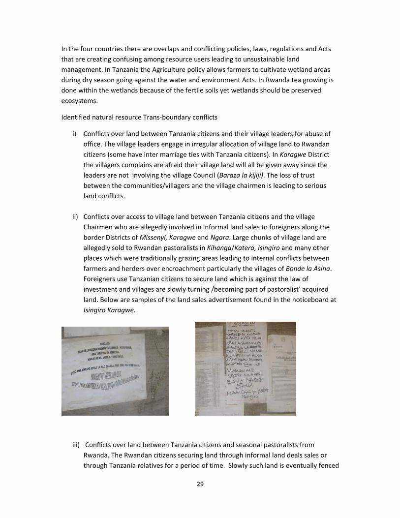
29
In the four countries there are overlaps and conflicting policies, laws, regulations and Acts
that are creating confusing among resource users leading to unsustainable land
management. In Tanzania the Agriculture policy allows farmers to cultivate wetland areas
during dry season going against the water and environment Acts. In Rwanda tea growing is
done within the wetlands because of the fertile soils yet wetlands should be preserved
ecosystems.
Identified natural resource Trans‐boundary conflicts
i) Conflicts over land between Tanzania citizens and their village leaders for abuse of
office. The village leaders engage in irregular allocation of village land to Rwandan
citizens (some have inter marriage ties with Tanzania citizens). In Karagwe District
the villagers complains are afraid their village land will all be given away since the
leaders are not involving the village Council (Baraza la kijiji). The loss of trust
between the communities/villagers and the village chairmen is leading to serious
land conflicts.
ii) Conflicts over access to village land between Tanzania citizens and the village
Chairmen who are allegedly involved in informal land sales to foreigners along the
border Districts of Missenyi, Karagwe and Ngara. Large chunks of village land are
allegedly sold to Rwandan pastoralists in Kihanga/Katera, Isingiro and many other
places which were traditionally grazing areas leading to internal conflicts between
farmers and herders over encroachment particularly the villages of Bonde la Asina.
Foreigners use Tanzanian citizens to secure land which is against the law of
investment and villages are slowly turning /becoming part of pastoralist’ acquired
land. Below are samples of the land sales advertisement found in the noticeboard at
Isingiro Karagwe.
iii) Conflicts over land between Tanzania citizens and seasonal pastoralists from
Rwanda. The Rwandan citizens securing land through informal land deals sales or
through Tanzania relatives for a period of time. Slowly such land is eventually fenced
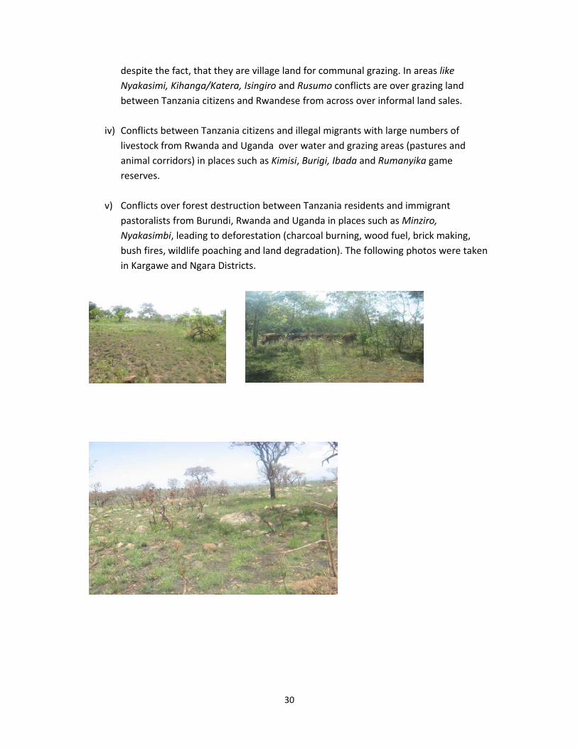
30
despite the fact, that they are village land for communal grazing. In areas like
Nyakasimi, Kihanga/Katera, Isingiro and Rusumo conflicts are over grazing land
between Tanzania citizens and Rwandese from across over informal land sales.
iv) Conflicts between Tanzania citizens and illegal migrants with large numbers of
livestock from Rwanda and Uganda over water and grazing areas (pastures and
animal corridors) in places such as Kimisi, Burigi, Ibada and Rumanyika game
reserves.
v) Conflicts over forest destruction between Tanzania residents and immigrant
pastoralists from Burundi, Rwanda and Uganda in places such as Minziro,
Nyakasimbi, leading to deforestation (charcoal burning, wood fuel, brick making,
bush fires, wildlife poaching and land degradation). The following photos were taken
in Kargawe and Ngara Districts.
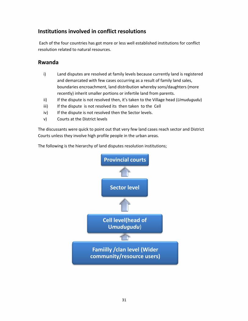
31
Institutions involved in conflict resolutions
Each of the four countries has got more or less well established institutions for conflict
resolution related to natural resources.
Rwanda
i) Land disputes are resolved at family levels because currently land is registered
and demarcated with few cases occurring as a result of family land sales,
boundaries encroachment, land distribution whereby sons/daughters (more
recently) inherit smaller portions or infertile land from parents.
ii) If the dispute is not resolved then, it’s taken to the Village head (Umudugudu)
iii) If the dispute is not resolved its then taken to the Cell
iv) If the dispute is not resolved then the Sector levels.
v) Courts at the District levels
The discussants were quick to point out that very few land cases reach sector and District
Courts unless they involve high profile people in the urban areas.
The following is the hierarchy of land disputes resolution institutions;
Provincial courts
Sector level
Cell level(head of Umudugudu)
Famiilly /clan level (Wider community/resource users)
32
Burundi
The most common source of conflicts emerges from land resource.
i) At the family/clan levels elders resolve land disputes/conflicts i.e land grabbing,
family land sales, boundary disputes, inheritance issues, polygamous marriages and
land distribution.
ii) When no agreement is reached the disputes are taken to the head of Nyumba Kumi
(Ten households)
iii) From the ten households the conflict is taken to the Collin (hill) levels. The
discussants were quick to comment that the Collins and Nyumba –Kumi are so
corrupt that justice is not guaranteed. The leaders require the” ink for their pens to
write” (a local version of describing corruption). Without the ink whether land is
customarily yours you will loose the case to the people with money. Returnees,
women and orphans are the worst affected because such type of leadership does
not accept justice systems. Several examples were given by the discussants that even
killings have happen because one has money the other has not. International NGOS
such as Global Rights handling disputes between refugees and IDPs or Local NGOs
(CARE) supports resource users address their conflicts in non‐violent means. Global
Rights’ Burundi has been involved at these levels in resolving land disputes among
refugees and those who occupied their land. Global Rights have established both
stationary and mobile clinics in Muyinga, Kirundo, and Ngozi provinces and
community paralegals have been trained.
iv) When the conflicts are not resolved at the Collin level the cases are moved to the Zone level
v) Courts at the commune level
The discussants quickened to say very few cases reach this level because of lack of access and affordability. Majority of rural population are not aware of the procedures, are poor and cannot afford the court charges. Courts are for the rich and educated peoples not for us exclaimed one woman in a focus group discussion in Mwaro. The wealthy people use courts to swindle the poor people of their land because they cannot represent themselves. Several times land cases are postponed purposely for the poor to give up. As it stands, Burundi’s courts have not been effective in resolving land disputes. Although 80 percent of the contentious cases in the country’s judicial system involve conflicts over land, few Burundians have confidence in court verdicts, fewer than half of which are ever enforced. And for most people, even flawed legal proceedings are too lengthy, complex, and expensive to pursue. It’s important to highlight that customary conflict resolution mechanism are applied at all
levels except at the government courts where statutory laws are used. Mediation as a form
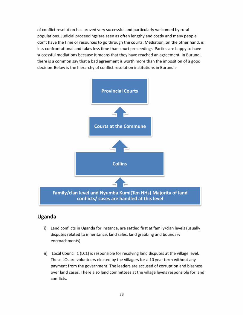
33
of conflict resolution has proved very successful and particularly welcomed by rural
populations. Judicial proceedings are seen as often lengthy and costly and many people
don’t have the time or resources to go through the courts. Mediation, on the other hand, is
less confrontational and takes less time than court proceedings. Parties are happy to have
successful mediations because it means that they have reached an agreement. In Burundi,
there is a common say that a bad agreement is worth more than the imposition of a good
decision. Below is the hierarchy of conflict resolution institutions in Burundi:‐
Uganda
i) Land conflicts in Uganda for instance, are settled first at family/clan levels (usually
disputes related to inheritance, land sales, land grabbing and boundary
encroachments).
ii) Local Council 1 (LC1) is responsible for resolving land disputes at the village level.
These LCs are volunteers elected by the villagers for a 10 year term without any
payment from the government. The leaders are accused of corruption and biasness
over land cases. There also land committees at the village levels responsible for land
conflicts.
Family/clan level and Nyumba Kumi(Ten HHs) Majority of land conflicts/ cases are handled at this level
Collins
Courts at the Commune
Provincial Courts
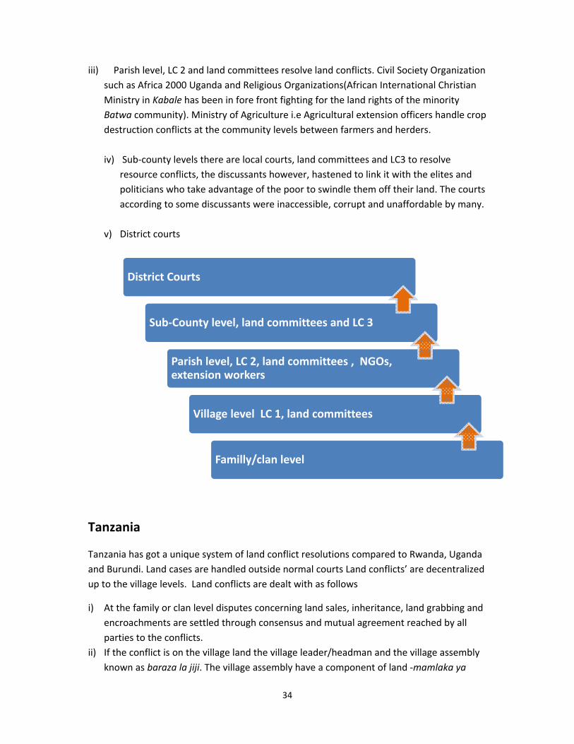
34
iii) Parish level, LC 2 and land committees resolve land conflicts. Civil Society Organization
such as Africa 2000 Uganda and Religious Organizations(African International Christian
Ministry in Kabale has been in fore front fighting for the land rights of the minority
Batwa community). Ministry of Agriculture i.e Agricultural extension officers handle crop
destruction conflicts at the community levels between farmers and herders.
iv) Sub‐county levels there are local courts, land committees and LC3 to resolve
resource conflicts, the discussants however, hastened to link it with the elites and
politicians who take advantage of the poor to swindle them off their land. The courts
according to some discussants were inaccessible, corrupt and unaffordable by many.
v) District courts
Tanzania
Tanzania has got a unique system of land conflict resolutions compared to Rwanda, Uganda
and Burundi. Land cases are handled outside normal courts Land conflicts’ are decentralized
up to the village levels. Land conflicts are dealt with as follows
i) At the family or clan level disputes concerning land sales, inheritance, land grabbing and
encroachments are settled through consensus and mutual agreement reached by all
parties to the conflicts.
ii) If the conflict is on the village land the village leader/headman and the village assembly
known as baraza la jiji. The village assembly have a component of land ‐mamlaka ya
District Courts
Sub‐County level, land committees and LC 3
Parish level, LC 2, land committees , NGOs, extension workers
Village level LC 1, land committees
Familly/clan level
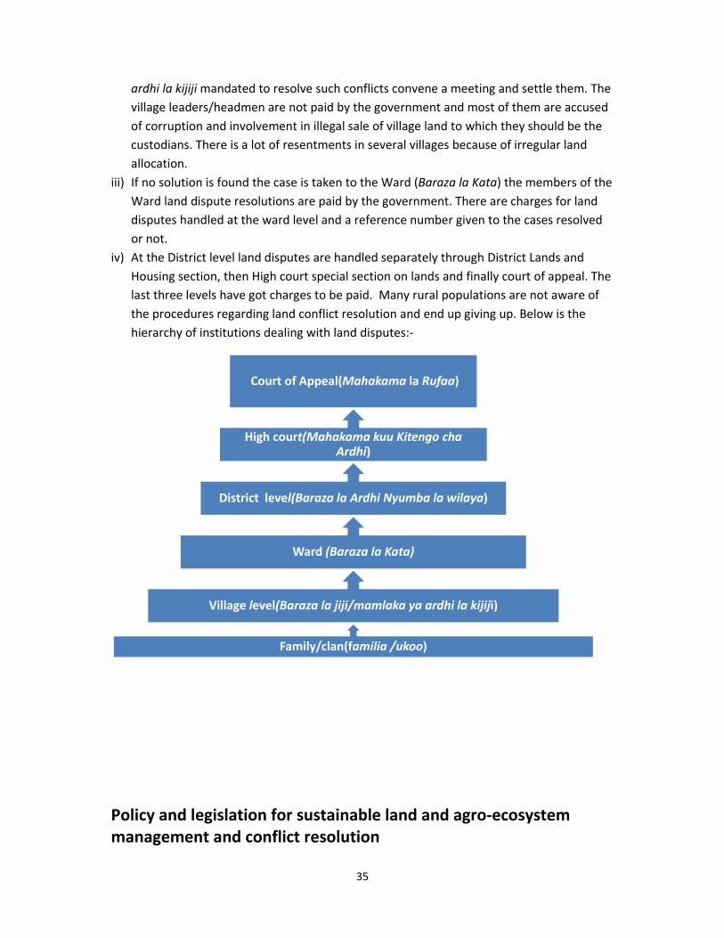
35
ardhi la kijiji mandated to resolve such conflicts convene a meeting and settle them. The
village leaders/headmen are not paid by the government and most of them are accused
of corruption and involvement in illegal sale of village land to which they should be the
custodians. There is a lot of resentments in several villages because of irregular land
allocation.
iii) If no solution is found the case is taken to the Ward (Baraza la Kata) the members of the
Ward land dispute resolutions are paid by the government. There are charges for land
disputes handled at the ward level and a reference number given to the cases resolved
or not.
iv) At the District level land disputes are handled separately through District Lands and
Housing section, then High court special section on lands and finally court of appeal. The
last three levels have got charges to be paid. Many rural populations are not aware of
the procedures regarding land conflict resolution and end up giving up. Below is the
hierarchy of institutions dealing with land disputes:‐
Policy and legislation for sustainable land and agro‐ecosystem management and conflict resolution
Family/clan(familia /ukoo)
Village level(Baraza la jiji/mamlaka ya ardhi la kijiji)
Ward (Baraza la Kata)
District level(Baraza la Ardhi Nyumba la wilaya)
High court(Mahakama kuu Kitengo cha Ardhi)
Court of Appeal(Mahakama la Rufaa)
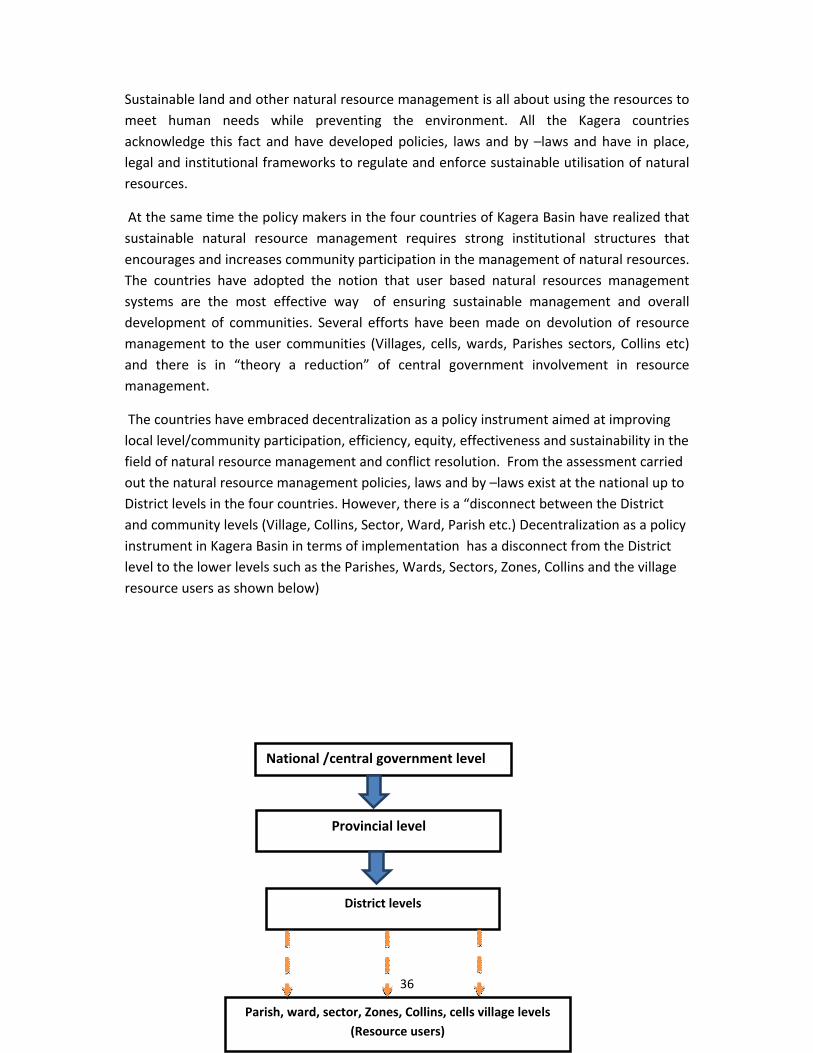
36
National /central government level
Provincial level
District levels
Parish, ward, sector, Zones, Collins, cells village levels
(Resource users)
Sustainable land and other natural resource management is all about using the resources to
meet human needs while preventing the environment. All the Kagera countries
acknowledge this fact and have developed policies, laws and by –laws and have in place,
legal and institutional frameworks to regulate and enforce sustainable utilisation of natural
resources.
At the same time the policy makers in the four countries of Kagera Basin have realized that
sustainable natural resource management requires strong institutional structures that
encourages and increases community participation in the management of natural resources.
The countries have adopted the notion that user based natural resources management
systems are the most effective way of ensuring sustainable management and overall
development of communities. Several efforts have been made on devolution of resource
management to the user communities (Villages, cells, wards, Parishes sectors, Collins etc)
and there is in “theory a reduction” of central government involvement in resource
management.
The countries have embraced decentralization as a policy instrument aimed at improving
local level/community participation, efficiency, equity, effectiveness and sustainability in the
field of natural resource management and conflict resolution. From the assessment carried
out the natural resource management policies, laws and by –laws exist at the national up to
District levels in the four countries. However, there is a “disconnect between the District
and community levels (Village, Collins, Sector, Ward, Parish etc.) Decentralization as a policy
instrument in Kagera Basin in terms of implementation has a disconnect from the District
level to the lower levels such as the Parishes, Wards, Sectors, Zones, Collins and the village
resource users as shown below)
37
The decentralization as a policy instrument from the discussions held on the ground still falls
short of infrastructures for successful implementation of policies, laws and regulations on
sustainable utilization of available natural resources effectively among the resources users
and resolve conflicts at the lower/grassroots’ levels. The gap between the national level, the
District, extension service providers and people on the ground is so wide.
Weak and ineffective institutions to effect natural resource management policies/laws and
regulation at the lower levels have created more resource conflicts. Which in reality means
policies, laws/regulation and by‐laws exist but no enforcement mechanisms in place and
stiffer penalties on those who do not oblige leading to resource conflicts. The policies, laws
and regulations and by‐laws do not take root at the community levels or among resources
users leading to overexploitation, degradation and conflicts.
In Tanzania for instance, The Village Land Act no. 5 (1999) does not allow the Village
chairmen (legal custodians of village land) to allocate more than 50 acres of land to an
individual, and that land must be approved by the Village assembly exist but it’s not
followed. The Village chairmen are accused of breaching such laws by allocating large
chunks of land to individuals and irregular land sales creating land conflicts between the
villages and individuals who purchase such lands. In Burundi the policies/laws and
regulations are written in French not Kirundi prohibiting the local communities access of
information because very few people read at the village levels.
The communities are not fully aware or sensitized on such policies and the consequences. In
Tanzania they have village committees that should closely work with the District authorities
to ensure sustainable use of resources but they are not motivated (no incentives from the
government) or rewarded by the government on conservation issues. The communities turn
blind eyes on environment al issues.
Technical personnel at the District levels such as governance and administrators working
with natural resources forests, land and environment are not aware of some of the policies
and laws they should implement. At the same time, conflicting policies on natural resources
creates more confusion and laxity in terms of implementation at the village levels. In
38
Burundi the right to ownership of marshlands which occupy about 20 percent of the country
is contradictory. Traditionally marshland belonged to public land but there are no current
legal provisions to safe guard the issue. Marshlands have become smallholder farming units
and are privately owned creating conflicts between the communities and public authorities.
The Land policy (2009) clearly stated that marshlands are privately owned but the
administrators are not aware.
Different government departments of natural resources lack functional implementation
strategies on policies among user communities/grassroots because of lack of funds (lack of
prioritization of natural resources ministries) and human resources. For instance, in
Tanzania each District has only one forest officer who reports directly to the Executive
Director whose priority is not conservation issues. Other issues mentioned include;
Allegations of corruption and ineffective government officials and village leaders
(local councils and village chairmen) at the village levels to enforce policies, laws and
by‐laws).
Lack of incentives from the government for the communities living close to forests
reserves to fully engage and promote participatory sustainable utilization of natural
resources. Communities look at the forests as government’ property and in the
absence of forest officers they overexploit the resources. In Tanzania brick making
activities along River Ruvubu occur at night when the villages use indigenous trees to
burn bricks which is not allowed by law.
Lack of alternative sources of energy impeding success on sustainable exploitation of
forest resources.
Lack of alternative income generating activities to ease the pressure on natural
resources particularly in areas already affected by severe land infertility. Poverty
makes us cut trees but we all know the government want us to plant more trees are
some of the comments from villagers.
Political interferences with natural resource management i,e wetlands are constant
sources of conflict between farmers/herders supported by politicians. Depending on
who (herders or farmers) voted them in the elections policies are bend to support
voters.
39
Lessons learned
i) Land and natural resources are politically sensitive in Kagera Basin which calls for
innovative and dynamic management tools at all levels to enhance multi‐
stakeholder participation and improve sustainable utilization of resources.
ii) Optimizing local level control over land and other natural resources with more
emphasis on gender –sensitive participatory mechanisms could improve access
and decision‐ making on resources for all.
iii) Land suitability maps and land use maps when developed and enforced can be
useful in solving land and natural resources conflicts as well in Kagera Basin.
iv) Communities are more enthusiastic on agro‐forestry activities i.e boundary
planting, woodlots, shed –tree planting, plating trees with crops more than
management of water resources. There is need to develop an integrated water
management tool to bring all stakeholders together to determine community
long term needs for water and other related natural resources in line with
climate change(maintaining essential ecological concerns and sustainable
agricultural practices)
v) More community participation in management of water resource at the basin
would enhance integrating land and water, upstream and downstream, ground
water and surface.
vi) Adopting government policies, laws and by‐laws regarding land and other natural
resources enhance sustainable utilization of resources and reduce conflicts
emanating from competition.
40
Framework for negotiation process for sustainable land and other natural resources management
From field visits, interviews and consultative meetings the reporting consultant proposed
a simple framework for negotiations to be experimented/piloted in Tanzania, Uganda,
Burundi and a joint/ trans boundary (Rwanda, Tanzania, Burundi and Uganda) to resolve
identified conflicts and improve sustainable management of natural resources. It’s
important to note; the framework is part of the recommendations made on TAMP Kagera as
an action point for country specific and transboundary project activities.
The framework proposes that TAMP Kagera should initiate country specific and trans
boundary (as stated below) negotiation and dialogue “pilot “processes among resource
users using Participatory Negotiation Territorial Development (PNTD)19 ( country specific
conflicts) and Welcoming Capacity( transboundary conflicts) approaches to address and
resolve land and other natural resources conflicts.
PNTD approach has been successfully adopted in negotiation on land and other natural
resources i.e migratory routes, grazing areas and water conflicts in Sudan ‐Darfur, on land
conflicts in Angola and Mozambique and, has demonstrated ability (FAO added value) to
support trust building process at local level whilst supporting higher level policy/legislative
mechanisms. PNTD currently is gaining international recognition as an important tool for
managing local resources and territorial development. It supports negotiated decision‐
making processes and encourages social dialogue and partnerships between the actors
within a given territory.
Using PNTD framework for negotiation should be adapted to address identified country
specific conflicts such as i) farmers and herders conflicts in Tanzania, Karagwe District
(Kihanga/Katera villages) ii) Land conflicts in Uganda, Kabale District (Kitumba and Bubale
villages) and, iii) Land conflicts in Burundi, Mwaro and Gitega Districts. The approach offers
participatory platform forums that address suspicion, mistrust and offer better
understanding of all the stakeholders/actors (parties) before embarking on dialogue, and
eventually reaching a consensus anchored on negotiation.
The framework begins with a comprehensive participatory territorial diagnosis of seeking
views, opinions, interests, positions and power imbalances of all the stakeholders (directly
and indirectly) involved in land and other natural resources conflicts. The territorial
diagnosis is then followed by horizon phase where dialogue processes on land and natural
resources and proposals for enhancing sustainable resource utilization are discussed.The
dialogue face opens up discussions among stakeholders/actors and starts from the
evidences and analysis provided by the participatory territorial diagnosis. Negotiation phase
is the final process in the framework where the stakeholders/actors have gained confidence,
19 http://www.fao.org/sd/dim_pe2/pe2_050402a1_en.htm
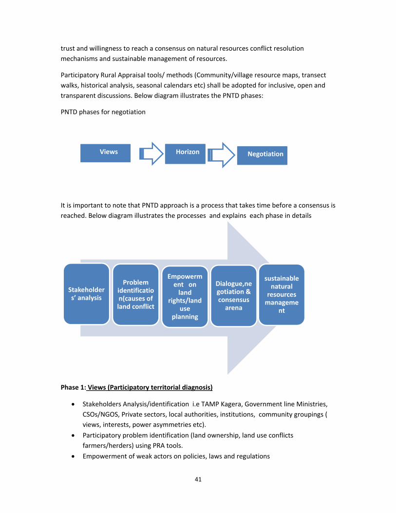
41
trust and willingness to reach a consensus on natural resources conflict resolution
mechanisms and sustainable management of resources.
Participatory Rural Appraisal tools/ methods (Community/village resource maps, transect
walks, historical analysis, seasonal calendars etc) shall be adopted for inclusive, open and
transparent discussions. Below diagram illustrates the PNTD phases:
PNTD phases for negotiation
It is important to note that PNTD approach is a process that takes time before a consensus is
reached. Below diagram illustrates the processes and explains each phase in details
Phase 1: Views (Participatory territorial diagnosis)
Stakeholders Analysis/identification i.e TAMP Kagera, Government line Ministries,
CSOs/NGOS, Private sectors, local authorities, institutions, community groupings (
views, interests, power asymmetries etc).
Participatory problem identification (land ownership, land use conflicts
farmers/herders) using PRA tools.
Empowerment of weak actors on policies, laws and regulations
Negotiation HorizonViews
Problem identification(causes of land conflict
Empowerment on land
rights/land use
planning
Dialogue,negotiation & consensus arena
sustainable natural resources manageme
nt
Stakeholders’ analysis
42
Trust and confidence building among stake holders
Phase 2: Horizon(dialogue)
Dialogue platform /arena is set to discuss land issues
“Win‐win” situation for all and a formal agreement is reached through consensus
Collaborative resource management for all stakeholders
Phase 3: Negotiation and consensus building
Trust and confidence building leading to joint decision making
Willingness to reach a consensus
On the other hand, trans boundary (Tanzania, Rwanda, Uganda and Burundi) land and
resource conflicts can be addressed using Welcoming Capacity approach. It is important to
note that for trans boundary conflicts participatory negotiations and dialogue processes can
go a long way;
i) establishing trust and confidence among resource users,
ii) ensuring seasonal or temporary access to resources through joint consensus
(through documented formal agreement) indicating period/time other resource
users can access resources i.e pastures,
iii) establishing terms and conditions of the agreement well stated with effective
monitoring systems in place.
WC approach is a shift of perspectives towards an inclusive address of conflicts emanating from natural resource by focusing on building of trust, dialogue and negotiations among “hosting communities” in this case Tanzanian citizens and “foreigners” from Rwandan, Ugandan and Burundi resource users. The main objective of adapting this approach is to promote an all‐inclusive (host communities and their neighbours/foreigners) negotiations processes and reach a consensus. For instance, how many pastoralists and the number of livestock should be welcomed or accepted to graze per Km2 in a particular area and under what conditions.
The WC approach provides practical introduction to systemic negotiation processes which
offer room for inclusion and recognition of all stakeholders /actors as equally important
and their engagement in all the on –goings trans boundary natural resource issues are very
crucial. The approach is a step towards changing perspectives from focusing on alternative
conflict resolutions mechanisms between the Tanzania hosts and their neighbours but offers
43
understanding of existing “gaps” that affects the social relationships20 as well (there is an
existing intricate socio‐cultural relationships and inter‐dependencies).
The WC approach will also improve awareness on transboundary policies, laws and
regulations i.e environment, water, wildlife and land tenure and their effects on sustainable
natural resource management and challenges facing resources users. Closely identify and
analyse what are the conflicting natural resources and territorial challenges? Who are the
“drivers” or what are the determinants? What are conditions? How can the condition be
improved? The WC approach will provide an opportunity to identify (with the view to
prevent) nascent differences or “low –key conflicts” from spilling over into violent
confrontations.
WC as a new negotiation approach is centred on problem resolution and has in recent
years, received much attention theoretically on collective negotiation approaches that
abandon the obsession for a ‘win‐win’ solution and instead emphasizes more on the process
rather than the outcome.
It is important to highlight that application of Welcoming Capacity as an approach also
adopts PNTD Phases as explained below;
Views Phase (Participatory Territorial Diagnosis)
The objective of this phase is to carry out a systemic trans boundary/ territorial diagnosis processes. Identification, examination and analysis of actors /stakeholders (direct and indirectly involved), what are their interests, potentials, constraints, opportunities and strengths? What are the roles and responsibilities of the stakeholders actors, (i.e important to understand hosting communities’ and foreigners) potentials, livelihood strategies, coping mechanisms, and inter‐ dependencies.
Examination of trans boundary institutions’ dealing with natural resources and establish what are the constraints, opportunities, and capabilities exist to resolve real and perceived conflicts related to natural resource management (competition over resources). What are the institutional gaps in enhancing resource conflicts?
Historical analysis that will provide a coherent understanding of communities’ social organization (social exclusion and vulnerabilities), livelihoods strategies, socio‐economic and historical events, land and land based resources rights and relationship within the productive chain. It is important to understand the history of land occupation and other natural resources exploitation (forests, water) and whether these rights existed for the Tanzania /hosting communities or not.
20 We have close social ties across the border including inter‐marriages how can we deny our in‐laws access to
grazing areas an informant exclaimed at Isingiro, Karagwe District
44
It’s important to note that historical analysis will offer a unique opportunity for examining and assessing land tenure arrangements and how they could contribute to other resource conflicts i.e water, grazing areas, forests and wildlife. Who determined these rights? What changes have taken place i.e migration, climate change and natural resource conflicts?
Horizons Phase (Dialogue and Proposals)
The objective of this phase is to open up discussions among stakeholders over trans boundary natural resource conflicts. The dialogue processes starts from the evidences and analysis provided by the first phase of participatory territorial diagnosis.
The dialogue processes will support the stakeholders in drawing up a coherent and feasible perspective for the future trans boundary conflicts resolution and sustainable natural resource management. For instance, once the stakeholders/actors have accepted the different views or areas of concerned in regard to conflicts and sustainable natural resource management, preconditions for dialogue met and concrete proposals (how to resolve trans boundary conflicts and proposed sustainable resource utilization) elaborated to meet specific needs of each stakeholder.
Dialogue will be based on a more careful understanding of the dynamics of underlying trans boundary conflicts (such as competing claims to resources) and significant involvement of all stakeholders/actors at all levels but more importantly that all efforts would contribute towards social and political stability particularly, at the grass‐roots levels.
Dialogue will offer reassurance to different stakeholders/actors of the necessity of long –term dividends of peace and that effective (internal and external) interventions are only possible when all sources of conflicts are recognized, the dynamics between them understood, decision‐making and peace building initiatives enhanced and inclusion (all actors involved should participate). Failure to involve all parties could lead to renewed resource conflicts.
It’s important to note that all the Governments and stakeholders/ actors must be open and actively involved in the dialogue processes, in order to identify lasting solutions for conflict resolution and natural resource management. And, stakeholders/actors’ willingness to participate in the dialogue processes are always related to their perceptions, experiences of the obstacles and limitations of such a process.
Negotiation Phase
The objective of this phase is to boost confidence building among trans boundary stakeholders/actors. Confidence building remains a prime activity in WC approach and is key to negotiation process.
Confidence and trust building will result in a joint/collaborative decision‐making processes which in many cases will often than not, influence the willingness to reach
45
a consensus on conflict resolution mechanisms and sustainable natural resources management.
A variety of PRA techniques will be adopted such as i) Historical analysis ii) Time Line iii) Venn diagrams to establish which institutions and key stakeholders/actors (direct and indirect) iv) Land use patterns (an essential element) investigated not simply in terms of current use, but in terms of the overall community land use systems iv) Transects to obtain a transversal slice of what a territory produces, where and how it creates trans boundary resource conflict.
46
Conclusion
Land remains the most important resource in the River Kagera Basin because the majority of the population rely on agriculture for subsistence living. In the four countries the discussants identified more with land other than, other natural resources such as water, forests, wildlife and wetlands. It is evident that the four Countries of Kagera Basin have different and unique in country and transboundary resource conflicts that affect SLM. Land ownership and land use remains a big challenge particularly, in rural areas There are institutions and policy frameworks to enforce sustainable management of land and other natural resources in the Basin however, there is a “missing link” between such institutions and resource users. The policies and legislation are like water hyacinth with no roots at the grassroots levels. The institutions lack the capacity and financial resources needed to roll out beyond District levels among other factors. As a way forward it is important to enforce policies, laws and by‐laws at the grassroots through adequate government funding of natural resources line ministries. The four governments should engage in creating more partnerships and close coordination with international organizations as means of improving access to land and other resources to reduce conflicts.
47
Recommendations/way forward (Narrative)
Strengthening policies and conflict resolution institutions
Strengthening public institutions is a huge task that TAMP Kagera project cannot achieve
independent of the four government’ strong support. Two ways are therefore, suggested
i) TAMP Kagera to engage the four States (National level) in prioritizing natural
resources line Ministries (Forests, Water, Wildlife, Environment and Land) as a
matter of great and urgent concern to development. Allocate sufficient
budget/funds to address the gap of lack of capacity (human and financial
support) to enforce/implement/monitor/evaluate policies, laws, regulations and
by‐laws up to the village levels.
ii) TAMP Kagera to form Action Groups (AG) in each country to address capacity
gaps on natural resources. Lack of capacity by the government officials is
adversely mentioned (from the District, Sub/counties, Wards, and Commune,
Collins, Zones, Parishes and Village levels) as a setback in undertaking core
functions of delivering efficiently and effectively. The Action Groups should
involve key stakeholders such as government representatives, natural resources
line Ministries, Private sectors, Civil Society Organization (NGOs & CBOs) and
individuals interested in conservation issues.
The Action Groups should have clear terms of references (TORS) and monitoring systems to
evaluate the progress made in terms of enforcement of policies, laws and regulations
regarding natural resources in the project sites.
The Action Group could as well engage in harmonizing conflicting in country policies/laws
and regulation and by‐laws on natural resources in collaboration with government line
Ministries.
Land suitability maps and land use maps
The four countries should develop land suitability and land use maps at the grass root levels
(villages) in a participatory manner to take into account the views of the villagers. This will
not only reduce resource conflicts but will quicken land registration process at the village
levels.
Training workshops
TAMP Kagera in collaboration with implementing partners in each country should engage on
training of government officials at the village levels on integrated policies/laws/regulations
and Acts on natural resources. This will help in formulating deliverable and achievable by‐
laws at the community. Each Country should conduct 3 days interactive workshop where
Senior government officials from the national level natural resource Line Ministries (Land,
48
Forest, Wildlife, Environment, Water, Immigrations etc) conduct training on what the
policies/laws/regulations are, enforcement mechanisms, procedures and penalties for
noncompliance. The workshop should come up with monitoring and reporting mechanisms
to ensure that sustainable natural resource management are adhered to and conflicts
resolve recorded.
Awareness creation and sensitization at the community levels
After training the government officials at the village level and implementing
partners/service providers will embark on awareness creation and sensitization meetings on
change of attitudes and behaviours on resource utilization and information sharing
regarding policies, laws and regulations, sustainable natural resources use and how to
reduce conflicts at the grass root levels. The awareness can also be channelled through
translation of policies in local languages and local vernacular radio programmes.
Empowerment of FFS and the community
The Farmer Fields Schools are doing great in the four countries but need to be empowered
on Reproductive Health (population control), natural resources policies/laws and
regulations, procedures on resource conflict resolution mechanisms, land use planning, land
registration issues should be factored in the curricular. TAMP Kagera could should pilot Land
and Property Rights using FFS approach to educate farmers (men and women) on land rights
and tenure security which is critical for sustainable land management and conflict resolution
The module has been tested in Kenya with and Mozambique with FFS and JFFLS respectively
(A comprehensive facilitators guide is already developed FAO).
Actions aimed at securing land tenure could go a long way in the management of land
resource as well help in sustainable resources utilization within the Basin where land
degradation is a major impediment to sustainable agriculture. Land registration for instance,
will not only reduce conflicts but encourage adoption of sustainable land management
practices with long term impact i.e afforestation, reforestation, rehabilitation of rangelands,
terracing and grass strips; hedge grows water and soil retention ditches and check dams
would help in the long term.
Alternative sources of livelihoods
The issue of alternative sources of livelihoods mainly off‐farm activities to ease the pressure
on land in the four countries. Burundi and Rwanda are the worst affected by severe land
fragmentation and high population density impacting on unsustainable resource utilization.
49
Trans boundary
Regional workshop
TAMP Kagera should organize a regional workshop where Trans boundary conflicts (illegal
migration of human and livestock, forest destruction and land issues) can be addressed
The workshop should address conflicting regional policies, laws and regulations that affect
sustainable resource management (charcoal burning and wood fuel/trade, brick making).
Establish trans boundary enforcement and monitoring mechanisms that would work better
in conflict resolution and promoting good neighbourhoods i.e effective trans boundary
conflict resolution committees. The existing District Defence and Security Committees are
comprised, ineffective and have no clear terms of references.
Policy harmonization within River Kagera Basin
Different countries policies are a threat to sustainable land management a policy
harmonization would result in joint enforcement mechanisms that would better. This can be
discussed at the EAC level. Already the treaty for the establishment of EAC in Article 112
calls for parties States to cooperate in all issues of Environment and Natural Resources
(ENR) Management. The treaty requires that the parties States cooperate to preserve,
protect and enhance the quality of environment and ensure sustainable utilization of shared
natural resources.
TAMP Kagera should engage in proper coordination and partnerships with others on natural
resources management such as Nile Basin Initiative, The Kagera River Basin Transboundary
Integrated Water Resources Development Project (TKTIWRDP).
Research on alternative sources of energy and building materials
Conservation and sustainable land management without alternative sources of energy is a
big challenge because majority of the population rely on wood fuel. Planting fast maturing
trees can be an alternative but must be coupled with intensive awareness creation and
sensitization at the local levels in each country.
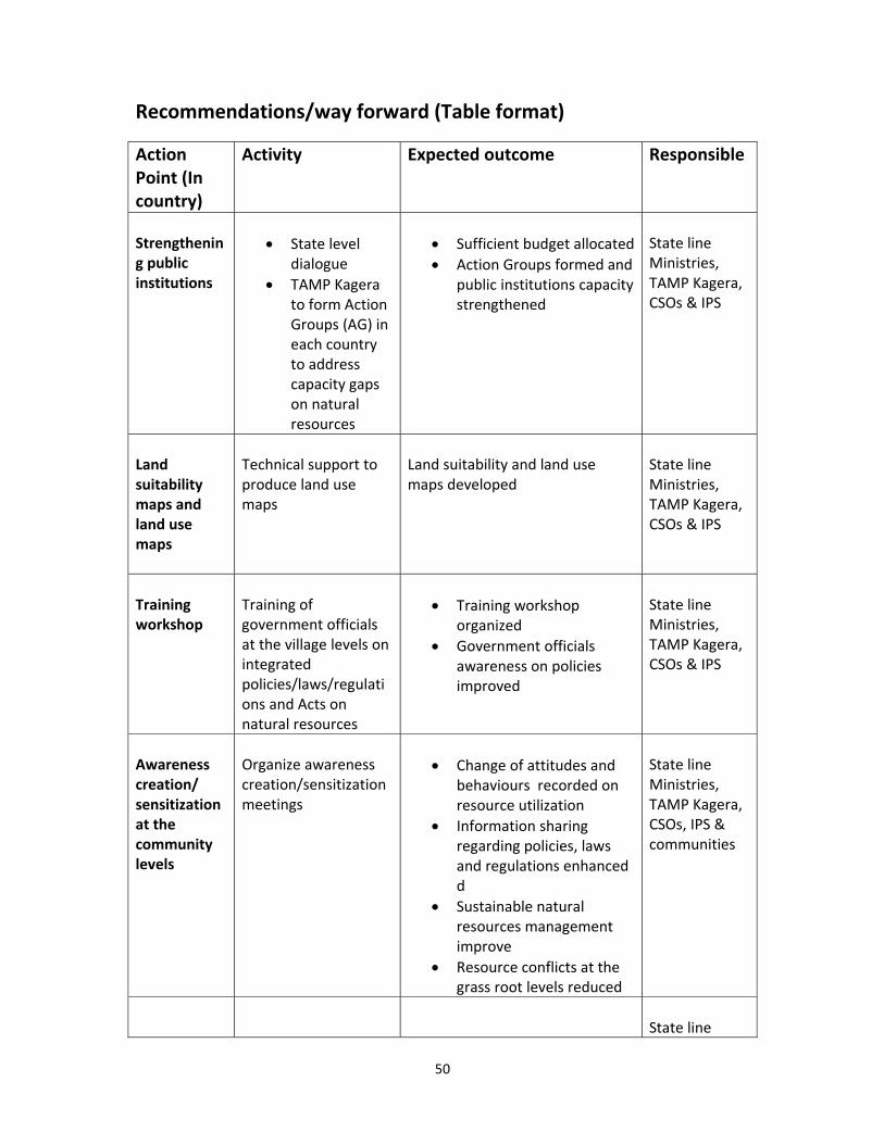
50
Recommendations/way forward (Table format)
Action Point (In country)
Activity Expected outcome Responsible
Strengthening public institutions
State level dialogue
TAMP Kagera to form Action Groups (AG) in each country to address capacity gaps on natural resources
Sufficient budget allocated
Action Groups formed and public institutions capacity strengthened
State line Ministries, TAMP Kagera, CSOs & IPS
Land suitability maps and land use maps
Technical support to produce land use maps
Land suitability and land use maps developed
State line Ministries, TAMP Kagera, CSOs & IPS
Training workshop
Training of government officials at the village levels on integrated policies/laws/regulations and Acts on natural resources
Training workshop organized
Government officials awareness on policies improved
State line Ministries, TAMP Kagera, CSOs & IPS
Awareness creation/ sensitization at the community levels
Organize awareness creation/sensitization meetings
Change of attitudes and behaviours recorded on resource utilization
Information sharing regarding policies, laws and regulations enhanced d
Sustainable natural resources management improve
Resource conflicts at the grass root levels reduced
State line Ministries, TAMP Kagera, CSOs, IPS & communities
State line
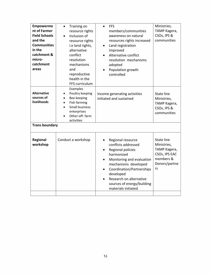
51
Empowerment of Farmer Field Schools and the Communities in the catchment & micro‐catchment areas
Training on resource rights
Inclusion of resource rights i.e land rights, alternative conflict resolution mechanisms and reproductive health in the FFS curriculum
FFS members/communities awareness on natural resources rights increased
Land registration improved
Alternative conflict resolution mechanisms adopted
Population growth controlled
Ministries, TAMP Kagera, CSOs, IPS & communities
Alternative sources of livelihoods
Examples
Poultry keeping
Bee keeping
Fish farming
Small business enterprises
Other off‐ farm activities
Income generating activities initiated and sustained
State line Ministries, TAMP Kagera, CSOs, IPS & communities
Trans boundary
Regional workshop
Conduct a workshop Regional resource
conflicts addressed
Regional policies harmonized
Monitoring and evaluation mechanisms developed
Coordination/Partnerships developed
Research on alternative sources of energy/building materials initiated
State line Ministries, TAMP Kagera, CSOs, IPS EAC members & Donors/partners

52
53
References
Arusha Peace and Reconciliation Agreement (2000).
Bigagaza, J. Abong, Mukarubuga ( 2003). Land Scarcity and conflict in Rwanda in Scarcity
and Surfeit. ACTS
Blarel, B. (2001) Tenure Security and agricultural production under land scarcity: The case
of Rwanda in J. & S Mighot‐Adhola. Searching for land tenure security in Africa.
Kendall/Hunt, Dubuque, USA
Bledsoe, D. (2004). Republic of Rwanda Land Policy and Law. Trip Report: Findings and
Recommendations. RDI/USAID/ MINITERE
Deininger, Klaus and Raffaella Castagnini (2006). “Incidence and impact of land conflict in Uganda.” Journal of Economic Behaviour & Organisation Environmental Legislation of Uganda Volume 1, (2004)
Fischer, M. (2004) Recovering from violent conflict: regeneration and (re‐)integration as elements of peacebuilding. Berlin, Berghof Research Center for Constructive Conflict Management Gasana, J.K. (1997). “Factors of ethnic conflict in Rwanda and instruments for a durable peace.”
Gasasira, E. (1995). Land issues after the war. Kigali. UNDP/FAO.
Government of Rwanda (2001). Rwanda Development Indicators. Directorate of Statistics. Kigali. Government of Rwanda (2002). Poverty Reduction Strategy Paper. National Poverty
Reduction Programme. Ministry of Finance. Kigali
Government of Rwanda (2004). National Land Policy. Ministry of Lands. Kigali.
http://www.tfcg.org/redd. Homer‐Dixon, Thomas F. (1999). “Environment, scarcity and violence.” Princeton University Press, Princeton.
Housing and Urban Development (2011). “The Uganda National Land Policy.” Final Draft, Kampala.
IRIN (2002). “Uganda: Kibale Violence Blamed on History and Settlements.” Available at: http://www. irinnews.org/report. aspx?reportid=31027.
54
Kabanda B.K (2003) Eradicating Poverty in Uganda using Natural Resources
Kamungi, P.M., Oketch, J.S. and Huggins, C. (2004) Land access and refugee repatriation – the case of Burundi. ECO Conflicts, 3 (2), pp. 1–4 Ministry of Lands, Housing and Urban Development (2011). “The Uganda National Land Policy.” Final Draft, Kampala. Mpanga, David F.K. (2011) “Land Fragmentation for Speculative Profit can’t be termed Development.” Available at: http://www.monitor.co.ug/OpEd/Commentary/‐/689364/1282908/‐/12of3c3z/‐/index.html Mpanga, David F.K. (2011) “Land Fragmentation for Speculative Profit can’t be termed Development.” Available at: http://www.monitor.co.ug/OpEd/Commentary/‐/689364/1282908/‐/12of3c3z/‐/index.html NEMA (1997) Guidelines for Environment Report for Uganda
Oketch, J.S. (2004) Socio‐political context of land access, refugee repatriation and resettlement of IDPs in Burundi. http://www.acts.or.ke/prog/biodiversity/ecoconflict/Burundi%20Briefing%20Paper.pdf Uganda Land Act (1998) Uganda Bureau of Statistics (2011). “Statistical Abstract.”
Kampala.
Uganda Local Government Act (1997)
Uganda Ministry of Water, Lands and Environment (MWLE, 2000)
Uganda National Wetlands Management Policy (1995)
Uganda Forest Policy (2001)
United Republic of Tanzania (1998). National Forest Policy. Dar es Salaam, Tanzania. United Republic of Tanzania (1999). Village Land Act (and Regulations) No. 5 of 1999. Dar es Salaam, Tanzania, Ministry of Lands and Human Settlements. United Republic of Tanzania (2002). The Forest Act No. 14 of 2002. Dar es Salaam, Tanzania, MNRT, Government Printer. Wildlife Working Group. 2004. Land and natural resources law and policy syllabus. A plain language guide to United Republic of Tanzania’s land, forest and wildlife laws and policies. Arusha,Tanzania. Van Leeuwen, M. and Haartsen, L. (2005) Land disputes and local resolution mechanisms in Burundi