Embed Size (px)
Citation preview
No. 42
September 2000NORTH AMERICA SERIES
Land and Population on theIndian Reservation of Wisconsin:Past, Present, and Future
Gary Sandefur, Miguel Ceballos, Susan Mannon
LAND AND POPULATION ON THEINDIAN RESERVATIONS OF WISCONSIN:
PAST, PRESENT, AND FUTURE
by
Gary Sandefur, Miguel Ceballos, Susan Mannon
WORKING PAPER, NO. 42
NORTH AMERICA SERIES
Land Tenure CenterUniversity of Wisconsin–Madison
September 2000
ii
ii
Gary Sandefur, Miguel Ceballos, Susan Mannon
University of Wisconsin-Madison
All views, interpretations, recommendations, and conclusions expressed in thispaper are those of the authors and not necessarily those of the supporting or cooperatinginstitutions.
Copyright © 2000 by the authors. All rights reserved.
Readers may make verbatim copies of this document fornoncommercial purposes by any means, provided that thiscopyright notice appears on all such copies.
iii
iii
Contents
Page
Wisconsin Indians during the early contact period 1
Wisconsin statehood and the reservation period 4
Federal Indian policy and Wisconsin Indian reservations 8
Current land use and reservation population growth 13
Conclusion 15
References 17
Maps, tables, and figuresMap: Wisconsin’s Indians
Table 1: Indian land loss and land tenure after allotment
Table 2: American Indian migration to Wisconsin’s reservations
Table 3: Population on Wisconsin reservat ions, 1960-1990
Figure 1: Wisconsin Indian migration to reservations
Table 4: Wisconsin tribal enrollment and reservat ion Indian population, 1995
Figure 2: Wisconsin Native American population projections (without Oneida Reservat ion)
5
9
10
11
12
14
15
LAND AND POPULATION ON THE
INDIAN RESERVATIONS OF WISCONSIN:
PAST, PRESENT, AND FUTURE1
by
Gary Sandefur, Miguel Ceballos, Susan Mannon
The historical relationship between land use and population change among Wisconsin’s Indiangroups has been strikingly emblematic of the larger American Indian population. The ingredientsof this rich relationship include the state’s natural resource base, as well as the major engines ofdemographic change, namely fertility, mortality, and migration. In addition, federal policies haveplayed a critical role in mediating this relationship. These policies have figured prominentlysince the earliest contact between Europeans and Wisconsin Indians and have continued to exertsubstantial influence. This paper discusses the past, present, and future relationship between theland and the state’s Indian populations, paying particular attention to reservation populations.
The reciprocal relationship between land and population among Wisconsin’s Indians hasevolved in an environment of changing social and political forces. Hence, the paper treats theseissues in a chronological manner. It begins by reviewing the early period of contact betweenEuropeans and Indians in the area known today as Wisconsin. Then, it discusses the creation ofthe state of Wisconsin and various Indian reservations, as well as their implications for Indianpopulations in the state. Next, it discusses federal land policies of the 19th and 20th centuries,and their effects on Wisconsin reservation populations. Finally, it describes current land tenureissues and the implications of future population growth.
WISCONSIN INDIANS DURING THE EARLY CONTACT PERIOD
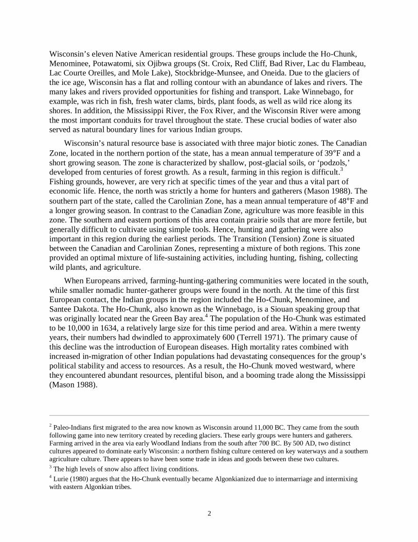
French explorers, fur traders, and missionaries provided the earliest mention of Wisconsin’sIndians by Europeans. Jean Nicolet was the first known European to have come to Wisconsinaround 1634. He is thought to have met with the Ho-Chunk somewhere around 1640 (Mason1988). The European presence in North America, however, had exerted a substantial influenceeven before this time. The fur trade, for example, introduced both European goods and Indiangroups from outside the region. At the time of contact, most of the state’s Indian groups wererelated to the Oneota culture, which was characterized by intricate adaptations to a varied naturalresource base (ibid. 1988).
Wisconsin’s natural resource base largely directed early indigenous settlement patterns.2 Asa result, the land and its natural resource base provide a telling starting point to the history of
1 This research was supported by a grant from the Land Tenure Center at the University of Wisconsin-Madison. Wethank Gene Summers for his assistance in launching this project and Paul Voss for his helpful suggestions aboutsmall area population projections.
2
Wisconsin’s eleven Native American residential groups. These groups include the Ho-Chunk,Menominee, Potawatomi, six Ojibwa groups (St. Croix, Red Cliff, Bad River, Lac du Flambeau,Lac Courte Oreilles, and Mole Lake), Stockbridge-Munsee, and Oneida. Due to the glaciers ofthe ice age, Wisconsin has a flat and rolling contour with an abundance of lakes and rivers. Themany lakes and rivers provided opportunities for fishing and transport. Lake Winnebago, forexample, was rich in fish, fresh water clams, birds, plant foods, as well as wild rice along itsshores. In addition, the Mississippi River, the Fox River, and the Wisconsin River were amongthe most important conduits for travel throughout the state. These crucial bodies of water alsoserved as natural boundary lines for various Indian groups.
Wisconsin’s natural resource base is associated with three major biotic zones. The CanadianZone, located in the northern portion of the state, has a mean annual temperature of 39°F and ashort growing season. The zone is characterized by shallow, post-glacial soils, or ‘podzols,’developed from centuries of forest growth. As a result, farming in this region is difficult.3
Fishing grounds, however, are very rich at specific times of the year and thus a vital part ofeconomic life. Hence, the north was strictly a home for hunters and gatherers (Mason 1988). Thesouthern part of the state, called the Carolinian Zone, has a mean annual temperature of 48°F anda longer growing season. In contrast to the Canadian Zone, agriculture was more feasible in thiszone. The southern and eastern portions of this area contain prairie soils that are more fertile, butgenerally difficult to cultivate using simple tools. Hence, hunting and gathering were alsoimportant in this region during the earliest periods. The Transition (Tension) Zone is situatedbetween the Canadian and Carolinian Zones, representing a mixture of both regions. This zoneprovided an optimal mixture of life-sustaining activities, including hunting, fishing, collectingwild plants, and agriculture.
When Europeans arrived, farming-hunting-gathering communities were located in the south,while smaller nomadic hunter-gatherer groups were found in the north. At the time of this firstEuropean contact, the Indian groups in the region included the Ho-Chunk, Menominee, andSantee Dakota. The Ho-Chunk, also known as the Winnebago, is a Siouan speaking group thatwas originally located near the Green Bay area.4 The population of the Ho-Chunk was estimatedto be 10,000 in 1634, a relatively large size for this time period and area. Within a mere twentyyears, their numbers had dwindled to approximately 600 (Terrell 1971). The primary cause ofthis decline was the introduction of European diseases. High mortality rates combined withincreased in-migration of other Indian populations had devastating consequences for the group’spolitical stability and access to resources. As a result, the Ho-Chunk moved westward, wherethey encountered abundant resources, plentiful bison, and a booming trade along the Mississippi(Mason 1988).
2 Paleo-Indians first migrated to the area now known as Wisconsin around 11,000 BC. They came from the southfollowing game into new territory created by receding glaciers. These early groups were hunters and gatherers.Farming arrived in the area via early Woodland Indians from the south after 700 BC. By 500 AD, two distinctcultures appeared to dominate early Wisconsin: a northern fishing culture centered on key waterways and a southernagriculture culture. There appears to have been some trade in ideas and goods between these two cultures.3 The high levels of snow also affect living conditions.4 Lurie (1980) argues that the Ho-Chunk eventually became Algonkianized due to intermarriage and intermixingwith eastern Algonkian tribes.
3
The Menominee represent Wisconsin’s earliest residents, having occupied the area for morethan 10,000 years. Their early population size is unknown, but some evidence suggests they wereconsiderably smaller than the Ho-Chunk. By the time the first European explorers arrived inWisconsin in 1634, the Menominee were hunting much of the eastern part of the state. Theylived primarily in an area encompassing Milwaukee, Michigan’s upper peninsula, and west ofBlack River Falls. Although the exact location of their settlements is unknown, their “GrandVillage” is known to have been located at the mouth of the Menominee River at the time ofcontact.
The Santee Dakota, known as the Sioux, were a third Indian group in Wisconsin whenNicolet arrived. The Santee Dakota are believed to come from north of the Great Lakes, movingsouthwest until they encountered attacks by the Ojibwa and other tribes in Sault St. Marie. By1640, they were located on Lake Winnebago, as well as near the Mississippi and St. Croix River(Kubiak 1970). By the late 1600s, they had a little over twenty villages along the Mississippi,while claiming the entire west bank to the Des Moines River as hunting territory.
Apart from these three original Indian groups, many Indian groups had migrated intoWisconsin by the 1640s.5 This migration was due in large part to warfare with the Iroquois in theEast and the politically destabilizing expansion of the fur trade. The Potawatomi and Ojibwawere among these migrant Indian groups. They were related to the Anishinabe, who lived alongthe east coast of Canada near the mouth of the St. Lawrence River.6 The Potawatomi, or theNeshnabek, first arrived in Green Bay around 1648 from the Lower Peninsula of Michigan andthe east shore of Lake Michigan. Here, they defeated the Iroquois’ attacks from the east. Theyultimately spread south and back east into Michigan and Illinois (Mason 1988). Arriving in 1695,the Ojibwa also entered the area via Green Bay. They were at constant war with the SanteeDakota over hunting lands. As their population grew, various groups of the Ojibwa spreadthroughout much of northern Wisconsin (ibid. 1988).
The effect of these in-migrating Indian groups on Wisconsin’s original Indian groups varied.Both the Ho-Chunk and the Menominee moved further west. The Santee Dakota appeared tohave posed the most ardent challenge to the newcomers, engaging in numerous confrontationsand battles (Mason 1988). In the latter half of the 17th century, however, the newcomers hadsettled into new villages. European missions and trading posts were also well-established by theturn of the century. In 1689, Nicolas Perrot took possession of Wisconsin for France, exerting adistinct French influence on the region well in to the 1700s. France’s defeat by the British inQuebec in 1760 marked a change in metropolitan rule. However, it did not alter the devastatingeffects of trade and migration, intra-tribal conflict, and European diseases on the Indian groups inWisconsin.
During this early contact period, the flora and fauna of the region created patterns of trade,travel, and settlement that had a substantial effect on population growth and decline in the area.The fur trade, for example, led to the in-migration of numerous Indian groups from outside the
5 Eleven other Indian tribes arrived in Wisconsin at different times after contact, but eventually migrated out of, orwere removed from the state. They included the Miami, the Sauk and Fox, the Kickapoo, the Illini, the Mascouten,the Huron, and the Tionontati.6 Around the 10th century, the Anishinabe began a western migration that took approximately 500 years. Uponreaching Sault Saint Marie in Michigan, they split into three groups: the Potawotami, the Ojibwa, and the Ottawa(Oxley 1981).
4
region, not to mention various European traders. As a result, some areas of Wisconsinexperienced considerable conflict and competition over natural resources. At the same time,downward pressure on the Indian population was also occurring during this period, primarilythrough the importation of European diseases. The Ho-Chunk provides just one shockingexample of such population decline. Illustrated here is a nascent reciprocal relationship betweenland and population change, situated at a particular historical moment.
WISCONSIN STATEHOOD AND THE RESERVATION PERIOD
The Americans gained possession of the Wisconsin areas as a result of the War of 1812. Thechange marked a critical shift in Wisconsin land tenure patterns. In contrast to British and Frenchtraders, American settlers came to farm rather than trade. Thus, they settled down instead ofmoving on. They also arrived in larger numbers, bringing their families and establishing stablefarming communities. The settlers soon put pressure on the U.S. government to open up moreland for settlement via Indian land acquisition and/or Indian removal (Mason 1988). The age offierce land politics witnessed elsewhere in the U.S. had at last arrived in Wisconsin, signalingnew patterns of land use and migration.
Land acquisition by white setters followed a familiar pattern of territorial demarcation andtreaty signing. The process signaled dwindling land control among Wisconsin’s Indian groups.However, land grabbing was also uneven and concentrated in the Carolinian zone, whereagriculture was more viable. Among the first and most important treaties was the Treaty ofPrairie du Chien of 1825. While the treaty’s official purpose was to settle intra-tribal conflict, italso served to draw rigid boundaries for Wisconsin Indian tribes. Legally established boundariesaided white setters in identifying those tribes whose land they wished to acquire. As a result, theTreaty of Prairie du Chien initiated a process of dwindling Indian territory in southeasternWisconsin. By the time Wisconsin was admitted into the Union in 1848, most Indian land inWisconsin had been ceded by treaty.
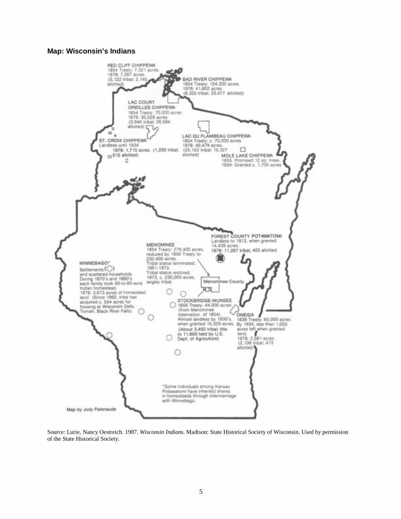
White settlers did not penetrate the north woods in large numbers. The Canadian Zone wasless suitable for agriculture, making white settlement in this region slow and sporadic. Thus, theregion’s Indians came to be concentrated in the north, where they were not under immediatepressure to leave. They remained in the area until signing treaties between 1854 and 1856, whichassigned them to reservations in the north.7 As a result, most of Wisconsin’s Indian reservationsare located in the Canadian and Transition Zones (see map). Their location in this area wouldhave profound implications for economic development strategies in later periods. In this initialperiod, however, the creation of reservations more prominently marked new boundaries ofpolitical influence and residential living. What these patterns meant for Wisconsin’s Indian tribesdepended largely on the individual group. The remainder of this section will briefly outline theshape of this emerging map for individual tribes.
7 The reservation system was largely a response to the realization that Indian removal to the west of Mississippi wasboth costly and dangerous. Such relocation threatened potential alliances among Indian groups and various Plainstribes against whites.
5
Map: Wisconsin’s Indians
Source: Lurie, Nancy Oestreich. 1987. Wisconsin Indians. Madison: State Historical Society of Wisconsin. Used by permissionof the State Historical Society.
6
The Ho-Chunk claimed most of southern Wisconsin as a result of the Treaty of Prairie duChien. Their land was bounded on the southeast by the Rock River, the Mississippi on the west,and the Fox-Wisconsin on the north. The territory includes all of Lake Winnebago and parts ofthe Lower Fox River, as well as rich farmland, lead mines, and the main water routes through theregion. In 1829, pressure from white settlers and miners led to several large land cessions inreturn for land west of the Mississippi. The remaining land was taken from the Ho-Chunk in1837 (Mason 1988). The group was forced to resettle in northeast Iowa, south-central Minnesota,and later, in Nebraska and South Dakota. Many returned to Wisconsin where, lacking reservedlands, they established scattered but enduring communities.8 These Indians resided in Wisconsinas fugitives, planting and hunting on the edges of rural America. In 1874, the Ho-Chunk tribewas granted 40-acre homesteads in Wisconsin, which totaled less than 4,000 acres in 1969.
At the beginning of the 19th century, Menominee land claims stretched to Green Bay andLake Michigan in the east, the Black River in the west, and the Milwaukee River in the south.Treaties signed between 1831 and 1836 allowed the federal government to purchase Menomineeland at will, forcing the tribe to cede all their northern land. Although many Menomineeremained in the area, pressure from white setters led to the Treaty of 1848, which required theMenominee to sell their remaining land in Wisconsin and resettle in Minnesota (Mason 1988,Ourada 1990).9 A delegation of Menominee eventually traveled to Washington D.C. to contestthe unfair treaty. Their efforts culminated in the Treaty of 1854, which granted the tribe areservation along the Wolf River. Their lands were reduced to 232,400 acres by treaty in 1856.
In the Treaty of Chicago of 1833, the Potawatomi lost all their land in Wisconsin andaccepted land in Kansas. Many Potawatomi, however, refused to move to Kansas, insteadmoving north into Canada, Michigan, or back into Wisconsin. Potawatomi fugitives inWisconsin were often caught and sent back to Kansas, but many were able to remain in thenorthern parts of Wisconsin. In 1913, small reservations at Stone Lake and Wabeno were createdfor the Potawatomi (Lurie 1969, Mason 1988). Today, the reservations feature checkeredsettlements covering an area of approximately 14,500 acres.
When copper was discovered on the south shore of Lake Superior, government pressurebegan to push the Objibwa west of the Mississippi. The Objibwa, also known as the Chippewa,sold their mineral rights in 1826 and eventually lost most of their land by treaty between 1833and 1854. A series of agreements and treaties beginning in 1854 led to the creation of theexisting Ojibwa reservations in Wisconsin (Lurie 1980).
• The St. Croix Chippewa reservation in northwest Wisconsin includes eleven separate Indiancommunities. The reservation features numerous lakes and a portion of Wisconsin’s northwoods. The St. Croix Chippewa reservation held 1,750 acres in 1934.
• The Red Cliff Band of Lake Superior Chippewa is situated on the Northern shoreline of theBayfield Peninsula. Its reservation land has hovered consistently above 7,000 acres since1854.
8 In 1881, the federal government created two separate tribes of the Ho-Chunk: the Wisconsin Ho-Chunk and theNebraska Winnebago (Lurie 1969, Mason 1988).9 Chief Oshkosh of the Menominee reluctantly signed the Treaty of 1848 after much pressure by then Commissionerof Indian Affairs, William Medill.
7
• The Bad River Chippewa Reservation is situated in the northwest portion of the state,primarily along Wisconsin’s northern coast of Lake Superior. The reservation features16,000 acres of wetlands, supporting wild rice harvesting and a fish hatchery. The reservationnow encompasses over 4,000 acres.
• The Lac de Flambeau Band of Lake Superior Chippewa was formally granted a 70,000 acrereservation in north-central Wisconsin. The reservation demarcates an area occupied by theLake Superior Chippewa Indians since 1745 when they settled in the region to takeadvantage of the abundant wildlife of the ‘Lake of Torches,’ or Lac de Flambeau. Today, thereservation consists of approximately 40,500 acres.
• The reservation of the Lac Courte Oreilles Band of Lake Superior Chippewa is located in thewoodland region of northwest Wisconsin. Since 1854, this reservation has dwindled from70,000 to 30,500 acres.
• The Mole Lake (Sokaogon) Band of Lake Superior Chippewa received 1700 acres ofreservation land in 1934 after much struggle. The band is also known as the Lost Tribe sincelegal title to a small reservation established in the Treaty of 1854 was lost in a shipwreck onLake Superior.
By 1821, the Menominee were experiencing territorial conflict with new in-migrating Indiangroups, the Stockbridge-Munsee and Oneida in particular. The Stockbridge-Munsee, like theMenominee, Chippewa, and Potawatomi, are of Algonkian linguistic stock. Mahican in origin,their reservation in Stockbridge, Massachusetts was among the earliest in U.S. history. Due toincreasing pressure from white settlement, both the Stockbridge and Oneida moved westward insearch of new territory. In Indiana, they were joined by the Munsee and Brotherton from NewJersey. Together, the four groups became the Stockbridge-Munsee. The Menominee eventuallyceded two of their twelve townships in 1856, which provided the foundation for the Stockbridge-Munsee reservation. The Stockbridge-Munsee reservation consisted of 44,000 acres in 1856.Another group of Oneida moved separately from New York into Wisconsin. A treaty signed in1838 granted the Oneida 65,000 acres near Green Bay. In 1978, the reservation had dwindled toa little over 2000 acres (Lurie 1980).
Most other Indian groups in Wisconsin at this time were forced to leave. The Ottawa, whowere located around the mouth of the Milwaukee River in the early 19th century, ceded all theirlands in Wisconsin by 1833. They resettled on a reservation on the Missouri River in Kansas.The Prairie du Chien Treaty of 1825, which attempted to resolve conflict between the SanteeDakota and the Sauk and Fox, gave all disputed lands east of the Mississippi to the Santee,forcing the Sauk and Fox to move west of the Mississippi. Black Hawk and his group attemptedto regain the unlawfully lost lands, resulting in the Black Hawk War in 1832. Their defeat led totheir loss of land in Iowa, forcing most Sauk and Fox to move to Kansas and later Oklahoma.The Santee Dakota gave up most of their lands in Wisconsin in 1837. By 1851, they lost theirremaining lands and moved to a narrow strip of land along the Upper Minnesota River (Mason1988).
Thus, during the 1800s, Wisconsin’s Indians experienced considerable population changedue to white settlement in the region. In most cases, these changes stemmed from substantialland loss. The reservation system relegated various Indian groups to the northern part of thestate, where economic activities and population growth were limited. The best agricultural andmineral producing land in the Carolinian Zone was granted to white settlers by government
8
policy and white settler pressure. The migration of white settlers into the state, and the growingimportance of agriculture in the southeastern portion of the state, had enormous implications forIndians’ land use and population change.
FEDERAL INDIAN POLICY AND WISCONSIN INDIAN RESERVATIONS
By the middle of the 19th century, the Indians of Wisconsin were removed or were forced torelocate to very small reservations. The treaty period ended roughly around 1871, at which pointfederal policy turned to efforts around integrating and assimilating Indians into white society.Chief among these efforts was the General Allotment Act, or Dawes Act of 1887. The DawesAct divided tribal lands into 160-acre parcels for individual family heads. These allotments wereto be held in trust by the U.S. government for a period of 25 years, after which the land was to beconveyed in fee simple to Indian owners (Otis 1973, Hakansson1997). In light of its intent toassimilate Indians into the role of farmers, the original act did not allow allottees to lease or selltheir land.
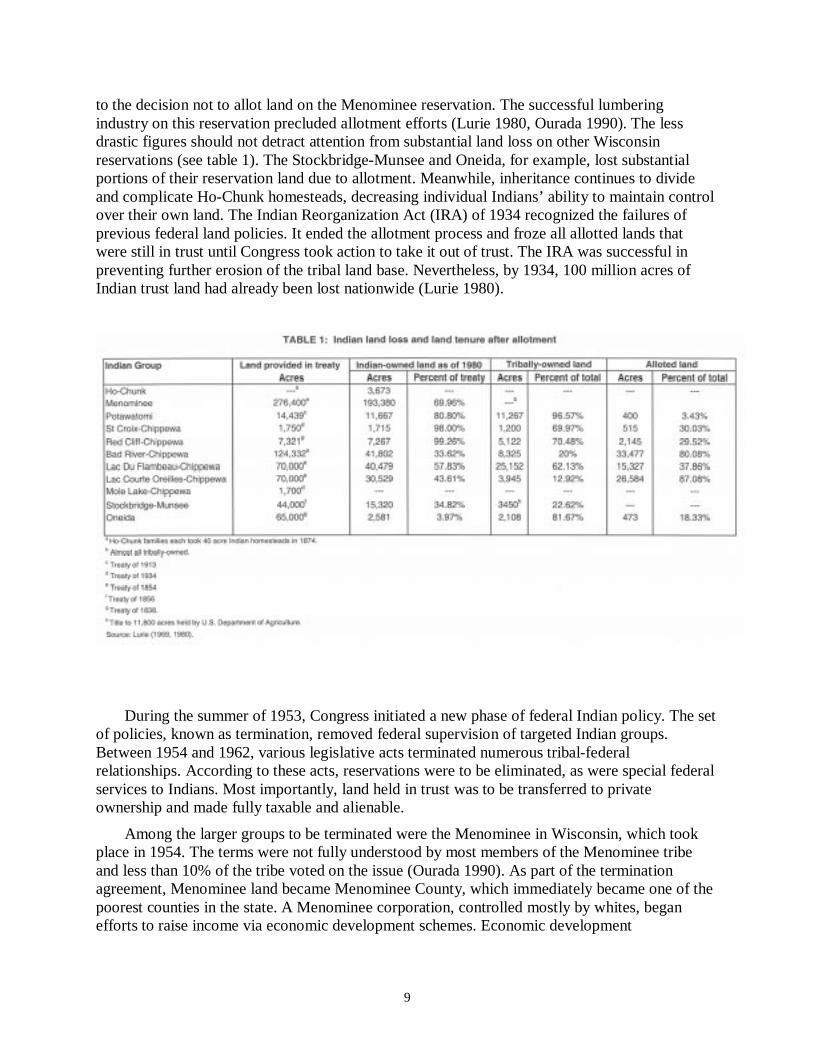
Eventually, non-Indians pressured the government to make possible the leasing of allottedland lying fallow. As a result, congress amended the act through the Land Lease Amendment of1890.10 The amendment allowed Indians with “special disabilities” to lease land up to three yearsfor farming or grazing, and up to ten years for mining purposes. Later, Congress further modifiedthe act to allow any Indians wishing to lease the land to do so. Lease approvals increased from 6in 1894 to 2,500 in 1900. The Burke Act of 1906 aggravated these disastrous results. It allowedthe Secretary of the Interior to issue deeds to “competent” allottees capable of managing theirown affairs. Many more Indians than expected applied for fee patents, some due to unscrupulouspersuasion by non-Indians. Inaccurate processing of applications and failure to check for abusessignaled further land loss (see table 1).
Under Indian probate law, when an individual dies, his/her allotment descends to heirs asundivided “fractional” interests in the individual allotment. In other words, tenancy is held incommon. Since Congress never amended the Indian probate laws, the process of fractionationcontinues today. The major problems with fractionation revolve around the high number ofindividual owners and the complexity of title. It is increasingly difficult to locate landowners forobtaining consent to lease, sell, or acquire property. It is also difficult to secure the agreement ofall owners for decisions around land use. Thus, many individuals and firms are discouraged frompursuing economic development on Indian land (Bureau of Indian Affairs 1994). Any profitsmade from the land accrue to the lessee, frequently a non-resident of the reservation.Administering the land has become quite costly for the Bureau of Indian Affairs as well.Approximately 50-75% of the Bureau’s realty budget goes to administering these fractionalinterests, adversely affecting other programs such as forestry and social services.
While the national figures demonstrate an estimated three-quarters loss in Indian land,Wisconsin’s Indian land base was reduced only by one half. The unique situation was due largely
10 The inability of Indians to make use of the land as farmers was due largely to specific structural factors.Government policy, for example, prevented Indians from using the land as collateral to borrow money forpurchasing seeds, equipment, and stock. Thus, leasing these allotments became an enduring trend, if not a logicalrecourse to such obstacles.
9
to the decision not to allot land on the Menominee reservation. The successful lumberingindustry on this reservation precluded allotment efforts (Lurie 1980, Ourada 1990). The lessdrastic figures should not detract attention from substantial land loss on other Wisconsinreservations (see table 1). The Stockbridge-Munsee and Oneida, for example, lost substantialportions of their reservation land due to allotment. Meanwhile, inheritance continues to divideand complicate Ho-Chunk homesteads, decreasing individual Indians’ ability to maintain controlover their own land. The Indian Reorganization Act (IRA) of 1934 recognized the failures ofprevious federal land policies. It ended the allotment process and froze all allotted lands thatwere still in trust until Congress took action to take it out of trust. The IRA was successful inpreventing further erosion of the tribal land base. Nevertheless, by 1934, 100 million acres ofIndian trust land had already been lost nationwide (Lurie 1980).
During the summer of 1953, Congress initiated a new phase of federal Indian policy. The setof policies, known as termination, removed federal supervision of targeted Indian groups.Between 1954 and 1962, various legislative acts terminated numerous tribal-federalrelationships. According to these acts, reservations were to be eliminated, as were special federalservices to Indians. Most importantly, land held in trust was to be transferred to privateownership and made fully taxable and alienable.
Among the larger groups to be terminated were the Menominee in Wisconsin, which tookplace in 1954. The terms were not fully understood by most members of the Menominee tribeand less than 10% of the tribe voted on the issue (Ourada 1990). As part of the terminationagreement, Menominee land became Menominee County, which immediately became one of thepoorest counties in the state. A Menominee corporation, controlled mostly by whites, beganefforts to raise income via economic development schemes. Economic development
10
encompassed a renewal of the timber industry, as well as the development of a tourist industry.Most importantly, it entailed the selling of Menominee land to non-Indians (Ourada 1990).
Opposition to termination and its aftermath led to the formation of DRUMS (Determinationof Rights and Unity for Menominee Shareholders). Founded by Menominees living inMilwaukee and Chicago, the group protested the sale of Menominee land, discrimination againstIndian children in the schools, and the loss of lumber mill contracts. Their protests preventedfurther land from being sold and eventually led to the Menominee Restoration Act of 1973,which restored the Menominee’s tribal status. Some Menominee tribal members chose to puttheir property into tribal trust once again; others chose to remain private property owners on thereservation (Ourada 1990). Similar confrontations occurred among other Wisconsin Indiangroups. The Lac Court Oreilles Chippewa, for example, occupied the dam site of the NorthernState Power Company in 1971 to protest the flooding of 6,000 acres of reservation land.
Throughout this period, federal policies have had drastic effects on land loss and populationsize on Wisconsin’s Indian reservations. Allotment, fractionation, and termination policies notonly reduced Indian-controlled land, it severely curbed economic options and development onreservations. At the turn of the 20th century, Indian populations began to recover numerically,which put pressure on dwindling natural resources on the reservation. Fragmented land claimspromised little in terms of agriculture, and unemployment soared on the reservation. The searchfor jobs and viable livelihoods led to large-scale urban migration beginning in World War II.
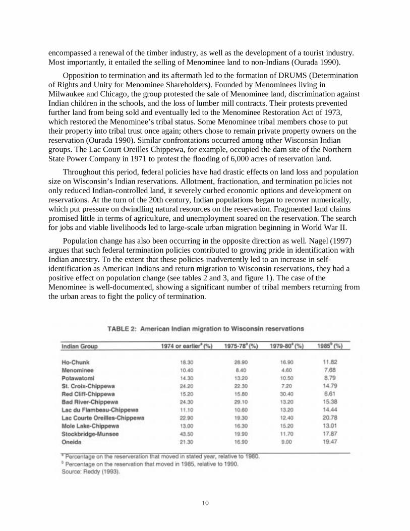
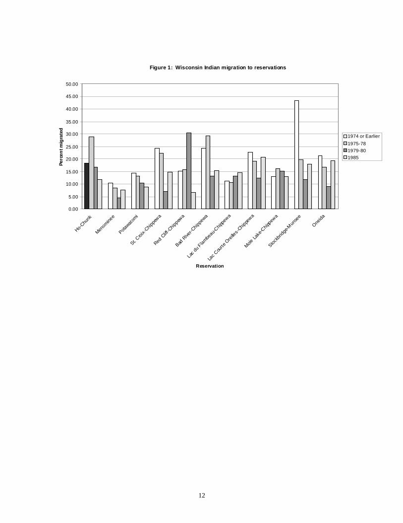
Population change has also been occurring in the opposite direction as well. Nagel (1997)argues that such federal termination policies contributed to growing pride in identification withIndian ancestry. To the extent that these policies inadvertently led to an increase in self-identification as American Indians and return migration to Wisconsin reservations, they had apositive effect on population change (see tables 2 and 3, and figure 1). The case of theMenominee is well-documented, showing a significant number of tribal members returning fromthe urban areas to fight the policy of termination.
11
12
Figure 1: Wisconsin Indian migration to reservations
0.00
5.00
10.00
15.00
20.00
25.00
30.00
35.00
40.00
45.00
50.00
Ho-Chu
nk
Menomine
e
Potawat
omi
St. Croi
x-Chip
pewa
Red C
liff-C
hippew
a
Bad R
iver-C
hippe
wa
Lac d
u Flam
beau-C
hippe
wa
Lac C
ourte
Ore
illes-
Chippewa
Mole La
ke-C
hippew
a
Stockb
ridge
-Mun
see
Oneida
Reservation
Perc
ent m
igra
ted
1974 or Earlier
1975-78
1979-80
1985
13
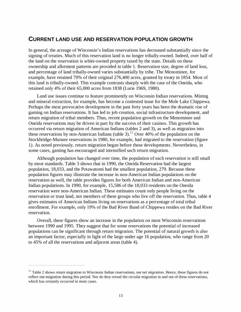
CURRENT LAND USE AND RESERVATION POPULATION GROWTH
In general, the acreage of Wisconsin’s Indian reservations has decreased substantially since thesigning of treaties. Much of this reservation land is no longer tribally-owned. Indeed, over half ofthe land on the reservation is white-owned property taxed by the state. Details on theseownership and allotment patterns are provided in table 1. Reservation size, degree of land loss,and percentage of land tribally-owned varies substantially by tribe. The Menominee, forexample, have retained 70% of their original 276,400 acres, granted by treaty in 1854. Most ofthis land is tribally-owned. This example contrasts sharply with the case of the Oneida, whoretained only 4% of their 65,000 acres from 1838 (Lurie 1969, 1980).
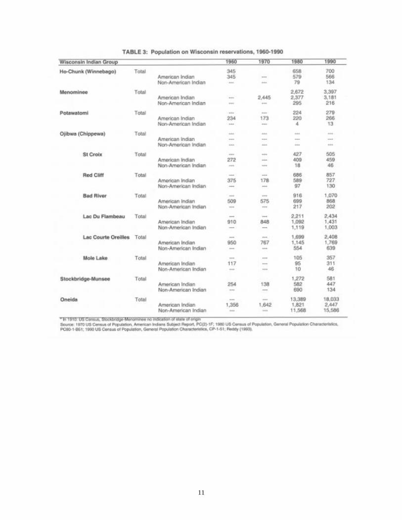
Land use issues continue to feature prominently on Wisconsin Indian reservations. Miningand mineral extraction, for example, has become a contested issue for the Mole Lake Chippewa.Perhaps the most provocative development in the past forty years has been the dramatic rise ofgaming on Indian reservations. It has led to job creation, social infrastructure development, andreturn migration of tribal members. Thus, recent population growth on the Menominee andOneida reservations may be driven in part by the success of their casinos. This growth hasoccurred via return migration of American Indians (tables 2 and 3), as well as migration intothese reservations by non-American Indians (table 3).11 Over 40% of the population on theStockbridge-Munsee reservations in 1980, for example, had migrated to the reservation (figure1). As noted previously, return migration began before these developments. Nevertheless, insome cases, gaming has encouraged and intensified such return migration.
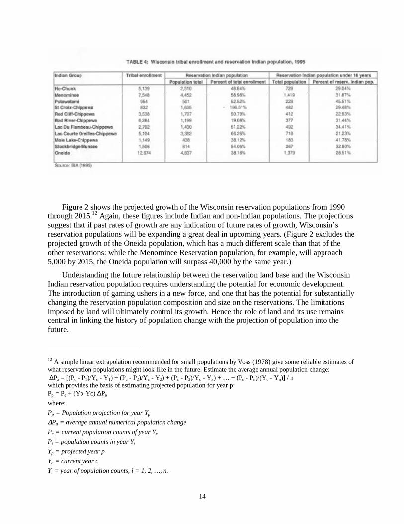
Although population has changed over time, the population of each reservation is still smallby most standards. Table 3 shows that in 1990, the Oneida Reservation had the largestpopulation, 18,033, and the Potawatomi had the smallest population, 279. Because thesepopulation figures may illustrate the increase in non-American Indian populations on thereservation as well, the table provides figures for both American Indian and non-AmericanIndian populations. In 1990, for example, 15,586 of the 18,033 residents on the Oneidareservation were non-American Indian. These estimates count only people living on thereservation or trust land, not members of these groups who live off the reservation. Thus, table 4gives estimates of American Indians living on reservations as a percentage of total tribalenrollment. For example, only 19% of the Bad River Band of Chippewa resides on the Bad Riverreservation.
Overall, these figures show an increase in the population on most Wisconsin reservationsbetween 1990 and 1995. They suggest that for some reservations the potential of increasedpopulations can be significant through return migration. The potential of natural growth is alsoan important factor, especially in light of the large under age 16 population, who range from 20to 45% of all the reservations and adjacent areas (table 4).
11 Table 2 shows return migration to Wisconsin Indian reservations, not net migration. Hence, these figures do notreflect out-migration during this period. Nor do they reveal the circular migration in and out of these reservations,which has certainly occurred in most cases.
14
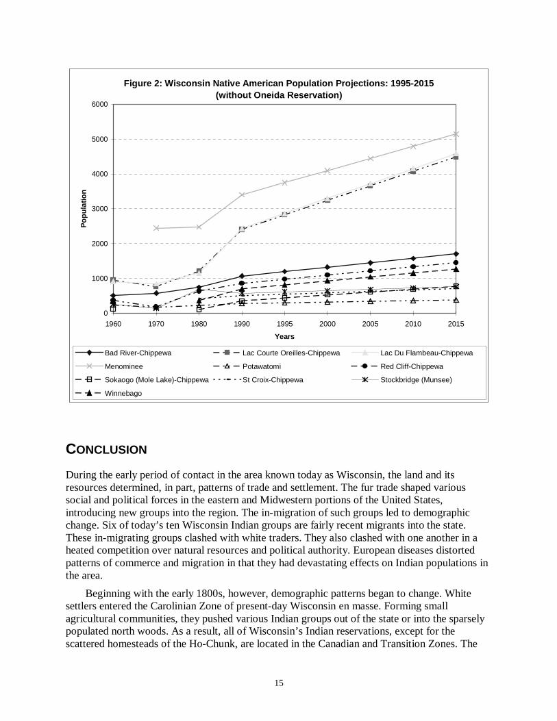
Figure 2 shows the projected growth of the Wisconsin reservation populations from 1990through 2015.12 Again, these figures include Indian and non-Indian populations. The projectionssuggest that if past rates of growth are any indication of future rates of growth, Wisconsin’sreservation populations will be expanding a great deal in upcoming years. (Figure 2 excludes theprojected growth of the Oneida population, which has a much different scale than that of theother reservations: while the Menominee Reservation population, for example, will approach5,000 by 2015, the Oneida population will surpass 40,000 by the same year.)
Understanding the future relationship between the reservation land base and the WisconsinIndian reservation population requires understanding the potential for economic development.The introduction of gaming ushers in a new force, and one that has the potential for substantiallychanging the reservation population composition and size on the reservations. The limitationsimposed by land will ultimately control its growth. Hence the role of land and its use remainscentral in linking the history of population change with the projection of population into thefuture.
12 A simple linear extrapolation recommended for small populations by Voss (1978) give some reliable estimates ofwhat reservation populations might look like in the future. Estimate the average annual population change: ∆Pa = [(Pc - P1)/Yc - Y1) + (Pc - P2)/Yc - Y2) + (Pc - P3)/Yc - Y3) + … + (Pc - Pn)/(Yc - Yn)] / nwhich provides the basis of estimating projected population for year p:Pp = Pc + (Yp-Yc) ∆Pa
where:
Pp = Population projection for year Yp
∆Pa = average annual numerical population change
Pc = current population counts of year Yc
Pi = population counts in year Yi
Yp = projected year p
Yc = current year c
Yi = year of population counts, i = 1, 2, …, n.
15
Figure 2: Wisconsin Native American Population Projections: 1995-2015(without Oneida Reservation)
0
1000
2000
3000
4000
5000
6000
1960 1970 1980 1990 1995 2000 2005 2010 2015
Years
Po
pu
lati
on
Bad River-Chippewa Lac Courte Oreilles-Chippewa Lac Du Flambeau-Chippewa
Menominee Potawatomi Red Cliff-Chippewa
Sokaogo (Mole Lake)-Chippewa St Croix-Chippewa Stockbridge (Munsee)
Winnebago
CONCLUSION
During the early period of contact in the area known today as Wisconsin, the land and itsresources determined, in part, patterns of trade and settlement. The fur trade shaped varioussocial and political forces in the eastern and Midwestern portions of the United States,introducing new groups into the region. The in-migration of such groups led to demographicchange. Six of today’s ten Wisconsin Indian groups are fairly recent migrants into the state.These in-migrating groups clashed with white traders. They also clashed with one another in aheated competition over natural resources and political authority. European diseases distortedpatterns of commerce and migration in that they had devastating effects on Indian populations inthe area.
Beginning with the early 1800s, however, demographic patterns began to change. Whitesettlers entered the Carolinian Zone of present-day Wisconsin en masse. Forming smallagricultural communities, they pushed various Indian groups out of the state or into the sparselypopulated north woods. As a result, all of Wisconsin’s Indian reservations, except for thescattered homesteads of the Ho-Chunk, are located in the Canadian and Transition Zones. The
16
Indian land loss during the 1800s, especially the loss of agricultural and mineral producing land,had important effects on the Indians’ ability to make reservation land economically viable, andhence on population size.
The federal policy of allotment resulted in further land loss and reservation populationdecline. The Oneida people, for example, lost nearly all of their land due to allotment. Today,they are left with only a small fraction of the land they were granted in 1838. Fractionation andtermination only complicated matters. To the degree these policies prevented economicdevelopment on the existing reservation, they curbed economic development and populationgrowth. Out-migration of Indians from the reservations is particularly prominent in this regard.However, these policies also had the opposite effect; many Indians returned from urban areas todefend Indian sovereignty on many reservations as well.
The contemporary picture hinges to a large extent on a limited land base and the prospectsof economic growth through the gaming industry. Population projections for reservation growthare substantial in terms of both Indians and non-Indians. Because population growth willundoubtedly figure prominently in coming years, the dynamics of the land-populationrelationship on Wisconsin’s Indian reservations will continue to have enormous purchase indebates around the state’s reservations. How the relationship will evolve in an unfolding policyenvironment, however, remains unclear.
17
REFERENCES
Bureau of Indian Affairs. 1994. Draft Legislative Proposal to Address the Indian HeirshipProblem through Amendments to the Indian Land Consolidation Act. Washington, D.C.: U.S.Department of Interior, Bureau of Indian Affairs.
______. 1995. Indian Service Population and Labor Force Estimates.
Hakansson, Carl G. 1997. “Allotment at Pine Ridge Reservation: Its Consequences and AlternateRemedies.” North Dakota Law Review 73(2):231-61.
Kubiak, William J. 1970. Great Lakes Indians: A Pictorial Guide. Grand Rapids, Michigan:Baker Book House.
Lurie, Nancy Oestreich. 1969. “Wisconsin Indians: Lives and Lands.” Wisconsin Magazine ofHistory 53:2-20.
______. 1980. Wisconsin Indians. Madison: Wisconsin: State Historical Society of Wisconsin.
Mason, Carol I. 1988. Introduction to Wisconsin Indians: Prehistory to Statehood. Salem,Wisconsin: Sheffield Publishing Company.
Nagel, Joane. 1997. American Indian Ethnic Renewal. Oxford: Oxford University Press.
Otis, Delos Sacket. 1973. The Dawes Act and the Allotment of Indian Lands. Norman,Oklahoma: University of Oklahoma Press.
Ourada, Patricia K. 1990. Indians of North America: The Menominee. New York: Chelsea HousePublishers.
Oxley, Shelley. 1981. The Anishinabe: A Unit on the History of the Bad River Band of LakeSuperior Ojibwa Indians. Madison, Wisconsin: Wisconsin Department of Public Instruction.
Reddy, M. (ed.) 1993. Statistical Record on Native North Americans.
Terrell, John Upton. 1971. American Indian Almanac. New York: The World Publishing Co.
US Census of Population. 1970. American Indians Subject Report. PC(2)-1F.
______. 1980. General Population Characteristics. PC80-1-B51.
______. 1990. General Population Characteristics. CP-1-51.
Voss, Paul R. 1978. Precision in the Wisconsin Small-Area Population Estimation System: AStudy of Variation in Estimates as Length of Time from the Estimation Base Year Increases.Madison, Wisconsin: University of Wisconsin-Madison. Applied Population Laboratory.