Embed Size (px)
Citation preview

LAND AT
HAMMOND GROUND
READ
PHASE 1 PRELIMINARY
RISK ASSESSMENT
Prepared for:
Trustees of Hammond Ground
La Blanche Pierre
Rue De La Blanche Pierre
St Lawrence
Jersey
Channel Islands
JE3 1EX
By:
LK Consult Ltd
Unit 29, Eton Business Park
Eton Hall Road
Radcliffe
Greater Manchester
M26 2ZS
Tel: 0161 763 7200
Email:[email protected]
Date: 22nd April 2016
Ref: LKC 14 1215

Trustees of Hammond Ground
LK Consult Ltd Ref: CL-602-LKC 14 1215-02 [R3] ii
Land at Hammond Ground, Read
April 2016
Site Address Land at Hammond Ground, Read
Report Title Phase 1 Preliminary Risk Assessment
Job Number LKC 14 1215 Document Ref. CL-602-LKC 14 1215-02
Date Issued 22nd April 2016 Report Version R3
Prepared By Catherine Baranek Signature
Reviewed By Colin Crompton Signature
DISCLAIMER This report has been prepared by LKC who have exercised such professional skill, care and diligence as may reasonably be expected of a properly qualified and competent consultant experienced in preparing reports of a similar scope. However, to the extent that the report is based on or relies upon information contained in records, reports or other materials provided to LKC which have not been independently produced or verified, LKC gives no warranty, representation or assurance as to the accuracy or completeness of such information. This report is prepared solely for the benefit of the Trustees of Hammond Ground. It may not be relied upon by, or submitted to a third party for their reliance for the purposes of valuation, mortgage, insurance and regulatory approval, until all invoices have been settled in full. Those using this information in subsequent assessments or evaluations do so at their own risk.
LK Consult Ltd
Document Verification

Trustees of Hammond Ground
LK Consult Ltd Ref: CL-602-LKC 14 1215-02 [R3] iii
Land at Hammond Ground, Read
April 2016
CONTENTS
1 INTRODUCTION 1
2 SITE HISTORY 2
3 ENVIRONMENTAL SETTING 3
4 SITE RECONNAISSANCE 5
5 PRELIMINARY CONCEPTUAL MODEL 6
6 SUMMARY CONCLUSIONS AND RECOMMENDATIONS 10
FIGURES Figure 1: Site Location Plan
Figure 2: Site Boundary and Proposed Development Plan
APPENDICES Appendix A: Historical Maps
Appendix B: Envirocheck Report
Appendix C: Coal Authority Report
Appendix D: Site Reconnaissance (Plan, Photographs and Trial Hole Logs)
Appendix E: Risk Evaluation

Trustees of Hammond Ground
LK Consult Ltd Ref: CL-602-LKC 14 1215-02 [R3] 1
Land at Hammond Ground, Read
April 2016
1 INTRODUCTION
1.1 Background
LK Consult Ltd (LKC) has been commissioned by the Trustees of Hammond Ground to carry out a Phase 1 Preliminary Risk Assessment (PRA) for Land at Hammond Ground, Read. The report was undertaken in support of a future planning application to redevelop part of the site for residential housing. According to guidance set out in CLR111, GPLC1-32 and the National Planning Policy Framework (NPPF)3 a PRA with a site reconnaissance is required as a minimum to ascertain if there is a potential contamination risk. In accordance with current guidance the PRA will include a site reconnaissance, site history, geology, hydrogeology, hydrology, mineral search and a landfill search. Information gathered from the desk study and site reconnaissance will be used to develop a contamination conceptual model for the site, which will support the identification and assessment of any pollutant linkages. Based on the findings of this report, an appropriate site investigation can be derived, if required / once planning approval has been granted.
1.2 Site Settings
A summary of site settings is presented in Table 1-1. Figure 1 indicates the site location. Figure 2 indicates the site boundary and proposed development. It should be noted that the site boundary has altered since the original PRA (ref: LKC 14 1215 02 R0). The report has been adjusted to take the new boundary into account; however, the data in Appendices A-E contains the original boundary.
Location Land at Hammond Ground, north of Whalley Road (A671), Read.
Centred at approximate National Grid Reference 376360E 434560N. Area Approximately 4.089Ha. Topography Approximately 120 metres above ordnance datum (AOD) in the northeastern
area of the site, sloping down to approximately 95m AOD in the southwestern area of the site. Ground is undulated.
Current Land Use
Site Large grassed fields with occasional trees. Surrounding Area North: Agricultural fields with residential properties beyond. East: Residential properties. South: Whalley Road with residential properties and fields beyond. West: Agricultural fields with Clough Syke Brook and woodland beyond.
Proposed Development
Residential development comprising 33 bungalows and 17 houses (all 2/3/4 bedroom dwellings), access roads, open space and pond (associated with surface drainage).
Table 1-1: Summary of site details for Land at Hammond Ground, Read.
1 EA (2004). “Model Procedures for the Management of Land Contamination.” R&D Publication CLR 11 2 EA (2010) “Guiding principles for land Contamination.” GPLC1-3. 3 DCL (2012). “National Planning Policy Framework.” Department of Communities and Local Government. March 2012.

Trustees of Hammond Ground
LK Consult Ltd Ref: CL-602-LKC 14 1215-02 [R3] 2
Land at Hammond Ground, Read
April 2016
2 SITE HISTORY
In compiling the site history, LKC consulted historical mapping provided by the Landmark Information Group Ltd. Copies of relevant historical plans are provided in Appendix A and are summarised Table 2-1. Notable features within 100m of the site boundary have been presented (distances will be approximate). The exception to this will be features within a 250m buffer that could be infilled historically.
Site Features Location Map Dates
Present Comments
Fields Whole Site 1848-2014 - With occasional trees across the site. - Field boundary in the northeastern
corner on 1912-1938 mapping. - Field boundary in the west from 1994
mapping (still present). Surrounding Area
Features Distance/ Location
Map Dates Present
Comments
Old Coal Pit 60m North 1893-1955 - No longer shown on 1960 mapping. Two Mill Ponds / Reservoirs
20m Southeast
1893-1991 - Associated with adjacent Friendship Mill.
- Smaller pond no longer present on 1983 mapping.
- Remaining pond no longer present on 1993 mapping.
Friendship Mill 60m Southeast
1893-2014 - Annotated as Cotton Mill on 1893-1931 mapping (later use unknown).
Grave Yard 100m Northeast
1912-2014 - Part of St John Church (C of E). - Extended to west on 1983 mapping.
Pond 140m Southwest
1931-1955 - No longer present on 1960 mapping.
Electricity Sub Station 60m Southeast
1971-2014 - Located adjacent to Friendship Mill.
Table 2-1: Summary of historical features for Land at Hammond Ground, Read.

Trustees of Hammond Ground
LK Consult Ltd Ref: CL-602-LKC 14 1215-02 [R3] 3
Land at Hammond Ground, Read
April 2016
3 ENVIRONMENTAL SETTING
In compiling this Section, LKC consulted environmental information provided by the Envirocheck Report (Appendix B), British Geological Survey (BGS), the Coal Authority (Appendix D) and the Environment Agency. A summary is presented in Table 3-1.
Categories (data sources) Details
Geology
Artificial1 - None recorded on site.
Superficial1 - Till.
Bedrock1,2
- Series of rock types outcropping on site. - Strata orientated southwest-northeast and dipping
approximately 40-45o to the southeast. - From northwest to southeast:
- Coal seam (northern boundary), - Pennine Lower Coal Measures (mudstone, siltstone,
sandstone), - Milnrow Sandstone, - Coal Seam, - Pennine Lower Coal Measures (mudstone, siltstone,
sandstone).
BGS logs3 - None within 500m.
Hydro-geology
Aquifer Designation
Superficial1 - Unproductive.
Bedrock1 - Secondary A.
Groundwater Abstractions1 - None within 500m. Nearest 966m northeast for general agricultural use at New Hall Farm, Read.
Hydrology
Nearest Surface Water1 - 16m southwest – unnamed stream (issues). - Several unnamed streams (issues) within 250m. - Clough Syke Brook 215m west, flowing north.
Water Quality Data1 - No water quality data within influencing distance.
Flooding1 - No risk from rivers or sea.
Surface Water Abstractions1 - 2 within 500m. Nearest 349m east for industrial cooling and manufacturing at Spence Farm Lodge.
Discharge Consent1 - None within 500m. Nearest 640m southwest for sewage discharges.
Pollution Incidents1 - 2 within 250m. Nearest 146m east, Category 3 Minor Incident, no pollutant found, dated 1992.
Minerals / Mining
Coal Mining Development High Risk Area4
- ‘Probable Shallow Coal Mine Workings’ shown in the north of the site.
- ‘Coal Outcrops’ shown in the north and south of the site.
Coal Report5
- Likely zone of influence from workings in 1 seam of coal at 170-190m depth, last worked 1948.
- Coal Authority believed there is coal at or close to the surface. This coal may have been worked at some time in the past.
- No mine entries within 20m of the site boundary.
Surface Extractions1 - None recorded within 250m. Nearest is 340m NW: Read Cottages - Upper Haslingden Flags (sandstone).
Cheshire Brine Compensation District5 - Not within site area.
Table 3-1: Summary of environmental setting for Land at Hammond Ground, Read. Data Sources: 1 - Envirocheck Report (Appendix A and B); 2 - BGS Sheet 68 1:50,000; 3 - BGS GeoIndex http://mapapps2.bgs.ac.uk/geoindex/home.html; 4 - The Coal Authority Web Mapping Services (WMS) and Interactive Map Viewer http://coal.decc.gov.uk/en/coal/cms/publications/data/map/map.aspx; 5 – Coal Authority Report (Appendix C).

Trustees of Hammond Ground
LK Consult Ltd Ref: CL-602-LKC 14 1215-02 [R3] 4
Land at Hammond Ground, Read
April 2016
Categories (data sources) Details
Ground Stability1 (on-site)
Collapsible Ground - Very Low hazard.
Compressible Ground - No hazard.
Landslide - Very Low hazard.
Running Sand - Very Low hazard.
Shrinking / Swelling Clay - Very Low hazard.
Ground Dissolution - No hazard.
Landfill sites
Known/Registered1 - None recorded within 250m.
Potential1
3 within 250m: - Small pond 140m southwest, no longer present from
1960 mapping. - Mill ponds / reservoirs 20m southeast, no longer
present from 1993 mapping. - Old coal pit 60m north, no longer present from 1960
mapping.
Radon1 - Probability of <1% of homes above Action Level. No further action required.
Designated Sites1 - Adopted Green Belt and Unadopted Green Belt on site.
Contemporary Trade Directory1 - 2 within 100m (both inactive): home furnishing
manufacturers 48m southeast and garage services 52m southeast.
Fuel Station Entries1 - 1 within 100m: 52m east, Friendship Garage (obsolete). Table 3-1 (cont.): Summary of environmental setting for Land at Hammond Ground, Read. Data Sources: 1 - Envirocheck Report (Appendix A and B); 2 - BGS Sheet 68 1:50,000; 3 - BGS GeoIndex http://mapapps2.bgs.ac.uk/geoindex/home.html; 4 - The Coal Authority Web Mapping Services (WMS) and Interactive Map Viewer http://coal.decc.gov.uk/en/coal/cms/publications/data/map/map.aspx; 5 – Coal Authority Report (Appendix C).

Trustees of Hammond Ground
LK Consult Ltd Ref: CL-602-LKC 14 1215-02 [R3] 5
Land at Hammond Ground, Read
April 2016
4 SITE RECONNAISSANCE
A site reconnaissance was carried out on 31st July 2015. Hand dug trial holes were undertaken in accessible areas to confirm the shallow ground conditions. An annotated plan with photographs, trial holes and pertinent features is provided in Appendix D. Relevant features identified on site are summarised below:
Grass field across the whole of the site with occasional mature oak trees, used for animal grazing. It was noted that manure spreading had recently taken place.
Site slopes to the south and west and is undulating in nature. Fence was present towards the west of the site with a metal gate. Bare ground was
noted in the gate area and rare brick was noted at the surface. A small amount of fly tipping was noted along the southern perimeter of the site
which contained fabrics, glass bottles and a microwave. Ground conditions identified grass over sandy clayey topsoil with coal fragments
and rootlets to approximately 0.15mgl to 0.2mbgl over natural sandy clay with coal fragments.
The surrounding area comprises fields and residential properties to the north, residential properties to the east, fields, wooded and densely vegetated areas to the west and Whalley Road and residential properties to the south.

Trustees of Hammond Ground
LK Consult Ltd Ref: CL-602-LKC 14 1215-02 [R3] 6
Land at Hammond Ground, Read
April 2016
5 PRELIMINARY CONCEPTUAL MODEL
5.1 Introduction
The aim of the conceptual model is to provide a preliminary assessment of the likelihood of a pollutant linkage for each potential combination of contaminant, pathway and receptor. A conceptual model can be used to make an informed decision on the contamination risks associated with the site and whether further site investigation work is required. The Sections below are therefore divided into potential contaminant, potential pathway and potential receptor as described in CLR114. The final Section provides an assessment of the potential pollutant linkages that may still be present on the site if redevelopment were to occur.
5.2 Potential Contaminants
The site has comprised fields / agricultural land (grazing) since the earliest available mapping. Significant contamination is not expected from this land use. However, there could be some localised areas of fill across the site where land has been levelled / raised. Fill material could include ash and clinker (from boiler / heath waste) and colliery spoil (from nearby mine entries). Contaminants could include elevated heavy metals, polycyclic aromatic hydrocarbons (PAHs) and sulphate5. Possible asbestos containing material (ACM) could also be present in made ground, depending on the source of made ground. It should be noted that significant made ground was not identified during the site reconnaissance. The only industrial use within the surrounding area is a mill 60m to the southeast. Given the distance from the site, this is not anticipated to be a significant contamination source. Potentially infilled ground has been identified within 250m of the site which could be a source of hazardous gas (carbon dioxide and methane). However, the features identified (ponds, reservoir, mine shaft) are relatively small and unlikely to produce significant quantities of hazardous gas. The site is underlain by the Pennine Middle Coal Measures with a number of coal seam sub-cropping on site and a number of nearby mine entries. This strata could generate ground gas (primarily carbon dioxide and methane) particularly where worked seams are present.
5.3 Potential Pathways
The pathways are spilt into the migration of soil, water and gas. Soil This also includes soil-derived dust, vapours from the soil and the uptake of contaminants from the soil into flora / vegetables. Principal potential pathways associated with human health from soil contamination are ingestion, dermal and inhalation. The current UK technical report document6 recognises
4 Defra (2004). “Model Procedures for the Management of Land Contamination.” R&D Publication CLR 11 5 Defra (2002). “Potential Contaminants for the Assessment of Land.” R&D Publication CLR 8. 6 EA (2008). “Updated Technical Background to the CLEA Model.” Science Report – SC050021/SR3.

Trustees of Hammond Ground
LK Consult Ltd Ref: CL-602-LKC 14 1215-02 [R3] 7
Land at Hammond Ground, Read
April 2016
ten such pathways comprising four ingestion, two dermal and four inhalation. These are listed as follows:
Ingestion of soil • Dermal contact with soil-derived indoor dust Ingestion of soil-derived indoor dust • Inhalation of soil-derived outdoor dust Ingestion of contaminated vegetables • Inhalation of soil-derived indoor dust Ingestion of soil attached to vegetables • Inhalation of vapours outside Dermal contact with soil • Inhalation of vapours inside
The proposed end-use follows a standard conceptual model of ‘residential’. For this land use scenario all ten of the pathways will have to be considered. Soils may be within direct contact with receptors (e.g. building foundations, services). Soils can also generate dust which could migrate via windblown dust to adjacent receptors. Water Surface water and groundwater are principal mechanisms for the migration of contaminants. The following pathways are considered possible:
Surface run-off over impermeable surface. Infiltration into the ground, through potentially contaminated material
(contamination possibly going into solution). Migration through potentially permeable strata and preference pathways (drains,
sewers, culverts, faults, mine workings).
The anticipated Till (superficial) across the site is likely to be relatively impermeable and will significantly reduce the migration of potential contaminated waters. The bedrock is likely to variable permeable and could therefore act as a pathway for the migration of potential contaminated waters. A number of preferential pathways have been identified including mine workings and possible drains / services which could be a pathway to contaminants. Gas Gas can migrate via the following potential pathways:
Migration through potentially permeable strata and preference pathways (drains, sewers, culverts, faults, mine workings).
Migration into buildings (e.g. via services) and accumulation of gases in confined spaces (potentially causing explosion if methane is present).
As discussed above, the geology and preferential pathways may act as pathways for gas migration however the clay across the site should act as a barrier for migrating gas.

Trustees of Hammond Ground
LK Consult Ltd Ref: CL-602-LKC 14 1215-02 [R3] 8
Land at Hammond Ground, Read
April 2016
5.4 Potential Receptors
Potential receptors include:
Human Health: future site residents / site users and offsite land users. Controlled Waters: Streams from 16m southwest, Clough Syke Brook 270m west
and Secondary A Aquifer. Buildings and structures. Potable water pipes. Flora within future gardens/landscaping.
5.5 Preliminary Contamination Conceptual Model
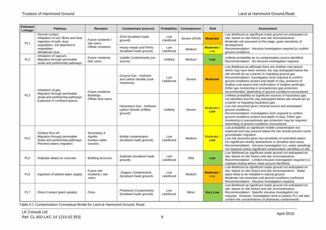
The preliminary contamination conceptual model is illustrated in Table 5-1 below and has identified seven generic potential pollutant linkages. Each linkage is described along with an assessment of the risk based upon guidance on probabilities and consequences outlined in CIRIA C5527. In order to assess the potential risk for each pollutant linkage, an assessment of the magnitude of the potential consequence (severity) of the risk occurring and the magnitude of the probability (likelihood) of the risk occurring has been considered and classified. This is based on the guidance provided in CIRIA C552 and further details including a risk matrix is provided in Appendix E. Where the risk falls into the moderate/low risk, LKC will undertake an assessment to establish what category the pollutant linkage will fall into (i.e. moderate or low risk will be chosen). Where LKC identifies a moderate or higher risk intrusive work or precautionary remedial measures will be recommended. Where LKC identified a low to very low risk either limited intrusive investigation work, a watching brief (during construction work) or no investigation work will be recommended. This will be dependent on the nature of the site and the proposed development. It should be noted that there may be risk from short term exposure from contaminated soil to site workers. The Preliminary Contamination Conceptual Model deals with long term exposure to key receptors. Acute risks can be easily mitigated by good environmental management of the site during site works. Standard health and safety precautions (as per HSE guidance 8 ) should be adopted by all workers involved with site enabling and construction works. Therefore, this receptor is not considered in the contamination conceptual model.
7 CIRIA (2001). “Contaminated land risk assessment: A guide to good practice”. C552. 8 HSE (1991). “Protection of workers and the general public during development of contaminated land” London HMSO.
Trustees of Hammond Ground
LK Consult Ltd Ref: CL-602-LKC 14 1215-02 [R3] 9
April 2016
Land at Hammond Ground,Read
Pollutant Linkage
Pathway Receptor Contaminant (source) Probability Consequence Risk Assessment
PL1
Dermal contact. Inhalation of soil, fibres and dust. Ingestion of soils, dust, vegetables, soil attached to vegetables.
Windblown dust.
Future residents / site users.
Offsite receptors.
ACM (localised made ground).
Low Likelihood
Severe (ACM) Moderate Low likelihood as significant made ground not anticipated on site, based on site history and site reconnaissance.
Moderate risk assumed at this stage, given sensitivity of development.
Recommendation: Intrusive investigation required to confirm ground conditions.
Heavy metals and PAHs (localised made ground).
Low Likelihood
Medium Moderate /
Low
PL2 Inhalation of vapours. Migration through permeable strata and preferential pathways.
Future residents. Site users.
Volatile Contaminants (no source).
Unlikely Medium Low Unlikely probability as no contamination source identified. Recommendation: No intrusive investigation required.
PL3
Inhalation of gas. Migration through permeable strata and preferential pathways.
Explosion in confined spaces.
Future residents. Buildings. Offsite land users.
Ground Gas - methane and carbon dioxide (coal measures).
Low Likelihood
Severe Moderate
Low likelihood as although there are shallow coal seams which may have been worked, the clay anticipated below the site should act as a barrier to migrating ground gas.
Recommendation: Investigation work required to confirm ground conditions (extent and depth of clay, presence of shallow coal seams and confirmation of shallow workings). Either gas monitoring or precautionary gas protection recommended, depending of ground conditions encountered.
Hazardous Gas - methane, carbon dioxide (infilled ground).
Unlikely Severe Moderate /
Low
Unlikely probability as significant sources of hazardous gas not identified and the clay anticipated below site should act as a barrier to migrating hazardous gas.
Low risk assumed given minimal source and anticipated ground conditions.
Recommendation: Investigation work required to confirm ground conditions (extent and depth of clay). Either gas monitoring or precautionary gas protection may be required, depending of ground conditions encountered.
PL4
Surface Run-off. Migration through permeable strata and preferential pathways
Perched waters migration.
Secondary A Aquifer.
Surface water courses.
Mobile contaminants (localised made ground).
Low Likelihood
Medium Moderate /
Low
Low probability as significant mobile contamination not expected and clay present below the site should prevent some groundwater migration.
Low risk assumed given low sensitivity of controlled waters (no significant nearby abstractions or sensitive land uses).
Recommendation: Intrusive investigation (i.e. water sampling) not required unless significant contamination identified on site.
PL5 Sulphate attack on concrete. Building structure. Sulphate (localised made ground).
Low Likelihood
Mild Low
Low likelihood as significant made ground not anticipated on site, based on site history and site reconnaissance.
Recommendation: Limited intrusive investigation required (i.e. sulphate testing where made ground identified).
PL6 Ingestion of tainted water supply. Future site residents / site users.
-Organic Contaminants (localised made ground).
Low Likelihood
Medium Moderate /
Low
Low likelihood as significant made ground not anticipated on site, based on site history and site reconnaissance. Water pipes likely to be installed in natural ground.
Moderate risk assumed until ground conditions confirmed. Recommendation: Intrusive investigation required.
PL7 Direct Contact (plant uptake). Flora. Phytotoxic Contaminants (localised made ground).
Low Likelihood
Minor Very Low
Low likelihood as significant made ground not anticipated on site, based on site history and site reconnaissance.
Recommendation: Specific intrusive investigation not required. However, investigation work to assess PL1 will also confirm the concentrations of phytotoxic contaminants.
Table 5-1 Contamination Conceptual Model for Land at Hammond Ground, Read.

Trustees of Hammond Ground
LK Consult Ltd Ref: CL-602-LKC 14 1215-02 [R3] 10
Land at Hammond Ground, Read
April 2016
6 SUMMARY CONCLUSIONS AND RECOMMENDATIONS
6.1 Summary Conclusions
The site historically comprised fields / agricultural land. The site currently comprises undulated fields used for grazing. The site slopes down to the southwest. The site proposals are for the construction of a residential development. Potential contamination sources affecting the site were identified as heavy metals, PAHs, sulphate, asbestos and hazardous / ground gas (carbon dioxide and methane). These contaminants may pose a risk to site users (via ingestion/dermal contact/inhalation pathways and explosion), controlled waters (via migration through permeable strata / preferential pathways), buildings and structures (direct contact and explosion), water pipes (direct contact) and flora (root uptake). A contamination conceptual model has been produced by LKC. This has identified the following risks summarised in Table 6-1. Where a moderate / low risk was identified, the assumed risk at this stage has been shown.
Pollutant Linkage Risk Further Action Required
1 Contaminants posing a risk to site users via dermal contact, ingestion and inhalation (of
soil, dust, fibres and vegetables). Moderate Investigation work required.
2 Volatile contaminants posing a risk to site
users via the inhalation of vapours. Low Investigation work not required.
3
Hazardous / ground gas posing a risk to buildings and site users via the migration of
gas into building causing explosion and asphyxiation.
Moderate (Ground) Investigation work required to confirm ground
conditions. Either gas monitoring or precautionary gas protection measures may be required. Low
(Hazardous)
4 Mobile contamination posing a risk to
controlled waters via the migration through permeable strata.
Low Investigation work (i.e. water sampling) not
required unless significant contamination identified on site.
5 Sulphate posing a risk to building via direct
contact (sulphate attack). Low
Limited intrusive investigation required (i.e. sulphate testing where made ground identified).
6 Organic contaminants posing a risk to water
pipes. Moderate Investigation work required.
7 Phytotoxic metals posing a risk to flora via
root uptake. Very Low
Specific intrusive investigation not required. However, investigation work to assess PL1 will also confirm the concentrations of phytotoxic
contaminants.
Table 6-1: Risk table for Land at Hammond Ground, Read.
Coal Mining Development High Risk Areas are present in the north and south of the site, associated with the ‘probable shallow coal mining’ and ‘coal outcrops’. A Desk-based Coal Mining Risk Assessment has being produced by LKC under separate cover (ref: LKC 14 1215-03).

Trustees of Hammond Ground
LK Consult Ltd Ref: CL-602-LKC 14 1215-02 [R3] 11
Land at Hammond Ground, Read
April 2016
6.2 Recommendations
In accordance with NPPF, LKC consider that sufficient information on the potential contaminative status of the site is available in this Preliminary Risk Assessment report to allow the validation of any future planning application by the Local Planning Authority and for conditional planning approval to be granted. Such conditional approval will likely include standard prescriptive conditions requiring a site investigation, risk assessment and, if appropriate, a remedial strategy are completed to the satisfaction of the Local Planning Authority prior to the commencement of any development. LKC would recommend that once conditional planning approval is granted, a Phase II intrusive survey should be carried out across the site to investigate the identified potential pollutant linkages further. The scope of this Phase II survey should be prior agreed with the Local Authority and should include the following. In order to address the potential pollutant linkages 1, 5 and 6 a site investigation is recommended. The site investigation should be carried in accordance with relevant guidance documents (including BS101759 and BS593010). The investigation should include trial pits and / or boreholes at a sampling density of 1 sample per 25-50m square centres for an exploratory investigation and 1 sample per 10-25m square centres for a main investigation. Soil samples should be collected from the trial pits / boreholes and tested for contaminants of concern based on the preliminary conceptual model and field observations (PID tests and visual / olfactory evidence). With respect to pollutant linkage 3 (gas risk), it is recommended that the ground conditions are confirmed below the site; including the extent and depth of clay, the presence of shallow coal seams and confirmation of shallow workings. This will allow the requirement for gas monitoring to be confirmed. It may be possible to recommend precautionary gas protection measures as an alternative to gas monitoring if a sufficient depth of clay is present below the site and no workings are identified. If gas monitoring is to be undertaken, boreholes drilled on site should be installed with monitoring wells. Monitoring should be undertaken in accordance with CIRIA C66511. As a minimum gas monitoring would likely be over a three month period with at least six gas monitoring visits under worst case temporal conditions. Precautionary gas protection measures are likely to include a ventilated sub-floor void and installation of a gas membrane. This would need to be and installed as per manufacturer’s instructions and independently validated. LKC do not consider a controlled waters investigation, to assess pollutant linkage 4, is required at this stage. However, if unexpected ground conditions are encountered during investigation work, the controlled waters pollutant linkage may need to be revised and water samples collected. The investigation will identify and characterise any contaminants encountered. Information from this investigation can then be used to provide a more detailed
9 British Standard (2011). “Investigation of Potentially Contaminated Sites – Code of Practice.” BS10175:2011 10 British Standard (1999). “Code of Practice for Site Investigations. “ BS5930:1999 11 CIRIA (2007). “Assessing Risks Posed by Hazardous Ground Gases to Buildings.” CIRIA C665

Trustees of Hammond Ground
LK Consult Ltd Ref: CL-602-LKC 14 1215-02 [R3] 12
Land at Hammond Ground, Read
April 2016
assessment of the identified pollutant linkages and, if necessary, identify appropriate remedial measures to ensure that the site is made suitable for its proposed end use. Boreholes and / or trial pits may also be utilised to provide appropriate geotechnical information on sub-surface conditions. Information from the investigation can provide appropriate foundation solutions. A desk-based Coal Mining Risk Assessment has been carried out which has also recommended a shallow coal mining investigation to confirm the depth of coal seams and the presence of workings.

Trustees of Hammond Ground
LK Consult Ltd Ref: CL-602-LKC 14 1215-02 [R3]
Land at Hammond Ground, Read
FIGURES

0 1,000
metres
Scale: 1:25,000
Figure 1: Location PlanLand at Hammond Ground, Whalley Road, Read
Drawn: November 2015 Scale: 1:25,000 @ A4 (see scale bar)
Site
N
Contains Ordnance Survey dataCrown copyright and database right 2010
©©©©©©©©©©©©©©©©©©©©©©©©©©©©©©©©©©©©©©©©©©©©©©©©©

100.0
Scale: 1:2,500
metres
0
Figure 2: Site Boundary and Proposed Development Plan, Hammond Ground, Whalley Road, Read
Drawn: April 2016 Scale: 1:2,500 @ A4 (see scale bar)
N
Key
Site Boundary
Adapted from plan produced by Green Sky Architecture (Drawing No. 1155-SP Rev. B 30.01.2016)

Trustees of Hammond Ground
LK Consult Ltd Ref: CL-602-LKC 14 1215-02 [R3]
Land at Hammond Ground, Read
APPENDIX A
HISTORICAL MAPS

Order Details
Site DetailsHammond Ground, Read, Burnley, BB12 7RH
Order Number:Customer Ref:National Grid Reference:Slice:Site Area (Ha):Search Buffer (m):
70423210_1_1LKC 14 1215376360, 434560A3.54100
Tel:Fax:Web:
0844 844 99520844 844 9951www.envirocheck.co.uk
Page 1 of 11A Landmark Information Group Service v47.0 24-Jul-2015
Historical Map - Segment A13
Ordnance Survey County Series and Ordnance Survey Plan 1:2,500
Ordnance Survey Plan, Additional SIMs andSupply of Unpublished Survey Information
1:2,500 and 1:1,250
Large-Scale National Grid Data 1:2,500 and 1:1,250
Historical Mapping Legends
Historical Mapping & Photography included:
Lancashire And FurnessLancashire And FurnessLancashire And FurnessOrdnance Survey PlanOrdnance Survey PlanAdditional SIMsAdditional SIMsOrdnance Survey PlanLarge-Scale National Grid DataLarge-Scale National Grid Data
1:2,5001:2,5001:2,5001:2,5001:2,5001:2,5001:2,5001:2,5001:2,5001:2,500
1893191219311960197119781980198319931994
23456789
1011
Mapping Type Scale Date Pg

Order Details
Site DetailsHammond Ground, Read, Burnley, BB12 7RH
Order Number:Customer Ref:National Grid Reference:Slice:Site Area (Ha):Search Buffer (m):
70423210_1_1LKC 14 1215376360, 434560A3.54100
Tel:Fax:Web:
0844 844 99520844 844 9951www.envirocheck.co.uk
Page 2 of 11A Landmark Information Group Service v47.0 24-Jul-2015
Lancashire And FurnessPublished 1893Source map scale - 1:2,500The historical maps shown were reproduced from maps predominantly held at the scale adopted for England, Wales and Scotland in the 1840`s. In 1854 the 1:2,500 scale was adopted for mapping urban areas and by 1896 it covered the whole of what were considered to be the cultivated parts of GreatBritain. The published date given below is often some years later than the surveyed date. Before 1938, all OS maps were based on the Cassini Projection, with independent surveys of a single county or group of counties, giving rise to significant inaccuracies in outlying areas.
Historical Map - Segment A13
Map Name(s) and Date(s)

Order Details
Site DetailsHammond Ground, Read, Burnley, BB12 7RH
Order Number:Customer Ref:National Grid Reference:Slice:Site Area (Ha):Search Buffer (m):
70423210_1_1LKC 14 1215376360, 434560A3.54100
Tel:Fax:Web:
0844 844 99520844 844 9951www.envirocheck.co.uk
Page 3 of 11A Landmark Information Group Service v47.0 24-Jul-2015
Lancashire And FurnessPublished 1912Source map scale - 1:2,500The historical maps shown were reproduced from maps predominantly held at the scale adopted for England, Wales and Scotland in the 1840`s. In 1854 the 1:2,500 scale was adopted for mapping urban areas and by 1896 it covered the whole of what were considered to be the cultivated parts of GreatBritain. The published date given below is often some years later than the surveyed date. Before 1938, all OS maps were based on the Cassini Projection, with independent surveys of a single county or group of counties, giving rise to significant inaccuracies in outlying areas.
Historical Map - Segment A13
Map Name(s) and Date(s)

Order Details
Site DetailsHammond Ground, Read, Burnley, BB12 7RH
Order Number:Customer Ref:National Grid Reference:Slice:Site Area (Ha):Search Buffer (m):
70423210_1_1LKC 14 1215376360, 434560A3.54100
Tel:Fax:Web:
0844 844 99520844 844 9951www.envirocheck.co.uk
Page 4 of 11A Landmark Information Group Service v47.0 24-Jul-2015
Lancashire And FurnessPublished 1931Source map scale - 1:2,500The historical maps shown were reproduced from maps predominantly held at the scale adopted for England, Wales and Scotland in the 1840`s. In 1854 the 1:2,500 scale was adopted for mapping urban areas and by 1896 it covered the whole of what were considered to be the cultivated parts of GreatBritain. The published date given below is often some years later than the surveyed date. Before 1938, all OS maps were based on the Cassini Projection, with independent surveys of a single county or group of counties, giving rise to significant inaccuracies in outlying areas.
Historical Map - Segment A13
Map Name(s) and Date(s)

Order Details
Site DetailsHammond Ground, Read, Burnley, BB12 7RH
Order Number:Customer Ref:National Grid Reference:Slice:Site Area (Ha):Search Buffer (m):
70423210_1_1LKC 14 1215376360, 434560A3.54100
Tel:Fax:Web:
0844 844 99520844 844 9951www.envirocheck.co.uk
Page 5 of 11A Landmark Information Group Service v47.0 24-Jul-2015
Ordnance Survey PlanPublished 1960Source map scale - 1:2,500The historical maps shown were reproduced from maps predominantly held at the scale adopted for England, Wales and Scotland in the 1840`s. In 1854 the 1:2,500 scale was adopted for mapping urban areas and by 1896 it covered the whole of what were considered to be the cultivated parts of GreatBritain. The published date given below is often some years later than the surveyed date. Before 1938, all OS maps were based on the Cassini Projection, with independent surveys of a single county or group of counties, giving rise to significant inaccuracies in outlying areas.
Historical Map - Segment A13
Map Name(s) and Date(s)

Order Details
Site DetailsHammond Ground, Read, Burnley, BB12 7RH
Order Number:Customer Ref:National Grid Reference:Slice:Site Area (Ha):Search Buffer (m):
70423210_1_1LKC 14 1215376360, 434560A3.54100
Tel:Fax:Web:
0844 844 99520844 844 9951www.envirocheck.co.uk
Page 6 of 11A Landmark Information Group Service v47.0 24-Jul-2015
Ordnance Survey PlanPublished 1971Source map scale - 1:2,500The historical maps shown were reproduced from maps predominantly held at the scale adopted for England, Wales and Scotland in the 1840`s. In 1854 the 1:2,500 scale was adopted for mapping urban areas and by 1896 it covered the whole of what were considered to be the cultivated parts of GreatBritain. The published date given below is often some years later than the surveyed date. Before 1938, all OS maps were based on the Cassini Projection, with independent surveys of a single county or group of counties, giving rise to significant inaccuracies in outlying areas.
Historical Map - Segment A13
Map Name(s) and Date(s)

Order Details
Site DetailsHammond Ground, Read, Burnley, BB12 7RH
Order Number:Customer Ref:National Grid Reference:Slice:Site Area (Ha):Search Buffer (m):
70423210_1_1LKC 14 1215376360, 434560A3.54100
Tel:Fax:Web:
0844 844 99520844 844 9951www.envirocheck.co.uk
Page 7 of 11A Landmark Information Group Service v47.0 24-Jul-2015
Additional SIMsPublished 1978Source map scale - 1:2,500The SIM cards (Ordnance Survey's `Survey of Information on Microfilm') are further, minor editions of mapping which were produced and published in between the main editions as an area was updated. They date from 1947 to 1994, and contain detailed information on buildings, roads and land-use. These maps were produced at both 1:2,500 and 1:1,250 scales.
Historical Map - Segment A13
Map Name(s) and Date(s)

Order Details
Site DetailsHammond Ground, Read, Burnley, BB12 7RH
Order Number:Customer Ref:National Grid Reference:Slice:Site Area (Ha):Search Buffer (m):
70423210_1_1LKC 14 1215376360, 434560A3.54100
Tel:Fax:Web:
0844 844 99520844 844 9951www.envirocheck.co.uk
Page 8 of 11A Landmark Information Group Service v47.0 24-Jul-2015
Additional SIMsPublished 1980Source map scale - 1:2,500The SIM cards (Ordnance Survey's `Survey of Information on Microfilm') are further, minor editions of mapping which were produced and published in between the main editions as an area was updated. They date from 1947 to 1994, and contain detailed information on buildings, roads and land-use. These maps were produced at both 1:2,500 and 1:1,250 scales.
Historical Map - Segment A13
Map Name(s) and Date(s)

Order Details
Site DetailsHammond Ground, Read, Burnley, BB12 7RH
Order Number:Customer Ref:National Grid Reference:Slice:Site Area (Ha):Search Buffer (m):
70423210_1_1LKC 14 1215376360, 434560A3.54100
Tel:Fax:Web:
0844 844 99520844 844 9951www.envirocheck.co.uk
Page 9 of 11A Landmark Information Group Service v47.0 24-Jul-2015
Ordnance Survey PlanPublished 1983Source map scale - 1:2,500The historical maps shown were reproduced from maps predominantly held at the scale adopted for England, Wales and Scotland in the 1840`s. In 1854 the 1:2,500 scale was adopted for mapping urban areas and by 1896 it covered the whole of what were considered to be the cultivated parts of GreatBritain. The published date given below is often some years later than the surveyed date. Before 1938, all OS maps were based on the Cassini Projection, with independent surveys of a single county or group of counties, giving rise to significant inaccuracies in outlying areas.
Historical Map - Segment A13
Map Name(s) and Date(s)

Order Details
Site DetailsHammond Ground, Read, Burnley, BB12 7RH
Order Number:Customer Ref:National Grid Reference:Slice:Site Area (Ha):Search Buffer (m):
70423210_1_1LKC 14 1215376360, 434560A3.54100
Tel:Fax:Web:
0844 844 99520844 844 9951www.envirocheck.co.uk
Page 10 of 11A Landmark Information Group Service v47.0 24-Jul-2015
Large-Scale National Grid DataPublished 1993Source map scale - 1:2,500'Large Scale National Grid Data' superseded SIM cards (Ordnance Survey's 'Survey of Information on Microfilm') in 1992, and continued to be produced until 1999. These maps were the fore-runners of digital mapping and so provide detailed information on houses and roads, but tend to show less topographic features such as vegetation. These maps were produced at both 1:2,500 and 1:1,250 scales.
Historical Map - Segment A13
Map Name(s) and Date(s)

Order Details
Site DetailsHammond Ground, Read, Burnley, BB12 7RH
Order Number:Customer Ref:National Grid Reference:Slice:Site Area (Ha):Search Buffer (m):
70423210_1_1LKC 14 1215376360, 434560A3.54100
Tel:Fax:Web:
0844 844 99520844 844 9951www.envirocheck.co.uk
Page 11 of 11A Landmark Information Group Service v47.0 24-Jul-2015
Large-Scale National Grid DataPublished 1994Source map scale - 1:2,500'Large Scale National Grid Data' superseded SIM cards (Ordnance Survey's 'Survey of Information on Microfilm') in 1992, and continued to be produced until 1999. These maps were the fore-runners of digital mapping and so provide detailed information on houses and roads, but tend to show less topographic features such as vegetation. These maps were produced at both 1:2,500 and 1:1,250 scales.
Historical Map - Segment A13
Map Name(s) and Date(s)