Embed Size (px)
Citation preview

Land Cover Classification in the Upstate South Carolina and the Saluda-Reedy Watershed
Report submitted to the Saluda-Reedy Watershed Consortium &
the South Carolina Forestry Commission
August 2006
Jeffery Allen, Stephen Sperry, Arvind Pasula, Vrunda Patki and Kang Shou Lu
Strom Thurmond Institute, Clemson University

Sources of Funding
Funding for this project was provided in part by the V. Kahn Rassmussen Foundation and the Urban and Community Forestry Grant Assistance Program administered through the SC Forestry Commission and funded by the USDA Forest Service.
The US Department of Agriculture (USDA) prohibits discrimination in all its programs and activities on the basis of race, color, national origin, gender, religion, age, disability. Political beliefs, sexual orientation, and marital or family status (not all prohibited bases apply to all programs). Persons with disabilities who require alternative means for communication of program information (Braille, large print, audiotapes, etc.) should contact USDA’s TARGET Center at 202/720-2600 (Voice and TDD). To file a complaint of discrimination, write USDA, Director, Office of Civil Rights, Room 326-A, Whitten Building, 14th and Independence Avenue, SW, Washington, DC 20250-9410 or call 202/270-5964 (voice and TDD). USDA is an equal opportunity provider and employer.
2

Forest Cover Change in Upstate South Carolina With rapid changes in land use/land cover occurring across the U.S., remote sensing technology is an essential tool in monitoring urban development and environmental conditions. Using satellite imagery for land cover change detection is possible because changes in light and energy reflectance values that are monitored by the satellite can be translated to changes in land cover categories.
From a strategic perspective, using satellite multispectral imagery such as Landsat Thematic Mapper, offers timely monitoring methods for extensive land areas. The analysis goal is to characterize those areas of important change (e.g. forest clearing or urban land development) between two or more image dates. Our project used a process called unsupervised classification analysis. In this process the computer groups similar reflectance values into numerous classes and the scientist uses samples of aerial photography and other geographic data to define the final classes that are used (eg. developed land, forest land, farm land). Specifically, the imagery was used to derive three classes of forest (deciduous, evergreen and mixed) and then determine the different amounts of those categories in imagery from 1985 and 2000.
Numerous research groups at universities, federal and state agencies use this type of satellite image analysis methodology to produce land cover maps. In the 1990’s the U.S. Fish and Wildlife Service contracted with numerous states to produce land cover maps as part of a nation-wide habitat study. Recently, the U.S. Geological Survey and the U.S. Environmental Protection Agency teamed with other federal agencies to produce the Multi-Resolution Land Cover (MRLC) data set for the entire U.S. The Clemson researchers followed that same methodology to produce the land cover data set for upstate South Carolina.
Study Methodology The study addressed land use and land cover changes in the Upstate region of South Carolina over a 15-year period. This region consists of the following counties: Abbeville, Anderson, Greenville, Greenwood, Laurens, Newberry, Pickens, Spartanburg. The development pattern was the primary focus of this study. The study addresses three aspects of change detection to monitoring natural resources and urban growth:
1. Classification of Land Cover - 1985, 1990, 1995 and 2000 2. Detecting the change over the 15 year period 3. Quantifying the area statistics by year and by counties
The basic premise in using remote sensing data for change detection is that changes in land cover result in changes in light reflectance values that are monitored. Techniques to perform change detection with satellite imagery have become numerous because of increasing versatility in manipulating digital data and increasing computing power.
3

Remote sensing analysis techniques are available to detect land cover changes from multi-temporal remote sensing data sets. Initiatives to monitor land cover and land use change are increasingly relying on information derived from remotely sensed data because it is cost effective. Such information provides the data link to other techniques designed to understand the human processes behind environmental changes. Remote sensing data analysis is advantageous in that it samples large geographic areas at a fraction of the cost of ground-based surveys. For example, the Forest Inventory Analysis (FIA) also monitors change in forest cover over time. However, that dataset only contains a few sampling points per county and while very useful for multi-state or even statewide analysis, the data becomes filled with error when stratified to the county level. For this study, multispectral satellite images were classified into land cover classes. This image type has a robust capability to identify vegetation and development classes and can be broken down to the county level.
The study used Landsat TM and ETM+ scenes that covered the eight-county study area. Dual dates for the scene were acquired for the change detection. The period selected was the leaf-off period from November to February for 1985, 1990 and 2000. Early leaf-on from April to May was used for 1995 because of the lack of sufficient data in the leaf-off period. This time was preferred because no dense canopy obscured urban development. In addition, the scenes were cloud free in the study area. The scenes were geometrically corrected to less than a pixel root mean square error, registered to Universal Transverse Mercator coordinates, zone 17, North American Datum 1983, and resampled to 30-meter pixels by cubic convolution. The adjacent scenes were then mosaiced together. All six reflective bands from both dates were used for the classification. Land cover mapping was conducted for the study area using both satellite imagery and other geospatial data sets. Briefly, the classification used unsupervised clustering program ISODATA to generate 256 classes. The resulting spectral clusters were grouped into 13 classes using ancillary data sources (e.g., 1992 National Land Cover Data classification and 2001 Impervious Surface Data) as required. The grouping of the unsupervised classification used the ERDAS Imagine Grouping Tool.
Classification Scheme The 13 thematic classes resemble the well-established Anderson land use/cover classification system (Anderson et al. 1976). The thematic classes are:
11. Open Water - All areas of open water with total vegetative cover less than 25 percent.
21. Developed, Open Space (Parks, Golf Courses, Open Space) - Vegetation (primarily grasses) planted in developed settings for recreation, erosion control or aesthetic purposes. Impervious surfaces account for less than 20 percent of total cover. Examples include parks, lawns, golf courses, airport grasses and industrial site grasses.
22. Developed, Low Intensity - Includes areas with a mixture of constructed materials and vegetation. Impervious surfaces account for less than 30 percent of total cover. These areas most commonly include single-family housing units.
4

23. Developed, Medium Intensity - Includes areas with a mixture of constructed materials and vegetation. Impervious surfaces account for 30-50 percent of the total cover. These areas most commonly include single-family housing units.
24. Developed, High Intensity - Includes highly developed areas such as commercial sites and highly dense residential developments. Examples include apartment complexes, row houses and commercial/industrial developments. Impervious surfaces account for 50 to 100 percent of the total cover.
31. Barren or Transitional - Areas characterized by bare rock, gravel, sand, silt, clay or other earthen material. Vegetation is less than 20 percent of total cover. This class includes the early grading associated with new development and the exposed lakeshore line resulting from the drought. It also includes clear cutting of forest land.
41. Deciduous Forest - Areas dominated by trees where greater than 75 percent of the tree species shed foliage simultaneously in response to seasonal change.
42. Evergreen Forest (Coniferous) - Areas dominated by trees where greater than 75 percent of the tree species maintain their leaves all year. Canopy is never without green foliage.
43. Mixed Forest Areas dominated by trees where neither deciduous nor evergreen species are greater than 75 percent of total tree cover.
81. Open Fields/Pasture – Areas of grasses, legumes or grass-legume mixtures planted for livestock grazing or the production of seed or hay crops, typically on a perennial cycle.
82. Cultivated Crops - Areas used for the production of crops, such as corn, soybeans, vegetables, tobacco and cotton, typically on an annual cycle.
91. Woody Wetlands - Areas where forest or shrub vegetation accounts for greater than 25 percent of vegetative cover and the soil or substrate is periodically saturated with or covered with water.
92. Emergent Wetlands - Areas where grass vegetation accounts for greater than 25 percent of vegetative cover and the soil or substrate is periodically saturated with or covered with water.
The classification followed the 2001 National Land Cover Data (NLCD) scheme. It is a modification of the previous 1992 NLCD classes. The new scheme uses percent of impervious surfaces for development classes as opposed to the land uses such as commercial and transportation. Impervious surface is more consistent with the capability of satellite imagery. This new scheme is being used for the National Land Cover Characterization 2001 project. It is a cooperative effort involving several US Federal agencies – USGS, EPA, USFS and NOAA – who will compile land cover data (NLCD 2001) across all 50 states and Puerto Rico and update the 1992 NLCD classification.
5

The final classification was an aggregation of the 13-classification scheme:
1. Open Water – same as class 11 above 2. Development – all developed classes 21, 22, 23 and 24 3. Transitional or Barren – same as class 31 above 4. Forest – all forest classes 41, 42 and 43 5. Pasture and Cultivated – both classes 81 and 82 6. Wetlands – both classes 91 and 92.
Urban Classification and Conflict Steps were taken in processing the data to stratify urban or high intensity classes from rural stratification or cultivated crops. The grouping of the unsupervised classification used the ERDAS Imagine Grouping Tool. The highest priority was given to the development classes. Table 1 shows the conflict among the 13 classes. Developed areas, due to confusion with bare soil, can be classified more accurately if done separately from agricultural or rural areas (Robinson & Nagel, 1990). For this reason, road data were overlaid on the imagery to aid visual identification of urban areas. High intensity development was separated from cultivated land by careful manual delineation around large urban areas approximately over 100 contiguous pixels. The new 2001 impervious surface layer from USGS was used to check for where development would eventually occur in the earlier years, and was also merged into the 2000 scheme.
Table 1. The Most Frequent Conflict Between Mapped Land Cover Classes.
Class Name Primary Conflict Secondary Conflict Open Water Woody Wetlands Coniferous Forest Developed Open Space Open Field/Pasture Cultivated Crops Low Intensity Development Mixed Forest Open Field/Pasture Medium Intensity Development
High Intensity Development Low Intensity Development
High Intensity Development Medium Intensity Development
Cultivated Cropland
Barren High Intensity Development Cultivated Crops Deciduous Forest Mixed Forest Coniferous Forest Coniferous Forest Mixed Forest Woody Wetlands Mixed Forest Coniferous Forest Deciduous Forest Open Field/Pasture Cultivated Cropland Developed Open Space Cultivated Cropland High Intensity Development Barren Woody Wetlands Coniferous Forest Open Water Emergent Wetlands Coniferous Forest Open Water In comparing the grouping of the classes there were some conflicts. These conflicts result in classification errors that are inherent in any air photo or satellite image analysis. Classification errors for these data sets fell within the acceptable ranges set forth by the National Land Cover Data’s (NLCD) Multi-Resolution Land Cover (MRLC) data set. Factors that have contributed to disagreements between mapped land cover include:
6

1) 1990 and 1995 Landsat TM data quality and rectification error, 2) Late fall and early winter time periods – clear-cut, bare earth vs. paved urban
areas(open fields/pasture, cultivated crops and high intensity development) 3) Spatial uncertainty, such as reduced water level from the drought.
7

Appendix A
Land Cover and Tree Cover Classes in the Upstate: 1985 and 2000
8
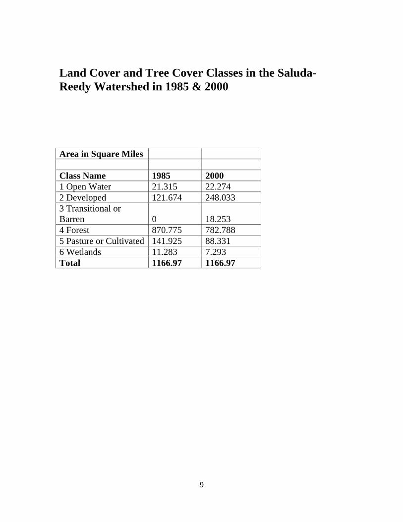
Land Cover and Tree Cover Classes in the Saluda-Reedy Watershed in 1985 & 2000
Area in Square Miles Class Name 1985 2000 1 Open Water 21.315 22.274 2 Developed 121.674 248.033 3 Transitional or Barren 0 18.253 4 Forest 870.775 782.788 5 Pasture or Cultivated 141.925 88.331 6 Wetlands 11.283 7.293 Total 1166.97 1166.97
9

Individual County Breakouts
Zone: Greenville County 1985 2000Class Name Square Miles Square Miles
Deciduous Forest 423.667 134.259Evergreen Forest 142.396 205.048
Mixed Forest 15.174 120.551Zone: Spartanburg County 1985 2000
Class Name Square Miles Square MilesDeciduous Forest 391.695 121.124Evergreen Forest 156.852 213.833
Mixed Forest 21.337 115.87Zone: Pickens County 1985 2000
Class Name Square Miles Square MilesDeciduous Forest 271.875 81.678Evergreen Forest 128.337 182.021
Mixed Forest 5.954 80.05Zone: Anderson County 1985 2000
Class Name Square Miles Square MilesDeciduous Forest 291.071 112.134Evergreen Forest 130.025 199.392
Mixed Forest 14.088 92.991Zone: Laurens County 1985 2000
Class Name Square Miles Square MilesDeciduous Forest 326.844 140.947Evergreen Forest 212.24 250.3
Mixed Forest 10.863 119.026Zone: Newberry County 1985 2000
Class Name Square Miles Square MilesDeciduous Forest 245.871 107.239Evergreen Forest 246.984 275.231
Mixed Forest 9.063 86.813Zone: Abbeville County 1985 2000
Class Name Square Miles Square MilesDeciduous Forest 222.455 100.658Evergreen Forest 160.521 204.267
Mixed Forest 6.025 72.761Zone: Greenwood County 1985 2000
Class Name Square Miles Square MilesDeciduous Forest 186.008 81.51Evergreen Forest 178.215 197.796
Mixed Forest 4.624 58.279
Totals 3802.184 3353.778
10

Appendix B
Land Cover and Forest Cover Maps in the Upstate: 1985 and 2000
11

12

13