Embed Size (px)
Citation preview

URBAN ENTERPRISE URBAN PLANNING LAND ECONOMICS TOURISM PLANNING INDUSTRY SOFTWARE
389 ST GEORGES RD NORTH FITZROY 3068 VIC | PH: (03) 9482 3888 | WWW.URBANENTERPRISE.COM.AU
LAND FOR BUSINESS ASSESSMENT AREAS – EMPLOYMENT
LAND AND ACTIVITY CENTRES TECHNICAL REPORT B
KNOX CITY COUNCIL
DECEMBER 2016

AUTHORS
Paul Shipp, Jojo Chen, Kurt Ainsaar, Brett Hannah
URBAN ENTERPRISE
URBAN PLANNING LAND ECONOMICS TOURISM PLANNING INDUSTRY SOFTWARE
389 ST GEORGES RD, FITZROY NORTH, VIC 3068| PH: (03) 9482 3888
www.urbanenterprise.com.au
This work is copyright. Apart from any uses permitted under Copyright Act 1963, no part
may be reproduced without written permission of Urban Enterprise Pty Ltd.
FILENAME: Technical Report B – Land for Business Assessment Areas – Employment Land
and Activity Centres
VERSION: 3
DISCLAIMER
Neither Urban Enterprise Pty. Ltd. nor any member or employee of Urban Enterprise Pty. Ltd. takes
responsibility in any way whatsoever to any person or organisation (other than that for which this
report has been prepared) in respect of the information set out in this report, including any errors or
omissions therein. In the course of our preparation of this report, projections have been prepared on
the basis of assumptions and methodology which have been described in the report. It is possible that
some of the assumptions underlying the projections may change. Nevertheless, the professional
judgement of the members and employees of Urban Enterprise Pty. Ltd. have been applied in making
these assumptions, such that they constitute an understandable basis for estimates and projections.
Beyond this, to the extent that the assumptions do not materialise, the estimates and projections of
achievable results may vary.

CONTENTS
1. OVERVIEW 2
1.1. INTRODUCTION 2
2. AC-01: ROWVILLE ACTIVITY CENTRE 4
3. AC-02: KNOX CENTRAL ACTIVITY CENTRE 8
4. AC-03: BORONIA ACTIVITY CENTRE 12
5. AC-04: BAYSWATER ACTIVITY CENTRE 16
6. HP-01: WANTIRNA HOSPITALS 20
7. E-01: BAYSWATER (CENTRAL) 24
8. E-02A: BAYSWATER (WEST - MOUNTAIN HWY & STUD RD) 28
9. E-02B: BAYSWATER (WEST - STUD RD) 32
10. E-03: KNOX CENTRAL EMPLOYMENT 35
11. E-04: MOUNTAIN GATE INDUSTRIAL ESTATE 39
12. E-05: KNOXFIELD EMPLOYMENT 43
13. E-06: SCORESBY (NORTH FERNTREE GULLY RD/JELLICO DRIVE) 47
14. E-07: CARIBBEAN PARK & SCORESBY INDUSTRIAL 50
15. E-08: UPPER FERNTREE GULLY 54
16. E-09: BAYSWATER (EAST) 58
17. E-10: ROWVILLE (SOUTH SIDE WELLINGTON RD) 62
18. E-11: ROWVILLE (KELLETTS RD) 66
19. E-12: EDINA RD INDUSTRIAL ESTATE 70
20. E-13: ROWVILLE (CORPORATE AVE, WELLINGTON RD) 74
21. E-14: ENTERPRISE BUSINESS PARK 78
22. NC-01: WELLINGTON VILLAGE SHOPPING CENTRE 82
23. NC-02: SCORESBY VILLAGE SHOPPING CENTRE 85
24. NC-03: WANTIRNA MALL 89
25. NC-04: FERNTREE GULLY (NORTH BURWOOD HWY) 93
26. NC-05: ROWVILLE LAKES 97
27. NC-06: HARCREST BOULEVARD 100
28. NC-07: UPPER FERNTREE GULLY VILLAGE 103
29. NC-08: FERNTREE GULLY VILLAGE 107
30. NC-09: MOUNTAIN GATE CENTRAL 111
31. BG-01: FERNTREE GULLY (BURWOOD HWY CENTRAL) 115
32. BG-02: MOUNTAIN GATE TRIANGLE 119
33. BG-03: KNOXFIELD BUNNINGS 123
34. BG-04: KNOXFIELD (SOUTH FERNTREE GULLY RD) 126
35. BG-05: EASTLINK TRIANGLE 129
36. STRIP SHOPS 132
37. PLANNING PERMITS 139

2 T E C H N I C A L R E P O R T B – L F B A S S E S S M E N T A R E A S : E M P L O Y M E N T L A N D & A C T I V I T Y C E N T R E S K N O X L A N D F O R B U S I N E S S
1. OVERVIEW
1.1. INTRODUCTION
This technical report provides data and mapping for each ‘Land for Business’ assessment area in the City of Knox. The data has been compiled
through a combination of sources, primarily the Council rates database and the State Government Urban Development Program, along with
planning permit data provided by Council.
Information regarding land uses and vacant and underutilised sites was sourced through site visits undertaken by Urban Enterprise in May
2016.
Mapping shows the properties within the Land for Business Assessment Areas, as well as a 100m buffer around the business zones. Any
businesses in this buffer area were identified in order to understand the role of businesses, especially home based business and health
services, locating in proximity to existing activity centres and employment land areas.
The Assessment Areas were selected principally based on the following land zones applying: Industrial 1 Zone (IN1Z), Commercial 1 Zone
(C1Z), Commercial 2 Zone (C2Z), Mixed Use Zone (MUZ) and Priority Development Zone (PDZ).
Data provided is aggregated and summarised in the background report, including:
• Land area and gross floorspace by zone;
• Occupied and vacant gross floorspace by land use and zone;
• Vacant and underutilised lots by area and zone; and
• Maps showing assessment area properties, vacant and underutilised sites, zones and lot size profiles.

U R B A N E N T E R P R I S E 3 J U L - 1 7
FIGURE 1 KNOX LAND FOR BUSINESS ASSESSMENT AREAS: EMPLOYMENT LAND AND ACTIVITY CENTRES
Source: Urban Enterprise 2016

4 T E C H N I C A L R E P O R T B – L F B A S S E S S M E N T A R E A S : E M P L O Y M E N T L A N D & A C T I V I T Y C E N T R E S K N O X L A N D F O R B U S I N E S S
2. AC-01: ROWVILLE ACTIVITY CENTRE ASSESSMENT AREA OVERVIEW
FIGURE 2 AC-01 ASSESSMENT AREA MAP BY ZONE
Source: Knox City Council and compiled by Urban Enterprise.
*Note, Activity Centre boundary is for purposes of Land for Business project, not Activity Centre boundary as defined in Rowville Structure Plan and Knox Planning Scheme.
OTHER ASSESSMENT AREAS RELEVANT TO AC-01
E-13, E-14, SS-01
RELEVANT PLANS/POLICY
Rowville Plan, Knox City Council (2015)
Cl 22.13 Rowville Activity Centre Local Policy
DPO12 – Rowville Commercial Core including Stud Park Shopping Centre
AREA AND FLOORSPACE
TABLE 1 SITE AREA AND GROSS FLOORSPACE BY ZONE
Land Area (sqm) Gross Floorspace (sqm)
C1Z 139,755 31,830
Source: Area measured using QGIS and Gross Floorspace from Knox City Council Rates Database.

U R B A N E N T E R P R I S E 5 J U L - 1 7
LAND USE
TABLE 2 LAND USE BY GROSS FLOORSPACE AND ZONE
Occupied (sqm) Total (sqm)
C1Z
Retail 28,553 28,553
Pubs and Gaming 1,206 1,206
Office 1,132 1,132
Civic 773.7 773.7
Health and Medical 165 165
Total 31,830 31,830
Source: Knox City Council Rates Database.
LOT SIZE DISTRIBUTION
FIGURE 3 LOT SIZE DISTRIBUTION
Source: Area measured using QGIS and compiled by Urban Enterprise.

6 T E C H N I C A L R E P O R T B – L F B A S S E S S M E N T A R E A S : E M P L O Y M E N T L A N D & A C T I V I T Y C E N T R E S K N O X L A N D F O R B U S I N E S S
VACANT AND UNDERUTILISED SITES
FIGURE 4 LOCATION OF VACANT AND UNDERUTILISED SITES
Source: Knox City Council Rates Database and Aerial Imagery.
TABLE 3 VACANT AND UNDERUTILISED SITES BY AREA AND NUMBER OF LOTS
Site Area (sqm) No. of Lots
C1Z
Vacant 4,500 1
Source: Knox City Council Rates Database and Aerial Imagery.

U R B A N E N T E R P R I S E 7 J U L - 1 7
GROUND TRUTH
ROLE/BUSINESS MIX/EXAMPLE OF BUSINESSES
• Main shopping centre in the southern part of the municipality that offers convenience retail, retail services and take away food and
beverage.
• An internal centre that is anchored by Coles and Kmart, and supported by convenience and specialty retail, food and drink premises
and banking services. There is also a Woolworths and some bulky goods retailers (e.g. Petbarn) outside of the centre building, along
Stud Road;
• Located along a major road (Stud Road) means significant traffic and thus is likely to service a significant portion of the residents in the
south of Knox, as well as large numbers from the Rowville Primary School and Rowville Secondary College.
• Examples of businesses include medical centre, real estate, gym, Coles, Kmart, banks, library, and Woolworths.
TYPE AND NUMBER OF BUSINESSES ON THE PERIPHERY
The type of businesses on the peripheral of the Centre include beauty studio, childcare, police station, vet clinic, medical centre and church.
KEY STRATEGIC REDEVELOPMENT SITES (IF ANY)
Vacant site located along Fulham Road (4,500sqm), suitable for a retail mini-major or multiple specialties.
Four Opportunity Sites are identified in the Rowville Structure Plan 2015 within this assessment area. They are: Fulham Road Commercial
Precinct (107 Fulham Rd); Restaurants & Takeaways (1085, 1087 & 1089 Stud Rd); Commercial Building (1091 Stud Rd); and, Stud Park
Shopping Centre (1101 Stud Rd).
ACCESSIBILITY
AC-01 is situated on Stud Road, which is a major private and public transport corridor.
Entry from Stud Road is busy during lunch time and in the afternoon.
Centre is accessible to residents in the northern and north-western parts of Rowville, as well as employment areas to the north and south.

8 T E C H N I C A L R E P O R T B – L F B A S S E S S M E N T A R E A S : E M P L O Y M E N T L A N D & A C T I V I T Y C E N T R E S K N O X L A N D F O R B U S I N E S S
3. AC-02: KNOX CENTRAL ACTIVITY CENTRE ASSESSMENT AREA OVERVIEW
FIGURE 5 AC-02 ASSESSMENT AREA MAP BY ZONE
Source: Knox City Council and compiled by Urban Enterprise.
*Note, Activity Centre boundary is for purposes of Land for Business project, not Activity Centre boundary as defined in Knox Central Urban Design Framework and Knox Planning Scheme.
OTHER ASSESSMENT AREAS RELEVANT TO AC-02
E-03
RELEVANT PLANS/POLICY
Knox Central Urban Design Framework, Knox City Council (2015)
Cl22.04 Knox Central Principal Activity local policy
Clause 52-03 Priority Development Zone - Schedule 1 – Knox Central Urban Design Framework – Rembrants Triangle and Stud Road West.
The draft Knox Central Structure Plan was adopted for public exhibition with Amendment C149 in late 2016. If and when approved this will
replace the Knox Central Urban Design Framework.
AREA AND FLOORSPACE
TABLE 4 SITE AREA AND GROSS FLOORSPACE BY ZONE
Land Area (sqm) Gross Floorspace (sqm)
C1Z 339,165 163,351
MUZ 101,391 14,994
PDZ1 74,483 12,039
PUZ6 45,971 1,913
RGZ1 38,180 16,061
Total 599,190 208,358

U R B A N E N T E R P R I S E 9 J U L - 1 7
Source: Area measured using QGIS and Gross Floorspace from Knox City Council Rates Database.
LAND USE
TABLE 5 LAND USE BY GROSS FLOORSPACE AND ZONE
Occupied (sqm) Vacant (sqm) Total (sqm)
C1Z MUZ PDZ1 PUZ6 RGZ1 C1Z
Retail 139,948 494 140,442
Residential 8,344 12,750 15,162 36,256
Civic 6535.9 1913 8448.9
Office 7,716 350 8,066
Education 7,579 7,579
Highway Sales 450 1,860 2,310
Pubs and Gaming 1,571 705 2,276
Commercial Accommodation 2,244 2,244
Other Commercial 2 535 537
Religious 194 194
Infrastructure and Utility 6 6
Total 163,001 14,994 12,039 1,913 16,061 350 208,358
Source: Knox City Council Rates Database.
LOT SIZE DISTRIBUTION – ISSUE INCLUDE OTHER ZONES
FIGURE 6 LOT SIZE DISTRIBUTION
Source: Area measured using QGIS and compiled by Urban Enterprise.

10 T E C H N I C A L R E P O R T B – L F B A S S E S S M E N T A R E A S : E M P L O Y M E N T L A N D & A C T I V I T Y C E N T R E S K N O X L A N D F O R B U S I N E S S
VACANT AND UNDERUTILISED SITES
FIGURE 7 LOCATION OF VACANT AND UNDERUTILISED SITES
Source: Knox City Council Rates Database and Aerial Imagery.
TABLE 6 VACANT AND UNDERUTILISED SITES BY AREA AND NUMBER OF LOTS
Site Area (sqm) No. of Lots
Vacant
C1Z 4,500 1
Under-utilised
C1Z 2,712 2
PDZ1 30,498 4
Total 37,709 7
Source: Knox City Council Rates Database and Aerial Imagery.

U R B A N E N T E R P R I S E 11 J U L - 1 7
GROUND TRUTH
ROLE/BUSINESS MIX/EXAMPLE OF BUSINESSES
• AC-02 (Knox Central Activity Centre) includes a major shopping centre (Westfield Knox) that includes department stores, national brand
supermarket (Coles), variety and discount stores, national brand fashion retailers, specialty retailers, entertainment facilities (Village
Cinema), banking, and health and beauty services.
• This centre meets the needs for higher-order retail shopping in the broader Knox municipality and also services some residents from
outside the municipality (eg. Dandenong Ranges, Vermont and Wheelers Hill).
• East of the shopping centre is the Knox City Council’s offices and operations centre.
• South of Burwood Highway - higher density commercial space and apartments, police station, commercial strip includes real estate,
medical, dental, fast food, residential apartments (under-construction), aged care, school and plant nursery.
• Swinburne University is located further south, along with a medical centre and primary school.
TYPE AND NUMBER OF BUSINESSES ON THE PERIPHERY
Veterinary Clinic.
KEY STRATEGIC REDEVELOPMENT SITES (IF ANY)
- Rembrandt’s Triangle – identified in the Knox Planning Scheme as a strategic development area to provide for a mix of hotel
conference, entertainment/leisure, commercial, office, convenience retail and residential uses secondary to the core retail role of
Knox Shopping Centre. Immediate opportunities are on the site fronting Burwood Highway, shown as ‘under-utilised’;
- Stud Road West – identified in the Planning Scheme as a strategic development area to provide for office and other commercial
uses (including convenience retail) up to 5 storeys, and with a feature building at the corner of Stud Road and Burwood Highway
of 5 or more stories.
Westfield Knox is proposed to be expanded over time and is a key site to accommodate retail floorspace growth in the municipality. There is
a large amount of at grade car parking within the centre.
ACCESSIBILITY
On Burwood Highway, including public transport and major arterial road.
Centrally located to the municipality, close to Eastlink which can attract shoppers from a broader catchment.
Not on rail corridor – weakness.

12 T E C H N I C A L R E P O R T B – L F B A S S E S S M E N T A R E A S : E M P L O Y M E N T L A N D & A C T I V I T Y C E N T R E S K N O X L A N D F O R B U S I N E S S
4. AC-03: BORONIA ACTIVITY CENTRE ASSESSMENT AREA OVERVIEW
FIGURE 8 AC-03 ASSESSMENT AREA MAP BY ZONE
Source: Knox City Council and compiled by Urban Enterprise.
*Note, Activity Centre boundary is for purposes of Land for Business project, not Activity Centre boundary as defined in Boronia Structure Plan and Knox Planning Scheme.
RELEVANT PLANS/POLICY
Boronia Structure Plan (2006)
Clause 22.06 Boronia Major Activity Centre local policy and DDO7
AREA AND FLOORSPACE
TABLE 7 SITE AREA AND GROSS FLOORSPACE BY ZONE
Land Area (sqm) Gross Floorspace (sqm)
C1Z 174,707 79,409
MUZ 19,430 9,740
C2Z 4,760 1,969
Total 198,897 91,118
Source: Area measured using QGIS and Gross Floorspace from Knox City Council Rates Database.

U R B A N E N T E R P R I S E 13 J U L - 1 7
LAND USE
TABLE 8 LAND USE BY GROSS FLOORSPACE AND ZONE
Occupied (sqm) Vacant (sqm) Total (sqm) C1Z C2Z MUZ C1Z C2Z MUZ
Retail 49,717 1,784 886 3,923 185 56,495
Office 14,023 3,146 1,627 456 19,252
Residential 4,516 1,475 5,991
Recreation and Leisure 2,053 1,150 3,203
Pubs and Gaming 2,000 2,000
Religious 1,390 1,390
Health and Medical 1,175 1,175
Education 149 627 776
Civic 531 531
Mixed Use Occupation 240 240
Highway Sales 65 65
Total 73,859 1,784 9,284 5,550 185 456 91,118
Source: Knox City Council Rates Database.
LOT SIZE DISTRIBUTION
FIGURE 9 LOT SIZE DISTRIBUTION
Source: Area measured using QGIS and compiled by Urban Enterprise.

14 T E C H N I C A L R E P O R T B – L F B A S S E S S M E N T A R E A S : E M P L O Y M E N T L A N D & A C T I V I T Y C E N T R E S K N O X L A N D F O R B U S I N E S S
VACANT AND UNDERUTILISED SITES
FIGURE 10 LOCATION OF VACANT AND UNDERUTILISED SITES
Source: Knox City Council Rates Database and Aerial Imagery.
TABLE 9 VACANT AND UNDERUTILISED SITES BY AREA AND NUMBER OF LOTS
Site Area (sqm) No. of Lots
C1Z
Vacant 1,515 2
Underutilised 3,130 3
Total 4,655 5
Source: Knox City Council Rates Database and Aerial Imagery.

U R B A N E N T E R P R I S E 15 J U L - 1 7
GROUND TRUTH
ROLE/BUSINESS MIX/EXAMPLE OF BUSINESSES
• AC-03 is developed surrounding the train line and a major intersection.
• There is a shopping centre which includes a number of businesses and is anchored by Coles and Kmart. These are supported by
convenience and specialty retail, food and beverage, and some professional services office space (e.g. accountants).
• There is another smaller shopping centre within the Activity Centre with more major supermarkets (Dan Murphy and Woolworths) and
some specialty retailers that are separate from the business cluster along Boronia Road.
• There are limited clothing retailers in this centre.
• Combination of shopping centre and a couple of street retail, not one central focused.
• Examples of businesses include Woolworths, Coles, Kmart auto, fast food, ten-pin bowling, fitness centre, offices, light
industrial/showroom, bank, cinema, discount shops, professional services, take away food and beverage.
TYPE AND NUMBER OF BUSINESSES ON THE PERIPHERAL
Small cluster of office space (tax, community centre, professional services).
KEY STRATEGIC REDEVELOPMENT SITES (IF ANY)
C145 proposes to rezone Commercial 2 Zone land to facilitate development of an Aldi supermarket.
No other major opportunities identified – only smaller vacant and underutilised sites at the periphery of the activity centre.
ACCESSIBILITY
On metropolitan train network and arterial road network, including bus routes.
Well located to residential catchment and foothills.
Congested intersection is difficult to manoeuvre.

16 T E C H N I C A L R E P O R T B – L F B A S S E S S M E N T A R E A S : E M P L O Y M E N T L A N D & A C T I V I T Y C E N T R E S K N O X L A N D F O R B U S I N E S S
5. AC-04: BAYSWATER ACTIVITY CENTRE ASSESSMENT AREA OVERVIEW
FIGURE 11 AC-04 ASSESSMENT AREA MAP BY ZONE
Source: Knox City Council and compiled by Urban Enterprise.
*Note, Activity Centre boundary is for purposes of Land for Business project, not Activity Centre boundary as defined in Bayswater Structure Plan and Knox Planning Scheme.
OTHER ASSESSMENT AREAS RELEVANT TO AC-04
Bayswater Triangle (made up of AC-04, E-01 and Council land – PPRZ), E-01
RELEVANT PLANS/POLICY
Bayswater 2020: Bayswater Activity Centre Structure Plan, May 2005 and addendum dated March 2012
Clause 22.05 Bayswater Major Activity Centre including key redevelopment sites - this details key redevelopment sites and DDO6
Bayswater Triangle Master Plan, Knox City Council (Feb 2011)
Cl 52.03 - Incorporated Document associated with level crossing removal project in Bayswater
AREA AND FLOORSPACE
TABLE 10 SITE AREA AND GROSS FLOORSPACE BY ZONE
Land Area (sqm) Gross Floorspace (sqm)
C1Z 106,319 32,799
MUZ 25,258 9,563
PUZ6 972 8,082
Total 132,549 50,444
Source: Area measured using QGIS and Gross Floorspace from Knox City Council Rates Database.

U R B A N E N T E R P R I S E 17 J U L - 1 7
LAND USE
TABLE 11 LAND USE BY GROSS FLOORSPACE AND ZONE
Occupied (sqm) Vacant (sqm) Total (sqm) C1Z MUZ PUZ6 C1Z MUZ
Retail 16,236 7,511 7,709 550 66 32,072
Office 6,245 105 6,350
Residential 1,926 1,986 3,912
Pubs and Gaming 3,237 3,237
Mixed Use Occupation 1,214 1,214
Recreation and Leisure 1,091 1,091
Infrastructure and Utility 850 0 850
Religious 508 508
Industrial 400 400
Civic 373 373
Health and Medical 290 290
Highway Sales 147 147
Total 32,144 9,497 8,082 655 66 50,444
Source: Knox City Council Rates Database.
LOT SIZE DISTRIBUTION
FIGURE 12 LOT SIZE DISTRIBUTION
Source: Area measured using QGIS and compiled by Urban Enterprise.

18 T E C H N I C A L R E P O R T B – L F B A S S E S S M E N T A R E A S : E M P L O Y M E N T L A N D & A C T I V I T Y C E N T R E S K N O X L A N D F O R B U S I N E S S
VACANT AND UNDERUTILISED SITES
FIGURE 13 LOCATION OF VACANT AND UNDERUTILISED SITES
Source: Knox City Council Rates Database and Aerial Imagery.

U R B A N E N T E R P R I S E 19 J U L - 1 7
GROUND TRUTH
ROLE/BUSINESS MIX/EXAMPLE OF BUSINESSES
• Arterial road activity centre offering convenience retail and retail services. Major shopping centre located away from the Arterial road,
anchored by a Coles and supported by Asian grocers, professional services office space, banks and convenience-based retail stores.
• Many buildings within this centre are relatively new.
• There is a Woolworths, bulky goods retailers, liquor store and indoor recreation centre along Mountain Highway, separate from the
main Shopping Centre.
• This centre services the surrounding suburbs and those travelling by train to the area. The centre would also service the Employment
assessment areas to the west.
• A trip north or south provides large, higher order centres which are likely to attract higher order retail needs.
• Woolworths, Dulux, service centre, beauty, old squash centre, liquor shops and a number of vacant retail stores are located on the
boundary of the Centre.
• Main strip – Coles, chemist, Asian grocer, offices, banks, Aldi; real estate agency;
• Located within and surrounding a major intersection and train station.
• The business mix is similar to a neighbourhood centre but is of a higher density and is located in close proximity to the train station.
TYPE AND NUMBER OF BUSINESSES ON THE PERIPHERY
None identified.
Activity centre is located in close proximity to the regional Bayswater Business Precinct (employment across Knox, Maroondah and Yarra Ranges
municipalities) and will play in important role in servicing the business and employee needs as the assessment area evolves.
KEY STRATEGIC REDEVELOPMENT SITES (IF ANY)
Bayswater Triangle identified as a Strategic Investigation Site (Site No 3) in the Economic Development Clause Knox Planning Scheme.
Knox Squash Centre and adjoining carpark.
Bayswater Hotel and carpark.
Budget truck hire, Rotary Club, Brakes Plus (all near intersection of rail-line and Mountain Highway).
Grade separation is a key opportunity to link industrial area and activity centre and create opportunities for on-street dining and retail uses
on the east of the rail-line.
Adjoining industrial uses on western side of Scoresby Road could be incorporated into the activity centre and an appropriate commercial zone.
ACCESSIBILITY
Access from Mountain Highway, on metropolitan train network and bus routes.
Currently undergoing works to remove level crossing.
Major intersection makes it difficult to change directions and alter route.

20 T E C H N I C A L R E P O R T B – L F B A S S E S S M E N T A R E A S : E M P L O Y M E N T L A N D & A C T I V I T Y C E N T R E S K N O X L A N D F O R B U S I N E S S
6. HP-01: WANTIRNA HOSPITALS ASSESSMENT AREA OVERVIEW
FIGURE 14 HP-01 ASSESSMENT AREA MAP BY ZONE
Source: Knox City Council and compiled by Urban Enterprise.
OTHER ASSESSMENT AREAS RELEVANT TO HP-01
NC-03
RELEVANT PLANS/POLICY
Wantirna Hospitals Assessment area is identified in both Plan Melbourne (as Knox Private Hospital Precinct) and Knox Planning Scheme. Knox
City Council and the Metropolitan Planning Authority (MPA) are currently working on a Structure Plan for the assessment area. This precinct is
larger than the two hospital sites.
AREA AND FLOORSPACE
TABLE 12 SITE AREA AND GROSS FLOORSPACE BY ZONE
Land Area (sqm) Gross Floorspace (sqm)
PUZ3 101,150 Wantirna Hospital
RGZ3 38,404 18,000
Total 139,555 18,000
Source: Area measured using QGIS and Gross Floorspace from Knox City Council Rates Database.

U R B A N E N T E R P R I S E 21 J U L - 1 7
LAND USE
TABLE 13 LAND USE BY GROSS FLOORSPACE AND ZONE
Occupied (sqm) Total (sqm)
PUZ3 RGZ3
Health and Medical Wantirna
Hospital
18,000 (Knox
Private)
18,000 +
Wantirna
Hospital
Source: Knox City Council Rates Database.
LOT SIZE DISTRIBUTION
FIGURE 15 LOT SIZE DISTRIBUTION
Source: Area measured using QGIS and compiled by Urban Enterprise.

22 T E C H N I C A L R E P O R T B – L F B A S S E S S M E N T A R E A S : E M P L O Y M E N T L A N D & A C T I V I T Y C E N T R E S K N O X L A N D F O R B U S I N E S S
VACANT AND UNDERUTILISED SITES
FIGURE 16 LOCATION OF VACANT AND UNDERUTILISED SITES
Source: Knox City Council Rates Database and Aerial Imagery.
TABLE 14 VACANT AND UNDERUTILISED SITES BY AREA AND NUMBER OF LOTS
Row Labels Site Area (sqm) No. of Lots
PUZ3
Underutilised 101,150 1
Source: Knox City Council Rates Database and Aerial Imagery.
GROUND TRUTH
ROLE/BUSINESS MIX/EXAMPLE OF BUSINESSES
• Major health precinct - includes Wantirna Health and Knox Private Hospitals;
• HP-01 services a broad catchment, including outside Knox.
TYPE AND NUMBER OF BUSINESSES ON THE PERIPHERY
Aged-care/retirement facility, optometrist and audiology, trash and treasure market, Scope community health, Hungarian community centre.
Restaurants, tavern and funeral parlour to the north in residential zone (Boronia Road).

U R B A N E N T E R P R I S E 23 J U L - 1 7
KEY STRATEGIC REDEVELOPMENT SITES (IF ANY)
The Wantirna Health Assessment area sites to the west of Wantirna Health Hospitals are subject to state government planning and are
proposed to accommodate significant health, employment and residential growth in the future.
Land in the broader area of the two hospitals – 706, 750-750A and 760 Boronia Road and 203 and 251 Mountain Highway are identified as
Strategic Investigation Sites (Sites No 1 and 2) in the Economic Development Clause of the Knox Planning Scheme.
ACCESSIBILITY
Access from Boronia Road, Wantirna Road and Mountain Highway, excellent accessibility from Eastlink. Public transport (bus) available.

24 T E C H N I C A L R E P O R T B – L F B A S S E S S M E N T A R E A S : E M P L O Y M E N T L A N D & A C T I V I T Y C E N T R E S K N O X L A N D F O R B U S I N E S S
7. E-01: BAYSWATER (CENTRAL) ASSESSMENT AREA OVERVIEW
FIGURE 17 E-01 ASSESSMENT AREA MAP BY ZONE
Source: Knox City Council and compiled by Urban Enterprise.
OTHER ASSESSMENT AREAS RELEVANT TO E-01
AC-04 Bayswater (a few IN1Z lots of E-01 are covered by Bayswater Structure Plan and associated Planning Scheme Policy).
E-02A, E-02B, E-09 and EP-01 make up Knox’s share of Bayswater Business Assessment area.
RELEVANT PLANS/POLICY
Bayswater Industrial Precinct Review (2014)
Bayswater 2020: Bayswater Activity Centre Structure Plan, May 2005 and addendum dated March 2012
Clause 22.05 Bayswater Major Activity Centre
AREA AND FLOORSPACE
TABLE 15 SITE AREA AND GROSS FLOORSPACE BY ZONE
Land Area (sqm) Gross Floorspace (sqm)
IN1Z 1,961,272 873,632
Source: Area measured using QGIS and Gross Floorspace from Knox City Council Rates Database.

U R B A N E N T E R P R I S E 25 J U L - 1 7
LAND USE
TABLE 16 LAND USE BY GROSS FLOORSPACE AND ZONE
Occupied (sqm) Vacant (sqm) Total (sqm) IN1Z
Industrial 800,064 44,509 844,572
Retail 16,012 16,012
Industrial Development Site 6,328 0 6,328
Recreation and Leisure 5,430 5,430
Office 703 703
Highway Sales 352 352
Other 205 205
Infrastructure and Utility 30 30
Total 829,124 44,509 873,632
Source: Knox City Council Rates Database.
LOT SIZE DISTRIBUTION
FIGURE 18 LOT SIZE DISTRIBUTION
Source: Area measured using QGIS and compiled by Urban Enterprise.

26 T E C H N I C A L R E P O R T B – L F B A S S E S S M E N T A R E A S : E M P L O Y M E N T L A N D & A C T I V I T Y C E N T R E S K N O X L A N D F O R B U S I N E S S
VACANT AND UNDERUTILISED SITES
FIGURE 19 LOCATION OF VACANT AND UNDERUTILISED SITES
Source: Knox City Council Rates Database and Aerial Imagery.
TABLE 17 VACANT AND UNDERUTILISED SITES BY AREA AND NUMBER OF LOTS
Site Area (sqm) No. of Lots
IN1Z
Vacant 42,369 16
Underutilised 48,949 9
Total 91,318 25
Source: Knox City Council Rates Database and Aerial Imagery.

U R B A N E N T E R P R I S E 27 J U L - 1 7
GROUND TRUTH
ROLE/BUSINESS MIX/EXAMPLE OF BUSINESSES
• This industrial and commercial assessment area is characterised by large commercial office spaces and national/international
businesses (e.g. Siemens, ANZ, Mitre 10, Coca Cola);
• There are a number of auto related businesses;
• A number of large format manufacturers are located in the centre of the assessment area, although new warehouses and offices have
been constructed in some areas through redevelopment and subdivision of larger lots;
• Low vacancy rates and only isolated vacant / underutilised sites. Fragmented ownership in many sections of the assessment area
TYPE AND NUMBER OF BUSINESSES ON THE PERIPHERY
None identified. Assessment area abuts the Bayswater Activity Centre to the west. The Bayswater Business Precinct which this assessment area
is part of extends to the north into the City of Maroondah.
KEY STRATEGIC REDEVELOPMENT SITES (IF ANY)
Partially disused site at 841 Mountain Highway.
Rear of Siemens site is not currently in use – opportunity to redevelop if disposed of by Siemens.
Other opportunities for redevelopment and subdivision may present if larger businesses relocate.
The residential land north west of Mountain Highway and Dorset Road may be a long term land for business opportunity site.
ACCESSIBILITY
Good access to arterial roads.
High traffic area.
Sub-optimal access to freeway network – Eastlink is at least 5km and between 10 and 15 minute drive to the west. This is a weakness of the
industrial assessment area in attracting larger format manufacturing, transport and distribution uses.
Western edge is within walking distance from Bayswater Train Station and Bayswater Activity Centre – opportunity to encourage increased
employment densities in this area, including considering rezoning of Industrial 1 on west side of Scoresby Road.
INTERFACE ISSUES
Small Industrial 1 Zone to the south-west of railway line interfaces with residential area. Consider Industrial 3 Zone to manage interface.

28 T E C H N I C A L R E P O R T B – L F B A S S E S S M E N T A R E A S : E M P L O Y M E N T L A N D & A C T I V I T Y C E N T R E S K N O X L A N D F O R B U S I N E S S
8. E-02A: BAYSWATER (WEST - MOUNTAIN HWY & STUD
RD) ASSESSMENT AREA OVERVIEW
FIGURE 20 E-02A ASSESSMENT AREA MAP BY ZONE
Source: Knox City Council and compiled by Urban Enterprise.
OTHER ASSESSMENT AREAS RELEVANT TO E-02A
E-01, E-02B and E-09, with E-02A, all make up Knox’s share of Bayswater Business Precinct.
AC-04
AREA AND FLOORSPACE
TABLE 18 SITE AREA AND GROSS FLOORSPACE BY ZONE
Land Area (sqm) Gross Floorspace (sqm)
IN1Z 331,780 125,503
Source: Area measured using QGIS and Gross Floorspace from Knox City Council Rates Database.

U R B A N E N T E R P R I S E 29 J U L - 1 7
LAND USE
TABLE 19 LAND USE BY GROSS FLOORSPACE AND ZONE
Occupied (sqm) Occupied Total Vacant (sqm) Vacant Total Total (sqm)
IN1Z
Industrial 118,426 118,426 890 890 119,316
Industrial Development Site 2,970 2,970 2,970
Religious 1,422 1,422 1,422
Retail 990 990 990
Recreation and Leisure 440 440 440
Office 265 265 265
Highway Sales 70 70 70
Infrastructure and Utility 30 30 30
Total 124,613 124,613 890 890 125,503
Source: Knox City Council Rates Database.
LOT SIZE DISTRIBUTION
FIGURE 21 LOT SIZE DISTRIBUTION
Source: Area measured using QGIS and compiled by Urban Enterprise.

30 T E C H N I C A L R E P O R T B – L F B A S S E S S M E N T A R E A S : E M P L O Y M E N T L A N D & A C T I V I T Y C E N T R E S K N O X L A N D F O R B U S I N E S S
VACANT AND UNDERUTILISED SITES
FIGURE 22 LOCATION OF VACANT AND UNDERUTILISED SITES
Source: Knox City Council Rates Database and Aerial Imagery.
TABLE 20 VACANT AND UNDERUTILISED SITES BY AREA AND NUMBER OF LOTS
Site Area (sqm) No. of Lots
IN1Z
Vacant 12,199 5
Underutilised 32,239 3
Total 44,438 8
Source: Knox City Council Rates Database and Aerial Imagery.

U R B A N E N T E R P R I S E 31 J U L - 1 7
GROUND TRUTH
ROLE/BUSINESS MIX/EXAMPLE OF BUSINESSES
• E-02A includes a mix of new and old industrial buildings and warehouses/offices.
• There are a number of smaller manufacturing businesses (in particular construction materials), logistic and transport, and professional
services.
• The newer facilities are generally multi-level offices with adjoining warehouse shells.
• Manufacturing construction materials and automotive businesses are present.
• Some large scale businesses (plumber’s choices, Confoil); Direct Fresh (meat) engineering office, Cameron trucking;
• South east section of assessment area (Stud Road): 3 industrial office parks (mix of offices and warehouses), followed by Cameron
(large logistics / distribution centre).
TYPE AND NUMBER OF BUSINESSES ON THE PERIPHERY
Builder.
Medical and retail uses at the SW corner of Stud Rd and Mountain Highway are currently in the Residential Zone. Consider applying an
appropriate commercial zone.
KEY STRATEGIC REDEVELOPMENT SITES (IF ANY)
None.
(8 sites are vacant or underutilised, presenting the opportunity to incrementally increase floorspace and employment in this area).
ACCESSIBILITY
Direct access from Mountain Highway and adjoining streets.
Relatively easy access to Eastlink via Mountain Highway.
Bus routes through the assessment area.
INTERFACE
Potential interface and traffic conflict issues on Sydney Road, Waldheim Road and Michellan Court. Consider Industrial 3 Zone.
Adjacent to the Healesville Freeway Reservation – could present an opportunity for a modest expansion of employment land to the north if
land is not required for freeway (however LSIO affects much of the alignment in this area).

32 T E C H N I C A L R E P O R T B – L F B A S S E S S M E N T A R E A S : E M P L O Y M E N T L A N D & A C T I V I T Y C E N T R E S K N O X L A N D F O R B U S I N E S S
9. E-02B: BAYSWATER (WEST - STUD RD) ASSESSMENT AREA OVERVIEW
FIGURE 23 E-02B ASSESSMENT AREA MAP BY ZONE
Source: Knox City Council and compiled by Urban Enterprise.
OTHER ASSESSMENT AREAS RELEVANT TO E-02B
E-01, E-02A and E-09, with E-02A, all make up Knox’s share of Bayswater Business Precinct.
AREA AND FLOORSPACE
TABLE 21 SITE AREA AND GROSS FLOORSPACE BY ZONE
Land Area (sqm) Gross Floorspace (sqm)
C1Z 12,166 2,567
Source: Area measured using QGIS and Gross Floorspace from Knox City Council Rates Database.
LAND USE
TABLE 22 LAND USE BY GROSS FLOORSPACE AND ZONE
Occupied (sqm) Total (sqm)
C1Z
Office 2,567 2,567
Total 2,567 2,567
Source: Knox City Council Rates Database.

U R B A N E N T E R P R I S E 33 J U L - 1 7
LOT SIZE DISTRIBUTION
FIGURE 24 LOT SIZE DISTRIBUTION
Source: Area measured using QGIS and compiled by Urban Enterprise.
VACANT AND UNDERUTILISED SITES
FIGURE 25 LOCATION OF VACANT AND UNDERUTILISED SITES
Source: Knox City Council Rates Database and Aerial Imagery.

34 T E C H N I C A L R E P O R T B – L F B A S S E S S M E N T A R E A S : E M P L O Y M E N T L A N D & A C T I V I T Y C E N T R E S K N O X L A N D F O R B U S I N E S S
TABLE 23 VACANT AND UNDERUTILISED SITES BY AREA AND NUMBER OF LOTS
Site Area (sqm) No. of Lots
C1Z
Underutilised 6,392 1
Source: Knox City Council Rates Database and Aerial Imagery.
GROUND TRUTH
ROLE/BUSINESS MIX/EXAMPLE OF BUSINESSES
• E-02B is a small commercial area that accommodates small offices (professional and financial services businesses) and one medium
sized software company (Torus).
TYPE AND NUMBER OF BUSINESSES ON THE PERIPHERY
Small strip shop centre opposite on Stud Road, convenience retail.
KEY STRATEGIC REDEVELOPMENT SITES (IF ANY)
Potential supermarket site at south of assessment area, rezoned to Commercial 1 by 2013 zone changes (formerly Business 5 Zone). Consider
rezoning to an appropriate zone if Commercial 1 Zone not supported in this location.
ACCESSIBILITY
Direct access from Stud Road, bus route. Proximate to Eastlink.

U R B A N E N T E R P R I S E 35 J U L - 1 7
10. E-03: KNOX CENTRAL EMPLOYMENT ASSESSMENT AREA OVERVIEW
FIGURE 26 E-03 ASSESSMENT AREA MAP BY ZONE
Source: Knox City Council and compiled by Urban Enterprise.
OTHER ASSESSMENT AREAS RELEVANT TO E-03
AC-02
AREA AND FLOORSPACE
TABLE 24 SITE AREA AND GROSS FLOORSPACE BY ZONE
Land Area (sqm) Gross Floorspace (sqm)
IN1Z 487,163 221,804
Source: Area measured using QGIS and Gross Floorspace from Knox City Council Rates Database.

36 T E C H N I C A L R E P O R T B – L F B A S S E S S M E N T A R E A S : E M P L O Y M E N T L A N D & A C T I V I T Y C E N T R E S K N O X L A N D F O R B U S I N E S S
LAND USE
TABLE 25 LAND USE BY GROSS FLOORSPACE AND ZONE
Occupied (sqm) Vacant (sqm) Total (sqm) IN1Z
Industrial 193,731 5,271 199,002
Retail 19,512 19,512
Religious 977 977
Highway Sales 870 870
Open Space 838 838
Emergency Services 305 305
Infrastructure and Utility 300 300
Total 216,533 5,271 221,804
Source: Knox City Council Rates Database.
LOT SIZE DISTRIBUTION
FIGURE 27 LOT SIZE DISTRIBUTION
Source: Area measured using QGIS and compiled by Urban Enterprise.

U R B A N E N T E R P R I S E 37 J U L - 1 7
VACANT AND UNDERUTILISED SITES
FIGURE 28 LOCATION OF VACANT AND UNDERUTILISED SITES
Source: Knox City Council Rates Database and Aerial Imagery.
TABLE 26 VACANT AND UNDERUTILISED SITES BY AREA AND NUMBER OF LOTS
Site Area (sqm) No. of Lots
IN1Z
Underutilised 3,606 4
Source: Knox City Council Rates Database and Aerial Imagery.

38 T E C H N I C A L R E P O R T B – L F B A S S E S S M E N T A R E A S : E M P L O Y M E N T L A N D & A C T I V I T Y C E N T R E S K N O X L A N D F O R B U S I N E S S
GROUND TRUTH
ROLE/BUSINESS MIX/EXAMPLE OF BUSINESSES
• E-03 incorporates a medium scale industrial area adjacent to the Knox City Council offices and Westfield Knox Shopping Centre;
• Key uses include a large logistics centre, children’s sport and entertainment centres, bulky goods warehouse/showroom/offices;
• Common building types are small to medium warehouses and factories;
• Recreation and religious uses are common in the area, creating a mix of uses.
• Most new premises include a significant amount of office floorspace;
• Many older buildings with relatively low value improvements present opportunity for redevelopment.
TYPE AND NUMBER OF BUSINESSES ON THE PERIPHERY
Knox City Council to the south west, State government land to the east.
KEY STRATEGIC REDEVELOPMENT SITES (IF ANY)
PUZ7 (State government) is a Strategic Investigation Site (Site 7), likely to incorporate a mix of commercial and office uses in the future fronting
Burwood Highway, with residential to the north.
ACCESSIBILITY
Direct access from Burwood Highway, good accessibility to Eastlink and major bus routes.
No direct rail network access.
Excellent proximity to Knox Central, therefore likely to be attractive to office, entertainment and recreation uses.
Central location to a large residential catchment.
INTERFACE
A direct residential interface to the north may require Industrial 3 Zone to manage.

U R B A N E N T E R P R I S E 39 J U L - 1 7
11. E-04: MOUNTAIN GATE INDUSTRIAL ESTATE ASSESSMENT AREA OVERVIEW
FIGURE 29 E-04 ASSESSMENT AREA MAP BY ZONE
Source: Knox City Council and compiled by Urban Enterprise.
OTHER ASSESSMENT AREAS RELEVANT TO E-04
NC-09, BG-02, NC-04
AREA AND FLOORSPACE
TABLE 27 SITE AREA AND GROSS FLOORSPACE BY ZONE
Land Area (sqm) Gross Floorspace (sqm)
IN1Z 219,483 63,684
Source: Area measured using QGIS and Gross Floorspace from Knox City Council Rates Database.

40 T E C H N I C A L R E P O R T B – L F B A S S E S S M E N T A R E A S : E M P L O Y M E N T L A N D & A C T I V I T Y C E N T R E S K N O X L A N D F O R B U S I N E S S
LAND USE
TABLE 28 LAND USE BY GROSS FLOORSPACE AND ZONE
Occupied (sqm) Vacant (sqm) Total (sqm)
IN1Z
Industrial 47,234 3,303 50,537
Highway Sales 8,464
8,464
Retail 3,541
3,541
Recreation and Leisure 792
792
Industrial Development Site 240 0 240
Residential 110
110
Total 60,381 3,303 63,684
Source: Knox City Council Rates Database.
LOT SIZE DISTRIBUTION
FIGURE 30 LOT SIZE DISTRIBUTION
Source: Area measured using QGIS and compiled by Urban Enterprise.

U R B A N E N T E R P R I S E 41 J U L - 1 7
VACANT AND UNDERUTILISED SITES
FIGURE 31 LOCATION OF VACANT AND UNDERUTILISED SITES
Source: Knox City Council Rates Database and Aerial Imagery.
TABLE 29 VACANT AND UNDERUTILISED SITES BY AREA AND NUMBER OF LOTS
Site Area (sqm) No. of Lots
IN1Z
Vacant 16,965 10
Under utilised 14,991 5
Total 31.956 15
Source: Knox City Council Rates Database and Aerial Imagery.

42 T E C H N I C A L R E P O R T B – L F B A S S E S S M E N T A R E A S : E M P L O Y M E N T L A N D & A C T I V I T Y C E N T R E S K N O X L A N D F O R B U S I N E S S
GROUND TRUTH
ROLE/BUSINESS MIX/EXAMPLE OF BUSINESSES
• E-04 is characterised by larger factory/warehouse spaces, which include businesses such as construction equipment hire, retail
superstores and car dealerships;
• It is likely that E-04 services a large catchment due to the number of national/international automotive brands.
• Examples of businesses within E-04 include car dealerships, construction equipment and materials, Tasty Trucks;
• Low site coverage and some vacant / underutilised land in the south of the assessment area.
TYPE AND NUMBER OF BUSINESSES ON THE PERIPHERY
None identified.
KEY STRATEGIC REDEVELOPMENT SITES (IF ANY)
Large underutilised site on Burwood Highway currently used for car sales (918 Burwood Highway).
Many smaller and aged buildings with relatively low value improvements to south west of assessment area present opportunity for
redevelopment.
The potential future Dorset Road extension will alter assessment area and offer redevelopment potential.
ACCESSIBILITY
Direct access to arterial network, easily accessible for residents / employees in the central and eastern parts of the municipality.
Access is good, but the area is often congested due to high number of vehicle movements generated by car dealership and repair garages.
Potential future Dorset Road extension would bisect the assessment area.
INTERFACES
Residential interface to the west (Fitzgerald Street) may need management.

U R B A N E N T E R P R I S E 43 J U L - 1 7
12. E-05: KNOXFIELD EMPLOYMENT ASSESSMENT AREA OVERVIEW
FIGURE 32 E-05 ASSESSMENT AREA MAP BY ZONE
Source: Knox City Council and compiled by Urban Enterprise.
OTHER ASSESSMENT AREAS RELEVANT TO E-05
BG-03, SS-11, BG-04
AREA AND FLOORSPACE
TABLE 30 SITE AREA AND GROSS FLOORSPACE BY ZONE
Land Area (sqm) Gross Floorspace (sqm)
IN1Z 1,157,306 463,217
Source: Area measured using QGIS and Gross Floorspace from Knox City Council Rates Database.

44 T E C H N I C A L R E P O R T B – L F B A S S E S S M E N T A R E A S : E M P L O Y M E N T L A N D & A C T I V I T Y C E N T R E S K N O X L A N D F O R B U S I N E S S
LAND USE
TABLE 31 LAND USE BY GROSS FLOORSPACE AND ZONE
Occupied (sqm) Vacant (sqm) Total (sqm)
IN1Z
Industrial 432,224 7,146 439,370
Retail 20,075 20,075
Office 3,712 3,712
Civic 60 60
Total 456,071 7,146 463,217
Source: Knox City Council Rates Database.
LOT SIZE DISTRIBUTION
FIGURE 33 LOT SIZE DISTRIBUTION
Source: Area measured using QGIS and compiled by Urban Enterprise.

U R B A N E N T E R P R I S E 45 J U L - 1 7
VACANT AND UNDERUTILISED SITES
FIGURE 34 LOCATION OF VACANT AND UNDERUTILISED SITES
Source: Knox City Council Rates Database and Aerial Imagery.
TABLE 32 VACANT AND UNDERUTILISED SITES BY AREA AND NUMBER OF LOTS
Site Area (sqm) No. of Lots
IN1Z
Vacant 138,891 13
Source: Knox City Council Rates Database and Aerial Imagery.

46 T E C H N I C A L R E P O R T B – L F B A S S E S S M E N T A R E A S : E M P L O Y M E N T L A N D & A C T I V I T Y C E N T R E S K N O X L A N D F O R B U S I N E S S
GROUND TRUTH
ROLE/BUSINESS MIX/EXAMPLE OF BUSINESSES
• E-05 is anchored by Masters (national hardware store), a distribution centre and a technical manufacturing factory/office (Orora), and
is further supported by smaller warehouses/showrooms.
• There is a new office/warehouse complex currently under-construction;
• E-05 largely consists of manufacturing and distribution businesses, also a number of hi-tech manufacturing businesses.
TYPE AND NUMBER OF BUSINESSES ON THE PERIPHERY
None.
KEY STRATEGIC REDEVELOPMENT SITES (IF ANY)
New Business Park currently under construction on land south of Masters (“Industrial Knoxfield”, small tenancies 82-338sqm).
Greenfield development opportunities on Henderson Road (east side appears to be in single ownership).
Masters site likely to be divested as part of national exit strategy – could be converted to an alternative restricted retail use.
ACCESSIBILITY
Direct access from Ferntree Gully Road and Stud Road, well located to Eastlink, high exposure along arterial frontage.

U R B A N E N T E R P R I S E 47 J U L - 1 7
13. E-06: SCORESBY (NORTH FERNTREE GULLY RD/JELLICO
DRIVE) ASSESSMENT AREA OVERVIEW
FIGURE 35 E-06 ASSESSMENT AREA MAP BY ZONE
Source: Knox City Council and compiled by Urban Enterprise.
OTHER ASSESSMENT AREAS RELEVANT TO E-06
E-07
AREA AND FLOORSPACE
TABLE 33 SITE AREA AND GROSS FLOORSPACE BY ZONE
Land Area (sqm) Gross Floorspace (sqm)
IN1Z 221,810 109,281
Source: Area measured using QGIS and Gross Floorspace from Knox City Council Rates Database.

48 T E C H N I C A L R E P O R T B – L F B A S S E S S M E N T A R E A S : E M P L O Y M E N T L A N D & A C T I V I T Y C E N T R E S K N O X L A N D F O R B U S I N E S S
LAND USE
TABLE 34 LAND USE BY GROSS FLOORSPACE AND ZONE
Occupied (sqm) Vacant (sqm) Total (sqm)
IN1Z
Industrial 100,000 3,771 103,771
Recreation and Leisure 5,267 5,267
Highway Sales 243 243
Total 102,515 3,771 109,281
Source: Knox City Council Rates Database.
LOT SIZE DISTRIBUTION
FIGURE 36 LOT SIZE DISTRIBUTION
Source: Area measured using QGIS and compiled by Urban Enterprise.

U R B A N E N T E R P R I S E 49 J U L - 1 7
VACANT AND UNDERUTILISED SITES
FIGURE 37 LOCATION OF VACANT AND UNDERUTILISED SITES
Source: Knox City Council Rates Database and Aerial Imagery.
GROUND TRUTH
ROLE/BUSINESS MIX/EXAMPLE OF BUSINESSES
• E-06 predominantly includes warehouse, storage and distribution businesses.
• E-06 is predominantly new office/warehouse spaces. The majority of businesses include office space with adjoining warehouse.
TYPE AND NUMBER OF BUSINESSES ON THE PERIPHERY
None.
KEY STRATEGIC REDEVELOPMENT SITES (IF ANY)
None. Assessment area is highly utilised with no vacancies.
ACCESSIBILITY
Single road access from Ferntree Gully Road.
E-06 experiences limited traffic due to purpose-visitation only.
Excellent access to Eastlink and arterial road network.

50 T E C H N I C A L R E P O R T B – L F B A S S E S S M E N T A R E A S : E M P L O Y M E N T L A N D & A C T I V I T Y C E N T R E S K N O X L A N D F O R B U S I N E S S
14. E-07: CARIBBEAN PARK & SCORESBY INDUSTRIAL ASSESSMENT AREA OVERVIEW
FIGURE 38 E-07 ASSESSMENT AREA MAP BY ZONE
Source: Knox City Council and compiled by Urban Enterprise.
OTHER ASSESSMENT AREAS RELEVANT TO E-07
E-14, E-13, E-06, E-05, NC-02
RELEVANT PLANS/POLICY
Clause 22-08 Scoresby-Rowville Employment Assessment area, Rowville Industrial Review, Spiller Gibbins Swan P/L for KCC (2000)
Scoresby-Rowville Employment Precinct Indicative Structure Plan and Strategic Context, Spiller Gibbins Swan (July 2012)
AREA AND FLOORSPACE
TABLE 35 SITE AREA AND GROSS FLOORSPACE BY ZONE
Land Area (sqm) Gross Floorspace (sqm)
C2Z 1,905,204 419,089
Source: Area measured using QGIS and Gross Floorspace from Knox City Council Rates Database.

U R B A N E N T E R P R I S E 51 J U L - 1 7
LAND USE
TABLE 36 LAND USE BY GROSS FLOORSPACE AND ZONE
Occupied (sqm) Vacant (sqm) Total (sqm)
C2Z
Industrial 394,814 5,333 400,147
Retail 10,486 10,486
Religious 3,705 3,705
Recreation and Leisure 2,144 2,144
Office 1,469 363 1,832
Highway Sales 500 500
Residential 275 275
Total 413,393 5,696 419,089
Source: Knox City Council Rates Database.
LOT SIZE DISTRIBUTION
FIGURE 39 LOT SIZE DISTRIBUTION
Source: Area measured using QGIS and compiled by Urban Enterprise.

52 T E C H N I C A L R E P O R T B – L F B A S S E S S M E N T A R E A S : E M P L O Y M E N T L A N D & A C T I V I T Y C E N T R E S K N O X L A N D F O R B U S I N E S S
VACANT AND UNDERUTILISED SITES
FIGURE 40 LOCATION OF VACANT AND UNDERUTILISED SITES
Source: Knox City Council Rates Database and Aerial Imagery.
TABLE 37 VACANT AND UNDERUTILISED SITES BY AREA AND NUMBER OF LOTS
Site Area (sqm) No. of Lots
Vacant 322,091 1
Source: Knox City Council Rates Database and Aerial Imagery.

U R B A N E N T E R P R I S E 53 J U L - 1 7
GROUND TRUTH
ROLE/BUSINESS MIX/EXAMPLE OF BUSINESSES
• Major employment land assessment area with direct access to Eastlink, under staged development through a single owner / developer;
• E-07 accommodates large commercial offices including headquarters for national and international businesses such as Hallmark, Miele
and Target.
• Many large technology-related firms with offices and manufacturing space at rear;
• Distribution centres are common close to Eastlink;
• The assessment area is supported by E-06 in terms of additional storage and distribution facilities.
• New office buildings recently completed (5 storeys), partially tenanted. Potential for additional office towers adjacent.
TYPE AND NUMBER OF BUSINESSES ON THE PERIPHERY
None identified.
KEY STRATEGIC REDEVELOPMENT SITES (IF ANY)
A number of vacant greenfield sites. This is the major industrial and employment development opportunity in Knox. Land is controlled and
maintained in single ownership.
ACCESSIBILITY
Direct access from Eastlink via dedicated off and on ramps – rare for business parks and likely to be a major factor in attracting and retaining
large office and industrial tenants.
Good accessibility to supporting retail and open space facilities at adjacent lake and market.

54 T E C H N I C A L R E P O R T B – L F B A S S E S S M E N T A R E A S : E M P L O Y M E N T L A N D & A C T I V I T Y C E N T R E S K N O X L A N D F O R B U S I N E S S
15. E-08: UPPER FERNTREE GULLY ASSESSMENT AREA OVERVIEW
FIGURE 41 E-08 ASSESSMENT AREA MAP BY ZONE
Source: Knox City Council and compiled by Urban Enterprise.
OTHER ASSESSMENT AREAS RELEVANT TO E-08
BG-03, NC-04, SS-12
AREA AND FLOORSPACE
TABLE 38 SITE AREA AND GROSS FLOORSPACE BY ZONE
Land Area (sqm) Gross Floorspace (sqm)
IN1Z 153,332 58,059
Source: Area measured using QGIS and Gross Floorspace from Knox City Council Rates Database.
LAND USE
TABLE 39 LAND USE BY GROSS FLOORSPACE AND ZONE
Occupied (sqm) Total (sqm)
IN1Z
Industrial 58,059 58,059
Source: Knox City Council Rates Database.

U R B A N E N T E R P R I S E 55 J U L - 1 7
LOT SIZE DISTRIBUTION
FIGURE 42 LOT SIZE DISTRIBUTION
Source: Area measured using QGIS and compiled by Urban Enterprise.

56 T E C H N I C A L R E P O R T B – L F B A S S E S S M E N T A R E A S : E M P L O Y M E N T L A N D & A C T I V I T Y C E N T R E S K N O X L A N D F O R B U S I N E S S
VACANT AND UNDERUTILISED SITES
FIGURE 43 LOCATION OF VACANT AND UNDERUTILISED SITES
Source: Knox City Council Rates Database and Aerial Imagery.
TABLE 40 VACANT AND UNDERUTILISED SITES BY AREA AND NUMBER OF LOTS
Site Area (sqm) No. of Lots
Underutilised 38,812 1
Source: Knox City Council Rates Database and Aerial Imagery.

U R B A N E N T E R P R I S E 57 J U L - 1 7
GROUND TRUTH
ROLE/BUSINESS MIX/EXAMPLE OF BUSINESSES
• E-08 includes a mix of large and small commercial offices and small factories.
• E-08 is almost completely utilised with the final vacant allotment under construction.
• Tupperware and Nature’s Organics are two of the major tenants in this assessment area and utilise the largest land area and floorspace.
• Approximately 28 small industrial offices/warehouses (two level) located at 69 Acacia Road.
• Timber and Hardware and power sub-station to west of Brenock Park Drive.
TYPE AND NUMBER OF BUSINESSES ON THE PERIPHERY
(Secondary School)
KEY STRATEGIC REDEVELOPMENT SITES (IF ANY)
31 Cornhill Street, Ferntree Gully.
ACCESSIBILITY
Access from Brenock Park Drive and Acacia Road via Burwood Highway.
Only one arterial road frontage, relatively remote from freeway network.
Well located for smaller industries, factories.

58 T E C H N I C A L R E P O R T B – L F B A S S E S S M E N T A R E A S : E M P L O Y M E N T L A N D & A C T I V I T Y C E N T R E S K N O X L A N D F O R B U S I N E S S
16. E-09: BAYSWATER (EAST) ASSESSMENT AREA OVERVIEW
FIGURE 44 E-09 ASSESSMENT AREA MAP BY ZONE
Source: Knox City Council and compiled by Urban Enterprise.
OTHER ASSESSMENT AREAS RELEVANT TO E-09
E-01, E-02A, E-02B
RELEVANT PLANS/POLICY
Bayswater Industrial Precinct Review (2014)
AREA AND FLOORSPACE
TABLE 41 SITE AREA AND GROSS FLOORSPACE BY ZONE
Land Area (sqm) Gross Floorspace (sqm)
IN1Z 502,852 131,012
Source: Area measured using QGIS and Gross Floorspace from Knox City Council Rates Database.

U R B A N E N T E R P R I S E 59 J U L - 1 7
LAND USE
TABLE 42 LAND USE BY GROSS FLOORSPACE AND ZONE
Occupied (sqm) Vacant (sqm) Total (sqm)
IN1Z
Industrial 120,062 9,529 129,591
Retail 991
991
Religious 300
300
Industrial Development Site 100 100
Infrastructure and Utility 30 30
Total 121,483 9,529 131,012
Source: Knox City Council Rates Database.
LOT SIZE DISTRIBUTION
FIGURE 45 LOT SIZE DISTRIBUTION
Source: Area measured using QGIS and compiled by Urban Enterprise.

60 T E C H N I C A L R E P O R T B – L F B A S S E S S M E N T A R E A S : E M P L O Y M E N T L A N D & A C T I V I T Y C E N T R E S K N O X L A N D F O R B U S I N E S S
VACANT AND UNDERUTILISED SITES
FIGURE 46 LOCATION OF VACANT AND UNDERUTILISED SITES
Source: Knox City Council Rates Database and Aerial Imagery.
TABLE 43 VACANT AND UNDERUTILISED SITES BY AREA AND NUMBER OF LOTS
Site Area (sqm) No. of Lots
Vacant 19,645 7
Underutilised 15,891 3
Total 35,535 10
Source: Knox City Council Rates Database and Aerial Imagery.

U R B A N E N T E R P R I S E 61 J U L - 1 7
GROUND TRUTH
ROLE/BUSINESS MIX/EXAMPLE OF BUSINESSES
• This assessment area forms part of the Bayswater Business Precinct;
• E-09 is characterised by larger format factory/warehouse businesses and a cluster of smaller office / warehouse buildings;
• Business mix includes manufacturing, light industrial warehouses/offices (printing, construction), automotive and waste management.
• There are existing clusters of engineering, pharmaceuticals and car-related businesses;
• Pharmaceuticals company GSK is the major land user, with a 16ha site;
• Baxter Health Care has two major manufacturing operations in the assessment area and has occupied newly subdivided land for the
second facility;
• There are approximately 25 vacant office spaces (150sqm each) across two business parks at the time of the audit.
• Some recreation uses identified in new small factory space.
TYPE AND NUMBER OF BUSINESSES ON THE PERIPHERY
None.
KEY STRATEGIC REDEVELOPMENT SITES (IF ANY)
989 Mountain Hwy, Boronia.
Some vacant sites remain from a recent subdivision on Prospect Place.
Opportunity for incremental increases in floorspace and employment, especially in smaller and niche businesses.
ACCESSIBILITY
Remote from Eastlink compared with some other employment land assessment areas is a disadvantage for many industrial business types.
Good separation to residential areas.

62 T E C H N I C A L R E P O R T B – L F B A S S E S S M E N T A R E A S : E M P L O Y M E N T L A N D & A C T I V I T Y C E N T R E S K N O X L A N D F O R B U S I N E S S
17. E-10: ROWVILLE (SOUTH SIDE WELLINGTON RD) ASSESSMENT AREA OVERVIEW
FIGURE 47 E-10 ASSESSMENT AREA MAP BY ZONE
Source: Knox City Council and compiled by Urban Enterprise.
OTHER ASSESSMENT AREAS RELEVANT TO E-10
E-13
AREA AND FLOORSPACE
TABLE 44 SITE AREA AND GROSS FLOORSPACE BY ZONE
Land Area (sqm) Gross Floorspace (sqm)
IN1Z 280,783 70,108
Source: Area measured using QGIS and Gross Floorspace from Knox City Council Rates Database.

U R B A N E N T E R P R I S E 63 J U L - 1 7
LAND USE
TABLE 45 LAND USE BY GROSS FLOORSPACE AND ZONE
Occupied (sqm) Vacant (sqm) Total (sqm)
IN1Z
Industrial 69,723 238 69,961
Retail 147 147
Total 69,870 238 70,108
Source: Knox City Council Rates Database.
LOT SIZE DISTRIBUTION
FIGURE 48 LOT SIZE DISTRIBUTION
Source: Area measured using QGIS and compiled by Urban Enterprise.

64 T E C H N I C A L R E P O R T B – L F B A S S E S S M E N T A R E A S : E M P L O Y M E N T L A N D & A C T I V I T Y C E N T R E S K N O X L A N D F O R B U S I N E S S
VACANT AND UNDERUTILISED SITES
FIGURE 49 LOCATION OF VACANT AND UNDERUTILISED SITES
Source: Knox City Council Rates Database and Aerial Imagery.
TABLE 46 VACANT AND UNDERUTILISED SITES BY AREA AND NUMBER OF LOTS
Site Area (sqm) No. of Lots
IN1Z
Vacant 68,037 2
Source: Knox City Council Rates Database and Aerial Imagery.

U R B A N E N T E R P R I S E 65 J U L - 1 7
GROUND TRUTH
ROLE/BUSINESS MIX/EXAMPLE OF BUSINESSES
• E-10 is characterised by large dairy manufacturing/distribution, wholesale and light industrial activities.
• The assessment area has a number of small to medium warehouse/office/showroom, which accommodate a range of businesses.
• E-10 adjoins the Rowville Terminal Power Station.
TYPE AND NUMBER OF BUSINESSES ON THE PERIPHERY
None.
KEY STRATEGIC REDEVELOPMENT SITES (IF ANY)
Land available to the south of the Parmalat site.
ACCESSIBILITY
Access off Wellington Road and immediate access to Eastlink.
Assessment area is well positioned to accommodate expansion of existing larger industrial businesses and/or a small number of strategic
industrial land uses seeking proximity to Eastlink if subdivision occurs.

66 T E C H N I C A L R E P O R T B – L F B A S S E S S M E N T A R E A S : E M P L O Y M E N T L A N D & A C T I V I T Y C E N T R E S K N O X L A N D F O R B U S I N E S S
18. E-11: ROWVILLE (KELLETTS RD) ASSESSMENT AREA OVERVIEW
FIGURE 50 E-11 ASSESSMENT AREA MAP BY ZONE
Source: Knox City Council and compiled by Urban Enterprise.
OTHER ASSESSMENT AREAS RELEVANT TO E-11
E-14, E-05, E-07, AC-01
AREA AND FLOORSPACE
TABLE 47 SITE AREA AND GROSS FLOORSPACE BY ZONE
Land Area (sqm) Gross Floorspace (sqm)
IN1Z 526,052 221,681
Source: Area measured using QGIS and Gross Floorspace from Knox City Council Rates Database.

U R B A N E N T E R P R I S E 67 J U L - 1 7
LAND USE
TABLE 48 LAND USE BY GROSS FLOORSPACE AND ZONE
Source: Knox City Council Rates Database.
LOT SIZE DISTRIBUTION
FIGURE 51 LOT SIZE DISTRIBUTION
Source: Area measured using QGIS and compiled by Urban Enterprise.
Occupied (sqm) Vacant (sqm) Total (sqm)
IN1Z
Industrial 214,269 3,299 217,568
Religious 1,848 1,848
Industrial Development Site 1,240 1,240
Retail 810 810
Other Commercial 215 215
Total 218,382 3,299 221,681

68 T E C H N I C A L R E P O R T B – L F B A S S E S S M E N T A R E A S : E M P L O Y M E N T L A N D & A C T I V I T Y C E N T R E S K N O X L A N D F O R B U S I N E S S
VACANT AND UNDERUTILISED SITES
FIGURE 52 LOCATION OF VACANT AND UNDERUTILISED SITES
Source: Knox City Council Rates Database and Aerial Imagery.
TABLE 49 VACANT AND UNDERUTILISED SITES BY AREA AND NUMBER OF LOTS
Site Area (sqm) No. of Lots
IN1Z
Vacant 1,408 1
Underutilised 4,391 1
Total 5,800 2
Source: Knox City Council Rates Database and Aerial Imagery.

U R B A N E N T E R P R I S E 69 J U L - 1 7
GROUND TRUTH
ROLE/BUSINESS MIX/EXAMPLE OF BUSINESSES
• E-11 predominantly consists of home building and construction warehouses/showrooms, and storage and distribution centres.
• E-11 includes a diverse mix of business uses, with religious, sport and recreation uses common in the eastern section of the assessment
area (smaller premises).
TYPE AND NUMBER OF BUSINESSES ON THE PERIPHERY
None identified.
KEY STRATEGIC REDEVELOPMENT SITES (IF ANY)
None – land is very well utilised. Vacant land in north-western corner is subject to inundation.
ACCESSIBILITY
Access from Stud Road and Kelletts Road. internal roads are wide and easily accessible.
Good access to the activity centre to the south along Stud Road.
Accessible by public transport.
Ready access to Eastlink via Wellington and Ferntree Gully Roads.
Assessment area is well separated from residential areas.

70 T E C H N I C A L R E P O R T B – L F B A S S E S S M E N T A R E A S : E M P L O Y M E N T L A N D & A C T I V I T Y C E N T R E S K N O X L A N D F O R B U S I N E S S
19. E-12: EDINA RD INDUSTRIAL ESTATE ASSESSMENT AREA OVERVIEW
FIGURE 53 E-12 ASSESSMENT AREA MAP BY ZONE
Source: Knox City Council and compiled by Urban Enterprise.
AREA AND FLOORSPACE
TABLE 50 SITE AREA AND GROSS FLOORSPACE BY ZONE
Land Area (sqm) Gross Floorspace (sqm)
IN1Z 70,932 23,650
Source: Area measured using QGIS and Gross Floorspace from Knox City Council Rates Database.

U R B A N E N T E R P R I S E 71 J U L - 1 7
LAND USE
TABLE 51 LAND USE BY GROSS FLOORSPACE AND ZONE
Occupied (sqm) Vacant (sqm) Total (sqm)
IN1Z
Industrial 20,678 800 21,478
Retail 997 997
Religious 750 750
Highway Sales 270 270
Residential 155 155
Total 22,850 800 23,650
Source: Knox City Council Rates Database.
LOT SIZE DISTRIBUTION
FIGURE 54 LOT SIZE DISTRIBUTION
Source: Area measured using QGIS and compiled by Urban Enterprise.

72 T E C H N I C A L R E P O R T B – L F B A S S E S S M E N T A R E A S : E M P L O Y M E N T L A N D & A C T I V I T Y C E N T R E S K N O X L A N D F O R B U S I N E S S
VACANT AND UNDERUTILISED SITES
FIGURE 55 LOCATION OF VACANT AND UNDERUTILISED SITES
Source: Knox City Council Rates Database and Aerial Imagery.
TABLE 52 VACANT AND UNDERUTILISED SITES BY AREA AND NUMBER OF LOTS
Site Area (sqm) No. of Lots
IN1Z
Vacant 6,315 2
Source: Knox City Council Rates Database and Aerial Imagery.

U R B A N E N T E R P R I S E 73 J U L - 1 7
GROUND TRUTH
ROLE/BUSINESS MIX/EXAMPLE OF BUSINESSES
• E-12 consists of small offices/warehouses.
• There is a small industrial business park and an Australia Post distribution centre.
• Edina Rd accommodates small offices/warehouses. Business operations are generally printing, design, fabrication.
• There are approximately seven office vacancies.
TYPE AND NUMBER OF BUSINESSES ON THE PERIPHERY
None.
KEY STRATEGIC REDEVELOPMENT SITES (IF ANY)
30 Edina Road, Ferntree Gully.
ACCESSIBILITY
Access from Dorset Road (unsignalised).
Most businesses accessed from a side street, relatively poor exposure to arterial road network and poor accessibility to freeway network.
Potential interface issues with residential to south. Consider Industrial 3 Zone.

74 T E C H N I C A L R E P O R T B – L F B A S S E S S M E N T A R E A S : E M P L O Y M E N T L A N D & A C T I V I T Y C E N T R E S K N O X L A N D F O R B U S I N E S S
20. E-13: ROWVILLE (CORPORATE AVE, WELLINGTON RD) ASSESSMENT AREA OVERVIEW
FIGURE 56 E-13 ASSESSMENT AREA MAP BY ZONE
Source: Knox City Council and compiled by Urban Enterprise.
OTHER ASSESSMENT AREAS RELEVANT TO E-13
E-07, E-14, E-10, SS-01
RELEVANT PLANS/POLICY
Clause 22-08 Scoresby-Rowville Employment Assessment area
Scoresby –Rowville Industrial Review, Spiller Gibbins Swan P/L for KCC (2000)
Scoresby-Rowville Employment Precinct Indicative Structure Plan and Strategic Context, Spiller Gibbins Swan P/L for KCC (2002)
AREA AND FLOORSPACE
TABLE 53 SITE AREA AND GROSS FLOORSPACE BY ZONE
Land Area (sqm) Gross Floorspace (sqm)
C2Z 211,276 97,658
Source: Area measured using QGIS and Gross Floorspace from Knox City Council Rates Database.

U R B A N E N T E R P R I S E 75 J U L - 1 7
LAND USE
TABLE 54 LAND USE BY GROSS FLOORSPACE AND ZONE
Occupied (sqm) Vacant (sqm) Total (sqm)
C2Z
Industrial 92,529 269 92,798
Retail 3,806 718 4,524
Highway Sales 336 336
Total 96,671 987 97,658
Source: Knox City Council Rates Database.
LOT SIZE DISTRIBUTION
FIGURE 57 LOT SIZE DISTRIBUTION
Source: Area measured using QGIS and compiled by Urban Enterprise.

76 T E C H N I C A L R E P O R T B – L F B A S S E S S M E N T A R E A S : E M P L O Y M E N T L A N D & A C T I V I T Y C E N T R E S K N O X L A N D F O R B U S I N E S S
VACANT AND UNDERUTILISED SITES
FIGURE 58 LOCATION OF VACANT AND UNDERUTILISED SITES
Source: Knox City Council Rates Database and Aerial Imagery.
TABLE 55 VACANT AND UNDERUTILISED SITES BY AREA AND NUMBER OF LOTS
Site Area (sqm) No. of Lots
C2Z
Under-utilised 14,614 1
Source: Knox City Council Rates Database and Aerial Imagery.

U R B A N E N T E R P R I S E 77 J U L - 1 7
GROUND TRUTH
ROLE/BUSINESS MIX/EXAMPLE OF BUSINESSES
• E-13 consists of mainly new, corporate warehouses/offices.
• Business include logistics and distribution centres, beverage manufacturing, engineering and technical and electronic manufacturing.
• Examples of businesses include Callaway Golf, Twinings, Regal Beloit Motors and Wilson Storage.
TYPE AND NUMBER OF BUSINESSES ON THE PERIPHERAL
None.
KEY STRATEGIC REDEVELOPMENT SITES (IF ANY)
Kingston Links Golf – Strategic Investigation Site (Site 12) immediately to north. Zoning request for residential presently active.
ACCESSIBILITY
The majority of allotments front Wellington Road.
There is also a service road entrance which provides access to the new facilities.

78 T E C H N I C A L R E P O R T B – L F B A S S E S S M E N T A R E A S : E M P L O Y M E N T L A N D & A C T I V I T Y C E N T R E S K N O X L A N D F O R B U S I N E S S
21. E-14: ENTERPRISE BUSINESS PARK ASSESSMENT AREA OVERVIEW
FIGURE 59 E-14 ASSESSMENT AREA MAP BY ZONE
Source: Knox City Council and compiled by Urban Enterprise.
OTHER ASSESSMENT AREAS RELEVANT TO E-14
E-07, E-13, AC-01, E-11
RELEVANT PLANS/POLICY
Clause 22-08 Scoresby-Rowville Employment Assessment area applies.
Scoresby –Rowville Industrial Review, Spiller Gibbins Swan P/L for KCC (2000)
Scoresby-Rowville Employment Precinct Indicative Structure Plan and Strategic Context, Spiller Gibbins Swan (2012)

U R B A N E N T E R P R I S E 79 J U L - 1 7
AREA AND FLOORSPACE
TABLE 56 SITE AREA AND GROSS FLOORSPACE BY ZONE
Land Area (sqm) Gross Floorspace (sqm)
C2Z 188,262 55,128
Source: Area measured using QGIS and Gross Floorspace from Knox City Council Rates Database.
LAND USE
TABLE 57 LAND USE BY GROSS FLOORSPACE AND ZONE
Occupied (sqm) Total (sqm)
C2Z
Industrial 53,400 53,400
Education 800 800
Mixed Use Occupation 658 658
Highway Sales 270 270
Total 55,128 55,128
Source: Knox City Council Rates Database.
LOT SIZE DISTRIBUTION
FIGURE 60 LOT SIZE DISTRIBUTION
Source: Area measured using QGIS and compiled by Urban Enterprise.

80 T E C H N I C A L R E P O R T B – L F B A S S E S S M E N T A R E A S : E M P L O Y M E N T L A N D & A C T I V I T Y C E N T R E S K N O X L A N D F O R B U S I N E S S
VACANT AND UNDERUTILISED SITES
FIGURE 61 LOCATION OF VACANT AND UNDERUTILISED SITES
Source: Knox City Council Rates Database and Aerial Imagery.
TABLE 58 VACANT AND UNDERUTILISED SITES BY AREA AND NUMBER OF LOTS
Site Area (sqm) No. of Lots
C2Z
Vacant 38,365 3
Source: Knox City Council Rates Database and Aerial Imagery.

U R B A N E N T E R P R I S E 81 J U L - 1 7
GROUND TRUTH
ROLE/BUSINESS MIX/EXAMPLE OF BUSINESSES
• E-14 is characterised by medium to large scale warehouses/offices and large storage/distribution centres.
• Business mix includes light industrial offices and storage warehouses with some national brands. Examples of businesses include
Australia Post, Abrasives Australia, Storage King; auto-parts, Avon Graphics, Ultra Tune and Brilliant Lighting.
• Three significant vacant sites located to the south of the assessment area, accessible via Enterprise Drive.
TYPE AND NUMBER OF BUSINESSES ON THE PERIPHERY
Childcare, Church.
KEY STRATEGIC REDEVELOPMENT SITES (IF ANY)
6 Enterprise Drive, Rowville;
22 Enterprise Drive, Rowville.
New supermarket proposed.
ACCESSIBILITY
Direct access from Stud Road (signalized intersection at Emmeline Row), and public transport (bus).
Good access to Freeway network via Stud Road, Ferntree Gully Road and Eastlink.

82 T E C H N I C A L R E P O R T B – L F B A S S E S S M E N T A R E A S : E M P L O Y M E N T L A N D & A C T I V I T Y C E N T R E S K N O X L A N D F O R B U S I N E S S
22. NC-01: WELLINGTON VILLAGE SHOPPING CENTRE ASSESSMENT AREA OVERVIEW
FIGURE 62 NC-01 ASSESSMENT AREA MAP BY ZONE
Source: Knox City Council and compiled by Urban Enterprise.
AREA AND FLOORSPACE
TABLE 59 SITE AREA AND GROSS FLOORSPACE BY ZONE
Land Area (sqm) Gross Floorspace (sqm)
C1Z 29,674 6,711
Source: Area measured using QGIS and Gross Floorspace from Knox City Council Rates Database.

U R B A N E N T E R P R I S E 83 J U L - 1 7
LAND USE
TABLE 60 LAND USE BY GROSS FLOORSPACE AND ZONE
Occupied (sqm) Total (sqm)
C1Z
Retail 5,516 5,516
Recreation and Leisure 500 500
Office 390 390
Health and Medical 304 304
Infrastructure and Utility 1 1
Total 6,711 6,711
Source: Knox City Council Rates Database.
LOT SIZE DISTRIBUTION
FIGURE 63 LOT SIZE DISTRIBUTION
Source: Area measured using QGIS and compiled by Urban Enterprise.

84 T E C H N I C A L R E P O R T B – L F B A S S E S S M E N T A R E A S : E M P L O Y M E N T L A N D & A C T I V I T Y C E N T R E S K N O X L A N D F O R B U S I N E S S
VACANT AND UNDERUTILISED SITES
FIGURE 64 LOCATION OF VACANT AND UNDERUTILISED SITES
Source: Knox City Council Rates Database and Aerial Imagery.
GROUND TRUTH
ROLE/BUSINESS MIX/EXAMPLE OF BUSINESSES
• NC-01 is predominantly a retail and retail services centre, anchored by Aldi and IGA and supported by retail services such as a veterinary,
childcare centre and real estate agency.
• There is a corner office site.
• The majority of NC-01 fronts the car park. Very limited internal retail space.
TYPE AND NUMBER OF BUSINESSES ON THE PERIPHERY
Wellness centre, office space and small retail spaces.
KEY STRATEGIC REDEVELOPMENT SITES (IF ANY)
Capacity for expansion if large at grade car park can be redeveloped.
ACCESSIBILITY
Direct access from Wellington Road.
Significant provision of car parking.

U R B A N E N T E R P R I S E 85 J U L - 1 7
23. NC-02: SCORESBY VILLAGE SHOPPING CENTRE ASSESSMENT AREA OVERVIEW
FIGURE 65 NC-02 ASSESSMENT AREA MAP BY ZONE
Source: Knox City Council and compiled by Urban Enterprise.
OTHER PRECINCTS RELEVANT TO NC-02
E-07
AREA AND FLOORSPACE
TABLE 61 SITE AREA AND GROSS FLOORSPACE BY ZONE
Land Area (sqm) Gross Floorspace (sqm)
C1Z 23,873 9,877
Source: Area measured using QGIS and Gross Floorspace from Knox City Council Rates Database.

86 T E C H N I C A L R E P O R T B – L F B A S S E S S M E N T A R E A S : E M P L O Y M E N T L A N D & A C T I V I T Y C E N T R E S K N O X L A N D F O R B U S I N E S S
LAND USE
TABLE 62 LAND USE BY GROSS FLOORSPACE AND ZONE
Occupied (sqm) Total (sqm)
C1Z
Retail 8,029 8,029
Recreation and Leisure 870 870
Office 585 585
Civic 273 273
Other 120 120
Total 9,877 9,877
Source: Knox City Council Rates Database.
LOT SIZE DISTRIBUTION
FIGURE 66 LOT SIZE DISTRIBUTION
Source: Area measured using QGIS and compiled by Urban Enterprise.

U R B A N E N T E R P R I S E 87 J U L - 1 7
VACANT AND UNDERUTILISED SITES
FIGURE 67 LOCATION OF VACANT AND UNDERUTILISED SITES
Source: Knox City Council Rates Database and Aerial Imagery.
TABLE 63 VACANT AND UNDERUTILISED SITES BY AREA AND NUMBER OF LOTS
Site Area (sqm) No. of Lots
C1Z
Vacant 182 1
Source: Knox City Council Rates Database and Aerial Imagery.
GROUND TRUTH
ROLE/BUSINESS MIX/EXAMPLE OF BUSINESSES
• NC-02 is a retail and retail services centre that supports many of the assessment areas located in Scoresby and Knoxfield and surrounding
residential areas. NC-02 is anchored by a Woolworths and supported by small retailers, casual and take-away food and drink businesses
and a health and fitness club.
• There is a limited amount of small office space (tax and finance).

88 T E C H N I C A L R E P O R T B – L F B A S S E S S M E N T A R E A S : E M P L O Y M E N T L A N D & A C T I V I T Y C E N T R E S K N O X L A N D F O R B U S I N E S S
TYPE AND NUMBER OF BUSINESSES ON THE PERIPHERAL
Medical centre, alteration and tailor.
KEY STRATEGIC REDEVELOPMENT SITES (IF ANY)
None.
ACCESSIBILITY
Confusing car park configuration due to the presence of a Church and playground located in the centre of carpark.
Direct access off Ferntree Gully Road, easily accessible to employment assessment area to south although arterial road is a barrier to
movement.

U R B A N E N T E R P R I S E 89 J U L - 1 7
24. NC-03: WANTIRNA MALL ASSESSMENT AREA OVERVIEW
FIGURE 68 NC-03 ASSESSMENT AREA MAP BY ZONE
Source: Knox City Council and compiled by Urban Enterprise.
OTHER ASSESSMENT AREAS RELEVANT TO NC-03
HP-01
AREA AND FLOORSPACE
TABLE 64 SITE AREA AND GROSS FLOORSPACE BY ZONE
Land Area (sqm) Gross Floorspace (sqm)
C1Z 50,388 14,853
C2Z 11,694 3,755
Total 62,082 18,608
Source: Area measured using QGIS and Gross Floorspace from Knox City Council Rates Database.

90 T E C H N I C A L R E P O R T B – L F B A S S E S S M E N T A R E A S : E M P L O Y M E N T L A N D & A C T I V I T Y C E N T R E S K N O X L A N D F O R B U S I N E S S
LAND USE
TABLE 65 LAND USE BY GROSS FLOORSPACE AND ZONE
Occupied (sqm) Vacant (sqm) Total (sqm)
C1Z C2Z C1Z
Office 5,215 3,623 169 9,007
Retail 6,660 204 6,864
Health and Medical 1,194 1,194
Education 751 751
Highway Sales 380 132 512
Residential 280 280
Total 14,480 3,755 373 18,608
Source: Knox City Council Rates Database.
LOT SIZE DISTRIBUTION
FIGURE 69 LOT SIZE DISTRIBUTION
Source: Area measured using QGIS and compiled by Urban Enterprise.

U R B A N E N T E R P R I S E 91 J U L - 1 7
VACANT AND UNDERUTILISED SITES
FIGURE 70 LOCATION OF VACANT AND UNDERUTILISED SITES
Source: Knox City Council Rates Database and Aerial Imagery.
TABLE 66 VACANT AND UNDERUTILISED SITES BY AREA AND NUMBER OF LOTS
Site Area (sqm) No. of Lots
C1Z
Vacant 9,708 1
Under-utilised 6,442 1
Total 16,150 2
Source: Knox City Council Rates Database and Aerial Imagery.

92 T E C H N I C A L R E P O R T B – L F B A S S E S S M E N T A R E A S : E M P L O Y M E N T L A N D & A C T I V I T Y C E N T R E S K N O X L A N D F O R B U S I N E S S
GROUND TRUTH
ROLE/BUSINESS MIX/EXAMPLE OF BUSINESSES
• NC-03 is a small strip retail centre that directly services HP-01 and surrounding residential areas. NC-03 is a centre that provides essential
services to local residents.
• NC-03 is anchored by an IGA and supported by speciality retail, retail services, casual and take away food and drink premises and health
and medical services.
• NC-03 includes a limited amount of office space. Offices are accommodated by accountants and real estate agents.
• Examples of businesses includes café’s, take away pizza, Japanese restaurant, banks, McDonalds, hair dresser, pharmacist, podiatrist
and medical centre.
TYPE AND NUMBER OF BUSINESSES ON THE PERIPHERY
Dentist and paint store.
Restaurants and tavern to west on Boronia Road – not in business zones – consider a review of the zoning.
Adjacent to Wantirna Health Assessment area – hospitals.
KEY STRATEGIC REDEVELOPMENT SITES (IF ANY)
Vacant site identified in the south east corner of the assessment area – strategic location for major retail (eg. Supermarket).
ACCESSIBILITY
Direct access from Mountain Highway and Boronia Road, close to Eastlink, public transport available along Stud Road (bus).

U R B A N E N T E R P R I S E 93 J U L - 1 7
25. NC-04: FERNTREE GULLY (NORTH BURWOOD HWY) ASSESSMENT AREA OVERVIEW
FIGURE 71 NC-04 ASSESSMENT AREA MAP BY ZONE
Source: Knox City Council and compiled by Urban Enterprise.
OTHER ASSESSMENT AREAS RELEVANT TO NC-04
E-04, BG-01
AREA AND FLOORSPACE
TABLE 67 SITE AREA AND GROSS FLOORSPACE BY ZONE
Land Area (sqm) Gross Floorspace (sqm)
C1Z 33,795 13,632
C2Z 31,210 4,496
Total 65,006 18,128
Source: Area measured using QGIS and Gross Floorspace from Knox City Council Rates Database.

94 T E C H N I C A L R E P O R T B – L F B A S S E S S M E N T A R E A S : E M P L O Y M E N T L A N D & A C T I V I T Y C E N T R E S K N O X L A N D F O R B U S I N E S S
LAND USE
TABLE 68 LAND USE BY GROSS FLOORSPACE AND ZONE
Occupied (sqm) Vacant (sqm) Total (sqm)
C1Z C2Z C1Z C2Z
Retail 9,114 1,688 90 10,892
Residential 3,767 3,767
Highway Sales 175 501 1,800 2,476
Industrial 507 507
Office 215 135 350
Pubs and Gaming 136 136
Total 13,407 2,696 225 1,800 18,128
Source: Knox City Council Rates Database.
LOT SIZE DISTRIBUTION
FIGURE 72 LOT SIZE DISTRIBUTION
Source: Area measured using QGIS and compiled by Urban Enterprise.

U R B A N E N T E R P R I S E 95 J U L - 1 7
VACANT AND UNDERUTILISED SITES
FIGURE 73 LOCATION OF VACANT AND UNDERUTILISED SITES
Source: Knox City Council Rates Database and Aerial Imagery.

96 T E C H N I C A L R E P O R T B – L F B A S S E S S M E N T A R E A S : E M P L O Y M E N T L A N D & A C T I V I T Y C E N T R E S K N O X L A N D F O R B U S I N E S S
GROUND TRUTH
ROLE/BUSINESS MIX/EXAMPLE OF BUSINESSES
• NC-04 is separated into three centres due to the natural divide from Burwood Highway and Station Street.
• NC-04 is anchored by two supermarkets (Woolworths and Aldi), and is supported by take away food and beverage, automotive retail
and convenience retail.
• Examples of businesses include Chemist Warehouse, Honda, Repco, Subway, Nandos, KFC, Domino’s, hair salon and a car wash.
TYPE AND NUMBER OF BUSINESSES ON THE PERIPHERY
Adjoins BG-01
Library, community arts centre, secondary school.
KEY STRATEGIC REDEVELOPMENT SITES (IF ANY)
None identified.
ACCESSIBILITY
Access from Burwood Highway – significant exposure to passing traffic and centrally located to residential catchment.

U R B A N E N T E R P R I S E 97 J U L - 1 7
26. NC-05: ROWVILLE LAKES ASSESSMENT AREA OVERVIEW
FIGURE 74 NC-05 ASSESSMENT AREA MAP BY ZONE
Source: Knox City Council and compiled by Urban Enterprise.
AREA AND FLOORSPACE
TABLE 69 SITE AREA AND GROSS FLOORSPACE BY ZONE
Land Area (sqm) Gross Floorspace (sqm)
C1Z 11,717 2,605
Source: Area measured using QGIS and Gross Floorspace from Knox City Council Rates Database.
LAND USE
TABLE 70 LAND USE BY GROSS FLOORSPACE AND ZONE
Occupied (sqm) Total (sqm)
C1Z
Retail 1,743 1,743
Office 862 862
Total 2,605 2,605
Source: Knox City Council Rates Database.

98 T E C H N I C A L R E P O R T B – L F B A S S E S S M E N T A R E A S : E M P L O Y M E N T L A N D & A C T I V I T Y C E N T R E S K N O X L A N D F O R B U S I N E S S
LOT SIZE DISTRIBUTION
FIGURE 75 LOT SIZE DISTRIBUTION
Source: Area measured using QGIS and compiled by Urban Enterprise.
VACANT AND UNDERUTILISED SITES
FIGURE 76 LOCATION OF VACANT AND UNDERUTILISED SITES
Source: Knox City Council Rates Database and Aerial Imagery.

U R B A N E N T E R P R I S E 99 J U L - 1 7
GROUND TRUTH
ROLE/BUSINESS MIX/EXAMPLE OF BUSINESSES
• NC-05 provides essential retail and retail services (e.g. supermarket, bank, pharmacy, and casual and take away food and beverage).
• NC-05 includes a new Rowville Health complex.
TYPE AND NUMBER OF BUSINESSES ON THE PERIPHERAL
Childcare centre, medical centre to south, aged care facility to north.
KEY STRATEGIC REDEVELOPMENT SITES (IF ANY)
None.
ACCESSIBILITY
Direct access from Kelletts Road, as well as a rear and side street entrance.
Isolated centre without supporting retail uses, no full-line supermarket.
This is the only supermarket supporting the Lysterfield area.

100 T E C H N I C A L R E P O R T B – L F B A S S E S S M E N T A R E A S : E M P L O Y M E N T L A N D & A C T I V I T Y C E N T R E S K N O X L A N D F O R B U S I N E S S
27. NC-06: HARCREST BOULEVARD ASSESSMENT AREA OVERVIEW
FIGURE 77 NC-06 ASSESSMENT AREA MAP BY ZONE
Source: Knox City Council and compiled by Urban Enterprise.
AREA AND FLOORSPACE
TABLE 71 SITE AREA AND GROSS FLOORSPACE BY ZONE
Land Area (sqm) Gross Floorspace (sqm)
MUZ 7,781 2,733
Source: Area measured using QGIS and Gross Floorspace from Knox City Council Rates Database.
LAND USE
TABLE 72 LAND USE BY GROSS FLOORSPACE AND ZONE
Occupied (sqm) Total (sqm)
MUZ
Retail 1,521 1,521
Residential 1,212 1,212
Total 2,733 2,733
Source: Knox City Council Rates Database.

U R B A N E N T E R P R I S E 101 J U L - 1 7
LOT SIZE DISTRIBUTION
FIGURE 78 LOT SIZE DISTRIBUTION
Source: Area measured using QGIS and compiled by Urban Enterprise.
VACANT AND UNDERUTILISED SITES
FIGURE 79 LOCATION OF VACANT AND UNDERUTILISED SITES
Source: Knox City Council Rates Database and Aerial Imagery.

102 T E C H N I C A L R E P O R T B – L F B A S S E S S M E N T A R E A S : E M P L O Y M E N T L A N D & A C T I V I T Y C E N T R E S K N O X L A N D F O R B U S I N E S S
GROUND TRUTH
ROLE/BUSINESS MIX/EXAMPLE OF BUSINESSES
• NC-06 services the new residential estate in Wantirna South, as well as the existing residential population located to the west of Stud
Road. Higher order retail needs are provided nearby at Knox Central (AC-02).
• NC-06 is anchored by an IGA and supported by a hairdresser and casual and take away food and beverage.
TYPE AND NUMBER OF BUSINESSES ON THE PERIPHERY
None.
KEY STRATEGIC REDEVELOPMENT SITES (IF ANY)
None.
ACCESSIBILITY
Access via Bloom Avenue within residential estate, signalised access to Stud Road and public transport.

U R B A N E N T E R P R I S E 103 J U L - 1 7
28. NC-07: UPPER FERNTREE GULLY VILLAGE ASSESSMENT AREA OVERVIEW
FIGURE 80 NC-07 ASSESSMENT AREA MAP BY ZONE
Source: Knox City Council and compiled by Urban Enterprise.
OTHER ASSESSMENT AREAS RELEVANT TO NC-07
Angliss Hospital
RELEVANT PLANS/POLICY
Upper Gully Strategic Plan (draft) and proposed local policy under AmC149.
AREA AND FLOORSPACE
TABLE 73 SITE AREA AND GROSS FLOORSPACE BY ZONE
Land Area (sqm) Gross Floorspace (sqm)
C1Z 59,570 16,947
Source: Area measured using QGIS and Gross Floorspace from Knox City Council Rates Database.

104 T E C H N I C A L R E P O R T B – L F B A S S E S S M E N T A R E A S : E M P L O Y M E N T L A N D & A C T I V I T Y C E N T R E S K N O X L A N D F O R B U S I N E S S
LAND USE
TABLE 74 LAND USE BY GROSS FLOORSPACE AND ZONE
Occupied (sqm) Total (sqm) C1Z
Retail 9,189 9,189
Office 2,519 2,519
Industrial 975 975
Highway Sales 960 960
Health and Medical 730 730
Residential 703 703
Mixed Use Occupation 680 680
Recreation and Leisure 605 605
Pubs and Gaming 584 584
Other Commercial 2 2
Total 16,947 16,947
Source: Knox City Council Rates Database.
LOT SIZE DISTRIBUTION
FIGURE 81 LOT SIZE DISTRIBUTION
Source: Area measured using QGIS and compiled by Urban Enterprise.

U R B A N E N T E R P R I S E 105 J U L - 1 7
VACANT AND UNDERUTILISED SITES
FIGURE 82 LOCATION OF VACANT AND UNDERUTILISED SITES
Source: Knox City Council Rates Database and Aerial Imagery.
TABLE 75 VACANT AND UNDERUTILISED SITES BY AREA AND NUMBER OF LOTS
Site Area (sqm) No. of Lots
C1Z
Underutilised 4,292 3
Source: Knox City Council Rates Database and Aerial Imagery.

106 T E C H N I C A L R E P O R T B – L F B A S S E S S M E N T A R E A S : E M P L O Y M E N T L A N D & A C T I V I T Y C E N T R E S K N O X L A N D F O R B U S I N E S S
GROUND TRUTH
ROLE/BUSINESS MIX/EXAMPLE OF BUSINESSES
• NC-07 (Upper Ferntree Gully) is located along Burwood Highway and is opposite the Upper Ferntree Gully train station.
• Primary role is local convenience food and retail, tourism retail and hospitality. Secondary role is employment (office and light industrial,
highways sales and health and wellbeing.
• NC-07 primary catchment services the needs of the immediate residential population and the secondary catchment services the
residents located east of the Dandenong Ranges including Upwey, Tecoma and Belgrave.
• Maxi Foods is a full line supermarket (Ferntree Plaza) which is the anchor for NC-07. The shopping centre includes a supermarket,
pharmacy and casual and take away food and beverage.
• NC-07 includes Upper Ferntree Gully train station and a Visitor Information Centre.
TYPE AND NUMBER OF BUSINESSES ON THE PERIPHERY
Aged care, fire brigade.
Health uses on Dawson Street.
Close proximity to Angliss Hospital and the Dandenong Ranges National Park.
KEY STRATEGIC REDEVELOPMENT SITES (IF ANY)
Nine primary development opportunity sites, identified in the Upper Ferntree Gully Structure Plan: 1168, 1170, 1172, 1186, 1192, 1254, 1270,
1272 and 1284 Burwood Highway, particularly those sites used for car sales.
ACCESSIBILITY
Access from Burwood Highway via service road and access from Dawson Street.
Car parking and train network access (Upper Ferntree Gully train station).

U R B A N E N T E R P R I S E 107 J U L - 1 7
29. NC-08: FERNTREE GULLY VILLAGE ASSESSMENT AREA OVERVIEW
FIGURE 83 NC-08 ASSESSMENT AREA MAP BY ZONE
Source: Knox City Council and compiled by Urban Enterprise.
RELEVANT PLANS/POLICY
Ferntree Gully Village Structure Plan (June 2014)
Cl 22.11 and DDO8
AREA AND FLOORSPACE
TABLE 76 SITE AREA AND GROSS FLOORSPACE BY ZONE
Land Area (sqm) Gross Floorspace (sqm)
C1Z 24,624 7,888
MUZ 9,954 2,070
Total 34,578 9,958
Source: Area measured using QGIS and Gross Floorspace from Knox City Council Rates Database.
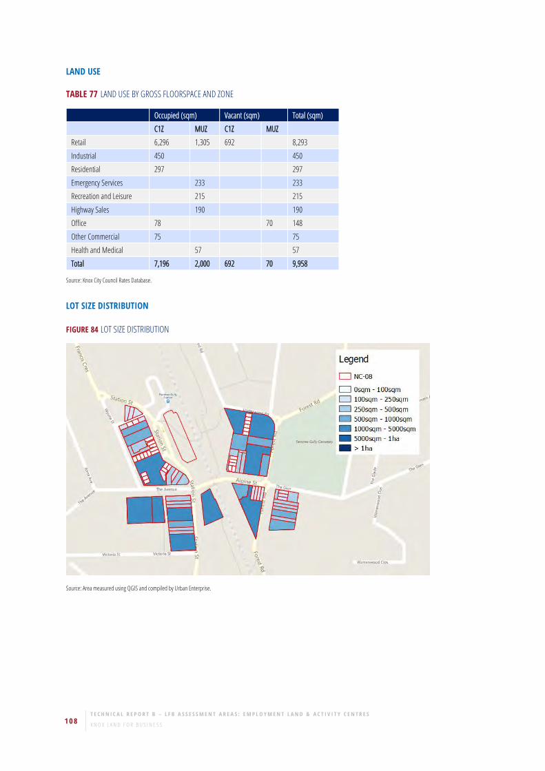
108 T E C H N I C A L R E P O R T B – L F B A S S E S S M E N T A R E A S : E M P L O Y M E N T L A N D & A C T I V I T Y C E N T R E S K N O X L A N D F O R B U S I N E S S
LAND USE
TABLE 77 LAND USE BY GROSS FLOORSPACE AND ZONE
Occupied (sqm) Vacant (sqm) Total (sqm) C1Z MUZ C1Z MUZ
Retail 6,296 1,305 692 8,293
Industrial 450 450
Residential 297 297
Emergency Services 233 233
Recreation and Leisure 215 215
Highway Sales 190 190
Office 78 70 148
Other Commercial 75 75
Health and Medical 57 57
Total 7,196 2,000 692 70 9,958
Source: Knox City Council Rates Database.
LOT SIZE DISTRIBUTION
FIGURE 84 LOT SIZE DISTRIBUTION
Source: Area measured using QGIS and compiled by Urban Enterprise.

U R B A N E N T E R P R I S E 109 J U L - 1 7
VACANT AND UNDERUTILISED SITES
FIGURE 85 LOCATION OF VACANT AND UNDERUTILISED SITES
Source: Knox City Council Rates Database and Aerial Imagery.
TABLE 78 VACANT AND UNDERUTILISED SITES BY AREA AND NUMBER OF LOTS
Site Area (sqm) No. of Lots
C1Z
Underutilised 3,963 3
Source: Knox City Council Rates Database and Aerial Imagery.

110 T E C H N I C A L R E P O R T B – L F B A S S E S S M E N T A R E A S : E M P L O Y M E N T L A N D & A C T I V I T Y C E N T R E S K N O X L A N D F O R B U S I N E S S
GROUND TRUTH
ROLE/BUSINESS MIX/EXAMPLE OF BUSINESSES
• NC-08 (Ferntree Gully Village) is centred around Ferntree Gully train station.
• There is a mix of convenience retail, retail services, speciality retail and food and beverage.
• NC-08 services the surrounding residential areas and captures trade from the train station.
• There are two convenience based supermarkets in NC-08 (IGA and Foodworks).
• Examples of businesses include hair and beauty, casual and take away food and beverage, groceries, pharmacy, post office, veterinary,
newsagency, florist and bakery;
• Strong community services / not for profit sector presence.
TYPE AND NUMBER OF BUSINESSES ON THE PERIPHERAL
Art gallery, learning centre, church, medical centre, kindergarten and cemetery.
KEY STRATEGIC REDEVELOPMENT SITES (IF ANY)
33 Forest Road.
10 Alpine Street.
Station Street (adjacent to rail station on west side).
ACCESSIBILITY
Direct access from Ferntree Gully Road – close to Burwood Highway.
Train station – heavily used by locals and commuters from further east.
Not on arterial road network – serves local catchment.

U R B A N E N T E R P R I S E 111 J U L - 1 7
30. NC-09: MOUNTAIN GATE CENTRAL ASSESSMENT AREA OVERVIEW
FIGURE 86 NC-09 ASSESSMENT AREA MAP BY ZONE
Source: Knox City Council and compiled by Urban Enterprise.
OTHER ASSESSMENT AREAS RELEVANT TO NC-09
BG-03, E-04
AREA AND FLOORSPACE
TABLE 79 SITE AREA AND GROSS FLOORSPACE BY ZONE
Land Area (sqm) Gross Floorspace (sqm)
C1Z 44,887 16,550
C2Z 42,031 12,955
Total 86,918 29,505
Source: Area measured using QGIS and Gross Floorspace from Knox City Council Rates Database.

112 T E C H N I C A L R E P O R T B – L F B A S S E S S M E N T A R E A S : E M P L O Y M E N T L A N D & A C T I V I T Y C E N T R E S K N O X L A N D F O R B U S I N E S S
LAND USE
TABLE 80 LAND USE BY GROSS FLOORSPACE AND ZONE
Occupied (sqm) Vacant (sqm) Total (sqm)
C1Z C2Z C1Z
Retail 12,742 8,845 968 22,555
Industrial 1,500 1,530 3,030
Highway Sales 1,985 1,985
Office 714 438 147 1,298
Pubs and Gaming 480 480
Residential 157 157
Total 15,435 12,955 1,115 29,505
Source: Knox City Council Rates Database.
LOT SIZE DISTRIBUTION
FIGURE 87 LOT SIZE DISTRIBUTION
Source: Area measured using QGIS and compiled by Urban Enterprise.

U R B A N E N T E R P R I S E 113 J U L - 1 7
VACANT AND UNDERUTILISED SITES
FIGURE 88 LOCATION OF VACANT AND UNDERUTILISED SITES
Source: Knox City Council Rates Database and Aerial Imagery.

114 T E C H N I C A L R E P O R T B – L F B A S S E S S M E N T A R E A S : E M P L O Y M E N T L A N D & A C T I V I T Y C E N T R E S K N O X L A N D F O R B U S I N E S S
GROUND TRUTH
ROLE/BUSINESS MIX/EXAMPLE OF BUSINESSES
• NC-09 is a large Neighbourhood Centre and consists of two separate centres. One is located along Ferntree Gully and the other is located
along Burwood Highway. NC-09 services the residential catchment of Ferntree Gully and captures passing trade from Burwood Highway
and Ferntree Gully Road.
• NC-09 along Ferntree Gully Road is anchored by two full line supermarkets (Coles and Woolworths) and is further supported by specialty
retailers, retail services, food and beverage and professional services.
• Examples of businesses along Ferntree Gully Road include Woolworths, Coles, banks, post office, pharmacy, florist, hair and beauty,
real estate agency, casual and take away food and beverage.
• NC-09 along Burwood Highway is an automotive retail assessment area that includes car dealerships, auto repairs and services.
• Examples of businesses along Burwood Highway include Hyundai, Kia, Beaurepaires and BP Service Station.
• Former zones included B3 and B4 areas – a variety of retail, restricted retail and industrial uses are now accommodated in this area.
TYPE AND NUMBER OF BUSINESSES ON THE PERIPHERY
New medical centre.
KEY STRATEGIC REDEVELOPMENT SITES (IF ANY)
Mountain Gate Triangle Strategic Investigation Site referred to in Knox Planning Scheme located partly in this assessment area.
ACCESSIBILITY
Direct access from Ferntree Gully Road and Burwood Highway.

U R B A N E N T E R P R I S E 115 J U L - 1 7
31. BG-01: FERNTREE GULLY (BURWOOD HWY CENTRAL) ASSESSMENT AREA OVERVIEW
FIGURE 89 BG-01 ASSESSMENT AREA MAP BY ZONE
Source: Knox City Council and compiled by Urban Enterprise.
OTHER ASSESSMENT AREAS RELEVANT TO BG-01
NC-04, BG-08
AREA AND FLOORSPACE
TABLE 81 SITE AREA AND GROSS FLOORSPACE BY ZONE
Land Area (sqm) Gross Floorspace (sqm)
C1Z 37,102 5,480
C2Z 57,832 20,284
Total 94,935 25,764
Source: Area measured using QGIS and Gross Floorspace from Knox City Council Rates Database.

116 T E C H N I C A L R E P O R T B – L F B A S S E S S M E N T A R E A S : E M P L O Y M E N T L A N D & A C T I V I T Y C E N T R E S K N O X L A N D F O R B U S I N E S S
LAND USE
TABLE 82 LAND USE BY GROSS FLOORSPACE AND ZONE
Occupied (sqm) Total (sqm) C1Z C2Z
Retail 7,024 7,024
Industrial 5,116 5,116
Education 4,154 4,154
Mixed Use Occupation 2,710 2,710
Residential 2,435 2,435
Commercial Accommodation 1,962 1,962
Pubs and Gaming 1,083 1,083
Highway Sales 610 610
Other Commercial 566 566
Religious 104 104
Total 5,480 20,284 25,764
Source: Knox City Council Rates Database.
LOT SIZE DISTRIBUTION
FIGURE 90 LOT SIZE DISTRIBUTION
Source: Area measured using QGIS and compiled by Urban Enterprise.

U R B A N E N T E R P R I S E 117 J U L - 1 7
VACANT AND UNDERUTILISED SITES
FIGURE 91 LOCATION OF VACANT AND UNDERUTILISED SITES
Source: Knox City Council Rates Database and Aerial Imagery.
TABLE 83 VACANT AND UNDERUTILISED SITES BY AREA AND NUMBER OF LOTS
Site Area (sqm) No. of Lots
C1Z
Vacant 6,476 3
Underutilised 25,690 5
Total 32,166 8
Source: Knox City Council Rates Database and Aerial Imagery.

118 T E C H N I C A L R E P O R T B – L F B A S S E S S M E N T A R E A S : E M P L O Y M E N T L A N D & A C T I V I T Y C E N T R E S K N O X L A N D F O R B U S I N E S S
GROUND TRUTH
ROLE/BUSINESS MIX/EXAMPLE OF BUSINESSES
• BG-01 is a significant bulky goods retail area along Burwood Highway. BG-01 includes a number of automotive retail and service
businesses, as well as a mix of home improvement/renovation, discount retail and food and beverage.
• Automotive retailers include Toyota, Ferntree Gully Truck and Car Services, Widetread Tyres, Auto Barn and JZ Motors.
• Other businesses include Le Pine Funerals, service station, bicycle store, heating and cooling, Ferntree Gully Hotel and discount retail.
• Rezoning of a former Business 5 area to the north of Burwood Highway has created a Commercial 1 Zone area with medium density
dwellings and underutilised sites disconnected from other retail / commercial uses.
TYPE AND NUMBER OF BUSINESSES ON THE PERIPHERY
Adjoins NC-04 and E-08.
KEY STRATEGIC REDEVELOPMENT SITES (IF ANY)
Ferntree Gully Auto Salvage.
1135 Burwood Highway and 1125-1127 Burwood Highway – residential opportunities, consider rezoning.
ACCESSIBILITY
Direct access from Burwood Highway.

U R B A N E N T E R P R I S E 119 J U L - 1 7
32. BG-02: MOUNTAIN GATE TRIANGLE ASSESSMENT AREA OVERVIEW
FIGURE 92 BG-03 ASSESSMENT AREA MAP BY ZONE
Source: Knox City Council and compiled by Urban Enterprise.
OTHER ASSESSMENT AREAS RELEVANT TO BG-02
NC-09
AREA AND FLOORSPACE
TABLE 84 SITE AREA AND GROSS FLOORSPACE BY ZONE
Land Area (sqm) Gross Floorspace (sqm)
C2Z 199,238 70,465
Source: Area measured using QGIS and Gross Floorspace from Knox City Council Rates Database.

120 T E C H N I C A L R E P O R T B – L F B A S S E S S M E N T A R E A S : E M P L O Y M E N T L A N D & A C T I V I T Y C E N T R E S K N O X L A N D F O R B U S I N E S S
LAND USE
TABLE 85 LAND USE BY GROSS FLOORSPACE AND ZONE
Occupied (sqm) Vacant (sqm) Total (sqm) C2Z C2Z
Retail 34,335 565 34,900
Industrial 30,414 2,326 32,740
Highway Sales 1,192 1,192
Education 773 773
Residential 338 338
Pubs and Gaming 208 208
Other Commercial 155 155
Office 129 129
Infrastructure and Utility 30 30
Total 67,574 2,891 70,465
Source: Knox City Council Rates Database.
LOT SIZE DISTRIBUTION
FIGURE 93 LOT SIZE DISTRIBUTION
Source: Area measured using QGIS and compiled by Urban Enterprise.

U R B A N E N T E R P R I S E 121 J U L - 1 7
VACANT AND UNDERUTILISED SITES
FIGURE 94 LOCATION OF VACANT AND UNDERUTILISED SITES
Source: Knox City Council Rates Database and Aerial Imagery.
TABLE 86 VACANT AND UNDERUTILISED SITES BY AREA AND NUMBER OF LOTS
Site Area (sqm) No. of Lots
C2Z
Vacant 1,023 1
Source: Knox City Council Rates Database and Aerial Imagery.

122 T E C H N I C A L R E P O R T B – L F B A S S E S S M E N T A R E A S : E M P L O Y M E N T L A N D & A C T I V I T Y C E N T R E S K N O X L A N D F O R B U S I N E S S
GROUND TRUTH
ROLE/BUSINESS MIX/EXAMPLE OF BUSINESSES
• BG-02 is a significant bulky goods retail area along Burwood Highway. BG-02 is anchored by home improvement and furniture retailers,
car dealerships and automotive retailers.
• Examples of home improvement and furniture businesses within BG-02 include Shine Kitchen and Bathroom, Beaumont Tiles, Burdens
Bathrooms, Carpet Call and Snooze.
• Automotive retailers / businesses include Ford, Fiat, Jeep, Dodge, Chrysler, Nissan, Great Wall, Tata Motors, Budget Car and Truck Rental
and Autobarn.
• Other businesses include Officeworks, Anytime Fitness, Salvation Army and Pet Barn.
TYPE AND NUMBER OF BUSINESSES ON THE PERIPHERY
None identified.
KEY STRATEGIC REDEVELOPMENT SITES (IF ANY)
Vacant showrooms adjoining Anytime Fitness.
This assessment area and part of NC-09 make up the Mountain Gate Triangle Strategic Investigation Site identified in Knox Planning Scheme.
ACCESSIBILITY
Dual access from Burwood Highway and Ferntree Gully Road.
Can be difficult to navigate throughout the assessment area.
Excellent exposure to arterial roads.

U R B A N E N T E R P R I S E 123 J U L - 1 7
33. BG-03: KNOXFIELD BUNNINGS ASSESSMENT AREA OVERVIEW
FIGURE 95 BG-03 ASSESSMENT AREA MAP BY ZONE
Source: Knox City Council and compiled by Urban Enterprise.
OTHER ASSESSMENT AREAS RELEVANT TO BG-03
E-05
AREA AND FLOORSPACE
TABLE 87 SITE AREA AND GROSS FLOORSPACE BY ZONE
Land Area (sqm) Gross Floorspace (sqm)
C2Z 34,359 12,515
Source: Area measured using QGIS and Gross Floorspace from Knox City Council Rates Database.
LAND USE
TABLE 88 LAND USE BY GROSS FLOORSPACE AND ZONE
Occupied (sqm) Total (sqm)
C2Z
Retail 12,515 12,515
Source: Knox City Council Rates Database.
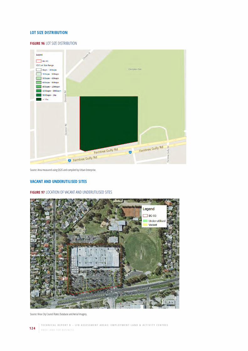
124 T E C H N I C A L R E P O R T B – L F B A S S E S S M E N T A R E A S : E M P L O Y M E N T L A N D & A C T I V I T Y C E N T R E S K N O X L A N D F O R B U S I N E S S
LOT SIZE DISTRIBUTION
FIGURE 96 LOT SIZE DISTRIBUTION
Source: Area measured using QGIS and compiled by Urban Enterprise.
VACANT AND UNDERUTILISED SITES
FIGURE 97 LOCATION OF VACANT AND UNDERUTILISED SITES
Source: Knox City Council Rates Database and Aerial Imagery.

U R B A N E N T E R P R I S E 125 J U L - 1 7
GROUND TRUTH
ROLE/BUSINESS MIX/EXAMPLE OF BUSINESSES
• BG-03 includes a stand-alone Bunnings Warehouse.
TYPE AND NUMBER OF BUSINESSES ON THE PERIPHERY
Carrington Park Family Leisure Centre.
KEY STRATEGIC REDEVELOPMENT SITES (IF ANY)
None.
ACCESSIBILITY
Direct access from Ferntree Gully Road.

126 T E C H N I C A L R E P O R T B – L F B A S S E S S M E N T A R E A S : E M P L O Y M E N T L A N D & A C T I V I T Y C E N T R E S K N O X L A N D F O R B U S I N E S S
34. BG-04: KNOXFIELD (SOUTH FERNTREE GULLY RD) ASSESSMENT AREA OVERVIEW
FIGURE 98 BG-04 ASSESSMENT AREA MAP BY ZONE
Source: Knox City Council and compiled by Urban Enterprise.
OTHER ASSESSMENT AREAS RELEVANT TO BG-04
E-05, SS-11
AREA AND FLOORSPACE
TABLE 89 SITE AREA AND GROSS FLOORSPACE BY ZONE
Land Area (sqm) Gross Floorspace (sqm)
C2Z 50,695 22,508
Source: Area measured using QGIS and Gross Floorspace from Knox City Council Rates Database.

U R B A N E N T E R P R I S E 127 J U L - 1 7
LAND USE
TABLE 90 LAND USE BY GROSS FLOORSPACE AND ZONE
Occupied (sqm) Total (sqm)
C2Z
Retail 9,616 9,616
Industrial 9,315 9,315
Recreation and Leisure 2,749 2,749
Highway Sales 828 828
Total 22,508 22,508
Source: Knox City Council Rates Database.
LOT SIZE DISTRIBUTION
FIGURE 99 LOT SIZE DISTRIBUTION
Source: Area measured using QGIS and compiled by Urban Enterprise.

128 T E C H N I C A L R E P O R T B – L F B A S S E S S M E N T A R E A S : E M P L O Y M E N T L A N D & A C T I V I T Y C E N T R E S K N O X L A N D F O R B U S I N E S S
VACANT AND UNDERUTILISED SITES
FIGURE 100 LOCATION OF VACANT AND UNDERUTILISED SITES
Source: Knox City Council Rates Database and Aerial Imagery.
GROUND TRUTH
ROLE/BUSINESS MIX/EXAMPLE OF BUSINESSES
• BG-04 includes electrical appliance, and home and building supply warehouses/showrooms.
• BG-04 also includes automotive retailers.
• Examples of businesses include Miele, garden and building supplies, indoor play/sport centre and a ducted vacuum centre.
TYPE AND NUMBER OF BUSINESSES ON THE PERIPHERY
Physiotherapist.
KEY STRATEGIC REDEVELOPMENT SITES (IF ANY)
None.
ACCESSIBILITY
Direct access from Ferntree Gully Road (service road) – good exposure.
Limited car parking provision.

U R B A N E N T E R P R I S E 129 J U L - 1 7
35. BG-05: EASTLINK TRIANGLE ASSESSMENT AREA OVERVIEW
FIGURE 101 BG-05 ASSESSMENT AREA MAP BY ZONE
Source: Knox City Council and compiled by Urban Enterprise.
OTHER ASSESSMENT AREAS RELEVANT TO BG-05
AC-02, HP-01
AREA AND FLOORSPACE
TABLE 91 SITE AREA AND GROSS FLOORSPACE BY ZONE
Land Area (sqm) Gross Floorspace (sqm)
C2Z 22,631 6,572
Source: Area measured using QGIS and Gross Floorspace from Knox City Council Rates Database.

130 T E C H N I C A L R E P O R T B – L F B A S S E S S M E N T A R E A S : E M P L O Y M E N T L A N D & A C T I V I T Y C E N T R E S K N O X L A N D F O R B U S I N E S S
LAND USE
TABLE 92 LAND USE BY GROSS FLOORSPACE AND ZONE
Occupied (sqm) Total (sqm)
C2Z
Religious 4,528 4,528
Industrial 2,004 2,004
Total 6,572 6,572
Source: Knox City Council Rates Database.
LOT SIZE DISTRIBUTION
FIGURE 102 LOT SIZE DISTRIBUTION
Source: Area measured using QGIS and compiled by Urban Enterprise.

U R B A N E N T E R P R I S E 131 J U L - 1 7
VACANT AND UNDERUTILISED SITES
FIGURE 103 LOCATION OF VACANT AND UNDERUTILISED SITES
Source: Knox City Council Rates Database and Aerial Imagery.
GROUND TRUTH
ROLE/BUSINESS MIX/EXAMPLE OF BUSINESSES
• BG-05 includes a Religious and Education Centre
• BG-05 also includes a modern industrial warehouse at the rear of the site
TYPE AND NUMBER OF BUSINESSES ON THE PERIPHERY
Museum, Industrial supplies
KEY STRATEGIC REDEVELOPMENT SITES (IF ANY)
Vacant land on the site.
ACCESSIBILITY
Access from north and south of the site.
Located next to on and off-ramps of EastLink.

132 T E C H N I C A L R E P O R T B – L F B A S S E S S M E N T A R E A S : E M P L O Y M E N T L A N D & A C T I V I T Y C E N T R E S K N O X L A N D F O R B U S I N E S S
36. STRIP SHOPS AREA AND FLOORSPACE
TABLE 93 SITE AREA AND GROSS FLOORSPACE BY ZONE
Code &
Zones Name of Assessment Area Location/Address Site Area (sqm) Gross Floorspace (sqm)
SS-01 Stamford Stud Rd & Wellington Rd (north west
side) 35,223 3,234
C1Z 35,223 3,234
SS-02 Studfield Shopping Centre (Wantirna) Stud Rd, Coleman Rd & Somerset Rd 7,463 6,920
C1Z 7,463 6,920
SS-03 Stud Bay (Stud Rd, north of Leonard St) Stud Rd, Leonards Rd & Phyllis St 2,738 1,662
C1Z 2,738 1,662
SS-04 Mountain Hwy/Kumala Rd Mountain Hwy & Kumala Rd 2,614 1,609
C1Z 2,614 1,609
SS-05 Boronia Rd/Scoresby Rd Scoresby Rd & Boronia Rd 10,378 2,051
C1Z 10,378 2,051
SS-06 The Basin Basin-Olinda Rd, Mountain Hwy & Forest
Rd, The Basin 9,798 2,917
C1Z 9,798 2,917
SS-07 Alchester Village Mountain Hwy & Albert Ave 6,969 2,932
C1Z 6,969 2,932
SS-08 Lewis Rd/Coleman Rd Coleman Rd & Lewis Rd 1,708 808
C1Z 1,708 808
SS-09 Fairhills Shops (Manuka Dr/Loretta Ave) Manuka Rd & Loretto Ave 725 656
C1Z 725 470
PUZ2 0 186
SS-10 Knox Gardens High St & Fonteyn Dr 3,016 2,254
C1Z 3,016 2,254
SS-11 Knoxfield Shops Kathryn Rd & Knox Pl 4,353 2,532
C1Z 4,353 2,532
SS-12 Glenfern Rd/Mason St Glenfern Rd & Mason St 1,710 860
C1Z 1,710 860
SS-13 Anne Rd Anne Rd & Kathryn Rd 913 651
C1Z 913 651
SS-14 Dorset Rd/Landscape Dr Dorset Rd, Bellevue Ct 2,616 1,018
C1Z 2,616 1,018
SS-15 Cavell St/Armin St Cavell St, Armin St 781 404
C1Z 781 404
SS-16 Bunnett Rd/Burwood Hwy Burwood Hwy 1,952 925
C1Z 1,952 925
Source: Area measured using QGIS and Gross Floorspace from Knox City Council Rates Database.

U R B A N E N T E R P R I S E 133 J U L - 1 7
LAND USE
TABLE 94 LAND USE BY GROSS FLOORSPACE AND ZONE
Occupied (sqm) Occupied Total (sqm) Vacant (sqm) Vacant Total (sqm) Total (sqm) C1Z PUZ2 C1Z PUZ2
SS-01 3,234 3,234 3,234
Retail 1,692 1,692 1,692
Pubs and Gaming 1,542 1,542 1,542
SS-02 6,755 6,755 165 165 6,920
Retail 5,550 5,550 165 165 5,715
Office 1,205 1,205 1,205
SS-03 1,551 1,551 111 111 1,662
Retail 1,149 1,149 111 111 1,260
Office 402 402 402
SS-04 1,103 1,103 506 506 1,609
Retail 1,103 1,103 506 506 1,609
SS-05 2,051 2,051 2,051
Retail 1,831 1,831 1,831
Highway Sales 220 220 220
SS-06 2,750 2,750 167 167 2,917
Retail 2,352 2,352 167 167 2,519
Highway Sales 218 218 218
Pubs and Gaming 180 180 180
SS-07 2,852 2,852 81 81 2,932
Retail 2,778 2,778 81 81 2,858
Office 74 74 74
SS-08 644 644 164 164 808
Retail 644 644 164 164 808
SS-09 470 100 570 86 86 656
Retail 369 369 86 86 455
Residential 101 100 201 201
SS-10 2,254 2,254 2,254
Retail 2,254 2,254 2,254
SS-11 2,532 2,532 2,532
Retail 2,326 2,326 2,326
Office 206 206 206
SS-12 860 860 860
Retail 860 860 860
SS-13 522 522 129 129 651
Retail 522 522 129 129 651
SS-14 1,018 1,018 1,018
Retail 1,018 1,018 1,018
SS-15 197 197 210 210 407
Office 197 197 197
Retail 210 210 210
SS-16 925 925 925
Highway Sales 925 925 925
Total 29,717 100 29,817 1,532 86 1,618 31,435
Source: Knox City Council Rates Database, Knox City Council 2016

134 T E C H N I C A L R E P O R T B – L F B A S S E S S M E N T A R E A S : E M P L O Y M E N T L A N D & A C T I V I T Y C E N T R E S K N O X L A N D F O R B U S I N E S S
SS-01
ROLE/BUSINESS MIX/EXAMPLE OF BUSINESSES
• Fragmented configuration
• SS-01 includes a service station, 7-11, Dany Murphy’s and a pub/bistro.
ACCESSIBILITY
Located at the Stud Road and Wellington Road intersection. Access from both Roads.
TYPE AND NUMBER OF BUSINESSES ON THE PERIPHERY
Commercial development across Stud Road in residential zone.
KEY STRATEGIC REDEVELOPMENT SITES (IF ANY)
Land has potential for redevelopment. Further strategic investigation would be appropriate.
SS-02
ROLE/BUSINESS MIX/EXAMPLE OF BUSINESSES
• SS-02 is anchored by a small supermarket (IGA).
• SS-02 includes some convenience based retail, speciality retail, retail services and food and beverage.
• Examples of businesses include real estate agencies, post office, banks, butcher, bakery, pharmacy and casual and take away food and
beverage.
ACCESSIBILITY
Direct access from Stud Road.
Sufficient car parking provision.
SS-03
ROLE/BUSINESS MIX/EXAMPLE OF BUSINESSES
• SS-03 is a small retail strip, which includes convenience based retail and causal and take away food and beverage.
• SS-03 includes a medical centre.
ACCESSIBILITY
Direct access from road.
Sufficient car parking provision.

U R B A N E N T E R P R I S E 135 J U L - 1 7
SS-04
ROLE/BUSINESS MIX/EXAMPLE OF BUSINESSES
• Small retail strip, which includes specialty retail and retail services (hair dresser and Laundromat).
• SS-04 has a small number of vacancies.
ACCESSIBILITY
Access via road/service road off main street.
SS-05
ROLE/BUSINESS MIX/EXAMPLE OF BUSINESSES
• SS-05 includes a small number of convenience stores and take away/fast food and beverage.
• SS-05 also includes a local government office, veterinary and service station.
ACCESSIBILITY
Ease of access and sufficient car parking provision.
SS-06
ROLE/BUSINESS MIX/EXAMPLE OF BUSINESSES
• SS-06 includes retail services and casual and take away food and beverage.
ACCESSIBILITY
On-street parking (90 degree).
SS-07
ROLE/BUSINESS MIX/EXAMPLE OF BUSINESSES
• SS-07 is anchored by a small supermarket (IGA) and supported by food and beverage, convenience retail, medical and professional
services.
• SS-07 services E-09 and local residents.
ACCESSIBILITY
Direct access from road with sufficient car parking provision.
SS-08
ROLE/BUSINESS MIX/EXAMPLE OF BUSINESSES
• SS-08 consists of convenience retail and take away food and beverage.
• Businesses include a milkbar, bottleshop and hairdresser

136 T E C H N I C A L R E P O R T B – L F B A S S E S S M E N T A R E A S : E M P L O Y M E N T L A N D & A C T I V I T Y C E N T R E S K N O X L A N D F O R B U S I N E S S
ACCESSIBILITY
Direct access with a limited car parking provision.
SS-09
ROLE/BUSINESS MIX/EXAMPLE OF BUSINESSES
• SS-09 includes convenience retail and take away food and beverage.
• Examples of businesses include a milk bar, fish and chips, childcare centre and 2 retail vacancies.
ACCESSIBILITY
Located on a quiet street with sufficient car parking provision.
SS-10
ROLE/BUSINESS MIX/EXAMPLE OF BUSINESSES
• SS-10 is anchored by a Foodworks and Asian grocer and is further supported by a chemist, convenience retail and casual food and
beverage.
ACCESSIBILITY
Front and rear access.
KEY STRATEGIC REDEVELOPMENT SITES (IF ANY)
Land adjoining at 1332 High Street Road, which was a video store and now a fitness centre, is for all purposes part of the strip shopping centre
but zoned residential. Consider rezoning to C1Z.
SS-11
ROLE/BUSINESS MIX/EXAMPLE OF BUSINESSES
• SS-11 includes an IGA and is supported by a retail services (post office, chemist) and take away food and beverage.
ACCESSIBILITY
Access from main road to either side of a carpark.
SS-12
ROLE/BUSINESS MIX/EXAMPLE OF BUSINESSES
• SS-12 is a small strip of shops located on Glenfern Road and includes convenience retail and take away food and beverage.
• Businesses include fish and chips, liquor store, milk bar, day spa, bakery and dentist.

U R B A N E N T E R P R I S E 137 J U L - 1 7
SS-13
ROLE/BUSINESS MIX/EXAMPLE OF BUSINESSES
• Strip shop in residential neighbourhood, away from main road.
• Characterized by convenience store, health clinic and takeaway food store.
ACCESSIBILITY
Good access for local neighbourhood, with 90-degree car parks along strips.
SS-14
ROLE/BUSINESS MIX/EXAMPLE OF BUSINESSES
• Small strip with specialty shops (2) and a takeaway.
• Supports E-01.
ACCESSIBILITY
Easy carpark access. Carpark has been extended.
SS-15
ROLE/BUSINESS MIX/EXAMPLE OF BUSINESSES
Community centre operated by religious group.
ACCESSIBILITY
Five car parks.
Access to Stud Rd.
SS-16
ROLE/BUSINESS MIX/EXAMPLE OF BUSINESSES
Chemist Warehouse.
ACCESSIBILITY
Located on Burwood Highway.
Approximately 28 car parks on-site

138 T E C H N I C A L R E P O R T B – L F B A S S E S S M E N T A R E A S : E M P L O Y M E N T L A N D & A C T I V I T Y C E N T R E S K N O X L A N D F O R B U S I N E S S
VACANT AND UNDERUTILISED SITES
TABLE 95 VACANT AND UNDERUTILISED SITES BY AREA AND NUMBER OF LOTS
Row Labels Site Area (sqm) No. of Lots
SS-01
C1Z
Underutilised 35,223 1
SS-06
C1Z
Underutilised 1,931 3
SS-08
C1Z
Vacant 189 1
Total 39,685 6
Source: Knox City Council Rates Database and Aerial Imagery, Knox City Council 2016

U R B A N E N T E R P R I S E 139 J U L - 1 7
37. PLANNING PERMITS HISTORICAL PLANNING PERMITS 2010 – APRIL 2016
TABLE 96 HISTORICAL PLANNING PERMITS - NEW DEVELOPMENT AND CHANGE OF USE, BY PREVIOUS ZONES, 2010 – APRIL 2016
Buildings and Works 2010 –April 2016
B1Z
Mixed Use (Residential, Retail and Commercial) 1
Warehouse 1
B2Z
Car Sales 1
Medical 1
B3Z
Indoor Recreation 1
Office 1
Warehouse 2
B4Z
Place of Assembly 1
Warehouse 1
IN1Z
Ambulance Branch 1
Manufacturing 1
Milk depot 1
Office 2
Office and warehouse 8
Restricted Retail 1
Retail 2
Warehouse 19
Total New Buildings and Works 45
Change of Use
B1Z
Car Sales 1
Education 2
Food and Drink 2
Medical 1
Motor Repair 1
Office 1
Restricted Recreation Facility 4
Retail 1
Trade supplies 1
Vet 1
B2Z
Education 1
Food and Drink 1
Restricted Recreation Facility 1
Service Retail 1
B3Z
Animal Keeping 1
Car Hire 1
Education 5
Food and Drink 1
Indoor Recreation 5

140 T E C H N I C A L R E P O R T B – L F B A S S E S S M E N T A R E A S : E M P L O Y M E N T L A N D & A C T I V I T Y C E N T R E S K N O X L A N D F O R B U S I N E S S
Place of Assembly 2
Restricted Recreation Facility 3
Trade supplies 1
B4Z
Education 1
Manufacturing 1
Restricted Recreation Facility 1
IN1Z
Animal Husbandry 1
Car Sales 8
CFA 1
Education 2
Food and Drink 1
Indoor Recreation 4
Leisure and Recreation 1
Manufacturing 6
Other 1
Office 1
Office and Restricted Place of Assembly 1
Place of Assembly 6
Place of Worship 5
Recycling 1
Restricted Recreation Facility 16
Retail 1
Trade supplies 5
Waste Treatment 1
MUZ
Restricted Recreation Facility 1
Office 2
B3Z
Office 2
Warehouse and or Store 15
B3Z
Warehouse 2
IN1Z
Car Repairs 1
Office and warehouse 7
Warehouse 5
Total Change of Use 104
Grand Total 166
Source: Planning Permits 2010-2016, Knox City Council, 2016

U R B A N E N T E R P R I S E 141 J U L - 1 7
POTENTIALLY APPROVED PLANNING PERMITS
TABLE 97 POTENTIALLY APPROVED PLANNING PERMITS - NEW DEVELOPMENT AND CHANGE OF USE
Building and works No. of Permit
C1Z
Aged Care 1
Mixed Use (Residential, Retail and Commercial) 1
C2Z
Office 1
Retail 1
Warehouse 1
GRZ2
Medical 1
IN1Z
Food and Drinks 1
Medical and Office 1
Office and Warehouse 1
Place of Worship 2
Warehouse 2
LDRZ
Aged Care 1
MUZ
Mixed Use (Residential, Retail and Commercial) 1
NRZ1
Service Station 1
PUZ1
Supermarket 1
PUZ4
Supermarket 1
RGZ1
Mixed Use (Residential, Retail and Commercial) 1
Total Buildings and works 19
Change of Use
GRZ2
Child Care 1
Total change in use 1
Grand total 20
Source: Knox City Council 2016
HISTORICAL PLANNING PERMIT BY LAND TAKE 2010 - 2016
TABLE 98 HISTORICAL PLANNING PERMITS BY LAND TAKE (SQM) 2010 - 2016
2010 2011 2012 2013 2014 2015 2016 Total Land Take (sqm)
C1Z 1,256 1,651 3,775 1,974 111 509 0 9,276
C2Z 0 1,058 1,012 21,043 13,372 37,713 75,500 149,698
IN1Z 24,906 53,548 70,542 10,081 49,457 91,316 13,159 313,009
Total 26,162 56,257 75,329 33,098 62,940 129,538 88,659 471,983
Source: Planning Permits by Land Take 2010-2016, Knox City Council