Embed Size (px)
Citation preview
Land markets, property rights, and deforestation in Indonesia
Vijesh Krishna & Matin Qaim, Georg-August University of Göttingen; Unai Pascual, Basque Centre for Climate Change
Paper to be presented at the Joint University of California Davis & Georg-August University of Göttingen Workshop: Current Topics in Agricultural Economic Research
Abstract: The paper examines the emergence and functioning of land markets and possible
implications for deforestation in Sumatra, Indonesia, using micro-level data. While the
evolution of land markets is generally expected to enhance deforestation, we do not
observe such association, mainly due to two reasons. First, land market transactions occur
in cultural and spatial isolation from forest land appropriation. Residents of transmigrant
villages are found more involved in land market transactions than those of autochthonous
villages. The plots that are traded in the market also differ from the plots that are
developed through direct appropriation, especially with respect to their location. Second,
the emergence of speculative land markets, which could accelerate deforestation, is evaded
through institutional constraints, primarily weak property rights. The de facto property right
protection under customary law might be providing sufficient internal tenure security for
most households; but the sense of external tenure security is low for the land that cannot
be titled, leading to undervaluation of directly appropriated forest land. Clearing the forest
land for trading in the land market is financially less lucrative for the farmers than engaging
in cultivation of plantation crops in the converted land. We observe that while land markets
under low external tenure security have not enhanced deforestation in Sumatra, they have
been also unable to deter forest appropriation.
1. Introduction
Population and income growth, often together with other economic factors, tend to
increase the demand for land resources for agricultural production (Platteau, 1996; Hertel,
Ramankutty, & Baldos, 2014). In the absence of strong institutions and policies, the
resulting land scarcity instigates conversion of natural forest land, especially in the global
South (Bhattarai & Hammig, 2001). An estimated 83 percent of all agricultural land added
in the tropics during the 1980s and 1990s were derived from either intact or disturbed
forests (Gibbs et al., 2010). Since forests embody key ecological and geo-climatic functions,
deforestation has become a major concern and the cornerstone of global policy initiatives
(Pülzl & Rametsteiner, 2002; Phelps et al., 2013).
‐ 2 ‐
While deforestation in developing countries is driven by economic needs and opportunities
coupled with various institutional constraints (World Bank, 2007), many of the patterns of
association remain under-examined. In this article, we are particularly interested in the role
of land markets. Farmers in developing countries access land through different pathways,
including inheritance and inter-vivo transfers, community membership, appropriation of
state forest land, market transactions, and occasionally coercive or non-coercive state
interventions (de Janvry & Sadoulet, 2001). Building on the evolutionary theories of
property rights (e.g., Demsetz, 1967), increasing land scarcity could potentially lead to a
shift from common property to individual property rights regimes with land market
transactions becoming more prominent for farmers to acquire cultivable land (Platteau,
1996; Fitzpatrick, 2006). Some argue that this evolution could be an efficient mechanism to
allocate land to its most productive use (Zimmerman & Carter, 1999; Wallace &
Williamson, 2006), although others contend that institutional constraints may prevent
economically and socially desirable outcomes (Deininger, Jin, & Nagarajan, 2009; Holden,
Otsuka, & Place, 2009; Deininger & Jin, 2008).
There exists a large body of literature analysing the conceptual relationship between land
market development and forest conservation (e.g. Barbier, 2001; Bhattarai & Hammig,
2001; Geist & Lambin, 2002). There are also several empirical studies that have investigated
farmers’ participation in land markets (e.g., Deininger, Zegarra, & Lavadenz, 2003;
Deininger & Jin, 2008; Deininger, Jin, & Nagarajan, 2009). However, there is little empirical
evidence on the effect of land market development on deforestation. This effect is not
straightforward to predict because the emergence of land markets often coincides with the
emergence of private property rights, and the effect of private property rights on
deforestation itself is not unambiguous (Alston, Libecap, & Schneider, 1996; Godoy, Kirby,
& Wilkie, 2001; Place & Otsuka, 2001; Araujo et al., 2009; Liscow, 2013). On the one hand,
stronger property rights and tenure security could prompt landholders to discount the
future less, thus being more likely to realize long-term benefits of forests as opposed to
short-term benefits of agriculture. On the other hand, stronger property rights could also
increase incentives to invest in productive activities such as agriculture. A recent meta-
analysis indicates a negative association between land tenure security and the rate of
deforestation (Robinson, Holland, & Naughton-Treves, 2014). However, the empirical
results vary by context and the role of land markets was not explicitly considered.

‐ 3 ‐
We address this gap in the empirical literature focusing on Indonesia, which like many
other tropical regions, has experienced a rapid depletion of forest resources in favour of a
fast expanding agrarian sector (MoF, 2009; FAO, 2010; Margono et al., 2012; Barraclough,
2013). Over the last decade, a large share of deforestation in Indonesia has been driven by
large-scale companies (88 percent during 2000-2010) and to lesser extent by smallholder
farmers (11 percent) (Lee et al., 2014). Nevertheless, the decentralized activities by
smallholders are much more difficult to monitor and regulate and hence become a critical
challenge for forest conservation (Indrarto et al., 2012). This is also the reason why we
focus on smallholder land acquisition decisions in this research. To our knowledge, the role
of land markets for deforestation has not previously been analysed in Indonesia, in spite of
the fact that national and international agencies have launched various programs to
strengthen land markets in the country.
Micro-level empirical studies are an important complement to global models to analyse
drivers of land use changes (Meyfroidt et al., 2013). Here we report on results from micro-
level data collected through a survey of smallholder farm households in Sumatra to address
two related questions: (i) how do land markets evolve over time as a pathway of land
acquisition for smallholders under a scenario of increasing land scarcity? and (ii) does
participation in land markets influence farmers’ decisions to engage in deforestation
activities? Nowadays, most farmers in the study region grow oil palm and rubber, with only
relatively little forest land left. The household survey was conducted in Jambi Province in
Sumatra. Land use in Jambi has undergone significant changes during the last three
decades, including the conversion of primary forests to rubber agroforests and later to
intensive rubber and oil palm plantations (Wilcove et al., 2013). About 43 percent of the
2.7 million ha of primary forest in 1990 was lost in Jambi by 2010 (Margono et al., 2012).
While different private and public companies are producing oil palm in Jambi on large
landholdings, smallholder farmers dominate the rubber sector and are also involved in oil
palm cultivation to a significant extent (Euler et al., 2015; Gatto, Wollni, & Qaim, 2015).
While the survey was conducted in 2012, the questionnaire sought information on
households’ history of land acquisition, thus enabling us to track land use changes over
several decades at the individual plot level.
The next section provides background information about Indonesia’s evolving land
governance system and the observed socio-demographic heterogeneity in Sumatra. The
conceptual framework and the main research hypotheses are presented in section 3, while

‐ 4 ‐
section 4 describes the data sources and the methods of data analysis. The empirical results
are presented and discussed in section 5, and the final section concludes.
2. Background
2.1. The evolution of land governance in Indonesia
In Indonesia, the indigenous legal systems based on adat (customary law) were prevalent
both during the Dutch colonial rule (before 1945) and the early independence era
(Szczepanski, 2002). Adat is largely unwritten and forms part of oral history of different
ethnic groups. One of the most important legislations on land governance during the post-
independence era is the Basic Agrarian Law (BAL), which was enacted in 1960 under
Sukarno’s government. The BAL was primarily aimed at unifying all the land laws of
Indonesia into a single system, and it recognizes adat rights under the condition that these
rights do not collide with wider national interests. Different forms of registrable interest
(qualified for obtaining land titles) in private land are also possible under the BAL,
alongside community property rights (Lindsey, 1998). Nevertheless, due to the relative
abundance of land in Sumatra and other outer islands of Indonesia, incentives for the
development of land markets were rather limited in the past (Slaats et al., 2009).
A significant shift in land governance occurred under the ‘New Order Regime’ (1967-1998)
under Indonesia’s second president, Suharto. Specifically, legislations enabling forestry and
mining leases were enacted, including the Forestry Law of 1967, which set the framework
for forest management for the following three decades. This law entailed a disenfranchising
of the rural population from forest resources (Haverfield, 1999). Around 70 percent of the
country’s territory, designated as forest land and previously governed by the National Land
Agency, became under the jurisdiction of the Ministry of Forestry (Indrarto et al., 2012).
Unregistered plots, including many under cultivation, were regarded as a form of state
forest land (kawasan hutan). In fact, the Indonesian government seldom recognizes the land
rights of farmers over illegally converted forest land. However, even in the absence of any
legal recognition, farm households claim de facto use and ownership rights by clearing forest
for crop production (Johnson & Nelson, 2004; Peluso, 2005). In fact, there exists a strong
conviction by farm households that such de facto tenure is secure at least within the
community (Resosudarmo et al., 2013).
‐ 5 ‐
The provision of land titles is a key institutional factor on which the evolution of land
markets depends. While certain forms of land titles were possible under the BAL, market
transactions of titled land hardly occurred in Indonesia till the 1980s. In 1981, the
Indonesian government introduced the National Agrarian Operation Project (PRONA)
land titling program to increase the land area with titles while reducing transaction costs
involved in the titling process. Still, by the end of the 20th century only less than 20 percent
of all registrable plots (about 10 percent in rural areas) had actually been titled (Fitzpatrick,
1997; Slaats et al., 2009). From the early 1990s, the Government of Indonesia intensified
efforts to develop a reliable land titling system over non-forest land. PRONA was largely
replaced by the Land Administration Project (LAP), funded by the World Bank and the
Australian Government. About 2 million plots of land were registered, mostly in West Java,
during the first phase of LAP (Reerink & van Gelder, 2010). The objective of LAP is to
title all agrarian land in Indonesia by 2020 (Thorburn, 2004). The underlying assumption of
these policies is that community-based titling is inherently ineffective in ensuring economic
development and reducing deforestation rates (Lindsey, 1998; USAID, 2010).
Under the current land governance system in Indonesia, two types of land titling are
possible for agrarian land: (i) systematic titling, where a large number of contiguous plots
across different users can be registered at a subsidized rate, and (ii) sporadic titling, where a
single landholder applies for the title (USAID, 2010). While PRONA primarily involved
sporadic titling, LAP aims for systematic titling (Slaats et al., 2009). At present, farmers can
apply for both options. Although systematic titles are generally considered as more secure,
the application requires greater amount of supporting documents from land-owners and
hence the process could be time-consuming. However, many farmers still prefer systematic
titles over sporadic ones, as credit availability is generally higher when farmers apply for
formal credit with the systematic title as mortgage.
With respect to the development of land markets, the effect of land titling is far from
straightforward. Adat land rights, which are not easily amenable to individualization and
titling, still apply in large parts of Indonesia (Slaats et al., 2009), and could be excluded
from the institutional purview of land markets. Further, the state law allows land-owners to
transfer their ownership rights through civil agreements even without any titles (Lindsey,
1998; USAID, 2010).
‐ 6 ‐
2.2. Current state of land governance in Sumatra
At present, a diverse set of property rights regimes, such as state forest land (kawasan
hutan), communal adat land, and private land, co-exist in Indonesia. There are different
pathways of land acquisition, including inheritance and inter-vivo transfers, direct forest
land appropriation, and purchases in the land market. In Sumatra, an additional important
form of land acquisition existed in the past for participants in the government’s
transmigration program, which started in the early 1980s. Families from Java’s densely
populated areas were relocated on a voluntary basis to Sumatra and other outer islands
where they received land as well as loans and technical support for agricultural production.
After loan repayment, transmigrant families could obtain a formal title for their plot of land
(Gatto, Wollni, & Qaim, 2015). The transmigrants from Java predominantly settled in
newly created villages in Sumatra, the so-called transmigrant villages, in isolation from the
autochthonous Melayu population. Yet, additional migration within Sumatra led to a
certain mixture of different ethnicities in subsequent years. The transmigration program
was slowed down in the late 1990s, but it is still of major relevance for land-ownership
structures in Sumatra today. While many of the former transmigrants hold formal land
titles, the majority of the autochthonous population does not. On the other hand,
autochthonous people have de facto land rights based on adat, which does not necessarily
apply to migrants from outside the community.
Nowadays, direct forest land appropriation and market transactions are the two most
prevalent pathways of land acquisition. Individual land rights are recognized by the state if
the land was obtained through transmigration or similar government-sponsored programs,
or if formal access to production forest was granted for economic purposes by the Ministry of
Forest through a concession system. Alternatively, formal land rights are recognized if
occupied land were classified as non-forest private land excluded from state control in the
1967 Forestry Law and with a title deed.
Land use and property rights systems in Jambi are complex and characterized by a
pluralistic legal regime. Thus, it is useful to define a few key terms to clarify the land use
context. The term ‘direct appropriation’ is used to indicate a farmer’s act of appropriating
the state forest land or kawasan hutan for crop production. In the Indonesian government
documents, the term kawasan hutan is mostly but not always primary forestland; more
important is that the land is under the jurisdiction of the Ministry of Forestry (McCarthy,

‐ 7 ‐
2000; Thorburn, 2004). In the study area in Jambi, direct appropriation of kawasan hutan
almost always involves deforestation, that is, clearing of primary forests. However, the term
‘deforestation’ is somewhat broader because it can also involve the clearing of privately-
owned forests outside kawasan hutan. For instance, deforestation may occur on land
inherited or purchased in the land market. The term ‘land market transaction’ is used here
for any voluntary trading of land in exchange for money. In fact, the sale of land in
exchange for labour or other in-kind provisions is extremely rare in Jambi. Further, in the
analysis land market sales are considered while rental agreements are excluded as tenants do
not tend to make long-term land use decisions, such as clearing forest or establishing
plantation crops. Most land transactions follow signing a civil agreement of ownership
transfer involving village officials as key witnesses, but formal property deeds are not
mandatory.
3. Conceptual framework
The central research question addressed in this study concerns about the role of land
markets for smallholder-driven deforestation. One possible outcome is that land markets
reduce the rate of deforestation, by reducing the incentive to directly appropriate land and
securing an alternative pathway of acquiring cultivable land. Using Boserup’s (1965) theory
of agrarian change, such a shift from direct appropriation to land purchases could be
considered an institutional response of the farming community in a region with growing
population pressure, land scarcity and commercialization of agriculture. Much of the
institutional support for land market development is based on this idea. In addition,
investment in improved land governance policy and the strengthening of property rights
are often supported on the grounds that this could effectively curtail deforestation and
promote sustainable use of land resources (Streck, 2009).
However, evolving land markets could also have different effects on deforestation. For
instance, with a population of heterogeneous farmers it is possible that different types of
households are involved in land market transactions and deforestation, so that no
significant effect would be expected. Similarly, if the sellers of land open up new forest land
concurrently or subsequently, the presence of an active land market would not reduce the
rate of deforestation. It is even possible that deforestation activities increase when there is
speculative trading. Speculative trading could occur when the expected increase in land
prices exceeds the expected increase in land rent from agricultural production (Clark,
‐ 8 ‐
Fulton, & Scott, 1993). In that case, the emergence of a land market could instigate
additional deforestation with the intention of obtaining tradable land for speculative
purposes. Finally, the role of land markets in reducing deforestation also depends on the
perceived strength of property rights over appropriated forest land.
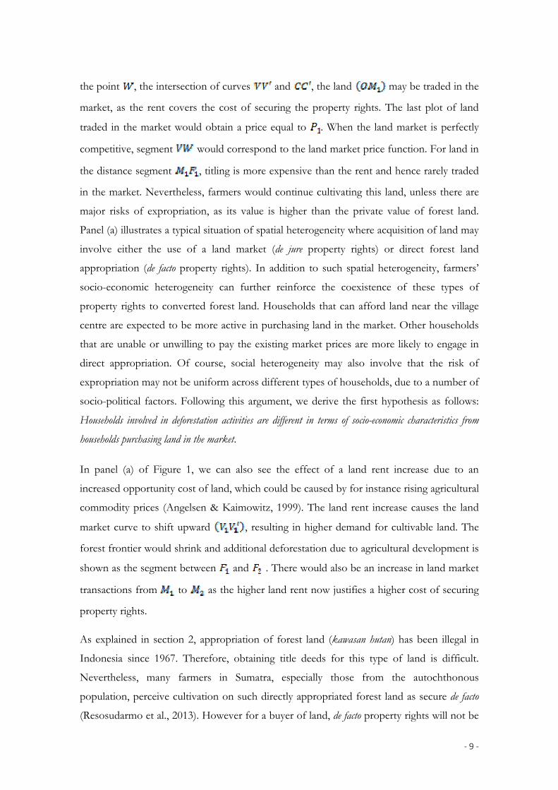
Figure 1 provides a stylized framework illustrating decision-making by the members of a
heterogeneous farming community regarding different pathways of land acquisition. We
start by discussing panel (a). The horizontal axis shows the distance of a plot of land from
the village center of economic activity at . We assume that land is homogeneous except
for the distance. The cost involved in reaching the plot or transporting the harvest to the
market increases with distance and is assumed to limit the further expansion of the
agricultural frontier. The vertical axis shows the shadow price of land, which captures the
economic value of agricultural production and also any non-pecuniary values.1 The cost of
obtaining and maintaining secure land property rights is also shown on the vertical axis.
Building on a spatially-explicit von Thünen model (Angelsen, 2010), we assume that land is
allocated to the use that generates the highest land rent, and thus the value of agricultural
land declines with increasing distance, due to increased cost of marketing the produce from
further away (curve ). Likewise, the private value of forest land, e.g. due to its timber
and non-timber products that could be sold in a given market, is also a negative function of
distance to the village centre due to transportation costs as depicted by curve
(Angelsen, 2010). As long as the marginal commercial value of agricultural land is greater
than that of forest ( ), the land will be under agricultural production; beyond that point
the land will be under forest. However, not all the land appropriated from forest is traded
in the market. This is because there are transaction costs, for instance, associated with
documenting that the land belongs to the seller for creating effective market demand.
<< Figure 1 here >>
The transaction cost associated with obtaining and maintaining secure private property
rights to converted land is shown as , which is assumed to be a positive and increasing
function of distance, as it not only includes administrative components, such as applying
for a title, but also other physical measures, such as fencing and controlling the plot. Up to 1 The shadow price of land is determined not only by the marginal revenue function of
agricultural production, but also by the households' managerial ability and constraints in labour, credit, and land markets (Deininger & Feder, 2001).
‐ 9 ‐
the point , the intersection of curves and , the land may be traded in the
market, as the rent covers the cost of securing the property rights. The last plot of land
traded in the market would obtain a price equal to . When the land market is perfectly
competitive, segment would correspond to the land market price function. For land in
the distance segment , titling is more expensive than the rent and hence rarely traded
in the market. Nevertheless, farmers would continue cultivating this land, unless there are
major risks of expropriation, as its value is higher than the private value of forest land.
Panel (a) illustrates a typical situation of spatial heterogeneity where acquisition of land may
involve either the use of a land market (de jure property rights) or direct forest land
appropriation (de facto property rights). In addition to such spatial heterogeneity, farmers’
socio-economic heterogeneity can further reinforce the coexistence of these types of
property rights to converted forest land. Households that can afford land near the village
centre are expected to be more active in purchasing land in the market. Other households
that are unable or unwilling to pay the existing market prices are more likely to engage in
direct appropriation. Of course, social heterogeneity may also involve that the risk of
expropriation may not be uniform across different types of households, due to a number of
socio-political factors. Following this argument, we derive the first hypothesis as follows:
Households involved in deforestation activities are different in terms of socio-economic characteristics from
households purchasing land in the market.
In panel (a) of Figure 1, we can also see the effect of a land rent increase due to an
increased opportunity cost of land, which could be caused by for instance rising agricultural
commodity prices (Angelsen & Kaimowitz, 1999). The land rent increase causes the land
market curve to shift upward , resulting in higher demand for cultivable land. The
forest frontier would shrink and additional deforestation due to agricultural development is
shown as the segment between and . There would also be an increase in land market
transactions from to as the higher land rent now justifies a higher cost of securing
property rights.
As explained in section 2, appropriation of forest land (kawasan hutan) has been illegal in
Indonesia since 1967. Therefore, obtaining title deeds for this type of land is difficult.
Nevertheless, many farmers in Sumatra, especially those from the autochthonous
population, perceive cultivation on such directly appropriated forest land as secure de facto
(Resosudarmo et al., 2013). However for a buyer of land, de facto property rights will not be
‐ 10 ‐
sufficient. Especially migrants from outside the local community require de jure property
rights before making a purchase decision. Hence, due to the lack of de jure tenure security,
converted forest land will be in low demand especially by migrants in the land market for
this type of land. The existing literature on tenure security and deforestation has rarely
addressed issues of different types of tenure security (Robinson, Holland, & Naughton-
Treves, 2014).
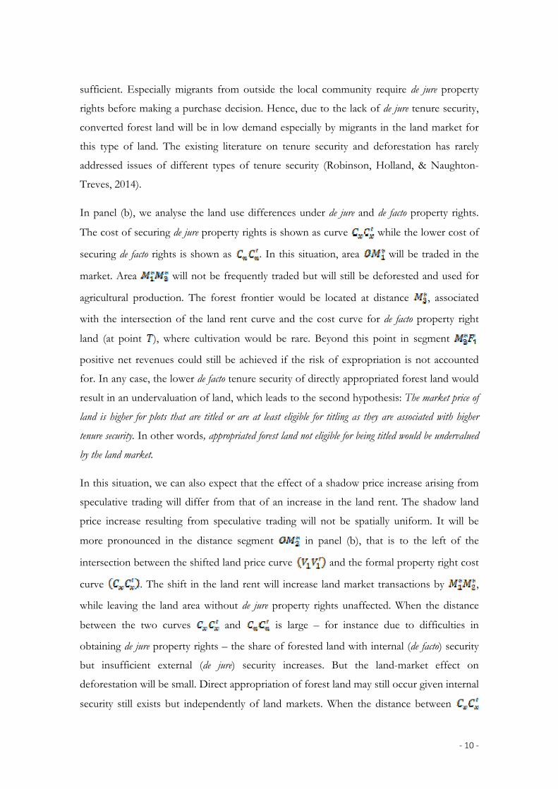
In panel (b), we analyse the land use differences under de jure and de facto property rights.
The cost of securing de jure property rights is shown as curve while the lower cost of
securing de facto rights is shown as . In this situation, area will be traded in the
market. Area will not be frequently traded but will still be deforested and used for
agricultural production. The forest frontier would be located at distance , associated
with the intersection of the land rent curve and the cost curve for de facto property right
land (at point ), where cultivation would be rare. Beyond this point in segment
positive net revenues could still be achieved if the risk of expropriation is not accounted
for. In any case, the lower de facto tenure security of directly appropriated forest land would
result in an undervaluation of land, which leads to the second hypothesis: The market price of
land is higher for plots that are titled or are at least eligible for titling as they are associated with higher
tenure security. In other words, appropriated forest land not eligible for being titled would be undervalued
by the land market.
In this situation, we can also expect that the effect of a shadow price increase arising from
speculative trading will differ from that of an increase in the land rent. The shadow land
price increase resulting from speculative trading will not be spatially uniform. It will be
more pronounced in the distance segment in panel (b), that is to the left of the
intersection between the shifted land price curve and the formal property right cost
curve . The shift in the land rent will increase land market transactions by ,
while leaving the land area without de jure property rights unaffected. When the distance
between the two curves and is large – for instance due to difficulties in
obtaining de jure property rights – the share of forested land with internal (de facto) security
but insufficient external (de jure) security increases. But the land-market effect on
deforestation will be small. Direct appropriation of forest land may still occur given internal
security still exists but independently of land markets. When the distance between
‐ 11 ‐
and is small – that is, when the relative difference between acquiring external vs.
internal property rights is small – speculative land market trading will likely lead to an
increase in deforestation. Thus, connecting the first two hypotheses, we derive a third
hypothesis goes as follows: Given farmer heterogeneity and weak external (de jure) tenure security for
directly appropriated forest land, land markets are not associated with increased rates of deforestation.
Recent studies in Indonesia and elsewhere showed that appropriation of forest land is
particularly rapid in regions where the economic returns to agriculture are high (Ferretti-
Gallon & Busch, 2014; Lee et al., 2014; Richards, Walker, & Arima, 2014). Since changes in
the returns to agriculture and other related factors also affect land property rights, rates of
deforestation, and land market developments simultaneously, empirical analysis of causal
relationships tend to be plagued by issues of endogeneity. We acknowledge possible biases
in impact assessment and therefore do not claim to establish clear causal relationships in
our empirical analysis. We rather look at associations between relevant variables to test the
hypothesis derived from the conceptual framework.
4. Analysis of land acquisition
4.1. Household and village level data
The empirical analysis builds on a survey of farm households in Jambi Province, Sumatra,
which was carried out in the second-half of 2012. In total, 701 farm households in five
regencies were sampled.2 These five regencies – Sarolangun, Bungo, Tebo, Batanghari, and
Muaro Jambi – were selected purposively; they comprise most of the lowland regions in
Jambi where deforestation and related land use changes were particularly rapid during
recent decades. Four districts per regency and two villages per district were then selected
randomly, resulting in a total of 40 villages in 20 districts. In addition, five villages in two of
the regencies where complementary biophysical research activities were carried out were
purposively selected. A map with the location of villages surveyed is shown in Figure 2. In
each village, complete lists of households were compiled from which we sampled
randomly. As villages differ significantly in size, ranging from about 100 to more than 2000
households, the number of households sampled per village was adjusted to the population
size. Details of the villages and the number of households sampled per village are provided
2 Regencies are second-level administrative subdivisions in Indonesia, below the provinces
and above the districts (Turner et al., 2003).

‐ 12 ‐
by Faust et al. (2013; pp. 29-32). We include household observations from all 45 villages. In
the empirical models, we use a dummy for observations from purposively selected villages
to test and control for possible differences.
<< Figure 2 here >>
Using a structured and pre-tested questionnaire, face-to-face interviews with farm
household heads were conducted in the local language (Bahasa Indonesia) by a team of 12
enumerators. The interviews covered details of current agricultural and non-agricultural
economic activities, as well as more general socioeconomic characteristics of the
households. Historical data on land acquisition and land use changes were also collected
through a recall for all plots that farmers owned and managed. Since land acquisitions are
important non-frequent events for the farm household, survey respondents did not find it
difficult to recall details such as land prices and land use changes, even when referring to
periods in the more distant past, like in 1950s and 1960s. Data quality was further ensured
through multiple cross-checks during and after the principal surveying phase, including
subsequent telephone calls to farmers. Concerning land area, plots were visited and
measurements were taken of about one-third of the plots to validate the acreages reported
by farmers (see: Faust et al., 2013).
Beside the farm household survey, a village-level survey was carried out in the sample
villages in 2012 by another team of researchers. The village survey was conducted with
small groups of key informants, such as the village head, the village secretary, sub-village
(dusun) leaders, and elderly villagers, among others (Gatto, Wollni, & Qaim, 2015). The
survey focused on land use changes and related institutional aspects at the village level
covering three points in time over two decades, namely 1992, 2002 and 2012. In many of
the villages, historical data were well-documented in archives kept by the village secretary.
The reported land use patterns and changes at the village level are consistent with the
remote sensing (Landsat) data (Melati et al., 2015).
4.2. Descriptive statistics
In the household survey, detailed information was collected on the type of land acquisition
and land use changes for all plots owned and managed by the households. In case of land
use change following ownership change, the original land use was also recorded. We focus
on the plots with plantation crops, mainly oil palm, rubber, and jungle rubber (a rubber

‐ 13 ‐
agroforestry system that has become rare more recently in Jambi due to land use
intensification). These plantation crops account for 97 percent of the total cultivated area
owned by the sample households.
Based on the survey data, we find four main pathways of land acquisition by farm
households in Jambi (Table 1). Of the 1,259 plantation plots in our sample, 44 percent
were purchased in the land market, 19 percent were acquired through direct appropriation
of state forest land (kawasan hutan), 9 percent were allocated as part of government
programs, especially through the transmigration program, and 27 percent were obtained
through inheritance or inter-vivo transfers. Table 1 also shows that majority of the plots
traded in the market was under cultivation with plantation or annual crops (identified as
‘crop land’) or finished timber extraction (‘bush and grass land’) at the time of acquisition
through the land market. Bush and grass lands were often referred locally to as fallow land
or ‘sleeping land’ (lahan tidur). Plots acquired through direct appropriation of forest land
were significantly bigger than plots acquired through other pathways. However, direct
appropriation is not the only pathway that contributes to deforestation. As can be seen in
Table 1, clearing forest also occurred on some of the plots that were transacted in the land
market (13 percent of all market transactions) or obtained through inheritance and inter-
vivo transfers (10 percent). A few of the plots in our sample were already acquired by
farmers in the late 1950s and 1960s. Yet, 86 percent of the plots were acquired only after
1990.
<< Table 1 here >>
Figure 3 shows that direct appropriation of forest land has been an important pathway of
land acquisition for cultivation in Jambi over the last decades (1972-2012). Nevertheless,
land market transactions gained in importance over time. Of all land acquired by farmers
before 1992, only 27 percent were purchased in the market, while 46 percent were acquired
through direct appropriation. These shares were reversed in the subsequent decades.
However, this does not imply that aggregated deforestation activities by the sampled
households declined over time (Figure 4). In other words, although the relative importance
of direct appropriation has come down as a pathway of land access, deforestation by
smallholder farmers is still prevalent in Jambi. Similar observation is also made by Gatto,
Wollni, & Qaim (2015). Nevertheless, to what extent deforestation is a function of the land
market development is an empirical question.
‐ 14 ‐
<< Figure 3 here >>
<< Figure 4 here >>
Figure 5 shows the type of land use on plots traded in the market at the time of ownership
change. Notable changes can be observed over time. While before 1992, almost 30 percent
of the traded land was covered with forest, the share of forested land was less than 10
percent in the 2003-2012 period. In contrast, the share of crop land that was traded in the
market increased over time. The increased prominence of land markets as a pathway to
acquire cultivable land, together with the fact that the share of forest land being traded is
diminishing, may prompt one to think that land markets play a key role in determining the
rate of deforestation in the study area.
<< Figure 5 here >>
Table 6 in the Appendix further compares plots purchased in the market with plots
acquired through other pathways, also differentiating between autochthonous and
transmigrant villages. The majority of the buyers in land markets are migrants.3 Plots traded
in the market are more likely to have a sporadic title. The information whether a plot has a
title is only available for 2012. Hence we do not know whether a plot already had a title at
the time of ownership change.
4.3. Econometric analysis
Testing of hypothesis 1: Households involved in deforestation activities are different in terms of socio-
economic characteristics from households purchasing land in the market.
To identify the determinants of land purchase and deforestation, we employ probit models.
There are two dummy variables: if farmers purchased land in the market (0
otherwise), and if farmers are involved in deforestation activities (0 otherwise).
Both pathways are not mutually exclusive, that is, one and the same household may
possibly have acquired land through different pathways. Also, as was mentioned previously,
deforestation can occur even on land that was purchased in the market. Hence, we cannot
3 We do not have data on the characteristics of land sellers.
‐ 15 ‐
estimate the two equations separately. To account for possible error-term correlation we
estimate a seemingly unrelated bivariate probit (SUBP) model:
where subscript i stands for the farm household as the unit of observation. The error
terms, and , are assumed to be identically distributed as bivariate normal with zero
mean, unit variance, and correlation coefficient . The hypothesis of exogeneity of
is tested as against using a likelihood-ratio (LR) test
(Monfardini & Radice, 2008). This test has the additional advantage that identification does
not require the set of controls to differ across equations (Wilde, 2000). The sign and
magnitude of indicates how strongly the unobserved factors determine market purchase
and deforestation simultaneously.
is a vector of household socioeconomic characteristics that may influence land
acquisition decisions. It includes variables such as ethnicity, migration background, and
education of the household head as well as locational factors. Significant differences in the
estimates associated with these socio-demographic variables between the two equations
would imply non-rejection of the first hypothesis.
Testing of hypothesis 2: The market price of land is higher for plots that are titled or are at least eligible for
titling as they are associated with higher tenure security.
This hypothesis is about prices and values of land with different degrees of external (de jure)
tenure security. To test whether directly appropriated land is undervalued by the land
market, as hypothesized, we compute net present values (NPVs) of rubber and oil palm
plantations and compare them with the land market price for the respective plantation
types, adjusted for inflation.4 For the NPV calculations, we do not distinguish between
4 The NPV calculations are based on input-output data for 363 oil palm and 882 rubber
plots referring to 2012. The cost of family labor was not included. In order to assess the cash flows occurring at different times during a plantation cycle, we exploited the fact that the plantations in our sample were established at different points in time and thus had different ages. Hence, we calculate average NPVs for oil palm and rubber plantations in the sample, not NPVs for individual plots.
‐ 16 ‐
plantations on traded vis-à-vis directly appropriated land because systematic differences are
not expected in terms of productivity. NPVs that are significantly above land market prices
would support the land undervaluation hypothesis at least for some of the plots. In such a
scenario, speculative land market trading would be unlikely, as a rational farmer would find
cultivation of plantation crops financially more attractive than selling the plot in land
market. To further differentiate between different types of plots with respect to tenure
security, we also compare land market prices for plots with systematic titles and without
any titles.
Additionally, we estimate hedonic regression models to get further insights into what
determines prices of land in the market. Hedonic price modelling is a revealed preference
method for non-market valuation of environmental and natural resources (Ma & Swinton,
2011). This analysis can only be confined to those plots that were traded in the market. The
market price is regressed on a time variable and a vector of plot characteristics, such as plot
size, location, and previous land use at the time of the transaction. Furthermore, we include
international market prices of rubber and palm oil as explanatory variables, as these are
expected to influence the land rent, which in turn is assumed to be a key determinant of the
market value of land.5 Average export prices of palm oil and rubber for the three years
prior to the land transaction are used as proxies for the average land rent. Unfortunately,
whether or not the plot has a title cannot be included; as mentioned previously, this
information is only available for 2012, not for the time of the market transaction of the
given plot of land.
In this hedonic price model, it is difficult to make a priori assumptions about the functional
form. We therefore apply a power transformation to the data as proposed by Box & Cox
(1964). The Box-Cox transformation allows several popular functional forms – such as
linear, log-linear, and inverse – and has received significant attention in the empirical
literature, including for instance the studies on land valuation by Snyder et al. (2007) and
Standiford & Scott (2008).
5 The prices that local farmers receive for their harvest are different from international
market prices, due to transaction and processing costs and sometimes also exploitation of market power by local traders and companies. However, even though market power can lead to asymmetric vertical price transmission, prices received by farmers are strongly correlated with international market prices (Kopp et al., 2014).
‐ 17 ‐
Testing of hypothesis 3: Given farmer heterogeneity and weak external (de jure) tenure security for directly
appropriated forest land, land markets are not associated with increased rates of deforestation.
Testing of the first and second hypotheses gives us important indications whether or not
land markets increase the rate of deforestation. In the third hypothesis, we test this
relationship more explicitly using two different approaches. To begin with, we use and
extend the SUBP models already explained in connection with hypothesis 1. Examining the
effect of village characteristics, such as the presence of forest in the past and over time,
helps establish a possible association between land market transactions and deforestation
rates. Second, we analyse the correlation between land market developments and
deforestation at the village level. Deforestation is measured in terms of net permanent
change in forest land use during the time period 1993-2002. Land market development is
measured by the share of market transactions in all land acquisitions by the sampled
households in their village during the same period. In addition, we look at land market
developments in the subsequent decade (2003-2012) to analyse whether deforestation, in
reverse, fuel market transactions with a time lag. The estimation of insignificant correlation
coefficients would denote that the third hypothesis cannot be rejected.
5. Results and discussion
5.1. Land market participation and deforestation
To analyse whether farm households that are involved in deforestation activities are
systematically different from those who purchase land in the market (hypothesis 1), we use
seemingly unrelated bivariate probit (SUBP) models, as explained above. The estimation
results are shown in Table 2. Model (1) includes all observations of farm-households that
owned land and cultivated rubber and/or oil palm. The time variable (time of starting
plantation by household) confirms that land market transactions increased in importance
more recently, while the probability of deforestation activities declined. However, models
(2) and (3), which only include observations for particular time periods, suggest that rates
of deforestation did not decrease further after 1992. Several of the other explanatory
variables also affect farmers’ land market purchase and deforestation decisions in opposite
directions. Better educated farmers are more likely to purchase land and at the same time
less likely to deforest. Education can also be seen as a proxy for human capital, hence there
seems to be a positive association between household level human capital and land market
participation.

‐ 18 ‐
<< Table 2 here >>
The model results in Table 2 also suggest that aspects related to migration and ethnicity
play an important role for households’ land acquisition decisions. Households who
migrated to a transmigrant village are more likely to acquire land from the market and less
likely to acquire land through direct appropriation of forest land, and thus associated with
increased rate of deforestation. As transmigrant villages were artificially created through
government initiative mainly during the 1980s and 1990s, community structures are less
traditional and customary law (adat) does not apply to the same extent as in autochthonous
villages. Hence, directly appropriated land may lack even internal tenure security in
transmigrant villages. Another reason why land markets are more dominant in transmigrant
villages is that a large share of the transmigrant households has formal systematic titles for
their land. As discussed in section 3, this provides external tenure security and thus
facilitates land market transactions. The estimation coefficients for Javanese and Sundanese
ethnicity also corroborate this.
Both Javanese and Sundanese ethnicities originate from Java; many of these households
migrated to Sumatra as participants in the government’s transmigration program, while
many migrated independently. These ethnicities are less involved in deforestation. In other
words, the autochthonous Melayu population that contributes the majority of non-
Javanese/Sundanese households is more likely to acquire land through deforestation. This
should not be taken as evidence of anti-conservationist attitudes of the autochthonous
population. Rather, it is likely that the autochthonous people perceive forest land
appropriation as a legitimate strategy for securing de facto (internal) property rights, as also
has been observed elsewhere (Mendelsohn, 1994; Angelsen & Kaimowitz, 1999; Angelsen,
2001; Araujo et al., 2009). In the past, autochthonous villages in Jambi were often targeted
by public and private companies for logging and establishing oil palm plantations (Gatto,
Wollni, & Qaim, 2015). Since these companies mainly target forest land for establishing
plantation, the risk of potential expropriation could be reduced by farm households
through clearing the forest and establishing plantation crops themselves beforehand.
Complementing the household-level analysis, we also estimate additional probit models at
the plot level, explaining the factors that influence whether a plot was purchased in the
market or acquired through direct appropriation of kawasan hutan. These models are
different from household-level models presented in Table 2 also because the term
‐ 19 ‐
‘deforestation’ used in the household-level analysis is somewhat broader; deforestation
involves the clearing of kawasan hutan as well as privately-owned forests. We exclude plots
inherited or obtained through inter-vivo transfers, and do not address deforestation
directly. These probit models are shown in Table 7 in the Appendix. The additional
estimates from this table confirm the results from Table 2. Furthermore, we find that plots
located further away from the household residence (which is mostly near the village centre)
are less likely to be traded in the market as discussed in the conceptual framework in
section 3 (Figure 1).
Based on these analyses, we conclude that households involved in deforestation are
different from households purchasing land in the market in terms of various social
characteristics. This confirms our first hypothesis. Furthermore, we find indications that
the plots that are traded in the market also differ from plots developed through
appropriation, especially with respect to their location.
5.2. Analysis of land prices
The second hypothesis states that directly appropriated forest land that lacks external (de
jure) tenure security is undervalued in the market. In other words, land price in the
prevailing market scenario is hypothesized to be lower than the potential rent that farmers
can obtain by cultivating the directly appropriated forest land. Table 3 compares the land
prices reported by sampled farmers with the NPVs for rubber and oil palm plantations.
Indeed, the mean land prices are significantly lower than the NPVs when reasonable
discount rates are used. The picture only turns at discount rates above 13 percent and 18
percent for oil palm and rubber plantations, respectively. These values are high even by the
Indonesian standards as interest rates in the formal credit market are around 7 percent per
annum. Keeping the land for own cultivation instead of selling hence seems to be
financially rational for the average land-owner in our sample.
<< Table 3 here >>
The most plausible explanation for the undervaluation of land in the market is the weak
property rights protection. At the time of the survey in 2012, only about 50 percent of all
plots owned by the sampled households had some form of formal land title. Figure 6
shows that this share is higher for plots that were traded in the market and significantly
‐ 20 ‐
lower for plots that were acquired through illegal appropriation of forest land (appropriated
after 1970s), which supports our hypothesis. Interestingly however, some of the farmers
succeeded in obtaining a formal title – mostly sporadic titles – for directly appropriated
forest land anyway. As such land is actually not eligible for titling, this seeming contraction
may be due to the existing legal ambiguities and rent-seeking in the Indonesian
bureaucracy.6
<< Figure 6 here >>
Table 4 looks at the role of tenure security from a different perspective. Market prices of
land are compared between land with systematic title and without any formal title.7 The
comparison in Table 4 confirms that plots with stronger tenure security are priced highly
across the different land use systems. Similar observations were also made in other
countries (Feder & Nishio, 1999; Deininger & Chamorro, 2004). The de facto property right
protection under customary law might provide sufficient internal tenure security for some
households. However, without de jure property rights and external tenure security, the land
seems to remain undervalued in the market, thus confirming our second hypothesis.8 While
6 While the Forestry Law of 1967 designates around 70 percent of the national land area as
state forest land (kawasan hutan) (Article 1.3), there exists another stipulation (Article 14) that this land needs to be gazetted to technically become state land. Hence, the designation of forest land can be regarded as a preparatory step, which needs to be followed by boundary demarcation, particularly for areas bordering privately owned land. With less than 10 percent of the state land being gazetted so far (Indrarto et al., 2012), multiple legal interpretations are possible. Resulting opportunities are seized by some of the peasant households. Hence, legal ambiguity seems to contribute to deforestation in the study area.
7 We do not know whether the title was obtained before or after the market transaction. Yet buyers and sellers are assumed to have a fairly good understanding of the general eligibility of a plot for titling, so that they can assess the tenure security also when a title was not yet issued at the time of the transaction.
8 Since we do not have data on the timing of land titling vis-à-vis land transaction, there arises a valid question: does higher market value of land lead to titling, or does titling lead to higher market value for a plot transacted in the market? It is reasonable to assume that titling (or general eligibility of a plot for titling) leads to higher price of land in the market (and not the other way round), due to two major reasons. First, the market price of land with systematic title is found to be significantly high (Table 4), while obtaining a systematic title – just because the land was purchased at a higher price – is less plausible. Systematic titling requires a number of supporting documents to verify that the land was not appropriated from the state kawasan hutan. Second reason is the high internal tenure security of agricultural land. Within the village community, there exists a strong conviction for the peasant households that the de facto tenure (without title deeds) is secure, and farmers need not register their land only to make it more secure. These two
‐ 21 ‐
the de jure property rights regulations do not prevent forest land appropriation in Jambi,
they at least contribute to discouraging rural households from clearing forest for
speculative trading in land markets.
<< Table 4 here >>
Results from the hedonic model, which we use to analyse other factors that may have
influenced land market prices, are shown in Table 5. Two different models are shown.
Model (1) includes a time variable, while model (2) includes commodity export prices and
price ratios observed in particular years. As export prices are closely correlated with time,
both sets of variables could not be included in the same model in order to avoid strong
multicollinearity. The estimates for the time trend and its square term in model (1) show
that land market prices first decreased and then increased during 1992-2012 period. The
turning point after which land prices increased was in 2002, reflecting international
commodity price developments. Model (2) confirms that export prices of palm oil and
rubber have affected local land prices significantly. Another factor that influences land
prices in both models is the size of the plot, in spite of the fact that prices are expressed
per ha. Larger plots are traded at lower prices per ha, probably due to transaction costs that
do not increase proportional to plot size. Unsurprisingly, the type of land use also matters,
with oil palm plots fetching the highest prices. Finally, we observe that land prices are
higher in transmigrant than in autochthonous villages. This may be due to various reasons,
including better infrastructure and stronger land tenure security in transmigrant villages.
<< Table 5 here >>
5.3. Land market development and rate of deforestation
We now test the third hypothesis, looking explicitly at the association between land market
activities and rate of deforestation. We start this analysis by using the SUBP models shown
in Table 2 and focusing on the village-level explanatory variables that were not discussed
above. The results in model (2) of Table 2 show that the extent of presence of forest in the
village in 1992 was associated with a higher probability of deforestation. Furthermore, the
results in model (3) reveal that the extent of deforestation in 1993-2002 period was also
unique features of land markets denote that it is titling that causes higher land market value and that the chances of reverse causality are small.
‐ 22 ‐
associated with a higher probability of households deforesting in the subsequent decade.
Building on the forest transition theory (Mather & Needle, 1998), villages in Jambi are still
in the ‘land use transition’ phase. During this phase, forest land is still being converted to
agricultural land (Barbier, Burgess, & Grainger, 2010). Higher deforestation rates are
observed in villages with large tracts of forest land, as would be expected.
However, the results in Table 2 also show that neither the presence of forest nor past
deforestation rates in the village are significantly associated with households’ decisions to
purchase land in the market, suggesting that the deforested land does not end up in the
land markets. This inference is also supported by the fact that the error term correlation is
insignificant in two of the three models in Table 2. In model (3), we find a significant error
term correlation, but with a negative sign. Hence, this implies that there is no positive
association between land market development and deforestation.
In Figure 7, we take a village-level perspective and show deforestation rates against land
market developments in the same and in the subsequent decades. The resulting correlation
coefficients are small and statistically insignificant. The sample of villages is limited, so
these insignificant correlation coefficients alone should not be over-interpreted. But
together with the other results it seems justified not to reject hypothesis 3 and indicate that
land markets in Jambi have not had a significant effect on deforestation rates. Land
markets are found neither promote nor deter deforestation in a meaningful way according
to the data.
<< Figure 7 here >>
The analysis suggests that the major threat for forest land in Jambi lies outside the purview
of land markets. The direct appropriation of state forest land, instigated by a booming
export sector and facilitated by legal ambiguity and high internal tenure security for
appropriated land, are more relevant factors behind deforestation. These results are
consistent with Wheeler et al. (2013) and Resosudarmo et al. (2013). Against this backdrop,
ongoing policy initiatives aimed at providing land titles to rural households alone may not
suffice to reduce deforestation in Sumatra.
‐ 23 ‐
5. Conclusions
In this study, we have analysed the relationship between evolving land markets and
deforestation in Sumatra, Indonesia. Using survey data from smallholder farm households
in Jambi Province, the determinants and implications of land market transactions over a
period of two decades are examined. The focus was on explaining farmers’ decisions
concerning the acquisition of land either through the market or through direct (generally
illegal) appropriation of forest land. The data suggest that deforestation activities of
smallholders are not driven by land market developments. At the same time, land market
developments have so far also not contributed significantly to reducing deforestation.
Households involved in land market transactions are generally different from households
involved in deforestation through direct appropriation of forest land. Our model reveals
that better educated farmers are more likely to purchase land. Moreover, transmigrants
from Java are more often involved in land market transactions than the autochthonous
people for whom acquiring land through direct appropriation is more common. The latter
observation is partly due to differences between transmigrant and autochthonous villages in
terms of the prevalence and scope of de jure property rights under state law and de facto
property rights under customary law.
The data also suggest that the sense of external tenure security is low for land that is not
titled and not eligible for titling, leading to the undervaluation of directly appropriated
forest land. It is profitable for farmers to clear forest land for rubber and/or oil palm
cultivation, but because of the low external tenure security it is less lucrative to sell this land
in the market. This situation has so far prevented the emergence of speculative forest
clearing and trading activities. Hence, the land markets coexist with forest land
appropriation without immediate interlinkages. Of course, this situation might change with
altered conditions. For instance, easier access to de jure property rights over appropriated
forest land would likely spur speculative land market trading and deforestation.
However, the impacts of land property rights on deforestation are multi-faceted. While
weak property rights may help prevent speculative land market trading, they do not prevent
forest land appropriation by smallholders. Weak de jure property protection also provides
favourable conditions for logging and plantation companies to appropriate the forest land
in autochthonous villages. We argue that autochthonous communities in Sumatra have
been more actively involved in forest land conversion themselves compared to a
‐ 24 ‐
counterfactual associated with a stronger legal property protection regime. The empirical
evidence for such strategic deforestation by smallholders is limited in the literature, with a
possible exception of Miyamoto (2006), who reported that proximity to transmigration
projects in Sumatra influences the land tenure security of the autochthonous people and
prompt them to increase the rate of deforestation in the medium-term. In this paper, we
have not explicitly analysed the interaction between the activities by large logging and
mining companies (as well as other commodity companies involved in oil palm and rubber
production) and smallholders’ strategic deforestation decisions, and remains a relevant
topic for future research.
Providing suitable property right protection for agricultural landholdings, defining
boundaries for private, community, and state lands, and simultaneously conserving forest
resources are not easy tasks for land-governing agencies in Indonesia. While around 70
percent of Indonesia’s territory is legally declared state forest land, this land is mostly
inhabited by local people who are claiming customary land rights. Legal ambiguities seem
to contribute to opportunistic behavior by some and to a race-to-the-bottom between
large-scale companies and small-scale farmers trying to secure de facto property rights. The
Indonesian government has ongoing programs to provide formal land titles for privately
owned land. However, in addition it will be crucial to clearly demarcate the forest land and
establish effective monitoring systems, possibly involving community institutions. Further
options of sustainable forest management should be explored and defined as forms of
productive use of land in Indonesian law. Such initiatives could possibly contribute to
reducing deforestation at low administrative costs. This is especially relevant since the
opportunity cost of forest land is likely to increase due to rising land rents under the
increased global demand for oil palm and rubber commodities.
References
Alston, L. J., Libecap, G.D., & Schneider, R. (1996). The determinants and impact of
property rights: Land titles on the Brazilian Frontier. The Journal of Law, Economics, and
Organization, 12(1), 25-61.
Angelsen, A. (2001). Playing games in the forest: State-local conflicts of land
appropriation. Land Economics, 77(2), 285-299.
‐ 25 ‐
Angelsen A. (2010). Policies for reduced deforestation and their impact on agricultural
production. Proceedings of the National Academy of Sciences USA, 107(46), 19639–19644.
Angelsen, A., & Kaimowitz, D. (1999). Rethinking the causes of deforestation: Lessons
from economic models. World Bank Research Observer, 14(1), 73-98.
Araujo, C., Bonjean, C. A., Combes, J-L., Motel, C. P., & Reis, E. J. (2009). Property rights
and deforestation in the Brazilian Amazon. Ecological Economics, 68(8), 2461-68.
Barbier, E. B. (2001). The economics of tropical deforestation and land use: An
introduction to the special issue. Land Economics, 77(2), 155-171.
Barbier, E. B., Burgess, J. C., & Grainger, A. (2010). The forest transition: Towards a more
comprehensive theoretical framework. Land Use Policy, 27(2), 98-107.
Barraclough, S. L. (2013). Agricultural expansion and tropical deforestation: International trade,
poverty and land use. New York: Earthscan.
Bhattarai, M., & Hammig, M. (2001). Institutions and the environmental Kuznets curve for
deforestation: A cross-country analysis for Latin America, Africa and Asia. World
Development, 29(6), 995-1010.
Boserup, E. (1965). The conditions of agricultural growth: The economics of agrarian change under
population pressure. London: Earthscan Publication Limited.
Box, G. E., & Cox, D. R. (1964). An analysis of transformations. Journal of the Royal
Statistical Society Series B, 26(2), 211-252.
Clark, J.S., Fulton, M., & Scott, J.T. Jr. (1993). The inconsistency of land values, land rents
and capitalization formulas. American Journal of Agricultural Economics, 75, 147-155.
Deininger, K. & Feder, G. (2001). Land institutions and land markets. In Gardner, B. &
Rausser, G. (ed.), Handbook of Agricultural Economics (Vol. 1). Amsterdam: Elsevier, pp.
288-331.
Deininger, K., Zegarra, E., & Lavadenz, I. (2003). Determinants and impacts of rural land
market activity: Evidence from Nicaragua. World Development, 31(8), 1385-1404.
Deininger, K., & Chamorro, J. S. (2004). Investment and equity effects of land
regularization: The case of Nicaragua. Agricultural Economics, 30(2), 101-116.
Deininger, K., & Jin, S. (2008). Land sales and rental markets in transition: Evidence from
rural Vietnam. Oxford Bulletin of Economics and Statistics, 70(1), 67-101.
Deininger, K., Jin, S., & Nagarajan, H.K. (2009). Determinants and consequences of land
sales market participation: Panel evidence from India. World Development, 37(2), 410-421.
‐ 26 ‐
de Janvry, A., & Sadoulet, E. (2001). Access to land and land policy reforms. Policy Brief
No. 3, Helsinki, Finland: The United Nations University World Institute for
Development Economics Research.
Demsetz, H. (1967). Toward a theory of property rights. American Economic Review, 57(2),
347-359.
Euler, M., Schwarze, S., Siregar, H., & Qaim, M. (2015). Oil Palm expansion among
smallholder farmers in Sumatra, Indonesia. EFForTS Discussion Paper 8, Goettingen,
Germany: University of Goettingen.
FAO. (2010). Global forest resources assessment 2010. Forestry Paper 140, Rome, Italy:
Food and Agriculture Organization of the United Nations, p. 378.
Feder, G., & Nishio, A. (1999). The benefits of land registration and titling: Economic and
social perspectives. Land Use Policy, 15(1), 25-43.
Ferretti-Gallon, K., & Busch, J. (2014). What drives deforestation and what stops it? A
meta-analysis of spatially explicit econometric studies. Working Paper 361. Washington,
DC: Center for Global Development.
Faust, H., Schwarze, S., Beckert, B., Brümmer, B., Dittrich, C., Euler, M., Gatto, M.,
Hauser-Schäublin, B., Hein, J., Ibanez, M., Klasen, S., Kopp, T., Holtkamp, A. M.,
Krishna, V., Kunz, Y., Lay, J., Mußhoff, O., Qaim, M., Steinebach, S., Vorlaufer, M., &
Wollni, M. (2013). Assessment of socio-economic functions of tropical lowland
transformation systems in Indonesia: Sampling framework and methodological
approach. EFForTS Discussion Paper 1, Goettingen, Germany: University of
Goettingen.
Fitzpatrick, D. (2006). Evolution and chaos in property rights systems: The third world
tragedy of contested access. Yale Law Journal, 115(5), 996-1048.
Fitzpatrick, D. (1997). Disputes and pluralism in modern Indonesian land law. Yale Journal
of International Law, 22(1), 170-212.
Gatto, M., Wollni, M., & Qaim, M. (2015). Oil palm boom and land use dynamics in
Indonesia: the role of policies and socioeconomic factors. Land Use Policy, 46, 292-303.
Geist, H. J., & Lambin, E. F. (2002). Proximate causes and underlying driving forces of
tropical deforestation. BioScience, 52(2), 143-150.
Gibbs, H.K., Ruesch, A.S. Achard, F., Clayton, M.K., Holmgren, P., Ramankutty, N., &
Foley, J.A. (2010). Tropical forests were the primary sources of new agricultural land in
the 1980s and 1990s. Proceedings of the National Academy of Sciences USA, 107(38), 16732 –
16737.
‐ 27 ‐
Godoy, R., Kirby, K., & Wilkie, D. (2001). Tenure security, private time preference, and
use of natural resources among lowland Bolivian Amerindians. Ecological Economics, 38(1),
105-118.
Haverfield, R. (1999). ‘Hak ulayat’ and the state: Land reform in Indonesia. In T. Lindsey
(ed.), Indonesia: Law and society. Sydney: The Federation Press.
Hertel, T. W., Ramankutty, N., & Baldos, U. L. C. (2014). Global market integration
increases likelihood that a future African Green Revolution could increase crop land use
and CO2 emissions. Proceedings of the National Academy of Sciences USA, 111(38), 13799-
13804.
Holden, S.T., Otsuka, K., & Place, F. M. (2009). Understanding land markets: Questions
and hypotheses. In S.T. Holden, K. Otsuka, & F.M. Place (eds.), The emergence of land
markets in Africa. Washington DC: Resources for the Future. pp: 18-56
Indrarto, G. B., Murharjanti, P., Khatarina, J., Pulungan, I., Ivalerina, F., Rahman, J., Prana,
M.N., Resosudarmo, I.A.P., & Muharrom, E. (2012). The context of REDD+ in
Indonesia: drivers, agents and institutions. CIFOR Working Paper 92, Bogor, Indonesia:
Center for International Forestry Research.
Johnson, K. A., & Nelson, K. C. (2004). Common property and conservation: The
potential for effective communal forest management within a national park in
Mexico. Human Ecology, 32(6), 703-733.
Kopp, T. Alamsyah, Z., Fatricia, R.S., & Brümmer, B. (2014). Have Indonesian rubber
processors formed a cartel? Analysis of intertemporal marketing margin manipulation.
EFForTS Discussion Paper Series No. 3, Goettingen, Germany: University of
Goettingen.
Lee, J. S. H., Abood, S., Ghazoul, J., Barus, B., Obidzinski, K., & Koh, L. P. (2014).
Environmental impacts of large‐scale oil palm enterprises exceed that of smallholdings
in Indonesia. Conservation Letters, 7(1): 25-33.
Lindsey, T. (1998). Square pegs and round holes: Fitting modern title into traditional
societies in Indonesia. Pacific Rim Law & Policy Association, 7, 699-719.
Liscow, Z. D. (2013). Do property rights promote investment but cause deforestation?
Quasi-experimental evidence from Nicaragua. Journal of Environmental Economics and
Management, 65, 241-261.
Ma, S., & Swinton, S. M. (2011). Valuation of ecosystem services from rural landscapes
using agricultural land prices. Ecological Economics, 70(9), 1649-1659.
‐ 28 ‐
Margono, B. A., Turubanova, S., Zhuravleva, I., Potapov, P., Tyukavina, A., Baccini, A.,
Goetz, S., & Hansen, M. C. (2012). Mapping and monitoring deforestation and forest
degradation in Sumatra (Indonesia) using Landsat time series data sets from 1990 to
2010. Environmental Research Letters, 7(3), 034010.
Mather, A. S., & Needle, C. L. (1998). The forest transition: a theoretical basis. Area, 117-
124.
McCarthy, J.F. (2000). The changing regime: forest property and Reformasi in Indonesia.
Development and Change, 31, 91-129.
Melati, D. N., Nengah Surati Jaya, I., Pérez-Cruzado, C., Zuhdi, M., Fehrmann, L.,
Magdon, P., & Kleinn, C. (2015). Spatio-temporal analysis on land transformation in a
forested tropical landscape in Jambi Province, Sumatra. EGU General Assembly
Conference Abstracts, 17, 15014.
Mendelsohn, R. (1994). Property rights and tropical deforestation. Oxford Economic Papers,
46, 750–56.
Meyfroidt, P., Lambin, E.F., Erb, K-H., & Hertel, T.W. (2013). Globalization and land use:
distant drivers of land change and geographic displacement of land use. Current Opinion
on Environmental Sustainability, 5, 1-7.
MoF. (2009). Eksekutif data strategis kehutanan 2009. Jakarta: Ministry of Forestry,
Government of Indonesia.
Monfardini, C., & Radice, R. (2008). Testing exogeneity in the bivariate probit model: a
Monte Carlo study. Oxford Bulletin of Economics and Statistics, 70, 271 -282.
Miyamoto, M. (2006). Forest conversion to rubber around Sumatran villages in Indonesia:
Comparing the impacts of road construction, transmigration projects and
population. Forest Policy and Economics, 9(1), 1-12.
Peluso, N. L. (2005). Seeing property in land use: Local territorializations in West
Kalimantan, Indonesia. Geografisk Tidsskrift-Danish Journal of Geography, 105(1), 1-15.
Phelps, J., Carrasco, L.R., Webb, E.L., Koh, L.P., & Pascual, U. (2013). Agricultural
intensification escalates future conservation costs. Proceedings of the National Academy of
Sciences USA, 110 (19), 7601–7606.
Platteau, J-P. (1996). The evolutionary theory of land rights as applied to Sub-Saharan
Africa: A critical assessment. Development and Change, 27, 29-86.
Pülzl, H., & Rametsteiner, E. (2002). Grounding international modes of governance into
National Forest Programmes. Forest Policy and Economics, 4(4), 259-268.
‐ 29 ‐
Reerink, G., & van Gelder, J. L. (2010). Land titling, perceived tenure security, and housing
consolidation in the kampongs of Bandung, Indonesia. Habitat International, 34(1), 78-85.
Resosudarmo, I. A. P., Atmadja, S., Ekaputri, A. D., Intarini, D. Y., Indriatmoko, Y., &
Astri, P. (2013). Does tenure security lead to REDD+ project effectiveness? Reflections
from five emerging sites in Indonesia. World Development, 55, 37-52.
Richards, P. D., Walker, R. T., & Arima, E. Y. (2014). Spatially complex land change: The
indirect effect of Brazil's agricultural sector on land use in Amazonia. Global
Environmental Change, 29, 1-9.
Robinson, B.E., Holland, M.B., & Naughton-Treves, L. (2014). Does secure land tenure
save forests? A meta-analysis of the relationship between land tenure and tropical
deforestation. Global Environmental Change, 29, 281-293.
Place, F., & Otsuka, K. (2001). Population, tenure, and natural resource management: The
case of customary land area in Malawi. Journal of Environmental Economics and Management,
41, 13-32.
Slaats, H., Rajagukguk, E., Elmiyah, N., & Safik, A. (2009). Land law in Indonesia. In J.M.
Ubink, A. J. Hoekema & W. J. Assies (eds.), Legalizing land rights: local practices, state
responses and tenure security in Africa, Asia and Latin America. Leiden: Leiden University
Press.
Snyder, S. A., Kilgore, M. A., Hudson, R., & Donnay, J. (2007). Determinants of forest
land prices in northern Minnesota: a hedonic pricing approach. Forest Science, 53(1), 25-
36.
Standiford, R. B., & Scott, T. (2008). Value of oak woodlands and open space on private
property values in southern California. Forest Systems, 10(3), 137-152.
Streck, C. (2009). Rights and REDD+: Legal and regulatory consideration. In Angelsen, A.,
Brockhaus, M., Kanninen, M., Sills, E., Sunderlin, W.D., & Wertz-Kanounnikoff, S.
(eds.), Readlizing REDD+: National strategy and policy options. Bogor, Indonesia: Center for
International Policy Research, pp. 151-162.
Szczepanski, K. (2002). Land Policy and ADAT Law in Indonesia's Forests. Pacific Rim Law
& Policy Journal, 11, 231-255.
Thorburn, C. C. (2004). The plot thickens: land administration and policy in post-New
Order Indonesia. Asia Pacific View Point, 45(1), 33-49.
Turner, M., Podger, O., Sumardjono, M. S., & Tirthayasa, W. K. (2003). Decentralization in
Indonesia: Redesigning the state. Canberra, Australia: Asia Pacific School of Economics and
Government, Australian National University.
‐ 30 ‐
USAID. (2010). Country profile (Indonesia): Property rights and resource governance.
Washington DC: US Agency for International Development.
http://usaidlandtenure.net/indonesia. Last accessed 15 July 2014.
Wallace, J., & Williamson, I. (2006). Building land markets. Land Use Policy, 23(2), 123-135.
Wheeler, D., Hammer, D., Kraft, R., Dasgupta, S., & Blankespoor, B. (2013). Economic
dynamics and forest clearing: a spatial econometric analysis for Indonesia. Ecological
Economics, 85, 85-96.
Wilcove, D. S., Giam, X., Edwards, D. P., Fisher, B., & Koh, L. P. (2013). Navjot's
nightmare revisited: Logging, agriculture, and biodiversity in Southeast Asia. Trends in
Ecology & Evolution, 28(9), 531-540.
Wilde, J. (2000). Identification of multiple equation probit models with endogenous
dummy regressors. Economics Letters, 69, 309-312
World Bank. (2007). World Development Report: Agriculture for Development. New York: Oxford
University Press.
Zimmerman, F. J., & Carter, M. R. (1999). A dynamic option value for institutional change:
marketable property rights in the Sahel. American Journal of Agricultural Economics, 81(2),
467-478.
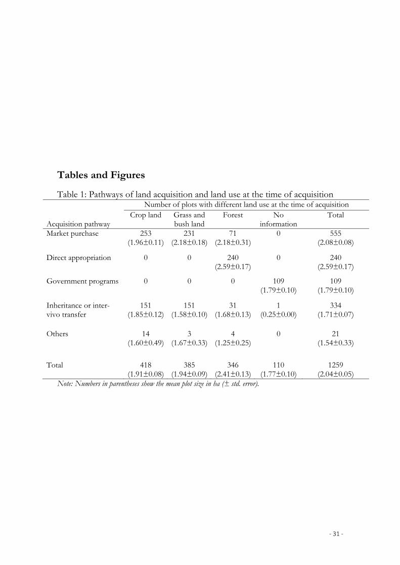
‐ 31 ‐
Tables and Figures
Table 1: Pathways of land acquisition and land use at the time of acquisition
Acquisition pathway
Number of plots with different land use at the time of acquisition Crop land Grass and
bush land Forest No
information Total
Market purchase 253 (1.96±0.11)
231 (2.18±0.18)
71 (2.18±0.31)
0
555 (2.08±0.08)
Direct appropriation 0
0
240 (2.59±0.17)
0
240 (2.59±0.17)
Government programs 0
0
0
109 (1.79±0.10)
109 (1.79±0.10)
Inheritance or inter-vivo transfer
151 (1.85±0.12)
151 (1.58±0.10)
31 (1.68±0.13)
1 (0.25±0.00)
334 (1.71±0.07)
Others 14 (1.60±0.49)
3 (1.67±0.33)
4 (1.25±0.25)
0
21 (1.54±0.33)
Total 418 (1.91±0.08)
385 (1.94±0.09)
346 (2.41±0.13)
110 (1.77±0.10)
1259 (2.04±0.05)
Note: Numbers in parentheses show the mean plot size in ha (± std. error).
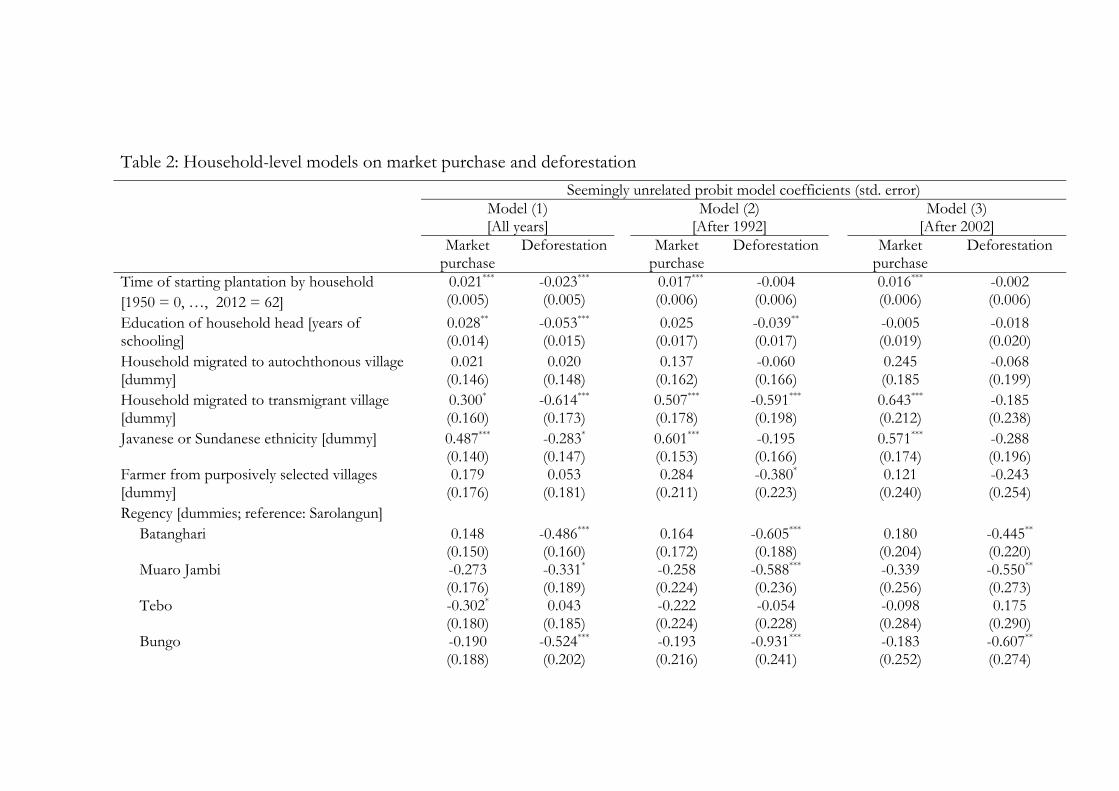
Table 2: Household-level models on market purchase and deforestation
Seemingly unrelated probit model coefficients (std. error) Model (1) Model (2) Model (3) [All years] [After 1992] [After 2002]
Market purchase
Deforestation Market purchase
Deforestation Market purchase
Deforestation
Time of starting plantation by household [1950 = 0, …, 2012 = 62]
0.021*** (0.005)
-0.023*** (0.005)
0.017*** (0.006)
-0.004 (0.006)
0.016*** (0.006)
-0.002 (0.006)
Education of household head [years of schooling]
0.028** (0.014)
-0.053*** (0.015)
0.025 (0.017)
-0.039** (0.017)
-0.005 (0.019)
-0.018 (0.020)
Household migrated to autochthonous village [dummy]
0.021 (0.146)
0.020 (0.148)
0.137 (0.162)
-0.060 (0.166)
0.245 (0.185
-0.068 (0.199)
Household migrated to transmigrant village [dummy]
0.300* (0.160)
-0.614*** (0.173)
0.507*** (0.178)
-0.591*** (0.198)
0.643*** (0.212)
-0.185 (0.238)
Javanese or Sundanese ethnicity [dummy] 0.487*** (0.140)
-0.283* (0.147)
0.601*** (0.153)
-0.195 (0.166)
0.571*** (0.174)
-0.288 (0.196)
Farmer from purposively selected villages [dummy]
0.179 (0.176)
0.053 (0.181)
0.284 (0.211)
-0.380* (0.223)
0.121 (0.240)
-0.243 (0.254)
Regency [dummies; reference: Sarolangun] Batanghari 0.148
(0.150) -0.486*** (0.160)
0.164 (0.172)
-0.605*** (0.188)
0.180 (0.204)
-0.445** (0.220)
Muaro Jambi -0.273 (0.176)
-0.331* (0.189)
-0.258 (0.224)
-0.588*** (0.236)
-0.339 (0.256)
-0.550** (0.273)
Tebo -0.302* (0.180)
0.043 (0.185)
-0.222 (0.224)
-0.054 (0.228)
-0.098 (0.284)
0.175 (0.290)
Bungo -0.190 (0.188)
-0.524*** (0.202)
-0.193 (0.216)
-0.931*** (0.241)
-0.183 (0.252)
-0.607** (0.274)
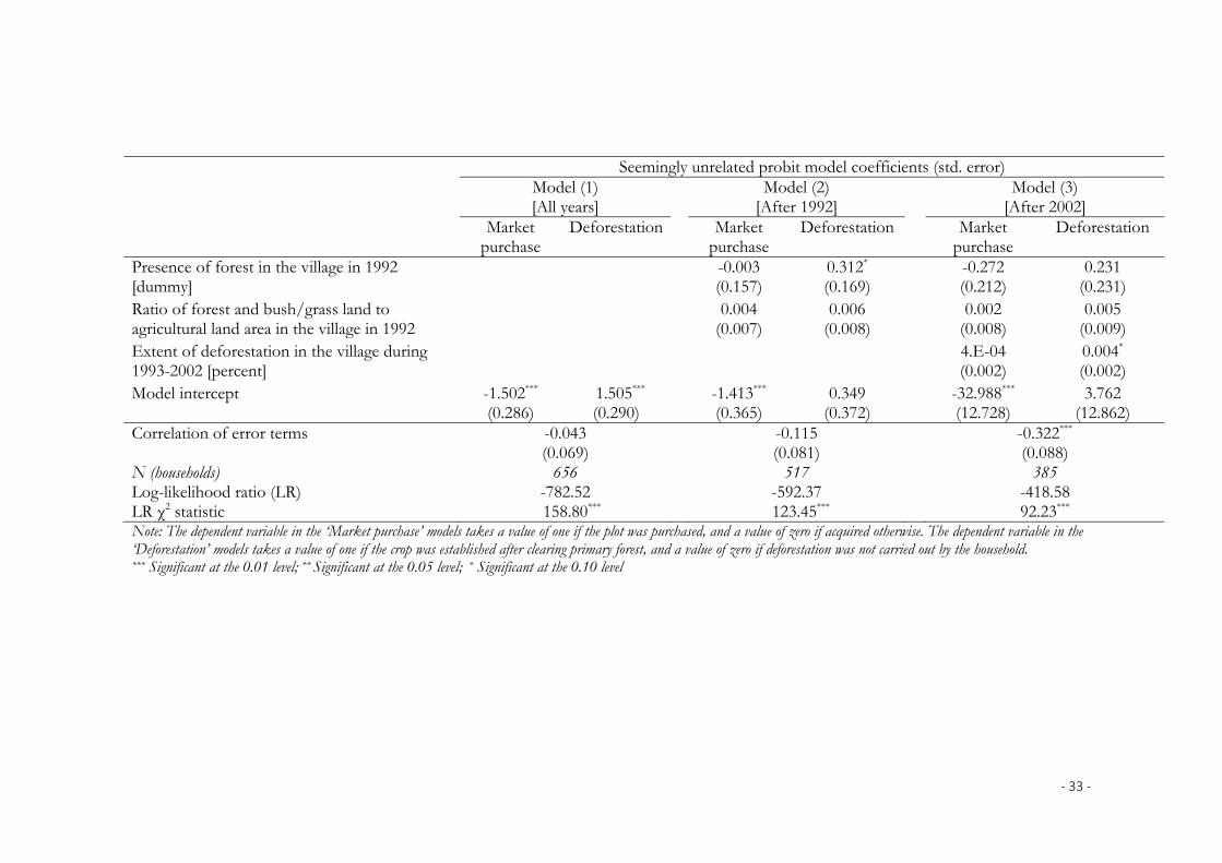
‐ 33 ‐
Seemingly unrelated probit model coefficients (std. error) Model (1) Model (2) Model (3) [All years] [After 1992] [After 2002]
Market purchase
Deforestation Market purchase
Deforestation Market purchase
Deforestation
Presence of forest in the village in 1992 [dummy]
-0.003 (0.157)
0.312* (0.169)
-0.272 (0.212)
0.231 (0.231)
Ratio of forest and bush/grass land to agricultural land area in the village in 1992
0.004 (0.007)
0.006 (0.008)
0.002 (0.008)
0.005 (0.009)
Extent of deforestation in the village during 1993-2002 [percent]
4.E-04 (0.002)
0.004* (0.002)
Model intercept -1.502*** (0.286)
1.505*** (0.290)
-1.413*** (0.365)
0.349 (0.372)
-32.988*** (12.728)
3.762 (12.862)
Correlation of error terms -0.043 (0.069)
-0.115 (0.081)
-0.322*** (0.088)
N (households) 656 517 385 Log-likelihood ratio (LR) -782.52 -592.37 -418.58 LR χ2 statistic 158.80*** 123.45*** 92.23*** Note: The dependent variable in the ‘Market purchase’ models takes a value of one if the plot was purchased, and a value of zero if acquired otherwise. The dependent variable in the ‘Deforestation’ models takes a value of one if the crop was established after clearing primary forest, and a value of zero if deforestation was not carried out by the household. *** Significant at the 0.01 level; ** Significant at the 0.05 level; * Significant at the 0.10 level
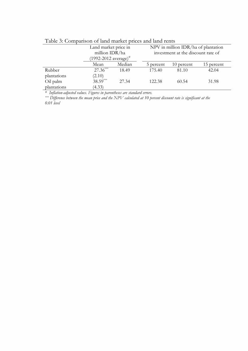
Table 3: Comparison of land market prices and land rents Land market price in
million IDR/ha (1992-2012 average)#
NPV in million IDR/ha of plantation investment at the discount rate of
Mean Median 5 percent 10 percent 15 percent Rubber plantations
27.36*** 18.49 175.40 81.10 42.04 (2.10)
Oil palm plantations
38.59*** 27.34 122.38 60.54 31.98 (4.33)
# Inflation-adjusted values. Figures in parentheses are standard errors. *** Difference between the mean price and the NPV calculated at 10 percent discount rate is significant at the 0.01 level
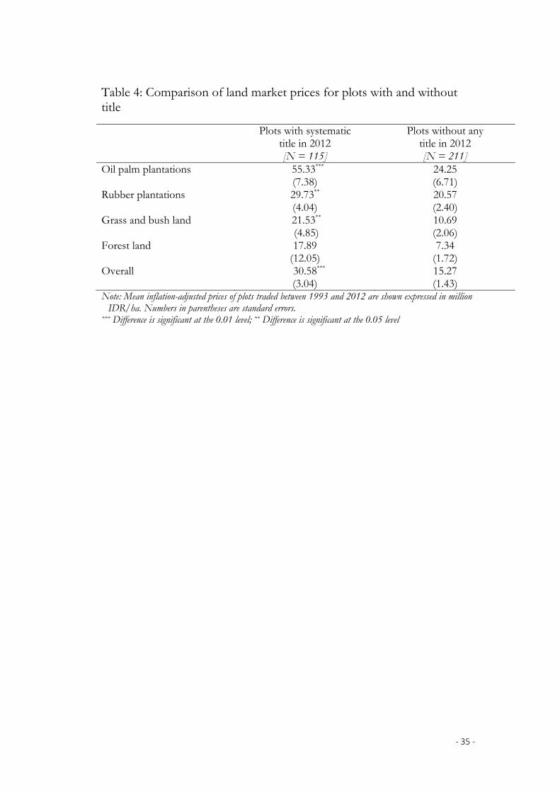
‐ 35 ‐
Table 4: Comparison of land market prices for plots with and without title
Plots with systematic title in 2012 [N = 115]
Plots without any title in 2012 [N = 211]
Oil palm plantations 55.33*** (7.38)
24.25 (6.71)
Rubber plantations 29.73** (4.04)
20.57 (2.40)
Grass and bush land 21.53** (4.85)
10.69 (2.06)
Forest land 17.89 (12.05)
7.34 (1.72)
Overall 30.58*** (3.04)
15.27 (1.43)
Note: Mean inflation-adjusted prices of plots traded between 1993 and 2012 are shown expressed in million IDR/ha. Numbers in parentheses are standard errors.
*** Difference is significant at the 0.01 level; ** Difference is significant at the 0.05 level

‐ 36 ‐
Table 5: Hedonic models of land price Coefficients (std. error) of Box-Cox
model Model (1) Model (2)
Year of transaction [1992 = 42, .. , 2012 = 62] -1.564*** (0.203)
Square of year of transaction 0.015*** (0.002)
Export price of palm oil [thousand IDR/kg; 3-year average prior to transaction]
0.565*** (0.110)
Square of export price of palm oil -0.022*** (0.005
Rubber to palm oil price ratio [ratio of 3-year price averages prior to transaction]
1.791** (0.902
Square of rubber to palm oil price ratio -0.256 (0.174)
Plot size [ha] -0.163*** (0.050)
-0.170*** (0.050)
Square of plot size 0.011*** (0.003)
0.011*** (0.003)
Land use at time of transaction [reference: bush and grass lands]
Oil palm [dummy] 5.541*** (2.233)
1.436*** (0.200)
Oil palm * Year of transaction -0.074* (0.041)
Plantation rubber [dummy] -0.677 (1.409)
0.980*** (0.141)
Plantation rubber * Year of transaction 0.031 (0.026)
Jungle rubber [dummy] 0.062 (2.257)
-0.052 (0.210)
Jungle rubber * Year of transaction -0.003 (0.041)
Other crops [dummy] -2.036 (4.584)
-0.228 (0.391)
Other crops * Year of transaction 0.033 (0.084)
Forest [dummy] 3.098* (1.853)
-0.393** (0.192)
Forest * Year of transaction -0.067* (0.035)
Plot in transmigrant village [dummy] 0.644*** (0.149)
0.594*** (0.148)
Plot in purposively selected village [dummy] -0.003 (0.173)
-0.058 (0.171)
‐ 37 ‐
Coefficients (std. error) of Box-Cox model
Model (1) Model (2) Regency [reference: Sarolangun]
Batanghari -0.038 (0.146)
-0.034 (0.145)
Muaro Jambi 0.005 (0.217)
-0.052 (0.215)
Tebo 0.167 (0.213)
0.230 (0.213)
Bungo 0.559** (0.237)
0.523** (0.237)
Model intercept 42.836*** (5.277)
-3.763*** (1.373)
Box-Cox transformation parameter 0.086*** (0.026)
0.076*** (0.026)
Adj. R2 0.33 0.30 N (plots) 563 563
Note: Only plots that were traded in the market – the plots purchased by the sample farmers (N = 555) and the plots sold by them (N = 8) – are included.. *** Significant at the 0.01 level; ** Significant at the 0.05 level; * Significant at the 0.10 level
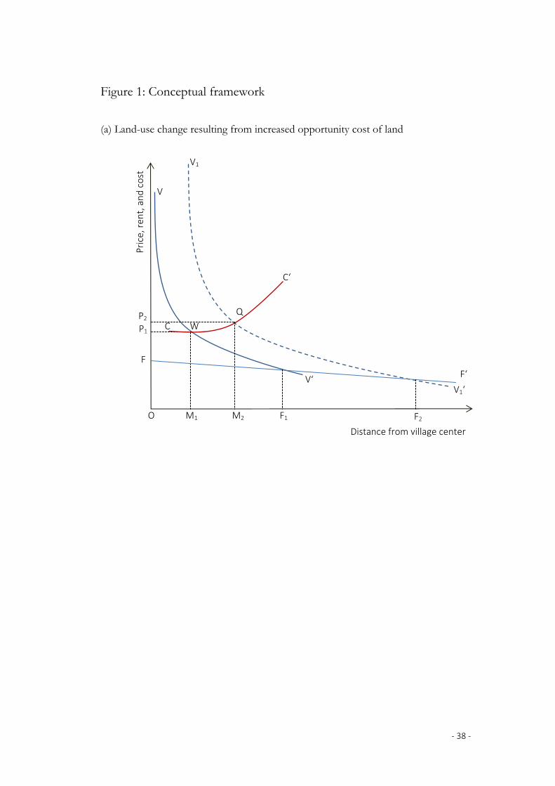
‐ 38 ‐
Figure 1: Conceptual framework
(a) Land-use change resulting from increased opportunity cost of land
C
O M1 M2
P2
Distance from village center
Price, ren
t, and cost
V
V‘
V1
V1‘
C‘
F
F‘
F1 F2
W
Q
P1

‐ 39 ‐
(b) Land-use change resulting from speculative trading
Px1 Cx
Px2
M1* M3
*
Pn
Distance from village center
Price, ren
t, and cost
V
V‘
V1
Cx‘
Cn
Cn‘
M2*
F
F‘
F1 O
R
S
T
V1‘
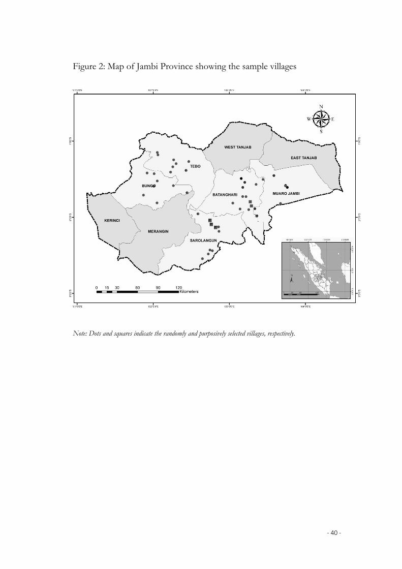
‐ 40 ‐
Figure 2: Map of Jambi Province showing the sample villages
Note: Dots and squares indicate the randomly and purposively selected villages, respectively.
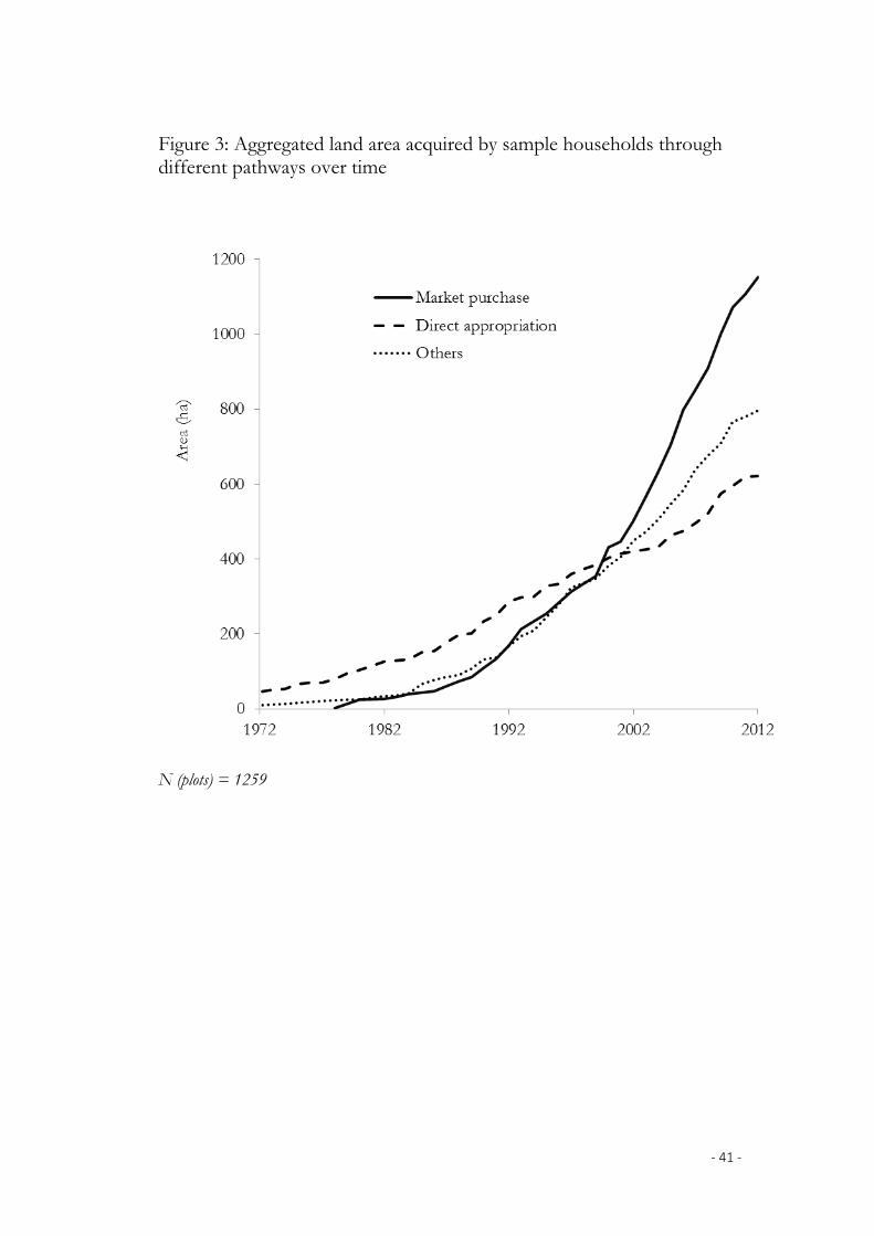
‐ 41 ‐
Figure 3: Aggregated land area acquired by sample households through different pathways over time
N (plots) = 1259

‐ 42 ‐
Figure 4: Aggregated area deforested and purchased by sample households over time
N (plots) = 1259
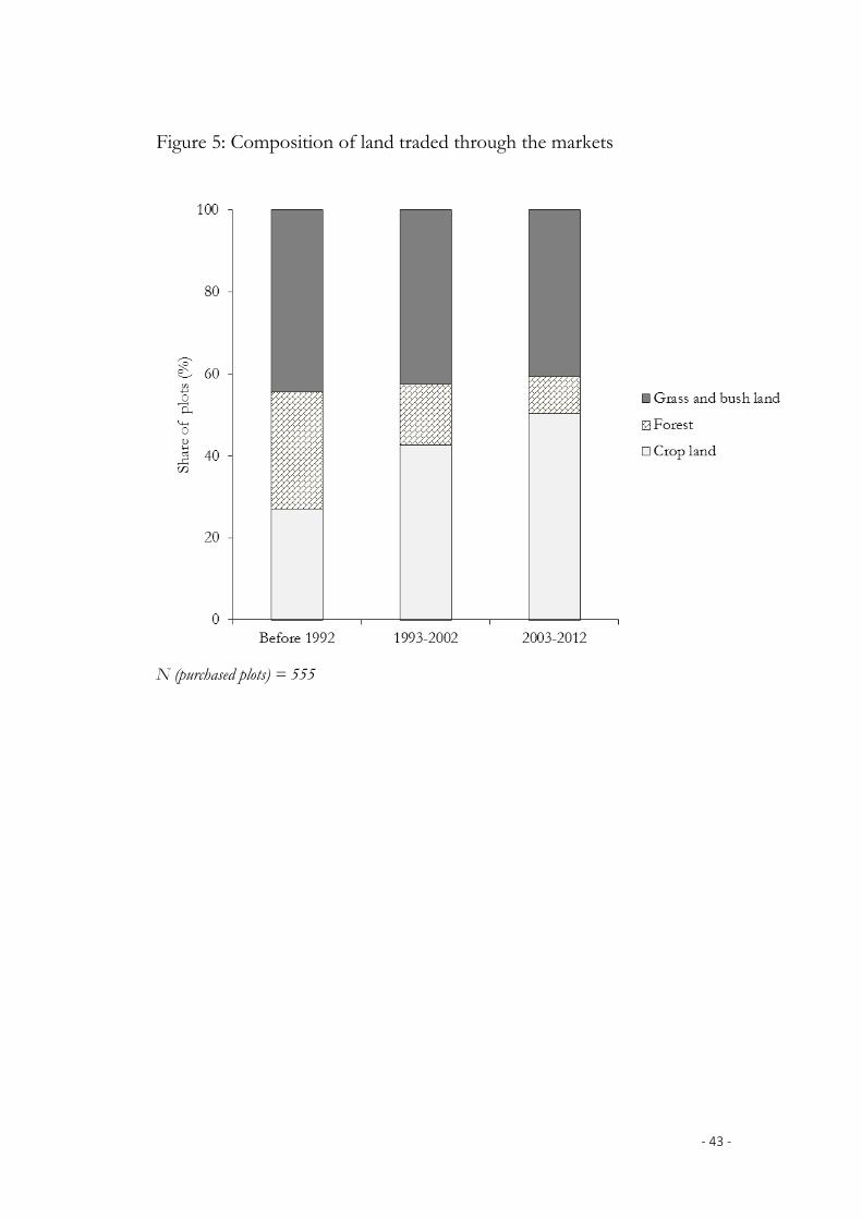
‐ 43 ‐
Figure 5: Composition of land traded through the markets
N (purchased plots) = 555
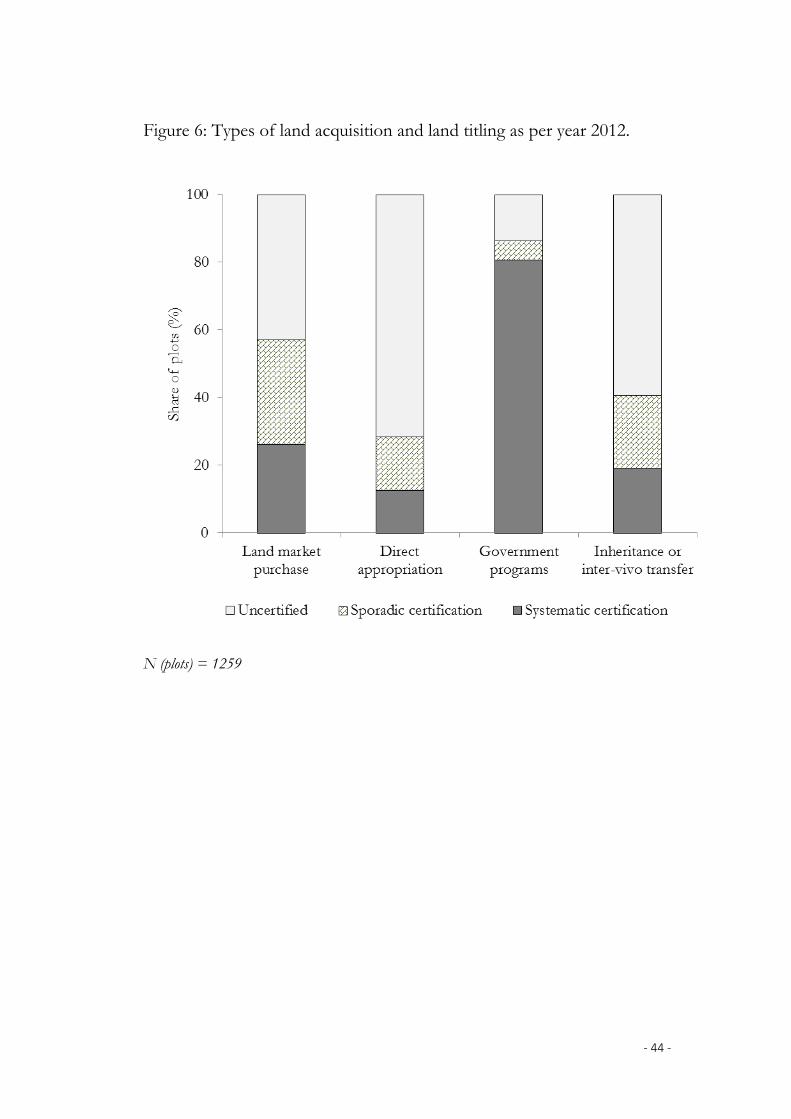
‐ 44 ‐
Figure 6: Types of land acquisition and land titling as per year 2012.
N (plots) = 1259
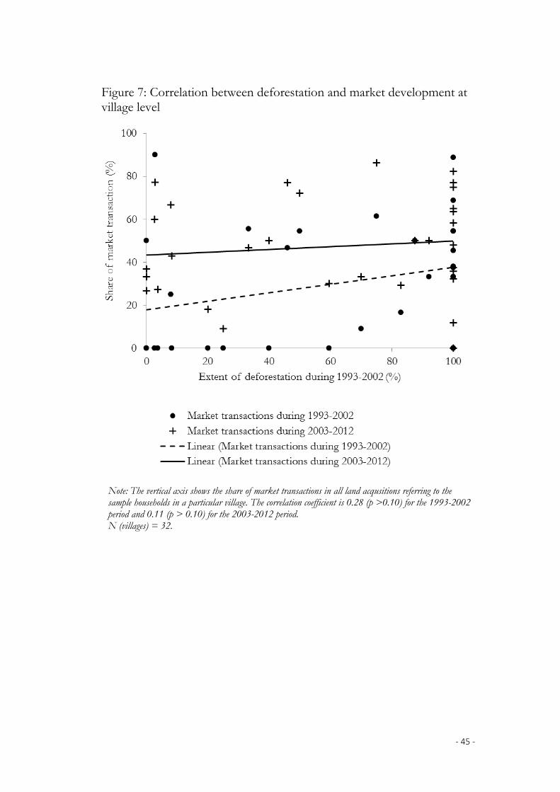
‐ 45 ‐
Figure 7: Correlation between deforestation and market development at village level
Note: The vertical axis shows the share of market transactions in all land acqusitions referring to the sample households in a particular village. The correlation coefficient is 0.28 (p >0.10) for the 1993-2002 period and 0.11 (p > 0.10) for the 2003-2012 period. N (villages) = 32.
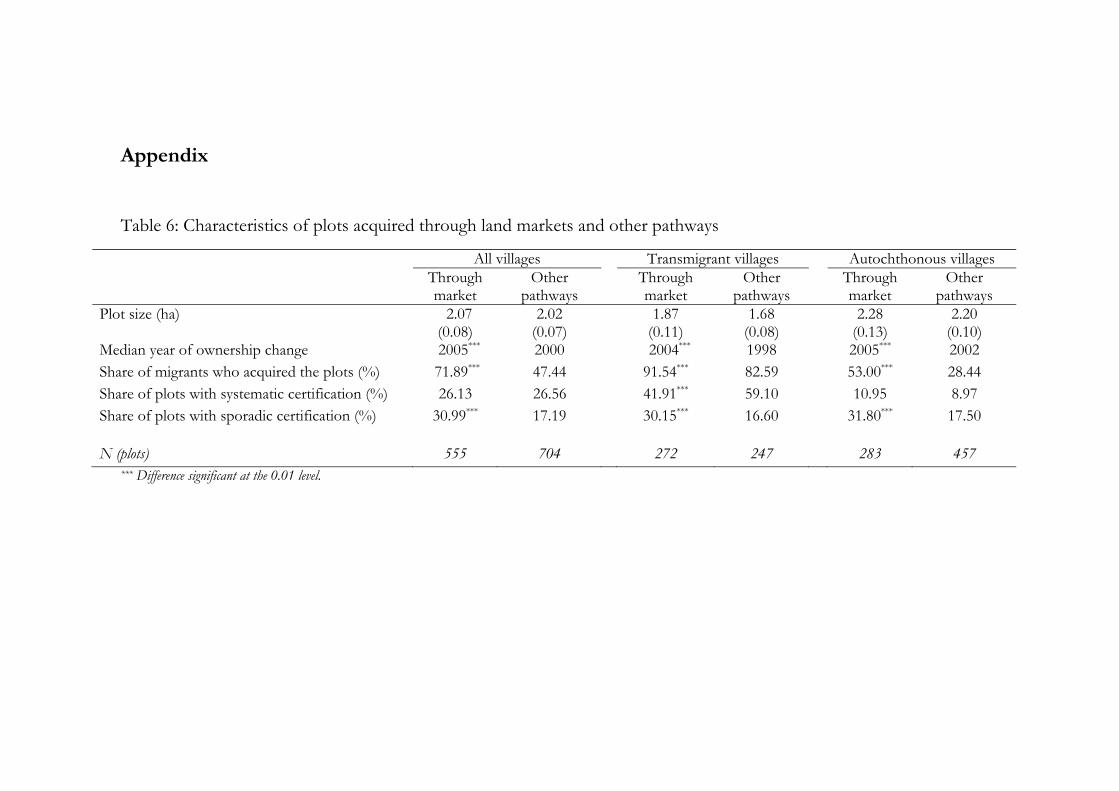
Appendix
Table 6: Characteristics of plots acquired through land markets and other pathways
All villages Transmigrant villages Autochthonous villages Through market
Other pathways
Through market
Other pathways
Through market
Other pathways
Plot size (ha) 2.07 (0.08)
2.02 (0.07)
1.87 (0.11)
1.68 (0.08)
2.28 (0.13)
2.20 (0.10)
Median year of ownership change 2005*** 2000 2004*** 1998 2005*** 2002 Share of migrants who acquired the plots (%) 71.89*** 47.44 91.54*** 82.59 53.00*** 28.44 Share of plots with systematic certification (%) 26.13 26.56 41.91*** 59.10 10.95 8.97 Share of plots with sporadic certification (%) 30.99*** 17.19 30.15*** 16.60 31.80*** 17.50
N (plots) 555 704 272 247 283 457 *** Difference significant at the 0.01 level.

Table 7: Plot-level models explaining market purchase versus direct appropriation
Probit coefficients (std. error) Model (1) Model (2) Model (3) [All years] [1993-2012] [2003-2012]
Time of land acquisition [1950 = 0, …, 2012 = 62] 0.059*** (0.007)
0.045*** (0.013)
-0.002 (0.035)
Household with no land under plantation at time of acquisition [dummy]
0.134 (0.122)
0.096 (0.145)
0.204 (0.197)
Distance from place of residence to plot [km] -0.019** (0.008)
-0.020** (0.009)
-0.021** (0.010)
Square of distance from place of residence to plot
1.E-04* (5.E-05)
1.E-04 (6.E-05)
1.E-04* (6.E-05)
Education of household head [years of schooling] 0.056*** (0.016)
0.059*** (0.019)
0.046* (0.024)
Household migrated to autochthonous village [dummy]
0.031 (0.146)
0.173 (0.171)
0.108 (0.220)
Household migrated to transmigrant village [dummy]
0.784*** (0.181)
0.950*** (0.222)
0.616** (0.289)
Javanese or Sundanese ethnicity [dummy] 0.840*** (0.148)
0.971*** (0.172)
0.945*** (0.218)
Farmer from purposively selected villages [dummy] 0.219 (0.170)
0.589*** (0.223)
0.478* (0.289)
Regency [dummies; reference: Sarolangun] Batanghari 0.409***
(0.161) 0.605***
(0.198) 0.319
(0.260) Muaro Jambi 0.247
(0.212) 0.595
(0.274) 0.384
(0.350) Tebo -0.350*
(0.188) -0.185** (0.234)
-0.183 (0.320)
Bungo 0.653*** (0.227)
0.962*** (0.284)
0.730** (0.366)
Presence of forest in the village in 1992 [dummy] -0.531*** (0.192)
-0.564** (0.280)
Ratio of forest and bush/grass land to agricultural land area in the village in 1992
0.009 (0.012)
0.008 (0.014)
Extent of deforestation in the village during 1993-2002 [percent]
-0.002 (0.003)
Model intercept -3.626*** (0.412)
-2.848*** (0.771)
0.299 (2.039)
N (plots) 795 610 380 Log-likelihood ratio (LR) -335.98 -236.80 -140.83 LR χ2 statistic 301.84*** 186.01*** 84.37***
Note: The dependent variable in all three models takes a value of one if the plot was purchased, and a value of zero if acquired through direct appropriation of forestland. *** Significant at the 0.01 level; ** Significant at the 0.05 level; * Significant at the 0.10 level