Embed Size (px)
Citation preview
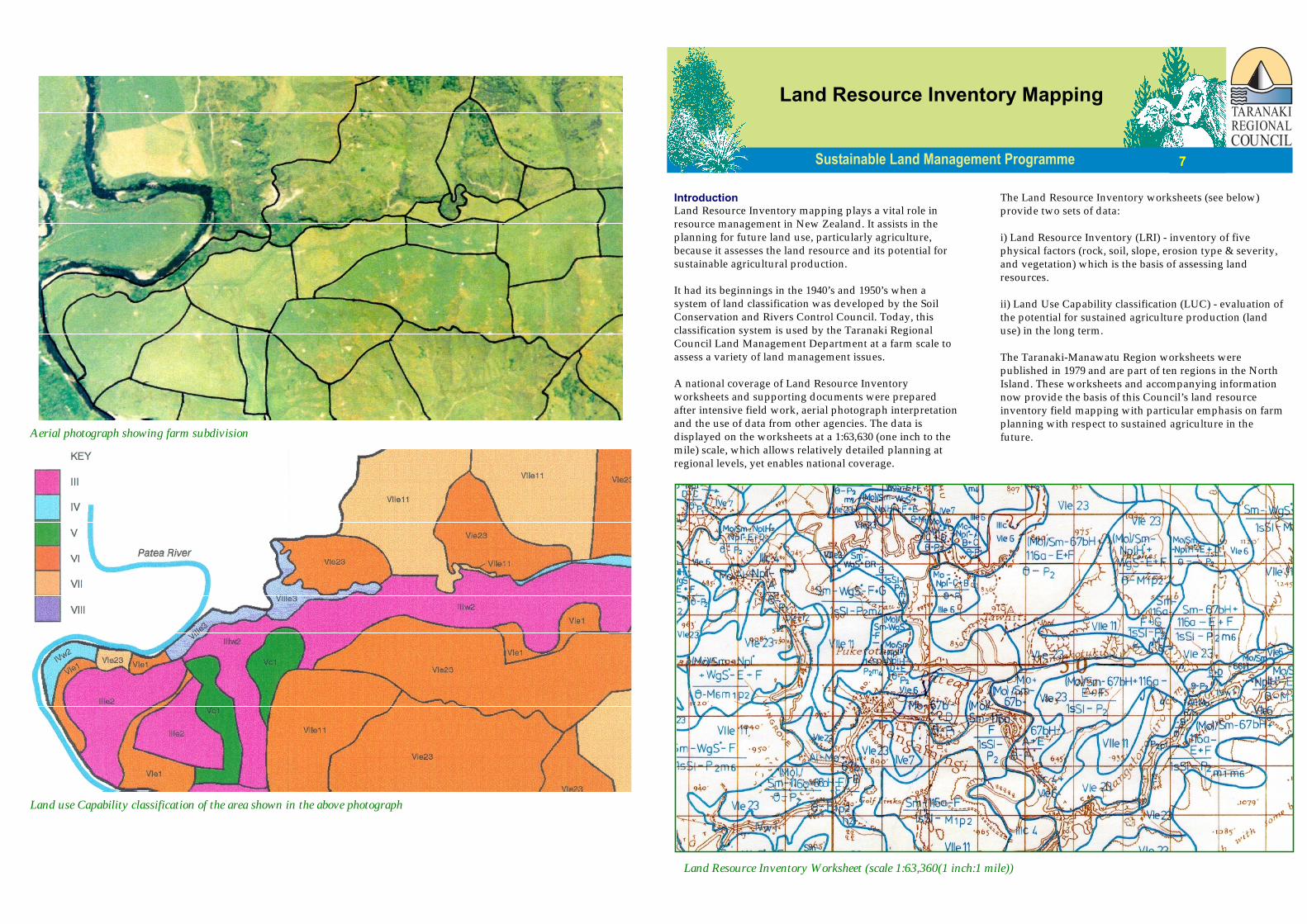
Aerial photograph showing farm subdivision
Land use Capability classification of the area shown in the above photograph
IntroductionLand Resource Inventory mapping plays a vital role inresource management in New Zealand. It assists in theplanning for future land use, particularly agriculture,because it assesses the land resource and its potential forsustainable agricultural production.
It had its beginnings in the 1940’s and 1950’s when asystem of land classification was developed by the SoilConservation and Rivers Control Council. Today, thisclassification system is used by the Taranaki RegionalCouncil Land Management Department at a farm scale toassess a variety of land management issues.
A national coverage of Land Resource Inventoryworksheets and supporting documents were preparedafter intensive field work, aerial photograph interpretationand the use of data from other agencies. The data isdisplayed on the worksheets at a 1:63,630 (one inch to themile) scale, which allows relatively detailed planning atregional levels, yet enables national coverage.
The Land Resource Inventory worksheets (see below)provide two sets of data:
i) Land Resource Inventory (LRI) - inventory of fivephysical factors (rock, soil, slope, erosion type & severity,and vegetation) which is the basis of assessing landresources.
ii) Land Use Capability classification (LUC) - evaluation ofthe potential for sustained agriculture production (landuse) in the long term.
The Taranaki-Manawatu Region worksheets werepublished in 1979 and are part of ten regions in the NorthIsland. These worksheets and accompanying informationnow provide the basis of this Council’s land resourceinventory field mapping with particular emphasis on farmplanning with respect to sustained agriculture in thefuture.
Land Resource Inventory Mapping
7
Land Resource Inventory Worksheet (scale 1:63,360(1 inch:1 mile))
Land Resource Inventory DataThe Land Resource Inventory components are recorded in theform of a code for each mapped unit:
Rock Type - Soil Unit - Slope GroupErosion Severity & Type - Vegetation Cover
The code is enclosed by a boundary, which indicates that theinformation mapped is homogeneous throughout that area(within the limitations imposed by the scale of mapping). Anew inventory area is mapped where any one factor changes.Each code is explained in an attached legend. These factorsdetermine the Land Use Capability (LUC) of each map unit.
ClimateClimate is an integral physical factor in the assessment ofLand Use Capability. Climatic data determines the suitabilityof the land for pastoral, cropping, horticulture, and forestryuse. It determines how soil-building processes take place andtherefore determines the productivity of the site. This factor isnot recorded directly in the survey process. Climate alsoaffects the erosion processes and likely soil conservationmeasure suitable for a Land Use Capability unit.
Rock TypeThe most frequent rock types in Taranaki are sedimentarysandstone, mudstone and indurated greywacke. In most casesthese rocks are overlain by volcanic tephra, alluvium, loess,and wind blown sand. The rock type directly influences thesoil type, surface stability and land use of any site.
SoilSoil information is based on the New Zealand Soil Bureau soilsurvey. Typical soils listed for the Taranaki-Manawatu Regionare listed in the Land Use Capability Extended Legend. Soildescription and interpretation can be gained from a numberof sources (appropriate soil maps and associated reports)which provide details about the properties of a soil, itspotential uses and productive potential.
SlopeSlope angles are measured, or estimated visually in the fieldand/or from aerial photographs. The dominant slope isrecorded for each map unit as one of seven groups, each ofwhich have different management characteristics.
ErosionErosion severity and type is assessed essentially by field workas well as aerial photograph interpretation, aided by theknowledge of rock, soil and climate factors which directlyaffect the erosion land use pattern. Erosion types in Taranakiinclude: soil slip; sheet; debris avalanche; wind; streambank;scree; earthflow; gully; slump; earth slip; deposition; rill; andno erosion. The severity of the erosion is recorded as either a
percentage of bare ground (generally sheet, wind, screeerosion) or according to a scale (insignificant to extreme).
VegetationVegetative cover is essentially derived from fieldwork as wellas aerial photograph analysis, supplemented by publishedmaps and descriptions for forest areas. Vegetative cover foreach map unit is recorded as one of five major groups:grassland, cropland, scrubland, forest, and miscellaneousweeds, herbs etc.
Land Use Capability ClassificationLand Use Capability classification is described as a“systematic arrangement of different kinds of land accordingto those properties that determine its capacity for permanentsustained production”. The word capacity is used in the senseof “suitability for productive use” after taking into accountphysical limitations, management requirements, and soilconservation needs the land may have. The Land UseCapability classification is based on an interpretation of thephysical information in the Land Resource Inventory,supplemented with information on climate and the effects ofpast land use which are only undertaken by trainedprofessionals.
There are three components associated with the Land UseCapability classification - a class, subclass and unit.
Land Use Capability ClassThere are eight Land Use Capability classes. Simply, landclasses I to IV are suitable for pastoral, arable, and forestry usewhile Classes V to VII land is suitable for pastoral or forestryuse. Class VIII land is suitable for protection purposes only.
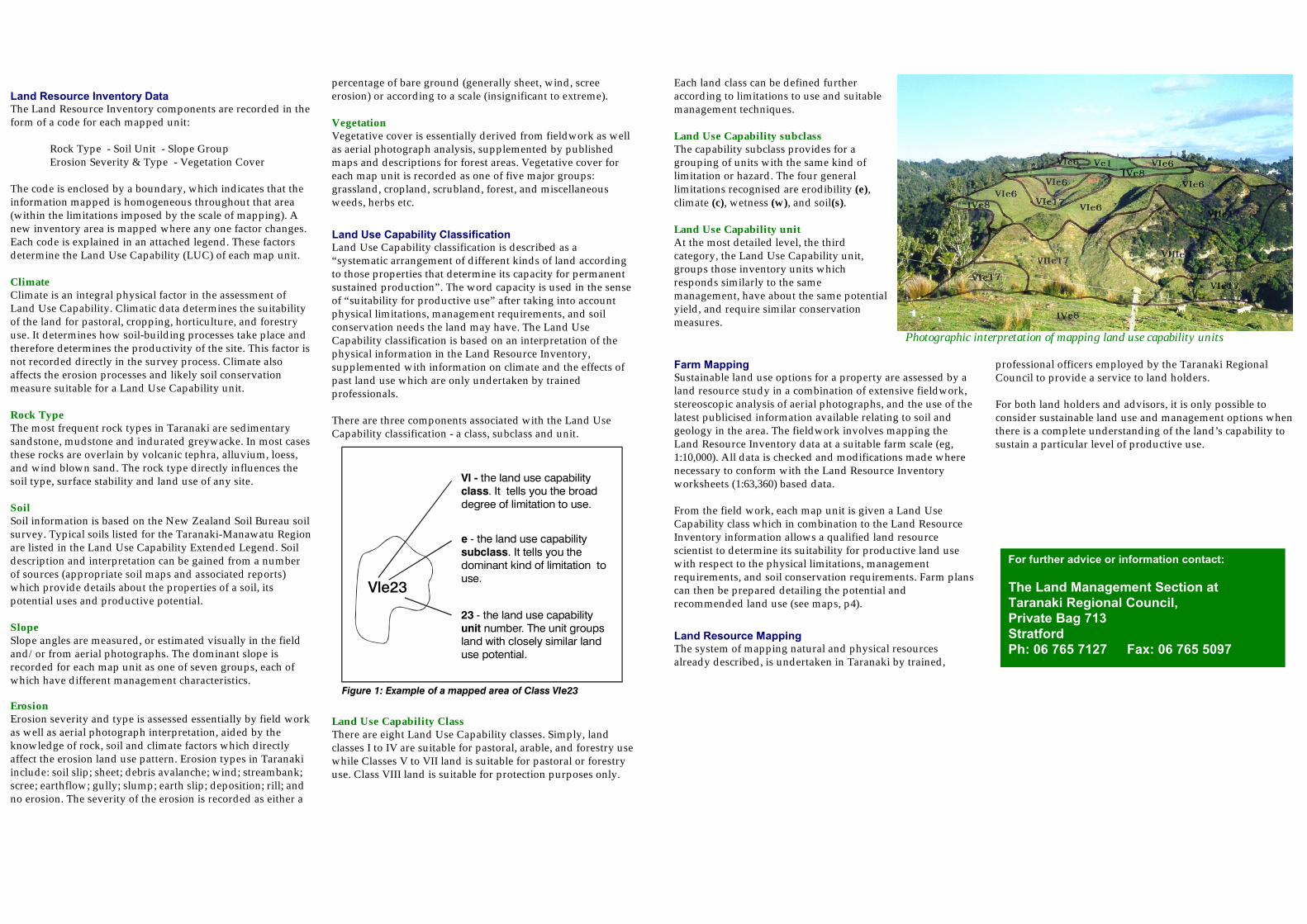
Vle23
esubclass
- the land use capability . It tells you the
dominant kind of limitation to use.
23unit
- the land use capability number. The unit groups
land with closely similar land use potential.
Vl -class
the land use capability . It tells you the broad
degree of limitation to use.
Figure 1: Example of a mapped area of Class VIe23
Each land class can be defined furtheraccording to limitations to use and suitablemanagement techniques.
Land Use Capability subclassThe capability subclass provides for agrouping of units with the same kind oflimitation or hazard. The four generallimitations recognised are erodibility (e),climate (c), wetness (w), and soil(s).
Land Use Capability unitAt the most detailed level, the thirdcategory, the Land Use Capability unit,groups those inventory units whichresponds similarly to the samemanagement, have about the same potentialyield, and require similar conservationmeasures.
Farm MappingSustainable land use options for a property are assessed by aland resource study in a combination of extensive fieldwork,stereoscopic analysis of aerial photographs, and the use of thelatest publicised information available relating to soil andgeology in the area. The fieldwork involves mapping theLand Resource Inventory data at a suitable farm scale (eg,1:10,000). All data is checked and modifications made wherenecessary to conform with the Land Resource Inventoryworksheets (1:63,360) based data.
From the field work, each map unit is given a Land UseCapability class which in combination to the Land ResourceInventory information allows a qualified land resourcescientist to determine its suitability for productive land usewith respect to the physical limitations, managementrequirements, and soil conservation requirements. Farm planscan then be prepared detailing the potential andrecommended land use (see maps, p4).
Land Resource MappingThe system of mapping natural and physical resourcesalready described, is undertaken in Taranaki by trained,
professional officers employed by the Taranaki RegionalCouncil to provide a service to land holders.
For both land holders and advisors, it is only possible toconsider sustainable land use and management options whenthere is a complete understanding of the land’s capability tosustain a particular level of productive use.
For further advice or information contact:
The Land Management Section atTaranaki Regional Council,Private Bag 713StratfordPh: 06 765 7127 Fax: 06 765 5097
Photographic interpretation of mapping land use capability units