Embed Size (px)
Citation preview
34
Map 23
u T A H COLORADO __ _ _ __ _ _ 0- - - -- -
COLORADO
PLATEAU LAND SUBSIDENCE, EARTII FISSURES, AND WATER-LEVEL
CHANGE IN SOUTHERN ARIZONA
- -,
/ l/ _ /' '
I
? o
\...
? ,
\
> (
')
w )
\
z i
'" \
'" "'- ~
"'- ')
'j
!
l (
" \ \ ,
\ z
C "
a:
)
0 ./
(
'-J
LL. w 0 (jj 0: W 2 0:
...J
0 ..J -< (! w (L
::E
, ~
Scale 1 1000 000
)
\ /
"\ I '. ----- ...
" "\
/
./
CI D
D
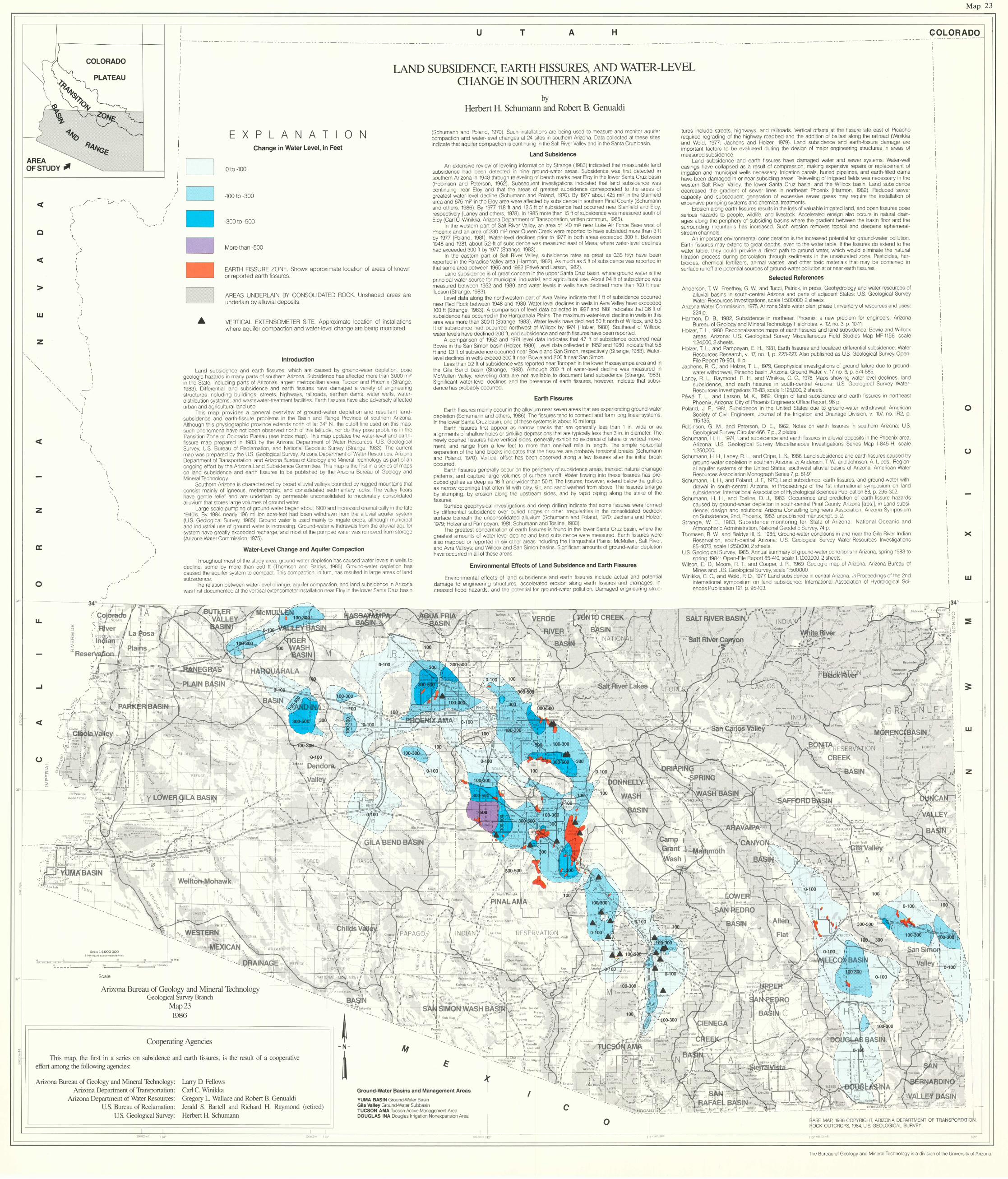
E X P L A N A T 0 N Change in Water Level, in Feet
o to -100
-100 to -300
-300 to -500
More than -500
EARTH FISSURE ZONE Shows approximate location of areas of known or reported earth fissures
AREAS UNDERLAIN BY CONSOLIDATED ROCK Unshaded areas are underlain by allUVial depOSits
VERTICAL EXTENSOMETER SITE ApprOXimate location of Installat tons where aqUifer compaction and water- level change are being monitored
Introduction
Land subSidence and earth fissures which are caused by ground water depletion pose geolog IC hazards In many parts of southern Anzona SubSidence has affected more than 3000 ml2
In the Stale, Including parts of Anzonas largest metropolitan areas Tucson and PhoeniX (Strange, 1983) Differential land subSidence and earth fissures have damaged a vanely of englneenng structures Including bUild ings, streets, highways railroads earthen dams water wells, waterdistribution syslems and wastewater-treatment faCilities Eartl l fissures have also adversely affected urban and agricultural land use
Th iS map p rOVides a general overview of ground -water depletion and resultant landsubSidence and earth fissure problems In the BaSin and Range Province of southern Arizona Although thiS phYSiographic province extends north of lat 340 N tile culoff line used on thiS map such phenomena have not been observed north of thiS latitude nor do they pose problems In the TranSition Zone or Colorado Plateau (see Index map) ThiS map updates the water-level and ear thfissure map prepared In 1983 by the Arizona Department of Water Resources U S Geological Survey, US Bureau of Reclamation, and National GeodetiC Survey (Slrange 1983) The current map was prepared by the U S Geological Survey, Anzona Department of Water Resources Arizona Department of Transportation and Anzona Bureau of Geology and Minerai Technology as part of an ongoing effort by the Anzona Land SubSidence Committee ThiS map IS the fllst In a senes of maps on land subSidence and earth fissu res to be published by the Anzona Bureau of Geology and Minerai Technology
Soulhern Anzona IS characterized by broad allUVial valleys bounded by rugged mountains that consist mainly of Igneous metamorphic, and consolidated sedimentary rocks The va lley floors have gentle relief and are underlain by permeable unconsol idated to moderately consolidated allUVium that stores large volumes of ground water
Large-scale pumping 01 ground water began about t900 and Increased dramatically '" the late 1940's By t984 nearly 196 mill ion acre-feet had been Withdrawn from the allUVial aqUifer system (U S Geological Survey, 1985) Ground waler IS used mainly to IlIIgate crops although muniCipal and Industnal use of ground water IS Increasing Ground-water Wi thdrawals Irom tile allUVial aqUifer system have greatly exceeded recharge and most of the pumped water was removed Irom slorage (Anzona Water Commission, 1975)
Water-Level Change and Aquifer Compaction
Throughout most of tile study arca ground-water depletion has caused waler levels In wells to decline, some by more Ihan 550 It (Thomsen and Baldys 1985) Ground-water depletion has caused the aqUifer system to compact ThiS compaction In turn has resulted In large areas of land subSidence
The relat ion bel ween water-level change aqUifer compaction, and land subSidence In Allzona was fllSI documented at the vert ical extensometer Installation near Eloy In the lower Santa Cruz baSin
1~~-=*= -----!,~~ "' '0 0 "",,, ' " Me,..,.t •• q=-..3~ ~ ,..--~
Scale
Arizona Bureau of Geology and Mineral Technology Geological Survey Branch
Map 23 1986
Coopemting Agencies
lbis map, the first ill a series on subsidence and earth fissures, IS the result of a cooperative effort among the following agencies:
Arizona Bureau of Geology and Mineral Technology:
,"
~ -----
------N- M
~
by Herbert H. Schumann and Robert B. Genualdi
(Schumann and Poland 1970) Such Installations are being used 10 measure and monitor aquifer compaction and water-level changes at 24 sites In southern Anzona Data collected at these sites Indicate that aqUifer compaction IS continu ing In the Salt River Valley and In the Santa Cruz basin
Land Subsidence
An extensive review of leveling Information by Strange (1983) Indicated that measurable land subSidence had been detected In nine ground-water areas SubSidence was fllst detected In southern Anzona In 1948 through relevehng of bench marks near Eloy In the lower Santa Cruz baSin (Robinson and Peterson 1962) Subsequent Investigations Indicated Ihat land subSidence was continuing near Eloy and that the areas of greatest subSidence corresponded to the areas of greatest water-level decline (Schumann and Poland 1970) By 1977 about 425 ml2 In the Stanfield area and 675 ml2 In the Eloy area were affected by subSidence In southern Pinal County (Schumann and others, 1986) By 1977 118 It and 125ft of subSidence had occurred near Slanlleld and Eloy respectively (Laney and others, 1978) In 1985 more than 15 ft of subSidence was measured south of Eloy (Carl C Wlnlkka, Anzona Department of Transportation, wntten commun 1985)
In the western part of Sail River Valley, an area of 140 ml2 near Luke All Force Base wesl of PhoeniX and an area of 230 ml2 near Queen Creek were reported to have subSided more than 3 ft by 1977 (Poland, 1981) Water-level declines pnor to 1977 In both areas exceeded 300 ft Between 1948 and 1981, about 52 It of subSidence was measured east of Mesa where water-level declines had exceeded 300 ft by 1977 (Strange 1983)
In the eastern part of Sa lt River Valley subSidence rales as great as 035 ft/yr have been reported In the Parad ise Valley area (Harmon 1982) As much as 5 ft 01 subSidence was reported In that same area between 1965 and 1982 (Pewe and Larson, 1982)
Land subSidence IS of great concern In the upper Santa Cruz baSin where ground water IS the pnnclpal water source for muniCipal, Industnal and agncultural use About 04 It of subSidence was measured between 1952 and 1980, and water levels In wells have decl ined more than 100 It near Tucson (Strange 1983)
Level data along the northwestern part of Avra Valley Indicate that 1 It of subSidence occurred near Red Rock between 1948 and 1980 Water-level declines In wells In Avra Va lley have exceeded 100 ft (Strange, 1983) A companson of level data collected In 1927 and 1981 Indicates that 06 ft of subSidence has occurred In the Harquahala Plains The maximum water-level decline In wells In thiS area was more than 300 ft (Strange 1983) Water levels have declined 50 ft north of Willcox and 53 ft of subSidence had occurred northwest of Wi llcox by 1974 (Holzer, 1980) Southeast of Willcox water levels have declined 200 ft, and subSidence and earth fissures have been reported
A companson of 1952 and 1974 level data Indicates that 47 It 01 subSidence occurred near BOWie In the San Simon baSin (Holzer, 1980) Level data collected In 1952 and 1980 Indicate that 58 ft and 13 ft of subSidence occurred near BOWie and San Simon, respectively (Strange 1983) Waterlevel declines In wells exceed 300 ft near BOWie and 200 ft near San Simon
Less than 02 ft of subSidence was reported near Tonopah rn the lower Hassayampa area and ,n the Gila Bend baSin (Strange, 1983) Although 200 It of water-level decline was measured In McMullen Valley, releveling data are not available to document land subSidence (Strange, 1983) Significant water-level declines and the presence of earth fissures however Indicate that subs l dence has probably occurred
Earth Fissures
Earth fissures main ly occur In the allUVium near seven areas thai are expellenclng ground-water depletion (Schumann and others, 1986) The fissures tend to connect and form long linear systems In the lower Santa Cruz baSin one of these systems IS about 10 ml long
Earth f,ssu res fllst appear as narrow cracks that are generally less than 1 In Wide or as alignments of shallow holes or slnkllke depreSSions that are tYPically less Ihan 3 In In diameter The newly opened fissures have vertical Sides, generally exhibit no eVidence of lateral or vert ical movement, and range from a few feet to more than one-half mile In length The Simple hOllzontal separation of the land blocks Indicates that the fissures are probably tenSional breaks (Schumann and Poland, 1970) Vertical offset has been observed along a few fissures after the Initial break occurred
Earth fissures generally occur on the penphery of subSidence areas, Iransect natural drainage patterns, and capture large volumes of surface runoff Water flOWing Into these I,ssures has produced gullies as deep as 16 ft and Wider than 50 ft The I,ssures however extend below the gullies as narrow open ings that often fi ll With clay, slit and sand washed from above The fissures en large by slumping, by erOSion along the upstream Sides, and by rapid piping along Ihe stnke of the fissures
Surface geophYSical Investigations and deep dniling Indicate that some fissures were formed by differential subSidence over bu ned rrdges or other IIregulantles In the consolidated bedrock surface beneath the unconsolidated allUVium (Schumann and Poland t970, Jachens and Holzer, 1979, Holzer and Pampeyan 1981 Schumann and Tosllne, 1983)
The greatest concentration of earth fissures IS found In the lower Santa Cruz baSin where the greatesl amounts of water-level decline and lalld subSidence were measured Earth I,ssures were also mapped or reported In SIX other areas Including the Harquahala Plains, McMullen Salt River and Avra Valleys, and Willcox and San Simon baSins Signlilcant amounts of ground-water depletion have occurred In all of these areas
Environmental Effects of Land Subsidence and Earth Fissures
Envllonmental effects of land subSidence and earth fissures Include actual and potential damage to englneellng structures, accelerated erOSion along earth fissures and drainages, Increased flocd hazards, and the potential for ground water pollution Damaged englneellng struc-
~
k Arizona Department of TransportatIon:
Arizona Department of Water Resources:
Larry D Fello\\s Carl C Wmikka Gregory L. Wallace and Robert E, Genualdi
Ground-Water Basins and Management Areas
YUMA BASIN Ground Water BaSin I
US. Bureau of Reclamation: US. Geological Survey:
<oc room 114"
Jerald S. Batiell and Richard H. Raymond (retired) Herbert H. Schumann
Gila Valley Ground Waler SubbaSin TUCSON AMA Tucson Acllve Management Area DOUGLAS INA Douglas Illig allan Nonexpanslon Area
c o
11"'oJ! ~ ....
tures Include streets, highways and railroads Vertical offsets at the fissure site east of Picacho requlled regrading of the highway roadbed and the addition of ballast along the railroad (Wlnlkka and Wold, 1977, Jachens and Holzer, 1979) Land subSidence and earth-fissure damage are Important factors to be evalualed dunng the design of major englneenng struclures In areas of measured subSidence
Land subSidence and earth fissures have damaged water and sewer systems Water wel l casings have collapsed as a result of compression making expensive repalls or replacement of IIngatlon and mUnicipal wells necessary Irrigation canals buned pipelines, and earth-filled dams have been damaged In or near subSiding areas Releveling of rrngated fie lds was necessary In the western Salt River Valley the lower Santa Cruz baSin and the Willcox baSin Land subSidence decreased the gradlenl 01 sewer lines In northeast PhoeniX (Harmon, 1982) Reduced sewer capacity and subsequent generation of excessive sewer gases may requlle the Installation of expensive pumping systems and chemical treatments
ErOSion along earth fissures results In the loss of valuable IIngated land, and open fissures pose senous hazards to people, Wildlife, and livestock Accelerated erosrpn also occurs In natural drainages along Ihe penphery of subSiding baSins where the gradient between the baSin floor and the surrounding mountains has Increased Such erosion removes topsoil and deepens ephemeralstream channels
An Important envrronmental conSideration IS the Increased potential for ground water pollution Earth fissures may extend to great depths, even to the water table If Ihe I,ssures do extend to the water table, they could prOVide a dllect path to ground water, which would eliminate the natural fil tration process dunng percolation through sediments In the unsaturated zone Pesticides, herbiCides, chemical fertilizers, animal wastes and other tOXIC matenals Ihat may be contained In surface runoff are potential sources of ground-water pollution at or near earth fissures
Selected References
Anderson T W, Freethey, G Wand TUCCI Patrrck, In press Geohydrology and water resources of allUVial baSins In south-central Anzona and parts of adjacent States US Geological Survey Water-Resources Investigations scale 1500000 2 sheets
Anzona Water Commission, 1975, Arrzona State water plan, phase I, Inventory of resources and uses 224 p
Harmon, DB, 1982 SubSidence In northeast PhoeniX, a new problem for engineers Anzona Bureau of Geology and Minerai Technology Fleldnotes, v 12 no 3 p 10-11
Holzer, T L, 1980, Reconnaissance maps of earth fissures and land subSidence, BOWie and Willcox areas, Anzona US Geological Survey Miscellaneous Field Studies Map MF-1156, scale 1 24,000, 2 sheels
Holzer, T L, and Pampeyan, E H 1981 Earth fissures and localized differential subSidence Waler Resources Research, v 17, no 1, p 223-227 Also published as US Geolog ical Survey Open File Report 79-951 11 P
Jachens, R C, and Holzer T L 1979, GeophYSical Investigations of ground fai lure due to groundwater Withdrawal, Picacho baSin, Arrzona Ground Water v 17, no 6 p 574-585
Laney, R L, Raymond, R Hand W,n,kka C C, 1978, Maps shOWing water level declines , land subSidence and earth fissures In south -central Anzona US Geological Survey WaterResources Investigations 78-83, scale 1 125,000,2 sheets
Pewe, T L , and Larson, M K, 1982, Ongln of land subSidence and earth fissures In northeast PhoeniX, Anzona City of PhoeniX Engineer's Office Report , 98 p
Poland, J F 1981, SubSidence In the United States due to ground-water Withdrawal Amencan Society of CIVi l Engineers, Journal of the Irrigation and Drainage DIVISion, v 107, no IR2, p 115-1 35
Robinson, G M, and Peterson, DE, 1962, Notes on earth fissures In southern Anzona US Geological Survey Cllcular 466 7 p , 2 plates
Schumann, H H , 1974 Land subSidence and earth fissures In al'uv,al depOSits In the PhoeniX area, Anzona US Geological Survey Miscellaneous Investigations Senes Map 1-845-H, scale 1250000
Schumann, H H, Laney, R L, and Cnpe, L S, 1986 Land subSidence and earth fissures caused by ground-water depletion In southern Anzona In Anderson T Wand Johnson A I eds Region al aqUifer systems of the United States, southwest allUVial baSins of Anzona Amencan Water Resources ASSOCiation Monograph Senes 7, p 81-91
Schumann, H H, and Poland, J F, 1970 Land subSidence, earth fissures and ground-water With drawal In south central Anzona In Proceedings of the 1st International symposium on land subSidence International ASSOCiation of Hydrological SCiences Publication 88, p 295 302
Schumann, H H, and Tosllne D J, 1983 Occurrence and prediction of earth-fissure hazards caused by ground-water deplet ion In south-central Pinal County, Anzona labs 1 In Land subSIdence, deSign and solutions ArIZona Consulting Engineers ASSOCiation, Anzona Symposium on SubSidence 2nd PhoeniX 1983, unpublished manuscnpl, p 2
Strange, WE, 1983, SubSidence monltollng for State of Anzona National Oceanic and Atmosphenc Administration Nallonal GeodetiC Survey 74 p
Thomsen, B W, and Baldys II I S, 1985, Ground-water conditions In and near the Gila River Indian Reservation, south-central Anzona US Geological Survey Water-Resources Investigations 85-4073 scale 1 250,000, 2 sheels
US Geological Survey 1985, Annual summary 01 ground-water cond itions In Anzona, spnng 1983 to spring 1984 Open-File Report 85-410 scale 1 1,000,000, 2 sheets
Wilson ED, Moore R T and Cocper, J R 1969 GeologiC map of Arizona Arizona Bureau of Mines and U S Geological Survey, scale 1 500,000
Wlnlkka, C C, and Wold, P D , 1977 Land subSidence In central Anzona 111 Proceedrngs of the 2nd International symposium on land subSidence International ASSOCiation 01 Hydrological SCI ences Publication 121 p 95-103
o
o
x
w
3:
W
-" lilt, " ~
Z
\ I ;); ,
~2-'~~,:;;;~)~II~y'JA,~dL:' ~, 5\ 01
I \
I ,I
I,
I
BASE MAP 1986 COPYRIGHT, ARIZONA DEPARTMENT OF TRANSPORTATIO~ flOCK OUTCROPS, 1984, US GEOLOGICAL SURVEY
1100 109'
~ "
'"
The Bureau of Geology and Minerai Technology IS a d iV IS ion 01 the University of Arizona