Embed Size (px)
Citation preview
Land Urbanization Level of Core Cities in the Silk Road Economic Belt
LI Zhea,*, SUI Dangchenb
International Business School of Shaanxi Normal University, China
a [email protected], b [email protected]
Keywords: Land urbanization level, Silk Road Economic Belt, Evaluation system.
Abstract: With the construction and development of the Silk Road Economic Belt, it is of great
significance to analyze the land urbanization level of cities along the route. This paper established a
new evaluation system, consisting of 11 indexes from 6 aspects, to measure the land urbanization
level of 71 core cities in the Silk Road Economic Belt in 2014.The Principal component analysis
(PCA) method was used to determine weight of indexes and get calculation results. In the course of
these studies, it is visually apparent that spatial differentiation phenomena and unbalanced
development exist both in provincial scale and urban scale. To promote sustainable development of
Silk Road Economic Belt, enhancing the top design, improving the evaluation system, strengthening
the cooperation and handling the relationship between exploitation and protection of resources are
considered effective methods.
1. Introduction
The concept of Silk Road Economic Belt was firstly proposed by the president Xi Jinping in 2013,
which was based on the well-known Old Silk Road in history and expected to make great
contribution to deeper cooperation between Eurasian countries in future. It is of great significance to
construct Silk Road Economic Belt, regarded as one of the important ways to strengthen regional
economic cooperation, accelerate world economic development and optimize China’s layout of city
and population [1]. Undoubtedly, Intensive urbanization process is happening in China, promoting
the urban land expansion, transition of economic structure and population migration, which has
become a hot research area. Under the background of rapid urbanization, the concept of land
urbanization has been proposed as a new object of study and considered as a main component section
of urbanization process. In recent years, the accelerated speed of land urbanization has been much
faster than population urbanization in China [2], leading to a range of issues such as land finance,
chaotic urban layout, land devaluation, and land wastage [3].In order to monitor the change of land
urbanization, a lot of researches concentrated on the analyses of land urbanization, including
measurement, evaluation, spatial-temporal differences and driving forces. Studies, which revealed
that land urbanization level in the coastal areas of eastern China is much higher than that in center and
western China [4], showed the imbalance of urban development, and urban population agglomeration,
industrial growth and investment were believed three drivers [5]. Even through attention has been
paid to the sustainable development ability, competitive capacity and urbanization development of
cities along the Silk Road Economic Belt, few studies attempted to combine the Silk Road Economic
Belt research with land urbanization of cities.
In this paper, we first selected 71 core cities from 9 provinces and municipalities in the Silk Road
Economic Belt as representatives to measure the land urbanization level in 2014 on the basis of
establishing the evaluation system, and analyzed the influencing factors. Finally, the policy
countermeasures and proposals were provided in the rest of the paper. The aim of this paper is
attempting to establish a new evaluation system of land urbanization, grasp the situation of urban land
use in the Silk Road Economic Belt and develop the Silk Road Economic Belt research, which is of
theoretical and practical importance.
International Conference on Modern Management, Education Technology, and Social Science (MMETSS 2016)
Copyright © 2017, the Authors. Published by Atlantis Press. This is an open access article under the CC BY-NC license (http://creativecommons.org/licenses/by-nc/4.0/).
Advances in Social Science, Education and Humanities Research, volume 91
200
2. Data and methods
2.1 Data sources. There are 9 provinces and municipalities contained in the Silk Road Economic
Belt (Shaanxi, Gansu, Qinghai, Ningxia, Xinjiang, Chongqing, Sichuan, Yunnan and Guangxi), thus
we chose all the 8 vice-provincial cities, 62 prefecture-level cities and 1 municipality for the research
respectively, except Hechi because of data incompleteness. The data were gathered from the
following sources: China City Statistical Yearbook 2015 and Provincial Statistical Yearbook 2015.
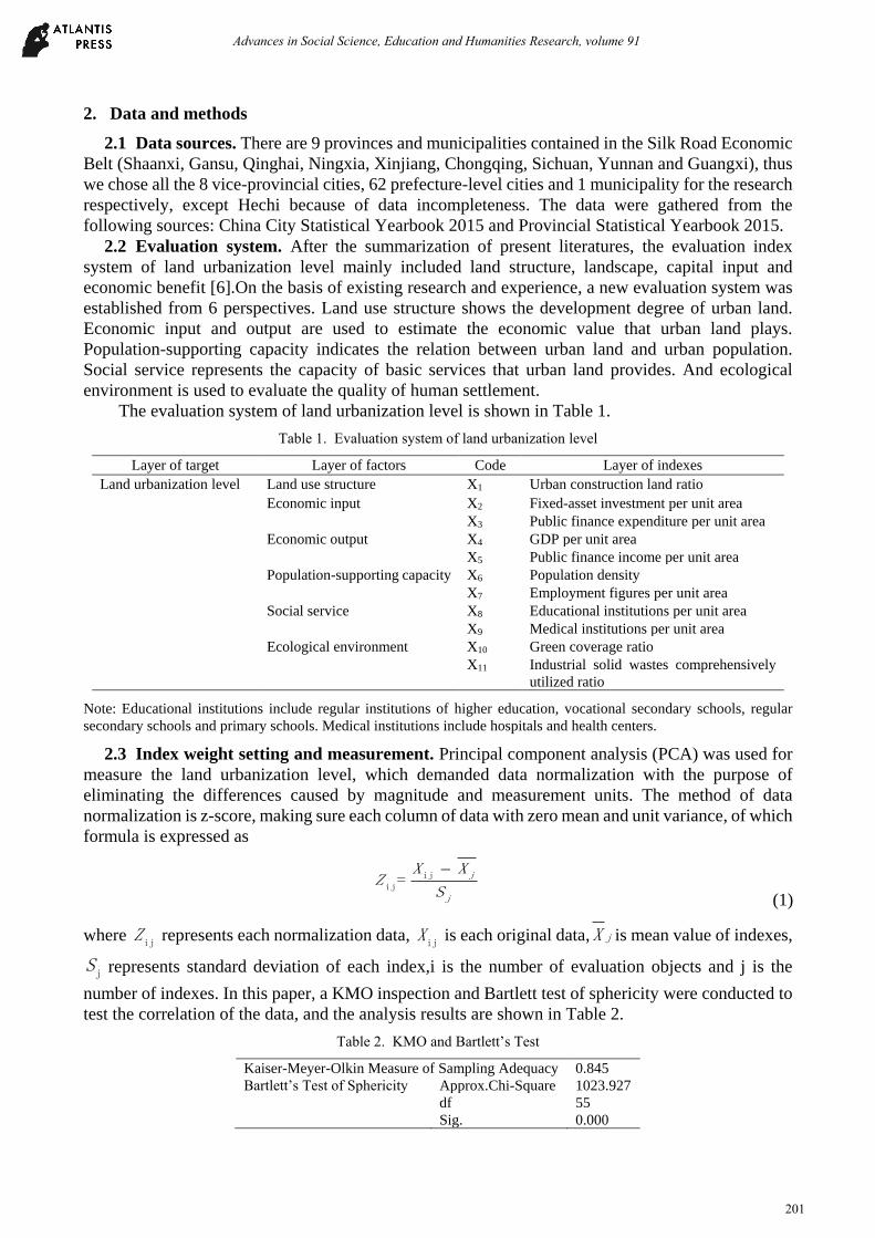
2.2 Evaluation system. After the summarization of present literatures, the evaluation index
system of land urbanization level mainly included land structure, landscape, capital input and
economic benefit [6].On the basis of existing research and experience, a new evaluation system was
established from 6 perspectives. Land use structure shows the development degree of urban land.
Economic input and output are used to estimate the economic value that urban land plays.
Population-supporting capacity indicates the relation between urban land and urban population.
Social service represents the capacity of basic services that urban land provides. And ecological
environment is used to evaluate the quality of human settlement.
The evaluation system of land urbanization level is shown in Table 1.
Table 1. Evaluation system of land urbanization level
Layer of target Layer of factors Code Layer of indexes
Land urbanization level Land use structure X1 Urban construction land ratio
Economic input X2 Fixed-asset investment per unit area
X3 Public finance expenditure per unit area
Economic output X4 GDP per unit area
X5 Public finance income per unit area
Population-supporting capacity X6 Population density
X7 Employment figures per unit area
Social service X8 Educational institutions per unit area
X9 Medical institutions per unit area
Ecological environment X10 Green coverage ratio
X11 Industrial solid wastes comprehensively
utilized ratio
Note: Educational institutions include regular institutions of higher education, vocational secondary schools, regular
secondary schools and primary schools. Medical institutions include hospitals and health centers.
2.3 Index weight setting and measurement. Principal component analysis (PCA) was used for
measure the land urbanization level, which demanded data normalization with the purpose of
eliminating the differences caused by magnitude and measurement units. The method of data
normalization is z-score, making sure each column of data with zero mean and unit variance, of which
formula is expressed as
ij
ij= j
j
X XZ
S
(1)
where ijZ represents each normalization data,
ijX is each original data, jX is mean value of indexes,
jS represents standard deviation of each index,i is the number of evaluation objects and j is the
number of indexes. In this paper, a KMO inspection and Bartlett test of sphericity were conducted to
test the correlation of the data, and the analysis results are shown in Table 2.
Table 2. KMO and Bartlett’s Test
Kaiser-Meyer-Olkin Measure of Sampling Adequacy 0.845
Bartlett’s Test of Sphericity Approx.Chi-Square 1023.927
df 55
Sig. 0.000
Advances in Social Science, Education and Humanities Research, volume 91
201
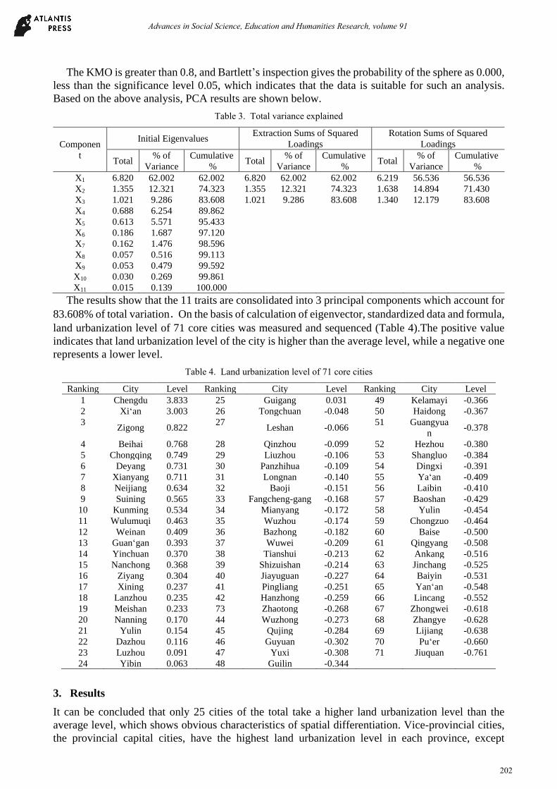
The KMO is greater than 0.8, and Bartlett’s inspection gives the probability of the sphere as 0.000,
less than the significance level 0.05, which indicates that the data is suitable for such an analysis.
Based on the above analysis, PCA results are shown below.
Table 3. Total variance explained
Componen
t
Initial Eigenvalues Extraction Sums of Squared
Loadings
Rotation Sums of Squared
Loadings
Total % of
Variance
Cumulative
% Total
% of
Variance
Cumulative
% Total
% of
Variance
Cumulative
%
X1 6.820 62.002 62.002 6.820 62.002 62.002 6.219 56.536 56.536
X2 1.355 12.321 74.323 1.355 12.321 74.323 1.638 14.894 71.430
X3 1.021 9.286 83.608 1.021 9.286 83.608 1.340 12.179 83.608
X4 0.688 6.254 89.862
X5 0.613 5.571 95.433
X6 0.186 1.687 97.120
X7 0.162 1.476 98.596
X8 0.057 0.516 99.113
X9 0.053 0.479 99.592
X10 0.030 0.269 99.861
X11 0.015 0.139 100.000
The results show that the 11 traits are consolidated into 3 principal components which account for
83.608% of total variation.On the basis of calculation of eigenvector, standardized data and formula,
land urbanization level of 71 core cities was measured and sequenced (Table 4).The positive value
indicates that land urbanization level of the city is higher than the average level, while a negative one
represents a lower level.
Table 4. Land urbanization level of 71 core cities
Ranking City Level Ranking City Level Ranking City Level
1 Chengdu 3.833 25 Guigang 0.031 49 Kelamayi -0.366
2 Xi‘an 3.003 26 Tongchuan -0.048 50 Haidong -0.367
3 Zigong 0.822
27 Leshan -0.066
51 Guangyua
n -0.378
4 Beihai 0.768 28 Qinzhou -0.099 52 Hezhou -0.380
5 Chongqing 0.749 29 Liuzhou -0.106 53 Shangluo -0.384
6 Deyang 0.731 30 Panzhihua -0.109 54 Dingxi -0.391
7 Xianyang 0.711 31 Longnan -0.140 55 Ya‘an -0.409
8 Neijiang 0.634 32 Baoji -0.151 56 Laibin -0.410
9 Suining 0.565 33 Fangcheng-gang -0.168 57 Baoshan -0.429
10 Kunming 0.534 34 Mianyang -0.172 58 Yulin -0.454
11 Wulumuqi 0.463 35 Wuzhou -0.174 59 Chongzuo -0.464
12 Weinan 0.409 36 Bazhong -0.182 60 Baise -0.500
13 Guan‘gan 0.393 37 Wuwei -0.209 61 Qingyang -0.508
14 Yinchuan 0.370 38 Tianshui -0.213 62 Ankang -0.516
15 Nanchong 0.368 39 Shizuishan -0.214 63 Jinchang -0.525
16 Ziyang 0.304 40 Jiayuguan -0.227 64 Baiyin -0.531
17 Xining 0.237 41 Pingliang -0.251 65 Yan‘an -0.548
18 Lanzhou 0.235 42 Hanzhong -0.259 66 Lincang -0.552
19 Meishan 0.233 73 Zhaotong -0.268 67 Zhongwei -0.618
20 Nanning 0.170 44 Wuzhong -0.273 68 Zhangye -0.628
21 Yulin 0.154 45 Qujing -0.284 69 Lijiang -0.638
22 Dazhou 0.116 46 Guyuan -0.302 70 Pu‘er -0.660
23 Luzhou 0.091 47 Yuxi -0.308 71 Jiuquan -0.761
24 Yibin 0.063 48 Guilin -0.344
3. Results
It can be concluded that only 25 cities of the total take a higher land urbanization level than the
average level, which shows obvious characteristics of spatial differentiation. Vice-provincial cities,
the provincial capital cities, have the highest land urbanization level in each province, except
Advances in Social Science, Education and Humanities Research, volume 91
202
Nanning. It’s not surprising to find this result, because funds, population, resources and technologies,
attracted by the provincial capital cities, effectively promote the land urbanization process.
Meanwhile, the land urbanization level of Chongqing municipality is higher than any other
provinces’ average level, and cities with a high level of land urbanization are centrally distributed in
such provinces as Sichuan, Shaanxi and Xinjiang, while other backward regions mainly locate in
Qinghai, Ningxia, Yunnan and Gansu. Through analysis, a significant spatial differentiation of land
urbanization level is found both in provincial scale and in urban scale in 2014, reflecting regional
development distinctions in economy, finance, industry, urbanization and land use.
4. Conclusions
To sum up, land urbanization is a significant aspect of urbanization and land use, playing an essential
role in the development of Silk Road Economic Belt. On the basis of existing research and experience,
land use structure, economic input, economic output, population-supporting capacity, social service
and ecological environment were considered the factors to evaluate land urbanization, and 11 specific
indexes were selected to measure the land urbanization level. Through establishing the evaluation
system, this paper evaluated the land urbanization level of core cities in the Silk Road Economic Belt,
using the cross-sectional data of 71 cities in 2014, and principal component analysis was employed as
the main research method. The results indicated the unbalanced development of land urbanization
among selected provinces, which needs further research and policy support.
To promote the function of Silk Road Economic Belt, the government’s primary task is to get to
grips with the land urbanization. First, the top design of land urbanization should be enhanced.
Depending on the diverse development situations, phased and targeted policies would take effect in
different regions, therefore, it’s an effective method to improve the land urbanization level and
eliminate the gap between developed and backward cities by establishing perfect policies and rules.
Second, the evaluation system of land urbanization level should be improved. Compared with
evaluation system of urbanization, evaluation system of land urbanization has not been paid enough
attention, leading to a lack of complete understanding and profound recognition about land
urbanization, which makes an objective and scientific evaluation system urgently needed. Third, the
cooperation among provinces and cities should be strengthened. Although the financial cooperation
has gained an initial scale and scientific cooperation in major projects has scored remarkable
achievements [7], achievement of intergovernmental cooperation has not come to arise, which is
supposed to maximize efficiency and drive improvements in land urbanization. Forth, the
relationship between exploitation and protection of resources should be well handled. Only by
reducing the adverse phenomena such as excessive occupation of cultivated land and waste of
construction land, can land urbanization in Silk Road Economic Belt achieve sustainable
development.
Despite the present results and proposals have been involved in this paper, land urbanization level
of core cities in the Silk Road Economic Belt remains to be further studied.
References
[1] Bai Y, Wang S. Deep Background and Geopolitical Strategy of Silk-road Economic Belt [J].
Reform, 2014(3):64-73. (in Chinese)
[2] Da-Dao L U, Yao S M. A SCIENTIFIC THOUGHT ABOUT URBANIZATION PROGRESS IN
CHINA [J]. Human Geography, 2007(4):1-5. (in Chinese)
[3] Li T. URBANIZATION OF LAND IN URBANIZATION PROCESS OF CHINA:BOON OR
BANE? [J]. City Planning Review, 2011, v.35;No.280(2):11-12. (in Chinese)
[4] Yang Y,Ma X,Wang C. THE SPATIAL-TEMPORAL DYNAMICS OF THE LAND
URBANIZATION LEVEL IN CHINA BASED ON NIGHTTIME LIGHT DATA [J]. Human
Geography, 2015(5):91-98. (in Chinese)
Advances in Social Science, Education and Humanities Research, volume 91
203
[5] Lin X, Wang Y, Wang S, et al. Spatial differences and driving forces of land urbanization in
China[J]. Journal of Geographical Sciences, 2015, 25(5):545-558.
[6] Ping LV, Tao Z, Zheng-Feng Z, et al. Construction and Application of Land Urbanization and
Corresponding Measurement Index System[J]. China Land Science, 2008, 22(8):24-31. (in
Chinese)
[7] Zhang Z, Pu Z. Conforming to the Trend at An Appropriate Time——My Thoughts on the
Building of the Silk Road Economic Belt[J]. International Understanding, 2013(4):6-8.
Advances in Social Science, Education and Humanities Research, volume 91
204