Embed Size (px)
Citation preview

Hoi
Pa
b
c
d
a
ARRA
KPLUFSE
I
caeae2uam
EN
(
0h
Land Use Policy 32 (2013) 230– 238
Contents lists available at SciVerse ScienceDirect
Land Use Policy
jou rn al h om epa ge: www.elsev ier .com/ locate / landusepol
ow are America’s private forests changing? An integrated assessmentf forest management, housing pressure, and urban developmentn alternate emissions scenarios
inki Mondala,∗, Brett J. Butlerb, David B. Kittredgea,c, Warren K. Moserd
University of Massachusetts–Amherst, Department of Environmental Conservation, 160 Holdsworth Way, Amherst, MA 01003, United StatesU.S. Forest Service, Northern Research Station, 160 Holdsworth Way, Amherst, MA 01003, United StatesHarvard Forest, Harvard University, Petersham, MA 01366, United StatesU.S. Forest Service, Northern Research Station, 1992 Folwell Avenue, St Paul, MN 55108, United States
r t i c l e i n f o
rticle history:eceived 2 May 2012eceived in revised form 16 October 2012ccepted 16 October 2012
eywords:rivate forestand userban–rural interfaceorest ownershipocio-economic contextmission scenario
a b s t r a c t
Private forests are a vital component of the natural ecosystem infrastructure of the United States, andprovide critical ecosystem services including clean air and water, energy, wildlife habitat, recreationalservices, and wood fiber. These forests have been subject to conversion to developed uses due to increas-ing population pressures. This study examines the changing patterns in the private forests across theurban–rural gradient in 36 states in the eastern United States. We combine observed forest manage-ment activities, housing pressure, and 50-year projections of development pressures under alternateIPCC emission scenarios (A1, A2, B1, and B2) to produce a forest pressures index for a total of 45,707 plotslocated on privately owned land. We find evidence of continued forest loss in suburban/urban regions,and imminent pressure on private forests in exurban regions, while forests in rural regions are foundto be relatively stable in next 50 years. Patterns of forest pressures differ depending on the sub-regions,which can be attributed to differing socio-ecological context of these sub-regions. Forest pressures also
differ depending on the alternate scenarios considered, as projected increases in impervious surfaces ishigher for the A1 and A2 scenarios as compared to the B1 and B2 scenarios. Land owners, often influencedby changing economic, demographic, and environmental trends, will play an important role in managinggoods and services provided by these private forests. While it remains challenging to model forest ownerattributes, socio-economic factors appear to be critical in shaping the future forested landscape in theUnited States.ntroduction
Land use change is a major contributor to global environmentalhange (Foley et al., 2005; Millennium Assessment, 2005). Manyssessments of climate and land use dynamics report their coupledffects on global environment, as decoupling of changing climatend land use issues is difficult (Millennium Assessment, 2005; Jetzt al., 2007; Brook et al., 2008; Lee and Jetz, 2008; Clavero et al.,011). Forests play an important role in this climate change–land-
se dynamic as they sequester carbon and help to reduce themount of carbon dioxide in the atmosphere. Approximately 200illion metric tons of carbon are sequestered by forests in the∗ Corresponding author. Present address: Columbia University, Department ofcology, Evolution and Environmental Biology, 1200 Amsterdam Avenue, New York,Y 10027, United States. Tel.: +1 212 854 9987; fax: +1 212 854 8188.
E-mail addresses: [email protected] (P. Mondal), [email protected]. Butler), [email protected] (D.B. Kittredge), [email protected] (W.K. Moser).
264-8377/$ – see front matter © 2012 Elsevier Ltd. All rights reserved.ttp://dx.doi.org/10.1016/j.landusepol.2012.10.014
© 2012 Elsevier Ltd. All rights reserved.
United States (U.S.) each year (Heath and Smith, 2004), offsettingapproximately 10% of current U.S. carbon emissions (Woodburyet al., 2007). While deforestation worldwide contributes 18% ofall carbon dioxide emissions (Stern, 2006), this number is likelyto change depending on future development patterns. To facili-tate further research in alternate global climate change scenarios,the Intergovernmental Panel on Climate Change (IPCC) has devel-oped the Special Report on Emissions Scenarios (SRES) with social,economic, and demographic storylines (Nakicenovic et al., 2000),which can be directly linked to global climate models. Since privateforests in the U.S. are collectively controlled by approximately 11million private owners (Butler, 2008), the maintenance and con-servation of these forests are critical in mitigating greenhouse gasemissions and global climate change.
Private forests comprise approximately 56% (approximately 171
million hectare) of the total forested land in the U.S. (Butler, 2008).These forests not only provide many critical ecosystem services,including timber, water, and recreational facilities, but are alsoimportant for at-risk species whose habitats are a patchwork of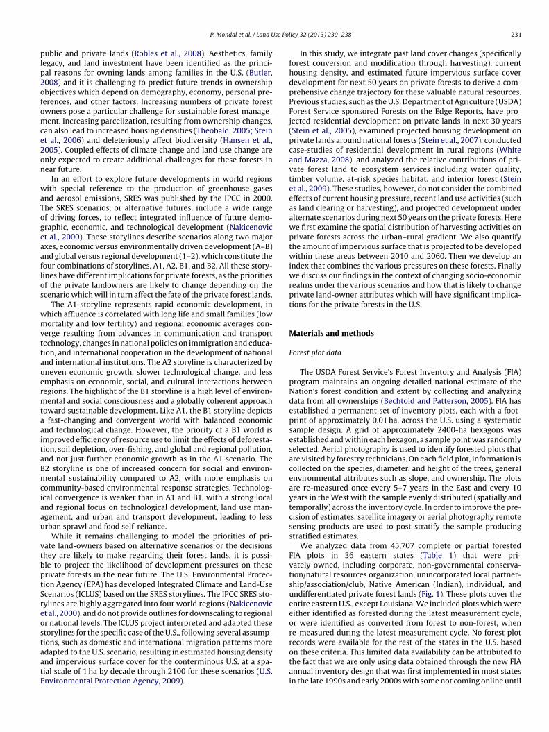
se Pol
plp2ofomce2on
waTogeaaflos
wmvttauermtaaitaBmciaau
vtbptSreostaatE
P. Mondal et al. / Land U
ublic and private lands (Robles et al., 2008). Aesthetics, familyegacy, and land investment have been identified as the princi-al reasons for owning lands among families in the U.S. (Butler,008) and it is challenging to predict future trends in ownershipbjectives which depend on demography, economy, personal pre-erences, and other factors. Increasing numbers of private forestwners pose a particular challenge for sustainable forest manage-ent. Increasing parcelization, resulting from ownership changes,
an also lead to increased housing densities (Theobald, 2005; Steint al., 2006) and deleteriously affect biodiversity (Hansen et al.,005). Coupled effects of climate change and land use change arenly expected to create additional challenges for these forests inear future.
In an effort to explore future developments in world regionsith special reference to the production of greenhouse gases
nd aerosol emissions, SRES was published by the IPCC in 2000.he SRES scenarios, or alternative futures, include a wide rangef driving forces, to reflect integrated influence of future demo-raphic, economic, and technological development (Nakicenovict al., 2000). These storylines describe scenarios along two majorxes, economic versus environmentally driven development (A–B)nd global versus regional development (1–2), which constitute theour combinations of storylines, A1, A2, B1, and B2. All these story-ines have different implications for private forests, as the prioritiesf the private landowners are likely to change depending on thecenario which will in turn affect the fate of the private forest lands.
The A1 storyline represents rapid economic development, inhich affluence is correlated with long life and small families (lowortality and low fertility) and regional economic averages con-
erge resulting from advances in communication and transportechnology, changes in national policies on immigration and educa-ion, and international cooperation in the development of nationalnd international institutions. The A2 storyline is characterized byneven economic growth, slower technological change, and lessmphasis on economic, social, and cultural interactions betweenegions. The highlight of the B1 storyline is a high level of environ-ental and social consciousness and a globally coherent approach
oward sustainable development. Like A1, the B1 storyline depicts fast-changing and convergent world with balanced economicnd technological change. However, the priority of a B1 world ismproved efficiency of resource use to limit the effects of deforesta-ion, soil depletion, over-fishing, and global and regional pollution,nd not just further economic growth as in the A1 scenario. The2 storyline is one of increased concern for social and environ-ental sustainability compared to A2, with more emphasis on
ommunity-based environmental response strategies. Technolog-cal convergence is weaker than in A1 and B1, with a strong localnd regional focus on technological development, land use man-gement, and urban and transport development, leading to lessrban sprawl and food self-reliance.
While it remains challenging to model the priorities of pri-ate land-owners based on alternative scenarios or the decisionshey are likely to make regarding their forest lands, it is possi-le to project the likelihood of development pressures on theserivate forests in the near future. The U.S. Environmental Protec-ion Agency (EPA) has developed Integrated Climate and Land-Usecenarios (ICLUS) based on the SRES storylines. The IPCC SRES sto-ylines are highly aggregated into four world regions (Nakicenovict al., 2000), and do not provide outlines for downscaling to regionalr national levels. The ICLUS project interpreted and adapted thesetorylines for the specific case of the U.S., following several assump-ions, such as domestic and international migration patterns more
dapted to the U.S. scenario, resulting in estimated housing densitynd impervious surface cover for the conterminous U.S. at a spa-ial scale of 1 ha by decade through 2100 for these scenarios (U.S.nvironmental Protection Agency, 2009).icy 32 (2013) 230– 238 231
In this study, we integrate past land cover changes (specificallyforest conversion and modification through harvesting), currenthousing density, and estimated future impervious surface coverdevelopment for next 50 years on private forests to derive a com-prehensive change trajectory for these valuable natural resources.Previous studies, such as the U.S. Department of Agriculture (USDA)Forest Service-sponsored Forests on the Edge Reports, have pro-jected residential development on private lands in next 30 years(Stein et al., 2005), examined projected housing development onprivate lands around national forests (Stein et al., 2007), conductedcase-studies of residential development in rural regions (Whiteand Mazza, 2008), and analyzed the relative contributions of pri-vate forest land to ecosystem services including water quality,timber volume, at-risk species habitat, and interior forest (Steinet al., 2009). These studies, however, do not consider the combinedeffects of current housing pressure, recent land use activities (suchas land clearing or harvesting), and projected development underalternate scenarios during next 50 years on the private forests. Herewe first examine the spatial distribution of harvesting activities onprivate forests across the urban–rural gradient. We also quantifythe amount of impervious surface that is projected to be developedwithin these areas between 2010 and 2060. Then we develop anindex that combines the various pressures on these forests. Finallywe discuss our findings in the context of changing socio-economicrealms under the various scenarios and how that is likely to changeprivate land-owner attributes which will have significant implica-tions for the private forests in the U.S.
Materials and methods
Forest plot data
The USDA Forest Service’s Forest Inventory and Analysis (FIA)program maintains an ongoing detailed national estimate of theNation’s forest condition and extent by collecting and analyzingdata from all ownerships (Bechtold and Patterson, 2005). FIA hasestablished a permanent set of inventory plots, each with a foot-print of approximately 0.01 ha, across the U.S. using a systematicsample design. A grid of approximately 2400-ha hexagons wasestablished and within each hexagon, a sample point was randomlyselected. Aerial photography is used to identify forested plots thatare visited by forestry technicians. On each field plot, information iscollected on the species, diameter, and height of the trees, generalenvironmental attributes such as slope, and ownership. The plotsare re-measured once every 5–7 years in the East and every 10years in the West with the sample evenly distributed (spatially andtemporally) across the inventory cycle. In order to improve the pre-cision of estimates, satellite imagery or aerial photography remotesensing products are used to post-stratify the sample producingstratified estimates.
We analyzed data from 45,707 complete or partial forestedFIA plots in 36 eastern states (Table 1) that were pri-vately owned, including corporate, non-governmental conserva-tion/natural resources organization, unincorporated local partner-ship/association/club, Native American (Indian), individual, andundifferentiated private forest lands (Fig. 1). These plots cover theentire eastern U.S., except Louisiana. We included plots which wereeither identified as forested during the latest measurement cycle,or were identified as converted from forest to non-forest, whenre-measured during the latest measurement cycle. No forest plotrecords were available for the rest of the states in the U.S. based
on these criteria. This limited data availability can be attributed tothe fact that we are only using data obtained through the new FIAannual inventory design that was first implemented in most statesin the late 1990s and early 2000s with some not coming online until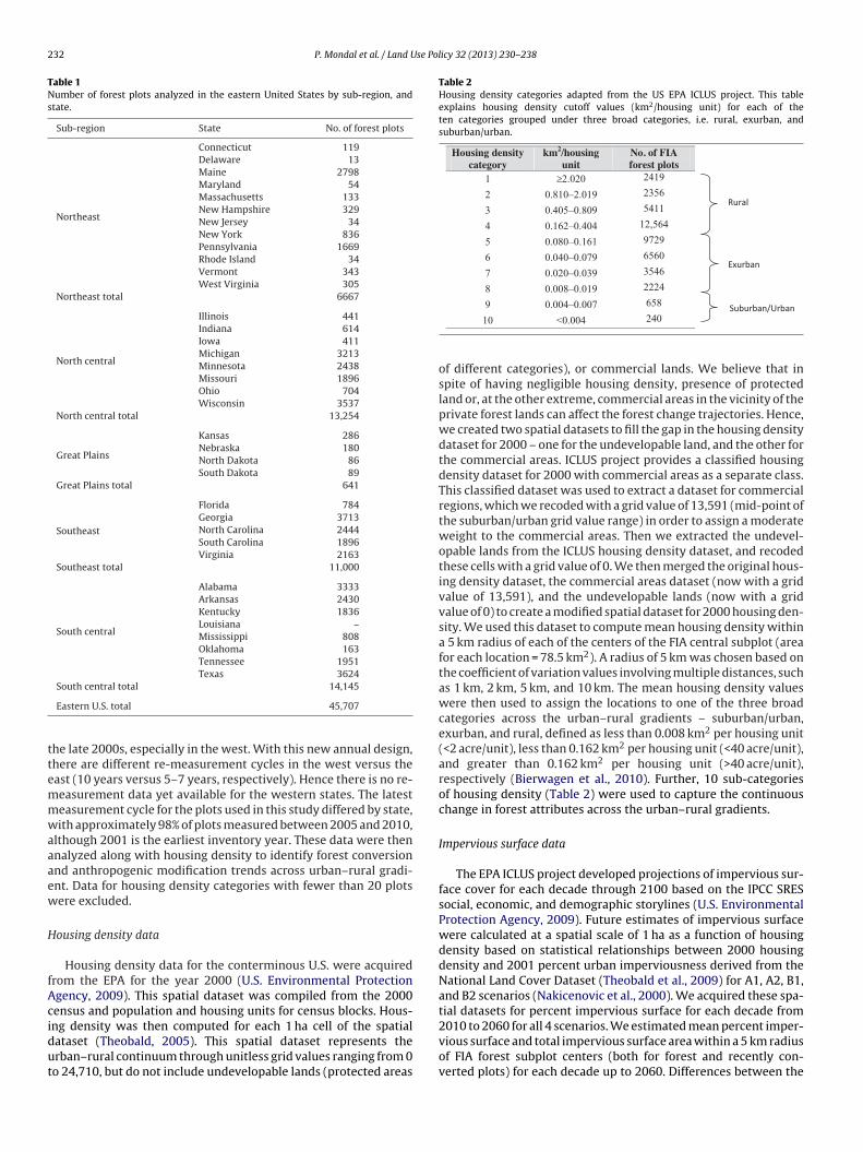
232 P. Mondal et al. / Land Use Policy 32 (2013) 230– 238
Table 1Number of forest plots analyzed in the eastern United States by sub-region, andstate.
Sub-region State No. of forest plots
Northeast
Connecticut 119Delaware 13Maine 2798Maryland 54Massachusetts 133New Hampshire 329New Jersey 34New York 836Pennsylvania 1669Rhode Island 34Vermont 343West Virginia 305
Northeast total 6667
North central
Illinois 441Indiana 614Iowa 411Michigan 3213Minnesota 2438Missouri 1896Ohio 704Wisconsin 3537
North central total 13,254
Great Plains
Kansas 286Nebraska 180North Dakota 86South Dakota 89
Great Plains total 641
Southeast
Florida 784Georgia 3713North Carolina 2444South Carolina 1896Virginia 2163
Southeast total 11,000
South central
Alabama 3333Arkansas 2430Kentucky 1836Louisiana –Mississippi 808Oklahoma 163Tennessee 1951Texas 3624
ttemmwaaaew
H
fAcidut
Table 2Housing density categories adapted from the US EPA ICLUS project. This tableexplains housing density cutoff values (km2/housing unit) for each of theten categories grouped under three broad categories, i.e. rural, exurban, andsuburban/urban.
Housing density category
km2/housingunit
No. of FIA forest plots
1 ≥2.020 2419
2 0.810–2.019 2356
3 0.405–0.809 5411
4 0.162–0.404 12,564
5 0.080–0.161 9729
6 0.040–0.079 6560
7 0.020–0.039 3546
8 0.008–0.019 2224
658
South central total 14,145
Eastern U.S. total 45,707
he late 2000s, especially in the west. With this new annual design,here are different re-measurement cycles in the west versus theast (10 years versus 5–7 years, respectively). Hence there is no re-easurement data yet available for the western states. The latesteasurement cycle for the plots used in this study differed by state,ith approximately 98% of plots measured between 2005 and 2010,
lthough 2001 is the earliest inventory year. These data were thennalyzed along with housing density to identify forest conversionnd anthropogenic modification trends across urban–rural gradi-nt. Data for housing density categories with fewer than 20 plotsere excluded.
ousing density data
Housing density data for the conterminous U.S. were acquiredrom the EPA for the year 2000 (U.S. Environmental Protectiongency, 2009). This spatial dataset was compiled from the 2000ensus and population and housing units for census blocks. Hous-
ng density was then computed for each 1 ha cell of the spatialataset (Theobald, 2005). This spatial dataset represents therban–rural continuum through unitless grid values ranging from 0o 24,710, but do not include undevelopable lands (protected areas9 0.004–0.007
10 <0.004 240
of different categories), or commercial lands. We believe that inspite of having negligible housing density, presence of protectedland or, at the other extreme, commercial areas in the vicinity of theprivate forest lands can affect the forest change trajectories. Hence,we created two spatial datasets to fill the gap in the housing densitydataset for 2000 – one for the undevelopable land, and the other forthe commercial areas. ICLUS project provides a classified housingdensity dataset for 2000 with commercial areas as a separate class.This classified dataset was used to extract a dataset for commercialregions, which we recoded with a grid value of 13,591 (mid-point ofthe suburban/urban grid value range) in order to assign a moderateweight to the commercial areas. Then we extracted the undevel-opable lands from the ICLUS housing density dataset, and recodedthese cells with a grid value of 0. We then merged the original hous-ing density dataset, the commercial areas dataset (now with a gridvalue of 13,591), and the undevelopable lands (now with a gridvalue of 0) to create a modified spatial dataset for 2000 housing den-sity. We used this dataset to compute mean housing density withina 5 km radius of each of the centers of the FIA central subplot (areafor each location = 78.5 km2). A radius of 5 km was chosen based onthe coefficient of variation values involving multiple distances, suchas 1 km, 2 km, 5 km, and 10 km. The mean housing density valueswere then used to assign the locations to one of the three broadcategories across the urban–rural gradients – suburban/urban,exurban, and rural, defined as less than 0.008 km2 per housing unit(<2 acre/unit), less than 0.162 km2 per housing unit (<40 acre/unit),and greater than 0.162 km2 per housing unit (>40 acre/unit),respectively (Bierwagen et al., 2010). Further, 10 sub-categoriesof housing density (Table 2) were used to capture the continuouschange in forest attributes across the urban–rural gradients.
Impervious surface data
The EPA ICLUS project developed projections of impervious sur-face cover for each decade through 2100 based on the IPCC SRESsocial, economic, and demographic storylines (U.S. EnvironmentalProtection Agency, 2009). Future estimates of impervious surfacewere calculated at a spatial scale of 1 ha as a function of housingdensity based on statistical relationships between 2000 housingdensity and 2001 percent urban imperviousness derived from theNational Land Cover Dataset (Theobald et al., 2009) for A1, A2, B1,and B2 scenarios (Nakicenovic et al., 2000). We acquired these spa-tial datasets for percent impervious surface for each decade from
2010 to 2060 for all 4 scenarios. We estimated mean percent imper-vious surface and total impervious surface area within a 5 km radiusof FIA forest subplot centers (both for forest and recently con-verted plots) for each decade up to 2060. Differences between the
P. Mondal et al. / Land Use Policy 32 (2013) 230– 238 233
F al., 20t
peiieit
F
cihiiavitpfharbciwihip5
ig. 1. Spatial distribution of private forests across the U.S. (data source: Nelson et
he eastern U.S.
ercent impervious cover for two dates were then calculated forach location. So, for example, the difference between the percentmpervious cover for 2010 and 2060 for a particular location wouldndicate projected percent development within 5 km surroundingach of the FIA forest plot center during the next 50 years. Total arean each location projected to develop under different scenarios washen calculated.
orest pressures index
We first developed three categorical indices – one each for:hanging land use/cover, 2000 housing density, and change inmpervious surface cover between 2010 and 2060. All these indicesave lower values for no/negligible change/projected change, with
ncreasing values for higher level of changes. The land use/coverndex has a value of 0 for the forest plots that did not undergony harvesting activities during the latest measurement cycle; aalue of 1 was assigned to modified forest plots where harvest-ng has been recorded (we considered only sawtimber harvestingo exclude other low-intensity forest products removal), but thelots remained as forest; a value of 2 was assigned to convertedorest plots, where a forest to non-forest conversion occurred. Theousing density index has a value of 0, 1, or 2 when the forest plotsre located within the rural, exurban, and suburban/urban regionespectively, as explained in Table 2. The impervious surface indexuilds upon the cumulative change in percent impervious surfaceover between 2010 and 2060. If there is no change predicted, thempervious surface index has a value of 0. A value of 1 is assigned
hen the increase in impervious surface cover within 5 km vicinitys ≤1%. A value of 2 is assigned to the plots which are projected to
ave >1% but ≤5% increase in impervious cover within 5 km vicin-ty; and a maximum value of 3 is assigned to the plots which areredicted to have ≥5% increase in impervious surface cover within
km vicinity during next 50 years. Class break values were selected
10), and boundaries of five sub-regions included in this study covering 36 states in
based on sample distribution to ensure sufficient representationin each of the four categories (i.e. at least 20 plots in each of thecategories).
We then developed a forest pressures index (FPI), to representthe cumulative effect of forest management activities and result-ing changes in land use/cover, current housing density, and futuredevelopment potential on the FIA private forest plots and theirsurroundings. FPI is an additive measure of the individual indicesdescribed above, where all the components carry equal weight (seeEq. (1)). It should be noted, however, that the impervious surfacearea is somewhat related to housing density, resulting in hous-ing density index with relatively higher weight than the other twoindices.
FPI =(
land use/cover index + housing density index
+ impervious surface index)
(1)
FPI has a range of 0–7. A lower FPI value indicates forest plots inrural regions which are likely to undergo negligible/no change interms of development in next 50 years. A higher FPI value indicatesforest plots located in either exurban or suburban/urban regions,hence already under pressure from potential development, or plotswhich have already been converted to non-forest, and have higherchances of development in next 50 years.
Results
Forest conversion and modification
FIA data for harvesting (forest modification) and land clear-ing (forest conversion), when reported against current housingdensity, exhibit varied patterns across the sub-regions (Fig. 2).

234 P. Mondal et al. / Land Use Policy 32 (2013) 230– 238
% p
lot
0
5
10
15
20
25
30
0 2 4 6 8 10
% Plot harvested
% Plot cleared
Housing den sit y cate gory
% p
lot
0
5
10
15
20
25
30
0 2 4 6 8 10
% Plo t harvested
% Plo t clea red
% p
lot
0
5
10
15
20
25
30
0 2 4 6 8 10
% Plot harvested
% Plot cleared
% p
lot
0
5
10
15
20
25
30
0 2 4 6 8 10
% Plo t harvested
% Plo t clea red
(a) NortheastSample si ze=6,6 67
(e) South CentralSample si ze=14,145
(b) North CentralSample si ze=13,254
(d) SoutheastSample si ze=11,000
% p
lot
0
5
10
15
20
25
30
0 2 4 6 8 10
% Plo t harvested
% Plo t clea red
(c) Great PlainsSample si ze=641
Housing den sit y cate gory
Housing den sit y cate gory
Housing den sit y cate gory
Housing den sit y cate gory
F t in fi1 s harv
Todmff
spl(emisihh1dinihpUfa
ig. 2. Trends in sawtimber harvesting activities across the urban–rural gradien0 = suburban/urban). Y-axis and legend refer to fraction of number of plots that wa
he suburban/urban housing density category (Table 2) has fewerbservations for all of these sub-regions as non-forest plots areominant in this category. These graphs corroborate our argu-ent that private forests in exurban regions are at higher risk
or conversion than those in rural regions, whereas rural privateorests are more likely to be modified through harvesting.
Forest modification through harvesting in the northeasternub-region is more frequent within the rural categories (Fig. 2a),robably due to rural Maine with a lot of industrial forest
and (Table 1). Harvesting activities in this sub-region are stable15–17%) within rural housing category, then decreases to 10% inxurban areas with lowest housing density, followed by an inter-ittent increase to 13%, and then steady decrease to 4% with
ncreasing housing density. Unlike the northeast, the north centralub-region exhibits an almost steady decrease from 10% harvest-ng in the rural regions to no detectable harvesting in the highestousing density category (Fig. 2b). The southeastern sub-regionas fewer than 20 forest plots in its most rural region (category: Table 2), hence was not reported. This sub-region exhibits aecreasing trend from 17% to 3% of the plots harvested with increas-
ng housing density (Fig. 2d). The south central sub-region, like theorth central, shows a decreasing trend in harvesting with increas-
ng housing density (Fig. 2e). Harvesting proportion, however, is theighest in this sub-region, ranging between 29% and 4%. Harvesting
roportion in the Great Plains ranges between 1% and 7% (Fig. 2c).nlike other sub-regions, the pattern is not clear, possibly due toewer plots in this sub-region (Table 1), and harvesting propensityppears to increase with housing density in this sub-region.
ve sub-regions in the eastern U.S. by housing density category (1 = most rural,ested or cleared.
We expected to see more conversion in exurban and subur-ban/urban areas, as private forests are subject to more pressureat the edges of growing towns and cities. We found supportingevidence in our study which shows that a majority of therural (and lower ends of exurban) housing density categoriesfor three out of five sub-regions witnessed forest conversion ofless than 5% of the plots in each of these housing categorieswhen re-measured during the latest measurement cycle (Fig. 2).These converted plots will most likely contribute toward therural/exurban–urban shifts as suggested by previous studies (Steinet al., 2005), or agricultural shifts in the Great Plains. Withoutany exception though, conversion took place in suburban/urbanareas or exurban areas with high housing density, probably asa result of urban sprawl, and higher commercial gains associ-ated with forest to non-forest conversion. In the southeast andsouth central sub-regions, for example, conversions were recordedin as high as 16% of the forest plots measured in the mostsuburban/urban category (housing categories 9 and 10). North-ern and southern sub-regions show similar trends with highestconversion rates in the housing density category 10 (Table 2),and varying degree of increasing conversion rates (Fig. 2a,b andd,e). The conversion scenario in the Great Plains differs fromboth these groups (Fig. 2c), as most plots were converted inhousing density categories 3 and 4 (Table 2). Since compar-
atively fewer records were found for category 7 onwards, itis difficult to confirm whether this trend is distinctive of thisregion or due to the absence of enough forest plots in thissub-region.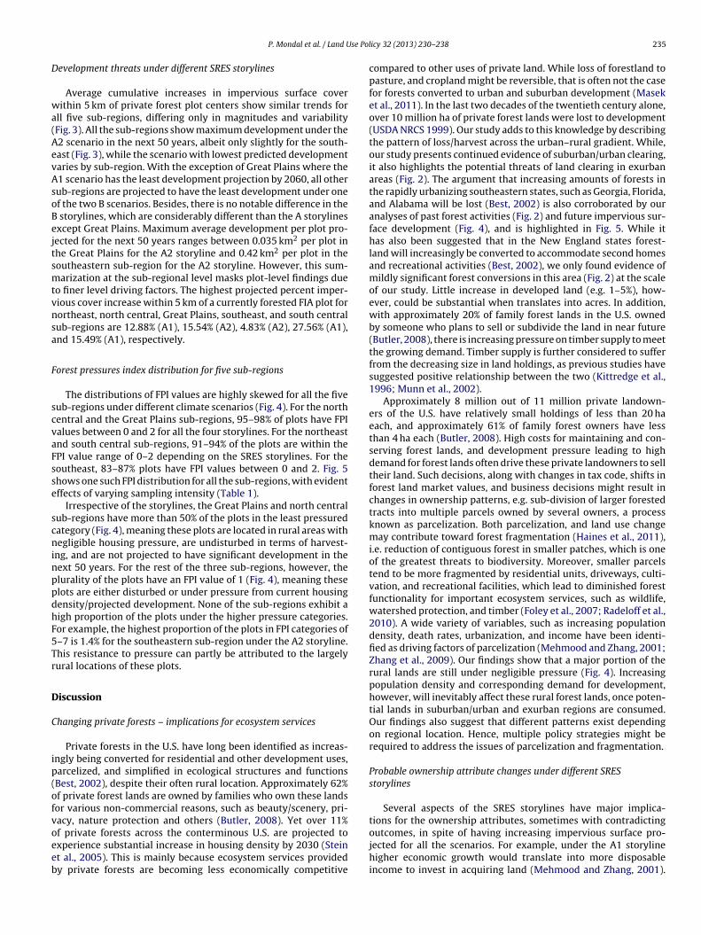
se Pol
D
wa(AevAsoBejtsmtvnsa
F
scvaFsse
scninppdhF5Tr
D
C
ip(ofvoeeb
P. Mondal et al. / Land U
evelopment threats under different SRES storylines
Average cumulative increases in impervious surface coverithin 5 km of private forest plot centers show similar trends for
ll five sub-regions, differing only in magnitudes and variabilityFig. 3). All the sub-regions show maximum development under the2 scenario in the next 50 years, albeit only slightly for the south-ast (Fig. 3), while the scenario with lowest predicted developmentaries by sub-region. With the exception of Great Plains where the1 scenario has the least development projection by 2060, all otherub-regions are projected to have the least development under onef the two B scenarios. Besides, there is no notable difference in the
storylines, which are considerably different than the A storylinesxcept Great Plains. Maximum average development per plot pro-ected for the next 50 years ranges between 0.035 km2 per plot inhe Great Plains for the A2 storyline and 0.42 km2 per plot in theoutheastern sub-region for the A2 storyline. However, this sum-arization at the sub-regional level masks plot-level findings due
o finer level driving factors. The highest projected percent imper-ious cover increase within 5 km of a currently forested FIA plot forortheast, north central, Great Plains, southeast, and south centralub-regions are 12.88% (A1), 15.54% (A2), 4.83% (A2), 27.56% (A1),nd 15.49% (A1), respectively.
orest pressures index distribution for five sub-regions
The distributions of FPI values are highly skewed for all the fiveub-regions under different climate scenarios (Fig. 4). For the northentral and the Great Plains sub-regions, 95–98% of plots have FPIalues between 0 and 2 for all the four storylines. For the northeastnd south central sub-regions, 91–94% of the plots are within thePI value range of 0–2 depending on the SRES storylines. For theoutheast, 83–87% plots have FPI values between 0 and 2. Fig. 5hows one such FPI distribution for all the sub-regions, with evidentffects of varying sampling intensity (Table 1).
Irrespective of the storylines, the Great Plains and north centralub-regions have more than 50% of the plots in the least pressuredategory (Fig. 4), meaning these plots are located in rural areas withegligible housing pressure, are undisturbed in terms of harvest-
ng, and are not projected to have significant development in theext 50 years. For the rest of the three sub-regions, however, thelurality of the plots have an FPI value of 1 (Fig. 4), meaning theselots are either disturbed or under pressure from current housingensity/projected development. None of the sub-regions exhibit aigh proportion of the plots under the higher pressure categories.or example, the highest proportion of the plots in FPI categories of–7 is 1.4% for the southeastern sub-region under the A2 storyline.his resistance to pressure can partly be attributed to the largelyural locations of these plots.
iscussion
hanging private forests – implications for ecosystem services
Private forests in the U.S. have long been identified as increas-ngly being converted for residential and other development uses,arcelized, and simplified in ecological structures and functionsBest, 2002), despite their often rural location. Approximately 62%f private forest lands are owned by families who own these landsor various non-commercial reasons, such as beauty/scenery, pri-acy, nature protection and others (Butler, 2008). Yet over 11%
f private forests across the conterminous U.S. are projected toxperience substantial increase in housing density by 2030 (Steint al., 2005). This is mainly because ecosystem services providedy private forests are becoming less economically competitiveicy 32 (2013) 230– 238 235
compared to other uses of private land. While loss of forestland topasture, and cropland might be reversible, that is often not the casefor forests converted to urban and suburban development (Maseket al., 2011). In the last two decades of the twentieth century alone,over 10 million ha of private forest lands were lost to development(USDA NRCS 1999). Our study adds to this knowledge by describingthe pattern of loss/harvest across the urban–rural gradient. While,our study presents continued evidence of suburban/urban clearing,it also highlights the potential threats of land clearing in exurbanareas (Fig. 2). The argument that increasing amounts of forests inthe rapidly urbanizing southeastern states, such as Georgia, Florida,and Alabama will be lost (Best, 2002) is also corroborated by ouranalyses of past forest activities (Fig. 2) and future impervious sur-face development (Fig. 4), and is highlighted in Fig. 5. While ithas also been suggested that in the New England states forest-land will increasingly be converted to accommodate second homesand recreational activities (Best, 2002), we only found evidence ofmildly significant forest conversions in this area (Fig. 2) at the scaleof our study. Little increase in developed land (e.g. 1–5%), how-ever, could be substantial when translates into acres. In addition,with approximately 20% of family forest lands in the U.S. ownedby someone who plans to sell or subdivide the land in near future(Butler, 2008), there is increasing pressure on timber supply to meetthe growing demand. Timber supply is further considered to sufferfrom the decreasing size in land holdings, as previous studies havesuggested positive relationship between the two (Kittredge et al.,1996; Munn et al., 2002).
Approximately 8 million out of 11 million private landown-ers of the U.S. have relatively small holdings of less than 20 haeach, and approximately 61% of family forest owners have lessthan 4 ha each (Butler, 2008). High costs for maintaining and con-serving forest lands, and development pressure leading to highdemand for forest lands often drive these private landowners to selltheir land. Such decisions, along with changes in tax code, shifts inforest land market values, and business decisions might result inchanges in ownership patterns, e.g. sub-division of larger forestedtracts into multiple parcels owned by several owners, a processknown as parcelization. Both parcelization, and land use changemay contribute toward forest fragmentation (Haines et al., 2011),i.e. reduction of contiguous forest in smaller patches, which is oneof the greatest threats to biodiversity. Moreover, smaller parcelstend to be more fragmented by residential units, driveways, culti-vation, and recreational facilities, which lead to diminished forestfunctionality for important ecosystem services, such as wildlife,watershed protection, and timber (Foley et al., 2007; Radeloff et al.,2010). A wide variety of variables, such as increasing populationdensity, death rates, urbanization, and income have been identi-fied as driving factors of parcelization (Mehmood and Zhang, 2001;Zhang et al., 2009). Our findings show that a major portion of therural lands are still under negligible pressure (Fig. 4). Increasingpopulation density and corresponding demand for development,however, will inevitably affect these rural forest lands, once poten-tial lands in suburban/urban and exurban regions are consumed.Our findings also suggest that different patterns exist dependingon regional location. Hence, multiple policy strategies might berequired to address the issues of parcelization and fragmentation.
Probable ownership attribute changes under different SRESstorylines
Several aspects of the SRES storylines have major implica-tions for the ownership attributes, sometimes with contradicting
outcomes, in spite of having increasing impervious surface pro-jected for all the scenarios. For example, under the A1 storylinehigher economic growth would translate into more disposableincome to invest in acquiring land (Mehmood and Zhang, 2001).
236 P. Mondal et al. / Land Use Policy 32 (2013) 230– 238
0
0.05
0.1
0.15
0.2
0.25
2010 2020 2030 2040 2050 2060
A1
A2
B1
B2
Impe
rvio
us s
urfa
ce a
rea
(sq.
km
.)
0
0.02
0.04
0.06
0.08
0.1
2010 2020 2030 2040 2050 2060
A1
A2
B1
B2
Impe
rvio
us s
urfa
ce a
rea
(sq.
km
.)
0.000.050.100.150.200.250.300.350.400.45
2010 2020 2030 2040 2050 2060
A1
A2
B1
B2
Impe
rvio
us s
urfa
ce a
rea
(sq.
km
.)
0.000.020.040.060.080.100.120.140.160.18
2010 2020 2030 2040 2050 2060
A1
A2
B1
B2
Impe
rvio
us s
urfa
ce a
rea
(sq.
km
.) (e) South Central(d) Southeast
(b) North Central(a) Northe ast
0.00
0.01
0.02
0.03
0.04
0.05
2010 2020 2030 2040 2050 2060
A1
A2
B1
B2
Impe
rvio
us s
urfa
ce a
rea
(sq.
km
.)(c) Great Plains
F s meab
H(flsitsct
sehttaufIraat
bsfh
ig. 3. Projected average changes in cumulative impervious surface cover per plot aetween 2010 and 2060 by SRES storylines (A1, A2, B1, and B2).
ypothetically, with increasing demand for second homes, desireand ability) to live in a rural setting, and/or an investment, moreamilies/individuals would have a piece of rural land ultimatelyeading to parcelization. Under the same storyline, shifts in familytructures and low fertility would lead to fewer heirs in the future,.e. fewer decision-makers – probably leading to less parceliza-ion. Overall, these circumstances probably would give rise toteady/increased forest loss/conversion, and division/sale of lands,ompared to the status quo of today. Due to high domestic migra-ion, number of absentee landowners would probably increase.
Slower economic convergence between regions under the A2toryline might translate into a slower rate of sale of family for-st lands, yet impervious surface development is projected to beighest under this storyline. Since A2 represents a world with con-inued economic development, more forest lands can be expectedo be developed to accommodate increased primary residences,long with second homes, and associated development. This willltimately increase the number of decision-makers, making theorest lands more vulnerable to economy and private preferences.n a slow economy, older owners would hypothetically have moreeliance on land for income, due to inadequate financial planningnd resources for income. This will translate to more parcelization,s the families would be selling off pieces of land, while retaininghe core of ownership.
Both B1 and B2 storylines emphasize environmental sustaina-
ility, only differing in the rate of economic development. In thesecenarios, the information-oriented economy increases demandor specialized labor pools, which in turn will increase number ofigh-paying jobs in urban centers. In addition, increased focus onsured in and around private plots (n = 45,707) in five sub-regions in the eastern U.S.
sustainability would result in subsidy reduction for developmentin rural regions. These factors, combined with minimized domes-tic migration, would lead to less interest in rural lands. With lessfinancial benefits to subdivide and sell rural lands, land ownershipwould be more stable in rural areas, whereas more forest lands areexpected to convert into residential areas in exurban regions toaccommodate the suburban/urban shift.
Sustainable forestry – what’s in store for future?
The relative stability in the area of total forestland in the U.S.in the last century can be attributed to reforestation resulting fromagricultural abandonment (Birdsey and Lewis, 2003), in spite of sig-nificant forest loss to other, primarily developed, land uses (Smithet al., 2009). Annual removals through harvesting, however, havewitnessed an approximate 10% increase between 1976 and 2006(Smith et al., 2009). In addition, there has been a significant shiftin harvesting by owner class. Removals from national forests havebeen reduced to approximately 15% of the level in 1976 with a cor-responding increase in private lands harvest, resulting in a shift intimber production from the West to the South (Masek et al., 2011).While shifts in public policy have reduced rates of harvesting onfederal lands (Healey et al., 2008), private timberlands are now fac-ing even more pressure to compensate for these reduced harvestingrates. However, smaller parcel sizes (<10 acres) controlled by the
majority (61%) of the family forest owners, who own approximately62% of private forests (Butler, 2008), may be deemed inadequatefor sustainable forestry (Kittredge et al., 1996; Munn et al., 2002).Sustainable commercial forestry is also likely to be affected by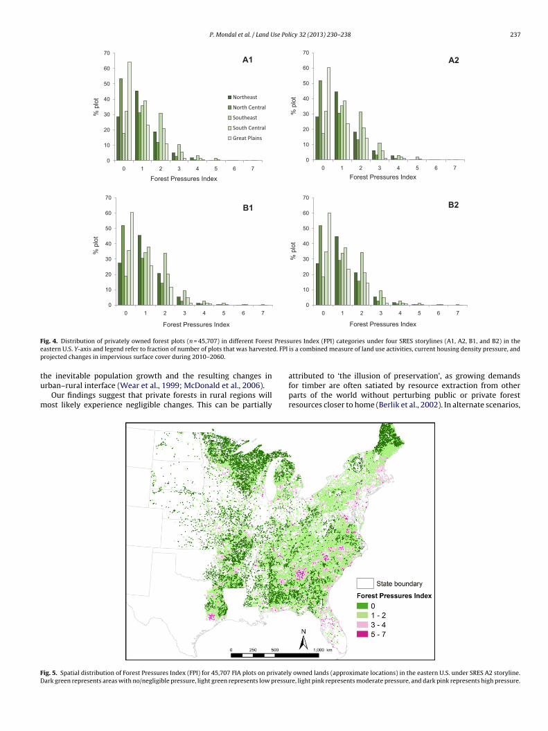
P. Mondal et al. / Land Use Policy 32 (2013) 230– 238 237
0
10
20
30
40
50
60
70
0 1 2 3 4 5 6 7
Northeast
North Central
Southea st
South Ce ntral
Great Plains
0
10
20
30
40
50
60
70
0 1 2 3 4 5 6 7
0
10
20
30
40
50
60
70
0 1 2 3 4 5 6 70
10
20
30
40
50
60
70
0 1 2 3 4 5 6 7
A1 A2
B1 B2
Forest Pressures Index
Forest Pressures Index
Forest Pressures Index
Forest Pressures Index
% p
lot
% p
lot
% p
lot
% p
lot
F Presse d. FPI
p
tu
m
FD
ig. 4. Distribution of privately owned forest plots (n = 45,707) in different Forestastern U.S. Y-axis and legend refer to fraction of number of plots that was harvesterojected changes in impervious surface cover during 2010–2060.
he inevitable population growth and the resulting changes inrban–rural interface (Wear et al., 1999; McDonald et al., 2006).
Our findings suggest that private forests in rural regions willost likely experience negligible changes. This can be partially
ig. 5. Spatial distribution of Forest Pressures Index (FPI) for 45,707 FIA plots on privatelyark green represents areas with no/negligible pressure, light green represents low pressu
ures Index (FPI) categories under four SRES storylines (A1, A2, B1, and B2) in theis a combined measure of land use activities, current housing density pressure, and
attributed to ‘the illusion of preservation’, as growing demandsfor timber are often satiated by resource extraction from otherparts of the world without perturbing public or private forestresources closer to home (Berlik et al., 2002). In alternate scenarios,
owned lands (approximate locations) in the eastern U.S. under SRES A2 storyline.re, light pink represents moderate pressure, and dark pink represents high pressure.
2 se Pol
hgttbicrist
A
NfAsSpd
R
B
B
B
B
B
B
B
C
F
F
H
H
H
H
J
K
38 P. Mondal et al. / Land U
owever, the nature-society dynamics might as well change withrowing environmental awareness, changing demands, advancingechnology, and international trade. Sustainability will also be con-rolled by the way owners adapt to the biophysical changes causedy climate change, such as changing patterns of drought/flood,
nsect/disease outbreak, and species migration. While it remainshallenging to predict how private landowners will adapt to theegional trends of the global environmental and economic changes,t will not be surprising if anthropogenic activities emerge as moreignificant controlling factors of global environmental changes thanhe bio-climatic factors.
cknowledgments
This study was conducted as a part of the USDA Forest Service’sorthern Research Station Northern Forest Futures Project and was
acilitated by the USDA Forest Service–University of Massachusettsmherst, Family Forest Research Center. We acknowledge financialupport from the US State and Private Forestry, and National Forestystem. We would also like to thank Philip Morefield for data sup-ort and Mark D. Nelson and Brent Dickinson for reviews of earlierrafts of this manuscript.
eferences
echtold, W.A., Patterson, P.L., 2005. The enhanced Forest Inventory and Analy-sis Program–National Sampling Design and Estimation Procedures. USDA andForest Service Gen. Tech. Rep. SRS-80, Southern Research Station, Asheville, NC.
erlik, M.M., Kittredge, D.B., Foster, D.R., 2002. The illusion of preservation: a globalenvironmental argument for the local production of natural resources. Journalof Biogeography 29, 1557–1568.
est, C., 2002. America’s private forests challenges for conservation. Journal ofForestry 100, 14–17.
ierwagen, B.G., Theobald, D.M., Pyke, C.R., Choate, A., Groth, P., Thomas, J.V., More-field, P., 2010. National housing and impervious surface scenarios for integratedclimate impact assessments. Proceedings of the National Academy of Sciencesof the United States of America 107, 20887-20892.
irdsey, R.A., Lewis, G.M., 2003. Current and historical trends in use, management,and disturbance of U.S. forestlands. In: Kimble, J.M., et al. (Eds.), The Potential ofU.S. Forest Soils to Sequester Carbon and Mitigate the Greenhouse Effect. CRCPress, New York, pp. 15–33.
rook, B.W., Sodhi, N.S., Bradshaw, C.J.A., 2008. Synergies among extinction driversunder global change. Trends in Ecology and Evolution 23, 453–460.
utler, B.J., 2008. Family Forest Owners of the United States, 2006. U.S. Department ofAgriculture, Forest Service, Gen. Tech. Rep. NRS-27, Northern Research Station,Newtown Square, PA, p. 73.
lavero, M., Villero, D., Brotons, L., 2011. Climate change or land use dynamics: dowe know what climate change indicators indicate? PLoS ONE 6, e18581.
oley, J.A., DeFries, R., Asner, G.P., Barford, C., Bonan, G., Carpenter, S.R., Chapin, F.S.,Coe, M.T., Daily, G.C., Gibbs, H.K., Helkowski, J.H., Holloway, T., Howard, E.A.,Kucharik, C.J., Monfreda, C., Patz, J.A., Prentice, I.C., Ramankutty, N., Snyder, P.K.,2005. Global consequences of land use. Science 309, 570–574.
oley, J.A., Asner, G.P., Costa, M.H., Coe, M.T., DeFries, R., Gibbs, H.K., Howard, E.A.,Olson, S., Patz, J., Ramankutty, N., Snyder, P., 2007. Amazonia revealed: forestdegradation and loss of ecosystem goods and services in the Amazon Basin.Frontiers in Ecology and the Environment 5, 25–32.
aines, A.L., Kennedy, T.T., McFarlane, D.L., 2011. Parcelization: forest change agentin northern Wisconsin. Journal of Forestry 109, 101–108.
ansen, A.J., Knight, R.L., Marzluff, J.M., Powell, S., Brown, K., Gude, P.H.K.J., 2005.Effects of exurban development on biodiversity: patterns, mechanisms, andresearch needs. Ecological Applications 15, 1893–1905.
ealey, S.P., Cohen, W.B., Spies, T.A., Moeur, M., Pflugmacher, D., Whitley, M.G.,Lefsky, M., 2008. The relative impact of harvest and fire upon landscape-leveldynamics of older forests: lessons from the Northwest Forest Plan. Ecosystems11, 1106–1119.
eath, L.S., Smith, J.E., 2004. Criterion 5, Indicator 27: contribution of forest productsto the global carbon budget, including absorption and release of carbon (stand-ing biomass, coarse woody debris, peat and soil carbon). In: Darr, D.R. (Ed.), ASupplement to the National Report on Sustainable Forests 2003. FS-766A, USForest Service, Washington, DC.
etz, W., Wilcove, D.S., Dobson, A.P., 2007. Projected impacts of climate and land-usechange on the global diversity of birds. PLoS Biology 5, e157.
ittredge, D.B., Mauri, M.J., McGuire, E.J., 1996. Decreasing woodlot size and thefuture of timber sales in Massachusetts: when is an operation too small? North-ern Journal of Applied Forestry 13, 96–101.
icy 32 (2013) 230– 238
Lee, T.M., Jetz, W., 2008. Future battlegrounds for conservation under globalchange. Proceedings of the Royal Society B: Biological Sciences 275, 1261–1270.
Masek, J.G., Cohen, W.B., Leckie, D., Wulder, M.A., Vargas, R., de Jong, B., Healey,S., Law, B., Birdsey, R., Houghton, R.A., Mildrexler, D., Goward, S., Smith, W.B.,2011. Recent rates of forest harvest and conversion in North America. Journal ofGeophysical Research 116.
McDonald, R.I., Bank, M.S., Burk, J., Kittredge, D.B., Motzkin, G., Foster, D.R., 2006.Forest harvesting and land-use conversion over two decades in Massachusetts.Forest Ecology and Management 227, 31–41.
Mehmood, S.R., Zhang, D.W., 2001. Forest parcelization in the United States – a studyof contributing factors. Journal of Forestry 99, 30–34.
Millennium Assessment, 2005. Ecosystems and Human Well-Being: BiodiversitySynthesis. Island Press, Washington, DC.
Munn, I.A., Barlow, S.A., Evans, D.L., Cleaves, D., 2002. Urbanization’s impact ontimber harvesting in the south central United States. Journal of EnvironmentalManagement 64, 65–76.
Nakicenovic, N., Alcamo, J., Davis, G., de Vries, B., Fenhann, J., Gaffin, S., Gregory, K.,Grübler, A., Jung, T.Y., Kram, T., Lebre La Rovere, E., Michaelis, L., Mori, S., Morita,T., Pepper, W., Pitcher, H., Price, L., Riahi, K., Roehrl, A., Rogner, H., Sankovski, A.,Schlesinger, M., Shukla, P., Smith, S., Swart, R., van Rooijen, S., Victor, N., Dadi,Z., 2000. Special Report on Emissions Scenarios. Cambridge University Press,Cambridge, UK.
Nelson, M.D., Liknes, G.C., Butler, B.J., 2010. Map of Forest Ownership in the Con-terminous United States [Scale 1:7,500,000]. USDA and Forest Service Res. MapNRS-2, Northern Research Station, Newtown Square, PA.
Radeloff, V.C., Stewart, S.I., Hawbaker, T.J., Gimmi, U., Pidgeon, A.M., Flather,C.H., Hammer, R.B., Helmers, D.P., 2010. Housing growth in and nearUnited States protected areas limits their conservation value. Proceedingsof the National Academy of Sciences of the United States of America 107,940–945.
Robles, M.D., Flather, C.H., Stein, S.M., Nelson, M.D., Cutko, A., 2008. The geographyof private forests that support at-risk species in the conterminous United States.Frontiers in Ecology and the Environment 6, 301–307.
Smith, W.B., Miles, P.D., Perry, C.H., Pugh, S.A., 2009. Forest Resources of the UnitedStates, 2007. USDA and Forest Service Gen. Tech. Rep. WO-78, Washington, DC.
Stein, S.M., McRoberts, R.E., Alig, R.J., Nelson, M.D., Theobald, D.M., Eley, M., Dechter,M., Carr, M., 2005. Forests on the Edge: Housing Development on America’sPrivate Forests. USDA and Forest Service Gen. Tech. Rep. PNW-GTR-636, PacificNorthwest Research Station, Portland, OR.
Stein, S.M., McRoberts, R.E., Theobald, D.M., Eley, M., Dechter, M., 2006. Forestson the edge: a GIS-based approach to projecting housing development on pri-vate forests. In: Aguirre-Bravo, C., Pellicane, P.J., Burns, D.P., Draggan, S. (Eds.),Monitoring Science and Technology Symposium on Unifying Knowledge forSustainability in the Western Hemisphere. US Forest Service Gen. Tech. Rep.RMRSP-42CD, Rocky Mountain Research Station, Fort Collins, CO.
Stein, S.M., Alig, R.J., White, E.M., Comas, S.J., Carr, M., Eley, M., Elverum, K., O’Donnell,M., Theobald, D.M., Cordell, K., Haber, J., Beauvais, T.W., 2007. National Forestson the Edge: Development Pressures on America’s National Forests and Grass-lands. USDA and Forest Service Gen. Tech. Rep. PNW-GTR-728, Pacific NorthwestResearch Station, Portland, OR.
Stein, S.M., McRoberts, R.E., Mahal, L.G., Carr, M.A., Alig, R.J., Comas, S.J., Theobald,D.M., Cundiff, A., 2009. Private Forests, Public Benefits: Increased Housing Den-sity and Other Pressures on Private Forest Contributions. USDA and ForestService Gen. Tech. Rep. PNW-GTR-795, Pacific Northwest Research Station, Cor-vallis, OR.
Stern, N., 2006. The economics of climate change: the stern review. HM Treasury.Available from: www.hm-treasury.gov.uk/independent reviews/stern revieweconomics climate change/stern review report.cfm (accessed 30.01.12).
Theobald, D.M., 2005. Landscape patterns of exurban growth in the USA from 1980to 2020. Ecology and Society 10.
Theobald, D.M., Goetz, S.J., Norman, J.B., Jantz, P., 2009. Watersheds at risk toincreased impervious surface cover in the conterminous United States. Journalof Hydrologic Engineering 14, 362–368.
U.S. Environmental Protection Agency (EPA), 2009. Land-Use Scenarios: National-Scale Housing-Density Scenarios Consistent with Climate Change Storylines.Global Change Research Program, National Center for Environmental Assess-ment, Washington, DC.
USDA Natural Resources Conservation Service, 1999. Summary report, 1997National Resources Inventory (revised December 2000). U.S. Department ofAgriculture, National Resources Conservation Service.
Wear, D.N., Liu, R., Foreman, J.M., Sheffield, R.M., 1999. The effects of populationgrowth on timber management and inventories in Virginia. Forest Ecology andManagement 118, 107–115.
White, E.M., Mazza, R., 2008. A Closer Look at Forests on the Edge: Future Develop-ment on Private Forests in Three States. USDA and Forest Service Gen. Tech. Rep.PNW-GTR-758, Pacific Northwest Research Station, Portland, OR.
Woodbury, P.B., Smith, J.E., Heath, L.S., 2007. Carbon sequestration in the U.S.
forest sector from 1990 to 2010. Forest Ecology and Management 241,14–27.Zhang, Y., Liao, X., Butler, B.J., Schelhas, J., 2009. The increasing importance of small-scale forestry: evidence from family forest ownership patterns in the UnitedStates. Small-Scale Forestry 8, 1–14.