Embed Size (px)
Citation preview

LandFlux Meeting
29-31 May 2007
Integrated Land Ecosystem - Atmosphere Processes Study
Anni Reissell

What is iLEAPS? iLEAPS is the land-atmosphere interface reseach project of the International Geosphere - Biosphere Programme (IGBP).
The objective is to study how interacting physical, chemical and biological processes transport and transform energy and matter through the land-atmosphere interface.

iLEAPS is a multidisciplinary international research program aimed at improved understanding of processes, linkages and feedbacks in the land-atmosphere interface affecting the Earth System.
iLEAPS facilitates scientific collaboration as well as synthesis and distribution of results to scientific, politic and public audiences.
iLEAPS vision

• How do interacting physical, chemical, and biological processes transport and transform energy, momentum and materials through the land-atmosphere system?
• What are the implications for the dynamics of the Earth System?
• How did the terrestrial-ecosystem/ atmosphere system function under pre-industrial conditions, and how are human activities influencing it?
• To what extent does the terrestrial biosphere determine its physical and chemical environment on various temporal and spatial scales?
iLEAPS questions

Land-atmosphere exchange of reactive and conservative compounds: Key feedbacks in the Earth System
Science Foci
Interactions and feedbacks between biogenic/ anthropogenic aerosol production, cloud processes, climate and the water cycle
Surface-atmosphere exchanges and the self-cleansing mechanism of the atmosphere
Feedbacks and teleconnections in the land surface -vegetation - water - atmosphere system
Transfer of materials and energy in the soil/canopy/boundary-layer system: Measurements and Modelling
Focus 1
Focus 2
Focus 3
Focus 4


www.atm.helsinki.fi/ileaps
Synthesis papers√ Journal special issues √ Science Plan √ Website√ Email bulletin, quarterly√ Email alert√ Newsletter, biannual√ Flyers√ Posters√ PowerPoint presentations√ Press releases√ Media interviews√ Workshops√ Summer school√ Science Conference, biennial√ People database
Synthesis book
iLEAPS products

• Multiple scalars, interactions and feedbacks
• Process-based understanding
• Broad variety of temporal and spatial scales
• Measurements integrated with modelling
• Regional as well as global scientific consequence
• Across traditional scientific and organizational boundaries
• International, open to participants from all countries and organizations
• Participants selected based on scientific contribution
• Public data access
• Capacity building component
iLEAPS research guidelines

iLEAPS recognized activities
FLARESAfrican Monsoon Multidisciplinary Analyses Fire-Land-Atmosphere Regional
Ecosystem StudiesInter-American Network for Atmospheric/Biospheric Studies
Land Ecosystem-Atmosphere Reactive Nitrogen
Volatile Organic Compounds in the Biosphere-Atmosphere System
An International Network Measuring Terrestrial Carbon, Water and Energy Fluxes Across Daily to Inter-Annual Time Scales

iLEAPS recognized activities
Northern Eurasia Earth Science Partnership Initiative
Isotopes in the Project for Intercomparison of Land-surface Parameterization Schemes
Polar Study using Aircraft, Remote Sensing, Surface Measurements and Models, of Climate, Chemistry, Aerosols, and Transport
iLEAPS/GEIA INITIATIVE
vegetation dynamics-BVOC interactions, GDVM
EUCAARI
WATCH
LUCID

Vapor source(organics+ hν)
Vapor sink (condensation)
3 nm
Particle sink (coagulation)
Growth by condensation
Particle source(nucleation)
Activation toCCN
Pre-existing aerosol
Formation of aerosol particles, CCNFrom Dal Maso, 2007

1E-06
1E-05
1E-04
1E-03
1E-02
1E-01
1E+00
1E+01
1E+02
1E+03
1E+04
1E+05
1E+06
1E+07
1E-02 1E-01 1E+00 1E+01 1E+02 1E+03 1E+04 1E+05 1E+06 1E+07 1E+08 1E+091 s 1 min 30 min 6 h1 h 12 h
1 d1 wk
1 mo6 mo
1 a5 min
1000 km
100 km
10 km
1 km
100 m
10 m
1 m
10 cm
1 cm
1 mm
100 m
10 m
stand site
catchment
landscape
HNO3 + NH3 NH4NO3
HNO3 + H2O H+ + NO3
NO2 + H2O (het) HONO (g)
HO2 + HO2 H2O2 + O2 O3 + olefins products O3 + NO2 NO3 + O2
O3 + isoprene products O3 + monoterpenes products
OH + monoterpenes roducts OH + isoprene products
NO3 + isoprene products NO3 + monoterpenes products
O3 + NO NO2 + O2
N2O5 + H2O HNO3
volume averaging homogeneous mixing assumption?
Dlugi et al. 1993, updated by Meixner 2006
Scales of chemical reactions

Spatial and temporal scales

FLUXNETInternational Network Measuring Terrestrial Carbon, Water and Energy Fluxes Across Daily to Inter-Annual Time Scales about 430 Sites
• Surface flux measurements• Boundary layer budjets• Aircraft-based measurements• Remote sensing

FLUXNET
Value of Flux Networks• Produces Large and Long Data Sets
– Reduced Sampling Error
– Robust Dataset for Model Development
• Study Spectra of Time Scales
– Capture Pulses and Lags
• Study Gradient of Climates, Structure and Function
• Field of Dreams: ‘Build it and they will Come’
– Better Integrated Research Studies
about 430 Sites

FLUXNET
Value of Flux Networks• Produces Large and Long Data Sets
– Reduced Sampling Error
– Robust Dataset for Model Development
• Study Spectra of Time Scales
– Capture Pulses and Lags
• Study Gradient of Climates, Structure and Function
• Field of Dreams: ‘Build it and they will Come’
– Better Integrated Research Studies
Un-resolved Issues• Night-time Fluxes• Complex terrain, Advection• ImPerfect U* correction • ImPerfect Flux Partitioning
– Works Better on Longer Time Scales• ImPerfect Energy Balance Closure• Need Better Outreach and Training
about 430 Sites
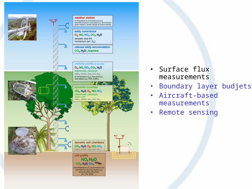
Harvard Forest
Year
1991 1992 1993 1994 1995 1996 1997 1998 1999 2000 2001
CO
2 F
lux
De
nsity
(gC
m-2
d-1
)
-12
-8
-4
0
4
8 NEERecoGEE
Data of Wofsy, Munger, Goulden et al.
Decadal Plus Time Series of NEE:Flux version of the Keeling’s Mauna Loa Graph

Heinsch et al. 2006
Global MODIS Test

FLUXNET
Cooperation with LandFlux?
•About 420 flux measurement stations•Improvement of measurements (radiation, components)•Representativity of sites, quality control, error structure, standardized procedures, validation•Model-data integration, upscaling
•Integrated use of FLUXNET and Earth observation data, carbon and water data

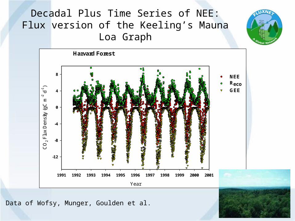
Sea
Space
Tim
e
Sec./min.
Hours/Days
Days/months
Months/years
Min./hours
cm m 10m 100m 1km 10km 100km 1000km
Canopy
ESM grid
H2O
EcosystemH2O
energy
Trace gases, O3, VOCs, NOx
Leaf/soil
Wet skinsoil Snow/ice
1e4km
Trace gases
energy
Earth System Models
Measurements
Upscaling at/from flux sites
From Artaxo, 2007
Sea
Space
Tim
e
Sec./min.
Hours/Days
Days/months
Months/years
Min./hours
cm m 10m 100m 1km 10km 100km 1000km
Canopy
ESM grid
H2O
EcosystemH2O
energy
Trace gases, O3, VOCs, NOx
Leaf/soil
Wet skinsoil Snow/ice
1e4km
Trace gases
energy
Earth System Models
Measurements
• Up-scaling• Weather forecasting• Short- and medium range • Observational data sets for
model development and model evaluation
• Point data to verify gridbox averages
• Heterogeneity
From Artaxo, 2007
Upscaling at/from flux sites

OH HO2
recyclingsource
sinkNMHC
CO, CH4, CH2OCO2, H2O
CH2Ohν
H2O2
HO2
NO2
NOhν
NO2
O3 + hvO(1D) + H2O
OH RecyclingHO2 + NO → OH +NO2 (high NOx)
HO2 + O3 → OH + 2O2 (low NOx)
Atmospheric chemistry Climate
Activation
CCN
Secondary Secondary aerosolaerosol
Primary Primary aerosolaerosol
Radiative forcing
Transport, hydrological cycle
Land cover and land Land cover and land use (use (IMAGEIMAGE scenarios) scenarios)
Anthropogenic emissionsAnthropogenic emissions Natural emissions and Natural emissions and dry depositiondry deposition
Biogeochemistry
Human dimensions= state-of-the art coupling
??
= new challenges
MeasurementsMeasurements
© Rüdiger Lang
Earth system modelling
From Artaxo, 2007

OH HO2
recyclingsource
sinkNMHC
CO, CH4, CH2OCO2, H2O
CH2Ohν
H2O2
HO2
NO2
NOhν
NO2
O3 + hvO(1D) + H2O
OH RecyclingHO2 + NO → OH +NO2 (high NOx)
HO2 + O3 → OH + 2O2 (low NOx)
Atmospheric chemistry Climate
Activation
CCN
Secondary Secondary aerosolaerosol
Primary Primary aerosolaerosol
Radiative forcing
Transport, hydrological cycle
Land cover and land Land cover and land use (use (IMAGEIMAGE scenarios) scenarios)
Anthropogenic emissionsAnthropogenic emissions Natural emissions and Natural emissions and dry depositiondry deposition
Biogeochemistry
Human dimensions= state-of-the art coupling
??
= new challenges
MeasurementsMeasurements
© Rüdiger Lang
1. Coupled Carbon Cycle capability (inc. marine and terrestrial ecosystems)2. Coupled climate-photochemistry (esp O3 and chemical lifetimes w/related emission modeling issues3. Aerosols and radiation (indirect effect w/ links to chemistry, dust, etc.)4. Dynamic vegetation (w/links to biophysical climate and trace gas emissions.
Earth system modelling

Links and collaboration

iLEAPS collaboration with GEWEX
GABLS/GMPP, GEWEX Atmospheric Boundary Layer Study
Presentation of the boundary layer in regional and global climate models
GLASS/GMPP
LUCID, Land-use and climate, Identification of robust impacts
Land-use and climate, Identification of robust impacts
Land-cover change experiments
LOCO, Local Coupled action of GEWEX Land Study
GEWEX Cloud System Study
Aerosol-cloud-precipitation-climate initiative

LUCID – Land-Use and Climate, IDentification of robust impacts
Natalie de Noblet, Andy Pitman
Scenarios of land-cover change important because humans have profoundlymodified the landscape and will continue to do so
• Different models, land parameterizations, land-cover maps, model configurations and experimental protocols
• Potential impact land-use induced land-cover change can have on the sea-surface temperatures and on ocean circulation
• Global, coupled, fixed SSTs, multiple realizations• Links to AIMES and C4MIP and C20C • At least four groups: NCAR, IPSL, CSIRO, CNRM • Use a statistical rigorous experimental design• How much of the (a) global and (b) regionally observed changes can be robustly explained by land cover ?
LUCID

Three sets of simulations have been designed to be run by different climate models.
1) The first set includes snap-shot simulations with prescribed sea-surface temperatures and sea-ice extent of the present-day climate (1992-2002) and of pre-industrial times (1870-1900). Simulations will differ by the land cover distribution that will reflect the observed changes in both crops and pasture between both time periods.
2) Transient simulations over the past 150 years (1870 to 2002), with prescribed SSTs and sea-ice will be run following the protocol designed within the C20C project ().
3) Then finally, within the European project ENSEMBLES, IPCC simulation will be re-run with coupled atmosphere-ocean general circulation models, from 1850 till 2100 following the A1b economical scenario. These simulations will be run with and without land-use induced land-cover changes.
LUCID

iLEAPS ↔ GEWEX
Global Land Atmosphere Coupling Experiment
ISLSCP – International Satellite Land Surface Climatology ProjectObservations and Models - Surface Fluxes Carbon, Water, Energy
GEWEX OBSERVATIONAL NETWORKSground-based surface radiation measurements
CEOP, Coordinated Enhanced Operation Period, Part-II (2007-2010)Implementation of the CEOP-II Integrated Observation and Data System for the Global Energy and Water Cycle as planned in Part-I •interactions between aerosols and the water cycle
WCRP-COPES Coordinated Observation & Prediction of the Earth System

Experimental & modelling
• Multispecies monitoring data
• Data with varying time resolution
• Data at various spatial scales
• Process studies
• Data assimilation
• Up-scaling, down-scaling• Local, regional, global• Inverse modelling• Weather forecasting• Climate modelling• Climate projections • Dynamic global
vegetation models• Coupled models• Earth System models

Thank you!