Embed Size (px)
Citation preview

145
LANDFORM ASSOCIATED WITH THE MAHASARAKHAM FORMATION, THE PHU THOK FORMATION AND SALT DIAPIR IN
THE KHORAT PLATEAU, NORTHEASTERN THAILAND
Denchok Monjai Department of Mineral Resources, Bangkok 10400, Thailand, E-mail : [email protected]
ABSTRACT Landsat regional scale image of Sakon Nakhon basin and Khorat basin on the northeastern Thailand can be categorized into 4 main zones. Zone A is the mountains area surrounded basins. Zone B is main flood plains and flats area on the rims of basins. Zone C is rolling landforms area on the central of basins. This zone is the largest zone. Zone D is small flood plains develops along fracture at the central area of basins. Field investigation combined with subsurface data from core explorations and seismic explorations can be established the relationship between rock Formations and the 4 main zones area. Zone A is sequences of clastic rock from the Phu Kradung Formation to the Khok Kruat Formation. Zone B is a soft rock unit of the Maha Sarakham Formation. Zone C is sequences of clastic rock of the Phu Thok Formation. Zone D is related to salt diapirs which are deformed by the lower rock salt unit of the Maha Sarakham Formation. The landform pattern of salt diapirs seems to be intruded around the Phu Tkok Formation as walls surrounded islands appearance. Key word: salt diapir, Khorat basin, Sakon Nakhon basin, Maha Sarakham Formation INTRODUCTION Khorat plateau covers an area of about 170,000 km2 in northeastern Thailand and central Laos. The Phu Phan anticlinorium trends east-west across the plateau, divided the khorat plateau into two basin namely, the Sakon Nakhon basin on the north and the Khorat basin on the south. Both basins have salt diapers, which is major rocks and/or minerals of the Maha Sarakham Formation (Fm), intruded sporadically along sequences of clastic rocks of the Phu Thok Formation. The salt diapirs are major geological harzadous to the environment e.g. saline soil, saline water and collapse sink hole. These phenomena are mainly problems of land use development for agricultural purposes. However rock salt and potash are important raw materials for various kinds of industrial uses. The Kham Ta Kla member which is the middle unit of the Phu Thok Formation is highly potential rock unit to develop for high quantity and drinkable quality of groundwater. Then, exactly information concerning distribution, location, shape, size and relation of salt diaper to the Phu Thok Formation are very important to improve the land use planning. This study is proposed relationship among topographic landform, location and distribution of salt diapir inside the basins in regional scale. The relative pattern between landform with rock units can be used as a guidance for geological detail mapping to set zone of saline soil, zone of subsurface saline water and high quality groundwater zone.
STUDY AREA The study areas are situated at the Sakon Nakhon basin and the Khorat basin (Fig. 1). They are bounded by latitude 14030′ to 18030′ north and longitude 101045′ to 15030′ east with area of approximately 53,000 km2
(17,000 km2 of the Sakon Nakhon basin and 36,000 km2 of the Khorat basin). Some part of the Sakon Nakhon basin is extended from northeastern Thailand into Vientiane and Savannakhet of Lao People’s Democratic Republic. The elevation of both basins is average between 150-190 m. Nam Song Kram and Nam Khong are major rivers on the Sakon Nakhon basin while Nam Mun and Nam Chi are major rivers on the Khorat basin. STRATIGRAPHY OF THE STUDY AREA The Khorat plateau consists of continental sequences of red beds of Mesozoic age. This sequence named the Khorat Group, consists of 9 formations (Meesook, 2004) from bottom to top as follow: the Huai Hin lat Fm., the Nam Pong Fm., the Phu Kradung Fm., the Phra Wihan Fm., the Phu Phan Fm. the Khok Kruat Fm., the Maha Sarakham Fm. and the Phu Thok Fm. Rock units at mountain ranges area around the Sakon Nakhon basin and the Khorat basin are sequence of mudstone, siltstone, sandstone and conglomerate from the Phu Kradung Fm. to Khok Kruat Fm. The Maha Sarakham Fm and the Phu Thok Fm. exposes at central part or low elevation area in both basins. The Maha Sarakham Fm. consists of thick bedded of salt layer interbedded with soft claystone. It can be divided into five units from bottom to top: the lower salt unit, the lower clastic unit, the middle salt unit,
GEOTHAI’07 International Conference on Geology of Thailand: Towards Sustainable Development and Sufficiency Economy

146
the middle clastic unit and the upper salt unit. The Phu Thok Fm. consists of sequences of sandstone, siltstone and mudstone. It can be divided into three members from bottom to top as follows the Na Wa member, the Kham Ta Kla member and the Phu Thok Noi member (Monjai,
2006). Overlying the Maha Sarakham Fm. and Phu Thok Fm. are unconsolidated clay, sand and gravel of Quaternary age which are deposited by fluvial, flood plain and terrace.
Figure 1 Landsat image shows study area and 4 zones of landform associated with the rock units.
Legends Symbols Mountain and High land landform (Phu Kradung Fm.-Khoh Kruat Fm.) Contact Zone A-B Main flood plain on the rim of basin (Maha Sarakham Fm., Na Wa and Kham Ta Kla member) Contact Zone B- C and D Rolling landform on the central of basin (Phu Thok Fm.) Contact Zone C-d Small flood plane superimpose on zone C (Locally of Salt diaper)
ZONE A
ZONE B
ZONE C
ZONE D
C
C C C
C C
C
C
D
C C
C
D D
D
C
C
ZONE A
ZONE A (Phu Phan Range)
ZONE A
ZONE B
ZONE B
ZONE B
ZONE B
ZONE B
ZONE C, D
C C
ZONE C, D
C
C
C
C
C C
C
C
C
D
D
C
C C
C C
C
C
C
B
D
C
C D
D
D
D
B
D D C
C
C
C
C
C
C
C C
C
C
C
D
Vientiane
Udon Thani Sakon Nakhon
Khon Kaen
Nakon Ratchasima
Ubon Ratchathani
Sakon Nakhon Basin
Khorat Basin
Laos1020180
1020
1040
Bangkok
Study Area
0 50
100 k
N
Fig 2
Fig 3
147
METHODOLOGY
This study is systematically conducted in following order: First, I perform an interpretation of regional scale landsat image to produce the geologic map of the basins. Second, four locally areas represented geologic rock unit at the edge and central of both basins are selected for field investigation. The Sa Wang Dan Din village on the southern rim area and None Sabaeng village on the central area are selected area for field investigation on Sakon Nakhon basin. The other two areas are north of Khon Kaen province on the northern rim area and Borabue district on the central area, are selected for field investigation on the Khorat basin. Third, I collect and study subsurface data from core drilling and seismic exploration on purpose to correlate each rock formations in the basin. Forth, data analysis of all data that leading to summarize relationship between landform and rock unit distribution.
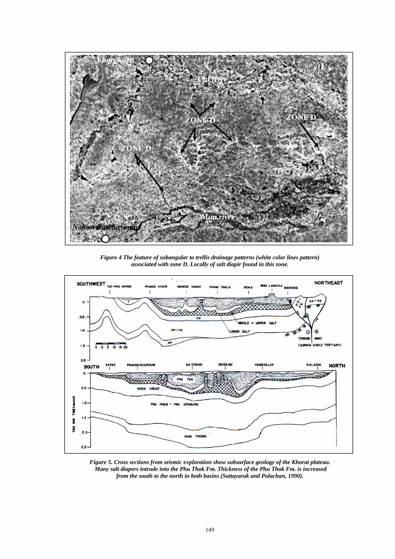
RESULTS Landsat image analysis can be divided the study area into 4 main zones (Fig. 1). Zone A is the area to besiege the basin area. Characteristic feature of zone A is light gray tone, coarse texture, mountain and hilly landform, dendritic drainage pattern, moderate density, medium-high resistance, sharp boundary, well bedding, gentle attitude, high relief. Zone B is on the rim of the basin and dominated many swamps and small lakes. Characteristics feature of zone B is medium to gray tone, fine texture, flat landform, angular pattern, low to moderate density, low resistance, sharp boundary, none bedding, low relief. Zone C is on the central of the basin. Characteristic feature of zone C is gray tone, coarse texture, rolling landform, dendritic pattern, moderate to high density, medium-high resistance, sharp boundary, massive bedding, gentle attitude, high relief. Zone D is superimpose on zone C. Characteristic feature of zone D is light gray tone, fine texture, flat and alluvium deposit landform, parallel pattern, low density, low resistance, inferred boundary, none bedding, low relief. Field investigation founded that zone A is mountainous area, consists of sequences of clastic rock of the Phu Kradung Fm. to the Khok Kurat Fm. Zone B is zone of normally distribution of the Maha Sarakham Fm. The landform of zone B at Sa Wang Dan Din is flat area along the Phu Phan range (Fig. 2). This flat area is deposited by weather sand from the rock of the Phu Phan range. The landform of zone B at north of Khon Kaen area is flood plain of Chi river which founded terrace of gravel bed cover on the lower clastic unit and the middle clastic unit of the Maha Sarakham Fm. (Fig. 3). Zone C is the rolling landform, interpreted as distribution of the Phu Thok Fm. There are many ground water wells developed in this zone i.e. the Tha Phra area (8 km to the south of Khon Kaen city). The Kham Ta Kla member of the Phu Thok Fm. is very high potential aquifer. Zone D is small flood plain along small streams. These streams develop along fractures and drainage patterns are sub-angular to trellis
drainage pattern (Fig. 4). The small flood plain of zone D at Ban None Sabaeng and Borabue area is deposited by present sediments in fluvial system. Most of saline soil and saline water are found in this zone. The elevation difference of zone C and zone D is average 15-25 meter. Subsurface interpretation showed the feature of salt layer, location of salt diaper and thickness of the Phu Thok Fm. which is overlain the Maha Sarakham Fm. Stratigraphic correlation of core exploration at Khon Kane city showed normally bedded of salt layer in zone B. The distribution map of salt dome (Sattayarak and Polachan, 1990) showed the salt diapir especially found in zone D. Thickness of sediment deposit over salt diapir at Ban None Sabaeng is average 60 meter (Jenkunawat et al, 2004).Thickness of the Phu Thok Fm. from core drilled hole number K-66 at Borabue is 793 meter (Suwanich, 1986).Thickness of the Phu Thok Fm. on the Sakon Nakhon basin from core drilled hole number K-7 at Ban Dung is 580 meter (Suwanich, 1986), however the total thickness is 797 meter (Monjai, 2006). Cross section from seismic explorations indicate many salt diapirs intruded in the Phu Thok Fm. and thickness of the Phu Thok is increased from the south to the north in both basins (Fig. 5, Sattayarak and Polachan, 1990). Subsurface boundary between the Maha Sarakham Fm. and the Khok Kruat Fm. in the Khorat basin is deeper than the Sakon Nakhon basin (Satarugsa et al, 2005). DISCUSSIONS AND RECOMMENDATIONS The salt diapir can be especially found into zone D associated with fractures on the clastic rocks of the Phu Thok Fm. It is possibly be the lower salt unit of Maha Sarakham Fm. deformed to salt diapir by loading from clastic rocks of the Phu Thok Fm. (Monjai, 2004). They have a few sequences of the Phu Thok Fm. overlain the salt layers in zone B however salt layer have not develop to salt diapir because of loading is not enough to move salt to platicsity. The pattern of zone B and D, surrounded zone C, control by fracture sets patterns and interpreted to be boundary between the Maha Sarakham Fm. Dissolution process of salt layer is possible factor controlling differentiate elevation landform of zone B, zone C and zone D. The salt layer in zone B and zone D is easy to dissolve so that erosion of the Maha Sarakham Fm. on these zones is faster than the Phu Thok Fm. of zone C. Some areas such as Nong Hang at Sakon Nakhon province caused salt subsidence from dissolution process built up to be large natural lake. This study presents relationship between regional topography and salt diapers then further study should be on detail about thickness and boundary of the clastic rocks of the Phu Thok Fm., the shape of salt diapir and various thicknesses of sediment deposit overlain salt diapir. Geophysic explorations can be used to study the location and feature of salt diapir. These data are very important and very useful to improve saline soil problem, to control saline water and to develop groundwater in the basins.

148
Figure 2. Landsat image at the south of Sa Wang Dan Din area shows sharp contact between zone A and B and between zone B and zone C.
Figure 3. Landsat image at the north of Khon Kaen area shows sharp contact between zone A and B and between zone B and zone C. Zone B is flood plain of Chi river with dominated many swamps and small lakes.
Zone A
Zone B
Zone B Zone C
Zone C Zone C
Na Wa Member
Na Wa Member
Na Wa
Zone D
Zone D
Zone C
Zone A
Zone B
Kham Ta Kla Member
Kham Ta Kla Member
Chi river Swamp
Khon Kaen
Zone B
149
Figure 4 The feature of subangular to trellis drainage patterns (white color lines pattern) associated with zone D. Locally of salt diapir found in this zone.
Figure 5. Cross sections from seismic exploration show subsurface geology of the Khorat plateau. Many salt diapers intrude into the Phu Thok Fm. Thickness of the Phu Thok Fm. is increased
from the south to the north in both basins (Sattayarak and Polachan, 1990).
Khon Kaen
ZONE D
ZONE D
Chi river
Mun river
ZONE D
Nakon Ratchasiman

150
CONCLUSIONS
The regional landform on the Sakon Nakhon basin and the Khorat basin form landsat image interpretation can be divided into 4 main zones. Zone A is the mountainous areas around the basin. Zone B is main flood plain and terrace situated on the rim of the basins. Zone C is rolling landform cover most of area in the central of the basins. This zone is associated with the Phu Thok Fm. Zone D is small flood plains which is superimpose on zone C. The fracture sets in the Phu Thok Fm. control the stream system to develop small flood plains of zone D. The drainage patterns of zone D are sub-angular to trellis patterns. Salt layer of the Maha Sarakham Fm found in zone B and D but most of salt diapir distributed on zone D. It is supposed that salt layer is deformed to salt diapir by loading of the Phu Thok Fm. over on the salt layer.
REFFERNCES Jenkunawat, P., Supphassumthornkul, T., and Gunnaleka, S.,
2003, Results of drilling to study occurrence of salt cavities and salt subsidence at Ban Nonsabaeng and Ban Nong Kwang, Bureau of Mine and Concession, Department of Primary Industries and Mines, Bangkok, Thailand: 10.
Monjai, D., 2004, Subsurface geology in Sakon Nakhon Basin, Proceeding of Annual Meeting, Department of Mineral Resources, Bangkok, Thailand, 51-63, (in Thai).
Monjai, D., 2006, Facies Genesis Analysis of the Phu Thok Formation and the Upper Clastic Cap Rock of the Maha Sarakham Formation, [M.Sc thesis in Geotechnology], Khon Kaen University, Khon Kaen, Thailand, 142 pp. (in Thai).
Satarugsa, p., Youngmee, W., and Meesawat, S., 2005, New Regional Boundary of Maha Sarakham Formation in the Northeastern Thailand: Results from 2D Seismic Mapping, Proceeding of the International Conference on Geology, Geotechnology and Mineral Resources of INDOCHINA, Khon Kaen, Thailand, p.212-220.
Sattayarak, N., and Polachan, S., 1990, Rocksalt underneath the Khorat Plateau, Proceeding of Annual Meeting, Department of Mineral Resources, Bangkok, Thailand, p. 1-14, (in Thai).
Suwanich, P., 1986, Potash and rock salt in Thailand, Appendix A, Department of Mineral Resources, Bangkok, Thailand: 252 pp.