Embed Size (px)
Citation preview
Landforms of coastal deposition, to include
beaches, spits, on-shore and offshore bars, tombolos and
cuspate forelands.You should be able to describe and explain the formation of each landform listed. You must be able to use annotated diagrams and sketches in your descriptions and explanations. You need to know located examples, primarily, but not exclusively, from two contrasting stretches of coastline (North Devon and Dorset Coast)

Different beaches as sediment stores
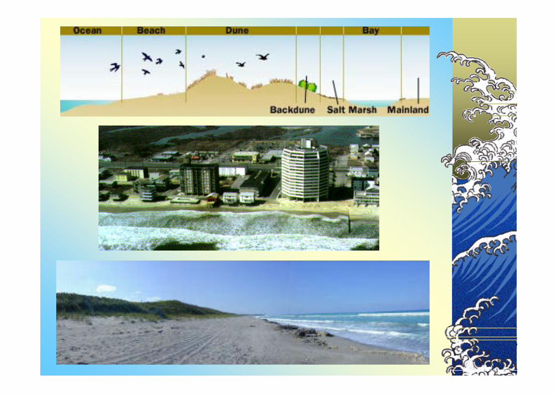
A beach may be a store of sediment trapped in a bay or it may be a mobile stream of sediment moving with longshore drift along a coast. The next diagram shows the main components of a beach profile.

The material may be derived from the following sources:
• Cliff erosion, particularly from headlands.
• Sediments that have been moved by waves, tides and currents fromthe offshore zone. Chesil Beach is a good example of this and it is probably derived from relict material that was gradually swept up the beach as se levels rose between 18,000 and 6000 years ago.
• River sediments that have been brought to the coast.
• Beach material that has been moved along the coast from neighbouring sources, by longshore drift.
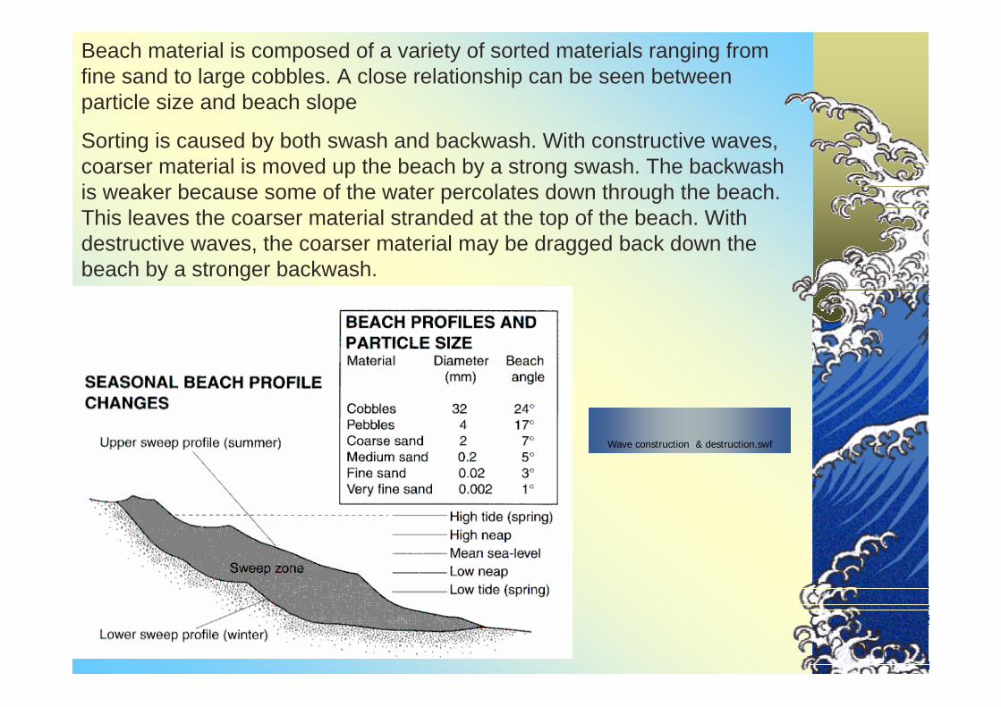
Beach material is composed of a variety of sorted materials ranging from fine sand to large cobbles. A close relationship can be seen between particle size and beach slope
Sorting is caused by both swash and backwash. With constructive waves, coarser material is moved up the beach by a strong swash. The backwash is weaker because some of the water percolates down through the beach. This leaves the coarser material stranded at the top of the beach. With destructive waves, the coarser material may be dragged back down the beach by a stronger backwash.
Wave construction & destruction.swf

Beach profile on the Pebble Ridge at Westward Ho!

Changes in the beach profile. Beaches are dynamic sediment stores, which change in response to changes in wave energy, wave direction and tides. In general, winter waves tend to be more destructive than summer waves, so on many beaches, the profile changes with the seasons and with changing weather conditions.Beach profiles will also vary according to the type of beach material, with pebble and cobble beaches displaying the steepest profiles. Shingle beaches often have steep slopes on their landward side (such as Chesil Beach). Such beaches have been built by storm waves and display distinct ridges or berms, each one representing a different storm event. The top of the beach is marked by the highest storm beach, composed of the biggest boulders thrown by the most energetic waves.
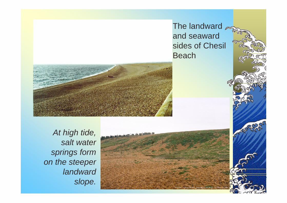
The landward and seaward sides of Chesil Beach
At high tide, salt water
springs form on the steeper
landward slope.

Well sorted and rounded pebbles on Chesil BeachWell sorted and rounded pebbles on Chesil Beach

Swash Aligned Beaches. Most beaches are concave towards the sea. This is largely due to wave refraction. The beach faces tend to orientate themselves parallel to the wave fronts. Both the eastern end of Chesil Beach and the beach at Saunton Sands in North Devon are good examples of swash-aligned beaches.
Drift aligned beaches. Many beaches show alignment at an angle to the wave direction and experience longshore drift. This occurs on the beach at Westward Ho! and the western end of Chesil Beach
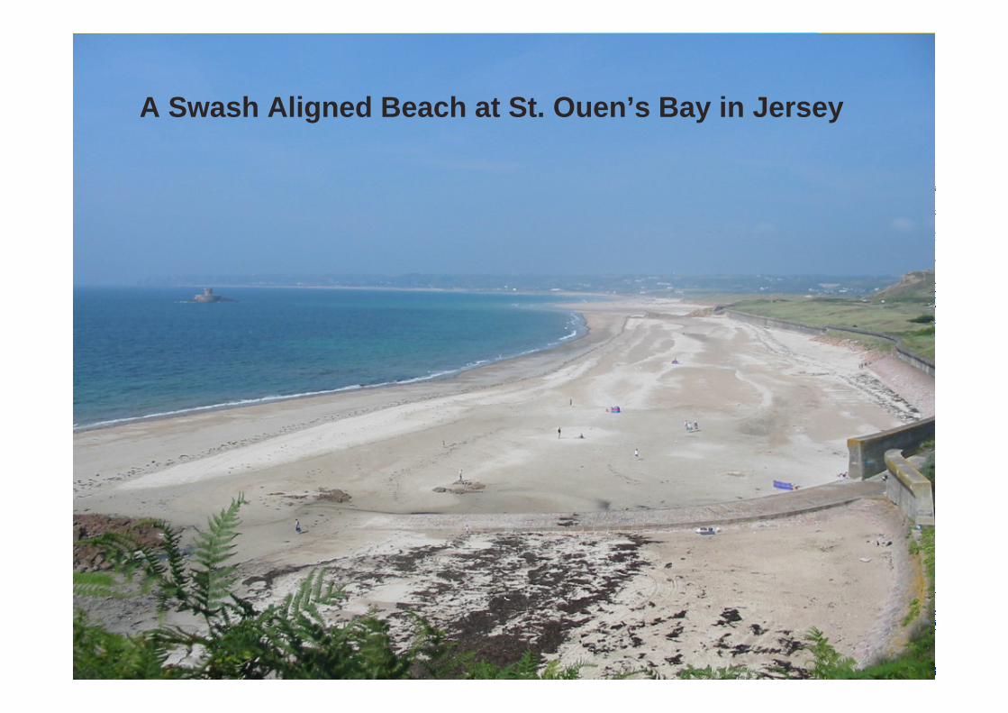
A Swash Aligned Beach at St. Ouen’s Bay in Jersey
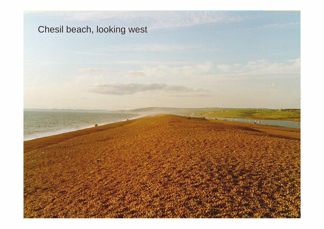
Chesil beach, looking west

Chesil beach and the Fleet (lagoon).The beach is swash aligned

Spits, such as the pebble ridge at Westward Ho! form when there is a landward change on beach alignment. The Pebble Ridge probably started life further west extending from Rock Nose (see OS map) northwards where the line of the coast turns eastwards.
The spit has since migrated eastwards and is still doing so. The origin of the pebbles is uncertain. They may be relict sediments, which have been dragged up with rising sea levels, or they may be the remains of a lag deposit, which was created when a massive rotational landslide occurred at Keivills Wood, further west along the coast near Bucks Mills in the 11th century or earlier. Longshore drift will have moved the material 15km eastward.
Spits.

The Pebble Ridge Spit at Westward Ho!

Evidence of the migration of the Pebble Ridge Spit from west (left) to east (right).
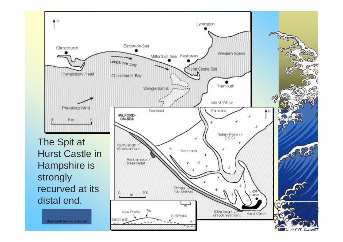
The Spit at Hurst Castle in Hampshire is strongly recurved at its distal end.
Baymouth bars & spits.swf

Spit at the entrance to Chichester harbour providing protection for a salt marsh
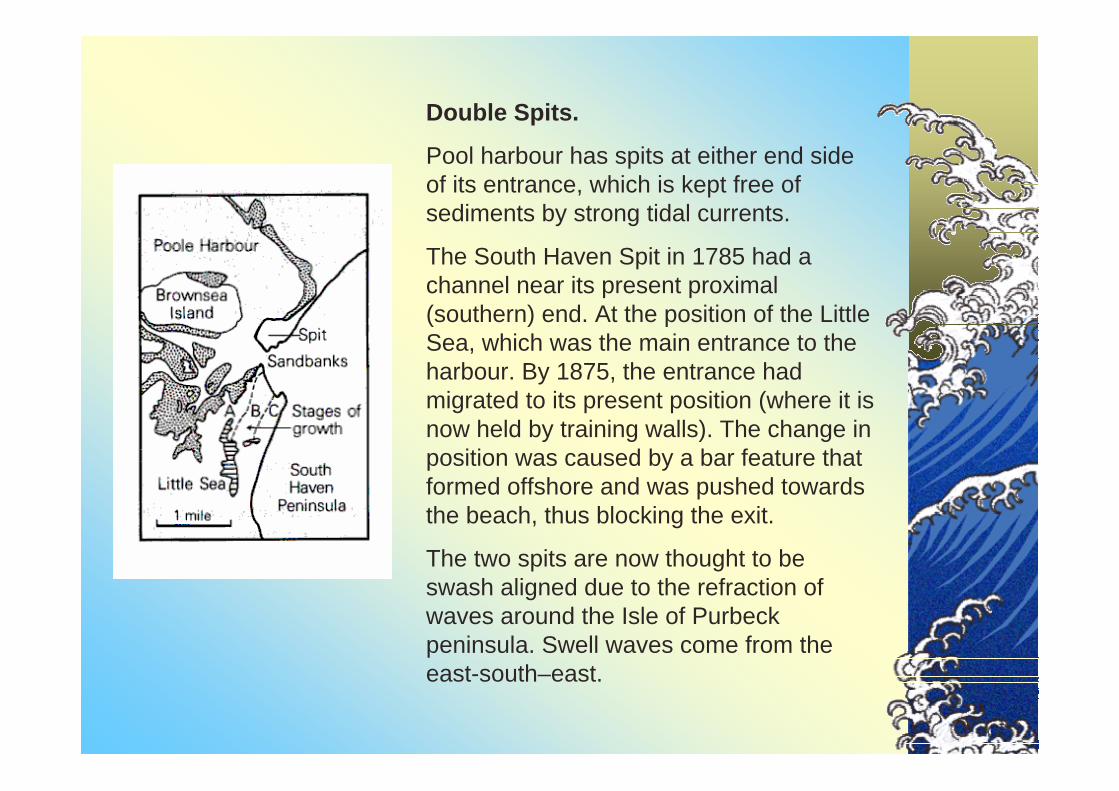
Double Spits.
Pool harbour has spits at either end side of its entrance, which is kept free of sediments by strong tidal currents.
The South Haven Spit in 1785 had a channel near its present proximal (southern) end. At the position of the Little Sea, which was the main entrance to the harbour. By 1875, the entrance had migrated to its present position (where it is now held by training walls). The change in position was caused by a bar feature that formed offshore and was pushed towards the beach, thus blocking the exit.
The two spits are now thought to be swash aligned due to the refraction of waves around the Isle of Purbeck peninsula. Swell waves come from the east-south–east.

The southerly tip of the Sandbanks spit (and Brownsea Island).

Onshore and offshore bars. Bars are deposits of sand, mud or shingle occurring in the sea more of less parallel to the shore, and sometimes linked to it. A bar lies across the mouth of the Taw/Torridge Estuary, which may relate to fluvial deposition as river energy declines. Bars are sometimes intermittently coveredby the tide or permanently submerged. If the bar is permanently exposed, above the water level it will form a bay bar, barrier beach or tombolo.
Chesil Beach is a Tombolo, joining the Isle of Portland to the mainland at Chiswell.
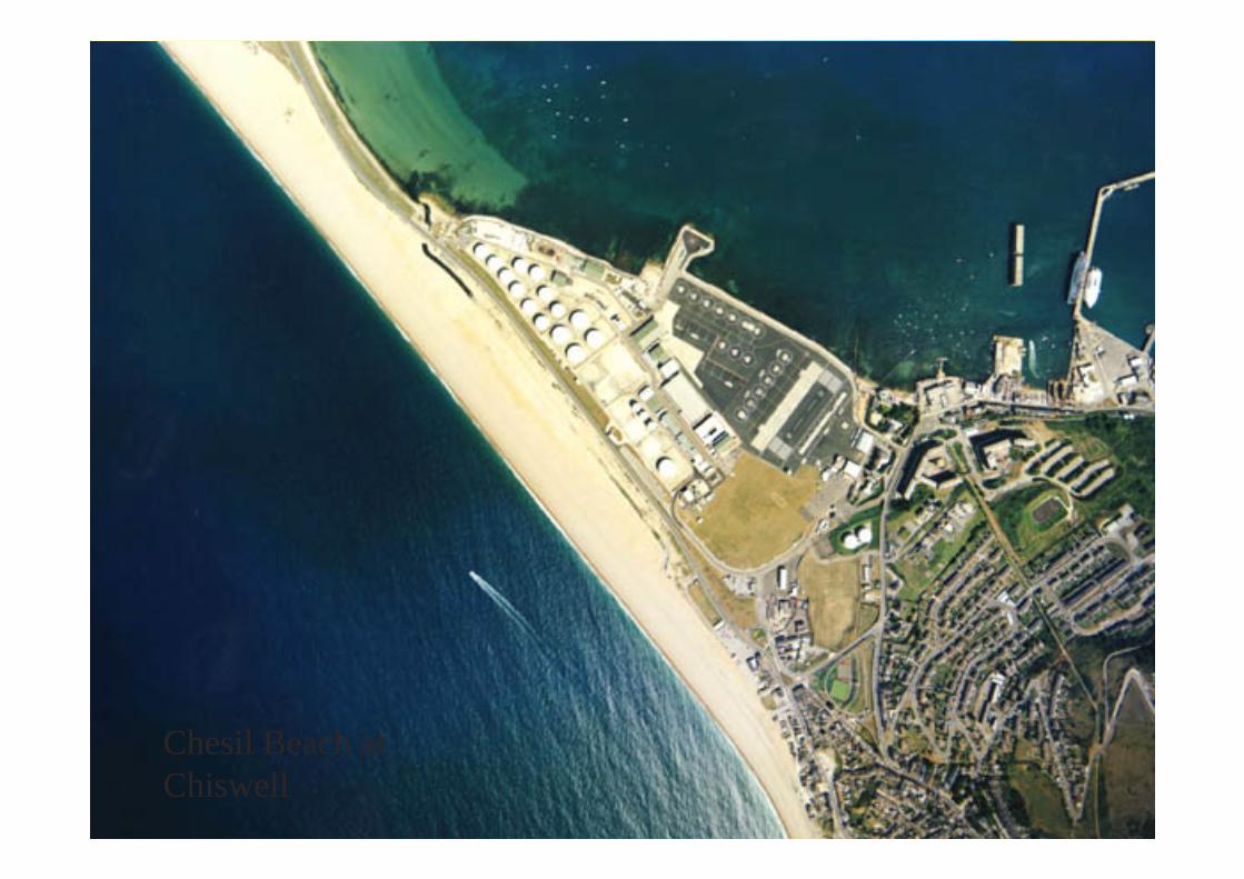
Chesil Beach at Chiswell

Tombolos are beaches that join an island to the mainland. They are caused when a spit of bar grow to link the island to the mainland. The tombolo at Chesil Beach is swash aligned. It is some 30km long and up to 15m high. The lagoon (called “The Fleet”) created by the bar is also filled with brackish water. At high tide, saltwater springs flow from the landward side of the beach.

Barrier Islands
This diagram shows an offshore barrier island off the east coast of the USA, for example along the Texas coast between Galveston and Brownsville. The bars may have formed with rising sea levels at the end of the Pleistocene. The beaches may display longshore drift and can be breached by storms scubas tropical cycles.
Scolt Head Island in North Norfolk is a barrier beach island.


Cape Hatteras
A true colour satellite image showing barrier islands on the east coast of the USA.
The cloudy water in the lagoons west of the barrier island were caused by a period of heavy rainfall and high river discharge.

Cape Canaveral in Cape Canaveral in FloridaFloridaA “false colour” infrared image. Water appears black and vegetation appears red

Loe Bar near Porthleven in Cornwall is a shingle barrier or barrier beach. The shingle is swash-aligned and has probably been driven landward from the offshore zone.
Although rivers drain into the Loe, the water seeps through the shingle barrier. At High tide, seawater seeps in the opposite direction so the water in the Loe is Brackish.
Shingle BarsShingle Bars


A. The first stage was the formation of a spit from Fairlight Head, which was seaward of its current position. The spit may have grown right across to Hythe by the 13th Century. For some reason, the supply of shingle from the west was diminished and it began to erode from the proximal end, with the shingle re-deposited at its distal end.
B. The shingle spit then rotated to face the dominant waves.
C. By 1794, further modification took place until the spit was swash aligned. Sedimentation in the water in lee of the spit, which had become separated from the sea, began to form Romney Marsh, As shingle drifted from the south west shore, around the end of the spit, it continued to build the parallel ridges on the east side. This process continues today
Cuspate Cuspate Forelands: Forelands: Dungeness in Dungeness in KentKent


![Landforms Mady By Wind [Desert Landforms]](https://img.pdfslide.net/doc/110x75/56813971550346895da1066c/landforms-mady-by-wind-desert-landforms.jpg)