Embed Size (px)
Citation preview

Landmark Hierarchies in Context
Stephan WinterDepartment of Geomatics
The University of Melbourne, [email protected]
Martin Tomko1
CRCSI, Department of GeomaticsThe University of Melbourne, [email protected]
Birgit Elias2
Institute of Cartography and GeoinformaticsUniversity of Hannover, Germany
Monika SesterInstitute of Cartography and Geoinformatics
University of Hannover, [email protected]
1Supported by the Cooperative Research Centre for Spatial Information, whose activities are funded by the Aus-tralian Commonwealth’s Cooperative Research Centres Programme.
2Supported by the German Research Foundation (DFG).

Abstract
We are interested in the generation of distinguishing place or route descriptions for urban environments.Such descriptions require a hierarchical model of the discourse, the elements of the city. We postulate thatcognitive hierarchies, as used in human communication, can be sufficiently reflected in machine-generatedhierarchies. In this paper we (a) propose a computational model for the generation of a hierarchy of one ofthese elements of the city, landmarks, and (b) demonstrate that a set of filter rules applied on this hierarchyderives distinguishing route descriptions from spatial context.

Keywords: navigation, landmarks, hierarchies, route directions, place descriptions.
1 Introduction
When communicating routes or place descriptions people refer typically to landmarks. These landmarksare cognitive anchors of the learned environment that are assumed to be shared with other people, or at leastwith participants of a particular conversation. Furthermore, there is evidence for a hierarchical structureof cognitive spatial representations [36, 13], from which one can infer a hierarchical system of landmarks,distinguishing, let us say, landmarks representing the city from landmarks representing a street intersection.This hierarchy is also reflected in route or place descriptions, if the speaker assumes that the listener sharessome knowledge of the environment [33, 27, 2].
If we want to design geographic information services, such as navigation services or location-based ser-vices, that are able to communicate about space hierarchically, we need to answer the following questions:
1. What are the driving forces for a hierarchical organization of landmarks, and how can we automati-cally organize a set of landmarks in a hierarchical system?
2. What are the specific properties of a ranked order? Is it a levelled hierarchy? Can we, for example,find ontological or at least operational specifications of levels, and is the mapping of a landmark intothis system unique?
3. What about the duality of landmarks and their reference regions [3, 23] – is there a dual hierarchyof regions? What are the properties of this dual hierarchy, and if the mapping of landmarks is notunique, i.e., if individual landmarks can occur at different levels in the hierarchy, do their referenceregions vary with the level? In other words, what is the spatial context of a landmark?
4. Finally, given a hierarchy of landmarks, how does a geographic information service make use ofit? What are the rules for transiting between the levels in a communication process? How are theyreflected in the dual hierarchy?
In this paper, we try to answer these questions. The underlying hypothesis is that we can find a formal modelfor a machine-generated hierarchy of landmarks from geographic datasets. Ideally the ranking criteria inthe model are motivated by cognitive relevance.
We start with collecting previous work on landmark identification and the use of landmarks in route de-scriptions (Section 2). The known methods of identifying landmarks automatically from datasets all applyregionalized approaches, which makes sense on the basis that an object can only become a landmark relativeto other objects in that region. We take advantage of the regionalization, and exploit it to derive hierarchiesof landmarks from examples. The observations help us to derive some general properties of a model forsuch hierarchies (Section 3). In Section 4 we present a formal model and algorithm to determine landmarkhierarchies. Then we propose a procedure to identify and order landmarks for a limited domain, buildings.The procedure will be applied to a test area to demonstrate its behavior (Section 5). Finally we adapt anexisting formal model for generating route or place descriptions from region hierarchies to landmark hi-erarchies, with respect to spatial context (Section 6). We expect to find a complementary hierarchy to thehierarchies of other elements of the city [21] that can be used, either on its own or in combination, forhierarchic route or place descriptions. The paper concludes with a discussion and an outlook in Section 7.
2 Previous work
In this section we review the relevant literature on landmarks, hierarchic organization of cognitive space,and spatial hierarchies.
1

2.1 Landmarks
Landmarks are features in the physical environment that are relatively better known and define the locationof other points [28]. Since landmarks can be experienced, they are represented in cognitive representationsof space as anchor points [3]. Because of their special role in cognitive representations—they may evenbe the first class citizens of cognitive representations—they are particularly suited for human-to-humancommunication [6, 14].
Landmarks are one of the five elements Lynch [21] has identified in the image of a city. These are place,path, barrier, district, and landmark. Today it is a common view that any element of a city can havelandmark quality according to the above definition [e.g., 31]. However, in this paper we limit ourselves toLynch’s more narrow view, and consider landmarks as point-like elements in the city.
Literature provides ample evidence that cognitive representations of space are hierarchical [36, 13]. Hierar-chic representations turn out to be efficient in cognitive spatial reasoning and communication. For example,place descriptions based on hierarchies are shorter, and hence, more relevant compared to descriptions onone level of granularity [33, 27, 26]. Hence, computational linguistics proposed hierarchical referring ex-pressions [2, 5]. Route descriptions can be generated using the same principles [45], and we will come backto this point in Section 6. Another example for the efficiency of hierarchic spatial reasoning is the routegeneration itself [46, 42], which motivated the development of hierarchical spatial data models for use inartificial intelligence [40, 17]. In the cartographic context, the metaphor of a cognitive zoom was developedon these data models [10, 37].
2.2 Categorization of landmarks
Landmarks are frequently categorized into global and local landmarks. Since landmarks are used in twodistinct contexts—wayfinding and representation of spatial knowledge [28]—the meaning of this catego-rization varies.
In a wayfinding context, global landmarks are typically used for conveying directional information; they areat a distance, or off the route. Local landmarks are typically used for conveying positional information; theyare close to the route, and are sometimes further categorized into landmarks at decision points, landmarksat potential decision points, and on-route landmarks along segments [20, 15].
In the context of spatial knowledge, landmarks are considered as anchors of cognitive representations ofspace. In this context, a local landmark is a landmark that refers to a region defined by vista space, and aglobal landmark is a landmark that refers to a larger region [22]. With this weak definition at hand, we canalready assume that there will be several levels of global landmarks in a city, distinguishable only by thesize of their reference region. A sharper definition will be possible after formalizing the reference regions.
The notions of landmark hierarchies and global landmarks in spatial knowledge are related to an observationin game theory [32]: if two persons have to meet in a reference region (i.e., in a given spatial context) butcannot communicate with each other to arrange a meeting, these persons will likely decide to go to itslandmark. Additionally they choose a landmark in the temporal domain for the expected meeting time.This most salient point in space-time is nowadays called Schelling point.
3 Landmark hierarchies
In this section we show with examples that (point-like) landmarks in a city have a cognitive hierarchy, form-ing a partial order. We also show that the landmarks have a dual in their reference regions. Consequentlythe reference regions form the same hierarchy.
2

3.1 Motivational example
People naturally rank landmarks. For example, when entering a taxi at Melbourne’s airport Tullamarine,it makes perfect sense to tell the taxi driver “To the Royal Hospital, then turn right, and you will see a 7-Eleven” (Figure 1). The Royal Hospital, located on the edge of Royal Park, is in a suburb next to the centralbusiness district, and about 20km from Tullamarine. Being the premier health care provider in Victoria,the hospital is well-known, and one can assume that the taxi driver will know it – and find the way. Notethat other cities in Australia have a Royal Hospital as well, but this seems not to concern the taxi driver inthis situation. However, Melbourne has several hospitals, and hence the passenger felt impelled to namethe specific one [45]. In contrast, the 7-Eleven would not have worked as the first reference. The companylogo and facade makes it distinct in its neighborhood, but business directories list 259 7-Eleven shops inMelbourne. Hence, a 7-Eleven is a local landmark, distinguished only in vista environments, and in thegiven expression it is dependent on the hospital.
Figure 1: Melbourne’s Royal Hospital, on the edge of Royal Park, is close to the Central Business District,and about 20km from Melbourne’s international airport, Tullamarine.
Now consider a phone conversation I have with my friend. She is currently in the Royal Park and I want tomeet her in a cafe close to the Royal Hospital. I might say: “Go to the hospital, and then turn right”. Thelandmark referred to is the same as before, although in this case the expression omits the specifier. However,in this case the hospital is needed for an orientation task in a much smaller spatial environment. Hence,the elements activated in the cognitive representation of the listener by this expression are more detailedand closer to the hospital itself than in the first instance. For example, my friend will have no difficulties inorienting herself in the direction of the hospital at her current location, something that is not as easy for thetaxi driver at Tullamarine, and also not necessary in his context.
Note that I could also have said to my friend: “At the corner is a hospital; turn right there”, referringto an unspecific instance. In this case the hospital would serve only as a local landmark, since it can bedistinguished only in vista space. When coming even closer to the hospital, one might refer no longer tothe hospital as such, but to parts of it, such as the hospital’s main entrance, or its Block B.
Symbolic and metaphoric use of landmarks in human communication is beyond the context of route orplace descriptions, and hence, not considered here.
3.2 A rank order of landmarks
A cognitive rank order of landmarks appears natural, but for different reasons. We identify here orders inprominence, uniqueness, or salience.
3.2.1 Prominence
People’s knowledge of landmarks is different, that means some are more prominent than others. For ex-ample, the Royal Hospital is known by more people than the (specific) 7-Eleven on the same corner as thehospital. Prominence imposes a partial order.
3

3.2.2 Uniqueness
Some landmarks are unique in larger spatial contexts than others. For example, the Royal Hospital is uniquein Melbourne, but the 7-Eleven at the corner is unique only in the vista space of the intersection (as far asone being at that intersection can be sure). That means the size of the region which is associated with the useof a landmark in communication is a distinctive characteristics imposing another partial order. We call thisregion a reference region. These regions have no sharply defined boundaries. Note that even the visibilityarea of landmarks can vary largely, which will become relevant later (Section 5).
The order defined by uniqueness is independent from the order by prominence. In our example the hospitalrefers to different spatial contexts. Although the reference regions are different, the hospital’s prominenceis the same. In another example, Melbourne has a building of a unique blue color. Although the color isunique, the building is by far not as prominent as the Royal Hospital, in the context of route directions fromthe airport.
3.2.3 Salience
When searching for ways to automatically identify and select landmarks for route directions, some authorstried to identify observable and measurable properties of features that determine their salience [31, 7].These attempts go back to a classification of Sorrows and Hirtle [34], who considered visible, structuraland semantic properties of features as relevant in this context. A feature is salient, i.e., stands out out inits visible, structural or semantic properties, relative to other features nearby. A salient feature is calleda landmark. Salience by these properties imposes another partial order, saying, for example, that the 7-Eleven at the corner is visually, semantically or structurally more salient than the parking garage next to it.However, this measure is dependent on prominence and uniqueness. A correlation with prominence can beconcluded from the visible, structural or semantic properties of a landmark: at least one of them has made itprominent. A correlation with uniqueness can be concluded from the way of computation, which measuresthe distinction.
3.3 Properties of the rank order
Prominence, uniqueness, and salience lead in principle to different partial orders. Since salience measuresare dependent on prominence as well as on uniqueness, we argue that salience measures reflect to some ex-tent all three reasons for ranked landmarks in cognitive representations. Furthermore, the three approachesare all quantitative, although we have not discussed ways of quantification. This means, although the ap-proaches allow a ranking of landmarks, the order is not yet a hierarchy of discrete levels.
It becomes now self-evident that features salient in a local neighborhood are local landmarks, and featuressalient in a global neighborhood are global landmarks. For example, the Royal Hospital in Melbourne isunique in Melbourne in its reputation, and in some of its highly specialized functions. It belongs to thesalient features in Melbourne. In contrast, the 7-Eleven nearby is only salient when compared with otherbuildings nearby. Other than this correlation with their reference region, we have seen that the more salientlandmarks are used over a range of contexts, and hence, have varying, context-dependent reference regions.
4 Formal models for landmark hierarchies
In this section we generate a levelled hierarchy of landmarks. For this purpose we adapt a method ofidentifying landmarks. Since being a landmark is a property relative to other features in the neighborhood,identification methods are regionalized. We exploit just this property for a levelled hierarchical ordering.We describe an operational procedure to come up with such an order.
4

4.1 Identification of landmarks
Some methods of identifying landmarks come with a continuous measure of salience [31, 11]. Continuousmeasures of salience can be used for classification, e.g., for selection processes [31]. Other methods imme-diately classify a feature, e.g., by the length of the description of the feature’s distinctiveness [7], and thus,make a Boolean decision on salience. Boolean classification methods do not lend themselves automaticallyto create an order; one needs to consider additional properties for a quantification. We will adapt one ofthese regionalized classification methods further.
Other classification methods exist, which are not regionalized or have no spatial grounding at all. Winter andTomko [47] explore a search engine’s page counts of street addresses to generate a hierarchy of prominence.Geographic co-referencing is used to reconstruct spatial relations of nearness [29, 1], and within nearnessrelations one can again rank according to the direction of the references [38]. For example, an expression“the 7-Eleven near the Royal Hospital”, and many similar expressions on the Web referring to the RoyalHospital, make this a prominent node. Since we want to exploit the duality of landmark and its referenceregion, these non-regionalized approaches to identify landmarks are not considered further in this paper.
4.2 Partitions by landmarks
We start from the assumption that any location in space can be described by references to landmarks.This means that any point in the Euclidean map plane is in at least one landmark’s reference region, or,reference regions are jointly exhaustive. We also postulate that the reference regions are pairwise disjointat each level of a hierarchy. This postulation is supported by two arguments: a practical and a theoreticalone. From a practical perspective, if they were not pairwise disjoint the choice of landmarks to describea location would be ambiguous. Since landmarks are used so successfully, this is implausible. From atheoretic perspective, one can assume a landmark forming a field of dominance decreasing with increasingdistance from the landmark below any threshold. A landmark’s reference region is then defined as the areawhere the dominance of the landmark is stronger than the dominance of any other competing landmark.This idea is formalized for cellular networks [18]. A similar concept of influence regions, represented byqualitative degrees of proximity, has been used for the definition of neighborhood [24].
These two properties mean that the reference regions of landmarks of similar salience can be considered toform partitions. For generating hierarchies, this insight can be exploited in two ways: (i) one can start fromhierarchic partitions of space and search for the most salient feature in each cell, or (ii) one can start fromidentified landmarks and search for partitions.
In the first case, partitions could be made, for example, by a region quadtree, by resorting to administrativehierarchies, or by hierarchies of urban structure. However, a partition by a region quadtree has no cognitivemotivation and would be translation variant. A partition by administrative hierarchies is not much morecognitively motivated since administrative boundaries are not well experienced by moving through urbanspace. A partition by urban structure has an arguable cognitive motivation, but no clear method for itsgeneration. The duality between cells and landmarks remains questionable for this approach.
The other approach is to start with identifying landmarks. The regional identification methods discussedabove (Section 4.1) are typically applied for the features in vista space of each street intersection in urbanspace. The reason is that an association of landmarks and street intersections is desired for the constructionof route directions [15]. In route directions, landmarks are used to anchor the decisions and re-orientationsalong the route. We can assume that the set of vista spaces of all street intersections in an urban environmentcovers exhaustively the street space. This means that the identification procedure considers all features inthe urban space.
After the identification of all landmarks at this local level we compute a Voronoi partition [25], with thelandmarks as seeds. Note that at this level of density we cannot resort to vista spaces for partitioning.Landmarks can be in sight of each other, but still their reference regions, which will be bound to differentstreet intersections, are not overlapping. In summary, we find strong cognitive motivation for this way ofpartitioning.
5

Figure 2: (a): Local landmarks with their reference regions (gray) and neighbored landmarks (black). (b)-(d): hierarchical levels of more and more salient landmarks. (d): the most salient landmark (marked downthrough all levels; note how its reference region changes).
The dual of the Voronoi partition, the Delaunay triangulation, links each landmark with all its neighbors.Figure 2a shows a set of local landmarks distributed over the map space, their Voronoi partition (gray), andthe links to their immediate neighbors (black).
4.3 Generating a levelled hierarchy
A levelled hierarchy (Figure 2a-2d) can now be computed using a recursive procedure:
1. For each landmark lik at level i, lik ∈ Li, compute the most salient landmark lk.max in its immediateneighborhood Li
k = {lj | dist(lj − lk) ≤ 1, lj ∈ Li}. The distance is defined as topological distanceon the Delaunay triangulation.
2. Take the most salient landmarks {lk.max|lik ∈ Li} as the set of landmarks {li+1r } at the next higher
level of salience, Li+1.
3. If there are more than one salient landmarks at level i + 1, |Li+1| > 1, compute the Voronoi partitionand the Delaunay triangulation for all li+1
k ∈ Li+1, and go back to step 1. Otherwise stop.
6
Note that the surviving landmarks at each new level existed already at the lower level, but their referenceregion changes. For example, study the reference region of the most salient landmark in Figure 2 throughthe levels a-d. Furthermore, in this levelled hierarchy, all landmarks already exist at the lowest level i = 1,and no new landmarks appear at higher levels. Landmarks can be characterized by the maximal level mthat they appear in the hierarchy (lm), and by the current level i in a discourse (li), with i ≤ m. We calllandmarks at level 1 local landmarks, and landmarks at levels i > 1 global landmarks. Further refinementof the terminology is possible.
A hierarchy generated in this way respects not only the partial order of the salience measures, it also forms alattice. Its union is the most salient global landmark, and its intersection is the complete set of all point-likefeatures of the space (with empty reference regions). A join and a meet exists for all pairs {lmi , lnj } in L,defined by the links from neighborhoods to next-higher levels.
5 Realizing landmark hierarchies in an example
All known regionalized methods for landmark identification are based on an (arbitrary) choice of someneighborhood. But they are all developed in the realm of wayfinding and navigation, which means implic-itly that they are interested in identifying local landmarks, or landmarks in local neighborhoods. A localneighborhood in the context of wayfinding and navigation can be defined by a potential decision point ofa wayfinder in the urban environment (i.e., junctions), and all objects that intersect with its vista space. Alocal neighborhood has to contain more than one object. Identified objects are then objects that stand outamong all objects in this neighborhood by visual, structural or semantic salience.
In this section we take one of the methods and apply it to different sizes of neighborhoods, starting withlocal neighborhoods. We expect that local landmarks stand out only in local neighborhoods, and globallandmarks stand out in other sizes of neighborhoods as well. We will introduce the chosen method, presenta test data set, and discuss the results of an hierarchical analysis according to Section 4.
5.1 Identifying landmarks by classification
The landmark identification procedure of Elias [8] automatically identifies building landmarks by classifica-tion. The approach consists of two different steps. In a first step, each potential decision point is investigateddetecting the salient buildings in its vista space. This leads to a set of potential landmarks for each potentialdecision point. All objects in a set of potential landmarks are considered as equally salient for the potentialdecision point they are assigned to. In a second step, the number of potential landmarks is narrowed byintroducing context specific characteristics of a chosen route, such as advance visibility while approachingthe decision point, or the position of the landmark at the decision point. In our context, the second step isirrelevant, and hence, in the following experiment only the set of potential landmarks is generated.
The identification procedure investigates building data according to their geometric, semantic, and topo-logical properties. These properties are modelled using different attributes assigned to the building objects,among them, for example, the function of the building, its distance to the road, and its orientation towardNorth. The objects are grouped into analysis units representing the vista space of each potential decisionpoint using a 3D visibility analysis. For the landmark selection process, a measure from information theoryis used, which is implemented in the machine learning algorithm ID3 [30]. In order to use ID3 in an unsu-pervised way, an extension of the algorithm was developed. This modified ID3 algorithm is applied to theattribute database to identify automatically the most singular building objects in terms of their attribute val-ues. Objects that differ considerably, in our case in one attribute value from all the others, are identified as apotential landmark, because they can be clearly referenced in the local neighborhood by naming this singlecharacteristic. Examples would be the red house (color), the large building (size), or the church (function).The characteristics are not weighted, i.e., these examples are considered as equally salient—each of themstanding out in one characteristic. As each building is evaluated, there can be several potential landmarksat one potential decision point.
7
5.2 Landmark test data area
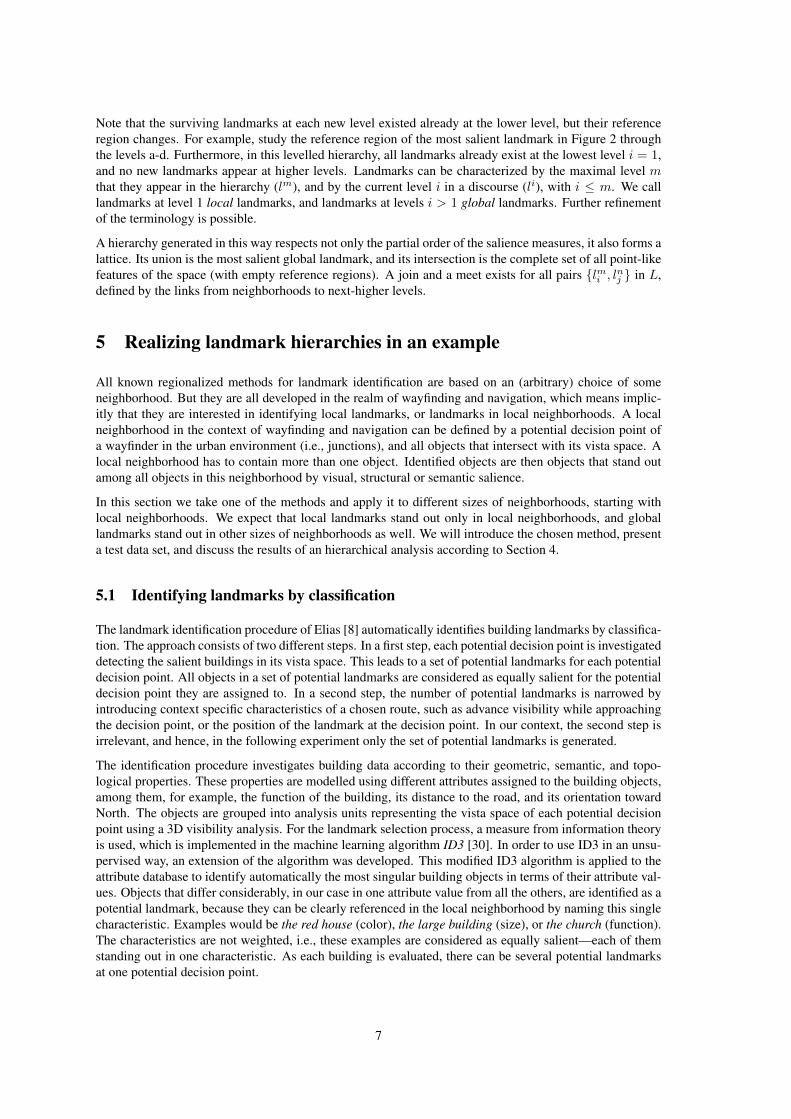
The method was applied to data of a portion of the city of Hannover, Germany. For an area of about 5 km2,the cadastral map, the topographic data set ATKIS, and a high-resolution 3D surface model generated fromairborne laser scanning were available. The extent of the area is shown in Figure 3.
Figure 3: The test area, a part of the city of Hannover, Germany (approximately 4× 4 km).
All junctions of the ATKIS road database were considered as potential decision points and used in theanalysis process. Thereby 283 junctions are available as test data. In this area, there are 2200 buildings onthe cadastral map given in form of polygons with additional thematic information. For each junction a 3Dvisibility analysis was conducted, using building polygons and the 3D surface model. For each junction,the building objects in its vista space establish its local neighborhood.
For each local neighborhood the data mining analysis process of the modified ID3 algorithm is applied.This way, for each junction a set of potential landmarks is identified. Altogether 868 building objects arechosen as potential landmarks, on average three for each junction. Because of the short distance betweenintersections in urban road networks, many buildings are visible from several junctions. Therefore, theanalysis procedure can select individual buildings for more than one junction as a potential landmark. Inthe test area we find buildings that are selected only once, but also a building that is selected at 48 junctionsas a potential landmark. Removing the redundant counts, the list of all potential landmarks in the test areaconsists only of 295 different building objects.
All potential landmarks are of equal salience. To determine a graduation of landmark salience, it is eithernecessary to take further route-specific aspects into account, such as advance visibility and quality, or thefrequency of selection of a specific building is assessed as a measure for the global salience of the object.We choose the second approach for its independence from individual routes and better relation to the generalexperience of a city. In this way, visibility is ranked higher among all characteristics.
8
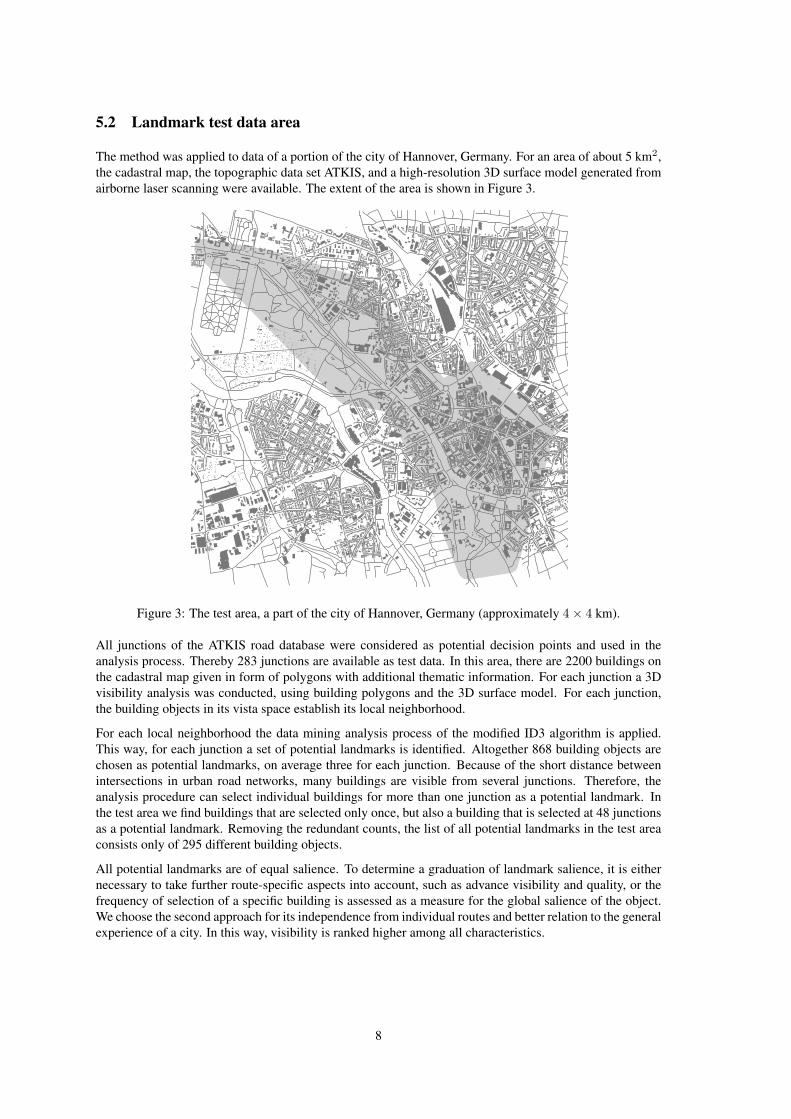
Table 1: Number of landmark objects in the seven hierarchy levels.Level 0 1 2 3 4 5 6 7Landmarks 295 95 32 11 4 3 2 1
5.3 Applying a Voronoi hierarchy onto the potential landmark selection
The introduced 295 different potential landmarks and their frequency of selection are used to establish alandmark Voronoi hierarchy. The potential landmark buildings are considered as Voronoi seeds in their ownlocal neighborhood. In Figure 4 they are represented by a dot marking their centroid coordinates, and thenumber indicates their frequency counter. The Voronoi cells for these points are calculated as base level(level 0 in the hierarchy; Fig. 4 left).
8
2
8
Figure 4: Voronoi cells with frequency counter. Left: base level, center: level 1, right: level 2.
So far, each potential landmark object is related to one Voronoi cell that represents the reference region ofthe landmark. For the next level in the hierarchy, the landmark selection is narrowed using the frequencyof selection as a measure of salience, following the procedure introduced in Section 4.3. Step by step, eachcell and its immediate neighbors are compared with each other, the cell object with the highest frequencycounter is chosen as the most salient one and stored as an object of the next higher level (see Fig. 4, centerand right). The procedure builds a new subset of landmarks with a Voronoi cell representing the referenceregion of the landmark at that level in the hierarchy. In this way, the number of objects decreases in eachlevel. The process terminates when one single landmark—the most global landmark for the investigatedarea—is left.
In the test area seven hierarchy levels starting from the base level have to be processed (see Fig. 5 andTab. 1). The single dot remained in level 7 represents the new town hall of Hannover, which is undoubtedlya prominent building in Hannover and one of its outstanding landmarks.
6 Evaluation of landmark hierarchies in context
Having derived the hierarchy of landmarks and their reference regions, the next question is how to make useof it. In this section we will investigate their use in granular route directions, which are route descriptionsdesigned for locals. Granular route directions are route descriptions, or rather descriptions of route desti-nations, that make deliberate use of spatial hierarchies. In particular we will show how the duality betweenthe landmarks and their reference regions allows for the evaluation of the spatial context of a route request.We will demonstrate how this duality is exploited in the selection of references to global or local landmarks.
6.1 Granular route directions with hierarchical spatial partitions
The construction of granular route directions based on hierarchical spatial partitions was previously ex-plored in Tomko and Winter [44, 45]. In short, filter rules select only referents that uniquely and unambigu-
9

Level 0 Level 1Level 2
Level 3Level 4 Level 5
Level 6Level 7
Figure 5: Base and higher hierarchy levels for the test area.
10

ously identify the destination of the route in a given context, i.e., for a given start location. In granular routedirections, the localization of the destination is the goal of the directions, with the expectation that localscan find their way as soon as they have localized the destination.
This means the selection of the route as such is left to the wayfinder, and their tacit knowledge of theenvironment. This is quite different to other work on hierarchic or otherwise efficiently structured route di-rections [e.g., 41, 48, 12, 9]. Furthermore, every reference in granular route directions is evaluated againstits information content, stating that it has to be relevant in the context of the route [35]. Altogether, gran-ular route directions fulfill the requirement of being referring expressions [4], or minimal unambiguousdescriptors of the referent, the route destination.
This requirement was accomplished by a recursive application of a few topological rules on hierarchicalspatial partitions [44, 45]. The initial step is searching for the highest hierarchy level in which the currentlocation and destination are still in a topological distance larger than 1. As the wayfinder progresses towardsthe destination, the location changes and consecutive references are generated with consideration of thischanged context. The rules are:
1. If current location or destination are not members of the hierarchy, throw exception.
2. If current location and destination are identical, stop.
3. If current location and destination are neighbors, stop and switch to turn-based directions.
4. If current location and destination have identical or neighboring direct superordinate elements, returna reference to the destination and stop.
5. If an element is a common ancestor of current location and destination, move down a level.
6. If an element is neighbor with an ancestor element of the current location, move down a level.
7. Otherwise: return a reference and continue.
Next we will examine these rules on the landmark hierarchy, with the working hypothesis that the samerules applied to the hierarchy of reference regions lead to referring expressions based on landmarks.
6.2 Granular route directions with landmark hierarchies
Neighborhood is the fundamental topological relation driving the selection of references in granular routedirections. Two areas are neighbors if they share a common boundary. Translated into our context, we saythat two landmarks are neighbors if their respective reference regions within the same hierarchical level areadjacent. Since the reference regions are modelled as Voronoi polygons, neighborhood is represented bytheir dual, the Delaunay triangulation. Relations between the levels of the hierarchy are retained in the listof associations from the ordering process of landmarks.
So, can we apply the above rules for the construction of granular route directions to landmarks? The ruleswere originally developed for tree-like hierarchical partitions. As we have seen, the landmark hierarchy doesnot form a tree. Furthermore, some landmarks are their own superordinate elements, due to the peculiaritiesof the generation of the hierarchy. Hence, the rules need an adaptation to be able to navigate in a hierarchywith multiple inheritances and multiple appearances of the same landmark.
Rules 1–4 apply to both hierarchies equally. The application of the Rules 5 and 6 to the hierarchy oflandmarks has, however, several shortcomings:
• The reference is always made to the landmark, and not to its reference area. The identity of thelandmark is unique even if its reference area changes across levels. Thus, it is possible that a referenceis made to a landmark that at a higher hierarchical level is an ancestor of both the current locationand the destination. Rule 5 is therefore irrelevant.
11

• It is impossible to test the neighborhood relation between the reference regions of landmarks with thedistance of hierarchical levels greater than 1. If the difference is one hierarchical level, this test can bedone partially through the association information. Beyond this, there is no conceptual grounding ofthe neighborhood relation between point-like landmarks, even if spatial analysis can be done betweenthe respective reference regions.
A restricted set of rules, dealing with these shortcomings, produces granular route directions with excessiveinformation, mostly in the form of redundant references to the same landmark. Furthermore, the algorithmis still not ready to deal with multiple ancestors of an element. This means that, at any level of the hierarchy,the set of possible referents is not restricted to one landmark.
Hence, we propose a further refined set of rules, enriched by mechanisms to deal with redundant referents inthe resulting route directions, as well as with the selection among multiple possible referents. We proposetwo new rules for the construction of landmark-based granular route directions:
1. Among possible referents, priority is given to the referents along the route. If multiple landmarkssatisfy this condition, the landmark closest to the destination is selected.
2. If a landmark is referred to multiple times, remove all but one reference.
This means basically that in the context of landmark-based granular route directions topological distance isnot the only rule that may apply. The consideration of the route context is a plausible mechanism to selectamong multiple referents, especially at finer levels of granularity.
In our implementation, a route is specified as a set of local reference regions. This route is never com-municated to the wayfinder. It provides, however, the spatial context for the identification of consecutivereferences.
6.3 Test of landmark-based granular route directions
The modified rules were implemented in the functional programming language Haskell, and applied to theexample of the City of Hannover (Section 5). We will describe the process of identification of the referentsfor a route from the University of Hannover to the State Opera (Fig. 6). This route was chosen from a mapand intersected with the Voronoi partition. For clarity and brevity, we restrict our example to hierarchylevels 2 and above, abandoning the large set of local landmarks.
In the figure, the university at level 2 is labelled h2 H097TLK, and the destination, the opera, is labelledh2 H01FM8E. The complete route at this level 2 is defined by a sequence of reference regions:
r o u t e = [ h2 H097TLK , h2 H063YJC , h2 H074YH2 , h2 H03PO3Z ,h2 H04SBR1 , h2 H01BHXG , h2 H01P2HN , h2 H04PTS0 , h2 H01FM8E ]
This route cuts across the city and crosses the reference regions of several global landmarks. It does notmean that the wayfinders reach those landmarks, but merely that while proceeding towards the destination,they enter their reference regions. Applying the rules for granular route directions generate the followingdescription:
d i r e c t i o n s = [H06Y0NB , H03NG5F , H04PTS0 , H01FM8E]
Note the missing prefixes for hierarchical levels. The reference is made to the landmark as such, not toits specific reference regions. In this case, the destination is found in the proximity of the first landmarkspecified, the global landmark H06Y0NB (Hannover town hall). The context of the route is restrictedto this area, and a consecutive reference of finer granularity is provided (H03NG5F). In this manner, weproceed from general references (landmarks with reference regions covering major parts of the city) tomore and more local landmarks. References provided may have no spatial overlap with the route as such,but they provide a description of the destination from the approaching direction of the wayfinder. The twoconsecutive references H03NG5F and H04PTS0 are filled in at consecutive steps of the algorithm through
12

Figure 6: A route (highlighted in gray) between the University of Hannover (h2 H097TLK) and the StateOpera (h2 H01FM8E), composed of level 2 reference regions. Referents identified for granular route di-rections are labelled.
the same process (Fig. 7). The route description is completed with the reference to the destination itself(H01FM8E).
We can interpret these results as the following route description generated by a human:
A:“Where is the show this evening?”B:“It is in the State Opera, the building next to the Kropcke, not far from the town hall and the Maritim-Hotel building.”
In this example we have made additional use of spatial context. Every point within a reference regionis considered to be within the spatial context of the respective landmark, and is thus next to it. This isclose to the tectonic plates hypothesis [3]. The association of arbitrary points in space with their referencelandmarks can change between consecutive granularity levels.
The result is a plausible granular route direction from the university to the opera. Consultation with a local
Figure 7: Two consecutive references to landmarks H03NG5F (level 4) and H04PTS0 (level 3).
13
expert shows that, depending on the spatial context of the chosen route, our destination description presentsreferents likely to be chosen by a local. Only the reference to the Maritim-Hotel was felt to be excessive.The reference was made due to the high visual salience of the hotel, which in this case seems not to matchwith prominence. This observation indicates also that the distinctions of salience in the top levels of thehierarchy might be not pragmatic.
Contexts other than spatial context, such as mode of transport, make a difference, but are not consideredin this paper. In the case of a pedestrian, for example, a local would very likely refer directly to the opera,as the building as such is prominent for every local. In the case of a car driver, though, the route from theuniversity to the opera is lengthy and complex (the opera is in a pedestrian zone). Hence, the referencesprovided by our model show a granularity likely to be used by locals for car drivers.
Let us consider also the reverse route from the opera to the Institute for Chemistry on the university campus.It is one of the buildings adjacent to the very prominent main building of the university. The resultingdirections consist of only two referents: the main building and the building of the Institute for Chemistry.This result again was assessed by a local expert as a plausible result.
The simple combination of the topological distance and the context of the route provided a set of rulesenabling the construction of granular route directions. Based on a hierarchical ranking of landmarks, theresults provide plausible directions for locals. Topology and the route context can be further enhanced byother considerations, to provide a better match with those provided by humans in specific situations.
7 Conclusions
The ultimate goal of our research is to design spatial information services for everyday decisions thatbetter reflect the way people communicate about spatial information. We believe that services reflectinghuman spatial communication are more easily accepted, because they require less learning, lower cognitiveworkload, and lower memory load (Tomko and Winter [43], for example, argue that human granular routedirections are designed to be kept in short term memory). In this way service users should find spatialdescriptions more intuitive, their comprehension easier, and hence, feel more satisfied or more comfortablein using these descriptions as oppose to descriptions from actual services.
In this paper we have taken an engineering approach to reflect in a formal model a process known fromhuman spatial cognition: the hierarchical representation, reasoning and communication of spatial informa-tion. In particular we focus on formal models for landmarks and their use in route or place descriptions.These models enable us to use geographical databases to derive route descriptions that are close to humanones, introducing from context concepts such as near to. In these models spatial context is the key for theselection of references.
We have presented a model to build hierarchies of landmarks from salience, extending one of the modelsto automatically identify landmarks. With a ranking based on visibility, we even found a cognitive relevantranking criterion. This model was tested for a part of the city of Hannover, Germany, and showed reasonablebehavior. We have then taken a model to generate granular route directions from hierarchical partitions, andmodified it for the particularities of the landmark hierarchies. This model was tested on the same datasetand also showed reasonable behavior. Hence, we could prove our hypothesis.
Refinements and more extensive tests of these models are possible. For example, ranking based on visibilitydid not take into account the distance, or the proportions in the field of view, and ranking factors other thanvisibility could also be investigated. Any change of the ranking method influences the resulting hierarchy.Another example is the method to identify the basic set of landmarks. It currently applies equal weights tothe different salience factors; a different weighting would lead to different choices of landmarks, and hence,different hierarchies. Equally, the rules on landmark hierarchies for granular route directions can be refinedand extended. The current set of rules was tested on the dataset of Hannover, but with more datasets onecould find special cases not yet considered.
Another refinement concerns the partition of reference regions. Especially in urban space, taking barriersinto account should constrain the partitioning process. This includes the preservation of boundaries acrosshierarchical levels.
14
Having solved the problem of hierarchically ordering landmarks is an essential condition for hierarchicroute or place descriptions. However, landmarks are only one type of element relevant for these descrip-tions. Other elements of the city, such as places, paths, barriers, and districts [21], are also experienced bypeople, form parts of their cognitive spatial representations, and hence, have hierarchical cognitive orderas well. While some work on the other elements is already done [45] or underway, this article contributesthe hierarchies of landmarks. An open question for future work is how to link these hierarchies in thegeneration of route or place descriptions.
We also expect more subtle links between different hierarchies. For example, in the current approach alllandmarks are considered point-like and of the same type (building), and accordingly, all appear at the samelocal level. If we allow for other types of landmarks, then landmarks can appear at higher levels for thefirst time, a property of granularity. For example, the site of the world exhibition in Hannover (EXPO2000)might be considered as a landmark, but consists of multiple buildings. Hence, a landmark EXPO2000 doesnot exist at the local level of buildings. Therefore, the integration of landmarks with other types of elementsof the city is an interesting remaining question. Relationships to scale space [16, 19] and to map scalehierarchies [39] are expected.
Acknowledgements
Geodata by courtesy of National Mapping Agency of Lower Saxony, Germany (LGN).
References[1] Arampatzis, A., van Kreveld, M., Reinbacher, I., Jones, C. B., Vaid, S., Clough, P., Joho, H., Sander-
son, M., 2006. Web-Based Delineation of Imprecise Regions. Computers, Environment and UrbanSystems in press.
[2] Bateman, J., 1999. Using Aggregation for Selecting Content When Generating Referring Expressions.In: Proceedings of the 37th Annual Meeting of the Association for Computational Linguistics onComputational Linguistics. ACL, College Park, Maryland, pp. 127–134.
[3] Couclelis, H., Golledge, R. G., Tobler, W., 1987. Exploring the Anchorpoint Hypothesis of SpatialCognition. Journal of Environmental Psychology 7, 99–122.
[4] Dale, R., 1992. Generating Referring Expressions: Constructing Descriptions in a Domain of Objectsand Processes. MIT Press, Cambridge, Mass.
[5] Dale, R., Reiter, E., 1995. Computational Interpretations of the Gricean Maxims in the Generation ofReferring Expressions. Cognitive Science 19 (2), 233–263.
[6] Denis, M., 1997. The description of routes: A cognitive approach to the production of spatial dis-course. Current Psychology of Cognition 16 (4), 409–458.
[7] Elias, B., 2003. Extracting Landmarks with Data Mining Methods. In: Kuhn, W., Worboys, M. F.,Timpf, S. (Eds.), Spatial Information Theory. Vol. 2825 of Lecture Notes in Computer Science.Springer, Berlin, pp. 398–412.
[8] Elias, B., 2006. Extraktion von Landmarken fur die Navigation. Dissertation, University of Hannover,wissenschaftliche Arbeiten der Fachrichtung Geodasie und Geoinformatik der Universitat Hannover,Nr. 260.
[9] Elias, B., Sester, M., 2006. Incorporating landmarks with quality measures in routing procedures. In:Raubal, M., Miller, H. J., Frank, A. U., Goodchild, M. F. (Eds.), Geographic Information Science.Vol. 4197 of Lecture Notes in Computer Science. Springer, Berlin, pp. 65–80.
[10] Frank, A. U., Timpf, S., 1994. Multiple Representations for Cartographic Objects in a Multi-ScaleTree - An Intelligent Graphical Zoom. Computers and Graphics 18 (6), 823–829.
15

[11] Galler, I., 2002. Identifikation von Landmarks in 3D-Stadtmodellen. Diploma thesis, RheinischeFriedrich-Wilhelms-Universitt Bonn.
[12] Hansen, S., Richter, K.-F., Klippel, A., 2006. Landmarks in OpenLS: A Data Structure for CognitiveErgonomic Route Directions. In: Raubal, M., Miller, H. J., Frank, A. U., Goodchild, M. F. (Eds.),Geographic Information Science. Vol. 4197 of Lecture Notes in Computer Science. Springer, Berlin,pp. 128–144.
[13] Hirtle, S. C., Jonides, J., 1985. Evidence of Hierarchies in Cognitive Maps. Memory and Cognition13 (3), 208–217.
[14] Jarvella, R. J., Klein, W. (Eds.), 1982. Speech, Place, and Action. John Wiley & Sons, Chichester, NY.
[15] Klippel, A., Winter, S., 2005. Structural Salience of Landmarks for Route Directions. In: Cohn, A. G.,Mark, D. M. (Eds.), Spatial Information Theory. Vol. 3693 of Lecture Notes in Computer Science.Springer, Berlin, pp. 347–362.
[16] Koenderink, J. J., 1984. The Structure of Images. Biological Cybernetics 50 (5), 363–370.
[17] Kuipers, B., 1998. A Hierarchy of Qualitative Representations for Space. In: Freksa, C., Habel, C.,Wender, K. F. (Eds.), Spatial Cognition. Vol. 1404 of Lecture Notes in Artificial Intelligence. Springer,Berlin, pp. 337–350.
[18] Lang, D., Winter, S., Frank, A. U., 2001. Neighborhood Relations between Fields with Applicationsto Cellular Networks. GeoInformatica 5 (2), 127–144.
[19] Lindeberg, T., 1994. Scale-Space Theory in Computer Vision. Kluwer Academic Publishers, Dor-drecht.
[20] Lovelace, K. L., Hegarty, M., Montello, D. R., 1999. Elements of Good Route Directions in Familiarand Unfamiliar Environments. In: Freksa, C., Mark, D. M. (Eds.), Spatial Information Theory. Vol.1661 of Lecture Notes in Computer Science. Springer, Berlin, pp. 65–82.
[21] Lynch, K., 1960. The Image of the City. MIT Press, Cambridge.
[22] Montello, D. R., 1993. Scale and Multiple Psychologies of Space. In: Frank, A. U., Campari, I.(Eds.), Spatial Information Theory. Vol. 716 of Lecture Notes in Computer Science. Springer, Berlin,pp. 312–321.
[23] Montello, D. R., Goodchild, M. F., Gottsegen, J., Fohl, P., 2003. Where’s Downtown? BehavioralMethods for Determining Referents of Vague Spatial Queries. Spatial Cognition and Computation3 (2&3), 185–204.
[24] Moulin, B., Kettani, D., 1999. Route generation and description using the notions of object’s influencearea and spatial conceptual map. Spatial Cognition and Computation 1 (3), 227–259.
[25] Okabe, A., Boots, B., Sugihara, K., Chiu, S. N., 2000. Spatial Tesselations: Concepts and Applicationsof Voronoi Diagrams, second edition Edition. John Wiley & Sons, Chichester, United Kingdom.
[26] Paraboni, I., Deemter, K. v., 2002. Generating Easy References: The Case of Document Deixis. In:Second International Conference on Natural Language Generation (INLG 2002). New York, USA, pp.113–119.
[27] Plumert, J. M., Carswell, C., DeVet, K., Ihrig, D., 1995. The Content and Organization of Communi-cation about Object Locations. Journal of Memory and Language 34, 477–498.
[28] Presson, C. C., Montello, D. R., 1988. Points of Reference in Spatial Cognition: Stalking the ElusiveLandmark. British Journal of Developmental Psychology 6, 378–381.
[29] Purves, R. S., Clough, P., Joho, H., 2005. Identifying Imprecise Regions for Geographic InformationRetrieval Using the Web. In: Billen, R., Drummond, J. E., Forrest, D., Joo, E. (Eds.), GIS ResearchUK. Glasgow, UK, pp. 313–318.
16

[30] Quinlan, J. R., 1986. Induction of Decision Trees. Machine Learning 1 (1), 81–106.
[31] Raubal, M., Winter, S., 2002. Enriching Wayfinding Instructions with Local Landmarks. In: Egen-hofer, M. J., Mark, D. M. (Eds.), Geographic Information Science. Vol. 2478 of Lecture Notes inComputer Science. Springer, Berlin, pp. 243–259.
[32] Schelling, T. C., 1960. The Strategy of Conflict. Harvard University Press, Cambridge, Mass.
[33] Shanon, B., 1983. Answers to Where-Questions. Discourse Processes 6, 319–352.
[34] Sorrows, M. E., Hirtle, S. C., 1999. The Nature of Landmarks for Real and Electronic Spaces. In:Freksa, C., Mark, D. M. (Eds.), Spatial Information Theory. Vol. 1661 of Lecture Notes in ComputerScience. Springer, Berlin, pp. 37–50.
[35] Sperber, D., Wilson, D., 1986. Relevance – Communication and Cognition. Basil Blackwell, Oxford.
[36] Stevens, A., Coupe, P., 1978. Distortions in Judged Spatial Relations. Cognitive Psychology 10 (4),422–437.
[37] Strohecker, C., 2000. Cognitive Zoom: From Object to Path and Back Again. In: Freksa, C., Brauer,W., Habel, C., Wender, K. F. (Eds.), Spatial Cognition II. Vol. 1849 of Lecture Notes in ArtificialIntelligence. Springer, Berlin, pp. 1–15.
[38] Tezuka, T., Yokota, Y., Iwaihara, M., Tanaka, K., 2004. Extraction of Cognitively-Significant PlaceNames and Regions from Web-Based Physical Proximity Co-occurrences. In: Zhou, X., Su, S., Papa-zoglou, M. P., Orlowska, M. E., Jeffrey, K. G. (Eds.), Web Information Systems (WISE 2004). Vol.3306 of Lecture Notes in Computer Science. Springer, Berlin, pp. 113–124.
[39] Timpf, S., 1998. Hierarchical Structures in Map Series. Ph.d. thesis, Technical University Vienna.
[40] Timpf, S., Frank, A. U., 1997. Using Hierarchical Spatial Data Structures for Hierarchical SpatialReasoning. In: Hirtle, S. C., Frank, A. U. (Eds.), Spatial Information Theory (COSIT ’97). Vol. 1329of Lecture Notes in Computer Science. Springer, Berlin, pp. 69–83.
[41] Timpf, S., Kuhn, W., 2003. Granularity Transformations in Wayfinding. In: Freksa, C., Brauer, W.,Habel, C., Wender, K. F. (Eds.), Spatial Cognition III. Vol. 2685 of Lecture Notes in Artificial Intelli-gence. Springer, Heidelberg, pp. 77 – 88.
[42] Timpf, S., Volta, G. S., Pollock, D. W., Frank, A. U., Egenhofer, M. J., 1992. A Conceptual Modelof Wayfinding Using Multiple Levels of Abstraction. In: Frank, A. U., Campari, I., Formentini, U.(Eds.), Theories and Methods of Spatio-Temporal Reasoning in Geographic Space. Vol. 639 of LectureNotes in Computer Science. Springer, Berlin, pp. 348–367.
[43] Tomko, M., Winter, S., 2006. Considerations for Efficient Communication of Route Directions. In:Cartwright, W., Yoshida, H., Andrienko, G. (Eds.), ISPRS Workshop on Spatial Data Communicationand Visualization. ISPRS, Vienna, Austria.
[44] Tomko, M., Winter, S., 2006. Initial Entity Identification for Granular Route Directions. In: Kainz,W., Riedl, A., Elmes, G. (Eds.), Progress in Spatial Data Handling. Springer, Vienna, Austria, pp.43–60.
[45] Tomko, M., Winter, S., 2006. Recursive Construction of Granular Route Directions. Journal of SpatialScience 51 (1), 101–115.
[46] Tsuchiya, P. F., 1988. The Landmark Hierarchy: A New Hierarchy for Routing in Very Large Net-works. ACM SIGCOMM Computer Communication Review 18 (4), 35–42.
[47] Winter, S., Tomko, M., 2006. Translating the Web Semantics of Georeferences. In: Taniar, D., Ra-hayu, J. W. (Eds.), Web Semantics & Ontology. Idea Publishing, Hershey, PA, pp. 297–333.
[48] Wuersch, M., Caduff, D., 2005. Refined Route Instructions Using Topological Stages of Closeness.In: Li, K.-J., Vangenot, C. (Eds.), Web and Wireless Geographical Information Systems. Vol. 3833 ofLecture Notes in Computer Science. Springer, Berlin, pp. 31–41.
17