Embed Size (px)
Citation preview
Landsat program 1
Landsat program
Interview of Jim Irons - LDCM Project Scientist – NASA Goddard Space FlightCenter.
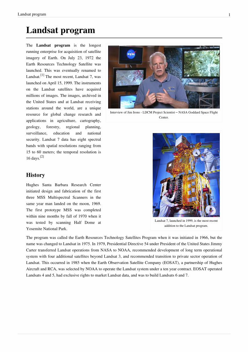
Landsat 7, launched in 1999, is the most recentaddition to the Landsat program.
The Landsat program is the longestrunning enterprise for acquisition of satelliteimagery of Earth. On July 23, 1972 theEarth Resources Technology Satellite waslaunched. This was eventually renamed toLandsat.[1] The most recent, Landsat 7, waslaunched on April 15, 1999. The instrumentson the Landsat satellites have acquiredmillions of images. The images, archived inthe United States and at Landsat receivingstations around the world, are a uniqueresource for global change research andapplications in agriculture, cartography,geology, forestry, regional planning,surveillance, education and nationalsecurity. Landsat 7 data has eight spectralbands with spatial resolutions ranging from15 to 60 meters; the temporal resolution is16 days.[2]
History
Hughes Santa Barbara Research Centerinitiated design and fabrication of the firstthree MSS Multispectral Scanners in thesame year man landed on the moon, 1969.The first prototype MSS was completedwithin nine months by fall of 1970 when itwas tested by scanning Half Dome atYosemite National Park.
The program was called the Earth Resources Technology Satellites Program when it was initiated in 1966, but thename was changed to Landsat in 1975. In 1979, Presidential Directive 54 under President of the United States JimmyCarter transferred Landsat operations from NASA to NOAA, recommended development of long term operationalsystem with four additional satellites beyond Landsat 3, and recommended transition to private sector operation ofLandsat. This occurred in 1985 when the Earth Observation Satellite Company (EOSAT), a partnership of HughesAircraft and RCA, was selected by NOAA to operate the Landsat system under a ten year contract. EOSAT operatedLandsats 4 and 5, had exclusive rights to market Landsat data, and was to build Landsats 6 and 7.

Landsat program 2
A simulated-color satellite image of Kolkata taken onNASA's Landsat 7 satellite.
In 1989, this transition had not been fully completed whenNOAA's funding for the Landsat program was due to run out(NOAA had not requested any funding, and Congress hadappropriated only six months of funding for the fiscal year)[3] andNOAA directed that Landsats 4 and 5 be shut down.[4] The head ofthe newly formed National Space Council, Vice President DanQuayle, noted the situation and arranged emergency funding thatallowed the program to continue with the data archives intact.[3][4][5][6]
Again in 1990 and 1991, Congress provided only half of the year'sfunding to NOAA, requesting that agencies that used Landsat dataprovide the funding for the other six months of the upcomingyear.[3] In 1992, various efforts were made to procure funding forfollow on Landsats and continued operations, but by the end of theyear EOSAT ceased processing Landsat data. Landsat 6 wasfinally launched on October 5, 1993, but was lost in a launch failure. Processing of Landsat 4 and 5 data wasresumed by EOSAT in 1994. NASA finally launched Landsat 7 on April 15, 1999.
The value of the Landsat program was recognized by Congress in October 1992 when it passed the Land RemoteSensing Policy Act (Public Law 102-555) authorizing the procurement of Landsat 7 and assuring the continuedavailability of Landsat digital data and images, at the lowest possible cost, to traditional and new users of the data.
Satellite chronology• Landsat 1 (originally named Earth Resources Technology Satellite 1): launched July 23, 1972, terminated
operations January 6, 1978• Landsat 2: launched January 22, 1975, terminated January 22, 1981• Landsat 3: launched March 5, 1978, terminated March 31, 1983• Landsat 4: launched July 16, 1982, terminated 1993• Landsat 5: launched March 1, 1984, still functioning.[7][8] but severe problems since Nov. 2011[9]
• Landsat 6: launched October 5, 1993, failed to reach orbit• Landsat 7: launched April 15, 1999, still functioning, but with faulty scan line corrector (May 2003) [10]

Landsat program 3
Technical details
False-color composite (processed to simulate true color) image of theisland of Hawaii was constructed from data gathered between 1999
and 2001 by the Enhanced Thematic Mapper plus (ETM+)instrument, flying aboard the Landsat 7 satellite. The Landsat datawere processed by the National Oceanographic and AtmosphericAdministration (NOAA) to develop a landcover map. The black
areas on the island (in this scene) that resemble a pair of sun-bakedpalm fronds are hardened lava flows formed by the active Mauna
Loa Volcano. Just to the north of Mauna Loa is the dormant grayishMauna Kea Volcano, which hasn’t erupted in an estimated 3,500years. A thin greyish plume of smoke is visible near the island’s
southeastern shore, rising from Kilauea—the most active volcano onEarth. Heavy rainfall and fertile volcanic soil have given rise to
Hawaii’s lush tropical forests, which appear as solid dark green areasin the image. The light green, patchy areas near the coasts are likely
sugar cane plantations, pineapple farms, and human settlements.
The Multispectral Scanner had a 9" fused silicadinner-plate mirror epoxy bonded to three invar tangentbars mounted to base of a Ni/Au brazed Invar frame ina serreuire truss that was arranged with four"Hobbs-Links" (conceived by Dr. Gregg Hobbs)crossing at mid truss. This construct ensured thesecondary mirror would simply oscillate about theprimary optic axis to maintain focus despite vibrationinherent from the 14-inch (unknown operator:u'strong' mm) Be scan mirror. This engineeringsolution allowed the US to develop LANDSAT at leastfive years ahead of French SPOT which first used CCDarrays to stare without need for a scanner.
The MSS FPA, or Focal Plane Array consisted of 24square optical fibers extruded down to .0002"squarefiber tips in a 4x6 array to be scanned across theNimbus spacecraft path in a +/-6 degree scan as thesatellite was in a 10:30 polar orbit, hence it had to belaunched from Vandenberg AFB. The fiber opticbundle was embedded in a fiber optic plate to beterminated at a relay optic device that transmitted fiberend signal on into six photodiodes and 18photomultiplier tubes that were arrayed across a0.30-inch (unknown operator: u'strong' mm) thickaluminum tool plate, with sensor weight balanced vsthe 9-inch (unknown operator: u'strong' mm)telescope on opposite side. This main plate wasassembled on a frame, then attached to thesilver-loaded magnesium housing with helicoilfasteners.
Key to MSS success was the scan monitor mounted on the underbelly of the Mg housing. It consisted of a diodesource and sensor mounted at ends of four flat mirrors that were tilted so that it took 14 bounces for a beam to reflectlength of the three mirrors from source to sender striking Be scan mirror seven times as it reflected seven times offthe flat mirrors. It only sensed three positions, both ends of scan and the mid scan, but that was all that was requiredto determine where MSS was pointed and electronics scanning could be calibrated to display a map.
Future
The Landsat Data Continuity Mission (LDCM),[11] scheduled to be launched February 2013, will be the next satellitein the Landsat series. It is being launched on an Atlas V 401 from Vandenberg Air Force Base by the LaunchServices Program. It will continue to obtain valuable data and imagery to be used in agriculture, education, business,science, and government. The new satellite is being assembled in Arizona by Orbital Sciences Corporation.[12]
Landsat program 4
- Overview of the Thermal Infrared Sensor (TIRS), one ofthe instruments on the Landsat Data Continuity Mission (LDCM).
- A timelapse of the Thermal Infrared Sensor (TIRS)instrument for the Landsat Data Continuity Mission (LDCM) being cleaned, bagged, and packed to ship to OrbitalSciences Corp, where TIRS will be integrated with the spacecraft.
References[1] Short, N.M.. "The LANDSAT Tutorial Workbook: Basics of Satellite Remote Sensing" (http:/ / hdl. handle. net/ 2060/ 19830002188). NASA
Reference Publication 1078. NASA. . Retrieved 20 September 2011.[2] The Landsat Program - Technical Details (http:/ / landsat. gsfc. nasa. gov/ about/ L7_td. html)[3] Greenberg, Joel S.; Hertzfeld, Henry (1992). Space Economics. AIAA (American Institute of Aeronautics & Ast). p. 372.
ISBN 1-56347-042-X.[4] United Press International (1989-03-03). "Govt. pulls the plug on two satellites, threatening jobs" (http:/ / news. google. com/
newspapers?id=EjkQAAAAIBAJ& sjid=G48DAAAAIBAJ& dq=satellite congress landsat& pg=3918,6412636). Ellensburg Daily Record. .Retrieved 2010-05-19.
[5] Associated Press (1989-03-07). "Quayle backs satellite program" (http:/ / news. google. com/ newspapers?id=7L0gAAAAIBAJ&sjid=tGkFAAAAIBAJ& dq=satellite quayle& pg=1441,798034). The Lewiston Journal. . Retrieved 2010-05-19.
[6] John Noble Wilford (1989-03-17). "U.S. Halts Plan to Turn Off the Landsat Satellites" (http:/ / www. nytimes. com/ 1989/ 03/ 17/ us/us-halts-plan-to-turn-off-the-landsat-satellites. html?pagewanted=1). The New York Times. . Retrieved 2010-05-19.
[7] Universe Today » Landsat 5 Reaches 20 Years in Space (http:/ / www. universetoday. com/ am/ publish/ landsat_5_20_years. html?432004)[8] 20 Years of Landsat 5 (http:/ / earth. esa. int/ showcase/ landsat/ )[9] (http:/ / landsat. usgs. gov/ mission_headlines2012. php)[10] The Landsat Program (http:/ / landsat. gsfc. nasa. gov/ )[11] Landsat Data Continuity Mission (LDCM) (http:/ / ldcm. nasa. gov)[12] "Landsat Data Continuity Mission" (http:/ / ldcm. gsfc. nasa. gov/ ). NASA. .
Landsat program 5
External links• Landsat homepage (http:/ / landsat. usgs. gov/ )• Landsat NASA homepage (http:/ / landsat. gsfc. nasa. gov/ )• Landsat.org Home Page (http:/ / landsat. org/ )• Works by Landsat (http:/ / www. gutenberg. org/ author/ U. S. _Landsat_Pathfinder) at Project Gutenberg
•• Landsat picture of Washington, D. C.• (Free) Landsat imagery from GLOVIS (http:/ / glovis. usgs. gov/ ) and Global Land Cover Facility (http:/ / ftp.
glcf. umd. edu/ index. shtml)• Atlogis Maps (http:/ / maps. atlogis. com/ webmapping/ htdocs/ index. html) and Atlogis Meta-Maps (http:/ /
www. atlogis. com/ metamaps. html): Online-Viewer for Landsat 5 and Landsat 7 Natural Color Mosaic fromAtlogis (http:/ / www. atlogis. com). Meta-Maps (http:/ / www. atlogis. com/ metamaps. html) includes Google,MSN and Yahoo Maps.
• (Free) Landsat mosaic imagery from the WELD (http:/ / landsat. usgs. gov/ WELD. php) project.• Landsat imagery for circa 1975, 1990 and 2000 visualised in Google Earth (required GE installed) (http:/ / www.
ambiotek. com/ terrascope)
Article Sources and Contributors 6
Article Sources and ContributorsLandsat program Source: http://en.wikipedia.org/w/index.php?oldid=503915882 Contributors: A5b, Acha11, Alecperkins, Andrewpmk, Antandrus, Arch dude, Archaen sax, Ashley Pomeroy,BigDukeSix, Bryan Derksen, Bumbulski, Caleystaxi, CaptainKlepto, ChiZeroOne, ChrisGualtieri, Discospinster, DocWatson42, Dravecky, Dtrebbien, Edward, Engineer Bob, Epbr123, Fremsley,Fuzheado, Geologicharka, Georick49, Gis-team, Ground Zero, Hujev, Indukom, JTN, Jiang, Jim.henderson, John, Keith Edkins, Krashlandon, Lightmouse, MBK004, MER-C, Malhonen, MarkYen, Martin451, Materialscientist, Miss Madeline, Moverton, Mrdice, Msiebuhr, Mwtoews, Nasa-verve, Ohms law, Originalwana, Orlady, Pengo, Piano non troppo, Pstakem, Ronduck, SGGH,STHayden, Sardanaphalus, Scriberius, Sdsds, Seventypercent, ShapedNoise, Shenstar, SincereGuy, Sohowsgoing, Speculos, Spikebrennan, Stepa, Tangentidea, Tdrss, Tom, Uncle Dick, Warut,Wavelength, Xlicolts613, Zelytic, 73 anonymous edits
Image Sources, Licenses and ContributorsFile:Landsat 40th.ogv Source: http://en.wikipedia.org/w/index.php?title=File:Landsat_40th.ogv License: Public Domain Contributors: NASA/Goddard Space Flight CenterImage:Landsat7photo.jpg Source: http://en.wikipedia.org/w/index.php?title=File:Landsat7photo.jpg License: Public Domain Contributors: NASAImage:Large Kolkata Landsat.jpg Source: http://en.wikipedia.org/w/index.php?title=File:Large_Kolkata_Landsat.jpg License: Public Domain Contributors: NASAImage:Island of Hawai'i - Landsat mosaic.jpg Source: http://en.wikipedia.org/w/index.php?title=File:Island_of_Hawai'i_-_Landsat_mosaic.jpg License: Public Domain Contributors: HawaiiLand Cover Analysis project, NOAA Coastal Services CenterImage:Overview of the Thermal Infrared Sensor.ogv Source: http://en.wikipedia.org/w/index.php?title=File:Overview_of_the_Thermal_Infrared_Sensor.ogv License: Public Domain Contributors: NASA/Goddard Space Flight CenterImage:Timelapse of TIRS for LDCM.ogv Source: http://en.wikipedia.org/w/index.php?title=File:Timelapse_of_TIRS_for_LDCM.ogv License: Public Domain Contributors: NASA/GoddardSpace Flight Center
LicenseCreative Commons Attribution-Share Alike 3.0 Unported//creativecommons.org/licenses/by-sa/3.0/