Embed Size (px)
Citation preview
SOUTH WEST VICTORIA LANDSCAPE ASSESSMENT STUDY
Landscape Character Types & Areas Analysis Papers
JUNE 2013
2
DPCD South West Victoria Landscape Assessment Study | ChArACter ASSeSSment
© 2013
Logo is at twice the size for the footer
The South West Victoria Landscape Assessment Study assesses the character and significance of the landscape, leading to the preparation of planning scheme policy and guidance to ensure its protection and management into the future.
The study is being prepared in four stages:
▪ Desktop analysis & research ▪ Landscape character assessment ▪ Landscape significance assessment ▪ Final recommendations
Landscape Character AssessmentThis report compiles the initial findings of the landscape character analysis of the study area.
Landscape character is defined as ‘the interplay of geology, topography, vegetation, water bodies and other natural features, combined with the effects of land use and built development, which makes one landscape different from another.’
The study area, shown on the map opposite, has been divided into eight landscape Character Types based on broad areas of common physical, environmental and cultural characteristics.
At a local level, each Character Type has been further divided into landscape Character Areas, which are separate geographical units within the same Character Type, or areas across which local conditions, such as the landscape features, or the pattern of viewing, vary.
A list of the Character Types and Character Areas can be found on page 6 and their location is shown in Figure 2 on page 7.
SoUTh WEST LANdSCAPE ASSESSmENT STUdy: ChArACTEr ASSESSmENT
A professional assessment has underpinned the determination of landscape character, focussing on objective distinctions between Character Types, and the relationship between landscape Character Types and their constituent Character Areas.
In brief, the Character Types and Areas were identified through a study of key landscape character elements including landform, waterform, vegetation and land use and built form, together with a detailed field survey.
how to read this reportThis report includes papers for the eight Character Types, followed by papers for their respective Character Areas.
The Character Type papers provide a detailed overview of each Character Type and include:
▪ Overview - Details of the area’s location, key features and landscape characteristics
▪ Pattern of Viewing - Details of patterns of viewing through the area
▪ Landscape Values - Details of places, views and features that are valued in the area
▪ Change in the Landscape - A description of the how the landscape in the area has changed
▪ Future Landscape Character Directions - A description of the vision for the area and threats and opportunities that will impact upon the vision
▪ Landscape Protection & Management - A list of existing Planning Scheme policies and controls that protect the area and objectives and guidelines for the management of the landscape
The Character Area papers provide more detail at a local level and include:
▪ Overview - Details of the area’s location, key features, and key settlements
▪ Pattern of Viewing - Details of patterns of viewing through the area
▪ Landscape Values - Details of places, views and features that are valued in the area
▪ Landscape Protection & Management - A list of existing Planning Scheme policies and controls that protect the area and objectives and guidelines for the management of the landscape

Figure 1 Context map
State of VictoriaStudy Area
3
DPCD South West Victoria Landscape Assessment Study | ChArACter ASSeSSment
© 2013
Logo is at twice the size for the footer

COLAC OTWAY
GOLDEN PLAINS
SURF COAST
CORANGAMITE
HEPBURN
GREATER GEELONG
QUEENSCLIFFE
PYRENEES
MOORABOOL
BALLARAT
WARRNAMBOOL
MOYNE
NORTHERNGRAMPIANS
SOUTHERN GRAMPIANSARARAT
GLENELG
WESTWIMMERA
HORSHAM
Study areaAreas covered by existing landscape assessment studiesStudy sub-areasMunicipal boundaries
STUDY AREA
4
DPCD South West Victoria Landscape Assessment Study | ChArACter ASSeSSment
© 2013
Logo is at twice the size for the footer
This study builds on landscape assessment work that is underway or has already been completed in the surrounding area as shown on the map right.
Existing studies include:
▪ Great Ocean Road Region Landscape Assessment Study (2003)
▪ Coastal Spaces Landscape Assessment Study (2006) ▪ Landscape Assessment North of the Princes Highway,
Surf Coast Shire (2007) ▪ Draft Warrnambool Coastal Landscape Review (2009) ▪ Southern Grampians Significant Landscape
Assessment (underway)
PrEvioUS STUdiES
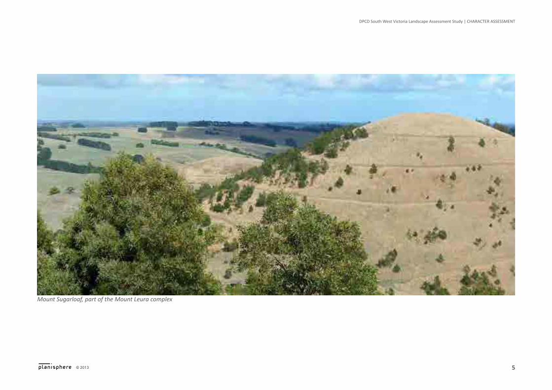
Mount Sugarloaf, part of the Mount Leura complex
5
DPCD South West Victoria Landscape Assessment Study | ChArACter ASSeSSment
© 2013
Logo is at twice the size for the footer

6
DPCD South West Victoria Landscape Assessment Study | ChArACter ASSeSSment
© 2013
Logo is at twice the size for the footer
1 The WesTern VoLCaniC PLain
1.1 Paddocks & Cones
1.2 Large Shallow & Deep Crater Lakes
1.3 Volcanic Agricultural
1.4 Stony Rises & Lava Flows
1.5 Lakeside Stony Rises
1.6 Volcanic Lakes & Swamps
1.7 Cones & Mines
1.8 Volcanic Ranges
1.9 Vegetated Volcanic Plains
1.10 Partially Wooded Agricultural
1.11 Winchelsea Western Plains
2 The UPLanDs
2.1 Forested Hills
2.2 Residential Forest Edges
2.3 Cleared Pastures
2.4 Fertile Valleys
ChArACTEr ArEAS & TyPES
2.5 Plateaus & Gorges
2.6 Brisbane Ranges
2.7 You Yangs
2.8 Creswick Forested Uplands
2.9 Rural Living
2.10 Valley Views
2.11 Central Forested Uplands
2.12 Island Uplands
2.13 Eastern Pyrenees
2.14 Southern Pyrenees Rises
2.15 Upland Interface
2.16 Mount Cole Creek
3 GoLDFieLDs
3.1 Agricultural Plateaus
3.2 Goldfields Forests
3.3 Central Goldfields
3.4 Ararat Hills
4 The roLLinG TabLeLanDs
4.1 Eastern Tablelands
4.2 Open Hills & Valleys
4.3 Vegetated Tablelands
5 The WiMMera PLains
5.1 Lakes & Wetlands
5.2 Cleared Wimmera Catchment
5.3 Lake Lonsdale & Surrounds
5.4 Mount Arapiles
6 GraMPians (GariWerD) & sUrroUnDs
6.1 The Grampians Ranges
6.2 Grampians Surrounds
6.3 Black Range & Surrounds
7 VeGeTaTeD rises
8 GLeneLG PLains
8.1 Plantations & Reserves
8.2 Pastoral Plain

500
kilometres
CHARACTER TYPES1. The Western Volcanic Plains2. The Uplands3. Goldfields4. The Rolling Tablelands5. The Wimmera Plains6. Grampians (Gariwerd) & Surrounds7. Vegetated Rises8. Glenelg Plains5.1
5.2
5.4
5.3
6.16.1
6.2
6.2
6.2
4.1
1.4 1.4
1.4
1.4
1.4
1.41.5
1.51.11.2
1.11
1.11
1.3
1.3
1.9
1.71.8
1.3
1.3
1.3
3.33.3 3.3 3.3
3.43.2
3.2
2.1
2.12.13
2.122.12
2.122.14
2.16
2.15
2.15
2.15
2.5
2.52.6
2.7
2.11
2.10
2.10 2.9
2.92.9
2.82.22.2
2.2
2.22.3
2.5
2.22.2 2.2
2.2
2.3
2.3
2.3
3.1
1.3
1.9
1.4
1.4
1.6
1.10
1.10
7
4.2
4.3
8.1
8.2
8.2
6.3
WEST WIMMERA
GLENELG
MOYNE
SOUTHERNGRAMPIANS
HORSHAM
NORTHERNGRAMPIANS
ARARAT
CORANGAMITE
COLACOTWAY
PYRENEES BALLARAT
GOLDENPLAINS
GREATERGEELONG
MOORABOOL
HEPBURN
ARARAT
BACCHUS MARSH
BALLARAT
CASTERTON
CLUNES
COLERAINE
CRESWICK
DARTMOOR
DAYLESFORD
DERRINALLUM
DUNKELD
EDENHOPE
GEELONG
HALLS GAP
HAMILTON
HORSHAM
LAKE BOLAC
MEREDITH
NATIMUK
PENSHURST
SKIPTON
STAWELL
BEAUFORT
7
DPCD South West Victoria Landscape Assessment Study | ChArACter ASSeSSment
© 2013
Logo is at twice the size for the footer
Figure 2 Character Types & Areas