Embed Size (px)
Citation preview
Landscape Design Method of the Urban
Waterfront Slow-motility Space
GE DAN
Architect Institute DLA Dissertation
PTE Breuer Marcell Doctoral School
2016-2018
2
1. Research Background
1.1. The redevelopment of urban waterfront space
In the context of the leisure era, the city has gradually changed from a
manufacturing-type economic structure to a service-oriented economic
structure. As a very dynamic economic and social carrier in the city and
an attractive environmental carrier, the waterfront area is becoming a
hotspot of planning and design and urban construction in the world. Its
development not only brings many opportunities for shaping the future
economy, environment and culture of the city, but also provides a rare
opportunity for the city to fully express its unique style. In this area,
leisure and entertainment, sightseeing, cultural preservation, and
experience ecology have gradually become the main development
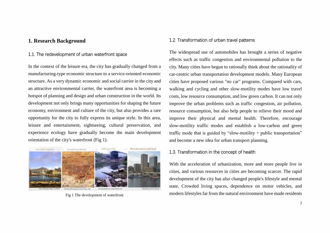
orientation of the city's waterfront (Fig 1).
Fig 1 The development of waterfront
1.2. Transformation of urban travel patterns
The widespread use of automobiles has brought a series of negative
effects such as traffic congestion and environmental pollution to the
city. Many cities have begun to rationally think about the rationality of
car-centric urban transportation development models. Many European
cities have proposed various "no car" programs. Compared with cars,
walking and cycling and other slow-motility modes have low travel
costs, low resource consumption, and low green carbon. It can not only
improve the urban problems such as traffic congestion, air pollution,
resource consumption, but also help people to relieve their mood and
improve their physical and mental health. Therefore, encourage
slow-motility traffic modes and establish a low-carbon and green
traffic mode that is guided by “slow-motility + public transportation”
and become a new idea for urban transport planning.
1.3. Transformation in the concept of health
With the acceleration of urbanization, more and more people live in
cities, and various resources in cities are becoming scarcer. The rapid
development of the city has also changed people's lifestyle and mental
state. Crowded living spaces, dependence on motor vehicles, and
modern lifestyles far from the natural environment have made residents
3
more and more health problems, and the health of the population is
threatened. The ultimate source of many health problems comes from
the influence of physical and social environment. The environment has
a more universal impact on health than human behavior. The
Transformation in the concept of health has led to a shift in the
resolution of health problems from a medical model to a social model.
In this context, waterfront areas with unique natural resources are an
important part of health promotion initiatives.
2. The analysis of related concepts
2.1. Concept Definition of Slow-motility traffic
There are many ways to express slow-motility traffic. Non-Motorized
transport (NMT) is a conventional term, including walking, cycling,
jogging and roller skating. NMT focuses on the classification of
vehicles and is therefore mostly used in transportation planning.
Pedestrians & cycling (P&C) is a combination of pedestrian traffic and
bicycle traffic. Compared to NMT, there are only two modes of
transportation. Human Powered Mobility is basically the same as NMT,
and it is a transportation method that uses manpower as a mobile force.
Soft Mobility, which includes bicycles, pedestrians, skateboards, roller
skating and other forms of transportation, first appeared in the report of
the Swiss Ministry of Environment, Transport, Energy and
Communications (DETEC). In addition to the meaning of
transportation, it also contains a green and sustainable meaning, and
also includes stops that occur during the tour. It is more suitable for the
environmental characteristics of the waterfront. Similar words include
Low-traffic, soft traffic, and so on1.
Slow-motility transportation usually refers to a transportation that is
powered by human power 2 . The main features of slow-motility
transportation include: average travel speed is low, generally not more
than 15km/h, walking speed is distributed in 0.5m/s - 2.16m/s, bicycle
speed is generally 10km/h. The distance traveled by slow-motility
transportation is also relatively short, generally less than 3km.
Slow-motility transportation is free, flexible and pollution-free, and it
also has the effect of exercising. It is a green way of travel.
1 Rosa Anna La Rocca, Soft Mobility and Urban Transformation, Journal of Land Use,
Mobility and Environment 2, 2010.04
2 Shanghai Municipal Government. Shanghai Metropolitan Transport White Paper [M].
Shanghai: Shanghai People's Publishing House, 2002
4
2.2. Concept Definition of Urban Waterfront slow-motility Space
The waterfront slow-motility space is different from the general urban
road that simply provides transportation functions. It has a combination
of leisure, fitness, and sightseeing functions. The urban waterfront
slow-motility space proposed in this paper refers to: A public space for
users to perform slow activities, which is in the spatial scope of urban
waterfront, distributed along the urban water system, connecting
various waterfront green spaces, parks and plazas and with relatively
complete supporting service facilities.
3. Research content
3.1. Research content
The content of this study includes three parts: landscape perception
analysis, design experience and design method summary and landscape
evaluation system, including the following points:
1) Combine the relevant theoretical and practical results of waterfront
landscape and slow-motility space, and explore the relationship
between urban waterfront landscape and leisure slow-motility system,
and summarize the landscape design factors and influencing factors of
waterfront slow-motility space.
2) Analyze the landscape characteristics of the waterfront area and the
interaction between the landscape and human behavior and psychology;
study the activity characteristics and demand levels of the
slow-motility people; around the sensory perception, spatial perception,
risk perceive and conduct research on emotional perception and other
aspects, and comprehensively understand and grasp the landscape
perception of the waterfront slow-motility space.
3) Collect and organize excellent waterfront development cases, such
as the construction of the Chicago Riverwalk Expansion, the landscape
reconstruction along the Thames River in London, the construction of
the bicycle lane around Taiwan, and the design of the Shanghai World
Expo Riverside Greenland and Suzhou Creek, analyzing the reasons
for its success and the perception of landscape designed for reference.
4) Propose the landscape design method of urban waterfront
slow-motility space from three aspects: Organization of the functional
structure, organization of the path and view and Organization of the
space sequence.
5
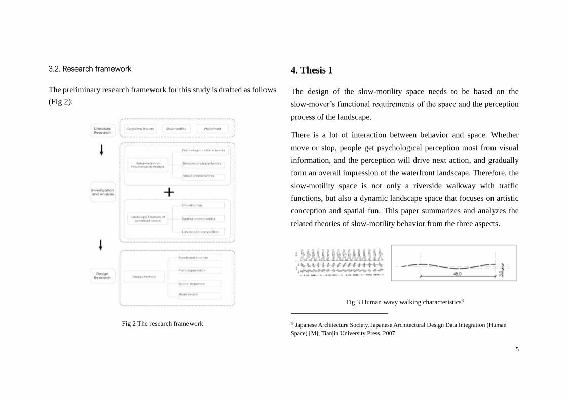
3.2. Research framework
The preliminary research framework for this study is drafted as follows
(Fig 2):
Fig 2 The research framework
4. Thesis 1
The design of the slow-motility space needs to be based on the
slow-mover’s functional requirements of the space and the perception
process of the landscape.
There is a lot of interaction between behavior and space. Whether
move or stop, people get psychological perception most from visual
information, and the perception will drive next action, and gradually
form an overall impression of the waterfront landscape. Therefore, the
slow-motility space is not only a riverside walkway with traffic
functions, but also a dynamic landscape space that focuses on artistic
conception and spatial fun. This paper summarizes and analyzes the
related theories of slow-motility behavior from the three aspects.
Fig 3 Human wavy walking characteristics3
3 Japanese Architecture Society, Japanese Architectural Design Data Integration (Human
Space) [M], Tianjin University Press, 2007
6
The psychological perception part is based on Jan Gehl’s theory. The
behavioral characteristics part includes walking, stop and stay and
riding behavior. When a person walks in nature, the traveling route is
not a strict straight line, but with a tendency to fluctuate with a certain
curvature (Fig 3). Therefore, the path with a certain curvature is better
for walking. The visual characteristics part includes five parts, namely
visual field analysis, viewpoint analysis, line of sight analysis, vision
analysis, visual perception.
5. Thesis 2
The waterfront space has many different types according to scales,
surrounding environment function, and the relationship between water
and city. As a place for recreational activities and open space, the
waterfront has common spatial characteristics, namely reachability,
continuity and possibility of staying. These three attributes are also the
landscape design principles and goals of slow-motility space.
6. Thesis 3
The slow-motility space is the link between the open space and the
activity place in the waterfront area. Therefore, the organization of
functional structure is one of the key points of landscape design. The
specific structural forms of waterfront slow-motility space include
axis-band-point, axis-band, axis-point, axis-zone mode. Each mode is
suitable for waterfront with different width.
○1 Axis: including the real axis and the virtual axis, the real axis refers
to the traffic axis, including the walking and bicycle lanes inside the
waterfront area, and the virtual axis refers to the channel itself and the
structural axis or the sight corridor.
○2 Spot: the gathering point of the crowd, and it is also the point of
interest and visual attraction in the slow-motility process, including the
riverside landscape nodes and activities, highlights and so on.
○3 Belt: refers to the leisure green space dominated by plant landscape,
filling the middle area between the axis and the axis or the axis and the
spot. It is mainly composed of plants and small landscape nodes, which
is a viewing experience belt.
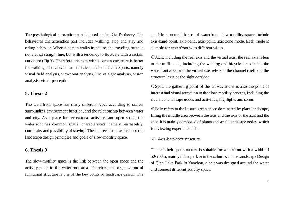
6.1. Axis-belt-spot structure
The axis-belt-spot structure is suitable for waterfront with a width of
50-200m, mainly in the park or in the suburbs. In the Landscape Design
of Qian Lake Park in Yanzhou, a belt was designed around the water
and connect different activity space.
7
Fig 5 Axis - belt – spot mode functional structure
Fig 6 Landscape Design of Qian Lake Park
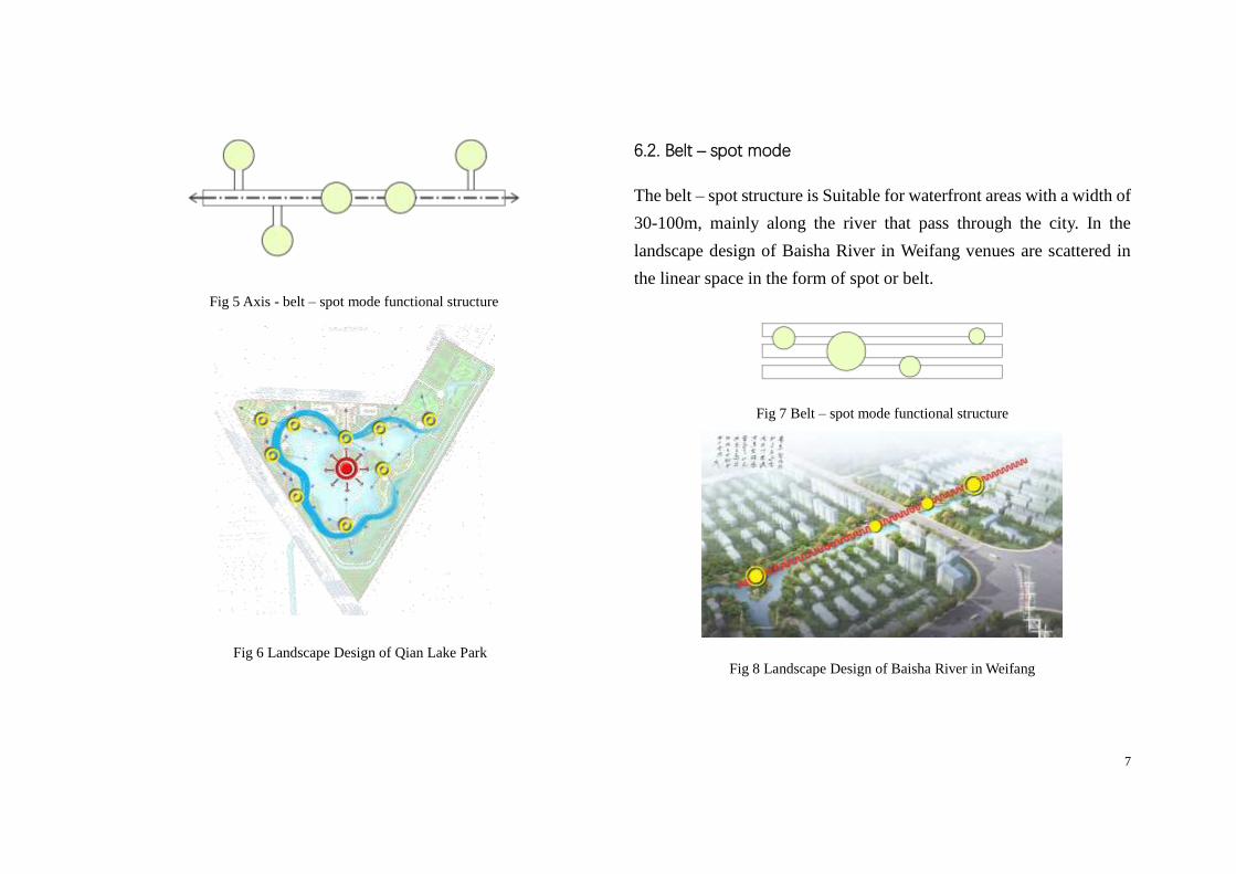
6.2. Belt – spot mode
The belt – spot structure is Suitable for waterfront areas with a width of
30-100m, mainly along the river that pass through the city. In the
landscape design of Baisha River in Weifang venues are scattered in
the linear space in the form of spot or belt.
Fig 7 Belt – spot mode functional structure
Fig 8 Landscape Design of Baisha River in Weifang
8
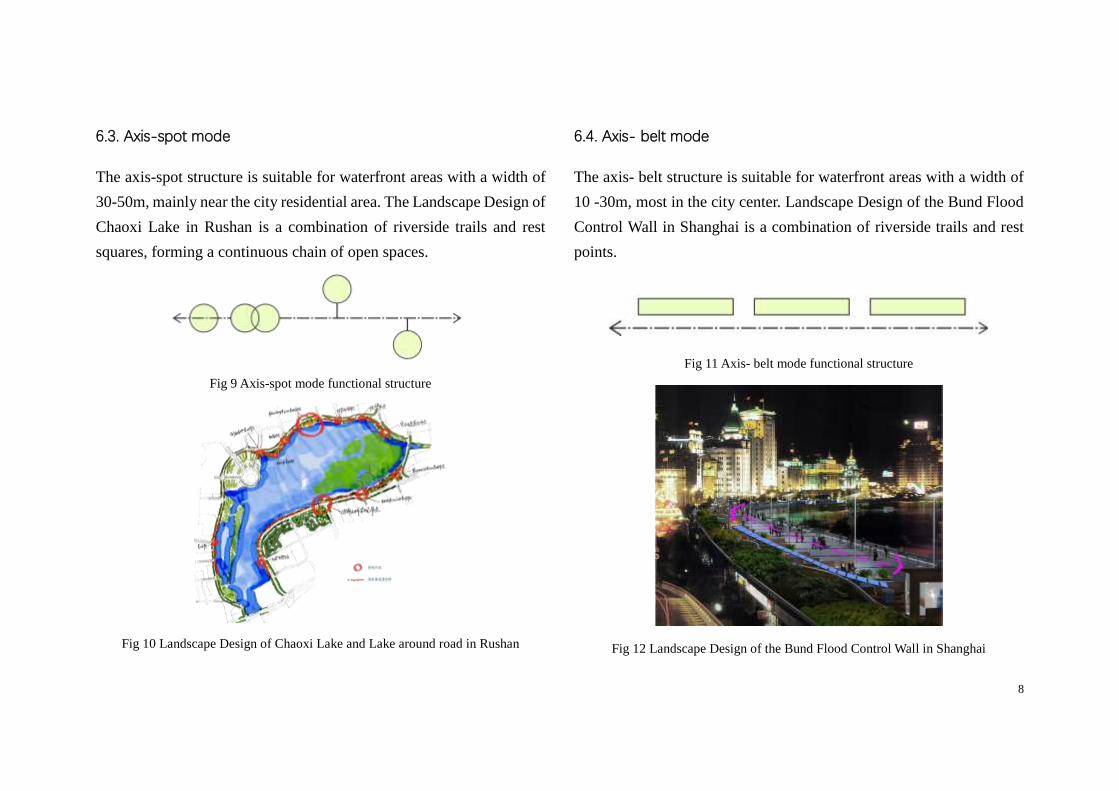
6.3. Axis-spot mode
The axis-spot structure is suitable for waterfront areas with a width of
30-50m, mainly near the city residential area. The Landscape Design of
Chaoxi Lake in Rushan is a combination of riverside trails and rest
squares, forming a continuous chain of open spaces.
Fig 9 Axis-spot mode functional structure
Fig 10 Landscape Design of Chaoxi Lake and Lake around road in Rushan
6.4. Axis- belt mode
The axis- belt structure is suitable for waterfront areas with a width of
10 -30m, most in the city center. Landscape Design of the Bund Flood
Control Wall in Shanghai is a combination of riverside trails and rest
points.
Fig 11 Axis- belt mode functional structure
Fig 12 Landscape Design of the Bund Flood Control Wall in Shanghai
9
It is necessary to take the function as the leading factor,
comprehensively measure the width of the riverside green space, the
service population, the nature of the surrounding land, etc., and select
the appropriate structural form to organize the order of the
slow-motility space.
7. Thesis 4
The continuous space experience formed by this order guides people's
movement direction, stimulates people's emotions, and finally forms
the rambler's overall feeling of the waterfront space. The waterfront
space usually is linear, and can subdivided into three organizational
modes. Each mode can form a space sequence with rhythm changes.
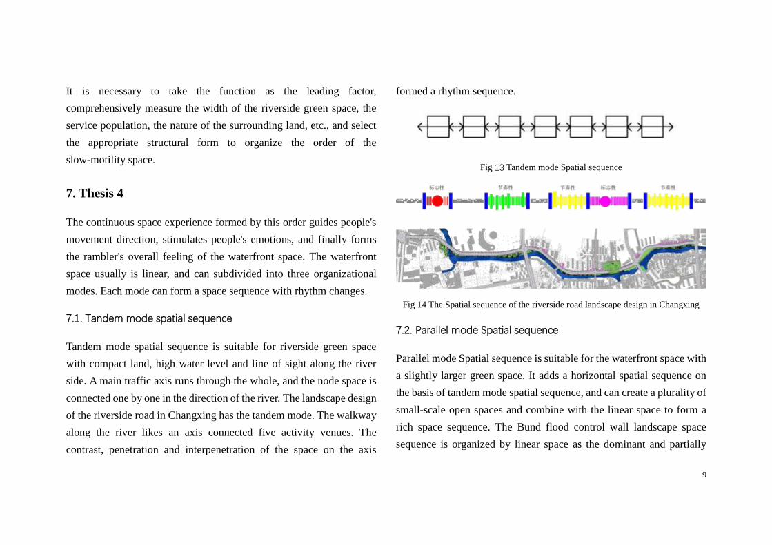
7.1. Tandem mode spatial sequence
Tandem mode spatial sequence is suitable for riverside green space
with compact land, high water level and line of sight along the river
side. A main traffic axis runs through the whole, and the node space is
connected one by one in the direction of the river. The landscape design
of the riverside road in Changxing has the tandem mode. The walkway
along the river likes an axis connected five activity venues. The
contrast, penetration and interpenetration of the space on the axis
formed a rhythm sequence.
Fig 13 Tandem mode Spatial sequence
Fig 14 The Spatial sequence of the riverside road landscape design in Changxing
7.2. Parallel mode Spatial sequence
Parallel mode Spatial sequence is suitable for the waterfront space with
a slightly larger green space. It adds a horizontal spatial sequence on
the basis of tandem mode spatial sequence, and can create a plurality of
small-scale open spaces and combine with the linear space to form a
rich space sequence. The Bund flood control wall landscape space
sequence is organized by linear space as the dominant and partially
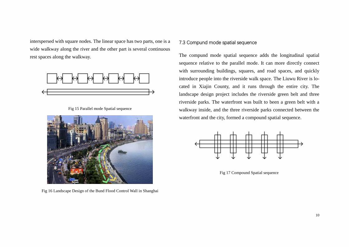
10
interspersed with square nodes. The linear space has two parts, one is a
wide walkway along the river and the other part is several continuous
rest spaces along the walkway.
Fig 15 Parallel mode Spatial sequence
Fig 16 Landscape Design of the Bund Flood Control Wall in Shanghai
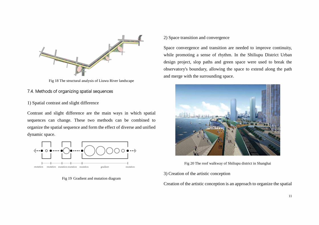
7.3 Compund mode spatial sequence
The compund mode spatial sequence adds the longitudinal spatial
sequence relative to the parallel mode. It can more directly connect
with surrounding buildings, squares, and road spaces, and quickly
introduce people into the riverside walk space. The Liuwu River is lo-
cated in Xiajin County, and it runs through the entire city. The
landscape design project includes the riverside green belt and three
riverside parks. The waterfront was built to been a green belt with a
walkway inside, and the three riverside parks connected between the
waterfront and the city, formed a compound spatial sequence.
Fig 17 Compound Spatial sequence
11
Fig 18 The structural analysis of Liuwu River landscape
7.4. Methods of organizing spatial sequences
1) Spatial contrast and slight difference
Contrast and slight difference are the main ways in which spatial
sequences can change. These two methods can be combined to
organize the spatial sequence and form the effect of diverse and unified
dynamic space.
Fig 19 Gradient and mutation diagram
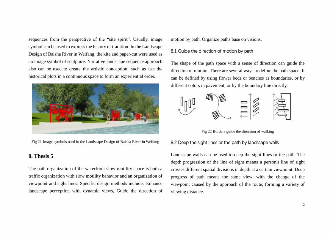
2) Space transition and convergence
Space convergence and transition are needed to improve continuity,
while promoting a sense of rhythm. In the Shiliupu District Urban
design project, slop paths and green space were used to break the
observatory's boundary, allowing the space to extend along the path
and merge with the surrounding space.
Fig 20 The roof walkway of Shiliupu district in Shanghai
3) Creation of the artistic conception
Creation of the artistic conception is an approach to organize the spatial
12
sequences from the perspective of the “site spirit”. Usually, image
symbol can be used to express the history or tradition. In the Landscape
Design of Baisha River in Weifang, the kite and paper-cut were used as
an image symbol of sculpture. Narrative landscape sequence approach
also can be used to create the artistic conception, such as use the
historical plots in a continuous space to form an experiential order.
Fig 21 Image symbols used in the Landscape Design of Baisha River in Weifang
8. Thesis 5
The path organization of the waterfront slow-motility space is both a
traffic organization with slow motility behavior and an organization of
viewpoint and sight lines. Specific design methods include: Enhance
landscape perception with dynamic views, Guide the direction of
motion by path, Organize paths base on visions.
8.1 Guide the direction of motion by path
The shape of the path space with a sense of direction can guide the
direction of motion. There are several ways to define the path space. It
can be defined by using flower beds or benches as boundaries, or by
different colors in pavement, or by the boundary line directly.
Fig 22 Borders guide the direction of walking
8.2 Deep the sight lines or the path by landscape walls
Landscape walls can be used to deep the sight lines or the path. The
depth progression of the line of sight means a person's line of sight
crosses different spatial divisions in depth at a certain viewpoint. Deep
progress of path means the same view, with the change of the
viewpoint caused by the approach of the route, forming a variety of
viewing distance.
13
Fig 23 The landscape wall in Qian Lake Park in Yanzhou
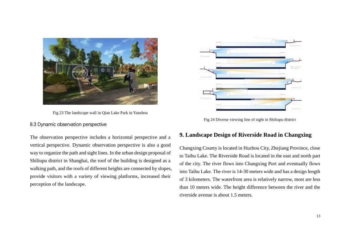
8.3 Dynamic observation perspective
The observation perspective includes a horizontal perspective and a
vertical perspective. Dynamic observation perspective is also a good
way to organize the path and sight lines. In the urban design proposal of
Shiliupu district in Shanghai, the roof of the building is designed as a
walking path, and the roofs of different heights are connected by slopes,
provide visitors with a variety of viewing platforms, increased their
perception of the landscape.
Fig 24 Diverse viewing line of sight in Shiliupu district
9. Landscape Design of Riverside Road in Changxing
Changxing County is located in Huzhou City, Zhejiang Province, close
to Taihu Lake. The Riverside Road is located in the east and north part
of the city. The river flows into Changxing Port and eventually flows
into Taihu Lake. The river is 14-30 meters wide and has a design length
of 3 kilometers. The waterfront area is relatively narrow, most are less
than 10 meters wide. The height difference between the river and the
riverside avenue is about 1.5 meters.
14
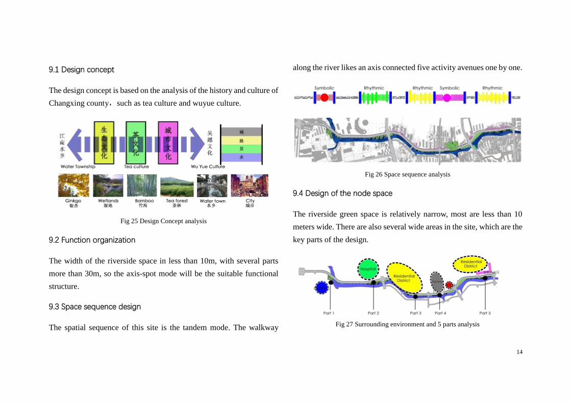
9.1 Design concept
The design concept is based on the analysis of the history and culture of
Changxing county,such as tea culture and wuyue culture.
Fig 25 Design Concept analysis
9.2 Function organization
The width of the riverside space in less than 10m, with several parts
more than 30m, so the axis-spot mode will be the suitable functional
structure.
9.3 Space sequence design
The spatial sequence of this site is the tandem mode. The walkway
along the river likes an axis connected five activity avenues one by one.
Fig 26 Space sequence analysis
9.4 Design of the node space
The riverside green space is relatively narrow, most are less than 10
meters wide. There are also several wide areas in the site, which are the
key parts of the design.
Fig 27 Surrounding environment and 5 parts analysis
15
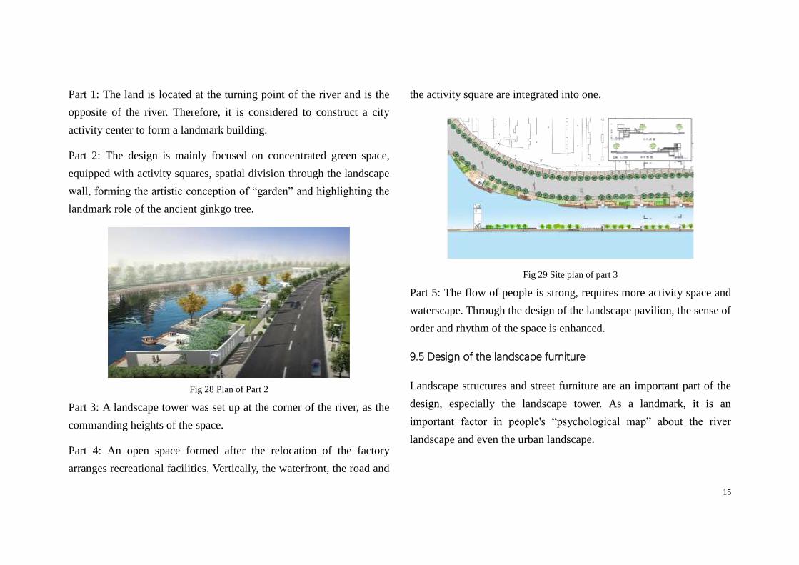
Part 1: The land is located at the turning point of the river and is the
opposite of the river. Therefore, it is considered to construct a city
activity center to form a landmark building.
Part 2: The design is mainly focused on concentrated green space,
equipped with activity squares, spatial division through the landscape
wall, forming the artistic conception of “garden” and highlighting the
landmark role of the ancient ginkgo tree.
Fig 28 Plan of Part 2
Part 3: A landscape tower was set up at the corner of the river, as the
commanding heights of the space.
Part 4: An open space formed after the relocation of the factory
arranges recreational facilities. Vertically, the waterfront, the road and
the activity square are integrated into one.
Fig 29 Site plan of part 3
Part 5: The flow of people is strong, requires more activity space and
waterscape. Through the design of the landscape pavilion, the sense of
order and rhythm of the space is enhanced.
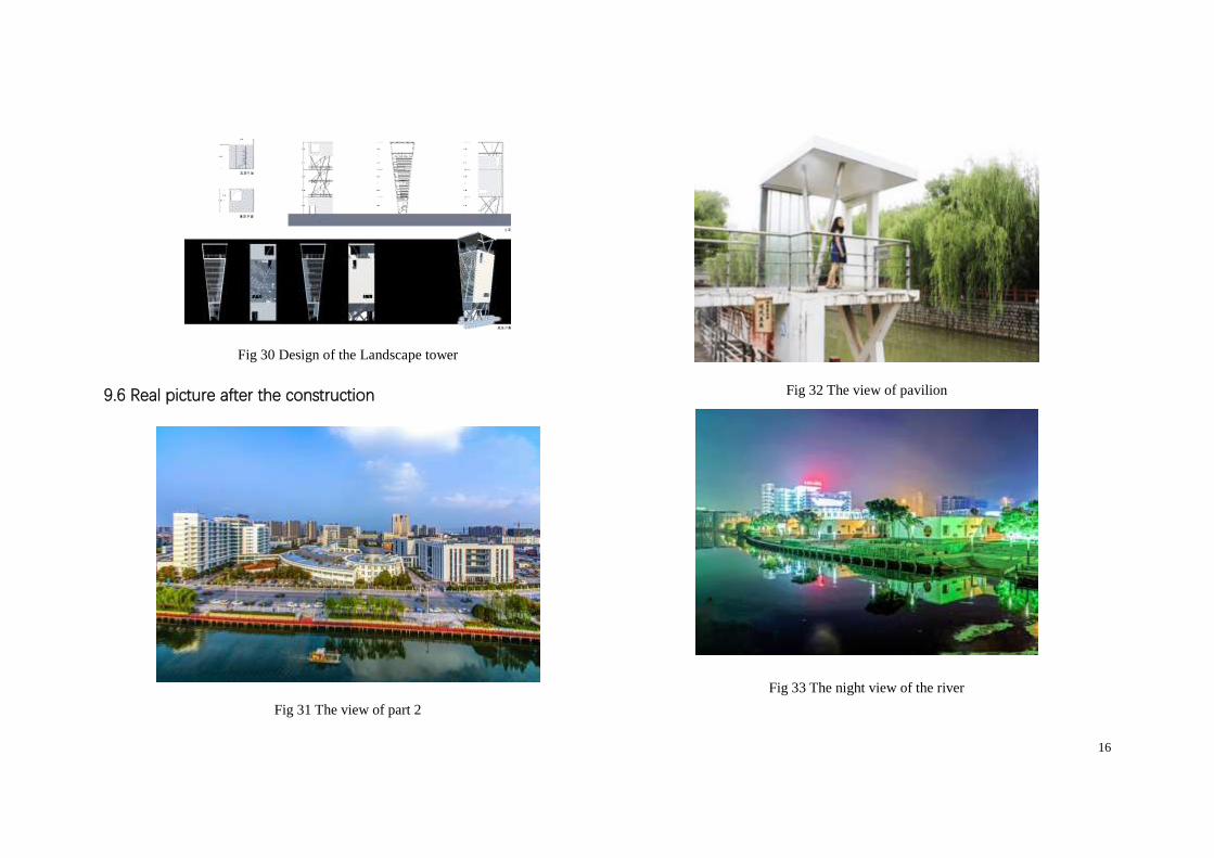
9.5 Design of the landscape furniture
Landscape structures and street furniture are an important part of the
design, especially the landscape tower. As a landmark, it is an
important factor in people's “psychological map” about the river
landscape and even the urban landscape.
16
Fig 30 Design of the Landscape tower
9.6 Real picture after the construction
Fig 31 The view of part 2
Fig 32 The view of pavilion
Fig 33 The night view of the river
17
Reference
1. Rosa Anna La Rocca, Soft Mobility and Urban Transformation, Journal of Land
Use, Mobility and Environment 2, 2010.04
2. Shanghai Municipal Government. Shanghai Metropolitan Transport White
Paper [M]. Shanghai: Shanghai People's Publishing House, 2002
3. Japanese Architecture Society, Japanese Architectural Design Data Integration
(Human Space) [M], Tianjin University Press, 2007
4. Rudolf Arnhim; Teng Shouyi translation. Visual thinking: aesthetic intuition
psychology [M]. Sichuan People's Publishing House .1998
5. John Ormsbee Simonds. Landscape design - site planning and design manual
[M] China Building Industry Press. 2000
6. Simon Bel. Landscape Visual design elements [M]. China Architecture &
Building Press,2004
7. Shen Kening. Space perception Time and memory in [J]. Architect, 2015,
04:48-55.
8. Yang Fan, Jin Ling, Sun Zhili. Organization of Landscape Sequences [J].
Central South Forestry Investigation and Planning, 2000, 04:39-43
9. Awara Yoshishinori; Yin Peitong translation. External space design [M] China
Building Industry Press. 1985
10. Yu Kongjian. 2010 Shanghai World Expo Park - Houtan Park. Beijing: China
Building Industry Press, 2010
11. Rudolf Arnheim. Art and visual perception [M]. Sichuan People's Publishing
House, 1998
12. Dou Degu. Basic Analysis of Line of Sight and Route in Architectural Space
Experience [J]. Taizhou Vocational and Technical Journal, 2004. 03:18-21
Publications
1. Concepts For Waterfront Developments, Focusing On Siofok, Hungary
Pollack Periodica Vol. 13, No. 1, 2018 ISSN 1788-1994
2. Design Concepts and Methods of the Zero-emission Building RATI in
Hungary
Industrial Construction No.10,2018 ISSN:1000-8993
3. The Research on Application and Development of Interactive
Architecture-senses and Responses
Architecture and Culture, No. 5/6, 2018 ISSN:1672-4909
4. Thinking of the Landscape Design Course
ART AND DESIGN, No. 7, 2009 ISSN: 1008-2832
5. Reflections on the Teaching of Environmental Design
Inside and Outside_4&4 Workshop Proceedings
China architecture & building press. 2018 ISBN:9787112215225
6. Application of the Constructivism Learning Theory in Urban Design
Course Social needs urban sustainability _ Proceedings of China urban
planning education conference 2009, China architecture & building press.
ISBN: 9787112103508