Embed Size (px)
Citation preview

Fourth LACCEI International Latin American and Caribbean Conference for Engineering and Technology (LACCET’2006) “Breaking Frontiers and Barriers in Engineering: Education, Research and Practice” 21- 23 June 2006, Mayaguez, Puerto Rico.
Landslides in Trinidad – A Geotechnical Study
Vasudevu Kanithi, Ph. D. Lecturer, Department of Civil and Environmental Engineering, University of the West Indies, St.
Augustine, Trinidad and Tobago, E-mails: [email protected], [email protected]
Chattergoon Kanhai Chief Engineering Technician, Department of Civil and Environmental Engineering, University of the West Indies,
St. Augustine, Trinidad and Tobago, E-mail: [email protected] Abstract The present paper is the geotechnical study of landslides, carried out as a consequence of the news paper reports with photographs during a tropical depression on 15th and 16th of November 2005. Torrential showers caused extensive floods and landslides accounting for some deaths and damage to houses, agricultural land properties, roadways and bridges. Large amount of debris and mud was dumped into the streams contributing to flooding of some rivers. This is a common phenomenon every year during heavy rains in this part. The sites where landslides have been reported recently and also some other places where landslides took place in the earlier years were visited and the geotechnical observations were made. Keywords landslide, mudslide, rainfall, slope failure, disaster Introduction News paper captions like “Villages flooded, hundreds marooned” “Villages under water” and “Blanchisseuse house falling into the sea” (Guardian, 2005) attract the inquisitive mind. In Trinidad, especially in the areas where the investigations were carried out, massive crystalline rocks are not found. The slides occurred either mostly in the talus and highly foliated, jointed and fractured rocks; or in the loose soils. The slides that were observed are minor in nature. There are not big mass movements, though some times they affected the structures and caused flooding. The areas were toured and studied to understand their nature. Geological environment of the country with the type of rocks and soils is such that landslides are a common feature in the rainy season due to heavy rains. However, only those landslides which affect human habitat, roadways and agricultural lands are attracting public attention. Geology and Geomorphology To understand the nature of slides and the reasons, the geology and geomorphology (Suter, 1960, and Persad, K.M.1979) of the country is reviewed briefly. The Caribbean Island of Trinidad forms north-easternmost extension of the South American Continent. Physiographically, it is a part of the eastern Venezuela. Its approximate geographic point is 100 30’N and 610 15’W. It comprises a land area of 4827

sq. km. The climate is tropical and seasonal. The average temperature is 250C and the annual variation ranges from 21 to 300C. The rainfall averages 1520 mm. Topographically, the island is divided by three mountain ranges separated by undulating land, plains and swamps. The Northern Range fringes the Caribbean Sea. The Central Range bisects the island obliquely and the Southern Range forms the southern rim of the Island. Thus the country can be divided into five geomorphic regions and they are: 1. the Northern Range, 2. the Northern Basin, 3. the Central Range, 4. the Southern Basin and 5. the Southern Range. The Geological map of Trinidad is shown below:
Fig. 1: The geological map of Trinidad
The geology of the island is complex in relation to its size. However, it can briefly be reviewed considering the Northern Range consisting of the crystalline rocks (igneous and metamorphic) as a unit; and the Central and Southern Trinidad characterized by sedimentaries as another. The Northern Range The Northern range covers that part of the island which lies north of a line drawn from Port of Spain on the west to Matura Point on the east coast. It is a hilly rugged country almost inaccessible in some parts. It is asymmetric in profile, the northern slope being steeper. The southern side is marked by a belt of foot hills. The extreme southern foot is characterized by Pleistocene alluvial gravel fans and terraces. Laterally it can be divided into two parts by the Platanal - Cambural depression east of Cerro Aripo. The Range is built up of weakly metamorphosed soft and hard rocks. The lithology of this area is characterized by an inter-bedded sequence of weak rocks which are jointed and fractured. The rock types are limestone, marbles and phyllites. The age of the rocks is Mesozoic. The Central and Southern Trinidad The Northern Basin and the Central Range together form Central Trinidad. It extends from the foot hills of the Northern Range to those of the Central range. It consists of (i) flood plains and alluvial flats (vegas) of Caroni and the Northern Oropouche River systems (ii) northern terraces and (iii) Las Lomas peneplain. The Central Range consists of an irregular ridge running diagonally south-west to north-east across the island from Pointe-a-Pierre to Manzanilla Point. The western and middle section of this ridge is called the Montserrat Hills. The Central Range is about 35 miles long and between five and nine miles wide. It mainly consists of rounded hill-ridges radiated from rugged limestone peaks rising 918 feet in the Montserrat District., 884 feet at the Mont Harris and 1009 feet at Mont Tamana situated at the eastern end

of the Range. The ridges are separated by rivers containing fast moving streams fed by springs. The lithology of the area is of Tertiary limestones, sandstones and other sedimentary rocks and sediments. The Southern Basin, also named as the Naparima Peneplain differs from the Northern Basin mainly in its rather variable altitude which ranges from sea level to 250 feet at Dunmore Hill and 800 feet at San Fernando Hill. The Southern range is a row of hills arranged en echelon in NE-SW direction. It is separated into western and eastern parts by the Moruge Bouffe depression. Geologically it is a fold system open to the east. Locally, mud volcanoes have created marked hollows such as Moruga, Bouffe and Lagon Bouffe. In this range Tertiary sands, clays and marls alternate. The drainage The drainage system is carved by the ranges. The Caroni River drains the Northern range to the west. The Oropouche (north) drains the Cenral Range to the east, the Guaracara, the Navet and the Poole Rivers drain the Central Range to the southwest and southeast respectively. The Oropouche (south) River and the Ortoir River drain the Southern Range and Naparima area to the west and east respectively; and the Moruga River drains the Southern Range to the south. The geology of the Northern Range and the other parts of the country broadly differ in the sense that the Northern Range consists of crystalline (metamorphic) rocks and the remaining country consists of sedimentary rocks and loose sediments. Depending on the geology, the type of slides also differed. So the study also made with this perspective. The locations of the slides observed in the Northern Range and those observed in the south are shown below.
Fig. 2: Landslide locations in the Northern Range and in the south

Fig. 3: Cut vertical face of the forest comprising alternate layers of shales, limestones and phyllites The rocks consist of micaceous phyllite alternating with limestone, shale and marls. The rock mass is fragmented by different sets of joints and fractures. The strike direction is N-S. The rocks dip 450 due S 300 E. Although it is vertical the slope is stable because of its geology.
Fig. 4: Slump: The material has come down vertically with some of the trees standing straight. One of the slides where the rock mass has vertically come down. The slide has taken place in the talus.
Some of the trees are vertical. Here the slope can be stabilized by a simple retaining wall or gabions.
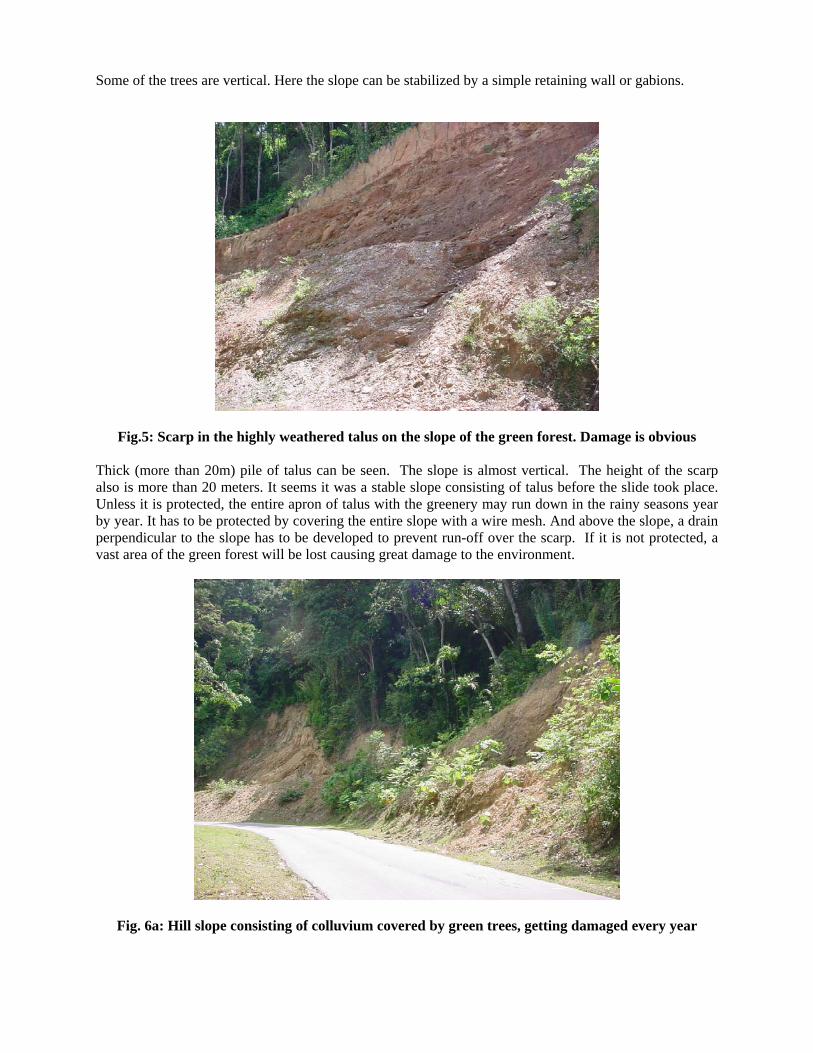
Fig.5: Scarp in the highly weathered talus on the slope of the green forest. Damage is obvious
Thick (more than 20m) pile of talus can be seen. The slope is almost vertical. The height of the scarp also is more than 20 meters. It seems it was a stable slope consisting of talus before the slide took place. Unless it is protected, the entire apron of talus with the greenery may run down in the rainy seasons year by year. It has to be protected by covering the entire slope with a wire mesh. And above the slope, a drain perpendicular to the slope has to be developed to prevent run-off over the scarp. If it is not protected, a vast area of the green forest will be lost causing great damage to the environment.
Fig. 6a: Hill slope consisting of colluvium covered by green trees, getting damaged every year

Here are two slides with a valley between them. The slide is in the talus consisting of debris of phyllites and other loose materials. They are highly weathered. The slide could have been avoided, had precautionary measures been taken. Besides, wide cracks developed on the other side of the road. The situation here has been shown in the following model.
S lide S carp
R ew ta ining W all
C racks
O rigina l S lope
D ra in fo r R un-o ffon the S lope
R O A D
Fig. 6b: A schematic presentation of the present situation and the protective measures to be taken
On one sine of the road there are slides in the slope. On the other side also two wide cracks have developed and slides may take place in the next rainy seasons. The steps to be taken here for stability are:
1. A drain has to be developed between the two slides. 2. Another drain has to be built between the road and the slope to prevent run off over the road. This
would help prevent slumping and erosion on the other side of the road. 3. The slope face has to be protected by retaining wall supported by buttresses and 4. The slope between the retaining walls has to be terraced.
Fig. 7: Rock-waste along the slope over a vast area. The trees on the left top corner look hanging when the soil cover eroded
Also, the slope on the other side of the road has developed cracks. The height of the scarp is about 30 meters. For purpose of study and analysis the area can be viewed as five independent units (fig. 7a). They are: 1. the extreme left slope, 2. the water course, 3. the slope, 4.
another water course and 5. the slope. Slope stabilization has to be taken up considering each one of these as a single unit. 1. The extreme left slope: Water running down the hill slope has totally removed the talus over the
slope exposing the bed rock. The soil under the roots of the trees is removed. (The gap between the outcrop and the tree trunk is seen). Here, a retaining wall may be useful for slope stabilization.
2. The water course: there are valleys above the slope. Water collected in the valleys flows down the channel. The run-off has eroded the talus on both sides. This water course has to be developed with a paved channel for free flow of water with protection on both sides.
3. The vertical elevation of this slope is more than 30 meters. This slope has to be terraced with sufficient number of retaining structures along the slope.
4. Another water course: this also has to be developed. And Above this water course, a paved channel perpendicular to this water course minimizes water flow in this drain and reduces erosion.
5. This slope has to be stabilized just as in the case of the previous slope by retaining walls and terraces between them.
6. A small drain existed between the road and the hill slope but it was damaged. Another drain, all along the length, has to be built to avoid run-off flow over the road and the slope below.
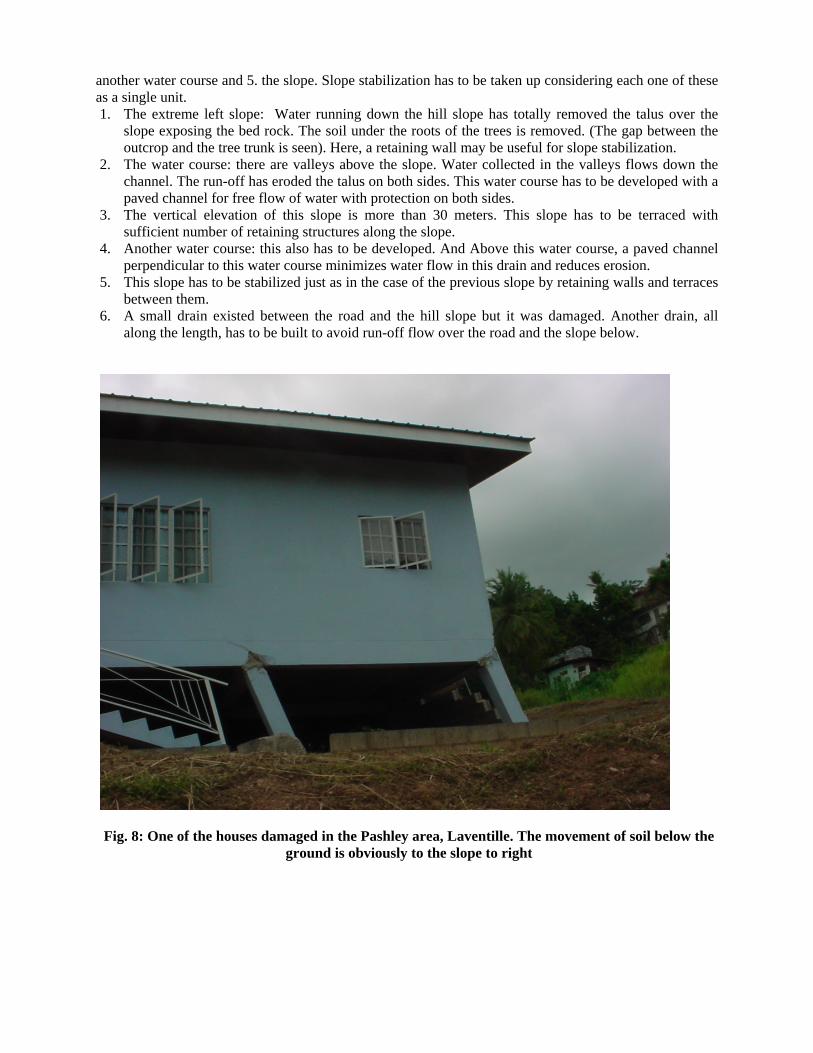
Fig. 8: One of the houses damaged in the Pashley area, Laventille. The movement of soil below the ground is obviously to the slope to right

Fig. 9: another house damaged in the Pashley area, Laventille
Fig. 10: The mudslide over the top of the slope. Looks like viscous lava flow. An old slide on the left

Discussion Depending on the geological conditions, landslides /mudslides in the country are made into two groups – 1) slides that occur in areas of crystalline rocks are put in one group - these are observed along the road passing through the Northern Range; and 2) those that take place in the sedimentary rocks, and unconsolidated sediments/soils constitute another group – these are observed in natural slopes in the Central and Southern Trinidad.
All the slides recorded in the Northern Range are along the all-weather Maracas Road, which is very important for traffic. All through, the road passes along the slope of the forest. The hill slope was cut to form the road. At some places the cut face of the mountain is almost vertical, but the rocks are dipping in the directions away from the cut face (fig.3). In such places the slope is very stable. It was observed that slides took place only where there is a thick layer of talus over the bed rock of the slope. The bed rock of micaceous schists, limestones and marls is covered by an apron of weathered talus and the slides are taking place only in the apron. According to the definition (Duff, P. Mc L. D. 1998), these are debris slides, soil slips or slumps, because the material was simply dislodged and fell at the foot of the hill slope. There was no translational or rotational movement and the material moved along its own slip plane within a body of unconsolidated material unlike a slide which moves downward along a plane of weakness. Soil slips require a combination of three conditions: (1) A mantle of colluvial soil or a wedge of colluvial ravine fill, on (2) a steep slope where (3) soil moisture is equal to or greater than the liquid limit of the remolded colluvial soil (Campbell, H. R.1975) and these slides have taken place under these conditions. The road is on steep slopes and there is a possibility of the road being damaged in the future. At a few places, slope erosion on the downstream side of the road is observed. At these sites (figures 6& 7), cracks have developed in the ground on the other side of the road and they are likely to cause damage in future. If care is taken to see that water coming from the hill slope is diverted by a drain as shown in the fig.6b, erosion of the slope can be avoided to a great extent. Slides of the second category (figures 8, 9&10) took place in the soils and mud, sometimes of volcanic origin which are becoming viscous when saturated with water and flowing like viscous lava (Fig.10). The slopes in these areas are sometimes hardly 50. The approach of study as well as addressing the problems in these areas differs. Slides were observed in the Pashley area of Laventlle in Port of Spain and along the Naparima – Mayaro Road which involved destabilization of structures existing over the soils. Slides are prone to occur when high plasticity clays alternate with silty clays of medium to high plasticity with varying thickness and plasticity. According to Larsen and Grande (1999) slides might be interpreted with swelling of clay material until failure. The physical properties of materials also control slides. Clay minerals, especially, minerals of montmorillonite group are hydrophylic and swell in the presence of water. Nelson and Tepel (1999) observed that the clay fraction composed of smectite clay minerals in the soils from the landslide surface. Turbulence in the sloping ground by moving vehicles is may be responsible to trigger the slide. Incidentally, all the slides where the structures were damaged are the Pashley area which is crisscrossed by roads and also beside the Naparima - Mayaro Road and the vehicular movement over the road might cause shake to trigger the landslip in the oversaturated mud in the nearby area.
Conclusions The observed slides are of two types; they are the debris slides and mud flows. The debris slides are taking place in the apron of talus along the cut slopes of the Maracas Road and the mud flows are mostly in the soils of the central and southern parts of Trinidad. The slides are minor in nature in the sense that there is no big translational/rotational displacement and mass movement.

It is a matter of slope stability and the slides could have been avoided if engineering structures were taken up for prevention. If these places are not protected now, slides occur in every rainy season and it would be not only a perennial problem but a great damage to the beautiful environment. Simple engineering structures like retaining walls and terracing; and drains are to be taken up to contain downslope erosion and rock-waste. It was observed that the mudslides are the cause of damages and destruction to properties and flooding. A detailed mapping of the slides and study of the soils types, the grain size analysis and the mineralogy have to be carried out to have a better understanding of the mudslides in Trinidad. Remedial Measures Had preventive measures been taken before slides took place, if not all, most of them in the Northern Range could have been avoided. It may be because “the squeak of landslide wheels is drummed out by the din of other societal woes such as crime, traffic, education and health” (Howell and Brabb, 1999). Engineering structures like gabions, retaining walls supported by buttresses, terracing, development of drains perpendicular to slopes are to be taken up. It is more protective if each terrace is supported by a retaining structure. Where the scarp is vertical, it may be covered by wire mesh. To prevent run-off over the road and down the slope after the road and to protect from sliding and slope erosion, drainage has to be built between the hill slope and the road. To prevent flow of water coming from the forest slopes and valleys over the cut face, parallel paved channel has to be developed over the slopes. Creepers (not grass), bamboo plantations and shrubs are to be grown on the slopes. There must be a recognized agency as the principal authority for study of landslides and landslide hazard issues. References Campbell, H.R. (1975). “Soil Slip, Debris Flows and Rainstorms in the Santa Mountains and Vicinity, Southern California”. Geological Survey Professional Paper, U.S. Govt. Printing Office, Washington. Duff, P. Mc L. D. (1998). “Holmes Principles of Physical Geology” 4th edition. pp 294-295. Howell, D. G. and Brabb, E. E. (1999). “Interest in landslide hazard information – Parallels between
Kingston, Jamaica and the San Francisco Bay region, USA”. Landslides, Griffiths, Stokes and Thomas (editors), Balkema, Rottendam, ISBN 90 5808 078 7, pp 73-79.
Larsen, J. O and Grande, L. (1999). “Slide activity in quick clay related to pore water pressure and weather parameters” Landslides, Balkema, Rotterdam, ISBN 90 5809 078 7, pp 97-110
Nelson, J.L. and Tepel, R.E. (1999). “Tracking landslide creep and its response to El Nino and local seismicity: A case history from the Penitencia Creek landslide, Santa Clara Country, California, USA” Landslides, 1999 Balkema, Rotterdam, ISBN 90 5809 078 7, pp 81-88
Persad, K.M. (1979). “Outline of the Geology of the Trinidad Area”. Fourth Latin American Geological Congress Trinidad and Tobago, pp 738-758.
Suter, H. H. (1960), “The General and economic Geology of Trinidad”. B. W. I, 2nd edition. The Trinidad Guardian, Nevember16, 2005 and December8, 2005 Authorization and disclaimer The authors authorize LACCEI to publish the paper in the conference proceedings. Neither the LACCEI nor the editors are responsible for the content or for the implications of what is expressed in the paper.