Embed Size (px)
Citation preview
Page 1
Language: English
Original: French
AFRICAN DEVELOPMENT BANK GROUP
PROJECT : MULTINATIONAL TRANS-SAHARA HIGHWAY PROJECT
COUNTRIES : ALGERIA, NIGER AND CHAD
_____________________________________________________________________________
EXECUTIVE SUMMARY OF THE ENVIRONMENTAL AND SOCIAL IMPACT
ASSESSMENT
Project Team
Team
Leader
J. P. MEGNE EKOGA, Transport
Economist OITC.1
Team Members
J. N. ILBOUDO, Transport
Engineer OITC.1
J. P.M. KALALA, Principal
Socio-economist OITC.1
A. SIALA-FOURATI, Principal
Enviromental Officer ONEC.3
M. LABA, Disbursement Assistant TDFO
D. TILENGAR, Procurement
Officer
TDFO/O
RPF.1
S. MAOULOUD, Financial
Management Specialist
TDFO/O
RPF.2
S. OMAR ELMI, Young
Professional OITC.3
Sector Division
Manager Mr Jean Kizito KABANGUKA OITC1
Sector Director Mr Amadou OUMAROU OITC
Regional Director
Ms Marlène KANGA ORCE
Mr Janvier K. LITSE ORWA
Mr Jacob KOLSTER ORNB
Page 2
Summary of the Environmental and Social Impact Assessment
Project Name : MULTINATIONAL TRANS-SAHARA HIGHWAY PROJECT
Countries : ALGERIA, NIGER AND CHAD
Project Number : P-Z1-DB0-102
1. Introduction
This document summarizes the Environmental and Social Impact Assessment (ESIA) carried out
as part of the Multinational Trans-Sahara Highway (TSH) project covering three countries:
Algeria, Niger and Chad. Each impact assessment covers a separate component of the project.
These studies are:
Niger: two impact studies and a summarized resettlement plan are available:
- ESIA of the Arlit-Assamaka Road (Algerian Border), June 2013; study approved
by the Government of Niger;
- ESIA of the Farié Bridge on River Niger, March 2012; study approved by the
Government of Niger;
- Summarized resettlement plan, June 2012; and
- Chad: ESIA of the Massakory-Bol-Niger Border road, August 2011 (update of
the study conducted in 2005); study approved by the Government of Niger.
The road link running through Algeria will be financed in full by the country.
2. Project Description and Rationale
Project Objectives: The project’s sector objective is to contribute to the development of
commercial exchanges by road and to the regional integration between the Arab Maghreb Union
(AMU), ECOWAS and ECCAS, in general and Algeria, Niger and Chad, in particular. The
specific objectives are to: (i) improve the level of TSH service; (ii) reduce the time and cost of
transport and logistics on these links: Alger-Niamey, Alger-Ndjamena, Niamey-Ndjamena and
Niger-Burkina-Mali with the construction of the Farié Bridge; and (iii) improve the living
conditions of the residents of the project impact area. To achieve these objectives, the activities
to be carried out are grouped into six categories.
Description of the corridor: The Trans-Sahara Highway (TSH) is one of the major integration
projects promoted by NEPAD. It directly links six countries belonging to three of the eight
Regional Economic Communities (RECs) of the African Union, namely: Algeria and Tunisia
(AMU), Mali, Niger and Nigeria (ECOWAS) and Chad (ECCAS).
With the addition of the Farié Bridge, the project also provides easy access to Burkina Faso and
Mali. The direct project impact area comprises the 32 regions crossed, the 74 built-up areas
served, an area of 4.4 million km² and a population 60 million people (in addition to Burkina
Faso). The TSH has a total length of 9 022 linear kilometres, of which 7 771 km (80%) have
Page 3
already been asphalted, and 1 851 kilometres of dirt roads (20%). It comprises the 4 498 km-long
main road (which included 223 km of unpaved road in Niger), running from Algiers (Algeria) to
Lagos (Nigeria), via Zinder (Niger), and three secondary roads branching from this major road:
The Tunisian section, which runs from Ghardaia (Algeria) to Gabès (Tunisia).
This link is 866 km long and fully asphalted;
The Malian branch running from Bamako (Mali) to Tit (Algeria); it is 2 461 km
long and comprises 1 321 km of asphalted roads and 1 140 km of feeder roads;
and
The Chadian section, which links Ndjamena (Chad) and Zinder (Niger); it is 1 197
km long and comprises 724 km of asphalted roads and 473 km of feeder roads (of
which 415 km in Niger and 57 km in Chad currently being asphalted). It is worth
noting that in Chad, the construction of the 85 km-long Massakory-Ngouri section
will be entirely financed by the Islamic Development Bank (IDB). The
procurement procedure relating to these works is underway and the works should
soon begin.
The construction of the Arlit-Assamakka section in Niger and the section linking Ngouri-Bol-
Niger border to Chad is therefore of regional importance as it aims to fill in the missing links on
major axes of the TSH and its Chadian branch. Moreover, these roads are located on the trans-
African corridors running from Algiers to Lagos (ATT 2) and Dakar to Djibouti (ATT 5 and 6),
which were identified as priority links by the Programme for Infrastructure Development in
Africa (PIDA), of which AfDB is the executing agency and whose priority action plan was
endorsed by the African Heads of State Meeting of January 2012.
Alongside the construction of road infrastructure, it will be necessary to put in place measures
for facilitating trade and transit at the two borders, with a view to achieving the regional
integration objectives sought by the infrastructure investment. Consequently, the project is
highly inclusive since it would contribute to the opening up of Chad and Niger in the north and
the south, and the economic integration of the three regions (North, West and Centre).
Project Description: The project focuses essentially on the construction and asphalting of road
sections constituting the missing links of the main axis and the Chadian section of the TSH, of a
total length of 565 km, construction of a 543 metre-long bridge on River Niger at Farié, with 3
km of access roads, and the establishment of measures to ease transport and transit at the
Algeria-Niger and Niger-Chad border.
2.1. The Assamaka-Arlit Road Section in Niger
The Arlit-Assamaka-Algerian Border section is at the heart of the crucial economic, social and
political stakes for Nigeria, Niger and Algeria and, beyond these countries, for the region and the
continent. Its construction is faced with multiple constraints related to the security situation in
the area and nomadism of the local population. This situation is a hindrance to improved
commercial exchanges and enhanced integration. However, the growth and diversification of
these exchanges require constant support from the States individually and collectively in their
bilateral and multilateral relations.
Page 4
At national level, the construction of this road infrastructure derives its legitimacy from the
economic stimulus programme that is manifest in the preparation of three (3) main strategic
documents: the “Sustainable Development and Inclusive Growth Strategy” (SDDCI NIGER
2035), the Socio-Economic Development Plan (SEDP 2012-2015) and Interim Framework
Programme of Government Action (IGAC 2011-2012).
The work to be carried out concerns mainly the construction and asphalting of the Arlit-
Assamaka-Algerian Border 225 km-long road, including the 2-km connecting road leading to
Arlit city centre. The roadway is 7.0 m wide, with a 2 x 1.50 m shoulder, or a 10-metre roadbed.
The total right-of-way is 12 metres wide on each side of the centreline of the road, which adds up
to a total surface area of 5 400 000 m2.
2.2. Farié Bridge on River Niger
As part of implementation of its transport sector policy, the Government of Niger has decided to
prioritize the rehabilitation and improvement of existing infrastructure, and the building of new
communication lines. Part of the traffic between the WAEMU countries (especially eastern Mali,
northern Burkina Faso and western Niger) makes use of the Ouagadougou-Kaya-Dori-Téra-
Niamey-Farié road, which is part of the WAEMU countries Community Action Programme for
Infrastructure and Road Transport (PACITR).
Currently, the Ouagadougou-Kaya-Dori-Téra-Niamey-Farié road is fully asphalted and the Bank
has contributed to the financing of this link, particularly the Dori-Téra section. A significant
increase in traffic is expected, with a large portion of the flow of the heavy duty traffic heading
towards eastern Mali and western Niger, as well as towards the Niger River valley from Atlantic
Ocean ports (Lomé, Accra, Tema and Abidjan). The major obstacle is the River Niger on which
there is no bridge. At Farié, the two banks of River Niger are now connected by a ferry with a
capacity that does not exceed 12 passenger car units (pcu) and operating only 12 hours a day,
from 6.30 a.m. to 8.30 p.m., with a two-hour break from 12 noon to 2.40 p.m. This results in
wasted time and increased transport overheads. To enable users to save time and ease the flow of
the expected heavy traffic, WAEMU has funded detailed technical studies on the economic
feasibility and environmental and social impact of a bridge on River Niger at Farié, with a view
to enabling the country to seek financing.
Therefore, the project has an integration dimension at both the national and international/regional
level. Hence, its programming in WAEMU’s Community Action Programme for Infrastructure
and Road Transport (PACITIR), which aims to develop and strengthen road infrastructure that
promote regional integration.
The river banks at the proposed crossing point, close to the existing ferry, will be connected by a
bridge approximately 630 metres long. The access road to the bridge runs from the RN1 junction
and the existing roadway leading to the ferry, and ends on RN4 under construction. The total
project length is 3.5 km. This development also includes two roundabouts at the start and end of
the project connecting the various road sections.
Page 5
2.3. The Ngouri-Bol-Daboua-Niger Border Road Section (330 km)
The Massakory-Bol-Niger Border 415 km-long road has an extremely varied route, which starts
from Massakory to the southeast of Lake Chad, bypasses the western shore of the Lake to Bol to
the north of the Lake before climbing towards Niger via Liwa, Rig Rig and Foyo. From the
Massakory Sahelian area, it runs through a semi-desert region characterized by sand dunes and
winds its way between polders (basins that are flooded in the rainy season, but drained and
arable in the dry season) before reaching northern Bol and then the desert region of Baga Sola.
Work on the Massakory-N'Gouri-Bol-Baga Sola sections of this road actually began in 1988 (it
is commonly referred to as Italian Road). Since the road runs through sandy soil, it was
backfilled (with a mixture of sand and clay), but remained susceptible to erosion and water due
to formation of quagmires in the rainy season.
Light maintenance was carried out 10 years later on the Massakory-Bol link because of the major
canal construction works going on in the region. The Bol-Niger Border section, which has
remained unchanged for 17 years, needs to be reconstructed. Speed on this section is 20 to 25
km/h, scarcely up to the average speed limit. The link has suffered significant deterioration and
is very frequently interrupted by erosion due to runoff. After the Baga Sola intersection and
between this intersection, Liwa, Rig Rig, Foyo and the Niger Border, the road runs through a
desert area.
3. Political, Legal and Administrative Framework
3.1. In Niger
At the national level, Niger has a plethora of legal and statutory instruments on environmental
protection, but the major ones referred to in this study are those that have direct or indirect links
with the project.
At the institutional level, Sections 13 and 8 of Framework Law No. 98-56 on environmental
management stipulates that the Ministry of Environment shall be responsible for implementing
the national environmental policy, in cooperation with the other ministries and agencies
concerned, and shall liaise with them in ensuring the inclusion of environmental considerations
in all development plans, programmes and projects. It shall be assisted in its task of preparing,
implementing and monitoring environmental policies by a national consultative body whose
powers and organization shall be defined by decree.
“The Environmental Impact Assessment Office shall be set up, comprising the various specialists
required for the effective evaluation of the report on the impact assessment and consequences of
a project on all aspects of the environment”.
In accordance with the above provisions and other legal instruments regulating the exploitation
and development of natural resources and environmental management in general, the following
are the key supporting institutions: The Ministry of Water Resources and Environment, the
Ministry of Public Works, the Ministry of Transport and Civil Aviation, the Ministry of Urban
Development and Housing, the National Environmental Council for Sustainable Development
(CNEDD), the National Public Transport Users' Council (CNUT), the Ministry of Public Health,
the Niger Public Works Agency (NIGETIP), the Government and local communities and
members of civil society (haulers, road transport unions, NGOs and Associations).

Page 6
3.2. In Chad
Law No. 14/PR/98 enacted on 17 August 1998 relates to environmental protection. Its purpose is
to define general environmental protection principles on the basis of which the environment is
sustainably managed and protected against all forms of degradation in order to safeguard and
enhance natural resources. These principles also aim at improving the living conditions of the
population.
Law No. 14/PR/2008 relating to the legal framework of forests, wildlife and fisheries resources:
enacted in 2008, this law lays down provisions on the conservation and sustainable management
of forests, wildlife and fisheries resources.
Decree No. 904/PR/PM/MERH/2009 of 6 August 2009 regulating pollution and environment
nuisance: enacted in August 2009, the decree, among others: (i) defines environmental pollution
and nuisance; (ii) establishes a national technical committee responsible for monitoring and
evaluating measures adopted to enforce international pollution and nuisance instruments, a unit
in charge of coordinating pollution- and nuisance-related activities, and a technical control unit
charged with safeguarding the environment against all forms of pollution and nuisance; and (iii)
defines facilities set aside for environmental protection (ICPE); classifies these facilities into two
categories depending on the severity of the hazard or nuisance that their operation may entail.
These ICPEs are subject to either an authorization or a simple declaration. Those subject to an
authorization include centres for the sorting and storage of household and industrial waste, as
well as waste from construction and public works; (iv) laying down financial provisions for the
management of ICPEs, the tax rates and fees of which should be set by the finance law; and (v)
defining auditory and olfactory nuisance, its sources, the permitted exposure limits, its
management, means of control, surveillance and penalties.
Therefore, this decree will apply in full to construction companies, particularly as concerns the
management of their waste, auditory and olfactory nuisance, especially in their camp, garage,
workshop and sites for the accommodation of their non-specialized staff.
Decree No. 630/PR/PM/MERH/2010 of 4 August 2010 relating to the regulation of
environmental impact assessment: enacted on 4 August 2010, the decree lays down the
modalities for implementing the environmental impact assessment process. It requires that the
prior approval of the Minister of Environment be sought for developments, structures and any
other works that could have significant consequences and impacts, as well as harmful effects, on
the biophysical and human environment, notably in highly sensitive areas such as forests, arid or
semi-arid areas prone to desertification, oases, wetlands, etc. It classifies projects into three
categories: (1) Category A: projects that could have diverse and significant environmental
impacts, requiring thorough investigation. These projects are subject to the conduct of an
environmental impact assessment; (2) Category B: projects that could have easily identifiable
and limited environmental impact for which the mitigation measures are generally known. These
projects are subject to the production of an environmental impact statement (EIS); and (3)
Category C: projects with no significant impact on the environment, for which no EIS or
environmental impact assessment (EIA) is required.
In addition, this decree (i) establishes within the Ministry of Environment an entity responsible
for environmental impact assessment and defines its tasks; (ii) defines the modalities for the
conduct and the contents of the environmental impact assessment; (iii) provides for the conduct
of public consultation by the Ministry of Environment based on the assessment report and for a
Page 7
period of 45 days at the headquarters of the administrative units and the office of decentralized
communities concerned, for the purpose of hearing the views of local residents, other national,
regional and local institutions and agencies concerned by the facility; and (iv) determines the
penalties.
Based on the decree, this road project may be classified as Category A under Chad’s
categorization system.
4. Description of the Project Environment
4.1. The Arlit-Assamaka Road Section in Niger
Water resources: In the study area, rainfall is extremely low. When it does rain, the water
quickly seeps into the ground or evaporates due to the high temperatures, especially at this time
of year. Water resources consist essentially of groundwater aquifers. The project area is
characterized by two aquifers, namely the freshwater primary and permian-jurassic aquifers
found in the formations of the western edge of Aïr. These aquifers are of economic interest, but
currently they are still little known. Hydraulic structures on the route of the road are the drinking
water supplies of the cities of Arlit and Akokan, and the Assamaka artesian borehole.
Vegetation: In this region, the vegetation - when it does exist - is a discontinuous steppe
localized in depressions and on some sandy soils. It may be characterized by the almost total
absence of trees and shrubs, by widely spaced perennial trees with great capacity to adapt to
drought and by the remarkable transience of the annual species which appear and disappear as
the random rains come and go.
The woody vegetation along the track of the Assamaka-Arlit road, is composed of a few acacia
plants of between 1.5 and 2 m tall, found mostly on river beds. The herbaceous vegetation is also
restricted to the depressions. It consists of Panicum turgidum, which are highly dispersed plants
growing in clumps. On the sand mass may be found here and there Cucurbitaceae (the wild
bitter variety of genus Citrullus) and Chrozophora bracchiana. On the banks of fossil valleys,
the presence of vegetation has led to the settlement of cattle herders as evidenced by the presence
of their animals or traces of past settlements.
Wildlife: In Niger, there are three major habitats: the desert, the Sahel and the Sudan enclave of
the southwest. The project area is concerned with the first, which is characterized by large
variations in temperature, excessive dryness and intense sunshine. Wildlife survives only thanks
to excellent thermal control, highly developed water-saving ability resulting in dry droppings and
concentrated urine and homochromy (colour similarity or blending of animals with the
surrounding environment). The main herbivores of the Niger desert are the addax antelope called
“desert pilgrim” because of its constant mobility and is found mostly in Ténéré, the Dorcas
gazelle, the ruffifron and the dama (in the south), and the heavy-bodied Barbary sheep of the
mountainous regions of Aïr and Djado. The area is also home to wild cats and fennecs. The bird
population includes ostriches, great bustards, vultures and larks. Reptiles are represented by
skinks, agamas, geckos, the dreaded horned viper and the harmless javelin sand boa.
Page 8
The area concerned by the road construction is less humid than the southern part of the desert,
and receives between 250 and 100 mm of rain annually. Like Aïr and Djado, it has no major
landforms. However, the presence of large herbivores may be observed because of the lush
vegetation attributable to adequate rainfall and the great migration ability of these animals.
A COMINAK environmental assessment report states that the region is a transit area for
migratory birds, many of which make a stopover at the SOMAIR and COMINAK water points,
the drainage basins and lagoons. These basins, forming a habitat for the thriving of reeds and
shrubs (mainly Prosopis jufiflora), constitute welcome pockets of freshness for transiting
migratory birds. The birdlife of the area comprises the following main species: ash-coloured
herons, black-headed herons, swans (tantalum ibis), sacred ibises, moorhens and the common
amaranth. Passerines (ravens) are commonly found in this area (within the vicinity of homes) as
are chicken-like birds (sand partridge).
According to the 2012 General Population and Housing Census, Arlit Division has a population
of 103 000 inhabitants, 83 000 of whom reside in Arlit urban centre, representing an average
density of 0.7 inhabitants per km2.
The cities of Arlit and Akokan have experienced considerable population growth due to the
uranium exploitation. This situation has led to significant mixing of people from several regions
of Niger and neighbouring countries. Both cities are also a transition zone for migrants bound for
North Africa. All these factors have increased the STDs/HIV/AIDS prevalence rate to 1.32%,
compared with the 1.01% national average (NHIS quoted by COMINAK Centralization Report
2003).
The economic structure of the Agadez region, like that of the country, is also characterized by a
predominance of the primary sector (agriculture and livestock). Thus, the main sources of
income for households in the Agadez region continue to be, in order of importance, livestock
production (46.2%), informal activities outside the agro-pastoral sector (39.65%) and agricultural
production (4.4%) dominated by market gardening.
4.2. Farié Bridge on River Niger
The bridge is located at Bagoumé, a hamlet in Farié village, itself located in Kourtheye rural
commune in Tillabéri region. Its direct impact area spans 7 210 km² and straddles the Kourtheye
rural communes of Namaro, Dargol and Karma. It covers the south-eastern part of Téra Division,
the southern part of Tillaberi Division, and the north and north-western parts of Kollo Division.
Overall, the Tillabéri region has a Sahelian climate to the north and the Sahelo-Sudanese climate
to south, with rainfall of between 100 mm isohyets in the north and 800 mm isohyets in the
south. The soils are generally poor, with very low-to-medium fertility. Water resources consist of
surface water and groundwater. The drainage system of the study area consists mainly of the
Niger River - the only permanent water that crosses the four communes concerned - its two
tributaries and several Koris and pools, all of which are faced with the problem of silting, which
has drastically reduced their potential over the years
The forest formations are characterized by three topo-sequential levels, namely Plateaux,
Watersheds and Floodplains.
Page 9
The wildlife includes: (i) mammals comprising such species as hippopotamus, manatee, otters;
and (ii) water birds. In the wooded areas of rivers Dargol and Sirba, the presence of gazelles,
warthogs and monkeys (baboons and patas) may also be noted.
Regarding the human environment, the results of the survey showed that the economy of the area
is mainly based on subsistence farming and livestock. As for trade, fishing and handicrafts, they
are practised as a secondary occupation by the residents of the project area. The area also has a
sizeable socioeconomic infrastructure (health, education, markets, etc.). In the project area,
women are subject to many constraints, including the burden of house chores, illiteracy due to
lack of training centres, extremely limited access to basic social services (health, education, etc.),
early marriage, food insecurity, etc.
The major diseases present in the area are malaria, pulmonary diseases (cough/cold and
pneumonia), diarrheal and infectious diseases. The most common waterborne diseases are
diarrheal diseases, intestinal worms, dysentery, cholera and bilharziasis.
4.3. The Ngouri-Bol-Daboua-Niger Border Road Section (331 km)
The road skirts the western shore of the lake and runs up to the northern Bol before heading
towards Niger via Liwa, Rig Rig and Foyo. It crosses a semi-desert region dotted with sand
dunes and meanders through polders (basins flooded in the rainy season, drained and arable in
the dry season) before reaching northern Bol and then Baga Sola, a desert region.
Work on this section actually began in 1988 (it is commonly referred to as Italian Road). Since
the road runs through sandy soil, it was backfilled (with a mixture of sand and clay), but remains
susceptible to erosion and water due to formation of quagmires in the rainy season.
The project’s direct impact area covers a 50 metre-strip on either side of the roadway, that is, a
110 metre-wide corridor. Twenty-four (24) villages are within the project’s direct impact area,
14 of which are located along the route of the Ngouri-Bol section, six villages along the Bol-
Bagassola-Liwa link and four along route of Liwa-Rig and Rig-Foyo sections.
The study area is relatively flat. The formations crossed are of the recent Quaternary consisting
of alternations of sand and sandy clay due to the fluctuating levels of Lake Chad. Soils in the
assessment area are crude and little evolved mineral, desert and semi-desert soils with very low
agricultural potential.
The area is characterized by two watercourses: Lake Chad and Bhar El Ghezal. Lake Chad is
closely linked to rainfall, evaporation and human diversions. The lake is highly dependent on
seasonal water flows. Currently, its average depth ranges from 1.5 to 5 m.
Bhar El Ghezal is an intermittent river, flowing only for a few months during the rainy season to
empty itself into Lake Chad.
The lower Pliocene (found at depths of between 150 and 400 m) comprises the most significant
aquifers of the Lake Chad Basin.
Page 10
The vegetation depends on the soil type: the pseudo-steppe vegetation on isohumic soil, water
courses, river soil vegetation (Acacia radiana, Capparis decidua) and Cynodon dactylon,
Sporobolus robustus, around barren areas.
The project area is home to the thorny steppe. The vegetation observed along the route is sparse,
composed predominantly of Leptadenia pyrotechnica except in the cities of Bol, Baga-Sola and
along the wadis where Borassus aethiopum, Salvadora persica and date palms may be seen.
In the study corridor, there is small wildlife such as jackals, gazelles, hyenas, and reptiles.
However, the area is rich in birdlife due to the presence of Lake Chad, which regularly supports
large concentrations of transcontinental migratory birds. The road runs through two regions: the
Lake (Bol and Baga-Sola Sub-Prefectures) and the Kanem region (Rig-Rig Sub-Prefecture). The
population is predominantly rural, and is characterized by the mobility of its youth. The
enrolment rate for girls is very low, at only 13-37%.
Up to 82% of the working population is employed in agriculture (millet and maize) and
livestock, followed by trade. The cereal produced in the lake region is exported to Niger and
Nigeria. Other crops are grown in the area (beans, potatoes, groundnuts, etc.), mainly in Doum-
Doum, Bol and Ngouri. However, acute malnutrition prevails in the region, and stands at 23% in
the lake region (15% is the emergency threshold).
The project area is a livestock area par excellence. The pasture coverage varies depending on the
season and rainfall. Half of the livestock (40% goats and 34% cattle) migrate from the project
area during the dry season.
The main products traded are fish, soda (precipitation of bicarbonate and sodium bicarbonate),
spirulina, etc.
Fishing is a less important activity in the region compared to agriculture and livestock. Large
quantities of fish are sold in N'Djamena.
Handicraft is very little developed (weaving of mats and pottery).
In the project area, women account for 50% of the population. Despite the national and
international instruments adopted by Chad for the protection and promotion of women, they
remain subject to cultural constraints (early or forced marriages, low enrolment of girls, female
genital mutilation, polygamy, female household heads (high men mobility). Women own 25% of
cattle and control the manufacture of butter.
Page 11
5. Project Alternatives Considered
5.1. The Arlit-Assamaka Road Section in Niger
“No project” option: The “no project” alternative consists in leaving the area in its current state,
that is to say, without asphalting. Leaving the area in these conditions is not a viable option,
especially as the desired objective, namely completion of the Algiers-Lagos Corridor, has not
been achieved. Thus, the development of economic and social exchanges between the regions,
the provision of access for whole population, regional and national economic integration,
consolidation of national unity and the establishment of the security of people and property will
not be achieved. Such a state would aggravate the landlocked nature of Niger and especially
hamper the population’s access to basic social infrastructure.
Project option: Cities and built-up areas along the Algiers-Lagos Corridor will be opened up by
being provided with an all-season sustainable and viable road, which facilitates the marketing of
agro-pastoral and manufactured products, access to basic social infrastructure and regional
integration - all of which are the main expectations of the countries involved in the Trans-Sahara
Highway Construction Project.
The “project” alternative consists in implementing the project activities for the construction of
Arlit-Assamaka-Algerian Border road segment, forming the yet-to-be asphalted portion of the
Trans-Sahara Highway. At the national level, this project contributes to the achievement of the
Government’s objectives of improving the living conditions of the population as defined in
ESDP 2012-2015 and in the “3N” (Nigeriens Feed Nigeriens Initiative). These works cannot,
however, be carried out without generating positive and negative impacts that will affect the
biophysical and human environment of the project impact area.
The positive impacts will be in line with the objectives of developing the country’s
infrastructure, in general, and that of the sub-region, in particular.
5.2. Farié Bridge on River Niger
There are two possible alternatives: the “project” and the “no project” situations. The “no
project” situation is tantamount to leaving the section in its current state and continuing to use
the ferry as the only means of crossing with the inconvenience that that entails for users and local
residents. The “no project” option refers to the possibility that the Farié Bridge will not be built
and that the river will continue to be crossed by ferry, with the adverse social and environmental
impact that option implies. While this option has also led to the emergence of informal trade
activities at vehicle boarding sites, the truth remains that it is at variance with the policy of the
Niger Government and the country’s economic and social development objectives as well as
with WAEMU’s policy. Concerning the “project” scenario, some negative impacts
characterizing the “no project” option may still be expected, but the long-term positive effects far
outweigh the negative impacts which, in any case, will be mitigated.
Page 12
5.3. The Ngouri-Bol-Daboua-Niger Border Road Section (330 km)
“No project” option: The "no project" option implies that the Massakory-Ngouri-Bol-Baga
Sola-Rig Rig-Niger Border stretch and the related feeder roads will be left in a poor state with
dire health, social, economic and environmental consequences and complete lack of development
prospects for the project impact area.
"Project" option: Conversely, the "project" option is the necessary alternative because the road
section concerned by this study is part of a whole project called the “Trans-Sahara Highway” and
serves several countries within the framework of trade, at the same time offering the country an
additional means of contact with West African and even North African states. The positive
impacts are many, including : (i) improvement of the living standards of local residents; (ii)
employment for local residents and especially the local youth; (iii) ease of access to health
centres; (iv) increased demand for food services, beverages, food and manufactured consumer
products, housing and transport in the project area; (v) uninterrupted supply merchants and
transportation of agricultural and industrial products to the consumption points; (vi) increased
production and marketing of agricultural products and handicrafts, driven by demand, etc.).
Overall, the project will contribute to reducing poverty and improving the environment and
living conditions of the population.
6. Potential Impacts and Mitigation/Enhancement Measures
6.1. The Assamaka-Arlit Road Section in Niger
Positive socioeconomic impacts: The Trans-Sahara Highway is a project of national import,
which will help to open up Niger. For the residents of Arlit Division, the project will promote
socioeconomic development by creating opportunities in terms of the marketing of agro-pastoral
products, ease of transportation of goods between the port of Algiers and the northern part of the
country, the comfort of travelling and medical evacuation.
Harvesting of building materials and water: Road infrastructure building requires good
quality construction materials. This situation always compels enterprises to:
Use high quality natural materials, including lateritic gravel, requiring the opening
of borrow sites close to the project area, very often on both sides of the route;
Set up a crushing plant, offices and mechanical repairs workshop in an optimal
zone sufficiently far from low-lying areas;
Drill deep wells to meet the site’s water needs and hand over the wells to local
residents on works completion.
Installation of the workers’ camp: The installation of workers’ camp should be subject to
strict control to ensure that it does not inflict profound and irreversible damage on the
environment. Measures will be proposed and provisions adopted to prevent the camp’s impact on
the natural and human environment.
Page 13
Assumption and risk: The achievement of project objective is predicated on the assumption that
the security, economic and social environment will remain conducive to the country’s
development and the pursuit of the ESMP objectives.
This project component does not entail any displacement or loss of property by the population,
considering its isolation and the fact that it is located in a desert area completely free of residents
and economic activities. The only points where the road approaches communities are at its two
ends, more specifically at Assamaka Arlit where skirting around the built-up areas is an option.
Mitigation measures are proposed to cushion the negative impacts of the project and maximize
the positive impacts. They are primarily preventive, reducing or offsetting the negative impacts
of the project.
General impact mitigation measures: The general mitigation measures apply to all actions
carried out as part of the project implementation. They are intended to reduce the environmental
nuisance associated with the site and should be included in the terms of reference of the
enterprise awarded the project contract. These measures include:
The interruption of road traffic during the construction period should be avoided;
Recruitment of casual labour, notably workers for the project needs: residents of
the area crossed by the project should be given preference;
The collection of water for the worksite should never jeopardize the water supply
of the local residents. If necessary, new water supply sites should be sought and
made available to the population on closure of the site. This applies especially to
Amidar (workers’ camp) and Assamaka villages;
Signs that are visible both day and night will be put up notifying road users of the
site, especially in residential sections;
The ground should be watered at the crossings of built-up areas and at borrow
sites to avoid excessive dust emissions;
Appropriate safety measures must be adopted on the site to protect workers;
Development of an emergency response plan for implementation in the event of
worksite accidents, particularly the spill of hazardous substances;
The size and design of the machinery should be suitable for the nature of works
and equipped with back-up beepers. Where possible, contact pressure machinery
should be used. Very noisy machinery should be soundproofed as much as
possible, especially in residential areas, such as Arlit and Assamaka;
All solid and liquid waste generated by the project, including packaging and food
waste, should be collected and conveyed to a dump. In particular, waste oil should
be carefully collected in sealed containers and deposited in places where they do
not threaten the environment, and under no circumstances should they discharged
into side ditches;
Page 14
Depressions and cracks may be used for the disposal of waste, subject to prior
authorization by Arlit environmental services; and
Construction machinery and vehicles should, as much as possible, use existing
tracks to access the works site and avoid getting too close to residential areas in
Arlit and Assamaka.
The population’s health and well-being: Concerning the risks of transmission of
STDs/HIV/AIDS from the workers and staff of the work site to the local population or vice-
versa, awareness campaign should be carried out right from the workers recruitment phase and
throughout the construction period.
The awareness campaign will be conducted by the environmental control officer, in collaboration
with local NGOs and associations involved in combating STIs/ HIV/AIDS, as well as Arlit
health services.
Regarding the dumping of hazardous substances, the environmental control officer must
ascertain that these substances are stored in appropriate locations and that the terms of reference
of the enterprise awarded the contract include measures for ensuring a rapid response in the
event of an accident.
To mitigate the negative impact of the works on the health and safety of the construction workers
and persons and property, the following measures will be implemented:
Involve the security and national defence forces in the implementation of the
security arrangements for the road construction site;
Ensure that construction site workers undergo medical examination to determine
their health situation before works;
Provide the site workers with individual protective gear (dust masks and smoke
masks, gloves, boots, helmets, etc.) and ensure that they are put on;
Provide all worksites opened with first aid boxes for use, if need be;
Put in place a satellite phone service available 24/7, under the responsibility of the
works foreman, so that the nearest Regional Hospital Centre may be reached in
the event of an emergency;
The contractor will ensure that work starts at 6 a.m. and stops at 6 p.m. to reduce
the impact of noise, and ensure that safety measures are adhered to;
Put up temporary traffic markers and signboards at the road sections under
construction;
Provide site workers with appropriate protective and safety gear, and ensure that it
is put on;
Traffic signs indicating the exit of site machinery and trucks, and the speed limit
at the crossing of built-up areas and intersections with the existing tracks must be
put up by the road construction company;
Page 15
Establishment of a health and work safety services by the enterprise awarded the
contract;
Organize awareness sessions for residents of surrounding villages on the
prevention of sexually transmitted infections (STIs), such as HIV/AIDS (backed
up by the free distribution of the means of prevention), tuberculosis and diarrheal
diseases;
Anti-STI/ HIV/AIDS billboards should be placed at the entrance on both sides of
the road at the city of Arlit and of Assamaka village.
6.2. Farié Bridge on River Niger
The implementation of the proposed construction of the bridge on River Niger is consistent with
the development objectives promoted by the Niger Government through various strategy papers
and programmes.
Moreover, during its construction and operation, the bridge will generate obvious positive
impacts that will benefit the population directly concerned and the country in general. It will
boost sub-regional integration by promoting trade. The expected positive economic, social and
security impacts are significant. The project will also have a negative impact on aspects of the
biophysical and human environment that have been highlighted by this study. The earthworks
relating to the construction works will have minor effect on the plant cover. Ferry staff affected
by the decline in their activity will be redeployed.
The proposed construction of a bridge on River Niger at Farié includes a set of activities that will
generate impacts during the construction works and throughout its operational phase. The
biophysical and human environmental components that may be impacted during the two phases
of the project are air quality, water, sediment regime, soil and geomorphological resources, flora
and fauna, employment, health and safety of people and workers, agricultural activities and other
income generating activities.
Analysis of preparation-related impacts:
The preparatory phase is important for the installation of the site bases, manufacturing areas,
base camp, the mobilization of machinery and mobile equipment, etc. The initial physical
damage to the physical, biological and human environment will be recorded at this phase and
will be followed by that of the construction phase.
The main impact-generating activities that will inevitably be executed are: preparation and
opening of rights-of-way (the development of site facilities including the workers’ camp and
equipment depots, opening and working of quarries; construction of access roads, vehicle and
truck traffic to transport workers and construction materials; excavation works for installation of
structures; recruitment and presence of workers/labour, etc.).
The main significant impacts identified relate to the loss of vegetation, cropland, structural
change and soil pollution by solid and liquid waste from construction sites, quarries and borrow
areas. There are also risks of soil pollution due to potential oil spills, storage of equipment for the
Page 16
construction of the bridge access roads and possible abandonment of organic or inorganic waste,
as well as the alteration of air quality. An increase in turbidity and pollution of water resources
arising from the construction works should also be expected.
However, given that wildlife is rare in the area covered by the works, the impact on wildlife
related to the presence of the site will be of low intensity, local scope and short-lived, and
therefore of minor importance overall.
On the human side, these impacts will result in the loss of employment for ferry employees and
some hundred small informal traders following the disappearance of ferry activity. There are also
expected to be negative impacts on health and safety due to risks related to accidents and
injuries, respiratory diseases, diseases caused by the use of products (additives) and
STI/HIV/AIDS.
Affected Population - Resettlement:
In the preparation/construction phase, the proposed construction of the bridge on River Niger at
Farié will require the expropriation of agricultural land whose area is estimated at …..…
Project activities will impact 79 property owners with 21 croplands, 18 residential structures (6
plots and 12 homes), 29 commercial structures and 62 forest trees.
The number of people directly affected is estimated at 79, including 11 ferry workers. A brief
resettlement plan was completed in June 2012.
The main positive impacts expected from the project operation phase may be summarized as
follows:
Opening up of the two banks of the river;
Development and promotion of business activities;
Economic development of the area concerned and the country in general;
Easy access to markets, administrative, economic and health centres for all
communities in the area concerned;
Facilitation and reduction of passenger and goods transport costs;
Improvement of the population’s health by facilitating medical evacuations;
Improvement of financial resources for the communes concerned and the country
in general; and
Improvement and development of international trade.
Measures for mitigating the nuisance and enhancing the positive impacts of the project: To
mitigate the various negative impacts of the project and enhance its positive impacts, a number
of measures have been recommended to minimize or eliminate the impacts on the various
components of the biophysical (soil, air, water resources, flora and fauna) and human
environment (human health and safety, land and agriculture, income generating activities,
Page 17
infrastructure, etc.). As part of the construction of the bridge on River Niger at Farié, an
Environmental and Social Management Plan (ESMP) was proposed to mitigate negative impacts
and enhance positive impacts related to development works and the presence of the bridge. The
ESMP includes a brief plan for compensating the population affected by the construction and
operation of the bridge. It consists in having project environmental commitments fulfilled. It will
contribute to effectively strengthening the project's contribution to sustainable socioeconomic
development of the beneficiary population. Thus, the ESMP is structured around an impact
mitigation and limitation programme, an environmental inspection program, an environmental
monitoring programme and a stakeholder capacity building programme.
6.3. The Ngouri-Bol-Daboua-Niger Border Road Section (331 km)
The implementation of this project will lead to negative environmental impacts, namely: (i)
potential health impacts are mainly the risk of spreading HIV/AIDS in built-up areas crossed by
the project; (ii) safety impacts are related to site management, the organization of the movement
of vehicles, road traffic users, handling of explosives at quarry sites, etc.; (iii) deterioration of the
landscape and the living environment by waste and scrap produced at the workers’ camp, soil
erosion due to operation of equipment at quarry sites and borrow areas; (iv) risk of pollution of
surface water and groundwater due to improper storage and/or poor handling of hydrocarbons
when draining machinery; and (v) loss of regenerated vegetation, though limited, due to the
right-of-way necessary for the proper management of works along the way. However, all these
negative impacts are moderate, and mitigation measures have been provided to limit their scope.
Since the road and its right-of-way have existed for some twenty years, and throughout its layout
there is no occupation of the right-of-way, the rehabilitation of this component of the project will
not cause any population displacement or require compensation for affected property.
A number of mitigation measures should be put in place immediately the site is established
(workers’ camp, hygiene and sanitation equipment, health facilities such as the infirmary and its
equipment, etc.). Other measures such as safety precautions at sites, accident prevention
measures in quarries, deviation signs, watering of deviation tracks and material transport tracks
should be continuously monitored. This also applies to consultation with stakeholders, especially
the local population regarding the location of quarries, reforestation, the use of local labour, etc.
The following measures are planned for the implementation of the ESMP: (i) consultations with
the inhabitants of neighbouring villages along the track for IEC activities on road safety,
HIV/AIDS control and reforestation works (planting of compensatory vegetation and alignment
trees). These consultations will be organized by NGOs providing specialized services; (ii) for
quarry site and borrow area rehabilitation or development works, consultations will be held
between the company, the control mission, the Environment and Road Safety Unit, decentralized
State services and representatives of the communities involved to determine the appropriate type
of operation (water plan rehabilitation or development) and the precautions to be taken within the
context of the project.
Impacts on water resources: The works involve the utilization of amounts of water, which in
this case will be abstracted from the lake, ponds or boreholes (which will be drilled for this
purpose), in competition with the needs of the residents and/or livestock.
Page 18
Significant abstraction of surface water may also result in the deterioration of water quality: (a)
increased water turbidity arising from the reduced dilution capacity and the re-suspension of
sediments caused by the trucks; and (b) increase in overall water temperature brought about by
falling water volumes, which implies a decrease in oxygen content. This may cause loss of
micro-organisms and other organisms living in these environments. Runoff water may also carry
pollutants left on the road or on the spot by machinery (oil, diesel). When the quantities carried
down to a pool are substantial, these products will cause the deterioration of water quality,
leading to pollution
Impacts on groundwater: The polluted surface water could contaminate groundwater by
infiltration. This impact is negligible in light of the likely quantity of surface water that will be
polluted. Due to the lack of water for works on certain road sections, water needed for
construction will be abstracted from boreholes and wells. These facilities usually reserved for
human use are in most cases insufficient in number to meet the needs of the population, as
evidenced by the long lines of women found around wells in some villages. To address the water
needs for the works, the company will be forced to drill boreholes, which after the works will
revert to the local people who will determine their use and organization. Improper and
uncontrolled use of well water may lower the water table. However, the risk of groundwater
pollution by oil and fuel will be low.
Impacts on vegetation: the effects of road construction activities on vegetation will be observed
mainly at three levels: crop fields, remains of lowlands woody vegetation and spontaneous
vegetation that has colonized the road shoulders over time.
Crop fields: It will be necessary to open tracks to have access to quarries and ponds where they
do not already exist. The opening or reopening of these tracks will lead to the destruction of
vegetation along the entire length of the track and probably in the surrounding area through
vehicle movements. Since tree density is very low (or negligible) in these areas, trees will be
avoided, as necessary, to minimize the number to be felled (in the first section, flood zones and
built-up areas, which are more wooded in the study area). The destruction of these plants will be
limited largely to grass and a few shrubs with little ecological value. Upon completion of the
works, these areas will be quickly recolonized by annual species. At this point, the impact on
plants will be negative but mild and transient (limited to the road construction phase).
Woody vegetation of the lowlands: The quarries maintained in this project are old ones
accessible by existing tracks, although the latter are in a state of total degradation. The recovery
of these tracks will require clearing the shrubs that have colonized them in some places. The road
construction will not cause any significant increase in pressure on the woody vegetation of the
lowlands. However, new operators and new wood sale points may be expected in the area
because of better transport conditions that will prevail. The negative impact of the project on the
woody vegetation lowlands would be of low intensity and reversible.
Spontaneous vegetation on road shoulders: Significant spontaneous vegetation composed
mainly of Balanites aegyptiaca and Boscia senegalensis combined with Caloptropis procera and
Leptadenia pyrotechnica has formed along the first 18 km of the road, thanks to the very
favourable P3F1P irrigation conditions. It will be necessary to clear this spontaneous vegetation.
1 The irrigation results from road drainage ditch waters which, with time, have been formed from runoff.
Page 19
However, this will not result in significant ecological imbalance, due to the relatively low density
of vegetation in these areas and the fact that the species present have a high regeneration
capacity. The wood resulting from this operation will be made available to the neighbouring
population.
Impacts on wildlife and domestic animals: The project area is poor in game. However, the
spontaneous vegetation found on site has created conditions that attract small rodents which have
begun living therein. The traffic caused by the works will lead to their displacement. Since the
works period is not long, the cutting effect of the project on wildlife may be minimal. Oil spills
(accidental or not) might possibly destroy the aquatic micro-fauna in the site where the water is
abstracted (micro-depressions and small ponds). The road works will change the slope with the
increase of the embankment at the crossing of passage corridors used by domestic animals. This
will make road crossing difficult for animals, especially cattle, which may suffer falling.
Impacts on the human environment
Impacts on the health and well-being of the population: An increase in dust concentration will
be felt in built-up areas crossed. There is a danger of lung disease not only for local residents but
also for site workers. The negative impact of the project is considered low and will be temporary
and localized. Protective measures must be taken to minimize the inconveniences that will be
caused to the population. The road layout exactly matches the existing path in some sections. As
such, no public or social facility will be affected. Stalls will be temporarily displaced in the
major built-up area crossed. This is an inconvenience for the residents, especially roadside
vendors. The negative impact will thus be small and temporary. However, there is a danger of
accidents during the works in all the built-up areas crossed.
The management of waste generated by the project in the base camps and garages may affect the
quality of life of the population. Such waste varies from fuel and lubricant discharges to cans
discarded by workers. The improper management of this waste may have an immediate impact
on the population’s health. Some of these consequences are: the possible pollution of water
sources by the transport and discharge of waste in ponds or by infiltration in wells, the
consumption of expired food remains or the use of discarded cans by children. The negative
impact in this regard will be minimal if appropriate measures are taken to address the risks.
However, the co-habitation of project staff with the local population may lead to a change in the
traditional lifestyle of the latter. The presence of workers in villages raises fears of the
transmission of sexually transmitted infections (STI/AIDS). However, raising proper awareness
among the workers and the population could help avert the negative effects of the project. Over
and above these negative impacts of the project, it should be noted that the presence of the
project in the area and the use of the road thus rebuilt will have strong and multifaceted positive
impacts on the local communities and the country at large. This is discussed in the next
paragraph.
The ESMP combines the implementation of the impact-mitigation measures identified and the
environmental surveillance and monitoring plan. The ESMP sets out the goals, outcomes,
activities, implementation period, stakeholders involved, objectively verifiable indicators, means
of verification of these indicators and the order of priorities.
Page 20
Measures to mitigate potential impacts on water resources
To prevent water pollution by waste oil drained from earthmoving equipment, the terms of
reference must impose the collection of such waste oil for recycling. Indeed, the oil may be re-
used by the population (to combat timber pests, plastering of houses, etc.).
Special attention will be given to water abstraction stations. Indeed, the motor pumps must be in
good working condition to prevent leakage of diesel and oil that could pollute water meant for
human and animal consumption. These motor pumps will be situated at a distance of at least 30
meters from the abstraction site (in the case of abstraction from surface water or rivers) and will
be arranged on a platform (bund) where hydrocarbon spills can be contained.
In addition, water intended for works will not be abstracted in villages where supplies are still
inadequate. To avoid conflicts over water use, boreholes will be drilled all along the road. Efforts
will be made to ensure that these boreholes are situated as close as possible to each built-up area
crossed. At the end of the works, these boreholes may be fitted with manual or solar (electric)
pumps for usage to be determined by the people (DWS, gardening, etc.).
Measures to mitigate potential impacts on vegetation: Trees found on the right-of-way will be
pre-marked with paint prior to the commencement of excavation works. This approach could
prevent additional felling of trees beyond the set limit. Felled trees will be compensated for by
planting alignment trees along the road on both sides and those at the crossing of built-up areas.
These alignment trees shall mark the entry and exit of built-up areas over a distance of two (2)
kilometres on either side of the built-up areas and shall be the responsibility of the road
construction company. Moreover, village groves shall be created to compensate for felled trees.
For the construction of temporary tracks leading to the material deposits, the same stringency
shall prevail (prior marking of trees and replacement with other plant species). Deviations will be
limited strictly to the shoulders where this solution does not involve the risk of accident. This
method will prevent any significant destruction of vegetation. The tracks will be built after the
clearing of the right-of-way. Wood cleared from the road will be used as firewood. However, it
is recommended that this activity be strictly monitored by the local service in charge of water
and forests to prevent abuse. The service will first raise the population’s awareness to the fact
that the project is a one-off and exceptional activity, which will end when the works are over. In
addition, due to limited firewood resources, it will educate people on the use of cost-effective
cooking techniques such as improved stoves.
Measures to mitigate potential impacts on wildlife:
- Prohibition to harvest wildlife (by hunting and other means);
- Prohibition to transport game meat (“bush meat”) in construction vehicles and
machinery;
- Installation of vertical signs indicating areas crossed by wildlife; and
- Intensification of anti-poaching by the local authority in charge of wildlife
protection.
To this end, the local service should be reinforced with material and human resources.
Page 21
The ESMP has no plan for the displacement of or compensation for the population insofar as this
project component does not foster this problem.
Project cumulative impacts
By definition, a project’s cumulative impacts include impacts on areas and resources resulting
from the proposed project, in addition to the impacts of other projects, whether these are
ongoing or planned. Cumulative impacts also include impacts resulting from activities of
associated facilities, regardless of the entity undertaking these actions. Cumulative impacts can
result from minor individual action to significant collective actions and can take place over an
important period of time.
Overall, the cumulative impacts of the trans-Saharan project are positive and benefit the
population in the area of influence. Expected impacts are of an economic, social and security
nature. Although the impacts of earthworks in Niger are minor, the first segment of the Chadian
section will require clearing spontaneous bush of low ecological value. The cumulative impacts
of the use of water resources may be significant and require measures to ensure the efficient
rationalize the use of water resources (surface and ground water resources).
Environmental and Social Management Plan
The Environmental and Social Management Plan aims at taking into account environmental and
social concerns in the construction and operating phases of the project.
The ESMP includes:
• Activities designed to mitigate negative impacts and enhance positive impacts;
• A monitoring program;
• A program designed to enhance capacity building, and conduct awareness activities and other
complementary initiatives;
• A division of responsibilities and schedule of implementation as well as related costs.
General health and safety measures and good practices as well as site specific mitigation
measures and / or compensation of fauna and flora have been proposed in the project section.
The ESMP includes health awareness activities (STIs and AIDS) and road safety. Educating the
public on road safety will be made by NGOs or relevant structures.
In addition, the ESMP plans for capacity building activities related to environmental monitoring
benefiting local technical services
The cost for the overall environmental and social measures relating to the multinational
Transaharan Highway Project stands at CFA Francs 11.28 billion. Ancillary works and sand
dunes fixation represent the major part of this cost detailed as follows:
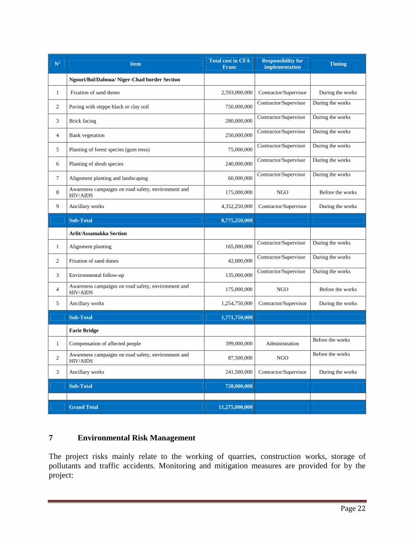
Page 22
N° Item Total cost in CFA
Franc
Responsibility for
implementation Timing
Ngouri/Bol/Daboua/ Niger-Chad border Section
1 Fixation of sand dunes 2,593,000,000 Contractor/Supervisor During the works
2 Paving with steppe black or clay soil 750,000,000 Contractor/Supervisor During the works
3 Brick facing 280,000,000 Contractor/Supervisor During the works
4 Bank vegetation 250,000,000 Contractor/Supervisor During the works
5 Planting of forest species (gum tress) 75,000,000 Contractor/Supervisor During the works
6 Planting of shrub species 240,000,000 Contractor/Supervisor During the works
7 Alignment planting and landscaping 60,000,000 Contractor/Supervisor During the works
8 Awareness campaigns on road safety, environment and HIV/AIDS
175,000,000 NGO Before the works
9 Ancillary works 4,352,250,000 Contractor/Supervisor During the works
Sub-Total 8,775,250,000
Arlit/Assamakka Section
1 Alignment planting 165,000,000 Contractor/Supervisor During the works
2 Fixation of sand dunes 42,000,000 Contractor/Supervisor During the works
3 Environmental follow-up 135,000,000 Contractor/Supervisor During the works
4 Awareness campaigns on road safety, environment and
HIV/AIDS 175,000,000 NGO Before the works
5 Ancillary works 1,254,750,000 Contractor/Supervisor During the works
Sub-Total 1,771,750,000
1 Farie Bridge
1 Compensation of affected people 399,000,000 Administration Before the works
2 Awareness campaigns on road safety, environment and
HIV/AIDS 87,500,000 NGO
Before the works
3 Ancillary works 241,500,000 Contractor/Supervisor During the works
Sub-Total 728,000,000
Grand Total 11,275,000,000
7 Environmental Risk Management
The project risks mainly relate to the working of quarries, construction works, storage of
pollutants and traffic accidents. Monitoring and mitigation measures are provided for by the
project:
Page 23
Barriers to movement: The contractor will at all times maintain traffic flow and access for local
residents to their homes, farms and places of economic activity during works.
Fuel, lubricants and hydrocarbons depots: Fuel, lubricants and hydrocarbons depots as well as
facilities for the maintenance of the company’s equipment must comply with the requirements
for these types of facilities. These facilities should be located over 500 m away from
watercourses; where appropriate, precautions should be taken to waterproof the site and to
contain the facilities in a residual space to prevent the flow of products to surface water.
Safety instructions: (1) measures will also be taken to ensure the safety of local residents: sites
will be marked and identified by signposts in quarry areas and access strictly forbidden to
visitors; (2) in built-up areas, barriers will be erected to prevent the public and unauthorized
persons from entering worksites; (3) worker safety arrangements will be made, including:
wearing of dust masks, gloves and safety footwear; (4) speed limit measures in the two built-up
areas will be taken; and (5) the workers’ camp and the parking area will be lit at night.
Noise-related instructions: The company working in residential areas will as much as possible,
avoid noise during the hours of rest, especially at night. To this end, the company will comply
with the instructions relating to the adjustment of machinery, etc.
Security risk: Owing to developments in northern Mali and the insecurity in Libya, the Agadez
region has become an endemic insecurity area, despite the tireless efforts of the authorities to
maintain a secure environment enabling the implementation of major projects in northern Niger.
In this regard, there is need for vigilance and precautions should be taken in advance because the
project may be compromised by the least insecurity.
8 Surveillance and Monitoring Programme
8.1. The Arlit-Assamaka Road Section in Niger
An environmental surveillance programme is intended to ensure that all commitments and
obligations, including environmental mitigation measures, are applied during the works.
The implementation of this surveillance programme will require the mobilization of several
stakeholders, prominent among which are the General Directorate of Major Works (DGGT) and
the Environmental and Impact Assessment Bureau (BEEEI). Concerning the latter, the
surveillance activities will consist primarily in carrying out control missions on the ground
before and during the construction phase.
It helps to maintain the negative environmental impacts of the project at a low or acceptable
level, and to ensure environmental protection. This environmental surveillance programme
includes, in particular: (a) a list of elements or parameters requiring environmental surveillance;
(b) all the measures and means envisaged for environmental protection; and (c) the obligations of
project owners and contractors regarding the submission of surveillance reports (number,
frequency and contents).
Page 24
The surveillance mechanism will be based on the full participation of the Agadez and Arlit
Regional Directorates responsible for the Environment, supported by their counterparts
responsible for Health, Social Development and Community Development. This will allow for
closer monitoring of the implementation of the environmental clauses and ESMP terms. Thus,
the team, supported by the consulting firm responsible for project supervision, will develop a
timeline on the project duration to ensure compliance with the measures contained in the
technical dossier and the environmental impact assessment report. The BEEEI will organize
periodic missions to ascertain compliance with implementation measures.
Environmental monitoring programme: Monitoring concerns all observation activities and
measures aimed at determining the real impacts of project achievements compared to the impact
projections made during the environmental assessment. The environmental monitoring will make
it possible to acquire data, correct mitigation measures and possibly revise certain environmental
protection standards useful in the development of new asphalted road projects
The data collected during the environmental monitoring exercise will be used to correct the
mitigation measures and possibly revise certain environmental protection standards. The
monitoring programme describes: (a) the environmental components to monitor; (b) actions to be
carried out; (c) monitoring indicators; (d) responsibilities in terms of implementation; (e)
monitoring frequency; and (f) the costs of the exercise.
The programme will run throughout the duration of the project and will be under the
responsibility of BEEEI and DGGT, in accordance with the provisions of Decree No. 2000-
397/PRN/ME/LCD relating to the administrative procedure for assessment and review of
environmental impacts that could be supported by technical ministries through their
decentralized services. Monitoring will focus on water, health and safety, that is to say, on
biophysical and human components, whose impact assessment outcome pointed to a critical need
in terms of the social repercussions and degree of disturbance of the component in question.
8.2. Farié Bridge on River Niger
Environmental surveillance consists in ensuring that the project’s environmental commitments
are honoured. It aims to ensure the effective implementation of the various measures proposed to
mitigate or strengthen, as the case may be, the impacts resulting from the project implementation
and in compliance with legal provisions in force in Niger. The implementation of the
surveillance programme will require the mobilization of several stakeholders, including the
Environmental and Impact Assessment Bureau (BEEEI), the beneficiary population and the
enterprise awarded the works contract. The environmental surveillance programme is detailed in
the ESIA report.
8.3. The Ngouri-Bol-Daboua-Niger Border Road Section (330 km)
Environmental Surveillance Programme: Surveillance is intended to ensure that mitigation
and enhancement measures proposed in the previous section are effectively implemented in each
of the successive project phases and that the applicable regulations are complied with. The
Highways Department, acting through the Environmental Unit, shall be responsible for the
surveillance of the environmental aspects of works. It shall be assisted by the representative of
the Ministry of Environment in the project area.
Page 25
Surveillance primarily involves the participation of a select Technical Committee comprising,
among others, the environmental expertise or social expert responsible for ascertaining the
implementation of the proposed measures and compliance with regulations. The Technical
Committee shall have the power to change the working schedule or methods for the purpose of
achieving protection of the natural and human environments. It goes without saying that it must
have legal status. This Committee shall operate in accordance with Decree No. 2010
630/PR/PM/MEERH/2010 of 4 August regulating environmental impact assessment. The
Technical Committee shall also act as coordinator and consulting engineer as some measures
may require environmental expertise prior to implementation by any of the project stakeholders,
including the government, contractor, MDC and the beneficiaries.
To perform it functions as controller, consultant and coordinator, the Technical Committee will
use such tools as: this environmental impact assessment report (EIAR), detailed plans of the
Massakory-Bol-Niger Border road to be constructed and the regulations in force as well as any
documents it deems necessary for the fulfilment of its tasks. The Technical Committee will
submit a monthly report outlining its activities and the implementation of mitigation and
enhancement measures. This report will mention any environmental problem that occurred
during the reporting period. Surveillance measures will focus on a number of components at
different phases of the project.
“Site Installation” Phase
o Approve the installation plan (drain pan, dumps, storage areas, etc.)
o Inspect workers’ camp (latrine, infirmary, dumps, etc.).
“Works Implementation” Phase
o Control in relation to the intervention plan and technical specifications in
accordance with the worksite process (site log, etc.);
o Verify materials, areas actually affected, quantities implementation;
o Verify the most important points made in the ESMP (environmental and social
measures, indicators);
o Include an “environmental measures” item during site meetings with enterprises;
o Prepare either an environmental report or record;
o Take environmental measures into account during works acceptance.
“Works completion” Phase
o Verify the rehabilitation of borrow pits and quarry sites, the filling of pits,
removal of provisional excavated and backfill material, removal of hulks and
other debris, and general clean-up of worksite;
o Prepare a works completion report;
o Conduct an end-of-mission assessment of the activities carried out and gauge the
effectiveness of the measures and methods used on the worksite to:
Page 26
o Prevent the temporary adverse impact of the works and propose a methodological
framework applicable to similar works sites (feedback).
The Contractor will establish a quality assurance plan (QAP), which will also incorporate
environmental compensation measures. The implementation of the QAP will be supervised by
the mission control and supervision. The executing agencies housed in the Ministry of
Infrastructure (Chad) and the Ministry of Infrastructure (Niger) will be responsible for an
additional verification of the implementation of the ESMP, through their supervision missions. A
complaints log register will be kept in each executing agency and in the CLRT. Each institution
shall establish a log for the time of the complaint and share this information with other agencies.
The mechanism for handling complaints will be determined during the negotiations financing
o
9 Public Consultations and Information Dissemination
9.1. The Arlit-Assamaka Road Section in Niger
The field study concerned the right-of-way area and its environment. It was supplemented by
surveys of local authorities and environmental services in Arlit, as well as a literature review
(previous work) on the project impact area in question.
Local administrative and traditional authorities were finally met to hear their opinions and
expectations about the work. Meetings with the heads of regional and district technical services
also enabled the collection of the necessary data on the project area. Communities have been
consulted since the beginning of the first studies in 2007. They were subsequently consulted
during the process of updating the studies, which took place in April 2013. In addition, the Bank
mission met with representatives from the communities, national authorities and NGOs during
the preparation and appraisal missions that took place in February and June 2013, respectively.
9.2. Farié Bridge on River Niger
The preparation of a road project requires public consultation at the design phase to optimize the
route selection and ensure the acceptability of the road infrastructure in the beneficiary
environment. For this study, the environmental team conducted a field mission from 13 to 16
October 2011 in the project area. The purpose of this mission was to brief the various
stakeholders, particularly the population, elected officials and customary and administrative
authorities on the progress of the feasibility study under which the environmental and
socioeconomic impact assessment was being conducted for the construction of a bridge on River
Niger at Farié and, in return, hear opinions and expectations regarding this project.
The mission met with the executives of the Regional Directorate of the Environment and the
Prefect of Tillabéri, the Mayor and local officials of Kourtheye Rural Commune, divisional
officials in charge of the environment and land, maritime and river transport in Téra, the Prefect
Page 27
of Téra, the Head of Gothèye Administration Post, the Mayor and local officials of Gothèye
Rural Commune, the population of Saya Tallé and Farié Gourma villages (Gothèye Rural
Commune) Bagoumé and Farié Hausa (Kourthèye Rural Commune).
The administrative authorities and especially the mayors and local elected officials were very
insistent on the issue of career management in decentralized communities and the involvement of
communes in the recruitment of local labour, given the experiences in the exploitation of mining
careers in the Arlit area account. In this project, the massive rock quarries will be exploited in
accordance with national legislation. Companies will have to obtain all required licenses before
starting quarrying. They will also develop a security plan which will highlight all the security
measures put in place
The participation of the population in the planning and implementation of Resettlement Plan
Summary is paramount. In this regard, the public consultation was carried out throughout the
study period. In Oactober 2011, consultations, socioeconomic surveys of the household census
and meetings with the Téra Conciliation Commission were conducted. These initiatives afforded
the stakeholders an opportunity to reflect on ways to scrupulously adhere to the various stages
from consultation, start-up of studies to the implementation of the Resettlement Plan Summary.
Decentralized administrative authorities have also conducted a site visit in May 2013, to reassure
people about the imminent start of the work.
Moreover, the Bank conducted a field visit during appraisal in June 2013, with the consultant
and Administration. This visit resulted in participatory meetings with people in villages near the
work site. The discussions helped to define related to realize improvements
9.3. The Bol-Daboua-Niger Border Road Section (330 km)
In this study, the environmental team conducted a field mission from 14 to 23 May 2011 in the
project area. The purpose of the mission was to brief the various stakeholders, particularly the
population, elected officials and customary and administrative authorities on the status of the
study, including the assessment of the environmental and socioeconomic impact of the Project
and, in return, to hear their opinions and expectations regarding the project. Meetings were held
in Ngouri, Bol, Liwa, Rig-Rig and Massakory.
This summary will be posted on the website of the Bank 120 days before the presentation of the
project to the Board of Directors
10 Complementary Initiatives
10.1. The Assamaka-Arlit Road Section in Niger
The project provides for the drilling of four boreholes at 50 km intervals along the road. These
boreholes will help to improve the availability of water along the stretch for road users who
previously had only two water points - one in Arlit and the other in Assamaka. The project also
includes the construction of two docks designed to load and unload livestock. The total costs
related to these facilities amounted to 1.25 billion FCFA
Page 28
The project also provides for a road safety and HIV/AIDS communication programme as well as
a capacity building programme comprising a workshop on environmental monitoring to support
local technical services.
10.2. Farié Bridge on River Niger
In addition to a road safety and quarry exploitation communication programme, the project
includes the following complementary initiatives: the rehabilitation of two schools, a health
center, the construction of a market and two boreholes managed by solar water pump. The costs
of these related facilities amounted to 242 million
10.3. The Ngouri-Bol-Daboua-Niger Border Road Section (330 km)
The project plans to raise awareness about health, STIs and AIDS. Educating the public on road
safety will devolve on NGOs or relevant structures. These awareness campaigns will be
conducted by NGOs, preferably local. The project includes complementary activities designed to
improve the living conditions of the affected communities. These activities are: the rehabilitation
of 100 km of rural roads to open up areas of agricultural output and weekly markets, the
rehabilitation of three schools and three health facilities, the building of 15 docks and unloading
animals, the construction of 20 wells managed with solar water pump. The estimated costs of the
this initiatives amountsto FCFA 4.35 billion FCFA
11 Conclusion
The construction of the Trans-Sahara Highway is a project of national importance in that it
contributes to the opening up of Niger and Chad. It promotes socioeconomic development
through the opportunities it offers in terms of the marketing of agro-pastoral products, ease of
transportation of goods between the port of Algiers and the northern part of the country, the
comfort of travelling and medical evacuations.
However, the road is not without negative impact on the physical environment and the lifestyle
of the local population. The main negative impact is the moral depravity that could result from
the contact between this population and an ever-growing number of travellers from diverse
backgrounds. The permanent contact between natives and non-natives could also foster the
spread of STIs/HIV/AIDS.
The integration of environmental considerations into the planning, design and construction of
road projects is necessary to maximize the benefits for the population and reduce the negative
impacts for generations to come. The project evaluation will be facilitated by surveillance and
the environmental and social monitoring of the actual short- and medium-term impacts of
operating the road.
Page 29
Moreover, during its construction and operation, the Farié Bridge will generate obvious positive
impacts for the benefit of the population of the area and the country at large. It will foster sub-
regional integration by promoting trade. The expected positive economic, social and security
impacts are considerable. The project will also have a negative impact on components of the
biophysical and human environment highlighted by this study. The effect of works-related
earthworks on the vegetation cover will be negligible. A compensation and redeployment
scheme will be put in place for ferry workers whose activities will decline as a result of the
project.
12 References and Contacts
In drafting this summary, the following documents were consulted
- ESIA of the Arlit-Assamaka road (border of Algeria), June 2013;
- ESIA of the Farié Bridge on River Niger, March 2012;
- Resettlement Plan Summary for the Farié Bridge on River Niger, June 2012;
- ESIA of the Massakory-Bol-Niger Border road, August 2011 (update of the 2005
study).
Page 30
CONTACTS:
African Development Bank
Mr MEGNE EKOGA, JEAN PATERNE, Senior Transport Economist, Department of Transport
and Information Technology, African Development Bank, P.O. Box 323 - 1002 Tunis Belvédère,
Tunisia, Tel: +216 71 10 3442, E-mail: [email protected]
Ms Awatef SIALA FOURATI, Principal Environmental Officer, Department of Energy, the
Environment and Climate Change, African Development Bank, P.O. Box 323 - 1002 Tunis
Belvédère, Tunisia, Tel: +216 71 10 3854, E-mail: [email protected]
M. Jean-Pierre KALALA, Principal Socio-economist Department of Transport and Information
Technology, African Development Bank, P.O. Box 323 - 1002 Tunis Belvédère, Tunisia, Tél :
+216 71 10 3561, Email : [email protected]