Embed Size (px)
Citation preview

Latchmore Wetland RestorationEnvironmental Statement: Non-Technical Summary
Prepared by LUC and associated Sub-Consultants
July 2016

Latchmore Wetland Restoration
Project Title: Latchmore Wetland Restoration: Environmental Statement, Non-Technical Summary
Client: Forestry Commission
Version Date Version Details Prepared by Checked by Approved by
Director
V0 11/12/15 1st Draft Ben Miller and Jonny Hill
Emma Luke Sarah Young
V1 14/06/2016 Final Draft Jonny Hill Philip Smith Sarah Young
Planning & EIA Design Landscape Planning Landscape Management Ecology Mapping & Visualisation
LUC BRISTOL 12th Floor Colston Tower Colston Street Bristol BS1 4XE T +44 (0)117 929 1997 [email protected]
Offices also in: London Glasgow Edinburgh
FS 566056 EMS 566057
Land Use Consultants Ltd Registered in England Registered number: 2549296 Registered Office: 43 Chalton Street London NW1 1JD LUC uses 100% recycled paper
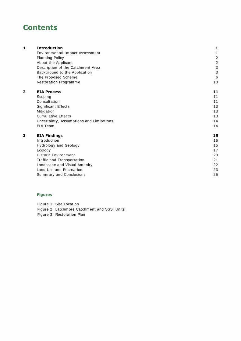
Contents
1 Introduction 1 Environmental Impact Assessment 1 Planning Policy 2 About the Applicant 2 Description of the Catchment Area 3 Background to the Application 3 The Proposed Scheme 6 Restoration Programme 10
2 EIA Process 11 Scoping 11 Consultation 11 Significant Effects 13 Mitigation 13 Cumulative Effects 13 Uncertainty, Assumptions and Limitations 14 EIA Team 14
3 EIA Findings 15 Introduction 15 Hydrology and Geology 15 Ecology 17 Historic Environment 20 Traffic and Transportation 21 Landscape and Visual Amenity 22 Land Use and Recreation 23 Summary and Conclusions 25
Figures
Figure 1: Site Location Figure 2: Latchmore Catchment and SSSI Units Figure 3: Restoration Plan


Latchmore Wetland Restoration: Non-Technical Summary 1 July 2016
1 Introduction
1.1 The Forestry Commission (FC) is applying to the New Forest National Park Authority (NFNPA) for planning permission to undertake a wetland restoration in the New Forest National Park in Hampshire. Known as the Latchmore Wetland Restoration project (referred to herein as the ‘project’), the site is located close to Frogham and Ogdens to the southwest and Fritham to the east (see Figure 1).
1.2 The Town and Country Planning (Environmental Impact Assessment) (England and Wales) Regulations 2011 (as amended 2015), SI No. 1824 (hereafter referred to as the EIA Regulations) list development types within Schedule 1 and Schedule 2 which will and may require EIA respectively. The project is not classified as any of the development types within Schedule 1 and Schedule 2 of the EIA Regulations. Although an EIA was also not deemed necessary by the NFNPA, Natural England requested that an EIA was undertaken. The FC therefore volunteered to undertake an EIA and produce an Environmental Statement (ES) to accompany the planning application. This non-technical summary forms part of the ES; it provides a summary of the ES and its conclusions.
1.3 The wetland restoration proposals were developed taking into account discussions with a wide range of consultees, including: local residents; the planning authority; statutory bodies such as Natural England; and other interested organisations.
Environmental Impact Assessment
1.4 The purpose of EIA is to compile, evaluate and present the potential significant environmental
effects resulting from a proposed development to assist the planning authority, statutory consultees and the wider public when considering an application. This is undertaken through establishing the existing characteristics of the area likely to be affected by the development, known as the baseline, and then assessing the potential environmental effects of the development, noting whether they are beneficial or adverse.
1.5 Where possible, potential adverse effects are avoided or minimised through the design process undertaken throughout the EIA. Early identification of potentially significant environmental effects also enables mitigation measures to be identified to avoid, reduce and offset significant environmental effects. Any residual environmental effects i.e. those remaining following implementation of the mitigation measures, are then identified.
1.6 National Planning Policy Guidance states that:
“The aim of Environmental Impact Assessment is to protect the environment by ensuring that a local planning authority when deciding whether to grant planning permission for a project, which is likely to have significant effects on the environment, does so in the full knowledge of the likely significant effects, and takes this into account in the decision making process…The aim of Environmental Impact Assessment is also to ensure that the public are given early and effective opportunities to participate in the decision making procedures”1.
1.7 It goes on to state that:
“Whilst every Environmental Statement should provide a full factual description of the development, the emphasis of Schedule 4 is on the “main” or “significant” environmental effects to which a development is likely to give rise. The Environmental Statement should be proportionate and not be any longer than is necessary to assess properly those effects”2.
1 NPPG Paragraph 002 Reference ID: 4-002-20140306. 2 NPPG Paragraph 033 Reference ID: 4-033-20140306.

Latchmore Wetland Restoration: Non-Technical Summary 2 July 2016
1.8 The process undertaken, methods used and findings of the EIA are presented in the ES. This summary presents the main findings in non-technical language. A brief summary of the EIA process is provided in Section 2 and the assessment methods used and findings are described in Section 3.
Planning Policy
1.9 The proposed project is located within the New Forest National Park, and the NFNPA is required to determine the planning application in accordance with their Development Plan and associated planning policies as set out in the New Forest National Park Authority Core Strategy and Development Management Policies Development Plan Document (DPD) (2010).
1.10 Other material considerations that will be taken into account when the planning application is determined include:
The National Planning Policy Framework (NPPF)3 (2012) which sets out the national environmental, social and economic planning policies for England.
National Planning Practice Guidance (PPG) (2014) a web-based resource4 that accompanies the NPPF.
About the Applicant
1.11 The FC manages the nation’s forest estate to provide environmental, social and economic benefits and is the government department responsible for protecting, expanding and promoting the sustainable management of woodland and increasing their value to society and the environment. The FC manages the Crown Lands in the New Forest.
1.12 The FC is a partner in the New Forest Higher Level Stewardship (HLS) Scheme, which is managed through a formal partnership between the Verderers of the New Forest, the FC and the NFNPA. The New Forest HLS is England’s largest agri-environment scheme designed to restore and enhance the internationally important habitats in the New Forest. The Scheme funds:
the maintenance and restoration of internationally important habitats for wildlife;
the historic practice of commoning, which maintains the unique New Forest landscape;
work to identify and maintain historic sites to improve their protection;
improved access to and education about the area’s unique environment.
1.13 One of the key objectives of the New Forest HLS Scheme is wetland restoration. The HLS Scheme seeks to safeguard areas that are recognised as being of outstanding importance for nature conservation in both the UK and Europe due to the size, quality and complex mosaic of habitats. The Latchmore Wetland Restoration is being funded by the New Forest HLS Scheme and by FC core funding.
3 Department of Communities and Local Government (March 2012) National Planning Policy Framework. 4 http://planningguidance.planningportal.gov.uk

Latchmore Wetland Restoration: Non-Technical Summary 3 July 2016
Description of the Catchment Area
1.14 Latchmore Brook, a tributary of the River Avon, flows through the New Forest National Park. The Brook rises in Picket Corner and Crow’s Nest Bottom, draining west towards Ogdens (south of
Frogham) where it becomes known as the Huckles Brook. The catchment area of Latchmore Brook includes 27 Sites of Special Scientific Interest5 (SSSIs); one of which is also noted for its geological interest (Studley Wood SSSI Unit 58). Latchmore Brook extends through three forested Inclosures: Islands Thorns Inclosure (SSSI Unit 540), Amberwood Inclosure (which are ‘thrown open’ Inclosures6) and Alderhill Inclosure (SSSI Unit 66); before entering the Open Forest. Drains within Sloden Inclosure (SSSI Units 541 and 61) also flow into Latchmore Brook.
1.15 The catchment also includes the mire catchments of Claypits Bottom (SSSI Unit 30), Thompson’s
Castle (SSSI Unit 43), Latchmore Mire (SSSI Unit 44), Watergreen Bottom (SSSI Unit 49), and Ogdens Mire (SSSI Unit 50), whilst Latchmore Shade (SSSI Unit 48) (along the watercourse itself) includes wet heath and lawn habitats including SSSI Unit 28. The catchment also includes 15 SSSI Units (Units 29, 31, 45, 46, 47, 53, 54, 55, 59, 60, 253, 255, 258, 259 and 542) within which restoration works are not proposed. Latchmore Brook flows in a straightened, widened and deepened drain channel for much of its length across Latchmore Shade, before leaving the western edge of the Open Forest at Ogdens.
1.16 The Brook’s catchment includes open habitats (particularly in the lower sections of the catchment) such as dry heath, wet heath, mire and grassland. Woodland is dominant across the centre of the catchment particularly in the Inclosures and towards its head, and includes coups of semi-natural broadleaved woodland, as well as planted conifers and broadleaves.
1.17 A map showing the entire hydrological catchment area of the Latchmore Brook and the SSSI Units is provided in Figure 2 and Figures 4.14 and 4.15 in Volume 2: Environmental Statement.
1.18 The main land uses are forestry and grazing, particularly in the lower sections of the site (mainly by ponies and cattle). The site is also well used for informal recreation such as walking, cycling and horse riding.
Background to the Application
1.19 The FC is proposing to undertake the wetland restoration works at Latchmore, as the existing watercourse through the Latchmore catchment area is unstable with areas of increased erosion and deposition along its length due to the impacts of historical artificial drainage and river engineering works7. These works took place in the mid-19th century and early 20th century and included channel straightening and widening, and the creation of side channels to improve drainage in the planted areas. These works have had several adverse effects, as outlined below, which over time has led to the increased erosion and has meant that the Brook has become more disconnected from the floodplain8. The proposed wetland restoration works are seeking to restore the Brook to its natural, meandering state, reduce erosion of the stream banks and bed, and prevent the drying out of the surrounding ground.
1.20 The impacts of this historical artificial drainage work include:
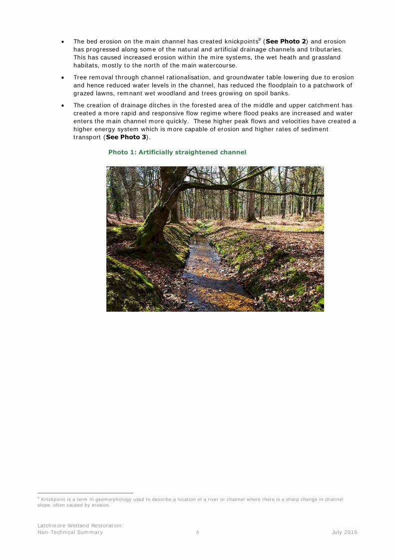
The sections of channel that have been artificially straightened (See Photo 1) have experienced an increased channel slope and hence higher bed velocities and increased erosion of the river bed with reduced channel habitat diversity.
This channel incision has led to lower channel water levels and more limited seasonal flooding of the grassland and woodland habitats on the surrounding floodplain.
5 SSSI’s are a nature conservation designation denoting a protected area in the United Kingdom noted for its biological or geological importance. 6 Thrown Open Inclosures are Inclosures from which grazing stock are not currently excluded, although the Forestry Commission still reserve the right to exclude stock in order to meet management objectives when required. 7 As stated in Chapter 1: JBA consulting (April 2013) New Forest SSSI Geomorphological Survey Overview. 8 As stated in Chapter 4 in: JBA consulting (April 2013) New Forest SSSI Geomorphological Survey Overview.
Latchmore Wetland Restoration: Non-Technical Summary 4 July 2016
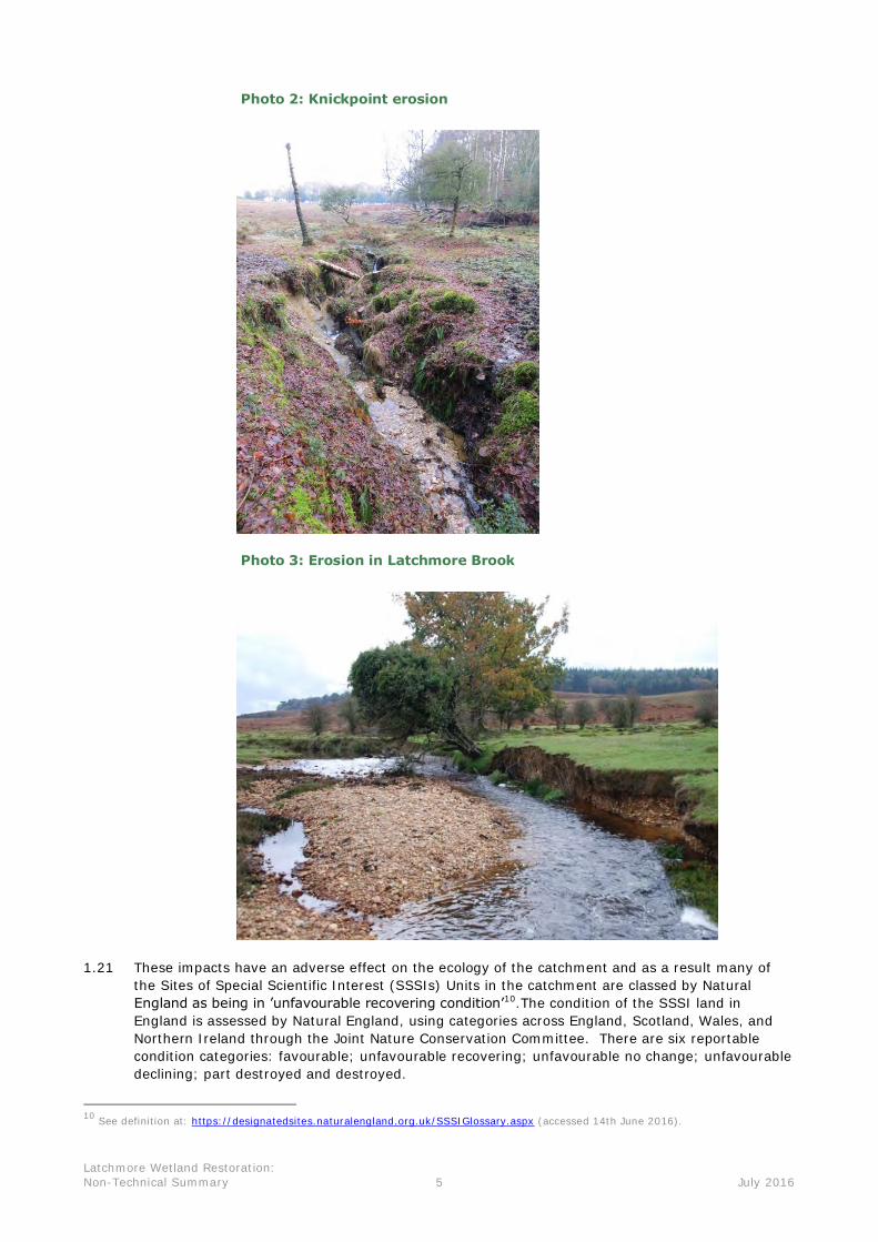
The bed erosion on the main channel has created knickpoints9 (See Photo 2) and erosion has progressed along some of the natural and artificial drainage channels and tributaries. This has caused increased erosion within the mire systems, the wet heath and grassland habitats, mostly to the north of the main watercourse.
Tree removal through channel rationalisation, and groundwater table lowering due to erosion and hence reduced water levels in the channel, has reduced the floodplain to a patchwork of grazed lawns, remnant wet woodland and trees growing on spoil banks.
The creation of drainage ditches in the forested area of the middle and upper catchment has created a more rapid and responsive flow regime where flood peaks are increased and water enters the main channel more quickly. These higher peak flows and velocities have created a higher energy system which is more capable of erosion and higher rates of sediment transport (See Photo 3).
Photo 1: Artificially straightened channel
9 Knickpoint is a term in geomorphology used to describe a location of a river or channel where there is a sharp change in channel slope, often caused by erosion.
Latchmore Wetland Restoration: Non-Technical Summary 5 July 2016
Photo 2: Knickpoint erosion
Photo 3: Erosion in Latchmore Brook
1.21 These impacts have an adverse effect on the ecology of the catchment and as a result many of the Sites of Special Scientific Interest (SSSIs) Units in the catchment are classed by Natural England as being in ’unfavourable recovering condition’10.The condition of the SSSI land in England is assessed by Natural England, using categories across England, Scotland, Wales, and Northern Ireland through the Joint Nature Conservation Committee. There are six reportable condition categories: favourable; unfavourable recovering; unfavourable no change; unfavourable declining; part destroyed and destroyed.
10 See definition at: https://designatedsites.naturalengland.org.uk/SSSIGlossary.aspx (accessed 14th June 2016).

Latchmore Wetland Restoration: Non-Technical Summary 6 July 2016
1.22 The FC has a legal responsibility under the EU Habitats Directive/ Wildlife and Countryside Act 1981 (as amended by the Countryside and Rights of Way Act 2000) to restore habitats in a Special Area of Conservation (SAC)/ Site of Special Scientific Interest (SSSI) where the habitat has been assessed by Natural England as being in ‘unfavourable recovering condition’.
1.23 It is important to note that Natural England has identified the SSSI Units in the Latchmore Brook catchment as being ‘recovering’ due to the Latchmore Wetland Restoration project which is
proposed by the FC. If the restoration is not implemented the SSSI Units will revert to being classed as ‘unfavourable no change’11 or ‘unfavourable declining’.12
1.24 This scheme seeks to improve the condition of the SSSI Units and the New Forest SAC and is in line with the New Forest Wetland Management Plan 2006-201613 which seeks to “ensure the
continued long term sustainability and integrated management of water-courses and wetland
habitats” which “will prevent further decline of SAC habitats and bring them into favourable
condition”.
The Proposed Scheme
1.25 The project will include work activity in 12 SSSI Units: 28, 30, 43, 44, 48, 49, 50, 58, 6114, 66, 540 and 541. Table 1.1 outlines the proposed works that will be undertaken and why the work is needed:
Table 1.1: Proposed restoration works
Proposed works
What will it involve? Why is it needed?
1. Tree felling, scrub and vegetation clearance
Removal of required trees, scrub, and vegetation.
To provide access to undertake the works.
To enable ordnance clearance to be undertaken if required.
2. Meander Restoration
Excavation and recreation of the old brook meanders and diversion of the Latchmore Brook from the existing drainage channels into the restored meanders.
To reduce flow rates and erosion in the Brook (by increasing the length of the channel and therefore reducing the gradient).
To restore channel stability.
To improve connectivity with the floodplain.
6 Unfavourable no change - The unit/feature is not being conserved and will not reach favourable condition unless there are changes to the site management or external pressures and this is reflected in the results of monitoring over time, with at least one of the mandatory attributes not meeting its target (as set out in the site specific FCT) with the results not moving towards the desired state. The longer the SSSI unit remains in this poor condition, the more difficult it will be, in general, to achieve recovery. At least one of the designated feature(s) mandatory attributes and targets (as set out in the site specific FCT) are not being met. 12 Unfavourable declining – The unit/feature is not being conserved and will not reach favourable condition unless there are changes to site management or external pressures. The site condition is becoming progressively worse, and this is reflected in the results of monitoring over time, with at least one of the designated features mandatory attributes not meeting its target (as set out in the site specific FCT) with the results moving further away from the desired state. The longer the SSSI unit remains in this poor condition, the more difficult it will be, in general, to achieve recovery. See definition at: https://designatedsites.naturalengland.org.uk/SSSIGlossary.aspx (accessed 14th June 2016). 13 New Forest Wetland Management Plan 2006 – 2016. Retrieved from: http://www.hlsnewforest.org.uk/hls/downloads/download/8/new_forest_wetland_management_plan_2006-2016 on 14th June 2016. 14 Restoration works are not proposed to be undertaken in Unit 61 but access through the SSSI unit will be required to undertake the works in SSSI Unit 49.
Latchmore Wetland Restoration: Non-Technical Summary 7 July 2016
Proposed works
What will it involve? Why is it needed?
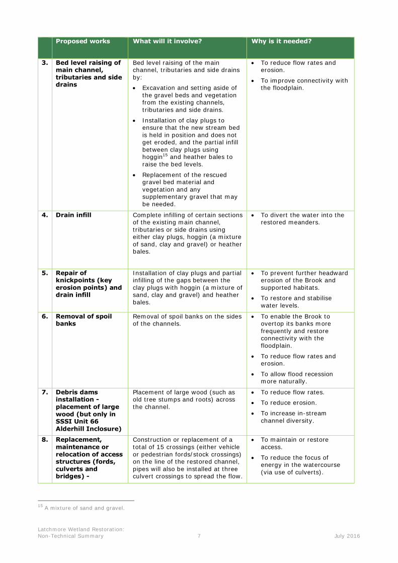
3. Bed level raising of main channel, tributaries and side drains
Bed level raising of the main channel, tributaries and side drains by:
Excavation and setting aside of the gravel beds and vegetation from the existing channels, tributaries and side drains.
Installation of clay plugs to ensure that the new stream bed is held in position and does not get eroded, and the partial infill between clay plugs using hoggin15 and heather bales to raise the bed levels.
Replacement of the rescued gravel bed material and vegetation and any supplementary gravel that may be needed.
To reduce flow rates and erosion.
To improve connectivity with the floodplain.
4. Drain infill Complete infilling of certain sections of the existing main channel, tributaries or side drains using either clay plugs, hoggin (a mixture of sand, clay and gravel) or heather bales.
To divert the water into the restored meanders.
5. Repair of knickpoints (key erosion points) and drain infill
Installation of clay plugs and partial infilling of the gaps between the clay plugs with hoggin (a mixture of sand, clay and gravel) and heather bales.
To prevent further headward erosion of the Brook and supported habitats.
To restore and stabilise water levels.
6. Removal of spoil banks
Removal of spoil banks on the sides of the channels.
To enable the Brook to overtop its banks more frequently and restore connectivity with the floodplain.
To reduce flow rates and erosion.
To allow flood recession more naturally.
7. Debris dams installation - placement of large wood (but only in SSSI Unit 66 Alderhill Inclosure)
Placement of large wood (such as old tree stumps and roots) across the channel.
To reduce flow rates.
To reduce erosion.
To increase in-stream channel diversity.
8. Replacement, maintenance or relocation of access structures (fords, culverts and bridges) -
Construction or replacement of a total of 15 crossings (either vehicle or pedestrian fords/stock crossings) on the line of the restored channel, pipes will also be installed at three culvert crossings to spread the flow.
To maintain or restore access.
To reduce the focus of energy in the watercourse (via use of culverts).
15 A mixture of sand and gravel.

Latchmore Wetland Restoration: Non-Technical Summary 8 July 2016
1.26 Further detailed information outlining the activity and method statement for all of the works outlined in Table 1.1 above are presented in Chapter 4: Project Description and Design of Volume 1: Environmental Statement, and illustrated on Figures 4.5 – 4.13 in Volume 2:
Environmental Statement.
Material Delivery Routes/Catchment Access
1.27 Material that will be used in the restoration works, including hoggin, washed gravels, clay and heather bales, will be transported to the Latchmore Catchment by four routes from the main roads (the A338 and A31) in the area. The four routes are listed in Table 1.2 and are illustrated on Figure 4.16 in Volume 2: Environmental Statement.
Table 1.2: Summary of material delivery routes
Route Name Detailed Route Years route will be
used
Ogdens Along the A338, turning at Ellingham Drove, left at Moyles Court, north along Gorley Road to South Gorley, and right to Ogdens.
2017, 2018, 2020
Alderhill A31 Stoney Cross, via FC roads over Broomy Plain and Broomy Inclosure.
2019, 2020
Fritham Either: Along the A31, taking the B3079 and then the
B3078, left at Longcross, right towards Fritham, through Fritham village, past the Royal Oak Public House, and left into the forest car park with track to Islands Thorns Inclosure; or
along the A338, joining the B3078, right at Longcross, right towards Fritham, through Fritham village, past the Royal Oak Public House, and left into the forest car park with track to Islands Thorns Inclosure.
2017, 2019
Telegraph
Hill
Either: Along the A31, taking the B3079 and then the
B3078, turning left at Telegraph Hill; or along the A338, joining the B3078, turning
right at Telegraph Hill.
2017, 2018
Catchment Infrastructure
Stockpile locations
1.28 Nine stockpile locations will be used for the proposed works (see Figure 3). Material will be delivered to the stockpile locations before being moved to the proposed work areas. A summary of these stockpile locations and the delivery routes (as outlined above) that will be used to transport material to these locations is provided in Table 1.3 below.

Latchmore Wetland Restoration: Non-Technical Summary 9 July 2016
Table 1.3: Stockpile Locations and Delivery Routes
Stockpile Location Delivery Route
1. Ogdens Mire Ogdens
2. Ogdens Car Park Ogdens
3. Hampton Ridge Telegraph Hill
4. Alderhill Inclosure Alderhill
5. Sloden Inclosure Alderhill
6. Fritham Bridge Fritham
7. Islands Thorns Fritham
8. Picket Corner Telegraph Hill
9. Claypits Telegraph Hill
Proposed Tracks/Routes within the Latchmore Catchment
1.29 The material delivery vehicles will access the stockpile locations via existing FC tracks. These are labelled as ‘existing access tracks’ on Figure 3. These tracks are already in a condition that is fit for use by both the material delivery vehicles and restoration work vehicles.
1.30 Restoration work vehicles will access the stockpile locations and restoration work areas via the ‘existing access tracks’ and ‘proposed access routes’ (see Figure 3). The proposed access routes are not existing tracks and have not been used by restoration works vehicles before, they include existing undisturbed ground. These access routes will either travel within the existing watercourses (once dry) or run adjacent to them, as illustrated in Figure 3. If necessary ‘bog
matting’ will be laid in any areas that appear vulnerable to erosion and disturbance. Upon
completion of the works in the relevant area, all access routes will be restored to a state that encourages vegetation re-colonisation, thereby reinstating the area.
1.31 The proposed access routes are illustrated on Figure 3 by 20 metre wide strips. The proposed access routes will only be 4 metres wide when used, however, it is not yet known what exact path the 4 metre wide access routes will take within the 20 metre wide strips. The exact path the access routes will take will be decided between the FC and contractors prior to the restoration works being undertaken and will be informed by:
A qualified ecologist from the FC will be present during the restoration phase. The ecologist will provide advice on micro-siting the track locations in the proposed access routes to avoid sensitive habitats.
An on-going programme of archaeological monitoring (Watching Brief) where necessary, during ground intrusive works.
The findings of an ordnance survey that will be undertaken along the proposed access routes prior to works being undertaken. The site used to form part of a World War II practice range.
Latchmore Wetland Restoration: Non-Technical Summary 10 July 2016
Restoration Programme
1.32 Table 1.4 outlines the proposed restoration programme for each sub-area where the works will take place. The works will be undertaken in short stages (of up to 12 weeks) in the summer, over a four year period (2017 – 2020). There is the potential that problems may be encountered during the restoration works that cannot be expected, e.g. wet weather which may suspend the works for a number of days. Therefore, the timings given for the restoration of each site have had additional time included to allow for this. Table 1.4 therefore presents a worst case scenario for the duration of the restoration works.
Table 1.4: Indicative Restoration Programme
Year Months Work area
2017
July - September Islands Thorns (Picket Corner to Fritham Bridge)
September Thompson's Castle
September Latchmore Mire
2018 August - September Studley Wood
Mid-August - September Ogdens Mire
2017 July - September Amberwood and Alderhill Inclosures
August - September Sloden
2020 August - September Watergreen Bottom
August – September Latchmore Shade

Latchmore Wetland Restoration: Non-Technical Summary 11 July 2016
2 EIA Process
2.1 This section outlines the EIA process and in particular: the scope of the EIA; the consultation undertaken; the assessment of significant and cumulative effects; and the EIA team.
Scoping
2.2 The Institute of Environmental Management and Assessment (IEMA) guidelines16 describe the
process of scoping as identifying the issues to be addressed by an EIA. It is a method of ensuring that an EIA focuses on the important issues and avoids those that are considered to be less significant. Scoping also provides a means to discuss methods of impact assessment and to reach agreement on those which are most appropriate.
2.3 A Scoping Report was submitted to the NFNPA in August 2014. The Scoping Report set out the potential environmental effects that could result from the Latchmore Wetland Restoration, and the assessment process by which these issues were to be evaluated. The NFNPA’s internal specialist teams and other statutory and non-statutory consultees were consulted on the contents of the report. A Scoping Opinion detailing the results of the consultation was issued by the NFNPA in October 2014 and was used to inform the final scope of the EIA. A copy of this Scoping Opinion is provided in Appendix 2.3 in Volume 1: Environmental Statement.
Consultation
2.4 The FC undertook extensive pre-application consultation with regard to the proposed scheme. It has in place a Protocol for Consultation and Approval of SSSI Restoration Works on the Open Forest during the New Forest HLS (Higher Level Stewardship) Scheme which applies to Latchmore. Draft restoration proposals were circulated to Natural England, New Forest National Park Authority (NPA), Commoners Defence Association, New Forest Association, Verderers and Agisters following site visits. The draft restoration proposals provided a description of why the SSSI Units are in unfavourable condition; what work is necessary to meet the Natural England criteria for a favourable condition; annotated maps of the sites were provided listing the key points for discussion and a written summary of what was proposed.
EIA Consultations with Statutory and Non-Statutory Consultees
2.5 In terms of the EIA, in addition to the formal scoping exercise, meetings and other consultations were carried out with a number of statutory and non-statutory consultees during the EIA process. Consultees and the approach to consultation were outlined in the Latchmore Restoration Planning Application: Consultation and Communication Strategy17 from the outset of the EIA process. The document outlined how LUC planned to engage with stakeholders during the preparation of the planning application and as part of the EIA process. Consultees included Natural England, Environment Agency, NFNPA, Hyde Parish Council and the Friends of Latchmore.
2.6 The purpose of these consultations was threefold:
to provide progress updates on the assessments being undertaken;
to enable any potential issues or concerns raised to be discussed at an early stage;
to ensure that the assessment process was transparent.
16 Institute of Environmental Management and Assessment (IEMA) (2004, plus 2006 updates) Guidelines for Environmental Impact Assessment. 17 Available at: http://www.hlsnewforest.org.uk/downloads/download/31/latchmore_wetland_restoration_planning_application_consultation_strategy retrieved on 14th June 2016

Latchmore Wetland Restoration: Non-Technical Summary 12 July 2016
2.7 Details of these consultations are provided in the relevant topic chapters of the ES (Chapters 6-
11 in Volume 1: Environmental Statement).
Public Engagement
2.8 A full summary of the public engagement is provided in the Planning Statement submitted as part of the application. In brief, the public engagement comprised several stages as described below.
2.9 An initial public exhibition was held close to the location of the proposed restoration works:
Tuesday 29th April 2014, 4pm – 8.30pm, Godshill Village Hall.
2.10 The exhibition provided an opportunity for local people to discuss the EIA and the key issues it would cover with members of the EIA team and FC. Exhibition attendees were encouraged to complete a feedback form, which was available at the exhibition and online. A summary of the feedback along with comments from the EIA team regarding how comments had been/would be addressed was circulated to all exhibition attendees and posted on the project website18.
2.11 Following finalisation of the design/restoration measures and completion of the baseline surveys/assessment, a further exhibition was held close to the location of the proposed restoration works:
Tuesday 6th October 2015, 4pm- 8.30pm, Hyde Church Community Centre.
2.12 The exhibition updated members of the public on the nature of the proposed works and provided a summary of the key findings of the EIA. Exhibition attendees were encouraged to ask questions about the scheme and to complete a feedback form, which was available at the exhibition and online. Again specialist FC staff members as well as representatives of the EIA project team were on hand to answer questions.
2.13 A summary of feedback along with comments from the EIA team regarding how comments had been addressed was circulated to all exhibition attendees and posted on the project website19.
2.14 In addition to the above, the following public engagement was undertaken:
1. Wider advertisement for each public exhibition, including press releases, newspaper adverts, posters and emails.
2. A website maintained for the project with regular updates provided and key documents uploaded: http://www.hlsnewforest.org.uk/info/100/latchmore.
3. Dedicated email address for stakeholders to write to: [email protected].
4. Replies to direct queries from local residents and key stakeholders provided in letter and email format, or on the project website and by telephone as required.
2.15 Correspondence with local residents and key stakeholders will be on-going to ensure all parties are kept up to date as the scheme progresses.
2.16 As outlined above, a summary of the responses provided by the statutory and non-statutory consultees and the account taken of their responses is provided in the relevant topic chapters of the ES.
18 Available at: http://www.hlsnewforest.org.uk/info/100/latchmore retrieved on 14th June 2016 19 Available at: http://www.hlsnewforest.org.uk/info/100/latchmore retrieved on 14th June 2016

Latchmore Wetland Restoration: Non-Technical Summary 13 July 2016
Significant Effects
2.17 The focus of an EIA should be on the likely significant environmental effects associated with the proposed development. The judgement on what is a ‘significant’ environmental effect is crucial in
informing the decision-making process. However, defining what is considered to be ‘significant’ can be complex.
2.18 For each environmental topic, definitions have been provided for what are considered to be significant effects, taking into account the sensitivity of the environmental receptor to change, and the magnitude (size) of the predicted change. All the assessments take account of best practice and guidelines.
2.19 The significance of likely effects occurring as a result of the wetland restoration has been categorised, where possible, as major, moderate, minor or negligible. Effects categorised as
major or moderate are considered to be ‘significant’ in the context of the EIA
Regulations. In line with good practice guidance developed by Chartered Institute for Ecology and Environment Management (CIEEM), the ecology section does not state whether effects are of major, moderate, minor or negligible significance. Instead it states whether the effects are significant or not significant and at what geological scale – international, national, regionally, county, local or site level.
Mitigation
2.20 The Regulations require mitigation measures to be included in an ES. These are the measures (in order of priority) to avoid, reduce, remedy or compensate for any significant adverse effects. Effects before and after proposed mitigation (residual effects) are clearly stated within each topic chapter. This demonstrates the extent to which adverse effects are avoided or reduced.
Cumulative Effects
2.21 It is important to consider the possible effects that the proposal may have in combination with existing or consented projects or activities, and where practicable other projects in planning. The EIA Regulations state that types of effect identified “should cover the direct effects and any
indirect, secondary, cumulative, short, medium and long-term, permanent and temporary,
positive and negative effects.” The Planning Practice Guidance – Environmental Impact Assessment20, gives further advice in relation to cumulative effects, stating that “local planning
authorities should always have regard to the possible cumulative effects with any existing or
approved development.”
2.22 There are two types of cumulative effects that should be considered in EIA – Type 1 Cumulative effects (which is about the interaction between effects associated with a proposed project) and Type 2 cumulative effects – (the interaction between different projects).
2.23 Type 1 cumulative effects have been assessed in the ES by considering the interrelationship between effects – e.g. ecology and hydrology. Separate sections have been included within each of the topic chapters (Chapters 6-11 in Volume 1: Environmental Statement) to cover this.
2.24 In relation to Type 2 cumulative effects, the NFNPA requested consideration of four projects:
Ditchend and Pound Bottom Landfill – these are schemes which have either been completed – (e.g. Ditchend) or are existing (e.g. Poundhill). Both of these schemes exist within the current baseline so a separate cumulative assessment was not required. For example, information has been obtained on traffic flows along the relevant local roads, therefore any existing vehicle movements associated with the landfill have been picked up as part of those figures. As Ditchend is in a separate catchment and the scheme has been completed, there is no potential for any significant cumulative effects to occur.
20 See: http://planningguidance.planningportal.gov.uk/blog/guidance/environmental-impact-assessment/ retrieved on 14th June 2016.

Latchmore Wetland Restoration: Non-Technical Summary 14 July 2016
Dockens Water – It is understood that the EA were planning to do works in this catchment but that is no longer the case.
Hale Purlieu - This is a project being proposed by National Grid and involves the undergrounding of approximately 3km of overhead line at Hale Purlieu. The planning application for this project will require an EIA. The project is still at an early stage of development and no information is available on how many vehicle movements etc. will be required and what access routes these vehicles will take. In the absence of this information, it is not possible to undertake a cumulative assessment of this project. It will be for the National Grid to undertake a cumulative assessment as part of their EIA, considering the cumulative effects of the Latchmore proposal. This is a standard and accepted approach within EIA.
2.25 In light of the above, a Type 2 cumulative assessment is not required for the Latchmore EIA. This approach has been confirmed through correspondence with the planning officers at NFNPA.
Uncertainty, Assumptions and Limitations
2.26 The EIA process is designed to enable informed decision-making based on the best possible information about the environmental implications of a proposed development. Any uncertainties or limitations are specifically set out in the ES topic chapters. Despite the inherent uncertainty in relation to some topic areas, it is considered the ES contains adequate information to assess the likely significant effects of the proposed development.
EIA Team
2.27 This ES was compiled by LUC on behalf of FC. LUC is a registered practitioner with the Institute of Environmental Management and Assessment (IEMA) and has secured the IEMA EIA Quality Mark. This provides assurance to third party stakeholders that an objective EIA has been carried out according to the IEMA Code of Practice and by experienced professionals. LUC had overall responsibility for the ES, and sub-consultants undertook specialist assessments where necessary.
2.28 The topic specialists included:
Cascade Consulting, a Practice of Ricardo Energy and Environment (hydrology; macro-invertebrate; otters; and river habitat survey).
Footprint Ecology (breeding birds and overwintering birds).
Turnpenny Horsfield Associates Ltd (fish).
Hampshire and Isle of Wight Wildlife Trust (odonata).
Oxford Archaeology (archaeology).
Transport Planning Associates (transport).
Hoare Lea Acoustics (vibration and noise).
ESI (geology).
Latchmore Wetland Restoration: Non-Technical Summary 15 July 2016
3 EIA Findings
Introduction
3.1 This section summaries the potential effects of the proposed project in relation to each topic area:
Hydrology and geology (water and rocks/soil).
Ecology (plants and animals).
Historic environment (archaeological assets and listed buildings).
Traffic and transportation (traffic and access routes to the site).
Landscape and visual amenity (landscape and views).
Land use and recreation (use of the site).
Hydrology and Geology
3.2 An assessment of the effects on the hydrology and geology of the proposed restoration scheme was undertaken and considered the following topics:
changes in the hydrological regime (i.e. the functioning of the river system);
changes in the risk of flooding at sensitive receivers such as land and property downstream;
changes in flows (amount of water) and velocity (speed) and their effect on the river bed and banks and associated effects on sediment (particles/material in the water) erosion, transport and deposition;
effects of the longer term change in channel shape, form and stability of Latchmore Brook;
changes to ground water levels;
changes to the Water Framework Directive (WFD)21 waterbody status;
potential for burial of geological features (Studley Wood Geological Conservation Review (GCR) Site22) exposed within the current Latchmore Brook channel, and the gully in which they sit;
potential for the decrease in energy within the Brook following the works, and corresponding reduction in the degree to which active erosion maintains clear exposure of geological features.
3.3 The assessment of baseline conditions was based on available monitoring, survey data, literature and field surveys. Details of all this information can be found in Chapter 6: Hydrology and
Geology of Volume 1: Environmental Statement.
21 The Water Framework Directive (Directive 2000/60/EC of the European Parliament and of the Council of 23 October 2000 establishing a framework for Community action in the field of water policy) is a European Union directive which commits European Union member states to achieve good qualitative and quantitative status of all water bodies. 22 Seven Geological Conservation Review Sites have been designated within the New Forest SSSI, with the Studley Wood Geological Conservation Review Site situated within the study area (SU 22700 15800). The relevant paragraph within the New Forest SSSI covering this topic describes the features exposed in this GCR site as follows: “Studley Wood stream section is a prolific Tertiary locality exposing the only complete exposure of the silty Huntingbridge Formation of the Bracklesham Group. This is also the stratotype for the Studley Wood Member of the Formation. This series of units forming the top
of the Bracklesham beds is remarkable for its molluscan faunas and the number of species limited to the Formation. Numerous corals, scaphopoda, bivalves and gastropods occur here. This is an outstanding Eocene locality of great interest in studies of Tertiary
stratigraphy and palaeontology within the Hampshire Basin and across north western Europe.”

Latchmore Wetland Restoration: Non-Technical Summary 16 July 2016
3.4 During the restoration works, prior to the adoption of mitigation measures, the following significant adverse effects have the potential to occur:
water quality issues due to pollution events;
water quality issues due to suspended sediment (i.e. increased sediment particles within the water);
potential for damage of limited elements of geological exposure by plant and machinery; and
burial of the Studley Wood GCR site (as part of the channel infilling and bed level raising works).
3.5 Following the implementation of a range of mitigation measures which include the adoption of best practice guidelines; careful timing of the works, use of sediments mats, use of washed gravels and removal of fine sediments; the presence of a Geological Clerk of Works; recording, sampling and preserving of geological exposures - all of the residual effects (the effects after mitigation has been applied) will be of negligible significance with the exception of one. A moderate adverse residual effect will remain as a result of the burial of the Studley Wood GCR site due to channel infilling and bed level raising. A geo-conservation strategy will be implemented to minimise effects on the Studley Wood GCR. Further information on this is provided within Chapter 6: Hydrology and Geology of the main ES (Volume 1).
3.6 Following the completion of the restoration works, a number of significant beneficial residual effects are expected, these include:
long term improvements to the flow (hydrological and geomorphological) regime as a result of a reduction in the flow and erosion rates within the catchment – major beneficial;
greater floodplain inundation (flooding) – moderate beneficial (please note that as water will be held in the upper catchment, flooding at the downstream end will be reduced and there will not increase in flooding risk to people’s properties).
reduction in velocities (speed) and changes in shear stress distribution (which affects erosion) due to change in channel shape and/ or plan form – moderate beneficial;
changes to groundwater levels from raised surface water levels including greater interaction with wetland areas – moderate beneficial; and
improvements to the WFD status due to improvements in local water quality and river habitats (i.e. for invertebrates, macrophytes (aquatic plants) and fish) – major beneficial.
3.7 A moderate adverse effect is expected on Studley Wood GCR site as a result of a reduction in erosion which exposes the geological features. This is expected to be off-set to some degree by the identification and protection of exposures outside the current GCR site as a result of the restoration works. The residual effect is considered to be minor adverse.
3.8 River engineering is not an exact science and whilst the principles of reducing the speed that water travels through the watercourse to install a more stable channel can be clearly demonstrated by modelling, it is not possible to predict future effects or the proposed channel changes with exact certainty. For example, it could take just one fallen tree, a particularly resistant or easily erodible area of sub soil, or localised bed or bank erosion (due to livestock trampling), to change flow patterns and cause new areas of erosion or deposition.
3.9 To address this, the FC will implement a Monitoring Plan (see Appendix 4.3 of Volume 3:
Environmental Statement) to monitor the physical integrity of the restoration works, identify if there are any areas of channel instability as evident by erosion or deposition, and the recovery rates of relevant species. Thus, if regular inspections or public information suggests that an area of significant erosion or deposition has or is occurring, an action plan, will be implemented to respond and deal with this quickly and efficiently. However, it should be noted that a certain degree of erosion and deposition is to be expected and required as the channel finds its natural equilibrium, which will be allowed to occur.
3.10 The Monitoring Plan will also gauge the success of the restoration project to reconnect the watercourse with the floodplain and increase seasonal inundation, decrease erosion and stabilise knickpoints.

Latchmore Wetland Restoration: Non-Technical Summary 17 July 2016
Summary of Water Environment Effects
During restoration works a significant residual adverse effect is expected on the Studley Wood GCR site as the watercourse channel will be infilled and the river bed level raised.
Post restoration, a number of significant beneficial residual effects are expected following the works, including: improvements in the flow regime; changes to flood risk; reductions to velocities and shear stress distribution; changes to groundwater levels and improvements to the WFD status.
Ecology
3.11 The ecology assessment considers the potential construction and operational effects of the project on designated areas, terrestrial habitats, aquatic habitats and protected species.
3.12 Ecology surveys were undertaken to assess the effect of the project on habitats (plants) and fauna (animals). A desk search was undertaken to identify designated sites in proximity to the restoration site. The site lies within the New Forest Special Area of Conservation (SAC), Special Protection Area (SPA), Ramsar site and Site of Special Scientific Interest (SSSI). The qualifying features for these designations (i.e. the reasons why the sites have been designated) are listed in Table 3.1 below. Other sites within 2km of the project are the River Avon SAC and the River Avon System SSSI (both within 1km of the proposed works) and the Lymington River SSSI (within 2km of the proposed works).
Table 3.1: Qualifying features of the New Forest SAC/SPA/Ramsar/SSSI
Site name Designation Qualifying feature(s)
New Forest SAC Oligotrophic (low nutrient content) waters containing very few minerals of sandy plains
Oligotrophic to mesotrophic (moderate amount of dissolved nutrients) standing waters with vegetation
Northern Atlantic wet heaths with Erica tetralix
European dry heaths
Molinia meadows on calcareous, peaty or clayey-silt-laden soils
Depressions on peat substrates
Atlantic beech forests
Asperulo-Fagetum beech forests
Old oak woods on sandy plains.
Bog woodland
Alluvial forests
Southern damselfly
Stag beetle

Latchmore Wetland Restoration: Non-Technical Summary 18 July 2016
Site name Designation Qualifying feature(s)
Special Protection Area (SPA)
Dartford warbler
Honey buzzard
Nightjar
Woodlark
Hen harrier
Ramsar Presence of valley mires and wet heaths, diverse assemblage of wetland plants and animals including several nationally rare species.
Seven species of nationally rare plants are found in the New Forest, as are at least 65 British Red Data Book species of invertebrate.
The designation also recognises that the New Forests mire habitats are of high ecological quality and diversity and have undisturbed transition zones.
SSSI The New Forest SSSI is an extensive site, recognised for its ‘unsown’ vegetation. It includes habitat formations formerly common in lowland western Europe, but now considered to be scarce and fragmented. These habitats include lowland heath, valley and seepage step mire and ancient pasture woodland. The mosaic of habitats is also known to support a diverse fauna, including a number of species of considerable conservation concern at both the international and national level.
3.13 In addition to the desk-based study, a number of surveys were undertaken and found the following:
Extended Phase 1 Habitat Survey and National Vegetation Classification (NVC)
Survey – the catchment is made up of a variety of habitats including woodland, scrub, grassland, bracken, parkland, shrub heath, acid grassland, fen, acid flush and standing water. Within these habitats there are a total of 16 different classifications of vegetation with 20 sub-classifications of vegetation. In total four of the New Forest’s qualifying, Annex I
habitats are present at Latchmore - Oligotrophic waters containing very few minerals of sandy plains; Northern Atlantic wet heaths with Erica tetralix (as a component); European Dry heaths; and Depressions on peat substrates.
River Habitat Survey – identified that the middle and upper reaches of the Latchmore Brook range from ‘obviously modified’ to ‘predominantly unmodified’, based on bankside and
in-stream features, while the lower reaches are largely described as ‘significantly modified’.
Breeding Bird Survey – during 2014, 55 bird species were recorded. The 2015 survey was extended to include Studley Wood and during this survey 64 species were recorded. Species included those associated with running water/wetland habitats and with heathland and woodland habitats. Three species (Dartford warbler, woodlark and wood warbler) that are qualifying features of the New Forest SPA were recorded.

Latchmore Wetland Restoration: Non-Technical Summary 19 July 2016
Otter Survey – limited otter evidence was recorded along the Latchmore Brook, with sporadic sprainting23. Habitat features suitable for use as sheltering sites were recorded, however no evidence was found to suggest that any sheltering sites are present within the Study Area. The Latchmore Brook flows into the River Avon, which is more likely to form the mainstay of an otter’s territory, with Latchmore being used for occasional foraging.
Southern Damselfly survey – Part of the Latchmore catchment supports a viable population of southern damselfly and it is considered to be an important site for this species in the New Forest.
Smooth Snake Habitat Appraisal - the area between Alderhill Inclosure and Latchmore Bottom contains a mix of habitats, which may have some suitability for smooth snake. The likelihood of this species being present here is considered to be low, however it is possible. In terms of other reptile species, the heathland habitats in the catchment are likely to be suitable for slow worm, grass snake, common lizard and adder, particularly for foraging and basking.
Fish surveys including smolt24 trapping, electrofishing and redd25 count surveys – recorded a total of 10 fish species, including three species of conservation importance: brown/ sea trout, bullhead and European eel. Existing habitat within the Latchmore Brook varies in its suitability for fish. The surveys indicate that the Latchmore Brook upstream of Ogdens contains a relatively diverse range of fish species and provides viable spawning and juvenile (fry and parr) habitat for migratory trout which are known to frequent the catchment.
Bat Survey – a range of bat survey were undertaken including roost, manual activity transect surveys, trapping surveys and automated ultrasound recordings. The surveys identified an assemblage of bat species including: Common pipistrelle; Soprano pipistrelle; Barbastelle; Noctule; Long-eared species; Whiskered bat; and Natterer’s bat. However, analysis of the data collected suggests that Studley Wood is unlikely to support large roosts, such as maternity roosts. However, it is possible that the trees are used intermittently by a small number of non-breeding bats during the summer months and, potentially, for hibernation purposes.
3.14 When the restoration works are being undertaken, there is the potential for some significant adverse effects on ecological features such as habitats, Southern damselfly, birds, otter, fish and bats due to direct habitat loss, severance26, mortality or disturbance. However with the application of standard good practice mitigation measures which will include the presence of an ecological expert on site when the works are being undertaken, there will be no residual
significant effects, with the exception of direct habitat loss for fish. This will remain significant as a result of the loss of habitat suitable for fish, in addition to the need to temporarily remove fish from the watercourse when the works are being undertaken. This will be undertaken in line with Environment Agency Guidance and approval.
3.15 Post-restoration, the return of the Latchmore Brook channel to a more natural shape (i.e. by reintroducing meanders), will slow water and help to promote a more ecologically diverse channel. Raising the channel beds, will help to reintroduce natural bank structures, making the deeply incised Brook less ecologically isolated and extend the floodplain. The repair of knickpoints and inappropriate drainage will also help to stabilise the hydrological status of sensitive mire habitats and help to limit the current erosion of SAC qualifying habitats.
3.16 The residual effects of the proposed scheme, post restoration, are identified as being significantly beneficial for all ecological features including the statutory designated sites (New Forest SSSI and SAC), habitats, Southern Damselfly, fish, Smooth Snake, birds, fish, otter and bats.
23 Spraint is otter droppings. 24 Smolt are juvenile fish. 25 A ‘redd’ is a spawning nest built by some fish species. 26 Severance of habitat – i.e. species is access all areas previously used for foraging etc.

Latchmore Wetland Restoration: Non-Technical Summary 20 July 2016
Summary of Ecology Effects
When the works are being undertaken, there will be significant adverse residual effects on fish habitat, as some areas used by fish will be lost or disturbed. Fish will also be temporarily removed from the watercourse to avoid them being injured. With the application of standard good practice mitigation measures, there will be no other significant residual adverse effects on any other species or habitats during restoration.
Post restoration, the project will have significant beneficial residual effects on all the ecological receptors including: statutory designated sites (New Forest SSSI and SAC); habitats; Southern Damselfly; Smooth Snake; birds; fish and otter at a local or site level.
Historic Environment
3.17 This assessment considers the potential effects of the project on cultural heritage and archaeology. Historic assets were identified within a study area of 1km from the boundary of the Latchmore catchment area (See Figure 3.1 of the ES).
3.18 The method for the assessment included an extensive desk study, utilising a range of data sources. Detailed field surveys were also completed in both summer and in winter. These concentrated on the focused study area, although the assessment also included an assessment of historic landscape character and topography in order to assess any potential effects on the setting of heritage assets.
3.19 A total of eight Scheduled Monuments are located within the Project Area. These assets are marked on Figures 8.1 - 8.3 in Volume 2 of the ES. There are no World Heritage Sites, Registered Parks and Gardens or Listed Buildings within the Project Area boundary. A number of undesignated sites are located within the Project Area dating from the Mesolithic era (8,000 – 4,000 BC) up until World War II when it was the site of a line target associated with Ashley Walk bombing range.
3.20 Through the assessment, a limited number of potential significant effects on the historic environment (prior to mitigation) were identified. This includes potential effects on:
four scatters of burnt flint (potentially from the Bronze age), which may be fragments of burnt mounds – moderate adverse;
a Scheduled Roman pottery kiln – major adverse;
an additional area of possible Roman pottery kilns – major adverse;
possible Prehistoric Burnt Mounds - moderate adverse.
3.21 Standard good practice mitigation measures will be applied when the works are being undertaken including:
Scheduled Roman pottery kilns - these assets will be marked out they are not disturbed by work vehicles.
Possible Roman Kiln site – close monitoring (watching brief) will be undertaken of any groundworks in this area.
Burnt flint and burnt mounds –these features will be carefully excavated and recorded prior to any works being undertaken.
3.22 With the application of these mitigation measures, no significant residual effects are predicted to occur to any of these assets.

Latchmore Wetland Restoration: Non-Technical Summary 21 July 2016
Summary of Historic Environment Effects
Potential significant effects on a limited number of archaeological and heritage assets were identified through the desk study and site work. Following the application of appropriate mitigation measures, no significant adverse residual effects are expected as a result of the project.
Traffic and Transportation
3.23 The traffic and transport assessment considered the potential effects of the project on the local and wider road network. Access to the site will be via four routes which will be utilised by restoration traffic at different times during the restoration period. All four routes will never be in operation at the same time, or within the same year.
Ogdens: Along the A338, turning at Ellingham Drove, Moyles Court, north along Gorley Road to South Gorley and right to Ogdens.
Alderhill: A31 Stoney Cross, via FC roads over Broomy Plain and Broomy Inclosure.
Fritham: either:
- Along the A31, taking the B3079 and then the B3078, left at Longcross, right towards Fritham, through Fritham village, past the Royal Oak Public House, and left into the Forest car park with track to Islands Thorns Inclosure; or
- Along the A338, joining the B3078, right at Longcross, right towards Fritham, through Fritham village, past the Royal Oak Public House, and left into the Forest car park with track to Islands Thorns Inclosure.
Telegraph Hill: either
- Along the A31, taking the B3079, and then the B3078, turning left at Telegraph Hill; or - Along the A338, joining the B3078, turning right at Telegraph Hill.
3.24 The key issues considered for the restoration works phase were: increases in traffic generation and the associated effects on highway capacity; accidents and safety; dust and dirt (caused by work vehicles using the public roads); pedestrian amenity27 (along the public roads); and noise.
3.25 Vibration was scoped out the assessment. An assessment was however undertaken reviewing the potential for vibration damage from works vehicle to properties long the access routes and in particular to Cobb Cottage. The assessment found that whilst vibration may be perceptible at times from passing vehicles, there is absolutely no potential for structure damage to occur to any property along the access routes.
3.26 During the restoration works (prior to mitigation), moderate adverse effects are predicted to occur to pedestrian amenity on the Ogdens and Fritham routes and moderate adverse noise
effects may occur along the Odgens route due to increased traffic generation. No other significant effects are predicted to occur.
3.27 A number of mitigation measures will be implemented to reduce the effects of the proposed works, including:
An obligation that the main site contractor will operate the site in line with an approved Health and Safety Plan, which will comply with the requirements of the Restoration (Design and Management) Regulations 2007. Furthermore, it will be suggested that the main contractor will join the Considerate Contractors scheme.
Drivers will be made aware of possible pedestrians, cyclists and livestock in the carriageway.
Temporary signage will be provided at the site access in accordance with Traffic Signs
Regulations and General Directions 2002 Diagram No.2125 and/or No.2102.1. 27 Pedestrian amenity is broadly described in the IEMA Guidelines as ‘the relative pleasantness of a journey’ and can be affected by
traffic flow, composition and footway widths.
Latchmore Wetland Restoration: Non-Technical Summary 22 July 2016
Specific restrictions will be placed on delivery times on the Ogdens route to avoid the start and end of the school day (Moyles Court School) when restoration works take place during school term-time.
Speed restrictions will be applied to all delivery vehicles.
Passing places will be agreed for the Ogdens route.
Traffic management with radios will be used on the Ogdens route.
A telephone call between the delivery driver and the site manager in advance of the journey being made will be undertaken so that reasonable efforts can be made to prevent HGVs arriving at the same time.
Wheel washing facilities, should ground conditions dictate, will be used before allowing vehicles to return to the local highway.
A condition survey of the local highway network will be undertaken before and after the restoration phase to identify and agree any remedial works reasonably attributable to the restoration activities.
3.28 Following the implementation of the above measures, the residual effects will all be negligible
to minor adverse.
3.29 Given the temporary nature of the restoration works at the site there will be no on-going requirement for HGVs or other large vehicles to access the site post-restoration. As such, there will be no effects post-restoration.
Summary of Traffic and Transportation Effects
Following the implementation of good practice mitigation measures, therefore will be no significant residual effects on traffic generation and highway capacity; dust and dirt; accidents and safety; pedestrian amenity and noise.
Following the proposed restoration work, as there will be no on-going requirement for work vehicles to access the site, there will be no effects post restoration.
Landscape and Visual Amenity
3.30 An assessment was made of the potential effects of the project on the surrounding landscape and visual amenity of the site and surrounding area, both during the restoration works and after completion.
3.31 Latchmore Brook lies within the New Forest National Park, towards its western edge and to the north of the A31. The site is also within National Character Area 131, and at the county level the site is located within the New Forest Open Western Heaths Landscape Character Area (LCA)28.
3.32 The Latchmore Study Area29 comprises a mosaic of archetypal New Forest landscape elements – grazed lawns, streams, heath, mire, Inclosures, Ancient Woodland, coniferous plantation, a hamlet (Ogdens) with small fields and associated commoning – combining to create an attractive and characteristic landscape in which the open but contained Latchmore Shade contrasts with the more exposed, elevated heathland ridges and mires, and the more remote, enclosed woodlands. The LCA was informed by a desk study to determine the character of the area, undertaken in line with relevant good practice guidance. Two site visits were made to inform the landscape and visual assessment, with photos taken on both occasions.
28 Hampshire County Integrated Character Assessment (2010). 29 The Study Area was the hydrological catchment area of the Latchmore Brook.

Latchmore Wetland Restoration: Non-Technical Summary 23 July 2016
3.33 During the restoration works, there are likely to be moderate adverse effects on the Latchmore Shade LCA and recreational users of Ogdens Car Park and Latchmore Shade with regard to visual effects. These effects will remain in place until groundcover has established sufficiently to mask construction routes and infilling, which is expected to be within approximately two years of completion. Effects thereafter will be not be significant.
3.34 Other effects during the restoration works are expected to be minor adverse. This includes effects on the Heaths and Mires LCA; Inclosures/ Plantations LCA; special qualities of the New Forest National Park; recreational users of Abbots Well Car Park and Viewpoint; Hampton Ridge and the Hasley Hill Ridge; recreational users of tracks within Inclosures; recreational users of Telegraph Hill car park and routes to Eveworth.
3.35 No mitigation measures are proposed during the restoration works as landscape effects cannot be negated for this project.
3.36 Post restoration, the changes within the landscape as a result of the works are not considered likely to fundamentally affect the character of the landscape or of views in any of the affected areas. There will therefore be no significant residual effects post restoration. The effects will be minor adverse in the short term through to minor beneficial or neutral in the longer term as the vegetation in the areas where the works were undertaken recolonises in the context of a less erosive hydrological system.
3.37 Although no mitigation measures are required post-restoration, a Monitoring Plan will be implemented to assess the success of the proposed restoration works. With regard to landscape character, fixed point photography will be used to record changes in vegetation and land use (e.g. grazing). Within the Inclosures, any such monitoring will be considered in the context of measures carried out in accordance with the Forest Design Plan.
Summary of Landscape and Visual Amenity Effects
During the restoration works there will be moderate significant adverse effects on the Latchmore Shade LCA and recreational users of Ogdens Car Park and Latchmore Shade in the short term. Once groundcover has established sufficiently to recolonise construction routes and infilling, which is expected to be within two years of completion, the effects will not be significant.
No significant residual effects are predicted post-restoration with regard to landscape and visual amenity.
Land Use and Recreation
3.38 The land use and recreation assessment considers the project’s likely effects on land use
(including commoning30) and people’s use of the landscape as a recreational resource. The effect of changes in the appearance of the landscape is considered in the Landscape and Visual Amenity Assessment.
3.39 The Latchmore catchment area is managed by the FC and activities undertaken in the area include those by the FC and commoners.
30 Commoning is an ancient tradition which can be traced back to at least Saxon times. Grazing associated with Commoning has been essential in shaping and maintaining the habitats found in the Forest today. Rights of Common are attached to land or property and are conferred by its ownership or occupation. The management of Commoning is the responsibility of the Verderers Court. The Verderers comprise 5 elected and 5 appointed Verderers whose role it is to regulate the Rights of Common and development on the Open Forest. Their role is guided by the New Forest Acts and byelaws. The requirement to receive the consent of the Verderers is generally restricted to activities in the Open Forest (Heathland and A&O Woodland) and the Forestry Commission has a duty to consult and gain agreement with the Verderers in relation to activities or proposed developments on the Open Forest.

Latchmore Wetland Restoration: Non-Technical Summary 24 July 2016
3.40 The quality and diversity of the habitat found in the Latchmore catchment area have arisen due to the historic mires, grassland (also known as ‘lawns’ locally), pasture woodland and forestry
Inclosures managed by the FC in keeping with the New Forest Acts and the New Forest SAC Management Plan. Within the Inclosures, tree thinning, felling and restocking takes place in accordance with the Forest Design Plan31.
3.41 A desk study was completed utilising relevant maps of recreational assets. In addition, a questionnaire survey was undertaken between 14th May and the 5th June 2015 to understand the use of the Latchmore Catchment area for recreation. The questionnaire was sent out to a range of recreational groups, organisations, local Parish Councils and members of the public.
3.42 The area is frequently used for recreational activities, particularly walking (including dog walking), horse riding, cycling and bird watching. The most popular area(s) of use of the Latchmore catchment area are to the west and southwest, including the areas around Frogham, Ogdens, Hasley Ridge, Latchmore Shade, and the areas either side of the Latchmore Brook running up towards Alderhill Inclosure. The area to the east around Fritham is also popular. There will be temporary restrictions in very limited areas on grazing when the restoration works are carried out – i.e. for the safety of grazing animals. The effects on land use are considered of negligible significance during the period when restoration works are taking place due to the temporary, short term and confined nature of the restoration works.
3.43 The assessment also concludes that there will be an effect of negligible significance on public rights of way (PRoWs) during the proposed works, as no PRoWs will be closed and the effects on recreational users of the PRoWs will be barely noticeable.
3.44 The proposed works will cause temporary disruption (i.e. limited to a maximum of 12 weeks per year between 2017-2020) to recreational users of certain areas of land as the disruption will occur in isolated areas during different phases. Taking into account the proposed mitigation – the installation of appropriate signage and the fact that the majority of the catchment area will still be fully accessible to all, the residual effects of the project are judged to be of minor adverse significance.
3.45 Post restoration, with regard to land use, there will be limited areas affected as a result of the proposed works and changes to the water environment. The change will be in the areas available for commoners’ stock due to the extension of areas/ habitats which are predominately wet. However, grazing lawn will still be available. The effects on land use are therefore considered to be of negligible significance. There will be no effects on the recreational users of PRoWs post-restoration. As such, the effect on the recreational users of PRoWs for the purpose of this assessment will be of negligible significance. Post-restoration all the restrictions to the land will be removed. There will also be a number of improvements within the catchment area as the works will provide new access structures including fords and bridges for members of the public to use. As such, the overall effect on right of access is considered to be of minor beneficial significance post restoration.
Summary of Land Use and Recreation Effects
No significant residual effects are expected on land use or recreation either during or post restoration as a result of the project.
31 New Forest Inclosures, New Forest District, Inclosure Forest Design Plans, Phase C.
Latchmore Wetland Restoration: Non-Technical Summary 25 July 2016
Summary and Conclusions
3.46 As outlined in Section 2 of this Non-Technical Summary, effects categorised as major or moderate are considered to be ‘significant’ in the context of the EIA Regulations. However, in line with good practice guidance developed by Chartered Institute for Ecology and Environment Management (CIEEM), ecological effects are classified as either significant or not significant and are not categorised as major, moderate, minor, negligible etc.
3.47 The Environmental Statement concludes that significant residual adverse (post-mitigation)
effects will occur in relation to geology, ecology and landscape (temporary only) as follows:
A moderate adverse residual effect will occur on the Studley Wood GCR site as a result of a reduction in natural erosive exposure as the watercourse channel will be infilled and the bed level raised.
A significant adverse residual effect is expected on fish habitat when the works are being undertaken due to the loss of fish habitat and their temporary removal from the watercourse. Post restoration however there will be a beneficial effect on fish habitat as a result of the project.
There will be temporary, moderate adverse effects related to landscape character on the Latchmore Shade Landscape Character Area and recreational users of Ogdens Car Park and Latchmore Shade, in the short term only. Once groundcover has established (estimated to be within 2 years), the effects will not be significant.
3.48 No significant adverse residual effects are predicted to occur in relation to all other EIA topics: heritage, transport and land use and recreation.
3.49 The Environmental Statement concludes that significant residual beneficial (post-
mitigation) effects will occur in relation to hydrology and ecology including:
Hydrology:
Long term improvements to the flow (hydrological and geomorphological) regime as a result of a reduction in the flow rates and erosion – major beneficial.
Greater floodplain inundation – moderate beneficial.
Reduction in velocities and changes in shear stress distribution (which affects erosion) due to change in channel shape and/ or plan form – moderate beneficial.
Changes to groundwater levels from raised surface water levels including greater interaction with wetland areas – moderate beneficial.
Improvements to the WFD status due to improvements in local water quality and river habitats (i.e. for invertebrates, macrophytes and fish) – major beneficial.
Ecology:
3.50 Significant residual beneficial effects will also occur at the site or local level for:
Statutory designated sites (New Forest SSSI and SAC).
Habitats.
Southern Damselfly.
Fish.
Smooth Snake.
Birds.
Bats.
Otter.

© Crown copyright and database rights 2015 Ordnance Survey [100021242]. © Natural England copyright 2016. Contains Ordnance Survey data © Crown copyright and database right 2016
0 5 10km
CB:VG EB:Goosen_V LUCLON 5964-01_023_NTS_Location_plan_A3L 19/01/2016
Map Scale @ A3: 1:140,000
ESource: OS, Natural England, Forestry Commission
Latchmore catchment area
New Forest National Park
Project: Latchmore Wetland Restoration
Figure 1: Location of theLatchmore Catchment
Service Layer Credits: Sources: Esri, DeLorme, NAVTEQ,TomTom, Intermap, iPC, USGS, FAO, NPS, NRCAN, GeoBase, IGN,Kadaster NL, Ordnance Survey, Esri Japan, METI, Esri China(Hong Kong), and the GIS User Community
1:10,000,000Inset Map Scale :

253
255
30
31
46
44
47
48
53
50
60
58
55
5459
540
2828
28
28
29
43
4545
49258259
61
66
541
542
© Crown copyright and database rights 2015 Ordnance Survey [100021242].
0 1 2km
CB:VG EB:Goosen_V LUCLON 5964-01_024_NTS_Catchment_and_SSSI_units_A3L 19/01/2016
Map Scale @ A3: 1:25,000
ESource: OS, Forestry Commission, Natural England
Latchmore catchment area
Existing watercourses
Project: Latchmore Wetland Restoration
Figure 2: Latchmore Catchmentand SSSI Units
SSSI Units
28
29
30
31
43
44
45
46
47
48
49
50
53
54
55
58
59
60
61
66
253
255
258
259
540
541
542

30
31
46
44
47
48
53
50
60
58
55
5459
540
2828
28
28
29
43
4545
49258259
61
66
541
542
03
02
01
0405
0908
07
06
© Crown copyright and database rights 2015 Ordnance Survey [100021242]. © Natural England copyright 2016. Contains Ordnance Survey data © Crown copyright and database right 2016
0 1 2km
CB:VG EB:Goosen_V LUCLON 5964-01_025_NTS_Proposed_site_plan_A3L 16/06/2016
Map Scale @ A3: 1:25,000
ESource: OS, Forestry Commission, Natural England
Latchmore catchmentarea
Existing watercourses
Proposed watercourse route
Existing access tracks
Proposed access routes
Stockpile area
01: Ogdens Mire
02: Ogdens Car Park
03: Hampton Ridge
04: Alderhill Inclosure
05: Sloden Inclosure
06: Fritham Bridge
07: Islands Thorns
08: Picket Corner
09: Claypits
Project: Latchmore Wetland Restoration
Figure 3: Proposed Site Plan
SSSI Unit
28
29
30
31
43
44
45
46
47
48
49
50
53
54
55
58
59
60
61
66
253
255
258
259
540
541
542253
255