Embed Size (px)
Citation preview

Late Cretaceous Volcanoplutonic Arcs in Northwestern British Columbia: Implications for Porphyry and Epithermal Deposits
By A.T. Simmons1, R.M. Tosdal1, D.E.L. Baker2, R.M. Friedman1 and T.D. Ullrich1
KEYWORDS: epithermal deposits, volcanic rocks, plutonic rocks, Late Cretaceous, Tulsequah area, Thorn property area, regional geology, Windy Table Suite magmatic rocks, Rocks to Riches Program
INTRODUCTION
Porphyry Cu and epithermal deposits are spatially and temporally related to specific volcanic and plutonic rocks emplaced during the formation of long-lived magmatic arcs formed along convergent plate boundaries (e.g., Sillitoe, 1972; Sutherland Brown, 1976; Titley, 1982; Sawkins, 1990; Bissig et al., 2003). Recognizing the presence, types of deposits, and age of the mineralized volcanoplutonic complexes in under-explored terranes is an important step toward identifying the metallogenic potential of a terrane as a means to aid exploration. Historically in British Columbia (BC), porphyry Cu deposits have dominated exploration and mining activity (e.g., Highland Valley, Gibraltar, Afton, Copper Mountain, Galore Creek). In contrast, epithermal deposits have until recently (e.g., Toodoggone district deposits) remained largely underexplored because of their low preservation potential coupled with the Mesozoic age of most of the convergent margin arcs in the western Canadian Cordillera. For example, the known porphyry Cu and several epithermal deposits in British Columbia are associated with Jurassic arcs, with the Cretaceous arc seemingly of less interest from a metallogenic viewpoint.
The Cretaceous arc in British Columbia is represented prinicipally by the Coast Plutonic belt located along the west coast of BC and in adjacent Alaska. It can be divided into a series of magmatic belts with no obvious time-space distribution based on current data (Brew and Morell, 1983; Barker et al., 1986). In northern BC in the Taku River area, however, _____________________________ 1-Mineral Deposit Research Unit (MDRU), Department of
Earth and Ocean Sciences, The University of British Columbia, Vancouver, B.C.
2Equity Engineering Ltd., Vancouver, B.C.
work by the British Columbia Geological Survey identified a series of Late Cretaceous volcanic and subvolcanic plutonic rocks that form a belt on the eastern margin of the Coast Plutonic Belt where it intrudes the Stikine Terrane (e.g., Mihalynuk, 1999). This belt extends from at least the Golden Bear Mine (Oliver, 1996) in the southeast to the Surprise Lake Batholith in the northwest (Mihalynuk, 1999). The known or inferred Late Cretaceous volcanoplutonic complexes are varyingly eroded, are spaced 10 to 20 km apart, and have associated hydrothermally altered rocks (Souther, 1971; Mihalynuk, 1999; Simmons et al., 2003). Porphyry Cu-Mo, Au-Ag-Cu veins, breccia-hosted Ag-Au-Pb-Zn, Zn skarn, and sedimentary hosted Carlin-like Au are recognized.
In 2003, a research project was initiated by the Mineral Deposit Research Unit (MDRU) at the University of British Columbia (UBC) to investigate Late Cretaceous volcanoplutonic complexes in the Taku River area of the Stikine Terrane, northwestern BC. A goal of the project sought to evaluate the mineralization potential along the belt, with emphasis placed upon epithermal types of deposit because of their high value and low tonnage. Work reported herein is drawn on fieldwork in 2004 and data from a MSc thesis at UBC by Adam Simmons on the Thorn property, which is situated within the Late Cretaceous volcanoplutonic belt. Particular emphasis is placed on presenting the timing and known or inferred relationships between mineralizing types and magmatic rocks. The goal is to establish a framework from which better exploration strategies in northern BC can be developed. Funding for the project derives in part from the Rocks to Riches program, which is administered by the BC and Yukon Chamber of Mines, and from the Natural Sciences and Engineering Research Council of Canada (NSERC) through an Industrial Post-Gradute Fellowship to Adam Simmons and a Discovery Grant to Richard Tosdal.
Fieldwork in the 2004 field season had two main goals. Firstly, regional mapping was carried out in the Taku River area aimed at refining the current understanding of Late Cretaceous magmatic rocks in this region, defining the magmatic evolution and investigating the geological setting of mineralization as-
Geological Fieldwork 2004, Paper 2005-1 347
348 British Columbia Geological Survey

sociated with these magmatic rocks. Approximately seven weeks of mapping and sampling was carried out over an area from the Thorn property in the southeast to Mt. Lester Jones in the northeast. Secondly, a regional investigation of mineralized occurrences along this belt aimed to define their petrogenesis, timing history and fluid chemistry. The goals are to establish source of fluids for the mineralizing types and linking them to particular magmatic events along the belt. Effort was devoted to determining their relative timing in the field, and collecting samples for absolute timing relationships using U-Pb and 40Ar/39Ar geochronology. Twelve days was devoted to the regional reconnaissance study. Preliminary results of this study are presented herein.
2004 FIELD MAPPING STUDIES IN THE TAKU RIVER AREA
During the 2004 field season, mapping in the Taku River area was concentrated on five areas between the Thorn property and the Taku River (Fig. 1). These areas were selected based on mineral potential as inferred from Regional Geochemical Survey data and favourable geology interpreted from the geologic map of Souther (1971) and publicly available assessment reports. Rocks in the study area are variably deformed Triassic and Jurassic volcanic and clastic sedimentary rocks, which have been intruded by granitic rocks and overlain by dacitic rocks. The igneous rocks range in age from 168 to 55 Ma (Table 1). The spatial and temporal distribution of the magmatic rocks are not well understood, however the majority of the magmatic rocks located in the volcanoplutonic belt are constrained between the ages of 93 and 81 Ma (Mihalynuk, et al., 2003; this study).
Pre-Cretaceous Stikine Terrane Supracrustal Rocks
Mapping during the 2004 field season identified three dominant rock units of the Stikine volcanic arc in the Taku River area. These are the Upper Triassic Stuhini Group volcanic and sedimentary rocks including the Upper Triassic Sinwa Formation sedimentary rocks. The Lower to Middle Jurassic clastic sedimentary rocks of Laberge Group unconformably overlie the Triassic rocks (Fig. 2). All sedimentary rocks are weakly to strongly altered and variably deformed. Alteration is limited to rocks adjacent to younger magmatic rocks. North-northwest verging, open to close folds and post-accretionary normal faults deform the sedimentary rocks. These rocks are only briefly described below.
STUHINI GROUP
Stuhini Group strata form a northwesterly trending belt from the Golden Bear mine area to the Tulsequah
area where the strata were named by Kerr (1948) after Stuhini Creek. These strata continue to the north through the Tagish Lake area (Mihalynuk, 1999) and are correlative to the Lewis River Group farther north (Wheeler, 1961; Hart et al., 1989).
AB C
D Unconformities
Figure 2. Lower to Middle Jurassic Laberge Group clastic sedimentary rocks (A) unconformably overlie Upper Triassic Sinwa Formation clastic sedimentary rocks (B) and limestone (C), which unconformably overlie Stuhini Group clastic sedimentary rocks at the Thorn property.
A wide range of rock types including basic to intermediate subalkaline flows, pyroclastic rocks and related sedimentary rocks characterize the Stuhini Group (Mihalynuk, 1999). The Stuhini Group may be divided in the study area into a sequence dominated by submarine volcanic rocks and a sequence dominated by clastic sedimentary rocks and lesser carbonate rocks. Near the Thorn property (Fig. 3), submarine mafic volcanic strata are overlain by sedimentary strata (Simmons, 2003; Baker, 2004) and are similar to the section described by Mihalynuk (1999) at Willison Bay. However, north of the Thorn property, in the Mt. Lester Jones area, this subdivision is not evident. Mihalynuk (1999) attributes the lack of stratigraphic continuity to major lateral facies variations, deposition on surfaces with major paleotopographic relief, and disruption by later faults.
SINWA FORMATION
The Sinwa Formation is considered to be the top of the Stuhini Group. The strata can be traced discontinuously throughout the map area (Souther, 1971), and serves as a local marker horizon between the Upper Triassic Stuhini Group strata and Lower to Middle Jurassic Laberge Group. Where exposed, the Sinwa Formation ranges in thickness from 5 to 20 m and unconformably overlies Stuhini Group clastic sedimentary rocks (Fig. 2). To the north in the Tagish Lake area, Mihalynuk (1995a, b) did not separate the different sedimentary rock sequences due to poor lateral continuity.
Geological Fieldwork 2004, Paper 2005-1 349

Figu
re 3
. Sim
plifi
ed g
eolo
gy a
nd g
eoch
rono
logy
sam
ple
loca
tions
at t
he T
horn
pro
perty
. Sam
ples
are
out
lined
in T
able
1 (s
ee b
elow
). M
ap is
mod
ified
from
Bak
er (2
003)
.
350 British Columbia Geological Survey

The Sinwa Formation has two main rock types, 1) limestone and 2) overlying clastic sedimentary rocks. Dolomitization, skarnification and recrystalization of limestone is common. In the study area, a boulder conglomerate containing volcanic and intrusive rocks may be correlative to the “Limestone Boulder Conglomerate (UTSl)” of Mihalynuk (1999), which separates Upper Triassic Stuhini Group strata from Pliensbachian argillites of the Laberge Group in the Kirtland and Moon Lake areas, north of the study area. Farther north in the Whitehorse area, sandstone and wacke are described as the clastic sedimentary rock associated with the boundary between Stuhini and Laberge Group strata (Wheeler, 1961; Hart and Radloff, 1990).
LABERGE GROUP
The Laberge Group extends from the Dease Lake area in the south to the Yukon in the north, well outside the NW BC volcanoplutonic belt on Figure 1. These strata are thought to be an overlap assemblage linking terranes by the Early Jurassic (Wheeler et al., 1991; Mihalynuk, 1999).
The Laberge Group is the major of unit in the study area. Souther (1971) estimated the thickness of the Laberge Group to be 3100 m, although others estimated the thickness to be as much as 5000 m (e.g., Bultman 1979). Typical rocks include boulder to cobble conglomerate (mafic volcanic clasts > intrusive clasts and intrusive clasts > mafic volcanic clasts), immature sandstones and siltstones, wackes, and argillites. Correlating individual sequences from Mt. Lester Jones to the Thorn property area is difficult due to quick lateral facies changes over short distances and lack of marker horizons.
Cretaceous (85-81 Ma) Volcanic and Sedimentary Rocks
Cretaceous subaerial volcanic and sedimentary rocks are rare but important strata throughout the study area. Plutonic equivalents of these strata are more common (see below). In the map area, these strata form three volcanic centres at Lisadele Lake, the Thorn property and the Metla property. Each are separated by some 10 to 20 km. Together, these volcanic and plutonic rocks are part of a northwesterly trending magmatic belt with associated hydrothermal alteration and sulphide minerals.
Historically, these strata were mapped as Tertiary Sloko Group volcanic rocks (ca. 55 Ma) by Souther (1971) in the Tulsequah map area. However, Mihalynuk (2003) reported a U/Pb age of 82.8±0.6 Ma (MMI02-01-03, Table 1) from a rhyolite breccia on the Thorn property (Fig. 3), which suggests that the Sloko Group mapped by Souther (1971) includes significant Late Cretaceous volcanic rocks. Subsequent mapping and
U/Pb geochronology (summarized in Table 1) has confirmed the ages and extended the belt of Late Cretaceous volcanic rocks north and south of the Thorn property. These rocks are considered correlative to the Windy Table Suite volcanic rocks described by Mihalynuk (1999) in the Tagish Lake area.
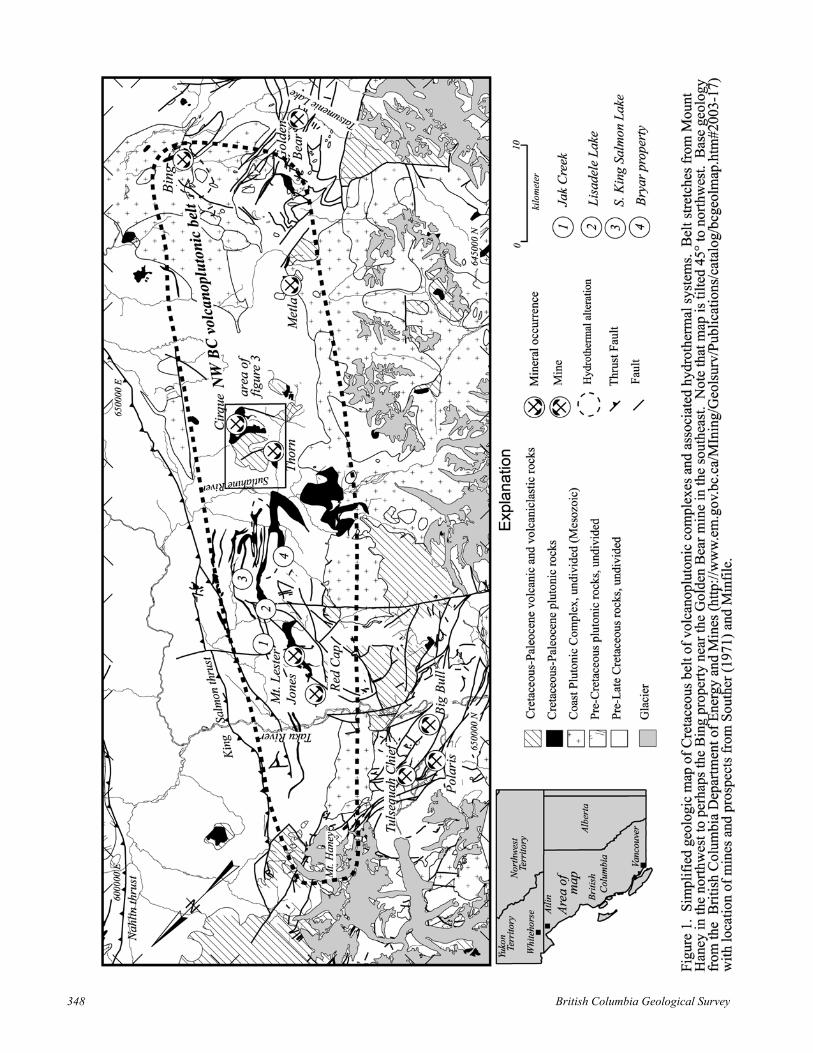
The best-preserved section of these strata is located at the Thorn property. Here, approximately 1800 m of subaerial volcanic and related sedimentary rocks are preserved. The Thorn volcanic sequence is characterized by flat-lying strata, except around the margins, where the contact between older strata and Late Cretaceous volcanic rocks is steeply faulted causing local rotation and tilting of volcanic stratigraphy. This faulted margin is continuous along the eastern contact and forms a curvilinear trace across the geologic map (Fig. 3). In one location, the original stratigraphic contact between the volcanic rocks and older rocks is preserved (Fig. 4). Here, the 93 Ma quartz-feldspar-biotite porphyrytic diorite of the Thorn stock (Mihalynuk, 2003) is overlain by boulder conglomerate composed of rounded clasts of porphyry diorite (see below). The section through the Late Cretaceous volcanic rocks and unit descriptions are outlined below.
93Ma Thorn Stock
Basal Conglomerate
84.7±0.8Ma Weakly welded dacite tuff
Figure 4. Unconformity at the base of Windy Table volcanic rocks: a 1 to 5 m thick basal conglomerate separates 93 Ma Thorn stock (base of photo) from 85 Ma subaerial volcanic rocks (top of photo). Note: Sample 4AS9B (Table 1) was collected from the weakly welded tuff above conglomerate in this photo.
THORN STRATIGRAPHIC SECTION THROUGH WINDY TABLE VOLCANIC ROCKS
The basal contact of the Windy Table volcanic rocks crops out for several tens of meters in Amarillo Creek at the Thorn property (Fig. 4). Here, the basal contact is a monomictic clast-supported, cobble to boulder conglomerate. Clasts are typically rounded and composed of quartz-feldspar-biotite porphyrytic diorite to quartz diorite, likely of Thorn stock affinity. The .
Geological Fieldwork 2004, Paper 2005-1 351

TABLE 1. PRELIMINARY U/PB AND 40AR/39AR GEOCHRONOLOGY OF MAGMATIC AND MINERALIZED ROCKS, PRELIMINARY RESULTS. * BESIDE SAMPLE NUMBERS INDICATE AGES
FROM MIHALYNUK ET AL. (2003); ALL OTHER SAMPLES FROM THIS STUDY. ALL AGES ARE GIVEN WITH ERRORS AT 2Σ. 13 U/PB SAMPLES AND 8 40AR/39AR SAMPLES STILL IN PROGRESS.
Note: Abreviations used above Sensitive High Resolution Ion Micro Probe Reverse Geometry (SHRIMP-RG), Thermal Ionization Mass Spectrometer (TIMS), Biotite (Bt), Hornblende (Hbld), Quartz (Qtz), fine-grained (f.g.)
conglomerate matrix is made up of coarse to fine sand-sized detritus, chiefly composed of coarse sand-sized diorite, rounded quartz, and subrounded feldspar, which has been replaced by sericite.
Above the basal conglomerate is an 80 m succession composed dominantly of dacitic to andesitic lapilli tuffs with lesser flows and volcaniclastic rocks. Individual beds do not extend for more than tens of metres along strike due to rapid lateral facies changes and lack of marker horizons. Tuffs are unwelded to weakly welded. In Amarillo Creek, a 15 to 80 cm lithic poor, weakly welded dacitic crystal tuff directly overlies the basal conglomerate. This tuff has a U/Pb SHRIMP-RG zircon age of 84.7±0.8 Ma (4AS9B, Table 1). This age marks the onset of Windy Table volcanism in the study area.
Stratigraphically above the tuff-dominated strata is a 120 m section of volcaniclastic-dominated strata with lesser tuffs. Individual beds are poorly sorted, can be difficult to distinguish, and are laterally discontinuous. Typically, clasts are volcanic rocks with lesser sedimentary rocks and intrusive rocks. Clasts are
subrounded to rounded, and range in size from boulder to fine sand.
U/Pb
Thorn AreaAS-099a 6491930 629040 Rhyolite flow, fine grained, aphanitic 80.8+3.6/-4.9 U/Pb TIMS (Zircon)AS-035a 6492888 628407 Trachyte flow, feldsparpheric, feldspar phenocrystic 81.1±1.5 U/Pb SHRIMP-RG (Zircon)AS-107a 6493090 631320 Cirque monzonite, feldspar porphyritic 82.2±0.2 U/Pb TIMS (Zircon)MMI02-04-15 * 6496260 630090 Sutlahine Rhyolite Breccia 82.8±0.6 U/Pb TIMS (Zircon)4AS9B 6493530 627160 Weakly welded crystal tuff, feldsparpheric, <1% xenocrystic 84.7±0.8 U/Pb SHRIMP-RG (Zircon)MMI02-01-03 * 6490890 628200 Thorn Stock; Bt-Hbld-Qtz-feldspar porphyritic diorite-qtz diorite 93.3±2.4 U/Pb TIMS (Zircon)AS-071a 6490270 632543 Fine grained aphanitic rhyodacite dyke 168.1±0.7 U/Pb TIMS (Zircon)
Mt Lester Jones Area4AS11 0.8 U/Pb SHRIMP-RG (Zircon)MMI94-45 0.2 U/Pb TIMS (Zircon)MMI94 0.9 U/Pb TIMS (Zircon)
Ar-Ar (Cooling)
Thorn AreaAS-017b 1.8 40Ar/39Ar (Muscovite)AS-068e 3.6 40Ar/39Ar (Biotite)
Ar-Ar (A
Thorn AreaAS-025a 1.4 40Ar/39Ar (Sericite)Outlaw 0.5 40Ar/39Ar (Biotite)THN03-22 0.6 40Ar/39Ar (Sericite)277540 0.9 40Ar/39Ar (Sericite)91AP2-1 1.0
6506538 612037 Bt-Hbld-feldspar porphyritic diorite 55.3±-6 * 6510100 605100 Mt. Lester Jones Porphyry 83.8±
-9-4 * 6513150 698800 Red Cap Porphyry 87.3±
6493800 628290 Trachyandesite sill, intruding Windy Table volcanic rocks 83.1±6492585 633215 Equigranular monzonite bearing biotite and hornblende 90.7±
lteration)
6491624 627740 In vein sericite from B-zone qtz-enargite-tetrahedrite-pyrite vein 79.3±6490280 627650 Sericite adjacent to arsenopyrite from AS-071a 84.8±6491914 628769 In vein sericite from Oban Breccia-Thorn Property 87.7±6491150 628070 Sericite from "unaltered" Thorn Stock 91.0±
4A * 6491640 627650 f.g. sericite/illite from Thorn Stock 91.0± 40Ar/39Ar (Sericite)
Interpreted Age (Ma) Method (Mineral)Sample Northing Easting Description
A 360 m-section dominated by dacitic lapilli tuff overlies the volcaniclatic rocks. This section is similar to the lowermost sequence of tuffs. Approximately 15 m above the volcaniclastic sequence is a 5 m thick feldspar phenocrystic trachyte flow which returned an U-Pb zircon age of 81.1±1.5 Ma (AS-035a, Table 1).
Stratigraphically above the tuff and volcaniclastic rock dominated sequence is a 340 m thick section of flows, domes and intrusive rocks. At the headwaters of Amarillo Creek is a series of vertical dikes, which are inferred to be feeders to the extrusive lavas, as well as domes. Here, the domes and dikes are flow foliated. Foliation is generally flat lying, but is locally intensely folded (syn-magmatic) and steeply dipping in the feeder dikes. Overall, the lava-dominated section is characterized by fine-grained, dacitic feldspar phyric units at the base that upsection become coarser grained quartz-feldspar phenocrystic rhyolite flows. Minor tuffs and volcaniclastic rocks are intercalated with the lavas. A 40Ar-39Ar age on coarse muscovite of 83.1±1.8 Ma
352 British Columbia Geological Survey
(AS-017b, Table1) was obtained from a trachyandesite sill intruding the strata about 215 m up from the base of this sequance.
Poorly outcropping volcanic and volcaniclastic strata compose another 900 m that extends to the current top of the volcanic sequence. Close to the top of the volcanic sequence, Mihalynuk (2003) reported a U-Pb (zircon) age of 82.8±0.6 Ma (MMI02-04-15, Table 1) for a rhyolite breccia.
The available geochronology from the Windy Table volcanic rocks implies that some 1600 m of volcanic and volcaniclastic rocks may have been deposited within as much as 3 to 4 million years. However, it is also important to point out that the time range could be significantly less as the uncertainties on the ages overlap throughout the sequence suggesting that there could have been very rapid deposition of most of the volcanic sequence. Implicit in the thickness and similar aged volcanic facies is that the volcanic section at the Thorn is a remanent of a volcanic centre.
Intrusive Rocks
Three main periods of plutonism have been recognized in the study area. The oldest is represented by minor ca.168 Ma intrusive rocks. The major period for the purposes of this study is represented by 92 to 81 Ma Late Cretaceous subvolcanic intrusive rocks. The youngest event consists of Early Tertiary magmatism related to the Sloko volcanism. The younger period of plutonism is rare in the study area and has only been recorded at one location north of Lisadele Lake (Fig. 1), but it is also reported near the Golden Bear mine (Brown and Hamilton, 2000).
PRE-LATE CRETACEOUS INTRUSIVE ROCKS
A 168.1±0.7 Ma (AS-071a, Table 1) intrusion has been recognized in one location at the Thorn property. This intrusion is a 3 to 5 m wide, fine-grained, aphanitic rhyodacite dike intruding into Stuhini Group sedimentary rocks at the Outlaw prospect (Fig. 3). Previously, it has been informally suggested that these dikes may have been the source of the mineralizing fluids at the Outlaw. However, hydrothermal biotite from the same rock (Outlaw, Table 1) yield minimum ages of 84.8±0.5 Ma (includes 84.3% of the 39Ar with an inverse isochron age of 85.4±1.3 Ma and initial 40Ar/36Ar of 279±28). This suggests that the dikes and their margins simply focused younger hydrothermal fluids.
Jurassic plutons are common in the Coast batholith where they in part form the Fourth of July Plutonic Suite of Mihalynuk (1999). They are not known within the study area. The 168.1±0.7 Ma age of intrusive rock at the Outlaw is, furthermore, not a common age for
Jurassic magmatism regionally. However, some cooling ages from Fourth of July Plutonic Suite are as young as 165 Ma (M. Mihalynuk, pers comm, 2004), which suggests the potential for plutonic rocks of similar age lying to the west of the study area.
LATE-CRETACEOUS INTRUSIVE ROCKS
Late Cretaceous subvolcanic plutons are widespread throughout the study area (Fig. 1). Known intrusive rocks of this age extend from as far north as Mt. Lester Jones to as far south as the Thorn property. Rocks of similar composition and texture were mapped and collected for geochronology between the Golden Bear mine and the Thorn property in an attempt to extend the volcanoplutonic belt. These southern rocks are as yet undated, and thus their precise relationship to the northern rocks is unknown.
The best understood portion of the belt is at the Thorn property where two pulses of magmatic activity are evident. The older of the two is represented by the quartz-feldspar-biotite porphyrytic diorite and quartz diorite of the Thorn stock. This stock is unconformably overlain by ca. 85 to 82 Ma Windy Table volcanic rocks and intruded by similar-age Windy Table Plutonic Suite rocks.
93 Ma Intrusive Rocks
Plutonic rock of known 93 Ma age are regionally rare. Known examples of this are at the Thorn property (Mihalynuk, 2003), Jack Peak and Racine Lake (Mihalynuk, 1999). During the 2004 field season several small Thorn stock-like intusive rocks were mapped and sampled between Golden Bear mine and Tulsequah mine. However, assigning plutonic rocks to particular periods of magmatic activity is difficult as similar lithologies are known to intrude as part of the Tertiary Sloko magmatic epoch (Mihalynuk, 1999). In the study area, only one age has been reported in this time period. Mihalynuk (2003) reports a U/Pb zircon age of 93.3±2.4 Ma for the Thorn stock. The Thorn stock is the largest known example and covers a 3.5 by 1.5 km area.
The 93 Ma intrusions are best illustrated by the Thorn stock. The stock is a quartz-feldspar-biotite porphyrytic diorite to quartz diotire. Marginal phases are fine-grained feldspar phyric and flow-banded. Hydrous phases are biotite and lesser horneblende. Common accessory minerals include magnetite and apatite. These rocks are pervasively chlorite and sericite altered.
Windy Table Suite
Windy Table plutonic rocks are common in the map area (Fig. 2). Three different compositional types of intrusions are mapped. The most common is a biotite-bearing, porphyrytic monzonite that contains
Geological Fieldwork 2004, Paper 2005-1 353

conspicuous feldspar phenocrysts. These rocks have associated hydrothermal systems through the region. Examples include the 83.8±0.2 Ma (MMI94-45-6, Table 1) Mt. Lester Jones porphyry (Mihalynuk, 2003), the 87.3±0.9 Ma (MMI94-9-4) Red Cap porphyry (Mihalynuk, 2003) and the 82.2±0.2 Ma (AS-107a, Table 1) Cirque monzonite (Simmons et al., 2003). A second type of intrusion is a biotite-hornblende–bearing, medium-grained, equigranular, monzonite to granodiorite. None of this compositional type have yet been dated, however, in the Cirque at the Thorn property these intrusions intrude the Cirque monzonite, and are thus presumably of Late Cretaceous age. Other examples of this intrusive suite were mapped in the Bryar area and Lisadele Lake area (Fig. 1).
The least prevalent intrusive suite are fine-grained, aphanitic trachytic dikes, which crop out on the Thorn property. These rocks could represent subvolcanic equivalents or feeders to the trachytic flows in the Windy Table volcanic rocks.
55 MA POST-CRETACEOUS INTRUSIVE ROCKS
Souther (1971) mapped abundant early Tertiary Sloko plutonic rocks in the study. Between this study and Mihalynuk (2003), only one location is known where unequivocal Sloko plutonic rocks crop out. A feldspar-biotite porphyrytic diorite was mapped in the Lisadele Lake area, where it intrudes into Laberge Group clastic sedimentary rocks. This rock returned a U/Pb zircon age of 55.3±0.8 Ma (4AS11, Table 1). The petrologic similarity of this rock and the Thorn stock make it very difficult to unequivocally distinguish the two rock suites.
GEOCHEMICAL STUDIES - PRELIMINARY RESULTS
Geochemical studies of magmatic rocks along the belt have concentrated around the Thorn property where the geochronologic framework permits placing the compositional groups into distinct time packages. The goals of this study are to geochemically characterize the different rocks units, place constraints on the paleotectonic environment and note any changes in chemistry as the magmatic arc evolved through time. Major, trace and rare earth element data are available from 23 representative samples of all intrusive rocks and Late Cretaceous subaerial volcanic rocks in the Thorn property area. An additional 18 regional samples are in preparation or have not yet been analyzed. Preliminary interpretations are plotted in Figure 5. It is important to note that the rocks from the Thorn property were sampled in proximity to mineralized hydrothermal systems and thus have been altered to varying degrees, thus limiting the usefulness of the major elements to
characterize geochemical composition or tectonic environment in which these rocks were emplaced.
Middle Jurassic intrusive rocks are geochemically distinct from the Cretaceous intrusive and extrusive rocks. In general, the Jurassic intrusions have within plate affinity and tend to be more mafic and alkaline than younger intrusions (Fig. 5A,C-D). These intrusions are characterized by a relative enrichment compared to chondrite in light rare earth (LREE) and heavy rare earth elements (HREE), a shallow rare earth pattern decreasing toward the HREE and a sharp negative Eu anomaly (Fig. 5E). Unfractionated HREE patterns, such as those exhibited by Middle Jurassic intrusions, suggest that there was no garnet or hornblende in the residuum and likely represent a deep magma signature.
The 93 Ma intrusive rocks are not obviously geochemically distinct from other Late Cretaceous intrusive rocks. However, the 93 Ma rocks tend to have lower SiO2 contents than other intrusive rocks. They also have a slight tholeiitic affinity compared to other intrusive rocks (Fig. 5B). The REE pattern exhibits unfractionated HREE and a minor negative Eu anomaly (Fig. 5F). The HREE pattern can be explained by either increased pressure at the melt generation site, leaving garnet as the stable phase in the residuum (e.g., Kay and Abruzzi, 1996; Bissig et al., 2003) or by an increased amount of water in the magma leading to hornblende fractionation and HREE depleted melts (e.g., Haschke et al., 2001; Bissig et al., 2003). The small Eu depletion can be explained by oxidized conditions in the magma or a plagioclase-free residuum.
Windy Table Suite intrusive rocks exhibit much the same chemistry as 93 Ma intrusive rocks, with only minor chemical differences. For example, Windy Table intrusive rocks tend to have a compositional range from andesite to trachyte whereas the 93 Ma intrusive rocks are mainly dacite to andesite (Fig. 5A). The Windy Table intrusive rocks also have a slightly more calc-alkaline affinity (Fig. 5B). Most samples exhibit unfractionated HREE and a minor negative Eu anomaly, similar to 93 Ma intrusions (Fig. 5F). Two samples display an overall depletion of REE and an increased negative Eu anomaly. These samples are trachyte dikes, which tend to be more altered (sericite-silica-pyrite) which could explain the abnormal chemistry. Alternatively these dikes may also be ca. 55 Ma Sloko intrusive rocks.
Windy Table volcanic rocks have a wide array of compositions ranging from trachyte to andesite. On the Rb vs Y+Nb plot (Fig. 5D), three samples have a within plate affinity. These samples are lithic-bearing pyroclastic rocks, and the anomalous chemistry may reflect the influence on the bulk geochemical composition of lithic fragments. In general, the REE signature is similar to that of their intrusive equivalents, with the exception of a slightly wider spread in HREE concentration (Fig. 5E). The wider spread and abnormal
354 British Columbia Geological Survey

Figure 5. Geochemical discriminant and chondrite-normalized REE abundance diagrams for volcanic and subvolcanic intrusive rocks from the Thorn property and surrounding area. Closed squares represent Jurassic intrusive rocks, open squares represent Windy Table Suite felsic tuffaceous and flow rocks, closed triangles represent Windy Table Suite subvolcanic intrusive rocks and open triangles represent ca. 93 Ma Thorn stock and Thorn stock-like diorite-quartz diorite intrusions.
Geological Fieldwork 2004, Paper 2005-1 355

samples may be explained by the lithic fragment chemistry.
Magmatic rocks that fall within the Late Cretaceous time constraint generally have similar compositions. These similarities make it difficult to distinguish fundamental chemical characteristics between the ~93 Ma and ~83 Ma pulses of magmatism. More work is required on determining differences in REE and immobile element ratios between these rocks.
CHARACTERISTICS OF MAGMATIC-HYDROTHERMAL ALTERATION SPATIALLY AND TEMPORALLY ASSOCIATED WITH LATE CRETACEOUS MAGMATIC ROCKS
Magmatic-related hydrothermal alteration and sulfide-bearing rocks are common throughout the study area. Six styles of mineralization are associated with the Late Cretaceous volcanoplutonic belt: 1) quartz-pyrite-enargite-tetrahedrite veins, 2) breccia-hosted Ag-Pb-Zn-(Au-Cu)–bearing sulfides, 3) porphyry Cu-Mo, 4) quartz-arsenopyrite±sphalerite-galena veins and disseminations, 5) skarn and carbonate replacement and, 6) sedimentary rock-hosted or Carlin-like mineralization.
Quartz-pyrite-enargite veins are known only at the Thorn property. There, the veins are hosted in syn-mineralizing normal faults (Lewis, 2002) only within the 93 Ma Thorn stock. Sulphide minerals include pyrite, enargite, tetrahedrite/tennantite, with lesser sphalerite, galena, cassiterite and rare native gold and argentite. Veins are typically enveloped by a narrow 50 cm to 3 m zone of pyrophyllite-sericite-dickite alteration in a wider zone (5-100 m) of intense sericite-clay-pyrite (±dickite) alteration. These zones are flanked by weak clay-sericite-chlorite alteration grading out into chlorite with lesser sericite altered country rock. Pyrophyllite-dickite alteration and tin-bearing minerals (e.g., cassiterite) suggest that the mineralizing system is hot and may have formed in the transition zone between deeper porphyry environment and the shallower epithermal environment.
The retriction of the veins to the Thorn stock suggests a genetic link between the veins and the host rocks. Support for this conclusion was provided by Mihalynuk (2003) who reported a 40Ar/39Ar age on sericite from intensely altered Thorn stock of 91.0±1.0 Ma. However, attempts to confirm this age have resulted in conflicting data. As part of this study, a 40Ar/39Ar age on sericite (AS-025a, Table 1) enclosed in enargite from a different location on the Thorn property resulted in a minimum age of 79.3±1.4 Ma (includes 84.4% of the 39Ar with an inverse isochron age of 79.7±2.3 Ma and initial 40Ar/36Ar of 292±15). It is unclear at this time what the age discrepancy means.
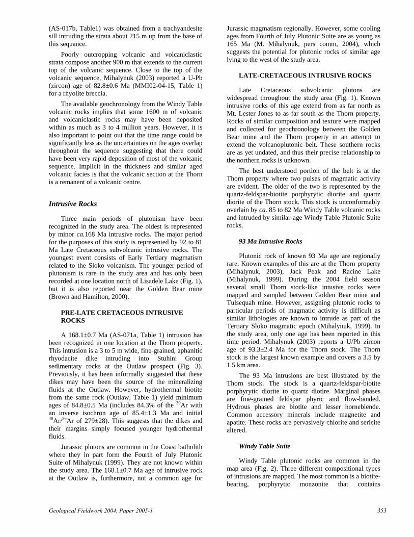
Breccia-hosted Ag-Pb-Zn-(Au-Cu) mineralization occurs at the Metla and Thorn properties, and presumably at other unknown locations as several unmineralized breccia pipes were mapped in the Lisadele Lake area during the 2004 field season. The breccia-hosted prospects are characterized by clast-supported, rounded pebble to boulder breccia, where the ore minerals have replaced a fine-grained rock(?) matrix (Fig. 6). Sulphide minerals include pyrite, sphalerite and boulangerite with lesser chalcopyrite. At the Thorn property, sulphosalt is a dominant phase, whereas at the Metla there are only trace amounts of sulphosalt and chalcopyrite. At the Thorn, sericite occurs as narrow massive zones replacing the matrix of the breccia, this narrow sericite-dominated alteration is flanked by moderate sericite-clay-pyrite alteration grading to weak sericite-chlorite alteration. Sericite (THN03-22, Table 1) from the mineralized matrix, enclosed in pyrite-sphalerite-boulangerite mineralization from the Thorn property yields an age of 87.7±0.6 Ma (includes 81.8% of the 39Ar with an inverse isochron age of 87.6.7±4.3 Ma and initial 40Ar/36Ar of 297±70), suggesting that it may be associated with a hydrothermal system produced by the 93 Ma suite of intrusions.
Mineralized Matrixof Breccia
Figure 6. Pyrite-sulphosalt mineralization replacing matrix of magmatic hydrothermal breccia at the Thorn property.
Porphyry Cu-Mo deposits are the most widespread
hydrothermal mineralizing type in the study area. Feldspar porphyrytic monzonite is the most common host rock for porphyry Cu-Mo mineralization in the belt. Mineralization is characterized by thin (1 mm-8 cm) structurally controlled vein sets. Ore mineralization occurs as both disseminations in the host rock and in the vein sets. Vein mineralogy includes quartz-pyrite-chalcopyrite-molybdenite with lesser feldspar and rare sulphosalt. Where veining is most intense biotite-clay alteration dominates and is flanked by a broader zone of chlorite alteration. U/Pb geochronology (zircon) at the Thorn property on the Cirque monzonite gives an age maximum for porphyry Cu-Mo mineralization of 82.2±0.2 Ma (AS-107a, Table 1).
356 British Columbia Geological Survey

Like the porphyry Cu-Mo mineralization, quartz-arsenopyrite veins and disseminations are also widespread. These veins were encountered from the Outlaw showing (Fig. 3) to the Red Cap showing, west of Mt. Lester Jones (Fig. 1). At the Red Cap, thin, massive vein swarms are hosted in shears along the contact between porphyrytic dikes and altered Stuhini Group volcanic and sedimentary rocks. Typical vein mineralogy includes pyrite, arsenopyrite, galena, and sphalerite with lesser chalcopyrite and molybdenite in a quartz-carbonate matrix. During the 2004 field season previously unknown zones with this style of mineralization were mapped in the Jak, South King Salmon Lake and Bryar areas. Alteration is characterized by narrow zones, (tens of metres thick) of pervasive silica-sericite-clay (±biotite) alteration, which grades outwards into chlorite-clay alteration. At the Outlaw showing on the Thorn property, hydrothermal biotite (Outlaw, Table 1) adjacent to arsenopyrite was dated at 84.8±0.5 Ma (includes 84.3% of the 39Ar with an inverse isochron age of 85.4±1.3 Ma and initial 40Ar/36Ar of 279±28).
Skarn and carbonate replacement mineralization is common throughout the study area; however, limestone beds in the region are only thin (maximum of approximately 10 m) limiting the potential for skarn deposits. Examples can be found at the Bungee showing on the Thorn property, in the Bryar area and South King Salmon Lake area (Fig. 1). Discontinuous lenses, 2 to 8 m thick, of massive and semi-massive pyrhhotite-sphalerite with lesser galena and rare chalcopyrite characterize these occurrences. Typical skarn-related calc-silicate minerals including diopside and garnet increase in abundance towards the mineralized zone. The lack of precious metals and small size makes these less attractive exploration targets.
Oliver (1996) suggests that Golden Bear mineralization is similar to Carlin-type Au like those on the Carlin trend (see also Brown and Hamilton, 2000). There are no plutons in the immediate area of Golden Bear mine, however, a 40Ar/39Ar age was produced from hydrothermal sericite of 83.9±1.2 Ma (Oliver, 1996) suggesting that the mineralizing fluids at Golden Bear may be derived from rocks of the Late Cretaceous volcanoplutonic belt.
DISCUSSION AND PRELIMINARY CONCLUSIONS
Although still in its infancy, preliminary results from this project give new insights into the nature, timing and distribution of magmatic rocks in the area south of the Taku river, northern Stikinia and their timing relationship to hydrothermal mineralization in the region. Mapping in the 2004 field season extended
the Late Cretaceous volcanoplutonic belt identified by Mihalynuk (2003) and Simmons (2003) north and south of its previously known limits. Furthermore, the Late Cretaceous belt may be divided into two distinct pulses of magmatic activity: a 94 to 87 Ma pulse of largely diorite porphyries and an 85 to 80 Ma pulse of sub-aerial volcanic rocks and co-magmatic subvolcanic intrusive rocks. It is not well understood which of these pulses of magmatism have more prospective hydrothermal systems associated with them. However, preliminary ages, as part of this study, from known magmatic-hydrothermal alteration along the belt suggests that the Late Cretaceous subvolcanic intrusions have associated hydrothermal systems spanning at least 91 to 79 Ma.
An important step in exploring for magmatic-hydrothermal deposits is to understand the timing and spatial relationships between hyrdothermally altered rocks and the magmatic host and source rocks. At the Thorn property, 40Ar/39Ar ages on sericite from enargite veins suggest that hydrothermal alteration associated with these veins may be linked to younger Windy Table (85-81 Ma) magmatism. However, Mihalynuk (2003) suggests that sericite alteration associated with enargite veins is 91 Ma and may be associated with the older magmatic pulse. The discrepancy in ages is not understood at this time. Also at the Thorn property, sericite from breccia-hosted Ag-Pb-Zn-(Au-Cu) mineralization suggest that hydrothermal alteration may be linked to the 94 to 87 Ma magmatic pulse. At the Cirque showing on the Thorn property the timing of porphyry Cu-Mo mineralization is constrained to a minimum by the host ca. 82 Ma monzonite. A Pb isotope study is underway to help determine which magmatic pulse is most likely to be the source of fluids for mineralized veins.
Enargite veins have been a recent focus for exploration along the belt. Pyrophyllite alteration related to enargite veins at the Thorn property suggest that these veins formed in a hot and deep(?) environment, possibly at the porphyry-epithermal transitional depth beneath the leached cap. Fluid inclusion work is currently underway to constrain depth and temperature of ore mineral deposition in these veins. Historically, Late Cretaceous volcanic strata in the study area have been sporadically explored. Geochronology at the Thorn property suggest that Windy Table volcanic rocks overlap in time with alteration associated with Au-Ag-Cu–bearing enargite veins, leaving the possibility that the volcanic strata may host epithermal deposits topographically above the porphyry-epithermal transitional depths. Mapping during the 2004 field season identified similar volcanic stratigraphy north of the Thorn property indicating that more chronologically favourable strata may be found along the Late Cretaceous volcanoplutonic belt.
Geological Fieldwork 2004, Paper 2005-1 357

ACKNOWLEDGMENTS
Norm Graham of Discovery Helicopters provided excellent and timely helicopter service during the summer without whose help this project would not have progressed as planned. Tom Bond of Lakelse Air also provided excellent helicopter service. We thank Helen Smith for making life operate as normal while in the field. Jim Mortensen for valuable input geochronology and tectonics of magmatic rocks in the Cordillera. Mitch Mihalynuk has provided valuable information about the stratigraphy and geology of the northern Stikine Terrane, discussions about the timing of magmatic activity and hydrothermal alteration have been extremely valuable. Rimfire Minerals Corp. and Equity Engineering Ltd. provided logistical support for much of this project. We thank Dave Tupper of Solomon Resources Ltd. for allowing sampling on the Metla property. We also thank Shane Ebert who provided excellent insights about porphyry-epithermal mineralization and alteration in the field. Gayle McCreery, Brett McKay and Tim Sullivan provided outstanding company in the field. MDRU contribution P-180.
REFERENCESBaker, D.E.L. (2004): 2003 Geological, geochemical and
diamond drilling report on the Thorn property; British Columbia Ministry of Energy and Mines, Assessment Report #27, 379 pages.
Barker, F., Arth, J.G. and Stern, T.W. (1986): Evolution of the Coast batholith along the Skagway traverse, Alaska and British Columbia; American Mineralogist, Volume 71, pages 632-643.
Bissig, T., Clark, A.H., Lee, J.K.W. and von Quadt, A. (2003): Petrogenetic and metallogenic responses to miocene slab flattening: new constraints from El Indio-Pascua Au-Ag-Cu belt, Chile/Argentina; Mineralium Deposita, Volume 38, pages 844-862.
Brew, D.A. and Morrell, R.P. (1983): Intrusive rocks and plutonic belts of southeastern Alaska; Geological Society of America, Memoir 159, pages 171-193.
Bultman, T.R. (1979): Geology and tectonic history of the Whitehorse Trough west of Atlin; unpublished PhD thesis, Yale University, 284 pages.
Brown, D. and Hamilton, A. (2000): The Golden Bear mine: Carlin-type sediment-hosted, dissememinated gold deposit in northwestern British Columbia, in Geology and Ore Deposits 2000: The Great Basin and Beyond, Cluer, J.K., Price, J.G., Struhsacker, E.M., Hardyman, R.F., and Morris, C.L., editors, Geological Society of Nevada Symposium Proceeds, May 15-18, 2000, pages 1002-1020.
Hart, C.J.R., Pelletier, K.S., Hunt, J. and Fingland, M. (1989): Geological map of Carcross (105D/2) and part of Robinson (105D/7) map areas; Indian and Northern Affairs Canada, Open File Map 1989-1.
Hart, C.J.R. and Radloff, J.K. (1990): Geology of the Whitehorse, Alligator Lake, Fenwick Creek, Carcross
and part of the Robinson map areas (105D/11, 6, 3, 2 & 7), Yukon Territory; Indian and Northern Affiars Canada, Open File 1990-4, 113 pages and 4 map sheets.
Haschke, M., Günther, A., Siebel, W., Scheuber, E. and Reutter, K-J. (2001): Magma source variations of late Cretaceous-late Eocene magmatic rocks of the Chilean Precordillera (21.5-26ºS): due to vaiable water fugasity or crustal thickening? poster on http://sfb267.goeinf.fu-berlin.de/web/de/poster/posterb.asp
Kay, S.M. and Abbruzzi, J.M. (1996): Magmatic evidence for for Neogene lithospheric evolution of the Central Andean “flat slab” between 30 and 32ºS; Tectonophysics, Volume 259, pages 15-28.
Kerr, F.A. (1948): Taku River map area, British Columbia; Geological Survey of Canada, Memoir 248.
Lewis, P. (2002): Structural analysis of Au-Ag-Cu mineralization in the Camp Creek area, Thorn property; private report for Rimfire Minerals Corporation and First Au Strategies Corp., dated July 15, 2002. In H.J. Awmack (2003): 2002 Geological, Geochemical and Diamond Drilling Report on the Thorn Property, B.C. Ministry of Energy and Mines, Assessment Report #27, 120 pages.
Mihalynuk, M.G., Meldrum, D., Sears, W.A. and Johannson, G.G. (1995a): Geology of the Stuhini Creek Area (104K/11); in Geological Fieldwork 1994, Grant, B. and Newell, J.M., editors, B.C. Ministry of Energy Mines and Petroleum Resources, Paper 1995-1, pages 321-342.
Mihalynuk, M.G., Meldrum, D., Sears, W.A. and Johannson, G.G., Madu, B.E., Vance, S., Tipper, H.W. and Monger, J.W.H. (1995b): Geology and Lithogeochemistry of the Stuhini Creek Area (104K/11), B.C. Ministry of Energy Mines and Petroleum Resources, Open File 1995-5.
Mihalynuk, M.G. (1999): Geology and Mineral Resources of the Tagish Lake Area, BC; Ministry of Energy and Mines, Bulletin 105.
Mihalynuk, M.G., Mortensen, J., Friedman, R., Panteleyev, A. and Awmack, H.J. (2003): Cangold partnership: regional geologic setting and geochronology of high sulphidation mineralization at the Thorn property. British Columbia; Ministry of Energy and Mines, Geofile 2003-10.
Oliver, J.L. (1996): Geology of Stikine assemblage rocks in the Bearskin (Muddy) and Tatsamenie Lake District, 104K/1 and 104K/8, northwestern British Columbia, Canada and characteristics of gold mineralization, Golden Bear mine: northwestern British Columbia; unpublished PhD thesis, Queen’s University, 242 pages.
Sawkins, F.J. (1990): Metal deposits in relation to plate tectonics, 2nd edn.: Springer-Verlag, Berlin, 461 pages.
Sillitoe, R.H. (1972): Relation of metal provinces in western Americas to subduction of oceanic lithosphere; Geological Society of America, Bulletin, Volume 83, pages 813–818.
Simmons, A., Tosdal, R., Baker, D. and Baknes, M. (2003): Geologic framework of the Thorn epithermal deposit, northwestern, BC; British Columbia and Yukon Chamber of Mines, poster abstract for the Mineral Exploration Roundup.
358 British Columbia Geological Survey
Souther, J.G. (1971): Geology and mineral deposits of the Tulsequah map-area, British Columbia; Geological Survey of Canada, Memoir 362, 84 pages.
Sutherland-Brown, A., Editor (1976): Porphyry deposits of the Canadian Cordillera; Canadian Institute of Mining and Metallurgy, Special Volume 15, 510 pages.
Titley, S.R., Editor (1982): Advances in geology of the porphyry copper deposits, southwestern North
America, Tucson, University of Arizona Press, 560 pages.
Wheeler, J.O. (1961): Whitehorse map-area, Yukon Territory, (105D); Geological Survey of Canada, Memoir 312, 156 pages.
Wheeler, J.O., Brookfield, A.J., Gabrielse, H., Monger, J.W.H., Tipper, H.W. and Woodsworth, G.J. (1991): Terrane map of the Canadian Cordillera; Geological Survey of Canada, Map 1713A, scale 1:2 000 000.
Geological Fieldwork 2004, Paper 2005-1 359

360 British Columbia Geological Survey