Embed Size (px)
Citation preview
1 INTRODUCTION
“Palsa-scale frost mound” is a generic term used todescribe a variety of morphologically similar aggrada-tional features developed within the active layer abovepermafrost. Although several formative processes havebeen identified, the positive relief of all frost mounds is ascribable to accumulation of ice in the substrate(Nelson et al. 1992, Gurney 2001).
The periglacial literature contains a great deal ofcontroversy about the term palsa. At its root lies disagreement about whether classification schemesshould be based on morphology, genesis, constituentmaterials, or combinations of these parameters. In thispaper we follow conventions established by Washburn(1983a, b) and Nelson et al. (1992), using “palsa” in astrictly morphological sense with reference to medium-scale frost mounds, independent of genesis, constituentmaterial, or location in the hierarchy of permafrostcontinuity.
Terminological issues aside, palsa-scale frostmounds can be important sources of paleoenvironmen-tal information (e.g., Vorren 1972, Vorren & Vorren1975, Lavoie & Payette 1995). Once a palsa is formed,its microclimate changes and new plant associations,very different than those of surrounding low areas,occupy palsa summits (Sjörs 1961, Railton & Sparling1973, Seppälä 1990). Vegetation differences atop andaround frost mounds can play a useful role in applying14C techniques to date the inception of mound growth.Vorren (1972, 1979a, 1979b) and Vorren & Vorren(1975) first demonstrated that radiocarbon dating, in
combination with pollen analysis, could be used to esti-mate timing of the onset of frost mound growth.
This paper reports results of a palsa coring pro-gram. Patterns of pollen, soil organic carbon, and soiltexture from a core collected from a palsa summit areanalysed. The palsa is located in an area that has under-gone significant landscape evolution, with consequentimpact on local hydrology and vegetation. These localpatterns are superimposed on a long-term signal reflect-ing regional climate and vegetation changes in the lateQuaternary. Our primary goal is to use pollen and soilanalysis to test the feasibility of separating the signalsand reconstruct local landscape processes.
2 SITE DESCRIPTION AND FIELD METHODS
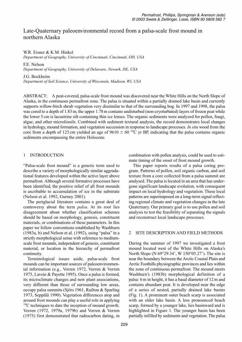
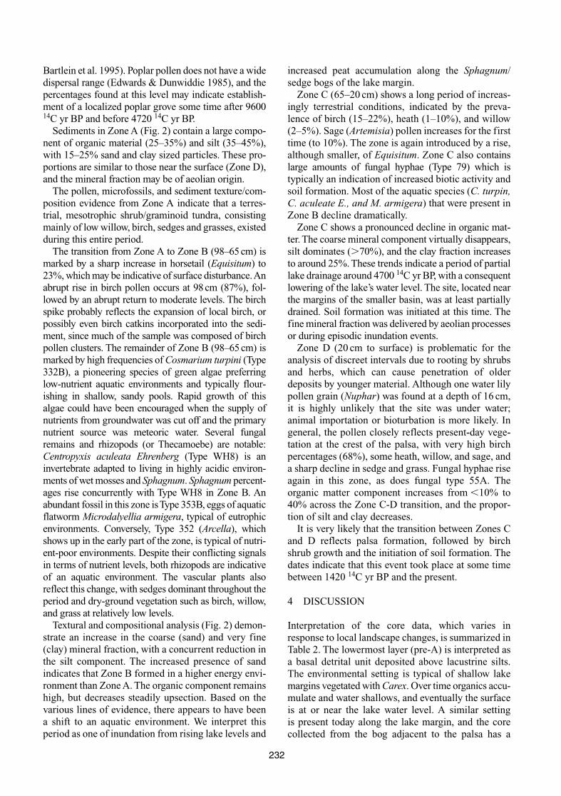
During the summer of 1997 we investigated a frostmound located west of the White Hills on Alaska’sNorth Slope (N 69°29.34�, W 150°05.27�). The site isnear the boundary between the Arctic Coastal Plain andArctic Foothills physiographic provinces and lies withinthe zone of continuous permafrost. The mound meetsWashburn’s (1983b) morphological definition of apalsa: 6 m in height, it has a basal diameter of 12 m andcontains abundant peat. It is developed near the edgeof a series of nested, partially drained lake basins(Fig. 1). A prominent outer beach scarp is associatedwith an older lake basin. A less pronounced beachscarp, formed by a younger lake, lies basinward and ishighlighted in Figure 1. The younger basin has beenpartially infilled by sediments and vegetation. The palsa
229
Late-Quaternary paleoenvironmental record from a palsa-scale frost mound in northern Alaska
W.R. Eisner & K.M. HinkelDepartment of Geography, University of Cincinnati, Cincinnati, OH, USA
F.E. NelsonDepartment of Geography, University of Delaware, Newark, DE, USA
J.G. BockheimDepartment of Soil Science, University of Wisconsin, Madison, WI, USA
ABSTRACT: A peat-covered, palsa-scale frost mound was discovered near the White Hills on the North Slope ofAlaska, in the continuous permafrost zone. The palsa is situated within a partially drained lake basin and currentlysupports willow-birch shrub vegetation very dissimilar to that of the surrounding bog. In 1997 and 1998, the palsawas cored to a depth of 1.83 m; the upper 1.78 m contains undisturbed (non-cryoturbated) layers of frozen peat whilethe lower 5 cm is lacustrine silt containing thin ice lenses. The organic sediments were analyzed for pollen, fungi,algae, and other microfossils. Combined with sediment textural analysis, the record demonstrates local changesin hydrology, mound formation, and vegetation succession in response to landscape processes. In situ wood from thecore from a depth of 123 cm yielded an age of 9610 � 60 14C yr BP, indicating that the palsa contains organic sediments encompassing the entire Holocene.
Permafrost, Phillips, Springman & Arenson (eds)© 2003 Swets & Zeitlinger, Lisse, ISBN 90 5809 582 7
is located near the outlet of the remnant lake, where itdrains into an adjacent basin through a narrow strait.
The climate of the site is cold and semi-continental,with estimated mean annual temperature of �10.7°Cand annual monthly range of 41.4°C (Willmott &Matsuura 2001). Although the thickness of the per-mafrost is unknown, it is estimated to exceed 300 mbased on an assumed geothermal gradient of 3°C/100 m. Average snowcover depth has not been meas-ured, but snowdrifts on the palsa’s flanks are likely tobe substantial. Vegetation atop the palsa and flankingslopes is a shrub assemblage consisting of Betulanana (dwarf birch), Salix glauca (willow), and Ericad(heath), with some mosses and grasses. Thaw depth,measured in mid-August in two years, averaged 45 cm.By contrast, vegetation in the bog surrounding thepalsa is dominated by Carex aquatilis (sedge), and thethaw depth averaged 28 cm.
A sediment core was obtained from the bog sur-rounding the palsa, at a distance of 15 m from it, usinga 7.62 cm (3 inch) diameter coring barrel designed byUSA CRREL, driven by a Little Beaver© power auger.A second core, 128 cm in length, was obtained from aposition atop the palsa. Peat was present throughoutthe core, indicating that we had not penetrated into themassive ice core. Although equipment limitations pre-vented drilling deeper in the palsa in 1997, we returnedto the site the following year and exactly re-occupiedthe borehole. We used extension rods and core extrac-tors to penetrate an additional 54 cm, to a total depthof 182 cm. The palsa core can therefore be consideredcontinuous. The extended section of the core showedthat peat continues downward another 50 cm, and isderived from aquatic plants. The peat is underlain byice-rich lacustrine silts typical of thaw lake bottomsediments. Thin (3 mm) ice lenses grade into massivesegregation ice in the palsa core.
Cores were sampled at 10–15 cm intervals for soilbulk density and texture, pollen, and microfossil con-tent. The organic carbon content was discontinuouslysampled in the upper 40 cm, but regularly sampled at a5-cm interval from 40 to 130 cm depth. Oven-dried soils(dried at 65°C for 48 hr) were passed through a 2-mm
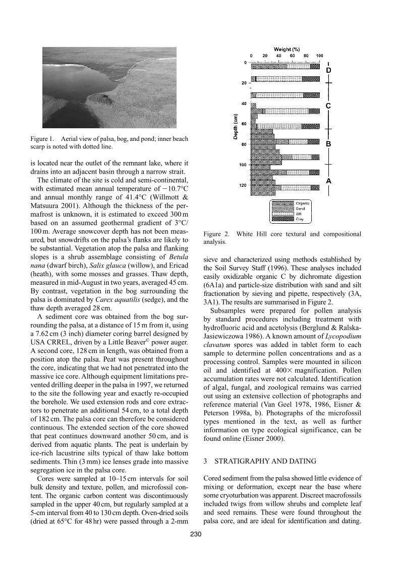
sieve and characterized using methods established bythe Soil Survey Staff (1996). These analyses includedeasily oxidizable organic C by dichromate digestion(6A1a) and particle-size distribution with sand and siltfractionation by sieving and pipette, respectively (3A,3A1). The results are summarised in Figure 2.
Subsamples were prepared for pollen analysis by standard procedures including treatment withhydrofluoric acid and acetolysis (Berglund & Ralska-Jasiewiczowa 1986). A known amount of Lycopodiumclavatum spores was added in tablet form to eachsample to determine pollen concentrations and as aprocessing control. Samples were mounted in siliconoil and identified at 400 magnification. Pollenaccumulation rates were not calculated. Identificationof algal, fungal, and zoological remains was carriedout using an extensive collection of photographs andreference material (Van Geel 1978, 1986, Eisner &Peterson 1998a, b). Photographs of the microfossiltypes mentioned in the text, as well as further information on type ecological significance, can befound online (Eisner 2000).
3 STRATIGRAPHY AND DATING
Cored sediment from the palsa showed little evidence ofmixing or deformation, except near the base wheresome cryoturbation was apparent. Discreet macrofossilsincluded twigs from willow shrubs and complete leafand seed remains. These were found throughout thepalsa core, and are ideal for identification and dating.
230
Figure 1. Aerial view of palsa, bog, and pond; inner beachscarp is noted with dotted line.
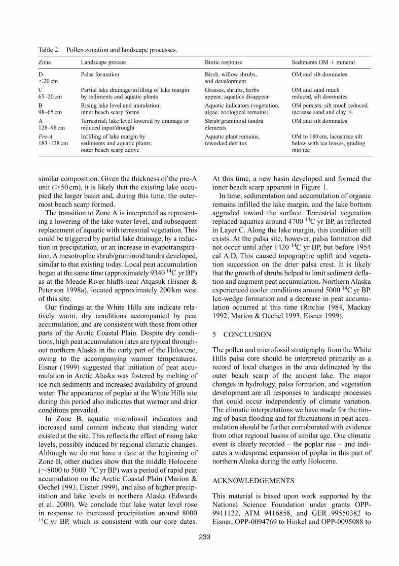
Figure 2. White Hill core textural and compositionalanalysis.
Carbon stored in the palsa amounts to 135 kg C m�3,greater than that reported from other sites on Alaska’sNorth Slope (Michaelson et al. 1996).
Results from AMS dating are reported in Table 1, and confirm that the palsa contains organic sedimentsencompassing at least the entire Holocene. The consis-tency of the dates demonstrates stratigraphic integritythroughout the 9,000 yr record.
We also obtained dates from plant material in thelower core (128–183 cm), as indicated in Table 1.Although marginally younger than the sediments imme-diately above, this unit was interspersed with plantroots, making precise dating problematic. The dates,and the composition of the material, indicate that thesesediments represent a basal detrital unit composed oferoded, reworked, and redeposited peat, organic silts,and roots of aquatic plants (Hopkins & Kidd 1988). Thisunit was deposited in a lacustrine environment, and haslittle stratigraphic integrity. The pollen and microfossilswere derived from older reworked materials, or couldhave been transported from elsewhere in the watershed.Because the pollen and microfossils represent a vari-ety of environments, we concluded that this layer(128–183 cm) was unsuitable for detailed analysis.
Initially we hypothesized that a comparison of pollenstratigraphy from the palsa summit and the adjacentbog sediment, combined with dating at the point ofdivergence between the two pollen signals, should
indicate the timing of frost mound incipience. However,the core collected from the adjacent lake margin bogwas found to contain modern aquatic plant roots in theupper 26 cm, and this was immediately underlain bylacustrine silts. Lacking a thick sequence of peat todate, we chose to discontinue further analysis of the bogcore and focus exclusively on the palsa.
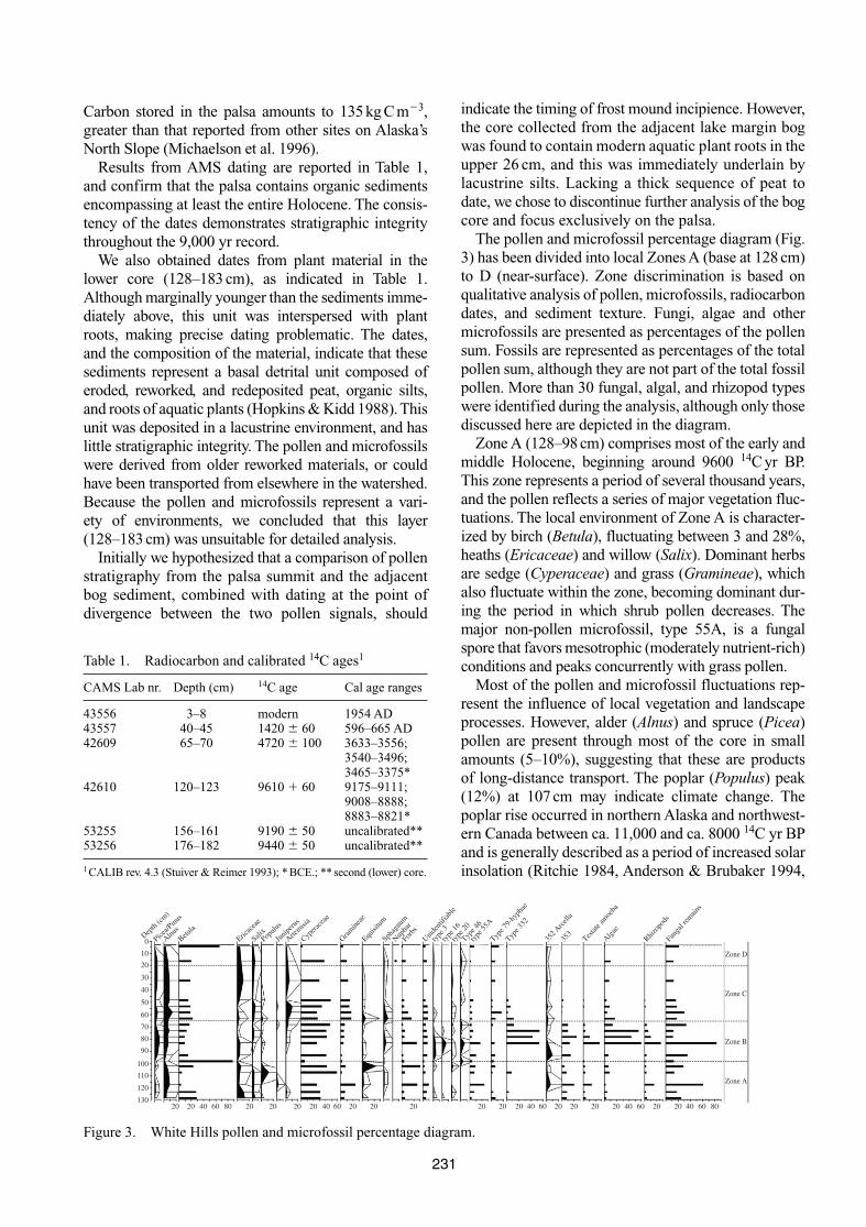
The pollen and microfossil percentage diagram (Fig.3) has been divided into local Zones A (base at 128 cm)to D (near-surface). Zone discrimination is based onqualitative analysis of pollen, microfossils, radiocarbondates, and sediment texture. Fungi, algae and othermicrofossils are presented as percentages of the pollensum. Fossils are represented as percentages of the totalpollen sum, although they are not part of the total fossilpollen. More than 30 fungal, algal, and rhizopod typeswere identified during the analysis, although only thosediscussed here are depicted in the diagram.
Zone A (128–98 cm) comprises most of the early andmiddle Holocene, beginning around 9600 14C yr BP.This zone represents a period of several thousand years,and the pollen reflects a series of major vegetation fluc-tuations. The local environment of Zone A is character-ized by birch (Betula), fluctuating between 3 and 28%,heaths (Ericaceae) and willow (Salix). Dominant herbsare sedge (Cyperaceae) and grass (Gramineae), whichalso fluctuate within the zone, becoming dominant dur-ing the period in which shrub pollen decreases. Themajor non-pollen microfossil, type 55A, is a fungalspore that favors mesotrophic (moderately nutrient-rich)conditions and peaks concurrently with grass pollen.
Most of the pollen and microfossil fluctuations rep-resent the influence of local vegetation and landscapeprocesses. However, alder (Alnus) and spruce (Picea)pollen are present through most of the core in smallamounts (5–10%), suggesting that these are products of long-distance transport. The poplar (Populus) peak(12%) at 107 cm may indicate climate change. Thepoplar rise occurred in northern Alaska and northwest-ern Canada between ca. 11,000 and ca. 8000 14C yr BPand is generally described as a period of increased solarinsolation (Ritchie 1984, Anderson & Brubaker 1994,
231
Table 1. Radiocarbon and calibrated 14C ages1
CAMS Lab nr. Depth (cm) 14C age Cal age ranges
43556 3–8 modern 1954 AD43557 40–45 1420 � 60 596–665 AD42609 65–70 4720 � 100 3633–3556;
3540–3496;3465–3375*
42610 120–123 9610 � 60 9175–9111;9008–8888;8883–8821*
53255 156–161 9190 � 50 uncalibrated**53256 176–182 9440 � 50 uncalibrated**
1CALIB rev. 4.3 (Stuiver & Reimer 1993); * BCE.; ** second (lower) core.
Depth
(cm)
Picea/P
inus
Alnus
Betula
Ericac
eae
SalixPop
ulus
Junip
erus
Artemisi
a
Cypera
ceae
Gram
inea
eEqu
isitu
mSph
agnu
mNup
har
Forbs
Unide
ntifi
able
type
3ty
pe 16
type
20Typ
e 46
type
55A
Type 7
9-hy
phae
Type 3
32
352 A
rcell
a
Testat
e am
oeba
Rhizo
pods
Algae
Funga
l rem
ains
353
0
10
20
30
40
50
60
70
80
90
100
110
120
13020 20 40 60 80 20 20 20 20 20 20 20 20 20 20 20 20 20 20 40 60 20 20 40 60 80
Zone A
Zone B
Zone C
Zone D
40 6040 60
Figure 3. White Hills pollen and microfossil percentage diagram.
Bartlein et al. 1995). Poplar pollen does not have a widedispersal range (Edwards & Dunwiddie 1985), and thepercentages found at this level may indicate establish-ment of a localized poplar grove some time after 960014C yr BP and before 4720 14C yr BP.
Sediments in Zone A (Fig. 2) contain a large compo-nent of organic material (25–35%) and silt (35–45%),with 15–25% sand and clay sized particles. These pro-portions are similar to those near the surface (Zone D),and the mineral fraction may be of aeolian origin.
The pollen, microfossils, and sediment texture/com-position evidence from Zone A indicate that a terres-trial, mesotrophic shrub/graminoid tundra, consistingmainly of low willow, birch, sedges and grasses, existedduring this entire period.
The transition from Zone A to Zone B (98–65 cm) ismarked by a sharp increase in horsetail (Equisitum) to23%, which may be indicative of surface disturbance. Anabrupt rise in birch pollen occurs at 98 cm (87%), fol-lowed by an abrupt return to moderate levels. The birchspike probably reflects the expansion of local birch, orpossibly even birch catkins incorporated into the sedi-ment, since much of the sample was composed of birchpollen clusters. The remainder of Zone B (98–65 cm) ismarked by high frequencies of Cosmarium turpini (Type332B), a pioneering species of green algae preferringlow-nutrient aquatic environments and typically flour-ishing in shallow, sandy pools. Rapid growth of thisalgae could have been encouraged when the supply ofnutrients from groundwater was cut off and the primarynutrient source was meteoric water. Several fungalremains and rhizopods (or Thecamoebe) are notable:Centropyxis aculeata Ehrenberg (Type WH8) is aninvertebrate adapted to living in highly acidic environ-ments of wet mosses and Sphagnum. Sphagnum percent-ages rise concurrently with Type WH8 in Zone B. Anabundant fossil in this zone is Type 353B, eggs of aquaticflatworm Microdalyellia armigera, typical of eutrophicenvironments. Conversely, Type 352 (Arcella), whichshows up in the early part of the zone, is typical of nutri-ent-poor environments. Despite their conflicting signalsin terms of nutrient levels, both rhizopods are indicativeof an aquatic environment. The vascular plants alsoreflect this change, with sedges dominant throughout theperiod and dry-ground vegetation such as birch, willow,and grass at relatively low levels.
Textural and compositional analysis (Fig. 2) demon-strate an increase in the coarse (sand) and very fine(clay) mineral fraction, with a concurrent reduction inthe silt component. The increased presence of sandindicates that Zone B formed in a higher energy envi-ronment than Zone A. The organic component remainshigh, but decreases steadily upsection. Based on thevarious lines of evidence, there appears to have been a shift to an aquatic environment. We interpret thisperiod as one of inundation from rising lake levels and
increased peat accumulation along the Sphagnum/sedge bogs of the lake margin.
Zone C (65–20 cm) shows a long period of increas-ingly terrestrial conditions, indicated by the preva-lence of birch (15–22%), heath (1–10%), and willow(2–5%). Sage (Artemisia) pollen increases for the firsttime (to 10%). The zone is again introduced by a rise,although smaller, of Equisitum. Zone C also containslarge amounts of fungal hyphae (Type 79) which is typically an indication of increased biotic activity andsoil formation. Most of the aquatic species (C. turpin,C. aculeate E., and M. armigera) that were present inZone B decline dramatically.
Zone C shows a pronounced decline in organic mat-ter. The coarse mineral component virtually disappears,silt dominates (�70%), and the clay fraction increasesto around 25%. These trends indicate a period of partiallake drainage around 4700 14C yr BP, with a consequentlowering of the lake’s water level. The site, located nearthe margins of the smaller basin, was at least partiallydrained. Soil formation was initiated at this time. Thefine mineral fraction was delivered by aeolian processesor during episodic inundation events.
Zone D (20 cm to surface) is problematic for theanalysis of discreet intervals due to rooting by shrubsand herbs, which can cause penetration of olderdeposits by younger material. Although one water lilypollen grain (Nuphar) was found at a depth of 16 cm,it is highly unlikely that the site was under water; animal importation or bioturbation is more likely. Ingeneral, the pollen closely reflects present-day vege-tation at the crest of the palsa, with very high birchpercentages (68%), some heath, willow, and sage, anda sharp decline in sedge and grass. Fungal hyphae riseagain in this zone, as does fungal type 55A. Theorganic matter component increases from �10% to40% across the Zone C-D transition, and the propor-tion of silt and clay decreases.
It is very likely that the transition between Zones Cand D reflects palsa formation, followed by birchshrub growth and the initiation of soil formation. Thedates indicate that this event took place at some timebetween 1420 14C yr BP and the present.
4 DISCUSSION
Interpretation of the core data, which varies inresponse to local landscape changes, is summarized inTable 2. The lowermost layer (pre-A) is interpreted asa basal detrital unit deposited above lacustrine silts.The environmental setting is typical of shallow lakemargins vegetated with Carex. Over time organics accu-mulate and water shallows, and eventually the surfaceis at or near the lake water level. A similar setting is present today along the lake margin, and the corecollected from the bog adjacent to the palsa has a
232
similar composition. Given the thickness of the pre-Aunit (�50 cm), it is likely that the existing lake occu-pied the larger basin and, during this time, the outer-most beach scarp formed.
The transition to Zone A is interpreted as represent-ing a lowering of the lake water level, and subsequentreplacement of aquatic with terrestrial vegetation. Thiscould be triggered by partial lake drainage, by a reduc-tion in precipitation, or an increase in evapotranspira-tion. A mesotrophic shrub/graminoid tundra developed,similar to that existing today. Local peat accumulationbegan at the same time (approximately 9340 14C yr BP)as at the Meade River bluffs near Atqasuk (Eisner &Peterson 1998a), located approximately 200 km westof this site.
Our findings at the White Hills site indicate rela-tively warm, dry conditions accompanied by peat accumulation, and are consistent with those from otherparts of the Arctic Coastal Plain. Despite dry condi-tions, high peat accumulation rates are typical through-out northern Alaska in the early part of the Holocene,owing to the accompanying warmer temperatures.Eisner (1999) suggested that initiation of peat accu-mulation in Arctic Alaska was fostered by melting ofice-rich sediments and increased availability of groundwater. The appearance of poplar at the White Hills siteduring this period also indicates that warmer and drierconditions prevailed.
In Zone B, aquatic microfossil indicators andincreased sand content indicate that standing waterexisted at the site. This reflects the effect of rising lakelevels, possibly induced by regional climatic changes.Although we do not have a date at the beginning ofZone B, other studies show that the middle Holocene(�8000 to 5000 14C yr BP) was a period of rapid peataccumulation on the Arctic Coastal Plain (Marion &Oechel 1993, Eisner 1999), and also of higher precip-itation and lake levels in northern Alaska (Edwards et al. 2000). We conclude that lake water level rose in response to increased precipitation around 800014C yr BP, which is consistent with our core dates.
At this time, a new basin developed and formed theinner beach scarp apparent in Figure 1.
In time, sedimentation and accumulation of organicremains infilled the lake margin, and the lake bottomaggraded toward the surface. Terrestrial vegetationreplaced aquatics around 4700 14C yr BP, as reflectedin Layer C. Along the lake margin, this condition stillexists. At the palsa site, however, palsa formation didnot occur until after 1420 14C yr BP, but before 1954cal A.D. This caused topographic uplift and vegeta-tion succession on the drier palsa crest. It is likely that the growth of shrubs helped to limit sediment defla-tion and augment peat accumulation. Northern Alaskaexperienced cooler conditions around 5000 14C yr BP.Ice-wedge formation and a decrease in peat accumu-lation occurred at this time (Ritchie 1984, Mackay1992, Marion & Oechel 1993, Eisner 1999).
5 CONCLUSION
The pollen and microfossil stratigraphy from the WhiteHills palsa core should be interpreted primarily as arecord of local changes in the area delineated by theouter beach scarp of the ancient lake. The majorchanges in hydrology, palsa formation, and vegetationdevelopment are all responses to landscape processesthat could occur independently of climate variation.The climatic interpretations we have made for the tim-ing of basin flooding and for fluctuations in peat accu-mulation should be further corroborated with evidencefrom other regional basins of similar age. One climaticevent is clearly recorded – the poplar rise – and indi-cates a widespread expansion of poplar in this part ofnorthern Alaska during the early Holocene.
ACKNOWLEDGEMENTS
This material is based upon work supported by theNational Science Foundation under grants OPP-9911122, ATM 9416858, and GER 99550382 toEisner, OPP-0094769 to Hinkel and OPP-0095088 to
233
Table 2. Pollen zonation and landscape processes.
Zone Landscape process Biotic response Sediments OM � mineral
D Palsa formation Birch, willow shrubs, OM and silt dominates�20 cm soil development
C Partial lake drainage/infilling of lake margin Grasses, shrubs, herbs OM and sand much 65–20 cm by sediments and aquatic plants appear; aquatics disappear reduced, silt dominates
B Rising lake level and inundation; Aquatic indicators (vegetation, OM persists, silt much reduced,98–65 cm inner beach scarp forms algae, zoological remains) increase sand and clay %
A Terrestrial; lake level lowered by drainage or Shrub/graminoid tundra OM and silt dominates128–98 cm reduced input/drought elements
Pre-A Infilling of lake margin by Aquatic plant remains, OM to 180 cm, lacustrine silt 183–128 cm sediments and aquatic plants; reworked detritus below with ice lenses, grading
outer beach scarp active into ice
Nelson. Any opinions, findings, conclusions, or rec-ommendations expressed in the material are those ofthe authors and do not necessarily reflect the views of the National Science Foundation. The authors wouldlike to thank Kim Peterson and Lynn Everett for theirinvaluable assistance.
REFERENCES
Anderson, P.M. & Brubaker, L.B. 1994. Vegetation historyof northcentral Alaska: a mapped summary of late-Quaternary pollen data. Quaternary Science Reviews13: 71–92.
Bartlein, P.J., Edwards, M.E., Shafer, S.L. & Barker, E.D.1995. Calibration of radiocarbon ages and the inter-pretation of paleoenvironmental records. QuaternaryResearch 44: 417–424.
Berglund, B.E. & Ralska-Jasiewiczowa, M. 1986. Pollenanalysis and pollen diagrams. In Berglund, B.E. (ed.),Handbook of Holocene Paleoecology and Paleo-hydrology. John Wiley & Sons: 455–484.
Edwards, M.E., Bigelow, N.H., Finney, B.P. & Eisner, W.R.2000. Records of aquatic pollen and sediment pro-perties as indicators of late-Quaternary Alaskan lake levels. Journal of Paleolimnology 24(1): 55–68.
Edwards, M.E. & Dunwiddie, P.W. 1985. Dendrochrono-logical and palynological observations on Populus balsamifera in northern Alaska, U.S.A. Arctic andAlpine Research 17: 271–278.
Eisner, W.R. 2000. Overview of Arctic Microfossils. Paleo-environmental Arctic Sciences (PARCS), NSF ArcticSystems Science, www.ngdc.noaa.gov/paleo/ parcs/.
Eisner, W.R. & Peterson, K.M. 1998a. High-resolutionpollen analysis of tundra polygons from the NorthSlope of Alaska. Journal of Geophysical Research103(D22): 28, 929–28, 937.
Eisner, W.R. & Peterson, K.M. 1998b. Pollen, fungi andalgae as age indicators of drained lake basins nearBarrow, Alaska. In A.G. Lewkowicz & M. Allard (eds),7th International Conference on Permafrost, Yellow-knife, Canada. Laval, Quebec: Centre de etudesnordiques de l’Universite Laval.
Eisner, W.R. 1999. Climate Change and Spatial Diversityof Vegetation during the Late Quaternary of Beringia.Utrecht: University of Utrecht.
Gurney, S.D. 2001. Aspects of the genesis, geomorphologyand terminology of palsas: perennial cryogenic mounds.Progress in Physical Geography 25(2): 249–260.
Hopkins, D.M. & Kidd, J.G. 1988. Thaw lake sediments andsedimentary environments. Trondheim: Permafrost 5thInternational Conference: 790–795.
Lavoie, C. & Payette, S. 1995. Analyse macrofossile d’unepalse subarctique (Quebec nordique). Canadian Jour-nal of Botany 73: 527–537.
MacKay, J.R. 1992. Lake stability in an ice-rich permafrostenvironment: examples from the western Arctic coast.In Robarts, R.D. & Bothwell, M.L. (eds), AquaticEcosystems in Semi-Arid Regions: Implications forResource Management. N.H.R.I. Symposium Series.Environment Canada: 1–25.
Marion, G.M. & Oechel, W. C. 1993. Mid- to late-Holocenecarbon balance in Arctic Alaska and its implicationsfor future global warming. Holocene 3(3): 193–200.
Michaelson, G.J., Ping, C.L. & Kimble, J.M. 1996. Carbonstorage and distribution in tundra soils of Arctic Alaska,U.S.A. Arctic and Alpine Research 28(4): 414–424.
Nelson, F.E., Hinkel, K.M. & Outcalt, S.I. 1992. Palsa-scale frost mounds. In Dixon, J.C. & Abrahams, A.D.(eds), Periglacial Geomorphology: Proceedings of the 22nd Annual Binghampton Symposium in Geo-morphology. John Wiley & Sons: 305–326.
Railton, J.B. & Sparling, J.M. 1973. Preliminary studies onthe ecology of palsa mounds in Northern Ontario.Canadian Journal of Botany 51: 1037–1044.
Ritchie, J.C. 1984. Past and Present Vegetation of the Far Northwest of Canada. Toronto: University ofToronto Press.
Seppälä, M. 1990. Depth of snow and frost on a palsa mire,Finnish Lapland. Geografiska Annaler 72A: 191–201.
Soil Survey Staff, 1996. Soil Survey Methods Manual. Soil Survey Investigations Report Number 42, V. 3.0.USDA.
Sjörs, H. 1961. Forest and peatlands at Hawly Lake, northernOntario. Contributions to Botany, National Museum ofCanada 171: 1–31.
Stuiver, M. & Reimer, P. J. 1993. Extended 14C data base and revised CALIB radiocarbon calibration program.Radiocarbon 35: 215–230.
Van Geel, B. 1978. A palaeoecological study of Holocenepeat bog sections in Germany and The Netherlands.Review of Palaeobotany and Palynology 25: 1–120.
Van Geel, B. 1986. Application of fungal and algal remainsand other microfossils in palynological analyses. InBerglund, B.E. (ed.), Handbook of Holocene Paleoecol-ogy and Paleohydrology. John Wiley & Sons: 497–505.
Vorren, K.-D. 1972. Stratigraphical investigations of apalsa bog in northern Norway. Astarte 5: 39–71.
Vorren, K.-D. 1979a. Recent palsa datings, a brief survey.Norsk Geografisk Tidsskrift 33: 217–219.
Vorren, K.-D. 1979b. Vegetational investigations of a palsabog in northern Norway. Tromso Museums Rapport-serie, Naturvitenskap, 5.
Vorren, K.-D. & Vorren, B. 1975. The problem of dating a palsa: two attempts involving pollen diagrams,determination of moss subfossils, and C-14 datings.Astarte 8: 73–81.
Washburn, A.L. 1983a. Palsas and continuous permafrost.In Proceedings of the Fourth International Conferenceon Permafrost. Washington, D.C.: National AcademyPress 1: 1372–1377.
Washburn, A.L. 1983b. What is a palsa? In Poser, H. &Schunke, E. (eds), Mesoformen des Reliefs im heuti-gen Periglazialraum: Bericht über ein Symposium.Abhandlungen der Akademie der Wissenschaften in Göttingen, Mathematisch-Physikalische Klasse,Göttingen 35: 34–47.
Willmott, C.J. & Matsuura, K. 2001. Terrestrial air temper-ature and precipitation: monthly and annual timeseries (1950–1999), version 1.02. Global ClimateResource Pages: climate.geog.udel.edu/~climate.
234