Embed Size (px)
Citation preview
LATE SCOPING CONSULTATION RESPONSES
Consultation bodies have 28 days to respond with any comments, stating either the information that they consider should be included in the ES or
that they do not have any comments.
Any responses received after the deadline are not considered within the scoping opinion but are forwarded to the applicant for consideration in accordance with the policy set out in Advice Note 7: Environmental Impact
Assessment, Screening and Scoping.
The following EIA scoping consultation responses were received after the consultation deadline specified under legislation and therefore did not form part of the Secretary of State's scoping opinion.
Date: 1 April 2015
From: Stirling, VickyTo: Environmental ServicesSubject: Keadby Wind Farm Extension - Scoping Consultation - NGDate: 25 March 2015 09:00:35Attachments: 180315 - Keadby Wind Farm Extension - Scoping Consultation.pdf
NGG & NGET Assets.pdf
Dear Sirs Please find attached a response on behalf of National Grid Gas Plc and National Grid ElectricityTransmission Plc to the above consultation. Kind RegardsVicky Vicky Stirling DCO Liaison OfficerLand & Business Support, Network Engineering National Grid +44(0)1926 653746 +44(0)7747 671508 P Please consider the environment before printing this email
This e-mail, and any attachments are strictly confidential and intended for theaddressee(s) only. The content may also contain legal, professional or otherprivileged information. If you are not the intended recipient, please notify thesender immediately and then delete the e-mail and any attachments. You shouldnot disclose, copy or take any action in reliance on this transmission.
You may report the matter by contacting us via our UK Contacts Page or our USContacts Page (accessed by clicking on the appropriate link)
Please ensure you have adequate virus protection before you open or detach anydocuments from this transmission. National Grid plc and its affiliates do notaccept any liability for viruses. An e-mail reply to this address may be subject tomonitoring for operational reasons or lawful business practices.
For the registered information on the UK operating companies within the NationalGrid group please use the attached link:http://www.nationalgrid.com/corporate/legal/registeredoffices.htm This email was scanned by the Government Secure Intranet anti-virus servicesupplied by Vodafone in partnership with Symantec. (CCTM Certificate Number2009/09/0052.) In case of problems, please call your organisations IT Helpdesk.Communications via the GSi may be automatically logged, monitored and/orrecorded for legal purposes.
National Grid house Warwick Technology Park Gallows Hill, Warwick CV34 6DA
National Grid is a trading name for: National Grid is a trading name for: National Grid Electricity Transmission plc National Grid Gas plc Registered Office: 1-3 Strand, London WC2N 5EH Registered Office: 1-3 Strand, London WC2N 5EH Registered in England and Wales, No 2366977 Registered in England and Wales, No 2006000
3/18 Eagle Wing Temple Quay House 2 The Square Bristol BS1 6PN
Land and Development Group Vicky Stirling DCO Liaison Officer Network Engineering [email protected] Direct tel: +44 (0)1926 653746
SUBMITTED VIA EMAIL TO: [email protected]
www.nationalgrid.com
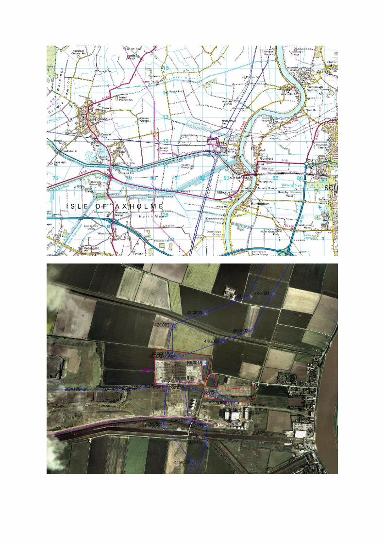
18 March 2015 Dear Sir/Madam, Scoping Consultation Application by Keadby Wind Farm Ltd for an Order Granting Development Consent for the Keadby Wind Farm Extension This is a joint response by National Grid Electricity Transmission plc (NGET) and National Grid Gas plc (NGG) I refer to your letter dated 24th February 2015 regarding the above proposed application. Having reviewed the Scoping consultation documents, I would like to make the following comments: National Grid Infrastructure within or in close proximity to the Proposed Order Limits National Grid Electricity Transmission
National Grid Electricity Transmission has a number of high voltage electricity overhead transmission lines which lie within or in close proximity to the proposed order limits. These lines form an essential part of the electricity transmission network in England and Wales and include the following:
ZDA (400kV) overhead line 4TM (400kV) overhead line KKP (400kV) overhead line 4KG (400kV) overhead line 4ZQ (400kV) overhead line
The following substation is also located within or in close proximity to the proposed order limits:
Keadby (400kV) Substation I enclose plans showing the routes of our overhead lines and the location of our substation within the area shown in the consultation documents. The following points should be taken into consideration:
National Grid house Warwick Technology Park Gallows Hill, Warwick CV34 6DA
National Grid is a trading name for: National Grid is a trading name for: National Grid Electricity Transmission plc National Grid Gas plc Registered Office: 1-3 Strand, London WC2N 5EH Registered Office: 1-3 Strand, London WC2N 5EH Registered in England and Wales, No 2366977 Registered in England and Wales, No 2006000
National Grid’s Overhead Line/s is protected by a Deed of Easement/Wayleave Agreement
which provides full right of access to retain, maintain, repair and inspect our asset
Statutory electrical safety clearances must be maintained at all times. Any proposed buildings must not be closer than 5.3m to the lowest conductor. National Grid recommends that no permanent structures are built directly beneath overhead lines. These distances are set out in EN 43 – 8 Technical Specification for “overhead line clearances Issue 3 (2004)
available at: http://www.nationalgrid.com/uk/LandandDevelopment/DDC/devnearohl final/appendixIII/appIII-part2
If any changes in ground levels are proposed either beneath or in close proximity to our
existing overhead lines then this would serve to reduce the safety clearances for such overhead lines. Safe clearances for existing overhead lines must be maintained in all circumstances.
Further guidance on development near electricity transmission overhead lines is available
here: http://www.nationalgrid.com/NR/rdonlyres/1E990EE5-D068-4DD6-8C9A-4D0B06A1BA79/31436/Developmentnearoverheadlines1.pdf
The relevant guidance in relation to working safely near to existing overhead lines is
contained within the Health and Safety Executive’s (www.hse.gov.uk) Guidance Note GS 6 “Avoidance of Danger from Overhead Electric Lines” and all relevant site staff should
make sure that they are both aware of and understand this guidance.
Plant, machinery, equipment, buildings or scaffolding should not encroach within 5.3 metres of any of our high voltage conductors when those conductors are under their worse conditions of maximum “sag” and “swing” and overhead line profile (maximum “sag” and
“swing”) drawings should be obtained using the contact details above.
If a landscaping scheme is proposed as part of the proposal, we request that only slow and low growing species of trees and shrubs are planted beneath and adjacent to the existing overhead line to reduce the risk of growth to a height which compromises statutory safety clearances.
Drilling or excavation works should not be undertaken if they have the potential to disturb
or adversely affect the foundations or “pillars of support” of any existing tower. These
foundations always extend beyond the base area of the existing tower and foundation (“pillar of support”) drawings can be obtained using the contact details above
National Grid Gas Transmission National Grid has a high pressure gas transmission pipeline located within or in close proximity to the proposed order limits. The high pressure gas pipeline located within this area is:
FM07 - Cawood to Susworth T West FM07 – Eastcroft to Keadby PS
National Grid house Warwick Technology Park Gallows Hill, Warwick CV34 6DA
National Grid is a trading name for: National Grid is a trading name for: National Grid Electricity Transmission plc National Grid Gas plc Registered Office: 1-3 Strand, London WC2N 5EH Registered Office: 1-3 Strand, London WC2N 5EH Registered in England and Wales, No 2366977 Registered in England and Wales, No 2006000
National Grid Gas Distribution National Grid Gas Distribution has no apparatus within the order limits. Specific Comments – Gas Infrastructure The following points should be taken into consideration:
National Grid has a Deed of Grant of Easement for each pipeline, which prevents the erection of permanent / temporary buildings, or structures, change to existing ground levels, storage of materials etc.
Pipeline Crossings:
Where existing roads cannot be used, construction traffic should ONLY cross the pipeline at previously agreed locations.
The pipeline shall be protected, at the crossing points, by temporary rafts constructed at
ground level. The third party shall review ground conditions, vehicle types and crossing frequencies to determine the type and construction of the raft required.
The type of raft shall be agreed with National Grid prior to installation.
No protective measures including the installation of concrete slab protection shall be
installed over or near to the National Grid pipeline without the prior permission of National Grid.
National Grid will need to agree the material, the dimensions and method of installation of
the proposed protective measure.
The method of installation shall be confirmed through the submission of a formal written method statement from the contractor to National Grid.
Please be aware that written permission is required before any works commence within the
National Grid easement strip.
A National Grid representative shall monitor any works within close proximity to the pipeline to comply with National Grid specification T/SP/SSW22.
A Deed of Consent is required for any crossing of the easement Cables Crossing:
Cables may cross the pipeline at perpendicular angle to the pipeline i.e. 90 degrees.
A National Grid representative shall supervise any cable crossing of a pipeline.
Clearance must be at least 600mm above or below the pipeline.
National Grid house Warwick Technology Park Gallows Hill, Warwick CV34 6DA
National Grid is a trading name for: National Grid is a trading name for: National Grid Electricity Transmission plc National Grid Gas plc Registered Office: 1-3 Strand, London WC2N 5EH Registered Office: 1-3 Strand, London WC2N 5EH Registered in England and Wales, No 2366977 Registered in England and Wales, No 2006000
Impact protection slab should be laid between the cable and pipeline if cable crossing is above the pipeline.
A Deed of Consent is required for any cable crossing the easement.
Where a new service is to cross over the pipeline a clearance distance of 0.6 metres
between the crown of the pipeline and underside of the service should be maintained. If this cannot be achieved the service shall cross below the pipeline with a clearance distance of 0.6 metres.
General Notes on Pipeline Safety:
You should be aware of the Health and Safety Executives guidance document HS(G) 47 "Avoiding Danger from Underground Services", and National Grid’s specification for Safe
Working in the Vicinity of National Grid High Pressure gas pipelines and associated installations - requirements for third parties T/SP/SSW22.
National Grid will also need to ensure that our pipelines access is maintained during and after construction.
Our pipelines are normally buried to a depth cover of 1.1 metres however; actual depth and position must be confirmed on site by trial hole investigation under the supervision of a National Grid representative. Ground cover above our pipelines should not be reduced or increased.
If any excavations are planned within 3 metres of National Grid High Pressure Pipeline or,
within 10 metres of an AGI (Above Ground Installation), or if any embankment or dredging works are proposed then the actual position and depth of the pipeline must be established on site in the presence of a National Grid representative. A safe working method agreed prior to any work taking place in order to minimise the risk of damage and ensure the final depth of cover does not affect the integrity of the pipeline.
Excavation works may take place unsupervised no closer than 3 metres from the pipeline
once the actual depth and position has been has been confirmed on site under the supervision of a National Grid representative. Similarly, excavation with hand held power tools is not permitted within 1.5 metres from our apparatus and the work is undertaken with NG supervision and guidance.
To view the SSW22 Document, please use the link below: http://www2.nationalgrid.com/uk/Safety/library/ To download a copy of the HSE Guidance HS(G)47, please use the following link: http://www.hse.gov.uk/pubns/books/hsg47.htm Further information in relation to National Grid’s gas transmission pipelines can be accessed via
the following internet link: http://www.nationalgrid.com/uk/LandandDevelopment/DDC/gastransmission/gaspipes/

From: Mark BeeversTo: Richard KentSubject: EN010070 – Keadby Wind Farm Extension – EIA Scoping Notification and ConsultationDate: 30 March 2015 18:18:13
Dear Richard, Thank you for your letter dated 25th February 2015 requesting the views of NorthLincolnshire Council on the Scoping Request submitted for the extension of KeadbyWind Farm. Apologies for the delayed response to this request. I have consulted withinternal consultees and I am awaiting responses which I will forward to you as theyare received, I am aware that these will be too late for you to consider in preparingyour Scoping Opinion but I am happy for these to be forwarded to the applicants. At this stage I would like to highlight the proliferation of wind turbines in this localityand the importance of considering cumulative impacts when assessing all elements ofthis scheme. Due to this proliferation the applicants stated 1 kilometre threshold for consideringresidential amenity is considered to be inadequate. The Isle of Axholme is a flatlandscape which already contains a number of wind turbines. This application has thepotential to further detract from the amenity afforded to residential properties andincrease the prominence and/or spread of turbines visible from residential propertiesand their curtilages. This concern predominantly relates to residential properties tothe west and north of the proposed site where existing and proposed turbines combineto encircle properties and villages. The cumulative effect of wind turbine developmentin this landscape is considered to require a wider consideration of residential amenitywhich should clearly inform the layout and amount of new development. The list of proposed/consented/constructed turbines is incomplete, application numberWF/2014/0710 is currently submitted and proposes six 126.5 metre high turbines tothe west of Crowle. It is however noted that the Figure 5 plan has identified thisscheme and this plan appears to be complete. Aviation safety is given very little reference in the submitted report, however, recentapplications in the area have resulted in objections being raised. Subject toconsultation this element may need to be expanded. Humberside Airport has beenexcluded from the consultee list and I would recommend that this airport is included. All technical elements of the ES would be expected to follow best practice. If technicalconsultees do raise any concerns I will forward these to you as stated at the outset ofthis email. Apologies again for this late response and please do not hesitate to contact me on thedetails below should you wish to discuss. Kind Regards Mark BeeversPrincipal Strategic Development OfficerTel: 01724 297505Mob: 07773 189545Email: [email protected] e-mail expresses the opinion of the author and is not necessarily the view ofthe Council. Please be aware that anything included in an e-mail may have to bedisclosed under the Freedom of Information Act and cannot be regarded asconfidential. This communication is intended for the addressee(s) only. Pleasenotify the sender if received in error. All Email is monitored and recorded.Please think before you print- North Lincolnshire Council greening the workplace

This email was scanned by the Government Secure Intranet anti-virus servicesupplied by Vodafone in partnership with Symantec. (CCTM Certificate Number2009/09/0052.) In case of problems, please call your organisations IT Helpdesk.Communications via the GSi may be automatically logged, monitored and/orrecorded for legal purposes.
• Foraging bats • Badger • Great crested newts • Other protected and priority species where extended Phase 1 survey
reveals potential. Existing Biodiversity Value The application site is largely arable farmland, with canals, drains and hedgerows. A conservation management plan for the existing windfarm. Has provided biodiversity enhancement in terms of improved habitats for protected and priority species of farmland and wetlands. The Environmental Statement should include a description and assessment of existing habitats on site and of statutory and non-statutory protected sites nearby, including SAC, SPA, Ramsar, SSSIs and Local Sites, along with any potential impact on these features. Desktop data should include information from the Lincolnshire Environmental Records Centre. Biodiversity Enhancement The National Planning Policy Framework states that: “The planning system should contribute to and enhance the natural and local environment by: • protecting and enhancing valued landscapes, geological conservation
interests and soils; • recognising the wider benefits of ecosystem services; • minimising impacts on biodiversity and providing net gains in biodiversity
where possible, contributing to the Government’s commitment to halt the overall decline in biodiversity, including by establishing coherent ecological networks that are more resilient to current and future pressures...”
and “opportunities to incorporate biodiversity in and around developments should be encouraged;” With this application, biodiversity enhancement should be secured by extension and enhancement of the Conservation Management Plan approach already adopted. Enhancement of of-site Local Wildlife Sites may also be of value. If you have any questions, please do not hesitate to contact me. Andrew Taylor Project Officer (Ecologist)
Page 2 of 2
I N T E R
O F F I C E
MEMO
To: Mark Beevers, Development Management From: Environmental Health (Commercial) Your Ref: Scoping Opinion – Proposed wind farm extension Our Ref PLU 1589 Subject: Keadby Wind Farm Land next to Keadby Power Station, Keadby North Lincolnshire Date: 14 April 2015 Thank you for email of 30 March 2015requesting this department’s comments on the EIA Scoping Report dated February 2015, referenced B1486010 and prepared by Jacobs UK Ltd for the applicant SSE Renewables Developments (UK) Ltd. I can confirm that this department has reviewed the report and has the following comments which should be provided to the applicant to assist in the preparation of the Environmental Impact Assessment. 1. Operational Noise The scoping report lists the appropriate guidance for the assessment of noise (in section 6.8.4). Paragraph 123 of The Framework states that planning decisions should aim to “identify and protect areas of tranquillity which have remained relatively undisturbed by noise and are prized for their recreational and amenity value for this reason.” I am not aware of any such recreational/amenity areas within or close to the development boundary, so unless the planning department is aware of any such areas here, the consideration of noise impact in this case would relate only to residential amenity. This application is for an extension to the existing wind farm with established noise limits. Reference to the ETSU and Institute of Acoustics Good Practice Guidance indicates that the cumulative noise levels from the existing and proposed new turbines together should not exceed the existing ETSU-derived noise limits specified in the current planning permission . As stated on page 38 of the scoping report, I confirm that discussions have already taken place with the applicant’s noise consultant. It has been agreed that appropriate background noise data obtained before the existing wind farm was built may be
Keadby Wind Farm Scoping. Envoironmental Health comments 14/04/15 Page 1 of 3
suitable to use in assessment of impacts and in deciding what noise limits would apply at relevant locations. The application for extension of the wind farm will need to provide sufficient information to justify the choice of background data that will be used to establish noise limits for all relevant residential locations. In order to understand the noise impact of the proposal it will also be necessary for the application to provide information for all relevant locations to show what the existing turbine noise levels are and what the predicted cumulative noise level will be with the addition of the proposed new turbines. The applicant’s Operational Noise Survey (report ref: PJ3275/11240, dated July 2014) indicates that the existing noise limits are being complied with for the existing wind farm. It should also be noted that North Lincolnshire Council is currently investigating a complaint from a local resident who has reported that noise from the operation of the turbines at Keadby Wind Farm has given rise to noise disturbance and nuisance. 2. Noise and vibration during construction and decommissioning I agree that noise and vibration impacts associated with construction and decommissioning work should be assessed with reference to BS5228. The application should also include information on relevant mitigation measures and predictions of resulting impact at relevant locations. I would recommend that the application should include sufficient detail to show how the control of noise and vibration would be addressed in the CEMP. 3. Shadow Flicker An assessment of shadow flicker will be required to ensure that controls can be included where necessary to protect residential amenity. 4. Contaminated Land Section 6.2 discusses Hydrology, Hydrogeology, Geology and Soils and the impact upon these during construction and operation of the proposed wind farm extension. There is no reference to unknown contamination and how this would be addressed. Whilst the site is predominantly agricultural, the geology of the subject area is likely to consist of clays, silts, sands and gravels overlaying gypsiferous mudstones. As a river floodplain there is the potential for areas to the west of the site to have peat content, which together with wetlands are known to produce the land gas, methane, which can typically migrate large distances through permeable soil strata, together with the possibility of trace gases such as hydrogen sulphide to be present. The application proposal includes the construction of transformers, structures with the potential to be impacted upon by ingress of land gases. There remains the potential for areas of unknown land contamination to be present which could impact upon buried electrical cables. The applicant should be asked to ensure that the EIA includes discussion of the above matters with mitigation proposals where appropriate.
Keadby Wind Farm Scoping. Envoironmental Health comments 14/04/15 Page 2 of 3
5. Air Quality and control of Dust during Construction This department has noted that there are no significant increases in traffic related air pollution and therefore there will be no breach of the air quality objectives, however, there is the potential for the creation of dust during the construction process and this is recognised within Section 6.10.1 of the scoping report. Table 6 refers to the scoping out of air quality but states that any dust created during construction will be controlled by the Construction Environmental Management Plan. Section 5.3 details the likely content of a draft Construction Environmental Management Plan which refers to pollution prevention. It is unclear what exact pollution will be prevented however, in view of the Table 6 comments this department assumes this to include dust mitigation methods and recommends that the applicant uses the latest IAQM dust assessment guidance in preparing a dust action plan within the CEMP. 6. Light Pollution The scoping report refers to temporary construction compounds one of which will be to the south of Pilfrey Bridge. This department is aware that there is residential property in close proximity to the proposed compound which may be impacted upon by security lighting installed around that compound. Section 5.3 details the likely content of a draft Construction Environmental Management Plan which does not include consideration for light pollution. The applicant should be asked to ensure that the EIA includes discussion of the above matter with mitigation proposals detailed within the CEMP.
Keadby Wind Farm Scoping. Envoironmental Health comments 14/04/15 Page 3 of 3
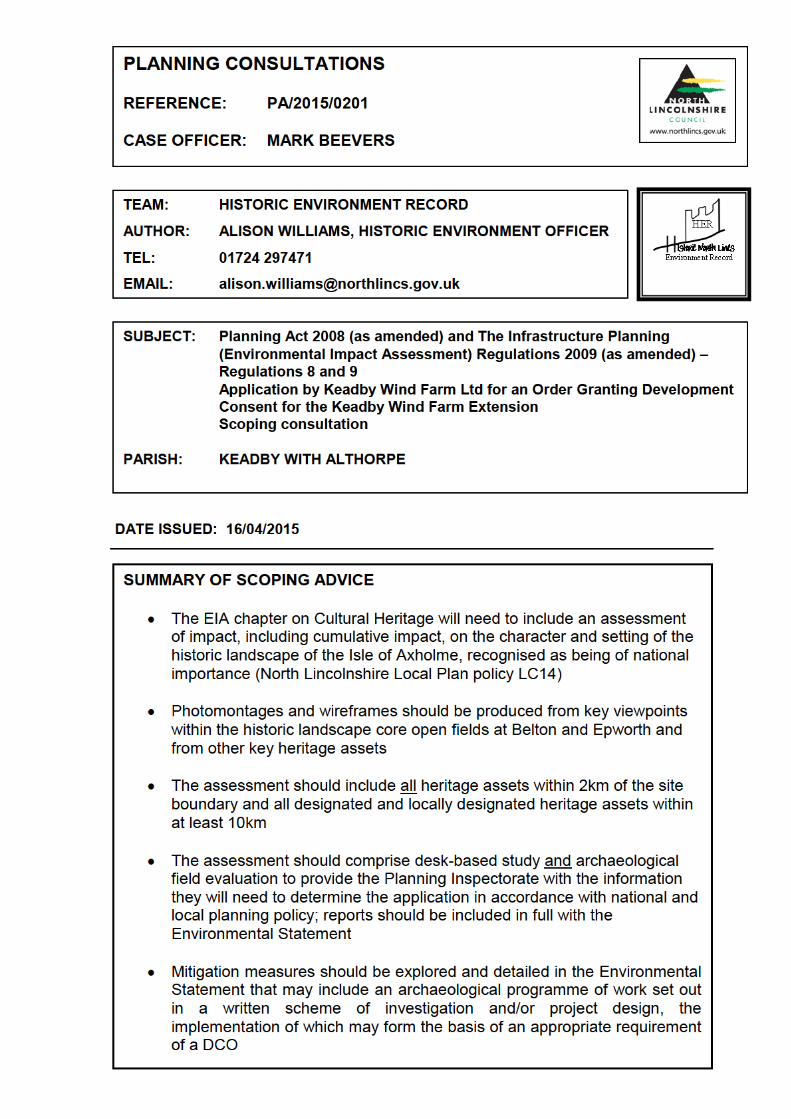
HISTORIC ENVIRONMENT RECORD (HER) GROUP FUNCTION: To hold, maintain, interpret and manage heritage information, enhancing the understanding of the area’s historical development as a distinctive and attractive place. HER information provides source material for interpretation by heritage professionals and for use by community groups and individuals. The Group also provides advice on development proposals that affect, or may affect, the sites and settings of all heritage assets i.e. designated and non-designated historic buildings, archaeological sites and monuments, and historic places, areas and landscapes. This advice is provided against saved local plan policies and national historic environment policies. DETAILED ADVICE Thank you for consulting the HER on this scoping report, section 6.6 of which sets out the proposed assessment of cultural heritage and archaeology. This memo incorporates the advice of the council’s HER officer and the Conservation Officer. Planning (Listed Building and Conservation Areas) Act 1990 Section 66 of the Planning (Listed Buildings and Conservation Areas) Act 1990 (“the Listed Buildings Act”) imposes a “General duty as respects listed buildings in exercise of planning functions.” Subsection (1) provides: ‘In considering whether to grant planning permission for development which affects a listed building or its setting, the local planning authority or, as the case may be, the Secretary of State shall have special regard to the desirability of preserving the building or its setting or any features of special architectural or historic interest which it possesses’ Planning Policy National planning policies and guidance relevant to the Historic Environment that apply to this proposal will include Overarching National Planning Statement (NPS) EN1 Part 5.8 and NPS EN3 2.7.41-45; Section 12, National Planning Policy Framework (NPPF) and Guidance (NPPG); and local planning policies Core Strategy CS6 (2011); policy 4 of the SPD Planning for Renewable Energy Development (2011); and saved Local Plan policies LC14, HE5, HE8 and HE9 (2003). Policy 128 of the NPPF states that ‘In determining applications, local planning authorities should require an applicant to describe the significance of any heritage assets affected, including any contribution made by their setting.’ and ‘Where a site on which development is proposed includes or has the potential to include heritage assets of archaeological interest, local planning authorities should require developers to submit an appropriate desk based assessment and, where necessary, a field evaluation.’ Policy 132 also states that ‘Significance can be harmed or lost through alteration or destruction of the heritage asset or development within its setting.’ The recently published NPPG section on renewable and low carbon energy confirms the need for careful assessment of all heritage assets and their settings, noting that ‘cumulative impacts require particular attention’ and, ‘As the significance of a heritage asset derives not only from its physical presence, but also from its setting, careful consideration should be given to the impact of wind turbines on such assets. Depending on their scale, design and prominence a wind turbine within the setting of a heritage asset may cause substantial harm to the significance of the asset’. The information needed to assess cumulative landscape and visual impacts of wind turbines is also set out. Local Plan Policy LC14 states that ‘The Isle of Axholme is designated as an area of Special Historic Landscape Interest. Within this area development will not be permitted which would destroy, damage or adversely affect the character, appearance or setting of the historic landscape, or any of its features.’ Core Strategy policy CS6 states that ‘The council will promote the effective management of North Lincolnshire’s historic assets through: Safeguarding the nationally significant medieval landscapes of the Isle of Axholme (notably the open strip fields and turbaries) …’ and ‘The council will seek to to protect, conserve and enhance North Lincolnshire’s historic environment as well as the character and setting of area of acknowledged importance
including historic buildings, conservation areas, listed buildings (both statutory and locally listed), registered parks and gardens, scheduled ancient monuments and archaeological remains….Development proposals should provide archaeological assessments where appropriate.’. Local plan policies HE5 and HE8 protect Listed Buildings and Scheduled Monuments and other nationally important sites from development that would adversely affect their sites or settings. And Policy HE9 Archaeological Evaluation states that ‘Planning permission will not be granted without adequate assessment of the nature, extent and significance of the remains present and the degree to which the proposed development is likely to affect them.’ Scoping Advice The Baseline Description for the Cultural Heritage (section 6.6.2) should include reference to the Isle of Axholme Special Historic Landscape. This area is locally designated for its unique historic landscape retaining the pattern of medieval open strip fields and early enclosures surrounding the villages on the Isle. The historic landscape character is clearly identified as a heritage asset in line with advice issued in the NPPF. The open fields at Belton, Epworth and Haxey, together with the early-enclosed fields, form the distinctive historic character core of the Isle of Axholme landscape. The landscape setting of the open strip fields makes a major contribution to the overall significance of this important heritage asset. The Isle of Axholme historic landscape is considered to be of national importance and the council is already concerned about the effects of wind turbine developments on the setting of the historic landscape. The EIA will therefore need to consider very carefully the potential impacts, including the cumulative impacts, on the character and setting of this nationally important historic landscape, in particular from the higher land around the settlements on the Isle. The LC14 area extends north to the Three Rivers, adjacent to the southern boundary of the wind farm extension site, and the open fields at Beltoft and Belton lie within 3km. Key views for the presentation of wireframes and photomontages should therefore include viewpoints from high points within the open fields at Belton, Epworth and High Burnham. Precise locations can be agreed with the consultant but in the meantime we would suggest the following geographical locations at Belton open field SE 7788 0700, Beltoft SE8026 0687; Ellers Field, Epworth SE7770 0495, Hollingsworth Lane, Epworth SE7865 0407 and High Burnham SE7749 0156. Policy LC14 is supported by the evidence of a detailed survey of the historic landscape character of the Isle of Axholme that should be consulted for this assessment (Miller, K. 1997 The Isle of Axholme, Historic Landscape Characterisation Project Countryside Commission, Leeds). The report and GIS data is available in the HER. The Scoping Report refers to the cultural heritage chapter of the ES and desk based assessment undertaken for the original wind farm application in 2003. In the ensuing twelve years, a considerable body of data has been added to the HER, not least from archaeological investigations carried out as part of the development of the existing wind farm. This work has demonstrated the potential for this area to contain other, as yet unknown, archaeological remains, including well-preserved organic remains within and below alluvial and peat deposits. These include features associated with the drainage of the Isle since the 17th century and with the practice of warping to increase the fertility of the soils for agriculture. Warp and alluvial deposits across this area are underlain with peat that formed between the Neolithic and Iron Age periods; buried land surfaces and archaeological remains pre-dating the formation of the peat may be preserved at greater depth. Construction of the proposed turbines and associated infrastructure including access tracks, crane hard-standings, laydown and compound areas, as well as the excavation of the cable trenching have the potential to disturb and/or destroy evidence of archaeological and palaeoenvironmental interest dating from the prehistoric and later periods. The alluvial and peat deposits have the potential to contain well-preserved archaeological remains such as those recently excavated on the existing Keadby wind farm where it proved necessary to remove the full depth of peat from within the construction footprints, thereby potentially exposing earlier prehistoric land surfaces and archaeology. The Scoping Report suggests two study areas for the assessment methodology, the inner study area comprising the extension site plus a 250m buffer zone (6.6.4). On the basis of the evidence held in
the HER this is considered to be inadequate and a minimum 2km buffer zone is advised to ensure that adequate baseline data is gathered to place the site in its archaeological context as well as to identify the presence of any current non-designated heritage assets that may be of equivalent status to a scheduled monument, the setting of which may be adversely impacted. The Scoping Report infers that the EIA for archaeological heritage assets will comprise a data gathering stage and a walkover survey only. Given the known archaeological potential of the extension site and the scale of the physical impact, we strongly advise that assessment should comprise desk-based study and archaeological field evaluation to provide the Planning Inspectorate with the information they will need to determine the application in accordance with national and local planning policy; the reports of each stage of the evaluation should be included in full with the Environmental Statement. Further advice on the content of the heritage assessment is provided below. In addition to the heritage assets of archaeological interest, there are a large number of designated heritage assets within the ZTV of the wind farm extension including scheduled monuments, conservation areas and listed buildings; the Scoping Report states that ‘Grade I and II* listed buildings are of national significance. Grade II listed buildings are of regional significance.’ Historic England (formerly English Heritage) has consistently pointed out that all listed buildings regardless of their grading are of national importance. The wind turbines proposed are of the largest on-shore scale, measuring up to 140m to the blade tip. The wind farm extension is located within flat open countryside affording wide views in particular from the higher ground on the Isle of Axholme where many of the designated heritage assets are located within and around the settlements. The proposed wind farm extension is therefore likely to be highly visible in views to, from and across these heritage assets and thus has the potential to adversely impact their settings and harm their special significance, including how that significance is experienced. Given the location of the wind farm extension surrounding the existing 34 turbines of the Keadby Wind Farm there will be cumulative impact with these and other existing turbines in the surrounding area. The Scoping Report indicates that the potential effects on designated assets of national importance within the Outer Study Area (10km) will be assessed by site inspection. In order to provide sufficient information with an application to PINs, we advise that where there is any intervisibility of the heritage assets and turbines, that wireframes and photomontages are produced to visualise the effects of the proposals on settings. At this stage, we would expect that such visualisations will be necessary for the Churches of St Oswald at Crowle and at Althorpe. Cultural Heritage Assessment Content The HER advises that a detailed heritage assessment of the development site for EIA should comprise a programme of desk based research and site assessment, including archaeological field evaluation, as set out below. A suitably qualified heritage specialist should prepare this assessment on the applicant’s behalf. It is advised that the scope and content of each stage of the assessment is agreed with the HER in advance of the assessment work commencing and should be set out in a written specification or project design to be submitted to the HER and agreed prior to commencement of work. The HER can supply generic requirements and briefs for Desk Based Assessment and Evaluation fieldwork. All work should be in accordance with the relevant Institute for Archaeologists published Standards and Guidance (http://www.archaeologists.net/) and Historic England guidelines (http://www.english-heritage.org.uk/publications/guidelines-and-standards. It is important to note that certain archaeological and other heritage impact assessments can only be, or are best undertaken at particular times of the year, for example when the land has just been ploughed or when the trees are bare. As with the ecological surveys, it is best practice to undertake the heritage surveys well in advance to ensure that adequate data is obtained for making a planning application, and that any impacts or constraints identified by assessment can be used to inform the iterative process of the design of the wind farm from the earliest stages. Desk-Based
• Desk based research to collate the current available information relating to all designated (national and local) heritage assets within 10km and non-designated heritage assets within
2km of the boundary of the application site; NB. consultation of the HER is a requirement of the NPPF (policy 128)
• The North Lincolnshire Historic Environment Record must be consulted as the primary data source for all heritage assets, designated and non-designated, including the historic landscape character, and is able to provide spatial and baseline data for the assessment http://www.northlincs.gov.uk/planning-and-environment/historic-environment-and-conservation/historic-environment-record/request-an-her-search/
• Policy LC14 is supported by the evidence of a detailed survey of the historic landscape character of the Isle of Axholme that should be consulted for this assessment (Miller, K. 1997 The Isle of Axholme, Historic Landscape Characterisation Project Countryside Commission, Leeds). The report and GIS data is available in the HER.
• Site visit to and walkover survey to identify the presence of any above or below ground archaeological remains that may be affected or any constraints on archaeological fieldwork
Assessment of Settings of Heritage Assets • Assessment of the potential effects upon all heritage assets and their settings within a radius
up to 10km from the development site that are inter-visible with the proposed development; visibility should be established through ‘viewshed’ or ‘zone of theoretical visibility’, as well as site assessment and relative visual impact. These assets will include the Listed Buildings, Scheduled Monuments, Conservation Areas and the Isle of Axholme Special Historic Landscape Area.
• Cumulative impact with existing and consented wind turbines in the study area should be assessed.
• The assessment methodology should be as set out in the English Heritage best practice guidance 'The Setting of Heritage Assets' see http://www.english-heritage.org.uk/publications/setting-heritage-assets/ and with reference to the English Heritage publication ‘Wind Energy and the Historic Environment” http://www.english-heritage.org.uk/publications/wind-energy-and-the-historic-environment/
• The assessment should include views from each heritage asset from where the development will be visible, as well as views which incorporate the development site and the heritage assets, with particular attention given to key visual receptors such as church towers or spires and the historic landscape. In this instance, the use of wireframes and photomontages from appropriate viewpoints within and across the heritage assets would be of particular use to demonstrate any effects of the proposals on settings.
• Relevant views should be obtained from public places and it may also be necessary to gain access onto private property to obtain those views that will provide for an adequate assessment.
• The location of viewpoints for the settings assessment should be agreed with the HER; key views for assessing the impact on the historic landscape character and its setting should include viewpoints from high points within the open fields. Precise locations can be agreed with the consultant but in the meantime we would suggest the following geographical locations at Belton open field SE 7788 0700, Beltoft SE8026 0687; Ellers Field, Epworth SE7770 0495, Hollingsworth Lane, Epworth SE7865 0407 and High Burnham SE7749 0156.
• Key views affecting the Grade I listed churches of St Oswald at Crowle and at Althorpe. Field Evaluation
• Field walking of the extension site to be carried out along transects set 10 metres apart to provide a minimum 20% sample of the artefacts visible on the surface of the application area, with contingency for 100% sample of visible artefacts where significant concentrations are identified; finds to be recorded to 10 metre resolution and all artefact distributions to be accurately geo-referenced to the British National Grid.
• Coring survey to inform the production of a detailed deposit model of subsurface topography. Individual cores should be extracted with a hand or mechanical auger along transects or within grids spaced at maximum 50 metre intervals with contingency for closer intervals where complex deposits are identified. The survey to be carried out in accordance with Geoarchaeology: Using Earth Sciences to Understand the Archaeological Record, English Heritage (2007)
• A programme of sampling and assessment of palaeo-environmental evidence. Samples to be collected using either open trenching or mechanical augers and sleeved cores for specialist processing and assessment of the potential for further analysis of all biological remains including pollen, diatoms and foraminifera, as well as plant, insect and molluscan remains. Radiocarbon dating of suitable deposits must be allowed for. The techniques and methods employed must adhere to those outlined in the Environmental Archaeology A Guide to the

Theory and Practice of Methods, from Sampling and Recovery to Post-excavation, English Heritage (2nd Edition, 2011)
• Geophysical survey of the application area to include as appropriate the following techniques: gradiometry (minimum 75% sample), resistivity (minimum 30% sample) and Ground Penetrating Radar (10% sample). Soil stripping in advance of geophysical survey may be required in areas where the depth of alluvial deposits may mask underlying archaeological features. Surveys must be undertaken in accordance with Geophysical survey in archaeological field evaluation, English Heritage (2008).
• Sample excavation to investigate the nature, character, extent, depth, date, state of preservation and significance of any archaeological remains within the application area; the nature and scope of the excavations will be dependent on the results of the above surveys.
Assessment of Significance and Impact
• Assessment of the significance of those heritage assets, including the Isle of Axholme Historic Landscape, likely to be directly or indirectly impacted by the development, including the contribution made by their settings
• The assessment of the significance of heritage assets should be based on the values set out in Conservation Principles, Policies and Guidance for the sustainable management of the historic environment, English Heritage, 2008 http://www.english-heritage.org.uk/publications/conservation-principles-sustainable-management-historic-environment/
• Assessment of impact of all aspects of the proposed development on the significance of the heritage assets and their settings based on the findings of the preceding stages, including reference to details of proposed construction ground works.
Mitigation Strategy
• The EIA should include detailed mitigation proposals to conserve and/or off-set any adverse effects on the historic environment that may be justified, including on the historic landscape character and its setting.
• Where important features or remains are identified, these should be preserved. The preferred option will be the physical or in situ preservation (retaining the visual amenity and landscape contribution of the site, free from adverse development eg. by relocating wind turbines and other infrastructure to avoid heritage assets and archaeological remains). The possibilities of reconciling the needs of preservation with those of the development should be fully explored, however, where in situ preservation of archaeological remains proves impracticable, preservation by record is considered to be the second-best option, through detailed excavation in advance of development, to include post-excavation analysis and publication of results.
• Programmes of archaeological recording to be set out in a detailed written scheme of investigation, including project design/specification, as an appendix to the Environmental Statement (ES).
Environmental Statement Content
• The ES should include the specialist reports of all archaeological and historic landscape assessment and survey work (as appendices where appropriate).
• All archaeological and historic landscape features should be accurately mapped and shown at an appropriate scale georeferenced to published Ordnance Survey data.
I trust this recommendation is acceptable.
From: Louisa Simpson/HT/NorthLincs
To: Mark Beevers/NorthLincs@NorthLincs
Date: Thursday, April 02, 2015 10:08AM
Subject: Fw: EN010070 – Keadby Wind Farm Extension – EIA Scoping Notification andConsultation
Mark,
There will be an impact on the highway network during the construction phase, this will beminimised through the implementation of and adherence to a Construction Phase TrafficManagement Plan and the proposals to route all traffic via the purpose built access road fromthe A18. The latter will help to minimise the impact of construction traffic on local
settlements.
It is anticipated that the impact on the highway network during the operational phase will beneglible.
The proposed assessment methodology for Traffic, Access and Transport outlined in section6.9 of the EIA Scoping Request is acceptable and should provide a robust assessment. ATransport Statement and Construction Phase Traffic Management Plan will be required tosupport any planning application.
Regards
Louisa SimpsonTransport PlannerCommunity Services
Places DirectorateNorth Lincolnshire Council
01724 297507 (Tuesday - Friday)
-----Forwarded by Louisa Simpson/HT/NorthLincs on 04/02/2015 10:06AM -----To: Louisa Simpson/HT/NorthLincs@NorthLincsFrom: Darren Cowling/HT/NorthLincsDate: 03/30/2015 04:46PM
Subject: Fw: EN010070 – Keadby Wind Farm Extension – EIA Scoping Notification andConsultation
Darren Cowling
Highway Development Services OfficerTel:- 01724 296699
-----Forwarded by Darren Cowling/HT/NorthLincs on 30/03/2015 04:46PM -----
To: Darren Cowling/HT/NorthLincs@NorthLincs, Andrew Taylor/PL/NorthLincs@NorthLincs,Alison Williams/LE/NorthLincs@NorthLincs, Pattie Rennison/NE/NorthLincs@NorthLincs,Sarah Nicholson/NE/NorthLincs@NorthLincs, Eddie Rychlak/PL/NorthLincs@NorthLincsFrom: Mark Beevers/NorthLincsDate: 30/03/2015 04:45PM
Subject: Fw: EN010070 – Keadby Wind Farm Extension – EIA Scoping Notification andConsultation
Page 1 of 3
17/04/2015http://nlcmail02.northlincs.gov.uk:81/mail/mbeevers.nsf/0a967ab30c4a51ca80257e28...
Hi All,
The Planning Inspectorate has received a Scoping Request regarding the extension ofKeadby Wind Farm. You will note that the deadline has now expired, however,correspondence received at this stage will be passed onto the applicants.
Please let me know if the contents of this report raise any concerns.
I would be grateful for a response within the next 14 days.
Thanks
Mark BeeversPrincipal Strategic Development OfficerTel: 01724 297505Mob: 07773 189545
Email: [email protected]
-----Forwarded by Mark Beevers/NorthLincs on 30/03/2015 04:37PM -----To: Mark Beevers/NorthLincs@NorthLincs
From: Planning/PL/NorthLincsSent by: Charlotte Toplass/TAS/NorthLincsDate: 25/02/2015 09:53AMSubject: Fw: EN010070 – Keadby Wind Farm Extension – EIA Scoping Notification andConsultation
For your information/ response. Our ref number is PA/2015/0201.
Regards
Charlotte
-----Forwarded by Charlotte Toplass/TAS/NorthLincs on 25/02/2015 09:53AM -----To: "[email protected]" <[email protected]>
From: Environmental Services <[email protected]>Date: 24/02/2015 11:58AMSubject: EN010070 – Keadby Wind Farm Extension – EIA Scoping Notification andConsultation
Dear Sir/Madam
Please see the following hyperlink to correspondence on the proposed Keadby WindFarm Extension.
http://infrastructure.planningportal.gov.uk/wp-content/uploads/2015/02/150224 EN010070 Letter-to-stat-cons Scoping-AND-Reg-9-Notification.pdf
Please note the deadline for consultation responses is 24 March 2015, and is astatutory requirement that cannot be extended.
Kind regards,
Richard Kent
Page 2 of 3
17/04/2015http://nlcmail02.northlincs.gov.uk:81/mail/mbeevers.nsf/0a967ab30c4a51ca80257e28...
EIA and Land Rights Advisor
Major Applications and Plans, The Planning Inspectorate, Temple Quay House, TempleQuay, Bristol, BS1 6PN
Direct Line: 0303 444 5895
Helpline: 0303 444 5000Email: [email protected]
Twitter: @PINSgovWeb: www.planningportal.gov.uk/planninginspectorate (Planning Inspectorate caseworkand appeals)Web: www.planningportal.gov.uk/infrastructure (Planning Inspectorate's National
Infrastructure Planning portal)
This communication does not constitute legal advice.
Please view our Information Charter before sending information to the PlanningInspectorate.
**********************************************************************
This email and any files transmitted with it are private and intended
solely for the use of the individual or entity to which they are
addressed. If you are not the intended recipient the E-mail and any files
have been transmitted to you in error and any copying, distribution or
other use of the information contained in them is strictly prohibited.
Nothing in this E-mail message amounts to a contractual or other legal
commitment on the part of the Government unless confirmed by a
communication signed on behalf of the Secretary of State.
The Department's computer systems may be monitored and communications
carried on them recorded, to secure the effective operation of the system
and for other lawful purposes.
Correspondents should note that all communications from Department for
Communities and Local Government may be automatically logged, monitored
and/or recorded for lawful purposes.
***************************************************************************
********
The original of this email was scanned for viruses by the Government Secure Intranetvirus scanning service supplied by Vodafone in partnership with Symantec. (CCTMCertificate Number 2009/09/0052.) This email has been certified virus free.Communications via the GSi may be automatically logged, monitored and/or recordedfor legal purposes.
Page 3 of 3
17/04/2015http://nlcmail02.northlincs.gov.uk:81/mail/mbeevers.nsf/0a967ab30c4a51ca80257e28...