Embed Size (px)
Citation preview
Singapore Journal of Tropical Geography, 21(2), 2000, 107-130 Copyright 2000 Department of Geography, National University of Singapore, and Blackwell Publishers Ltd
INTRODUCTION
Land cover change affects energy and massflows between the land surface and theatmosphere. Local and regional climatic andhydrologic change may, therefore, result fromland cover change. Decades of empiricalwatershed experiments and recent processstudies and physically-based modelingefforts suggest a range of different
hydrologic responses to reduction orreplacement of forest cover in a basin (seeBruijnzeel, 1990; forthcoming). Whileadvances have been made in understandingthe atmospheric and hydrologic effects ofland cover change, questions remainregarding the different influences of thevarious types of land cover replacing forest.
LATENT AND SENSIBLE ENERGY FLUX OVERDEFORESTED LAND SURFACES IN THE EASTERN
AMAZON AND NORTHERN THAILAND
T.W. Giambelluca1, M.A. Nullet1, A.D. Ziegler1 and L. Tran2
1Department of Geography, University of Hawai‘i at Manoa,Honolulu, USA
2Center for Integrated Regional Assessment,The Pennsylvania State University, Pennsylvania, USA
ABSTRACT
Land cover change may impact watershed hydrology and regional climate by altering land-atmosphere exchanges of energy and water. Conversion of forest to pasture has previously beenshown to decrease the rate of evaporation (including transpiration) because of reduced aerodynamicroughness, less canopy rainfall interception and greater canopy resistance during dry periods.However, less is known about the effects of forest replacement land covers other than pasture. Inthis study, field measurements of meteorological processes, stomatal resistance, and Leaf AreaIndex (LAI) were taken over various deforested land surfaces in the eastern Amazon Basin and innorthern Thailand. Based on these measurements, evaporation and sensible heat flux were estimatedover each site. Results show the degree to which different land covers replacing tropical forestaffect energy partitioning. In comparison with forest, non-irrigated, actively and recently cultivatedsites had sharply lower rates of evaporation. Secondary vegetation generally had higher rates ofevaporation than actively or recently used sites. The proportion of energy used for evaporationincreased rapidly with age in secondary vegetation. Evaporation rates at sites eight and 25 yearsafter abandonment in the Thailand study area were enhanced by positive sensible energy advectionfrom nearby cultivated areas, and were similar to those of primary forest. Differences in dryseason evaporation rates of 3-, 8- and 25-year secondary vegetation are explained, in part, by thedifferences in canopy resistance. Minimum canopy resistance was 223, 61 and 58 s m-1, respectivelyat the 3-, 8 - and 25-year sites.
Giambelluca.p65 01/07/2000, 10:00 AM3
108 Giambelluca et al.
Deforestation alters the disposition ofradiant energy by increasing surface albedoand daytime long-wave emission by thesurface, resulting in lower net radiation (e.g.Bastable et al., 1993; Culf et al., 1995;Giambelluca et al., 1997; 1999). Net radiationis partitioned primarily into latent energy flux(evaporation and transpiration) and sensibleenergy flux (heating of the lower atmosphere).The characteristics and variable state of theland surface control this partitioning process.Moist, rough surfaces generally convert alarge portion of net radiation into latent energyflux. Replacing forest with other land coversmay change the proportions of energy goinginto latent and sensible flux because ofdifferences in leaf area, aerodynamicroughness, root depth and stomatal behaviour.During and immediately following rainfall,evaporation of intercepted water is thedominant process. Reduction in canopy waterstorage capacity and air turbulence near thesurface therefore result in lower rates of wet-canopy evaporation following deforestation.For periods when the canopy is dry, mostobservations indicate that transpiration ishigher for forests than replacement landcovers, because of greater turbulencegenerated over tall vegetation, higher leaf areaof forests, and deeper root penetration of largetrees. Field studies by Jipp et al. (1998) andWright et al. (1992) found significantly lowerlatent energy flux over pasture than over forestin the Amazon. Because conversion of forestto pasture or grassland reduces evaporation1,streamflow generally increases, possiblyincreasing flood hazard. However, throughoutthe tropics, a variety of land covers other thanpasture are found in former forested areas. AsBruijnzeel (forthcoming) emphasizes, theeffects of deforestation on evaporation andstreamflow are not uniform, and depend onthe original forest type, characteristics ofreplacement land cover, climate, exposure andsoil depth.
In addition to local effects described above,land-atmosphere feedbacks may lead toregional changes in rainfall. As much as 25 to56 per cent of Amazon Basin rainfall isestimated to be derived from “recycling” ofwater evaporated within the basin (Eltahir &Bras, 1996). Basin rainfall, therefore, maydecrease if evaporation is reduced bydeforestation. A series of General CirculationModel (GCM) simulations (e.g. Nobre et al.,1991; Polcher & Laval, 1994; McGuffie et al.,1995; Henderson-Sellers et al., 1996; Xue etal., 1996) suggests that replacement of theentire Amazon rainforest with pasture couldreduce evaporation and alter atmosphericcirculation, decreasing basin rainfall by asmuch as 20 per cent.
While conversion of large tracts of tropicalforest to grassland may produce significantlocal and regional impacts on energy and waterfluxes, the consequences of more realisticscenarios of future land cover change in thetropics are less certain. It is reasonable topredict that a future deforested tropicallandscape will not be solely grassland ordegraded pasture but, instead, will be composedof a variety of replacement land covers. Forexample, much of the existing deforested areasof the Amazon and Thailand are covered withsecondary vegetation at different stages ofsuccession (Moran et al., 1994; Fox et al., 1995).The degree to which large-scale hydrologicprocesses will be affected by tropicaldeforestation depends on the physicalcharacteristics, size and shape of spatial unitscomposing the land-cover mosaic that willreplace forest. Much of the uncertainty incurrent predictions of deforestation effectsstems from a lack of information about thebehaviour of various replacement land coversand possible interaction among different landcover patches in a highly fragmentedlandscape. Prior field studies (e.g. Wright etal., 1992; Bastable et al., 1993) have improvedunderstanding of energy fluxes over pasture.However, relatively few observations havebeen made over other replacement land covers,such as secondary vegetation.
1Except where otherwise specified, “evaporation” inthis paper is equivalent to “evapotranspiration”.
Giambelluca.p65 01/07/2000, 10:00 AM4
We have previously presented estimates ofthe physical characteristics of vegetation andsoils for a variety of deforested sites, includingsecondary vegetation of different ages, in asmall eastern Amazonian farm area and near amountain village in northern Thailand(Giambelluca, 1996; Giambelluca et al., 1997;1999). In general, we found that thecharacteristics of most deforested surfacesdiffered from forest, but less so than those ofthe extreme scenarios used in most GCMdeforestation simulations (i.e. degradedpasture). In this paper, we present energy fluxestimates based on field observations at thosesame sites. We attempt to show how thevarious land covers differ in the way theypartition net radiation into sensible and latentheat flux. In particular, we look for evidence ofreduced evaporative flux from recently clearedor actively cultivated sites and for any trendin energy partitioning as secondary vegetationmatures. Our objective is to demonstrate thevariability in land-atmosphere fluxesassociated with the diverse land cover mosaicreplacing forest.
METHODOLOGYField sites at Igarapé-Açu (Brazil)and Pang Khum (Thailand)The Amazon Basin and Southeast Asia aretwo regions of major concern regarding thepossible consequences of large scale tropicaldeforestation. The regions are physically andculturally distinct. The climate of peninsularSoutheast Asia is strongly influenced by theadjacent ocean and modulated by themonsoon cycle and, therefore, less susceptibleto land-cover-change-induced atmosphericfeedbacks than the more continental Amazonregion (Henderson-Sellers et al., 1996). Forestcover in the Amazon, though decreasing at analarming rate, is much more extensive than thatof Southeast Asia, where very little “oldforest” remains. The cultural incentives andtypical forest replacement land covers alsodiffer between the two regions. The lure ofcattle ranching remains a strong inducementto clear forest in South America. In the
remaining forested areas of Southeast Asia,shifting cultivation is often identified as animportant cause of deforestation, and cattleranching is not extensive. The two studyareas, Igarapé-Açu, Pará State, Brazil and PangKhum, Chiang Mai Province, Thailand, arerepresentative of these two contrastingregions. Agricultural practices at the two siteshave in common the use of fire to prepare fieldsfor cultivation, but differ in terms of croppreferences, length of fallow and use ofirrigation.
Igarapé-Açu, Pará, Brazil is located in alowland equatorial rainforest region (Sá et al,1993). Agricultural practices in the village ofIgarapé-Açu are typical of those of small farmsin the deforested areas of the eastern AmazonBasin. Beginning in the early part of thiscentury, the tropical rainforest in areassurrounding Igarapé-Açu has been replacedby secondary vegetation, areas cleared inpreparation for planting field crops or pasturegrass. Secondary vegetation, known locallyas capoeira, grows during multi-year fallowperiods in the traditional slash-and-burncropping system of the region (Sá et al., 1993).Cassava, corn, cowpea and rice are the maincrops (Kato & Denich, 1993). The equatorialclimate of the region is characterized by a smallannual cycle of temperature averaging 26ºC.About 2,500 mm of rainfall is received annually,with the highest amounts during Februarythrough April and the minimum duringSeptember through November (Bastos et al.,1993). Soils at the site are ultisols, with loamysand texture in the topsoil and sandy clay loamtexture in the subsoil (Hölscher et al., 1997).
Pang Khum is a village located at an altitudeof 1,250 m, north of Chiang Mai in northernThailand. The site is in mountainous terrainwith a monsoonal climatic regime and naturalvegetation of lower montane forest (Hansen,1992). It was originally settled 200 years agoby the Karen ethnic hilltribe group. Duringthe past 20 years, members of Lisu ethnicgroup have settled in the village. The villagersof both groups practice swidden agriculture
Latent and Sensible Energy Flux 109
Giambelluca.p65 01/07/2000, 10:00 AM5

on the slopes surrounding the settlement (Foxet al., 1994). Paddy rice is also grown onterraced fields in the valley bottoms. Swiddencrops, which were chiefly for subsistence inthe past, now include vegetables, fruit, barleyand cut flowers for sale outside the village.The population of the village (approximately16 people km-1) as well as the surroundingregion is growing rapidly (Fox et al., 1995).The increased land pressure has reducedfallow periods and expanded the area ofcultivation at the expense of old growth forest.Rainfall has a well defined annual cycle. Therainy season extends from mid-May throughOctober, during which approximately 90 percent annual rainfall occurs. Mean annualrainfall at the site is approximately 1,100 to1,300 mm. Mid-November through lateFebruary is the cool season, with mean airtemperatures of around 17ºC. During the hotseason, March to mid-May, air temperatureaverages about 25ºC, reaching daytime highsabove 30ºC.
Instrumentation and measurementsMeteorological measurements were taken inboth Igarapé-Açu and Pang Khum using asingle set of sensors that was moved from siteto site to produce a sequence of observationsfor different covers. Data were automaticallysampled at 5-second intervals and averageswere recorded every 10 minutes. Measurementperiods varied from two to 37 days (Table 1).At each site, we measured solar radiation,reflected shortwave radiation, net radiation, soilheat conduction, canopy temperature (soilsurface temperature in the case of bare soil),air temperature, humidity and rainfall.Instrumentation and data recording equipmentare listed in Table 2. Soil heat conduction wasmeasured with a heat flux plate inserted intothe soil in a horizontal position, as close to thesoil surface as possible without exposing thesensor to radiation (typically about 2 to 3 cmbelow the surface). We measured soil heat fluxat only one point at each site, and we did notcorrect for changes in stored heat in the soilabove the sensor. Canopy temperature wasmeasured remotely using an infrared
thermometer mounted above the canopy orbare soil surface. At Pang Khum, wind wasmeasured at one or more height at each siteand temperature and humidity were measuredat more than one height at some sites. TheIgarapé-Açu field site coincides with the SHIFTProject study area (Hölscher et al., 1997). TheSHIFT meteorological tower was equipped withtemperature and humidity profiling andradiation flux sensors for estimatingevaporation via the Bowen ratio method. Thetower also included an anemometer measuringwind velocity at 3.2 m above the ground. Weadded anemometers at 2.3 m and 6.8 m to theSHIFT meteorological tower to allow analysisof the vertical wind profile. Wind velocity ateach of our Igarapé-Açu sites was estimatedby adjusting measurements taken at the SHIFTtower to a reference height above the canopyor bare soil surface at each site. We argue thatextrapolating the wind measurements in thismanner is justified in this case because of theflat terrain and close proximity of theobservation sites (all within 400 m of the SHIFTtower). Radiation, temperature and humiditysensor calibrations were adjusted on the basisof several in-field comparison runs.
In addition to continuous recording ofmeteorological observations, we operated ahand-held porometer to sample stomatalresistance and a ceptometer to measure canopylight interception at the sites with 3-, 8- and25-year secondary vegetation (i.e. Sites (p),(q) and (r) respectively in Pang Khum).Photosynthetically active radiation (PAR)measurements were taken simultaneously withthe ceptometer placed on or above the groundunder the canopy and with a quantum sensormounted above the canopy. Furtherexplanation of the field observation methodscan be found in earlier works (Giambelluca,1996; Giambelluca et al., 1996; 1997; 1999).
Observations were taken primarily duringthe driest part of the year at each site (Octoberand November 1992 in Igarapé-Açu andJanuary through May 1993 in Pang Khum).At Pang Khum measurements continued into
110 Giambelluca et al.
Giambelluca.p65 01/07/2000, 10:00 AM6

TABLE 1. OBSERVATION PERIODS FOR FIELD MEASUREMENT SITESIN BRAZIL AND THAILAND
TABLE 2. SENSORS AND DATA RECORDERS
Latent and Sensible Energy Flux 111
SITE LENGTH OF
OBSERVATION MEASUREMENT PERIOD
(days) Igarapé-Açu, Brazil
1992
(a) Slashed vegetation 8 7-14 October (b) Burned slash 2 5-7 November (c) Bare soil 2 7-9 November (d) Mature cassava 2 14-16 October (e) Unused pasture 2 28-30 October (f) ½ yr Secondary vegetation 2 21-23 October (g) 1-yr Secondary vegetation 2 16-19 October (h) 1-yr Secondary vegetation 3 19-21October (i) 2-yr Secondary vegetation 3 23-26 October (j) 2-yr Secondary vegetation 2 26-28 October (k) 10-yr Secondary vegetation 5 30 October-5 November
Pang Khum, Thailand 1993
(l) Harvested barley 8 13-21 March (m) Fallow rice paddy 15 26 April-11 May (n) Irrigated bare soil 6 24-30 March (o) 2-yr Secondary vegetation 6 7-13 March (p) 3-yr Secondary vegetation 9 30 March-8 April (q) 8-yr Secondary vegetation 37 24 January-2 March (r) 25-yr Secondary vegetation
25
9-21 April and 11-24 May
INSTRUMENT
COMPANY
LOCATION
MODEL
Shortwave radiation
Downward Eppley Laboratory Newport, RI 8-48 Reflected Eppley Laboratory Newport, RI PSP
Net all-wave radiation REBS Seattle, WA Q*6 Soil heat conduction REBS Seattle, WA HFT-1 Canopy temperature Everest Interscience Fullerton, CA 4000ALCS Air temperature/Relative humidity Vaisala Helsinki, Finland HMD30UYB Rainfall Campbell Sceintific Logan, UT TE525 Data loggers Licor Lincoln, NE LI-1000 Porometer Delta-T Cambridge, England AP4 Photosynthetically active radiation (PAR) Decagon Pullman, WA Quantum sensor Below-canopy PAR
Decagon
Pullman, WA
CEP
Note: RI: Rhode Island; WA: Washington; CA: California; UT: Utah; NE: Nebraska.
Giambelluca.p65 01/07/2000, 10:00 AM7
the first several weeks of the rainy season,beginning in May. Rainfall measurementscontinued until August. Characteristics ofeach measurement site are given in Table 3.Figures 1 and 2 provide maps showing thelocations of measurement sites. The Brazil sitereferred to as “Slashed vegetation” was a fieldwhere 7-year secondary vegetation hadrecently been cut. The slashed vegetationremained on the ground at the time of theobservations. Later, after the vegetation haddried for several weeks, the field was burned.Measurements at the same site after the burnare listed under “Burned slash”. Table 4 givesthe mean vegetation height and sensor heightsat each site. Because land cover patches aresmall in the two study areas, upwind fetch atsome sites was less than optimal. We placedthe instruments as close as possible to thecanopy (or ground in the case of bare soil) inorder to minimise fetch-related errors, but notso low as to be affected by individualobstacles. We believe fetch distances at oursites to be adequate under the very low windspeed conditions experienced throughoutmost of the observation periods.
Energy partitioningNet radiation, i.e. radiant energy absorbedminus that emitted, is partitioned into sensibleand latent energy fluxes to the atmosphere andchanges in sensible energy storage in theabove-ground biomass and the soil.Neglecting energy storage in the above-ground biomass, we can represent the surfaceenergy balance with the simple expression:
(1)where Rn = net radiation [W m-2], λ = latentheat of vaporization [28.36 W m-2 (mm d-1) -1],E = evaporation [mm d-1], G = soil heatconduction defined as positive downwards[W m-2], and H = sensible energy flux [W m-2].H can be estimated as (Monteith, 1973):
(2)where ρ = the air density [kg m-3], Cp = specificheat of air at constant pressure [J kg-1 K-1], Tc= canopy temperature [K] Ta = air temperature[K], and rac = stability corrected aerodynamic
resistance [s m-1]. For neutral stability,aerodynamic resistance to water vapourdiffusion [s m-1] can be estimated as (Brutsaert& Stricker, 1979):
(3)
where zo = roughness length for momentumtransfer [m], z0h = roughness length forsensible and latent heat transfer [m], za = windmeasurement height [m], and d = zero planedisplacement height [m], k = von Karmanconstant (0.41), and u = wind velocity. Fornon-neutral conditions, corrections suggestedby Pruitt et al. (1973) are applied.
Roughness length for momentum transfer(z0) in Equation 3 can be estimated using windprofile measurements:
(4)
where u1 and u2 = wind velocities [m s-1] atheights [m] zu1 and zu2. We used Equation 4 toestimate aerodynamic parameters z0 for the fivesites with wind measurements at two or morelevels. Only data from periods of neutralstability (Richardson Number between + 0.01;see Oke (1987:380-83)) were used in theanalysis. Those results were found to conformvery well to the empirical relationshipsbetween z0 and vegetation height (h) .Equations given by Rosenberg et al. (1983)were used to estimate z0 and d at other sites asa function of h or the estimated height ofroughness elements for bare soil.
The relationship between roughness lengthfor sensible and latent heat transfer (z0h) and z0may be approximated as:
(5)
where the parameter B-1 depends on thecharacteristics of the vegetation. Brutsaert(1982:105) summarises experimental results thatsuggest values of B-1 for several vegetationtypes. We set B-1 = 2.3 for all sites.
( )ac
acp
rTTCH −= ρ
ukz
dzz
dz
r 20h
a
0
a
a
−
−
=lnln
−−−−=
12
u21u12
uudzudzuz )]ln()ln([exp0
1
0h
0 Bzz −=ln
112 Giambelluca et al.
GHλERn ++=
Giambelluca.p65 01/07/2000, 10:00 AM8
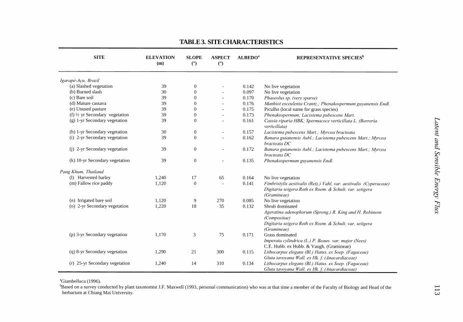
TABLE 3. SITE CHARACTERISTICS
Latent and Sensible Energy Flux 113
SITE
ELEVATION
SLOPE
ASPECT
ALBEDOa
REPRESENTATIVE SPECIESb (m) (°)
(°)
Igarapé-Açu, Brazil
(a) Slashed vegetation 39 0 - 0.142 No live vegetation (b) Burned slash 30 0 - 0.097 No live vegetation (c) Bare soil 39 0 - 0.170 Phaseolus sp. (very sparse) (d) Mature cassava 39 0 - 0.176 Manhiot esceulenta Crantz.; Phenakospermum guyanensis Endl. (e) Unused pasture 39 0 - 0.175 Piculho (local name for grass species) (f) ½ yr Secondary vegetation 39 0 - 0.173 Phenakospermum; Lacistema pubescens Mart. (g) 1-yr Secondary vegetation 39 0 - 0.161 Cassia riparia HBK; Spermacoce verticillata L. (Borreria
verticillata) (h) 1-yr Secondary vegetation 30 0 - 0.157 Lacistema pubescens Mart.; Myrcea bracteata (i) 2-yr Secondary vegetation 39 0 - 0.162 Banara guianensis Aubl.; Lacistema pubescens Mart.; Myrcea
bracteata DC (j) 2-yr Secondary vegetation 39 0 - 0.172 Banara guianensis Aubl.; Lacistema pubescens Mart.; Myrcea
bracteata DC (k) 10-yr Secondary vegetation 39 0 - 0.135 Phenakospermum guyanensis Endl.
Pang Khum, Thailand (l) Harvested barley 1,240 17 65 0.164 No live vegetation (m) Fallow rice paddy 1,120 0 - 0.141 Fimbristylis aestivalis (Retz.) Vahl. var. aestivalis (Cyperaceae) Digitaria seigera Roth ex Roem. & Schult. var. setigera
(Gramineae) (n) Irrigated bare soil 1,120 9 270 0.085 No live vegetation (o) 2-yr Secondary vegetation 1,220 18 35 0.132 Shrub dominated Ageratina adenophorum (Spreng.) R. King and H. Robinson
(Compositae) Digitaria seigera Roth ex Roem. & Schult. var. setigera
(Gramineae) (p) 3-yr Secondary vegetation 1,170 3 75 0.171 Grass dominated Imperata cylindrica (L.) P. Beauv. var. major (Nees) C.E. Hubb. ex Hubb. & Vaugh. (Gramineae) (q) 8-yr Secondary vegetation 1,290 21 300 0.115 Lithocarpus elegans (Bl.) Hatus. ex Soep. (Fagaceae) Gluta tavoyana Wall. ex Hk. f. (Anacardiaceae) (r) 25-yr Secondary vegetation 1,240 14 310 0.134 Lithocarpus elegans (Bl.) Hatus. ex Soep. (Fagaceae) Gluta tavoyana Wall. ex Hk. f. (Anacardiaceae)
aGiambelluca (1996). bBased on a survey conducted by plant taxonomist J.F. Maxwell (1993, personal communication) who was at that time a member of the Faculty of Biology and Head of the
herbarium at Chiang Mai University.
Giam
belluca.p6501/07/2000, 10:00 A
M9
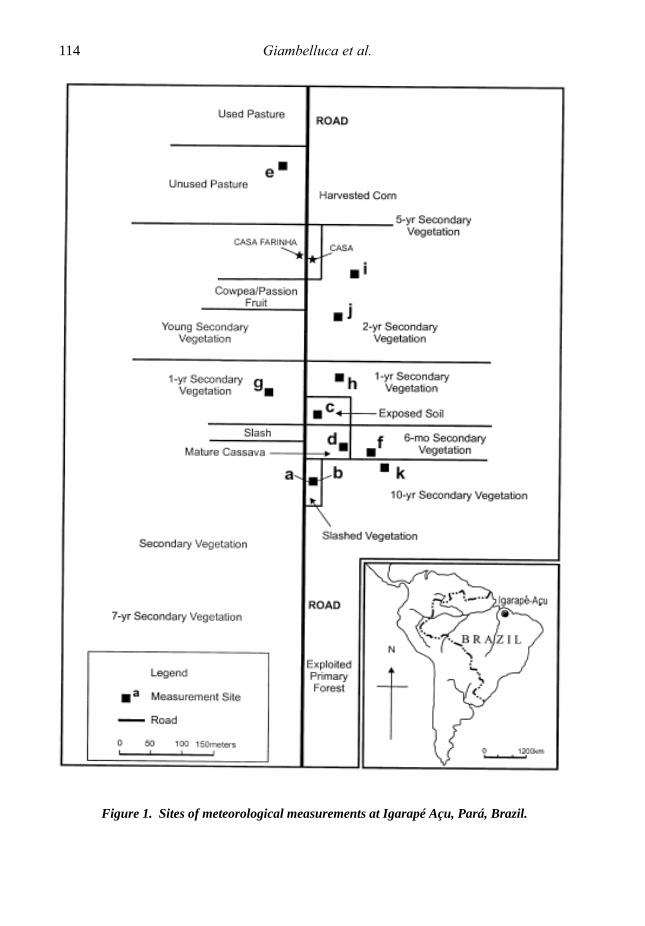
Figure 1. Sites of meteorological measurements at Igarapé Açu, Pará, Brazil.
114 Giambelluca et al.
Giambelluca.p65 01/07/2000, 10:00 AM10

Figure 2. Sites of meteorological measurements at Pang Khum, Chiang Mai, Thailand.
Latent and Sensible Energy Flux 115
Giambelluca.p65 01/07/2000, 10:00 AM11
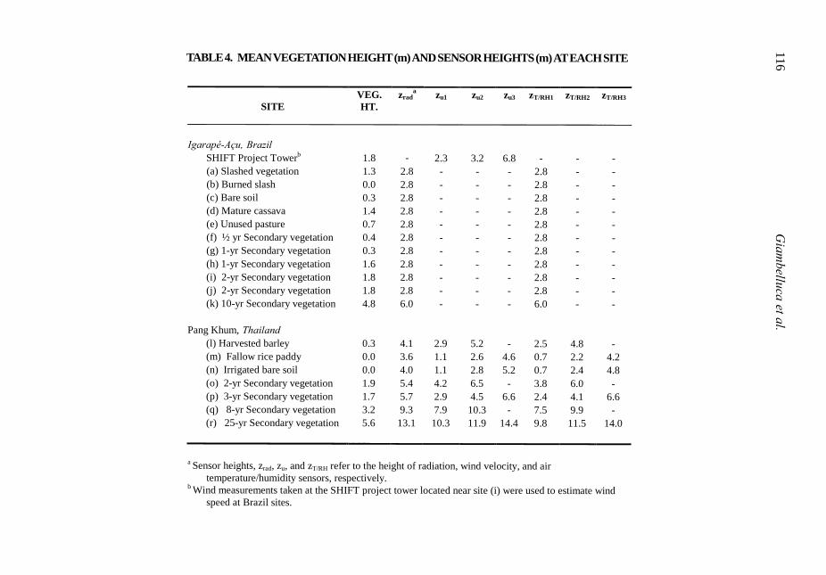
TABLE 4. MEAN VEGETATION HEIGHT (m) AND SENSOR HEIGHTS (m) AT EACH SITE116 G
iambelluca et al.
SITE
VEG. HT.
zrada
zu1
zu2
zu3
zT/RH1
zT/RH2
zT/RH3
Igarapé-Açu, Brazil SHIFT Project Towerb 1.8 - 2.3 3.2 6.8 - - -
(a) Slashed vegetation 1.3 2.8 - - - 2.8 - - (b) Burned slash 0.0 2.8 - - - 2.8 - - (c) Bare soil 0.3 2.8 - - - 2.8 - - (d) Mature cassava 1.4 2.8 - - - 2.8 - - (e) Unused pasture 0.7 2.8 - - - 2.8 - - (f) ½ yr Secondary vegetation 0.4 2.8 - - - 2.8 - - (g) 1-yr Secondary vegetation 0.3 2.8 - - - 2.8 - - (h) 1-yr Secondary vegetation 1.6 2.8 - - - 2.8 - - (i) 2-yr Secondary vegetation 1.8 2.8 - - - 2.8 - - (j) 2-yr Secondary vegetation 1.8 2.8 - - - 2.8 - - (k) 10-yr Secondary vegetation 4.8 6.0 - - - 6.0 - -
Pang Khum, Thailand
(l) Harvested barley 0.3 4.1 2.9 5.2 - 2.5 4.8 - (m) Fallow rice paddy 0.0 3.6 1.1 2.6 4.6 0.7 2.2 4.2 (n) Irrigated bare soil 0.0 4.0 1.1 2.8 5.2 0.7 2.4 4.8 (o) 2-yr Secondary vegetation 1.9 5.4 4.2 6.5 - 3.8 6.0 - (p) 3-yr Secondary vegetation 1.7 5.7 2.9 4.5 6.6 2.4 4.1 6.6 (q) 8-yr Secondary vegetation 3.2 9.3 7.9 10.3 - 7.5 9.9 - (r) 25-yr Secondary vegetation 5.6 13.1 10.3 11.9 14.4 9.8 11.5 14.0
a Sensor heights, zrad, zu, and zT/RH refer to the height of radiation, wind velocity, and air
temperature/humidity sensors, respectively. b Wind measurements taken at the SHIFT project tower located near site (i) were used to estimate wind
speed at Brazil sites.
Giam
belluca.p6501/07/2000, 10:00 A
M12

Sugita and Brutsaert (1996) showed thatwhen canopy temperature is measured with anadir-pointing infrared thermometer, z0h isstrongly dependent on sun angle, becauseof temperature differences among differentlayers of the canopy. However, thisdependence is minimised by pointing thesensor obliquely to properly weight thetemperature of the upper layers of the canopy;they suggest an angle of 60º from nadir. Inour field observations, done prior to theSugita and Brutsaert (1996) paper, the sensorwas pointed at an angle of approximately 45ºfrom nadir, toward the north, in order toreduce error associated with reflected solarradiation. This angle also gives an estimateof canopy temperature such that z0h is closeto that for an isothermal canopy, with only aminimal dependence on sun angle (Sugita&Brutsaert,1996). We did not adjust z0h forsun angle in our calculations.
Using measurements of Rn, G, Tc, estimatesof d (based on vegetation height), and verticalprofiles of Ta and u, we estimated sensibleheat flux (H) using Equation 2 and latentenergy flux (evaporation) by rearrangingEquation 1 as:
(6)
Estimation of latent energy flux as aresidual (Equation 6) means that errors inmeasurement of Rn and G, and estimate of Hwill accumulate in λE. More preciseestimation of turbulent energy fluxcomponents is possible using othertechniques, such as eddy correlation orBowen ratio. We have found the energybalance approach used here to be highlycorrelated with Bowen ratio estimates (r2 =0.85 for hourly measurements). The instru-mentation required is much less expensiveand more easily moved from site to site than,for example, a Bowen ratio set up. Energyflux estimates here have greater uncertaintythan those based on these other techniques.However, we believe the results aresufficiently accurate to permit comparisonamong different land covers.
Canopy resistanceStomatal resistance varies temporally inresponse to changes in light, leaf temperature,leaf water potential, vapour pressure deficit andwater availability in the root zone. When therate of plant water loss is higher than the rate ofintake, plants experience increasing water stressand stomata close partially or completely,thereby increasing stomatal resistance.Stomatal response to water stress is dependenton species physiology and the history of plantwater availability which changes throughout alife cycle. Canopy resistance is a variabledescribing the aggregated effect of stomatalresistance on the evaporation rate of the stand.The role of canopy resistance in regulatingevaporation from a vegetated surface isdescribed by the Penman-Monteith equation(Monteith, 1965):
(7)
where ∆ = the slope of the saturation vapourpressure versus temperature curve [mb K-1], es= the saturation vapour pressure [mb], e = theambient vapour pressure [mb], γ = thepsychrometric constant [mb K-1], and rc = thecanopy resistance [s m-1].
To estimate canopy resistance, we tookstomatal resistance measurements at three sitesin Thailand (3-, 8- and 25-year secondaryvegetation); in total, 221, 178 and 443 stomatalresistance samples were taken respectively atthese three sites. Measurements were takenfor a variety of representative species, atdifferent levels within the canopy, over thecourse of one or more diurnal cycles at eachsite. Sampling was done between late Marchand early May, prior to the onset of heavyrainfall. Samples were taken for five, six andeight species respectively at the three sites, andat three or more vertical levels within the canopyof each plant.
Canopy resistance can be calculated as theaggregate of stomatal resistances of all species
HGRE n −−=λ
( ) ( )
++∆
−+−∆=
a
ca
sa
pn
rrr
eerCGR
Eγ
ρ
λ
Latent and Sensible Energy Flux 117
Giambelluca.p65 01/07/2000, 10:00 AM13
at a given site. Because leaves in the upperpart of the canopy are more exposed to netradiation, they exert a disproportionately greatinfluence on the overall transpiration rate.Hence, in computing canopy resistance,greater weight should be given to stomatalresistance in more exposed parts of the canopy.In this study, we estimated canopy resistanceat the three Pang Khum sites by weightingleaf stomatal resistance measurementsaccording to the leaf area and relative netradiation in each layer as:
(8)
where rc = canopy resistance, = averagestomatal resistance, LAI = leaf area index (ratioof leaf area to projected ground area), Rn = netradiation, and the subscripts 1, 2 and i refer tothe uppermost, second and ith layers ofvegetation respectively. Light extinction wasused to estimate the leaf area above theceptometer. We estimated LAI at variouslevels within the canopy (corresponding tothe layers in which stomatal resistancemeasurements were taken) at each site.Estimates were derived from measurements ofcanopy light extinction using the relationshipsuggested by the ceptometer operator’smanual (Decagon Devices, 1993).
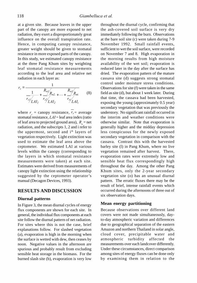
RESULTS AND DISCUSSIONDiurnal patternsIn Figure 3, the mean diurnal cycles of energyflux components are shown for each site. Ingeneral, the individual flux components at eachsite follow the diurnal pattern of net radiation.For sites where this is not the case, briefexplanations follow. For slashed vegetation(a), evaporation is high in the morning whenthe surface is wetted with dew, then ceases bynoon. Negative values in the afternoon arespurious and probably result from excludingsensible heat storage in the biomass. For theburned slash site (b), evaporation is very low
throughout the diurnal cycle, confirming thatthe ash-covered soil surface is very dryimmediately following the burn. Observationsat the bare soil site (c) were taken during 7-9November 1992. Small rainfall events,sufficient to wet the soil surface, were recordedon November 7 and 8. High evaporation inthe morning results from high moistureavailability of the wet soil; evaporation isreduced later in the day after the surface hasdried. The evaporation pattern of the maturecassava site (d) suggests strong stomatalcontrol under moisture stress conditions.Observations for site (f) were taken in the samefield as site (d), but about 1 week later. Duringthat time, the cassava had been harvested,exposing the young (approximately 0.5 year)secondary vegetation that was previously theunderstory. No significant rainfall occurred inthe interim and weather conditions wereotherwise similar. Note that evaporation isgenerally higher and the midday depressionless conspicuous for the newly exposedsecondary vegetation in comparison with thecassava. Contrast this with the harvestedbarley site (l) in Pang Khum, where no livevegetation remained after harvest. There,evaporation rates were extremely low andsensible heat flux correspondingly highthroughout the day. Among the other PangKhum sites, only the 2-year secondaryvegetation site (o) has an unusual diurnalpattern. The erratic fluxes there may be theresult of brief, intense rainfall events whichoccurred during the afternoons of three out ofsix observation days.
Mean energy partitioningBecause observations over different landcovers were not made simultaneously, day-to-day atmospheric variation and differencesdue to geographical separation of the easternAmazon and northern Thailand in solar angle,cloud cover, precipitable water andatmospheric turbidity affected themeasurements over each landcover differently.Under these circumstances, direct comparisonamong sites of energy fluxes can be done onlyby examining them in relation to the
isi
nin1
2s2
n2n1
1s1
c
LAIr
RR
LAIr
RR
LAIr
r
+++
=
L1
1
sr
118 Giambelluca et al.
Giambelluca.p65 01/07/2000, 10:00 AM14
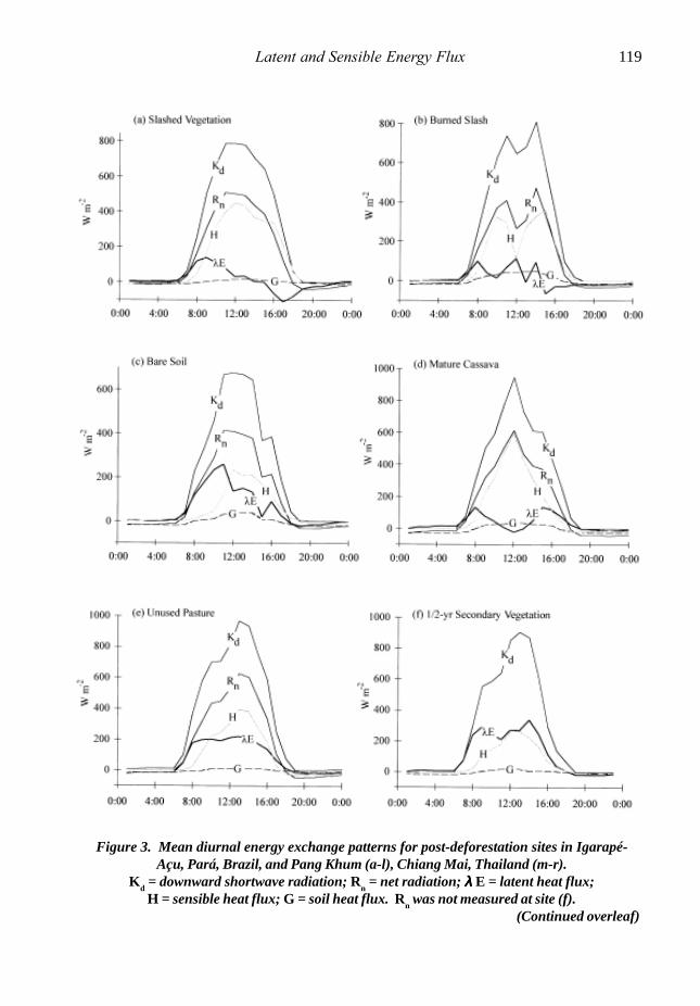
Figure 3. Mean diurnal energy exchange patterns for post-deforestation sites in Igarapé-Açu, Pará, Brazil, and Pang Khum (a-l), Chiang Mai, Thailand (m-r).
Kd = downward shortwave radiation; Rn = net radiation; λ λ λ λ λ E = latent heat flux;H = sensible heat flux; G = soil heat flux. Rn was not measured at site (f).
(Continued overleaf)
Latent and Sensible Energy Flux 119
Giambelluca.p65 01/07/2000, 10:00 AM15

Figure 3 (continued)
120 Giambelluca et al.
Giambelluca.p65 01/07/2000, 10:00 AM16
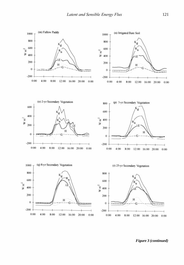
Figure 3 (continued)
Latent and Sensible Energy Flux 121
Giambelluca.p65 01/07/2000, 10:00 AM17

corresponding incoming solar radiation, or interms of the fraction of net radiation.
Field data show that recently disturbed sitesare very different in terms of energypartitioning than deforested landscapes thathave matured over time since disturbance(Table 5). For example, soil heat flux (G) duringthe daytime accounts for a much lower fractionof net radiation for advancing secondaryvegetation sites than for more recentlydisturbed sites. This effect is clearly seen inthe contrast in daytime G values foragricultural versus secondary vegetation sitesin Thailand.
Results clearly distinguish among landcovers on the basis of E versus Hpartitioning. Agricultural sites can beclassified into three groups: slash and burnsites, non-irrigated swidden sites, andirrigated sites (Figure 4a). Not surprisingly,
the evaporative fraction (λE/Rn) is extremelylow (and hence the sensible heat fractionlarge) for slash and burned slash.Evaporative fractions were moderately lowfor non-irrigated swidden sites and high forirrigated sites. Secondary vegetation sitescan also be placed into three groups on thebasis of age: 0-1 year, 2-3 years and 8-25 years(Figure 4b). These observations verify thatthe evaporative fraction of secondaryvegetation is low initially, but increasesrapidly with age.
Comparison with other forested anddeforested sitesNumerous other field studies have beendone of energy flux over tropical forest andpasture. Table 6 shows the evaporationestimates of some of those studies incomparison with our estimates. For tropicalrainforest, average annual λE is typicallyaround 100-110 W m-2, with λE/Rn of up to
Figure 4. Mean evaporative fractions (λ λ λ λ λ E/Rn) for (a) agricultural, and (b) secondaryvegetation sites in Igarapé-Açu, Pará, Brazil, and Pang Khum, Chiang Mai, Thailand.
Vertical bars show + 0.5 standard deviations about the mean.Sample size for each category is shown in parentheses next to the axis label.
122 Giambelluca et al.
Giambelluca.p65 01/07/2000, 10:00 AM18

TABLE 5. MEAN ENERGY FLUXES
Latent and Sensible Energy Flux 123
SITE Kd
a (W m-2) Rn (W m-2) G (W m-2) G/Rn λE (W m-2) λE/Rn H (W m-2) H/Rn
Dayb All Day All Day All Day All Day All Day All Day All Day All Igarapé-Açu, Brazil
(a) Slashed vegetation 463 251 272 137 7 0 0.03 0.00 25 11 0.09 0.08 240 126 0.88 0.92 (b) Burned slash 409 221 216 106 21 5 0.10 0.05 26 10 0.12 0.09 169 91 0.78 0.86 (c) Bare soil 361 195 208 102 9 -3 0.04 -0.03 106 55 0.51 0.54 93 50 0.45 0.49 (d) Mature cassava 453 245 278 136 12 -4 0.04 -0.03 54 29 0.19 0.21 212 111 0.76 0.82 (e) Unused pasture 526 288 313 157 5 -1 0.02 -0.01 142 73 0.45 0.46 166 85 0.53 0.54 (f) 1/2 yr secondary vegetation 453 245 300c 156c 5 2 0.02 0.01 182 95 0.61 0.61 113 59 0.38 0.38 (g) 1-yr secondary vegetation 452 245 268 128 26 3 0.10 0.02 140 71 0.52 0.55 102 54 0.38 0.42 (h) 1-yr secondary vegetation 489 264 308 154 8 2 0.03 0.01 180 88 0.58 0.57 120 64 0.39 0.42 (i) 2-yr secondary vegetation 397 218 243 114 2 -4 0.01 -0.04 167 88 0.69 0.77 74 30 0.30 0.26 (j) 2-yr secondary vegetation 409 225 238 119 2 -5 0.01 -0.04 189 103 0.79 0.87 47 21 0.20 0.18 (k) 10-yr secondary vegetation 422 228 273 134 2 0 0.01 0.00 145 75 0.53 0.56 126 59 0.46 0.44
Pang Khum, Thailand
(l) Harvested barley 457 248 279 123 18 6 0.06 0.05 68 21 0.24 0.17 193 96 0.69 0.78 (m) Fallow rice paddy 450 245 254 124 27 1 0.11 0.01 171 93 0.67 0.75 56 30 0.22 0.24 (n) Irrigated bare soil 448 243 330 158 31 5 0.09 0.03 266 171 0.81 1.08 33 -18 0.10 -0.11 (o) 2-yr secondary vegetation 252 137 176 82 2 0 0.01 0.00 155 90 0.88 1.10 19 -8 0.11 -0.10 (p) 3-yr secondary vegetation 392 213 233 98 10 4 0.04 0.04 144 80 0.62 0.82 79 14 0.34 0.14 (q) 8-yr secondary vegetation 454 246 320 137 0 -3 0.00 -0.02 313 158 0.98 1.15 7 -18 0.02 -0.13 (r) 25-yr secondary vegetation 413 225 285 141 2 0 0.01 0.00 274 168 0.96 1.19 9 -27 0.03 -0.19
aKd = downward shortwave radiation; Rn = net radiation; G = soil heat flux (positive downward) λΕ = latent heat flux; H = sensible heat flux to the atmosphere. bDay refers to 12-hour period 6:00-18:00. cNet radiation at site (f) estimated from solar radiation measurements.
Giam
belluca.p6501/07/2000, 10:00 A
M19
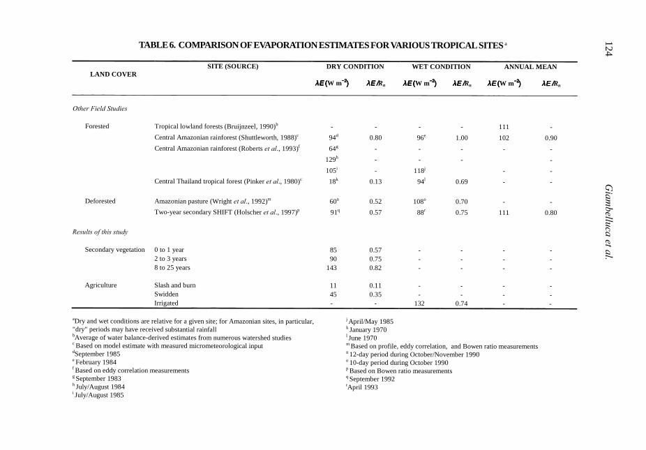
TABLE 6. COMPARISON OF EVAPORATION ESTIMATES FOR VARIOUS TROPICAL SITES a124 G
iambelluca et al.
LAND COVER SITE (SOURCE) DRY CONDITION
WET CONDITION
ANNUAL MEAN
λΕ λΕ λΕ λΕ ((((W m−2−2−2−2))))
λΕ /λΕ /λΕ /λΕ /Rn
λΕ λΕ λΕ λΕ ((((W m−2−2−2−2))))
λΕ /λΕ /λΕ /λΕ /Rn
λΕ λΕ λΕ λΕ ((((W m−2−2−2−2))))
λΕ /λΕ /λΕ /λΕ /Rn
Other Field Studies
Forested Tropical lowland forests (Bruijnzeel, 1990)b - - - - 111 - Central Amazonian rainforest (Shuttleworth, 1988)c 94d 0.80 96e 1.00 102 0.90 Central Amazonian rainforest (Roberts et al., 1993)f 64g - - - - - 129h - - - - 105i - 118j - - Central Thailand tropical forest (Pinker et al., 1980)c 18k 0.13 94l 0.69 - - Deforested Amazonian pasture (Wright et al., 1992)m 60n 0.52 108o 0.70 - -
Two-year secondary SHIFT (Holscher et al., 1997)p 91q 0.57 88r 0.75 111 0.80 Results of this study
Secondary vegetation 0 to 1 year 85 0.57 - - - - 2 to 3 years 90 0.75 - - - - 8 to 25 years 143 0.82 - - - - Agriculture Slash and burn 11 0.11 - - - -
Swidden 45 0.35 - - - - Irrigated - - 132 0.74 - -
aDry and wet conditions are relative for a given site; for Amazonian sites, in particular, "dry" periods may have received substantial rainfall
bAverage of water balance-derived estimates from numerous watershed studies c Based on model estimate with measured micrometeorological input dSeptember 1985 e February 1984 f Based on eddy correlation measurements g September 1983 h July/August 1984 i July/August 1985
j April/May 1985
k January 1970 l June 1970 m Based on profile, eddy correlation, and Bowen ratio measurements n 12-day period during October/November 1990 o 10-day period during October 1990 p Based on Bowen ratio measurements q September 1992 rApril 1993
Giam
belluca.p6501/07/2000, 10:00 A
M20
0.90. In contrast, forest in central Thailandshowed a marked annual cycle in evaporationassociated with monsoon-related changesin moisture availability (Pinker et al., 1980);λE/Rn ranged from 0.13 (dry season) to 0.69(wet season). For Amazonian pasture (Wrightet al., 1992) and young secondary vegetation(Hölscher et al., 1997), λE/Rn was lower thanthat of forest, particularly during dry periods.
Note that the SHIFT project (Hölscher etal., 1997), which used an independentlymeasured Bowen ratio data set for the sameIgarapé-Açu study site, estimatedevaporation to be 4.5 mm d-1, equivalent to128 W m-2 or λE/Rn = 0.81, for October 1992.Sites (i) and (j) were located 11 m and 60 mfrom the SHIFT meteorological tower,respectively, in the same stand of 2-yearsecondary vegetation. For 23-26 October atsite (i), λE was 88 W m-2, and for 26-28October at site (j), λ E was 103 W m-2. λ E/Rnwas 0.77 and 0.87, respectively for the twosites. Hölscher et al. (1997) estimated theannual evaporation at that site to be 3.9mm d-1 (111 W m-2), or λE/Rn = 0.80.
Other studies suggest that for dry seasonconditions, λE/Rn is about 0.8 for tropicalforest and 0.5 for pasture (Table 6). Ourresults confirm low dry season evaporationrates for recently cleared sites, but indicatethat the evaporative fraction begins toincrease soon after secondary vegetation isallowed to grow. On average for oursecondary vegetation sites in Igarapé-Açuand Pang Khum, λE/Rn had recovered to 0.75within two to three years. For three oldersecondary vegetation (8-25 years) we foundthe evaporative fraction to average 0.82,very close to the forest value, but with somenotable variation among sites discussedbelow.
Among the three advanced secondaryvegetation sites, daytime λE/Rn was only 0.53at the 10-year site at Igarapé-Açu (site k),but was very high (0.96 and 0.98) at the twoPang Khum sites (q and r). This difference
may be explained by differences invegetation type and climate regime. Sá etal. (1993) stated that the 10-year site atIgarapé-Açu was not representative of allsecondary vegetation sites of this age in thestudy region because of the exceptionaldominance of Phenakospermumguyanensis. This species has very largebanana-like leaves, which intercept and storerainfall effectively, allowing a relatively lowfraction of rain water to reach the soil (Sá etal., 1993). As a result of high interceptionevaporation during rainy periods, this sitemay have somewhat reduced soil moisturestorage at the start of dry periods and exhibitwater stress sooner than other sites. Indeed,soil moisture, leaf water potential andstomatal resistance measurements at the site,all indicated greater water stress than atneighboring sites (Sá et al., 1993). At thetwo Pang Khum sites, on the other hand,vegetation was dominated by tree speciestypical of undisturbed forest, such asLithocarpus elegans, which do not haveexceptional rainfall interceptioncharacteristics. Regarding the climateregime, Pang Khum normally experiences asix-month period of almost no rainfall; incontrast Igarapé-Açu has a shorter, lessintense dry season. At the time of ourmeasurements in Pang Khum, swidden fields(e.g. the harvested barley site) wereextremely dry. In the highly fragmentedlandscape, these patches became sourcesof sensible heat which was advected toneighboring stands of deeply-rooted trees,which in turn exhibited higher rates ofevaporation. Based on these observations,we believe that as long as sufficient soilwater is available, dry-season evaporationwithin patches of advanced secondaryvegetation and forest will be very high, evenexceeding net radiation (we found λE/Rn of1.15 and 1.19 for sites q and r). Youngersecondary vegetation at Pang Khum, suchas site (p), with correspondingly shallowerroots, experiences water stress during thedry season and evaporation is reduced byincreased stomatal resistance. In the
Latent and Sensible Energy Flux 125
Giambelluca.p65 01/07/2000, 10:00 AM21

following section, we give the results ofmeasurements showing higher stomatalresistance in younger secondary vegetationas evidence of the effects of moisture stress.
Canopy resistenceSite-specific canopy resistances calculatedfrom the stomatal resistance and LAI data(Equation 8) are very informative of theinfluences of different land cover onevapotranspiration. Figure 5 shows thatcanopy resistances of 8- and 25-yearsecondary vegetation (sites q and r) are verysimilar to each other, while that of the 3-yearsecondary vegetation site (p) is much higherthroughout the diurnal cycle. Holding all othervariables constant at typical values, thedifference in canopy resistance shown impliesa reduction in evaporation of about 50 per centbased on the Penman-Monteith model(Equation 7). This is consistent with ourenergy balance measurements and verifies thatevaporation at more mature secondaryvegetation sites is significantly higher than
that at sites abandoned for only a few years.Minimum canopy resistance was 223, 61, and58 s m-1, respectively at the 3-, 8- and 25-yearsites respectively. In comparison, minimumcanopy resistance is typically set at 140 and 32s m-1 (Xue et al., 1996), respectively, for grass-covered and forested land, representing thecontrasting scenarios in GCM deforestationexperiments.
CONCLUSIONS
Regional climatic and hydrologic change hasbeen predicted to result from tropicaldeforestation due, in part, to large changes inthe way absorbed radiant energy is partitionedinto latent and sensible heat fluxes to theatmosphere. Specifically, replacement of multi-story forest with lower vegetation is expectedto reduce latent energy flux due to lowerroughness length, less canopy rainfallinterception, and greater canopy resistanceduring dry periods. In general, our resultsconfirm that evaporation rates for actively or
Figure 5. Canopy resistance for a 3-, 8- and a 25-year secondary vegetation sitein Pang Khum, Chiang Mai, Thailand.
126 Giambelluca et al.
Giambelluca.p65 01/07/2000, 10:00 AM22
recently cultivated sites are significantly lowerthan for forested sites, and rates of sensibleenergy flux are correspondingly higher. In fact,evaporation rates at those sites, estimated fromdry season measurements, are well belowannual average values predicted for the uniformgrassland scenarios of GCM deforestationsimulations. However, for secondaryvegetation, evaporation rates are much higherthan for actively used sites, even approachingforest values at the most mature sites. InThailand, 8- and 25-year secondary vegetationsites were found to have very high rates ofevaporation, with latent energy flux accountingfor 115 and 119 per cent of net radiationrespectively. These high ratios are associatedwith net downward (negative) sensible energyflux, indicating the presence of high positiveheat advection at both sites. In the highlypatchy landscape of northern Thailand,actively and recently cultivated fields with lowdry season evaporation are sources of sensibleenergy being advected to neighbouring standsof advanced secondary vegetation. As longas the soil moisture reservoir of the more deeplyrooted trees of older secondary vegetationpatches is adequate, evaporation there will beenhanced. Extrapolating this effect over theregion, we can speculate that the negativeeffects of actively used deforested lands onthe areal average evaporation rate are partlyoffset by enhancement of evaporation in smallpatches of intermediate and advancedsecondary vegetation and forest. Because theinfluence of advection is confined to areas nearland cover boundaries, the regional effect isdependent upon the scale of the land coverunits; the effect increases as patches get smaller(Klaassen, 1992). We are currently conductingdetailed measurements aimed at quantifyingthis effect in the fragmented land cover ofnorthern Vietnam.
Using dry season measurements for boththe Brazil and northern Thailand study areas,we found evaporation to be lower at activelyused sites and higher at secondary vegetationsites than that predicted in model simulationsof deforestation. Because of the large areal
extent of secondary vegetation in both theAmazon (Moran et al., 1994) and northernThailand (Fox et al., 1995), and because of theeffects of positive heat advection in areas withhighly patchy land covers, we believe thatregional evaporation rates in deforested areasof the tropics are likely to be higher than thosepredicted in some GCM deforestationexperiments. This suggests that subsequentdeforestation-related impacts on thehydrologic cycle, such as a reduction in rainfall,may not be as severe as those predicted bysuch simulations.
Energy flux estimates presented here aresubject to uncertainty due to the short periodsof observation, measurement errors, and errorsin setting parameter values. These resultsshould be confirmed with continuous multi-year simultaneous measurements over variousland covers, using eddy-correlation, Bowenratio or other more precise techniques.
The results presented here are not intendedto encourage current practices leading to rapidforest loss in the tropics. The continuingeffects of deforestation on atmosphericchemistry, loss of plant biodiversity and animalhabitat and the destruction of the cultures offorest-dwelling people will remain criticalissues, undiminished by any reassessment ofdirect climate effects.
ACKNOWLEDGMENTS
The research reported here was initiated andcarried out with the support and cooperationof numerous individuals associated with theSam-Mun Highland Development Project;Multiple Cropping Centre, the GeographyDepartment, and the Biology Department atChiang Mai University; and the East-WestCenter in Honolulu. We are most grateful toSamer Limchoowong (Sam-Mun HighlandDevelopment Project), Methi Ekasingh(Multiple Cropping Centre), Sanay Yarnasarnand Pichayet Onibutr (Geography Department,Chiang Mai), J.F. Maxwell, and Jefferson Fox(East-West Center). We are also deeply
Latent and Sensible Energy Flux 127
Giambelluca.p65 01/07/2000, 10:00 AM23
indebted to the people of Pang Khum who gavegenerously of their knowledge of the land andallowed us to use their land for ourmeasurements. We are especially thankful forthe kindness of the Paluk and Nadi Lamer whoprovided accommodations in Pang Khum aswell as advice and assistance at every stage ofthe field research. Financial support for thefield study was provided by the Committee forResearch and Exploration, National GeographicSociety (grant number 4923-92) and by aUniversity of Hawaii-East-West CenterCollaborative Research Grant.
REFERENCES
Bastable, H.G., Shuttleworth, W.J., Dallarosa,R.L.G., Fisch, G. & Nobre, C.A. (1993)‘Observations of climate albedo, and surfaceradiation over cleared and undisturbedAmazonian forest’, International Journalof Climatology, 13, 783-96.
Bastos, T.X., Hölscher, D. & Sá, T.D. de A. (1993)‘Climate evaluation in northeast Pará,Igarapé-Açu site’, Proceedings, Workshopon Studies on Human Impact on Forest andFloodplains in the Tropics, Belém, 9-12March, 19.
Bruijnzeel, L.A. (1990) Hydrology of MoistTropical Forests and Effects of Conversion:a State of Knowledge Review, Paris:UNESCO and Amsterdam: Vrije Universiteit.
Bruijnzeel, L.A. (forthcoming) ‘Foresthydrology’, in J.C. Evans (ed.), The ForestryHandbook, Oxford, UK: BlackwellScientific.
Brutsaert, W. & Stricker, H. (1979) ‘Anadvection-aridity approach to estimateactual regional evapotranspiration’, WaterResources Research, 15, 443-50.
Brutsaert, W. (1982) Evaporation into theAtmosphere: Theory, History, andApplication, Dordrecht: D. Reidel, 299.
Culf, A.D., Fisch, G. & Hodnett, M.G. (1995)‘The albedo of Amazonian forest and
ranchland’, Journal of Climate, 8, 1544-554.
Decagon Devices, Inc. (1993) Sunfleck PARCeptometer Operator�s Manual, Pullman,Western Australia: Decagon Devices, Inc.
Eltahir, E.A.B. & Bras, R.L. (1996) ‘Precipitationrecycling’, Reviews of Geophysics, 34, 367-78.
Fox, J., Kanter, R., Yarnasarn, S., Ekasingh, M.& Jones, R. (1994) ‘Farmer decision makingand spatial variables in Northern Thailand’,Environmental Management, 18, 391-99.
Fox, J., Krummel, J., Yarnasarn, S., Ekasingh,M. & Podger, N. (1995) ‘Land use andlandscape dynamics in Northern Thailand:Assessing change in three uplandwatersheds’, Ambio, 24, 328-34.
Giambelluca, T.W. (1996) ‘Tropical land coverchange: Characterizing the post-forestland surface’, in T.W. Giambelluca & A.Henderson-Sellers (eds.), Climate Change:Developing Southern HemispherePerspectives, Chichester: John Wiley andSons, 293-318.
Giambelluca, T.W., Tran, L.T., Ziegler, A.D.,Menard, T.P. & Nullet, M.A. (1996) ‘Soil-vegetation-atmosphere processes:Simulation and field measurement fordeforested sites in northern Thailand’,Journal of Geophysical Research, 101, 25,867-885.
Giambelluca, T.W., Hölscher, D., Bastos, T.X.,Frazão, R.R., Nullet, M.A. & Ziegler, A.D.(1997) ‘Observations of albedo andradation balance over post-forest landsurfaces in eastern Amazon Basin’,Journal of Climate, 10, 919-28.
Giambelluca, T.W., Fox, J., Yarnasarn, S.,Onibutr, P. & Nullet, M.A. (1999) ‘Dry-season radiation balance of land coversreplacing forest in northern Thailand’,Agricultural and Forest Meteorology, 95,53-65.
Hansen, P.K. (1992) An Account of the Forestin a Watershed Area in Northern Thailand,
128 Giambelluca et al.
Giambelluca.p65 01/07/2000, 10:00 AM24
Department of Economics and NaturalResources, Copenhagen, Denmark: Unit ofForestry, Royal Veterinary and AgriculturalUniversity.
Henderson-Sellers, A., Zhang, H. & Howe, W.(1996) ‘Human and physical aspects oftropical deforestation’, in T.W. Giambelluca& A. Henderson-Sellers (eds.), Climatechange: Developing Southern HemispherePerspectives, Chichester: John Wiley andSons, 259-92.
Hölscher, D., de A. Sá, T.D., Bastos, T.X.,Denich, M. & Fölster, H. (1997) ‘Evaporationfrom young secondary vegetation in easternAmazonia’, Journal of Hydrology, 193, 293-305.
Jipp, P.H., Nepstad, D.C., Cassel, D.K. & Reisde Carvalho, C. (1998) ‘Deep soil moisturestorage and transpiration in forests andpastures of seasonally-dry Amazonia’,Climatic Change, 39, 395-412.
Kato, M. do S.A. & Denich, M. (1993) ‘Themunicipality of Igarapé-Açu-Pará studysite’, Proceedings, Workshop on Studieson Human Impact on Forest andFloodplains in the Tropics, Belém, 9-12March, 7-9.
Klaassen, W. (1992) ‘Average fluxes fromheterogeneous vegetated regions’,Boundary-Layer Meteorology, 58, 329-54.
McGuffie, K., Henderson-Sellers, A., Zhang,H., Durbridge, T.B. & Pitman, A.J. (1995)‘Global sensitivity to tropicaldeforestation’, Global Planetary Change,10, 97-128.
Monteith, J.L. (1965) ‘Evaporation andenvironment’, in The State and Movementof Water in Living Organisms, Symposiumof Social and Experimental Biology, 19, 205-34.
Monteith, J.L. (1973) Principles ofEnvironmental Physics, New York:American Elsevier.
Moran, E.F., Brondizio, E., Mausel, P. & Wu, Y.(1994) ‘Integrating Amazonian vegetation,
land-use, and satellite data’, BioScience,44, 329-38.
Nobre, C.A., Sellers, P.J. & Shukla, J. (1991)‘Amazonian deforestation and regionalclimate change’, Journal of Climate, 4, 957-88.
Oke, T.R. (1987) Boundary Layer Climates,Second Edition, London: Methuen.
Pinker, R.T., Thompson, O.E. & Eck, T.F. (1980)‘The energy balance of a tropical evergreenforest’, Journal of Applied Meteorology,19, 1341-349.
Polcher J. & Laval, K. (1994) ‘The impact ofAfrican and Amazonian deforestation ontropical climate’, Journal of Hydrology, 155,389-405.
Pruitt, W.O., Morgan, D.L. & Lourence, F.J.(1973) ‘Momentum and mass transfer inthe surface boundary layer’, QuarterlyJournal of the Royal MeteorologicalSociety, 99, 370-86.
Roberts, J., Cabral, O.M.R., Fisch, G., Molion,L.C.B., Moore, C.J. & Shuttleworth, W.J.(1993) ‘Transpiration from an Amazonianrainforest calculated from stomatalconductance measurements’, Agriculturaland Forest Meteorology, 65, 175-96.
Rosenberg, N.J., Blad, B.L. & Verma, S.B.(1983) Microclimate, the BiologicalEnvironment, New York: John Wiley andSons.
Sá, T.D. de A., Hölscher, D., de Carvalho,C.J.R., Giambelluca, T.W. & Bastos, T.X.(1993) ‘Micrometeorological andecophysiological evaluation of secondaryvegetation: A step to improve agroforestrysystems in the Brazilian eastern Amazon’,paper presented at the InternationalMeeting on Geophysiology of TropicalIntercropping, Guadaloupe, FrenchAntilles, 6-10 December.
Shuttleworth, W.J. (1988) ‘Evaporation fromAmazonian Rainforest’, Proceedings of theRoyal Society of London, B 233: 321-46.
Latent and Sensible Energy Flux 129
Giambelluca.p65 01/07/2000, 10:00 AM25

Sugita, M & Brutsaert, W. (1996) ‘Optimalmeasurement strategy for surfacetemperature to determine sensible heat fromanisothermal vegetation’, Water ResourceResearch, 32(2), 129-234.
Wright, I.R., Gash, J.H.C., Da Rocha, H.R.,Shuttleworth, W.J., Nobre, C.A., Maitelli,G.T., Zamparoni, C.A.G.P. & Carvalho,P.R.A. (1992) ‘Dry season micro-
meteorology of central Amazonianranchland’, Quaterly Journal of the RoyalMeteorological Society, 188, 1083-099.
Xue, Y., Bastable, H.G., Dirmeyer, P.A. & Seller,P.J. (1996) ‘Sensitivity of simulated surfacefluxes to changes in land surfaceparameterizations – A study usingABRACOS data’, Journal of AppliedMeteorology, 35, 386-400.
130 Giambelluca et al.
Giambelluca.p65 01/07/2000, 10:00 AM26