Embed Size (px)
Citation preview
1
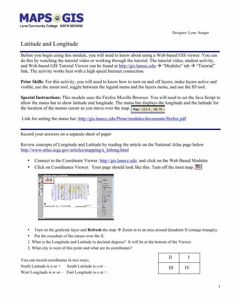
Designer: Lynn Songer
Latitude and Longitude
Before you begin using this module, you will need to know about using a Web-based GIS viewer. You can do this by watching the tutorial video or working through the tutorial. The tutorial video, student activity, and Web-based GIS Tutorial Viewer can be found at http://gis.lanecc.edu “Modules” tab “Tutorial” link. The activity works best with a high speed Internet connection. Prior Skills: For this activity, you will need to know how to turn on and off layers, make layers active and visible, use the zoom tool, toggle between the legend menu and the layers menu, and use the ID tool. Special Instructions: This module uses the Firefox Mozilla Browser. You will need to set the Java Script to allow the status bar to show latitude and longitude. The status bar displays the longitude and the latitude for the location of the mouse curser as you move over the map. Link for setting the status bar: http://gis.lanecc.edu/Plone/modules/documents/firefox.pdf
Record your answers on a separate sheet of paper Review concepts of Longitude and Latitude by reading the article on the National Atlas page below http://www-atlas.usgs.gov/articles/mapping/a_latlong.html
• Connect to the Coordinate Viewer. http://gis.lanecc.edu and click on the Web Based Modules • Click on Coordinates Viewer. Your page should look like this. Turn off the inset map.
• Turn on the graticule layer and Refresh the map Zoom in to an area around Quadrant II (orange triangle). • Put the crosshair of the cursor over the II. 1. What is the Longitude and Latitude in decimal degrees? It will be at the bottom of the Viewer. 2. What city is west of this point and what are its coordinates?
You can record coordinates in two ways, North Latitude is n or + South Latitude is s or – West Longitude is w or – East Longitude is e or +
II I
III IV
2
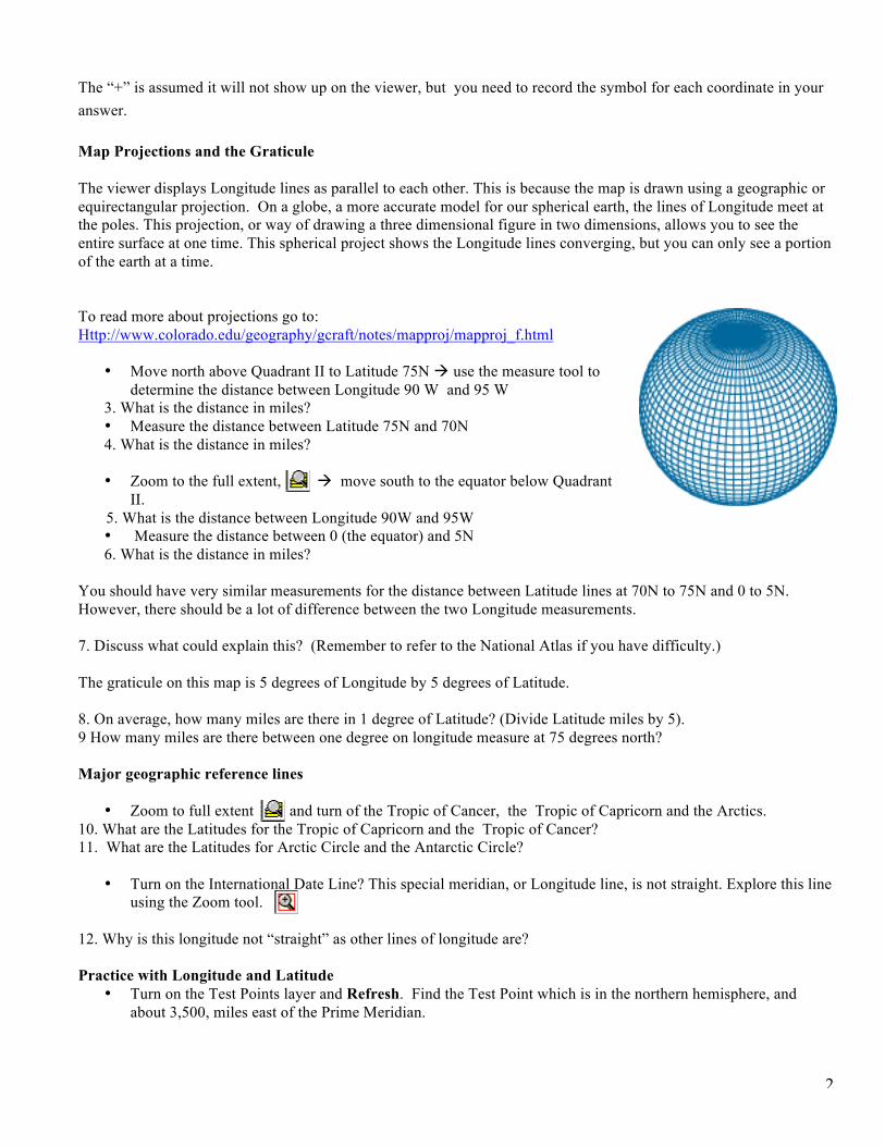
The “+” is assumed it will not show up on the viewer, but you need to record the symbol for each coordinate in your answer. Map Projections and the Graticule The viewer displays Longitude lines as parallel to each other. This is because the map is drawn using a geographic or equirectangular projection. On a globe, a more accurate model for our spherical earth, the lines of Longitude meet at the poles. This projection, or way of drawing a three dimensional figure in two dimensions, allows you to see the entire surface at one time. This spherical project shows the Longitude lines converging, but you can only see a portion of the earth at a time. To read more about projections go to: Http://www.colorado.edu/geography/gcraft/notes/mapproj/mapproj_f.html
• Move north above Quadrant II to Latitude 75N use the measure tool to determine the distance between Longitude 90 W and 95 W
3. What is the distance in miles? • Measure the distance between Latitude 75N and 70N 4. What is the distance in miles?
• Zoom to the full extent, move south to the equator below Quadrant
II. 5. What is the distance between Longitude 90W and 95W
• Measure the distance between 0 (the equator) and 5N 6. What is the distance in miles?
You should have very similar measurements for the distance between Latitude lines at 70N to 75N and 0 to 5N. However, there should be a lot of difference between the two Longitude measurements. 7. Discuss what could explain this? (Remember to refer to the National Atlas if you have difficulty.) The graticule on this map is 5 degrees of Longitude by 5 degrees of Latitude. 8. On average, how many miles are there in 1 degree of Latitude? (Divide Latitude miles by 5). 9 How many miles are there between one degree on longitude measure at 75 degrees north? Major geographic reference lines
• Zoom to full extent and turn of the Tropic of Cancer, the Tropic of Capricorn and the Arctics. 10. What are the Latitudes for the Tropic of Capricorn and the Tropic of Cancer? 11. What are the Latitudes for Arctic Circle and the Antarctic Circle?
• Turn on the International Date Line? This special meridian, or Longitude line, is not straight. Explore this line using the Zoom tool.
12. Why is this longitude not “straight” as other lines of longitude are? Practice with Longitude and Latitude
• Turn on the Test Points layer and Refresh. Find the Test Point which is in the northern hemisphere, and about 3,500, miles east of the Prime Meridian.
3
13. What is the number of the Test Point and its coordinates?
• Find the check point which is in the western hemisphere and approximately 4000 miles southwest of the location were the prime meridian and the equator cross?
14. What is the number of the Test Point and its coordinates? Find and Measure a specific feature
• Make “river” Visible and Active and Refresh
• Use the Find tool. • Type in Murray in the window and Click Find String
• Click on the number 1 in the table
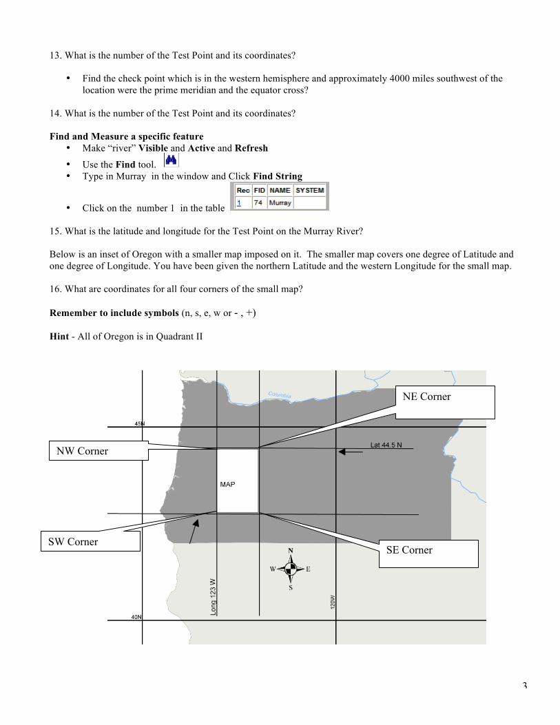
15. What is the latitude and longitude for the Test Point on the Murray River? Below is an inset of Oregon with a smaller map imposed on it. The smaller map covers one degree of Latitude and one degree of Longitude. You have been given the northern Latitude and the western Longitude for the small map. 16. What are coordinates for all four corners of the small map? Remember to include symbols (n, s, e, w or - , +) Hint - All of Oregon is in Quadrant II
NE Corner
SE Corner
NW Corner
SW Corner