Embed Size (px)
Citation preview
2. Sustainability Appraisal
2.5. The Sustainability Appraisal / Strategic Environmental Assessment (SA / SEA)
scoping exercise was undertaken between January – April 2006. The process identified
key strategic problems, objectives and issues for sustainability. The broad issues
identified were as follows:
• Climate change;
• Economic development / housing provision;
• Transport;
• Protection of the landscape and biodiversity;
• Town centre vitality; and
• Cultural change.
2.6. A detailed discussion of each of the broad issues identified is contained in
the Sustainability Appraisal / Strategic Environmental Assessment Scoping Report
(March 2006).
Social, Economic and Environmental Baseline
2.7. In order to ensure that a robust basis was established on which to develop a
spatial strategy for the LDP, a review was undertaken of key social, economic
and environmental data. The review of the available data supports the issues
identified through the pre deposit consultation process and SA / SEA Scoping
exercise. The analysis provides a clear picture of the social, economic and
environmental issues which need to be addressed through the LDP process.
The key trends identified are as follows:
Fig.1 Key Social Trends
NatureConservation
Supplementary Planning Guidance:
Adopted March 2011
LDP nature conservation 2011_Layout 1 12/07/2011 08:15 Page 1

LDP nature conservation 2011_Layout 1 12/07/2011 08:15 Page 2
Nature Conservation
Local Development Plan 2006 - 2021 • 3
Contents
1. Introduction .....................................................................................................4
2. Policy Context ..................................................................................................4
3. Issues ..............................................................................................................5
4. Planning Objectives and Requirements..........................................................7
4.1 General considerations.........................................................................7
4.2 Specific Types of Development Sites .................................................10
5. Appendices.....................................................................................................135.1 Appendix 1: Regionally Important Geological and
Geomorphological Sites (RIGS) ......................................13
5.2 Appendix 2: Sites of Importance for Nature Conservation (SINC) ....14
5.3 Appendix 3: Sources of Guidance and Advice ...................................17
5.4 Appendix 4: Description of Rhondda Cynon Taf...............................19
6. Bibliography...................................................................................................21
LDP nature conservation 2011_Layout 1 12/07/2011 08:15 Page 3
Supplementary Planning Guidance
4 • Local Development Plan 2006 -2021
1. Introduction
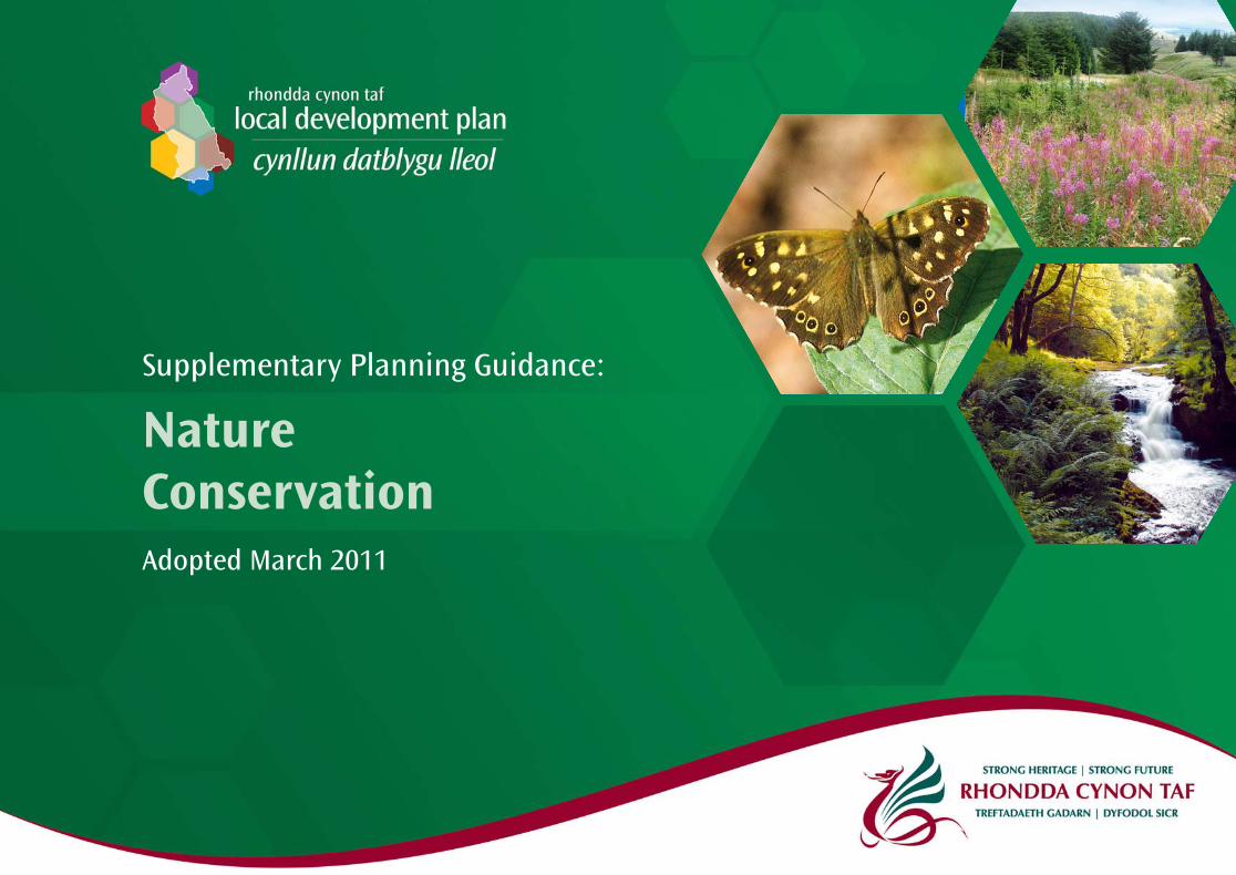
1.1 This Supplementary Planning Guidance (SPG) for Nature Conservation has
been produced in conjunction with the Rhondda Cynon Taf Local
Development Plan and provides additional guidance to support the policies,
allocations and constraints identified in the Plan. For the purposes of this
SPG, nature conservation includes biodiversity, soil and earth science features.
1.2 Rhondda Cynon Taf is situated in the South Wales Coalfield. The earth science
heritage reflects the rocks, geological processes, geomorphology and industrial
history of the County. The geology, climate, soil, landscape, wildlife, land-use,
history and culture of the area are closely interconnected. In common with
other areas of the Valleys, the extent of semi-natural habitat is unusually high,
as is the diversity of habitats. This is one of the key reasons why so much of
the County Borough is of nature conservation value. There is a huge variety
of original habitats in a small area, from upland crags and scree to floodplain
meadows. There are important concentrations of nationally significant
habitats and locally distinctive post-industrial biodiversity features. As a
consequence, the County Borough supports a wide range of species.
2. Policy Context
2.1 The documents listed in the bibliography have informed the Local
Development Plan and this Nature Conservation Supplementary Planning
Guidance. For each reference, a brief description of its relevance to Rhondda
Cynon Taf or the planning process is outlined.
2.2 The Rhondda Cynon Taf Local Development Plan (LDP) sets out the policies
that will be applied in Rhondda Cynon Taf. It also identifies the constraints
on development and allocates sites for specific uses.
2.3 Relevant Policies in the LDP:
Policy AW 8 - The Protection and Enhancement of the NaturalEnvironment
Rhondda Cynon Taf’s distinctive natural heritage will be preserved and enhanced by
protecting it from inappropriate development. Development proposals will only be
permitted where:-
1) They would not cause harm to the features of a Site of Importance for Nature
Conservation (SINC) or Regionally Important Geological Site (RIGS) or other
locally designated sites, unless it can be demonstrated that:-
a) The proposal is directly necessary for the positive management of the
site; or
b) The proposal would not unacceptably impact on the features of the site
for which it has been designated; or
c) The development could not reasonably be located elsewhere and the
benefits of the proposed development clearly outweigh the nature
conservation value of the site.
LDP nature conservation 2011_Layout 1 12/07/2011 08:15 Page 4
Nature Conservation
Local Development Plan 2006 -2021 • 5
2) There would be no unacceptable impact upon features of importance to
landscape or nature conservation, including ecological networks, the quality
of natural resources such as air, water and soil, and the natural drainage of
surface water.
All development proposals, including those in built up areas, that may affect
protected and priority species will be required to demonstrate what measures are
proposed for the protection and management of the species and the mitigation and
compensation of potential impacts. Development proposals must be accompanied
by appropriate ecological surveys and appraisals, as requested by the Council.
Development proposals that contribute to the management or development of
Ecological Networks will be supported.
Policy NSA 26 – Cynon Valley River Park
Development that will contribute to the achievement of the Cynon Valley River Park
Strategy will be supported. This includes:
1. Proposals for the protection, enhancement, enlargement, connectivity and
management of important wildlife sites, species and features of nature
conservation value and water quality.
2. Proposals to promote public access on foot and by cycle, mitigate and adapt to
climate change, encourage health and well-being and support heritage and
tourism.
2.4 The Constraints Map shows the location of the Special Areas of Conservation
and Sites of Special Scientific Interest, with the Proposals Map showing the
locations of the Sites of Importance for Nature Conservation, Regionally
Important Geological Sites and Local Nature Reserves within the County
Borough.
3. Issues
3.1 Biodiversity is defined as ‘the variety of life’ and includes plants and animals
(species), the places where they live (habitats) and the relationships between
them (ecosystems). Planning policy aims to halt biodiversity loss, protect
ecosystem services and where possible contribute to its enhancement.
3.2 Earth Science includes the underlying geology (solid rock and surface deposits)
together with the natural geomorphologic processes at work in the landscape.
Earth science features have developed over very long timescales and cannot
be replaced. Earth science resources may also be of economic value. The
objective of the planning policy is to retain the significant feature(s) of the
identified sites.
3.3 The soil is the interface between earth science and biodiversity. Soils have a
major biodiversity value, with at least half of all species living below ground.
Soils are also significant carbon stores. The main threats to Welsh soils are
from climate change and the decline in organic matter, from soil sealing (for
example by buildings and roads), from contamination (including acidification
and eutrophication), soil erosion, and degradation of soil structure and soil
loss to extraction.
LDP nature conservation 2011_Layout 1 12/07/2011 08:15 Page 5
Supplementary Planning Guidance
6 • Local Development Plan 2006 -2021
3.4 Ecosystem services are those services provided by the natural environment
that benefit people (Defra 2007). Some, such as food, fibre and fuel provision,
recreation and appreciation of nature, are well known. Other services such
as climate regulation, purification of air and water, flood protection, soil
formation and nutrient cycling receive less recognition but directly and
indirectly affect human well-being.
3.5 Section 40(1) of Natural Environment and Rural Communities Act 2006 (NERC)
places a duty on every public authority, in exercising its functions, to “have
regard, so far as is consistent with the proper exercise of those functions, to
the purpose of conserving biodiversity.” This guidance sets out the manner
in which the Local Planning Authority will comply with this duty.
3.6 Protected Sites
Protected sites include Special Areas of Conservation, designated by the Welsh
Government, Sites of Special Scientific Interest, designated by the Countryside
Council for Wales, and Sites of Importance for Nature Conservation (SINC) and
Regionally Important Geological Sites (RIGS) designated as part of the LDP.
3.6.1 RIGS have been designated on the basis of an Earth Science Audit. For each
site the primary and secondary features of importance have been identified.
The Earth Science Audit and the RIGS descriptions are published separately.
Further information is provided in Appendix 1.
3.6.2 SINC have been designated on the basis of specific criteria for the Mid Valleys
area of South Wales. For each site the primary and secondary features of
importance are identified. The Mid Valleys Criteria and the SINC descriptions
are published separately. Further information is provided in Appendix 2.
3.6.3 The Local Nature Reserves (LNR) are owned or managed for nature
conservation by Rhondda Cynon Taf County Borough Council. Wildlife Trust
Reserves (WTR) in Rhondda Cynon Taf are owned or leased by the Trust. All
the LNR and WTR fall within Sites of Importance for Nature Conservation.
3.7 Ecological Connectivity and habitat fragmentation are important wildlife
conservation issues. Small, isolated populations of species are far more
vulnerable to extinction than populations that can disperse and interbreed
with other populations. The effects of climate change are likely to increase
local extinctions among small isolated populations. It is therefore important
to maintain and enhance ecological networks of semi-natural habitats that
have a high degree of connectivity. The Habitat Regulations (37) require
planning policies which conserve features of the landscape that are of major
importance for wild flora and fauna, including those linear features that are
essential for the migration, dispersal and genetic exchange of wild species.
3.8 The management of land has important nature conservation implications,
and in a planning context, this is also recognised by the Habitats Regulations.
3.9 Protected Species
The presence (or likely presence) of a protected species is a material planning
consideration and developers must consider this prior to submitting a planning
application.
3.9.1 European protected species are protected under the Conservation (Natural
Habitats, etc.) Regulations 1994 (Referred to in the UK as the Habitat
Regulations) Schedules 2 and 4 list the protected species.
3.9.2 Bats are unusual compared to other protected species as it is extremely
difficult to predict where they may be roosting and foraging. Guidance on
bats and the planning process is currently being produced for use by Local
Planning Authorities in Wales.
LDP nature conservation 2011_Layout 1 12/07/2011 08:15 Page 6
Nature Conservation
Local Development Plan 2006 -2021 • 7
3.9.3 UK protected species are protected under the Wildlife and Countryside Act 1981 as
amended by the Countryside and Rights of Way Act 2000 (CROW). Protected species
are listed under Schedules 1 (Birds), 5 (Animals) and 8 (Plants).
3.9.4 Badgers and their setts are protected under the 1992 Protection of Badgers Act.
3.9.5 All wild birds (with certain exceptions) are given basic protection from intentional
killing or injuring, and damage or destruction of a nest whilst it is in use or being
built. Certain birds are given additional protection.
3.10 Habitats and Species
The Welsh Assembly Government has published a list of habitats and species
of principal importance in Wales, as required under Section 42 of the
Countryside and Rights of Way Act 2000. The presence of these habitats and
species is a material consideration and has informed the SINC criteria.
3.10.1 Action for Nature: the Local Biodiversity Action Plan (LBAP) for Rhondda Cynon
Taf sets out a programme of action for a range of partners to conserve and
enhance the biodiversity of Rhondda Cynon Taf. The LBAP lists the habitats
and species of particular importance in Rhondda Cynon Taf and these have
informed the SINC criteria.
3.10.2 Trees, woodlands and hedges are among the habitats of importance for
wildlife but, additionally, may be protected by Tree Preservation Orders (TPOs),
the Hedgerow Regulations and felling license requirements. TPOs and the
Hedgerow Regulations provide protection for specific trees, woodlands and
specific types of hedgerow and are a material consideration in planning
decisions. Felling licences are required (from the Forestry Commission Wales)
for the removal of trees totalling above 2m3 in volume (for sale) or 5m3 in
other circumstances (per calendar quarter).
3.11 River corridors are an important component of the natural environment in
the County Borough. All major rivers qualify as SINC habitat and many support
protected species. River corridors provide connectivity through urban and
rural areas. The Water Framework Directive requires that all rivers achieve
and maintain good ecological status. Development proposals likely to affect
river corridor habitat, protected species or water quality should have regard
for these issues.
4. Planning Objectives and Requirements
4.1 General Considerations
4.1.1 As a general principle, the Council will expect the developer to provide
sufficient information to inform a decision about the nature conservation
value of the site. Because of the extent of semi-natural habitat in the County
Borough, there are few development sites where nature conservation is not a
relevant issue. Even within the built up area, bats and nesting birds will need
to be considered.
4.1.2 It is therefore recommended that nature conservation issues are considered
as early as possible within the scoping and design of development proposals
and that early consultation is undertaken with the Council to ensure that
relevant information is supplied at the outset and delays avoided.
4.1.3 Information supplied to the Local Planning Authority, as part of a planning
application, will normally be available for the public to view on the application
file. Developers will be expected to provide the ecological information,
submitted in support of their application, to the South East Wales Biodiversity
Record Centre.
LDP nature conservation 2011_Layout 1 12/07/2011 08:15 Page 7
Supplementary Planning Guidance
8 • Local Development Plan 2006 -2021
4.1.4 The following are material considerations to be addressed as part of a
planning application;
4.1.5 Development should not lead to the net loss of biodiversity, should protect
ecosystem services and, where possible, contribute to biodiversity
enhancement, in accordance with the policy principles in LDP policy AW 8.
4.1.6 The significant features of European and nationally designated sites, SINCS
and RIGS should be protected. Applicants will be expected to show how the
features for which the site is designated are to be protected, and where
possible, enhanced.
4.1.7 Where European sites may be affected by development, assessments of likely
significant effects and, where necessary, appropriate assessment should be made.
4.1.8 Development should be carried out in a way that conserves features of the
landscape that are of major importance for wild flora and fauna, including
those linear features that are essential for the migration, dispersal and
genetic exchange of wild species.
4.1.9 Ecological connectivity between habitat patches is generally good in
Rhondda Cynon Taf and the impact of development on this connectivity
will be a material consideration. Development that reduces connectivity
between habitats will not normally be favoured, however there may be
opportunities for development to contribute to ecological connectivity.
Planning decisions will be informed by research work being undertaken at
the local, regional and Wales level with regard to ecological connectivity.
4.1.10 The presence of a protected or priority habitat or species is a material
consideration and must be addressed by the application.
4.1.11 The following paragraphs are relevant to the consideration of applications
with nature conservation implications.
4.1.12 Pre-application enquiries are welcomed, to identify whether the application
is likely to affect a designated site or important species and to identify any
opportunities for enhancement. This initial scoping will identify that either:
i) there is no requirement for detailed ecological assessment or mitigation,
or
ii) a SEWBREC search for statutory protected species is required and/ or
iii) a detailed ecological survey and assessment will be required or
iv) there is sufficient ecological information to recommend refusal on nature
conservation grounds.
4.1.13 The level and detail of the necessary ecological survey and assessment must
be specific to each planning application and should be undertaken by a
suitably qualified ecological consultant at the appropriate time of year. To
determine the requirements, the Local Planning Authority may consult with
statutory consultees. An iterative approach to survey assessment is generally
advocated, with baseline assessments advising the requirement for, and
extent of, more detailed follow-up survey work where necessary.
LDP nature conservation 2011_Layout 1 12/07/2011 08:15 Page 8
Nature Conservation
Local Development Plan 2006 -2021 • 9
4.1.14 In many cases ecological concerns will be restricted to one species or feature. For
example building demolitions may often only require bat and bird surveys. In
other cases a baseline ecological assessment (using standard Phase I Habitat
Survey methodology) may be sufficient in order to assess habitat features and to
identify the potential for statutory protected species. In other cases a detailed
suite of surveys may be required, which could include habitat assessment to
Phase II standards, and/or detailed audits of lower and higher plants,
invertebrates, amphibians, reptiles, fish, birds and mammals.
4.1.15 Ecological survey reports must also include an appraisal of the significance of
features and species within the application site, the impacts and implications of
the proposed development on those features and the extent of mitigation, and
enhancement measures, which the application will provide.
4.1.16 Where a planning application affects trees, woodlands or hedges on or adjacent to
the development site, applicants will be expected to provide information about
these and the impact of their proposals on them, both in respect of their nature
conservation and amenity value. Where important features are affected, the
Council will require a tree report as specified in the British Standards Institutes, BS
5837: Trees in relation to construction.
4.1.17 This report should be based on a survey by an appropriately qualified
aboriculturalist, categorise the trees and set out the arboricultural
implications of the proposed development. For trees etc. that are to be
retained, or areas to be planted, an Arboricultural Method Statement and a
Tree Protection Plan should be provided and Construction Exclusion Zones
identified on the site layout plan. Any specified works to trees etc. should
conform to BS 3998: Recommendations for Tree work.
4.1.18 Where a European Protected Species is likely to be affected by a planning
application, the following three tests will be applied:
i) there is ‘no satisfactory alternative’,
ii) it is ‘not detrimental to the maintenance of the populations of the species
concerned at favourable conservation status in their natural range’ and
iii) it is ‘in the interests of public health and public safety, or for other
imperative reasons of overriding public interest, including those of a social
or economic nature and beneficial consequences of primary importance
for the environment’.
4.1.19 To apply these tests, suitable survey and assessment information is required
before the application is determined, where an application site is considered
to have potential to support a European Protected Species.
4.1.20 Where a European Protected Species is likely to be affected, a licence is
normally required from the Welsh Government under the Habitats
Regulations, and a condition will be added to any grant of planning
permission to produce details of this licence prior to starting works.
4.1.21 Following receipt of the survey and assessment this will be subject to internal
and statutory consultation to assess whether:
i) sufficient nature conservation assessment has been undertaken and
whether a sufficient resolution of issues has been made. If this is the case,
the consultation will identify whether the planning application is either:
a. acceptable under adopted planning policy, and can proceed or;
b. unacceptable, leading to a policy objection.
ii) insufficient nature conservation assessment has been undertaken and
further survey and clarification is required. The planning application may
be recommended for refusal due to a lack of information.
LDP nature conservation 2011_Layout 1 12/07/2011 08:15 Page 9
Supplementary Planning Guidance
10 • Local Development Plan 2006 -2021
4.1.22 Mitigation measures are those measures required to reduce to an acceptable level
the impacts and implications of development on features, habitats or species of
importance. Compensation measures are designed to offset any impacts that
cannot be avoided or mitigated. In certain circumstances, proposed mitigation
and / or compensation may result in the development being considered
acceptable. The extent of mitigation and compensation required will be specific
to the proposal, but could include the retention and long-term management of
habitats and the provision of species-specific measures. The planning proposal
may also be able to provide enhancement measures to actively benefit nature
conservation. This could include positive management of, or providing
connections to, adjacent habitats.
4.1.23 Planning conditions and / or planning obligations will be used to ensure that the
proposed measures are undertaken. Planning obligations will be used where
measures require long-term application (over five years), where monitoring will
extend over a prolonged period, or the Council or a third party, takes on the
management of an area with commuted management sums.
4.1.24 Similarly, where development proposals include areas of informal open space,
water and landscape features, retained or planted trees, nature conservation areas
or features, planning conditions and or planning obligations will be sought where
appropriate to ensure that the land or feature is appropriately managed.
4.2 Specific Types of Developments / Sites
4.2.1 In addition to the general considerations outlined above, the following
paragraphs provide guidance on specific types of developments/ sites. These
are not exhaustive.
4.2.2 The design of household extensions can have implications for nature
conservation, typically in relation to bats or nesting birds. Where an extension
will affect a large tree, an existing roof, or involves demolition of a building
or structure, the applicant should seek advice from the Council prior to
submitting an application. Opportunities to achieve a net benefit for
biodiversity, for example through the provision of nesting or roosting boxes,
will be encouraged.
4.2.3 Buildings can be of particular importance as nesting or roosting places for
birds or bats. This is true of rural buildings such as barns and urban buildings
such as schools, chapels and housing. The conversion of older buildings
should provide opportunities to build replacement or new features into
developments.
4.2.4 In respect of larger development sites, the SPG on Design and Placemaking
identifies the need to integrate nature conservation concerns into the design
of new developments from the outset. This will enable areas of high nature
conservation value to be avoided and positive contributions to nature
conservation to be identified.
4.2.5 The holistic consideration of landscaping, sustainable urban drainage, active
travel, informal and formal open space and nature conservation should be a
key element of place making.
4.2.6 All larger developments should consider opportunities to achieve net benefit
for biodiversity within their design. These should include, where appropriate,
the use of up to date best practice, such as:
• The use of technologies, such as green / brown roofs;
• The inclusion of planting and landscaping schemes that benefit wildlife;
• Siting of development to exclude areas of biodiversity interest;
LDP nature conservation 2011_Layout 1 12/07/2011 08:15 Page 10
Nature Conservation
Local Development Plan 2006 -2021 • 11
• Enhancement, creation or restoration of locally distinctive natural habitats;
• Enhancement measures for species including the provision of artificialnesting sites / roosting sites / hibernacula;
• Sustainable management;
• Sustainable urban drainage systems; and
• Ecological connectivity.
4.2.7 The development of each strategic site should aim to achieve no net loss of
biodiversity. However, it is recognised that because of the strategic importance of
these sites this objective cannot always be achieved. Where a loss of biodiversity
cannot be avoided, the Council require a comprehensive management, mitigation
and compensation package. This will require the integration of nature conservation
considerations from the outset. Sufficient survey and assessment work will need
to be undertaken at each stage to establish the extent of the existing nature
conservation interest, the areas that should be protected and areas where
enhancement can be achieved.
4.2.8 Where schemes are required to reach a minimum of Level 3 of the Code for
Sustainable Homes/ or BREEAM “Very Good” standard for commercial development,
schools, etc, the ecology requirements of these standards should be considered in
light of this SPG. Developers should discuss this element of the proposals with the
Council’s Ecologist at an early stage.
4.2.9 Roads should be designed to minimise negative impact on the natural
environment and opportunities for biodiversity enhancement should be
pursued where possible. Again, the holistic consideration of landscaping,
active travel, informal and formal open space and nature conservation is
encouraged. The route and design should seek to minimise habitat
damage (including the effects of lighting, noise, pollution, drainage and
habitat fragmentation) and mitigate impacts and compensate for residual
habitat loss. Where protected species are likely to be present, special
measures will be required (for example newt gully pots, dormouse
crossings, dark corridors).
4.2.10 Where geological exposures are created by highway works, consideration
should be given to protecting these exposures for geological study and
conservation. Geo-netting should not be undertaken without prior
consultation with the Countryside Council for Wales.
4.2.11 The landscaping of highways provides opportunities for mitigation and
enhancement measures. Linear corridors can contribute to ecological
connectivity between habitat patches in both urban and rural areas. In general,
native grassland should be encouraged and tree or hedge planting with
indigenous species of local provenance will be expected. Exotic planting, soil
enrichment, imported seed mixes and high maintenance specifications should
be restricted to high profile urban locations.
4.2.12 Where any development requires the creation or upgrading of a highway
or access, the nature conservation implications of this should be addressed.
LDP nature conservation 2011_Layout 1 12/07/2011 08:15 Page 11
Supplementary Planning Guidance
12 • Local Development Plan 2006 -2021
4.2.13 Renewable energy proposals that will cause significant damage to existing
carbon/methane stores, such as ancient woodland or deep peat deposits,
should be assessed for their net greenhouse gas emissions. This should be
undertaken using national and international guidance and best practice
relating to carbon budgets.
4.2.14 The design of wind farms on the upland afforested plateau must address
the impact on the deep peat soils and hydrology, of the individual
turbines, the access and the power line infrastructure. Developers will be
expected to survey, to map the extent of the habitat and features present
on the site and in the surrounding area. The assessment should include
the alternative designs or locations considered; how adverse effects will
be avoided wherever possible; how unavoidable impacts will be reduced
and mitigated; and how impacts, that cannot be avoided or mitigated, will
be compensated. Proposals for the long-term management of habitat and
monitoring of impacts will be required. Major wind farms may also have
significant impacts on bird and bat populations and the developer should
indicate how these impacts have been avoided, minimised or
compensated for. However, it should be considered that large windfarm
projects will be subject to the requirements of the Environmental Impact
Assessment Regulations. The issues set out in this SPG should therefore not
result in a duplication of the scoping requirements for the environmental
statement of the Environmental Impact Assessment process.
4.2.15 Small scale and domestic wind turbines may also have impacts on birds and
bats, which should be considered in the design and location of the turbine.
4.2.16 Biomass energy proposals should also be assessed for their net carbon savings
contribution. Energy crops that are dependent on high levels of manufactured
fertiliser input or high transport energy demands are unlikely to lead to reduced
carbon emissions. Displacement of local food production on better quality
agricultural land will not be encouraged, although agricultural waste (e.g. straw)
may provide feedstock for small scale biomass developments.
4.2.17 The Environmental Impact Assessment Regulations (semi-natural areas and
uncultivated land) will apply if semi-natural or uncultivated land is brought
into production. Biomass proposals should avoid areas of high nature
conservation value.
4.2.18 Hydroelectric power schemes should be designed to minimise their impact
on the river environment and in particular on otters and migratory fish.
The Environmental Agency Wales may be consulted by the Council with
regard to nature conservation impacts.
4.2.19 Small scale solar, photovoltaic and geothermal energy proposals are
unlikely to have major nature conservation implications. However, where
bats are likely to be present, further advice should be sought.
LDP nature conservation 2011_Layout 1 12/07/2011 08:15 Page 12
Nature Conservation
Local Development Plan 2006 -2021 • 13
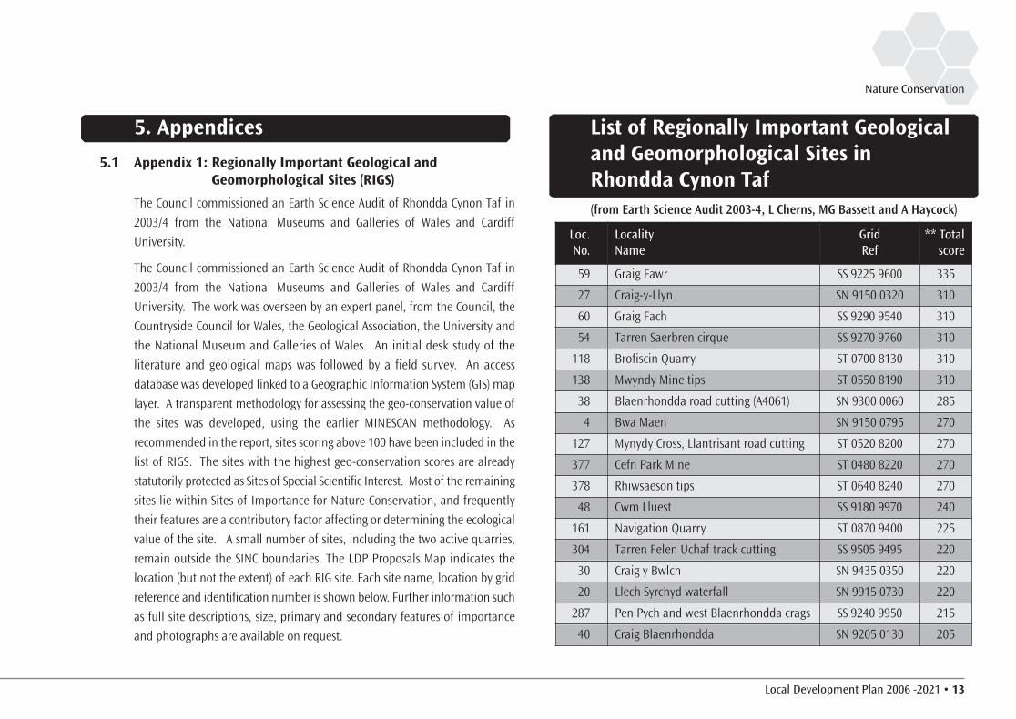
List of Regionally Important Geologicaland Geomorphological Sites in Rhondda Cynon Taf(from Earth Science Audit 2003-4, L Cherns, MG Bassett and A Haycock)
Loc.No.
Locality Name
Grid Ref
** Totalscore
59 Graig Fawr SS 9225 9600 335
27 Craig-y-Llyn SN 9150 0320 310
60 Graig Fach SS 9290 9540 310
54 Tarren Saerbren cirque SS 9270 9760 310
118 Brofiscin Quarry ST 0700 8130 310
138 Mwyndy Mine tips ST 0550 8190 310
38 Blaenrhondda road cutting (A4061) SN 9300 0060 285
4 Bwa Maen SN 9150 0795 270
127 Mynydy Cross, Llantrisant road cutting ST 0520 8200 270
377 Cefn Park Mine ST 0480 8220 270
378 Rhiwsaeson tips ST 0640 8240 270
48 Cwm Lluest SS 9180 9970 240
161 Navigation Quarry ST 0870 9400 225
304 Tarren Felen Uchaf track cutting SS 9505 9495 220
30 Craig y Bwlch SN 9435 0350 220
20 Llech Syrchyd waterfall SN 9915 0730 220
287 Pen Pych and west Blaenrhondda crags SS 9240 9950 215
40 Craig Blaenrhondda SN 9205 0130 205
5. Appendices
5.1 Appendix 1: Regionally Important Geological andGeomorphological Sites (RIGS)
The Council commissioned an Earth Science Audit of Rhondda Cynon Taf in
2003/4 from the National Museums and Galleries of Wales and Cardiff
University.
The Council commissioned an Earth Science Audit of Rhondda Cynon Taf in
2003/4 from the National Museums and Galleries of Wales and Cardiff
University. The work was overseen by an expert panel, from the Council, the
Countryside Council for Wales, the Geological Association, the University and
the National Museum and Galleries of Wales. An initial desk study of the
literature and geological maps was followed by a field survey. An access
database was developed linked to a Geographic Information System (GIS) map
layer. A transparent methodology for assessing the geo-conservation value of
the sites was developed, using the earlier MINESCAN methodology. As
recommended in the report, sites scoring above 100 have been included in the
list of RIGS. The sites with the highest geo-conservation scores are already
statutorily protected as Sites of Special Scientific Interest. Most of the remaining
sites lie within Sites of Importance for Nature Conservation, and frequently
their features are a contributory factor affecting or determining the ecological
value of the site. A small number of sites, including the two active quarries,
remain outside the SINC boundaries. The LDP Proposals Map indicates the
location (but not the extent) of each RIG site. Each site name, location by grid
reference and identification number is shown below. Further information such
as full site descriptions, size, primary and secondary features of importance
and photographs are available on request.
LDP nature conservation 2011_Layout 1 12/07/2011 08:16 Page 13
Supplementary Planning Guidance
14 • Local Development Plan 2006 -2021
5.2 Appendix 2: Sites of Importance for Nature Conservation (SINC)
SINC are an important resource in Rhondda Cynon Taf, protecting locally and
nationally important habitats and species.
The Mid Valleys Criteria used for the Rhondda Cynon Taf Local Development
Plan provide objective, scientific, sub-regional criteria for the Mid-Valleys area
(Rhondda Cynon Taf, Merthyr, Caerphilly and Blaenau Gwent).
Loc.No.
Locality Name
Grid Ref
** Totalscore
3 Lower section of River Sychryd SN 9108 0789 100
430 Tarren Maen-du quarry and landslide SS 9375 9760 100
158 River Taff terrace deposits ST 0825 9350 100
348 Gelynog colliery spoil tips, Beddau ST 0568 8534 120
92 Craig-yr-ysgol SN 9590 0265 115
383 Taffs Well hematite workings ST 1360 8370 110
1 Old Dinas quarry, Pen-cae drain SN 9170 0795 105
120 Small crags west of Gadir Wen House ST 0660 8062 105
3 Lower section of River Sychryd SN 9108 0789 100
430 Tarren Maen-du quarry and landslide SS 9375 9760 100
158 River Taff terrace deposits ST 0825 9350 100
** Total score refer to the geo-conservation assessment
Loc.No.
Locality Name
Grid Ref
** Totalscore
52 Craig Selsig and Craig y Ddelw SS 9170 9775 205
51 Blaencwm landslide SS 9180 9840 205
133 Forest Wood Quarry ST 0150 7970 205
159 The Gap quarry ST 0785 9643 200
32 Lower Craig Blaenrhondda crags and tip SN 9231 0135 200
50 Nant y Gwair stream gulley and Cwar y Offeiriad SS 9115 9872 200
93 Tarren y Bwllfa SN 9650 0175 180
34 River Rhondda Waterfall SN 9228 0150 170
546 Coed-y-wiw tips ST 0005 8065 170
49 Nant yr Ychen stream gulley and crags SS 9160 9925 160
536 South Ty Rhos crags SN 9740 0395 160
174 Glyncoch Quarry ST 0790 9190 155
124 Hendy/Miskin Quarry ST 0555 8120 155
210 Craig yr Eos South Dinas Quarry ST 0028 9136 150
163 West Navigation quarry ST 0857 9410 150
375 Daren y Celyn Quarry ST 0785 9635 140
531 Bwllfa Road tips SN 9700 0300 140
407 Mynydd yr Eglwys landslide SS 9760 9550 140
348 Gelynog colliery spoil tips, Beddau ST 0568 8534 120
92 Craig-yr-ysgol SN 9590 0265 115
383 Taffs Well hematite workings ST 1360 8370 110
1 Old Dinas quarry, Pen-cae drain SN 9170 0795 105
120 Small crags west of Gadir Wen House ST 0660 8062 105
LDP nature conservation 2011_Layout 1 12/07/2011 08:16 Page 14
Nature Conservation
Local Development Plan 2006 -2021 • 15
List of Sites of Importance for Nature Conservation
No. Name No. Name
1 Coed Wernhir 21 Mynydd Bwllffa /Mynydd-y-gyngon
2 Werfa Farm 22 Cwm Dare North
3 Nant Fforch 23 Cwm Dare South
4 Brickyard Mire 24 Dare Valley
5 Rhigos Tramway 25 Aberdare South
6 Cwm Gwrelych 26 Mynydd Ystradffernol
7 Hirwaun Industrial Estate 27 Garn Wen and Panwen Garreg-wen
8 Clydach Vale 28 Rhos Gwawr
9 Hirwaun Ponds 29 Aberdare Mountain
10 Hirwaun Common 30 Nant y Wenallt
11 Gelli-ben-uchel 31 Cwm y Felin Newydd
12 Hirwaun Ponds (North) 32 Aberdare Canal
13 Hirwaun Iron Works 33 Mid Cynon Floodplain
14 Glyncornel 34 Cwmbach Slopes
15 Upper Cynon Floodplain 35 Gelli Slopes
16 Nant Hir Valley and Reservoir 36 Coed Tir Estyll
17 Nant Hir Gwyddel 37 Cefnpennar
18 Llwydcoed Slopes 38 St Gwynno Forestry
19 Bryn-defaid Heath 39 Mynydd Merthyr
20 East Llwydcoed 40 Mynydd Brith-weunydd / Llwynypia hillside
The geography of the County Borough is reflected in the nature of the SINC.
In the uplands, where there is less built development and extensive areas of
semi natural habitat, SINC tend to be larger than in the lowlands.
The locations of the SINC are shown on the Proposals Map. Individual SINC
plans and the site descriptions are available on request. The site description
includes the primary and secondary features of importance together with
information about survey and other evidence relating to the site.
The sites, shown on the Local Development Plan Proposals Map, are based on
criteria applied within the context of the evidence considered at the time when
the LDP was prepared.
If an unconstrained development site meets the criteria for designation as a
protected site, it will be treated as if the site was so designated.
If the development proposed does not adversely affect the special features of
the protected site then the designation would not prevent the development.
If the developer claims that the site does not meet the criteria for protection,
it will be necessary to show that the site did not meet the criteria at the time
of designation.
LDP nature conservation 2011_Layout 1 12/07/2011 08:16 Page 15
Supplementary Planning Guidance
16 • Local Development Plan 2006 -2021
No. Name No. Name
81 Pontypridd Golf Course 101 Cefn Hendy Community Woodlands
82 Coed-Pen-Maen Common 102 Coed-yr-Hendy
83Mynydd Meiros / Upper Ewenny Fach
103 Pant Marsh
84 Meiros 104 Y Graig
85Llantrisant Forestry and Craig Melyn
105 Llantrisant Common
86 Cynllan Wood 106 Cefn Craig Amos
87 Hendre Owen / Trecastell Tip 107 Tonyrefail Mountains
88 Coed Trecastell 108 Llanilid Valley
89 Gwaun Llanhari Wood 109 Garth-Grabban Slopes
90 Ty’n Y Waun 110 Rhiwfelin Fawr
91 Coedcae Marsh 111 Nant Muchudd
92 River Ely 112 Coedcae-mawr
93 Ty-Du 113 Pant-y-ddraenen
94Ty-Draw (Pontyclunfloodmeadows)
114 Crofft -yr-haidd Marshy Grassland
95 Llanharry Quarry 115 Nant Gelliwion / Waun Castellau
96 Cowbridge Road Playing Field 116 Darran Park
97 Ceulan Farm 117 Tonyrefail East
98 Heol Miskin Woodland 118 Cae’r-ysgol Woodland
99 Talygarn Woodland and Lake 119 The Glyn
100 East Miskin 120 Mynydd y Glyn
No. Name No. Name
41 Twyn Tyllaudefaid Valley Mire 61 Blaenllechau Woodland
42 Pont-y-gwaith Hillside 62 Penrhiw Cradoc Fields
43 Mynydd Troed-y-rhiw Slopes 63 Cwm Clydach
44 Penrhiw Flushes 64 Mynydd Ty’n-tyle Slopes
45 Birch Grove Slopes 65 Old Smokey Slopes
46 Y Ffrwd 66 Coed Fforest Isaf-Uchaf
47Mynydd Dinas / Mynydd y Cymmer
67 Perthcelyn Slopes
48 Bronwydd Park 68 Pen-twyn-isaf
49 Trebanog Slopes 69 Tyntetown Slopes
50 Cilely Farm Rhos Pasture 70 Darren y Celyn
51 Cwm Hafod Woodland 71 Coed Pen-y-parc
52Coed-yr-Hafod WoodlandComplex
72 Heol-y-Mynach Pastures
53Llys Nant and Graig Twyn-y-glog Woodlands
73 Buarth-y-Capel wetland
54Mynydd Blaenrhondda andMynydd Ty-Isaf
74 Dan y Cribyn
55 Craig Pwllfa 75 Lower Clydach Woodlands
56 Abercwmboi Lake 76 Maerdy Colliery
57 Lower Cynon 77 Craig-yr-Hesg / Lan Wood
58 Treherbert Slopes 78 Craig-Evan Leyshon Common
59 Mynydd y Ffaldau 79 Mynydd Eglwysilian
60 Mountain Ash Slopes 80 Pont Sion Norton Woodland and Ffridd
LDP nature conservation 2011_Layout 1 12/07/2011 08:16 Page 16

Nature Conservation
Local Development Plan 2006 -2021 • 17
No. Name No. Name
121 Penrhiw-fer Road Woodland 141 Coed y Fardre
122 Penrhiw-fer Road West 142 Taff and Rhondda Rivers
123 Ystrad Slopes 143 Llantwit Fardre West
124Mynydd Gelli-wion andGellwion Slopes
144 Caeau’r-llan Slopes
125 Coed Craig-Fach 145 Diswylfa Woodland
126 Treforest Slopes 146 Efail Isaf South
127 Coed Castellau 147 Afon Clun Valley and Rhiwsaeson Hill
128 Pen-y-coedcae Grassland 148Nant Myddlyn / Afon Clun / Tor-y-Coed Woodland
129 Coedcae-du 149 Ty Newydd Woods and Grassland
130 Rhyd-y-llech 150 Mwyndy Lake
131 Cwm Colliery Grasslands 151 Cefn Parc Cemetery
132 Cwm Colliery Spoil and Lake 152 A4119 Road Verge
133 Maendy Quarry 153Hendy Quarry and Miskin ManorSlopes
134 Croesged Grassland 154 Fforest Wood Quarry
135 Beddau East 155 Rhydhalog
136 Duffryn Dowlais 156 Coed y Gedrys and Garth-fawr
137 Llantwit Fardre Marsh 157 Fforest Fawr
138 Tonteg Marsh 158Ty-Rhiw Woodlands and PenrhosCutting
139 Heol-y-Cawl 159 Craig Yr Allt Slopes
140 Brynhill Chapel Grassland 160 Coed Caedyrys / Tir Thomas Jones Tip
No. Name No. Name
161 The Willowford 173 Fernbank East
162 Taff Trail Cycletrack 174Llanharan Marsh / Brynna Woods /Jubilee Marsh
163 Fforestnewydd 175Ewenny Fach and associatedwoodlands
164 Graig Cottages 176 Llanilid
165 Mynydd yr Eglwys 177 Dolau Slopes
166 Parc Eirin 178 Cwmparc
167 Gilfach Road Wetlands 179 Mynydd Tyle-coch
168 Mynydd y Gilfach 180 Nant Pentre Forestry
169 Gilfach Goch Slopes 181 Treorchy Slopes
170 Nant Ciwc 182 Treorchy Cemetery
171 Llanbad-fawr Marsh 183 Ton Pentre Slopes
172 Cwm Llanbad
5.3 Appendix 3 - Sources of Guidance and Advice
Countryside Council for Wales
The Countryside Council for Wales is the Government's statutory advisor onsustaining natural beauty, wildlife and the opportunity for outdoor enjoymentin Wales and its inshore waters.
Headquarters, Maes y Ffynnon, Penrhosgarnedd, Bangor, Gwynedd LL57 2DWTelephone: 0845 1306229, Fax: 01248 355782, Email: [email protected]
South and East Wales Office, Unit 7, Castelton Court,Fortran Road, St Mellon's, Cardiff CF3 0LTTelephone: 0845 1306229, Fax: 01248 355782, Email: [email protected]
LDP nature conservation 2011_Layout 1 12/07/2011 08:16 Page 17
Supplementary Planning Guidance
18 • Local Development Plan 2006 -2021
Environment Agency Wales
Environment Agency Wales reports to the Welsh Government and is the environmental
regulator with wide responsibilities for managing the environment, acting as a
champion for the environment, reducing pollution and enforcing pollution legislation,
overseeing the management of waste, water resources and freshwater fisheries,
reducing the harm caused by flooding and influencing others to achieve positive
environmental outcomes by changing attitudes and behaviour.
Head Office, Cambria House, 29 Newport Road, Cardiff CF24 0TP
South East Area Office, Rivers House, St Mellons Business Park
St Mellons, Cardiff CF3 0EY
Telephone: 08708 506506
Email: [email protected]
www.environment-agency.wales.gov.uk
Forestry Commission Wales
Forestry Commission Wales are responsible for managing the 38% of Welsh woodlands
owned by the Welsh Government. They advise on the development of forestry policy
and its implementation. They also encourage sustainable woodland management
within the private sector and are responsible for administering grants and regulatory
work, including licensing for felling and replanting.
Victoria House, Victoria Terrace, Aberystwyth, Ceredigion SY23 2DQ
Telephone: 0845 604 0845, www.forestry.gov.uk/wales
Welsh Government Department of Rural Affairs
Welsh Government Department of Rural Affairs is responsible for the
implementation of The Environmental Impact Assessment (Agriculture) (Wales)
Regulations 2007.
www.wales.gov.uk/about/departments/depc
Wildlife Trust for South and West Wales
The Wildlife Trust of South and West Wales is a charitable organisation working
exclusively on all aspects of wildlife conservation in South and West Wales. They
provide habitat and species management advice directly to those managing land
and work with key partners and local people to promote habitat enhancement
and restoration.
The Nature Centre, Bridgend
Telephone: 01656 724100
The Welsh Wildlife Centre, Cilgerran
Telephone: 01239 621212, E-mail: [email protected], www.welshwildlife.org
South East Wales Biodiversity Records Centre
South East Wales Biodiversity Records Centre (SEWBREC) is the centre for the collation,
management and dissemination of biodiversity data for South East Wales.
13 St Andrews Crescent, Cardiff CF10 3DB
Telephone: 029 2064 1110, Fax: 029 2038 7354Email: [email protected],
www.sewbrec.org.uk
LDP nature conservation 2011_Layout 1 12/07/2011 08:16 Page 18
Nature Conservation
Local Development Plan 2006 -2021 • 19
Planning for Biodiversity by David Tyldesley and RTPI (1999)
This is a good practice guide that aims to help raise awareness of biodiversity
conservation in the planning system and to improve understanding, help resolve
conflict and create opportunities and provide practical guidance on planning
instruments that may contribute to biodiversity conservation.
www.rtpi.org.uk
British Standard Institute
The British Standard Institute has published PAS 2010:2006 Planning to halt the
loss of biodiversity. This has been developed to help the planning system play its
part in halting the decline of biodiversity.
www.bsigroup.com/Shop
Institute of Ecology and Environmental Management (IEEM)
THE IEEM is a non-profit professional body that represents and supports ecologists
and environmental managers in the UK and abroad. It provides a variety of
services to develop competency and standards in ecology and environmental
management.
IEEM, 43 Southgate Street, Winchester, Hampshire SO23 9EH
Telephone: 01962 868626, Fax: 01962 868625
Email: [email protected], www.ieem.net
Think Wildlife Think Protected Species
Provides guidance on the protected species likely to be associated with particular
development types or sites in the Glamorgan or Gwent areas.
Developing Naturally by Mike Oxford et al (2000)
This is a good practice guide developed for the Association of Local Government
Ecologists relating to development and the planning system in the UK.
5.4 Appendix 4 - Description of Rhondda Cynon Taf
Rhondda Cynon Taf is situated in the South Wales Coalfield. The geology, landscape,
wildlife, land-use, history and culture of the area are closely interconnected.
Rhondda Cynon Taf extends from the uplands of the Brecon Beacons to the edge of
the Vale of Glamorgan. The central feature is the coalfield plateau, which is cut by
the Rhondda, Cynon and parts of the Taff and Ely river valleys. The coalfield plateau
is higher (600m), more remote and exposed in the north, with dramatic cwms and
extensive areas of forestry. Further south, hill farming predominates. The Cynon
and Rhondda valleys are generally steep-sided with narrow and mostly built up valley
floors, and bracken covered, farmed or wooded slopes. South of Pontypridd, the Taff
Valley is wider but heavily developed. The southern part of the County Borough has
a softer, more lowland landscape of farms, woods, commons, towns and villages.
The geology is dominated by the Upper Carboniferous rocks, in particular the South
Wales Pennant Formation with its Coal Measures. Older Palaeozoic rocks are exposed
around the rim of the Coalfield.
LDP nature conservation 2011_Layout 1 12/07/2011 08:16 Page 19
Supplementary Planning Guidance
20 • Local Development Plan 2006 -2021
Minor outcrops of younger, Triassic rocks occur in the south of the borough near the
M4. The coalfield plateau was shaped by the Tertiary uplift and the deep valleys were
cut by the glaciers of the late Devensian glaciation. Boulder clay and other glacial debris
overlie the rocks, periglacial and more recent landslips are also evident.
The iron and coal in the rocks led to the development of the Valleys towns during
the industrial revolution, with most of the houses being built of local stone. The
narrow, steep-sided valleys have contained built development, roads and railways
in narrow ribbons by the river. The thin, acid soil and mild climate have supported
traditional agriculture, native woodlands and more recently forestry plantations.
The biodiversity of the County is bound to this heritage. While much of the central
band of the County lies on acid soils and rocks, limestone outcrops in both the north
and south. The combination of a complex topography, geology, and geomorphology,
and generally poor and unproductive soils creates great natural variety of landform,
landscape and biodiversity. The diverse mixed land uses, post-industrial legacy and
wet, mild climate further increase this environmental diversity. A huge variety of
habitats occur in a small area: from upland crags and scree to floodplain meadows.
In common with other areas of the Valleys, the extent of semi-natural habitat is
unusually high, as is the diversity of habitats. As a consequence, the County also
supports a wide range of species, some of these being of importance in a Welsh
context.
The biodiversity, landscape and historic value of the South Wales Valleys is something
which has only recently been recognised, and provides new considerations, and
opportunities for the land use planning of the LDP.
The soils of Rhondda Cynon Taf reflect the geology, past and present climate, the
geography and ecosystems, and the land-use history of the County Borough. In
general, the upland plateau comprises ‘loamy acid permeable soils with a wet peaty
surface’, on the highest ground there is a significant area of ‘deep acid peat soils’. In
the border Vale, the more productive agricultural land is mostly on ‘well drained
loamy soils’, with some ‘slowly permeable, seasonally wet, loamy and clayey soils’.
These also occur on the valley floors within the coalfield as well as the more typical
‘slowly permeable, seasonally wet acid soils with a wet peaty surface’. (From the
simplified National Soil Map of Wales). There are also areas of exposed rock and scree
and mineral spoil tips with minimal or very thin soil development.
LDP nature conservation 2011_Layout 1 12/07/2011 08:16 Page 20
Nature Conservation
Local Development Plan 2006 -2021 • 21
6. Bibliography
Association of Local Government Ecologists (2008) Biodiversity tool kit Initial draft
of the ‘Validation of Planning Applications’ local requirements template.
In preparation, with Defra and Natural England, to assist applicants submitting on-
line planning applications. http://www.alge.org.uk/publications/index.php
Bodé, G. (2004) Guidelines for the Selection of Wildlife Sites in South Wales,
The South Wales Wildlife Sites Partnership, Dingestow.
This document informed the Wales-wide criteria and the Mid Valleys Crireria.
BRIG, (2007) Revised priority habitats and species lists for the UK
British Standard Institute (2006) PAS 2010:2006 Planning to halt the loss of
biodiversity
British Standards Institute (2005) BS5837:2005- Guide for Trees in Relation to
Construction
British Standards Institution (1989) BS3998:1989- British Standard
Recommendations for Tree work
Caerphilly County Borough Council, Merthyr Tydfil County Borough Council and
Rhondda Cynon Taff County Borough Council (2008) Criteria for the Selection of
Sites of Importance for Nature Conservation in the County Boroughs of Blaenau
Gwent, Caerphilly, Merthyr Tydfil and Rhondda Cynon Taff (the ‘Mid-Valleys Area’)
The Mid Valleys Criteria used for the Rhondda Cynon Taf Local Development Plan follow
the structure and format of the South Wales Guidelines (Bode, 2004) and develop the
earlier ‘Landscapes Working For Wales’ proposed SINC sites (WDA et al., various).
Centre for Ecology and Hydrology Bangor, National Soil Resources Institute, Institute
of Grassland and Environment Research, Geoenvironmental Research Centre (Cardiff
University), Cynefin Consultants (2002) Critical Appraisal of State and Pressures and
Controls on the Sustainable Use of Soils in Wales
Identifies the important role of soils for biodiversity and ecosystem services. Considers
the importance of soil carbon and its role in the global carbon cycle. Also addresses
the role of soil in food and fibre production, as a source of materials and minerals
and as a repository of historic artifacts and a palaeo-ecological record. The main
threats to Welsh soils are identified. The description of soils in RCT in Appendix 4 is
taken from the simplified National Soil Map of Wales in Chapter 2.
http://www.ceh.ac.uk/sections/bef/Wales_Soil_Scoping_Study.html
Lesley Cherns, Michael G Bassett and Andrew Haycock (2004). Rhondda Cynon TaffEarth Science AuditThis report describes the Earth Science Audit database and the scoring system for RIGS
Countryside Council for Wales, National Museums and Galleries of Wales (1996–2000).
MINESCAN Partnership Project
DEFRA (2007) Conserving biodiversity in a changing climate: guidance on building
capacity to adapt
UK wide guidance establishing six principles: protecting existing biodiversity, reducing
sources of harm, developing ecologically resilient landscapes, establishing ecological
LDP nature conservation 2011_Layout 1 12/07/2011 08:16 Page 21
Supplementary Planning Guidance
22 • Local Development Plan 2006 -2021
networks, making decisions based on analysis and integrating measures into
management, planning and practice.
Environment Agency (2009) Water for life and livelihoods - A consultation on the
Draft River Basin Management Plan for the Severn River Basin District
Prepared under the EU Water Framework Directive to achieve good ecological status
of rivers, lakes, reservoirs, aquifers, estuaries and coastal waters by 2026. Includes
information on the current ecological status of rivers in RCT and proposed actions.
English Nature et al (2007) The Monarch Report a synthesis for biodiversity
conservation
Modelling Natural Resource Responses to Climate Change in Britain and Ireland.
European Union (2000) Water Framework Directive 2000/86/EEC
http://europa.eu/scadplus/leg/en/s15005.htm
European Union (2006) Soil Framework Directive 2006/0086
http://ec.europa.eu/environment/soil/three_en.htm
European Union (2006) Sustainable Development Strategy and the Sixth
Environment Action Programme
http://ec.europa.eu/sustainable/docs/renewed_eu_sds_en.pdf
European Commission (2006) Halting the Loss of Biodiversity by 2010 and
Beyond- Sustaining Ecosystem Services for Human Well–being
http://eurlex.europa.eu/LexUriServ/LexUriServ.do?uri=COM:2006:0216:FIN:EN:
DOC
This Communication from the Commission highlights two particular threats to EU
biodiversity. “First, that of ill-considered land use and development. Member States
have particular responsibility, through improved planning, to reconcile land use and
development needs with the conservation of biodiversity and maintenance of
ecosystem services. Second, the increasing impact of climate change on biodiversity.
This reinforces the imperative for effective action on greenhouse gas emissions
beyond the Kyoto Protocol targets. We must also support biodiversity adaptation to
climate change, while ensuring that climate change adaptation and mitigation
measures are not themselves harmful to biodiversity.”
Glamorgan Biodiversity Advisory Group/Greater Gwent Biodiversity Action Group
(2007) Think Wildlife Think Protected Species
http://www.biodiversitywales.org.uk/content/uploads/documents/Guidance%20
Legislation/Think%20Wildlife%20final%20v2%20Feb%2007.doc
HMSO (1992). The Habitats Directive 92/43/EEC on the conservation of natural
habitats and of wild fauna and flora.
HMSO (1994). The Conservation (Natural Habitats, etc.) Regulations
European protected species listed in Schedules 2 and 4 can be viewed at
www.opsi.gov.uk/si/si1994/uksi_19942716_en_8.htm#sdiv2, and
www.opsi.gov.uk/si/si1994/uksi_19942716_en_10.htm#sdiv4.
HMSO (1981). Wildlife and Countryside Act 1981 (as amended)
Schedules 1 (birds), 5 (animals) and 8 (plants) list the species protected under the Wildlife
and Countryside Act 1981, as amended by the Countryside and Rights of Way Act 2000.
The up to date list can viewed at www.naturenet.net/law/wcagen.html#intro
There is no ‘official’ site, although the Statutory Instruments can be viewed on the HMSO
website (www.opsi.gov.uk).
HMSO (2000) Countryside and Rights of Way Act 2000 (CROW) (as amended)
HMSO (2006) Natural Environment and Rural Communities Act 2006
Section 42 of the NERC Act (2006) (formerly Section 74 of CROW) requires the Welsh
Government to published a list of habitats and species of principal importance in
Wales. Section. 40 establishes the biodiversity duty for public bodies.
LDP nature conservation 2011_Layout 1 12/07/2011 08:16 Page 22
Nature Conservation
Local Development Plan 2006 -2021 • 23
HMSO (1949) National Parks and Access to the Countryside Act 1949
HMSO (1990) Town and Country Planning Act 1990
Provides for the statutory protection of trees of amenity value.
HMSO (1992), Protection of Badgers Act 1992, HMSO, London
Provides protection for badgers and their setts.
HMSO (1997), Hedgerow Regulations. Statutory Instrument 1997 no.1160
HMSO (1967) Forestry Act 1967 (as amended)
Requires a felling licence for certain works to trees:
http://www.forestry.gov.uk/pdf/treefellingaugust.pdf/$FILE/treefellingaugust.pdf
Liz Howe (May 2007) Advisory Targets for Habitat Creation in Rhondda Cynon Taf
Consultation Draft
The Countryside Council for Wales has set minimum targets for habitat creation across
Wales, for the Wales Biodiversity Partnership.
Institute for Ecology and Environmental Management Guidelines for survey
methodology
http://www.ieem.net/guidelinesforsurveymethodology.asp
Joint Nature Conservation Committee (2003) Handbook for Phase 1 Habitat Survey
http://www.ccw.gov.uk
DL Jones and G Jones (2008) A strategic conservation assessment of heathland and
associated habitats on the coal spoils of South Wales. Phase II Assessment of
environmental parameters. Countryside Council for Wales CCW Science Report no 824.
P.S. Jones, D.P Stevens, T.H. Blackstock, C.R. Burrows & E. A. Howe (eds) (2003). Priority
Habitats of Wales – a technical guide Countryside Council for Wales.
J Latham, TH Blackstock and EA Howe (2007) Ecological Connectivity in Wales:
planning action to help terrestrial biodiversity respond to habitat fragmentation
and climate change Countryside Council for Wales (staff science report no 08/7/1)
The Wales maps in this report highlight the importance of the Coalfield Valleys for the
extent of semi-natural habitat and the diversity of semi-natural habitat/ Shannon Index.
Monmouthshire CC UDP Inspectors report
Sites which meet the criteria for designation as a protected site, it will be treated as
if the site was so designated.
Mike Oxford et al (2000) Developing Naturally Association of Local Government
Ecologists
Rhondda Cynon Taf County Borough Council (2008) Action for Nature: the Local
Biodiversity Action Plan for Rhondda Cynon Taf Part One
Adopted by the Council July 2009
Action for Nature; the Local Biodiversity Action Plan (LBAP) for Rhondda Cynon Taf
sets out a programme of action for a range of partners to conserve and enhance the
biodiversity of Rhondda Cynon Taf. The LBAP lists the habitats and species of
particular importance in Rhondda Cynon Taf. It was adopted as supplementary
planning guidance to the Structure and Local Plans for the Rhondda Cynon Taf area,
in October 2000. This was renewed in 2009, pending the adoption of the Local
Development Plan. Part Two provides the detailed habitat and species action plans.
LDP nature conservation 2011_Layout 1 12/07/2011 08:16 Page 23
Supplementary Planning Guidance
24 • Local Development Plan 2006 -2021
Rhondda Cynon Taf County Borough Council, (2008) Deposit Draft Local
Development Plan 2006 – 2021
Rhondda Cynon Taf County Borough Counci Draft Cynon Valley River Park Strategyl
(2007)
Rhondda Cynon Taf County Borough Counci Natural Environment Topic Paperl
(2008)
Rhondda Cynon Taf CBC, Welsh Development Agency, Chris Blanford Associates (1997)
Landscapes Working for Wales: Draft Landscape Strategy for Rhondda Cynon Taf
This document combines earlier studies undertaken by consultants for the WDA and
the local authorities for Rhondda, Cynon and Taff Ely, prior to local government re-
organisation in 1996. Volume 4, appendix D4 Ecological Appraisal and Annex 2
(confidential) lists proposed SINCs sites used to inform the Local Plans prepared in
the 1990s and subsequently adopted by RCT.
RTPI Environmental Planning & Protection Network E-Bulletin,18.04.08
The development of an on-line biodiversity planning tool in association with the
Planning Portal.
David Tyldesley (1999) Planning for Biodiversity Royal Town Planning Institute.
United Nations (1993) Convention on Biological Diversity
International Treaty to halt biodiversity loss by 2010. http://www.cbd.int/2010-target/
UK Climate Impacts Programme (2009) A changing climate for business- business
planning for the impacts of climate change
Wales Biodiversity Partnership (February 2008) Wildlife Sites Guidance Wales: A
guide to developing local wildlife sites in Wales,
These guidelines were endorsed by the Minister for Planning, Sustainability and
Housing in February 2008.
National Assembly for Wales Circular 23/2001- New Guidance for Local Planning
Authorities on European Protected Species and Changes in Licensing Procedures
Welsh Assembly Government The Welsh Soils Action Plan (consultation document)
(2008)
The draft Plan describes how the planning system should consider the soil resource
in Wales and contains a number of actions with regard to planning and ecosystem
services. These include scrutiny of LDPs, the retention of Agricultural Land
Classification, capturing data on soil loss to development, quantifying area and
impact upon loss of function, a revision to the British Standard for Topsoil (BS3882)
and revisions to relevant Technical Advice Notes (TANs). Research and targeted
management to protect carbon rich soils, enhance flood risk management and track
pollution are also proposed.
Welsh Assembly Government letter dated 18th February 2008 to Chief Planning
Officers re Conservation (Natural Habitats &c) Regulations 1994 ref CL-01-08
Welsh Assembly Government, Planning Policy Wales (2002)
Welsh Assembly Government) People, Places, Futures - The Wales Spatial Plan 2008
Update (2008
Welsh Assembly Government Special Planning Unit ( Jan 2008) South East Wales:
Developing the Networked Environmental Region, draft consultants brief
LDP nature conservation 2011_Layout 1 12/07/2011 08:16 Page 24
Nature Conservation
Local Development Plan 2006 -2021 • 25
Welsh Assembly Government (2008) Design (consultation draft)
Welsh Assembly Government (2008) Climate Change (consultation draft)
Welsh Office (1996), Nature Conservation and Planning: Technical Advice Note
(Wales) 5
Welsh Assembly Government The Environmental Impact Assessment (Agriculture)
(Wales) Regulations 2007
The Welsh Government Department of Rural Affairs is responsible for the implementation
of these regulations which cover the conversion of uncultivated land or semi-natural
areas to intensive use and the large-scale restructuring of rural land holdings.
http://www.opsi.gov.uk/legislation/wales/wsi2007/wsi_20072933_en_1
Welsh Assembly Government, Technical Advice Note (TAN) 5: Nature Conservation
and Planning.
Welsh Assembly Government Climate change strategy - High level policy statement
consultation (2009)
Welsh Assembly Government Climate change action plan consultation (2009)
Welsh Assembly Government, Technical Advice Note (TAN) 12: Design (2009)
Welsh Assembly Government (2007) Natural Environment and Rural
Communities Act S.42 List of Species and Habitats of Principal Importance for
Conservation of Biological Diversity in Wales
S42 species list:
S42 habitats list:
Welsh Assembly Government, Local Development Plans Wales:
Policy on preparation of LDPs (2005)
Welsh Assembly Government, Local Development Plans Manual (2006)
Wales Biodiversity Partnership, Wales Biodiversity Framework: Making the
connections for biodiversity action in Wales September (2008)
Annex H advises that “The aim of a Biodiversity SPG is to raise the profile of
biodiversity issues in planning, provide more detailed guidance to planners and
developers to ensure that biodiversity is taken into account in all development
proposals and to strengthen links between the LBAP and the Local Development
Plan.”
Welsh Assembly Government, (2009) Bioenergy Action Plan for Wales (and Progress
Report (2010).
LDP nature conservation 2011_Layout 1 12/07/2011 08:16 Page 25

LDP nature conservation 2011_Layout 1 12/07/2011 08:16 Page 26

LDP nature conservation 2011_Layout 1 12/07/2011 08:16 Page 27

01443 494735
www.rctcbc.gov.uk
Rhondda Cynon Taf County Borough CouncilRegeneration and Planning DivisionSpatial Development TeamSardis HouseSardis RoadPontypriddCF37 1DU
LDP nature conservation 2011_Layout 1 12/07/2011 08:16 Page 28