Embed Size (px)
Citation preview

Lay-by at Hall Hill
SD 6687 4669
6.2 miles, 10 km
3 Hrs
Lanes, tracks, fields, includes a number of stiles. The trail passes through farmland so be aware of livestock and keep dogs on a lead. Waterproof clothing & boots advisable as it can be very muddy in parts
Whitewell –
Inn
Start Point Distance/Time Terrain
Key to Facilities
GPS Waypoints (OS grid refs)
© C
row
n C
opyr
ight
. A
ll ri
ghts
res
erve
d (1
0002
3320
) (2
013)
N
Leap in the Park: Radholme Circular
1
2
0.5 Mile 1 Mile0 Miles0 Km 1 Km
3
4
5
6
78
3
4
5
6
7
A
8
B
C
1
2
Leap in the Park
www.forestofbowland.com/aleapinthepark
SD 6687 4669
SD 6664 4584
SD 6669 4538
SD 6608 4432
SD 6465 4369
SD 6582 4518
SD 6591 4688
SD 6627 4677
SD 6480 4369
SD 6487 4347
SD 6517 4312
Route –Pale –
4b
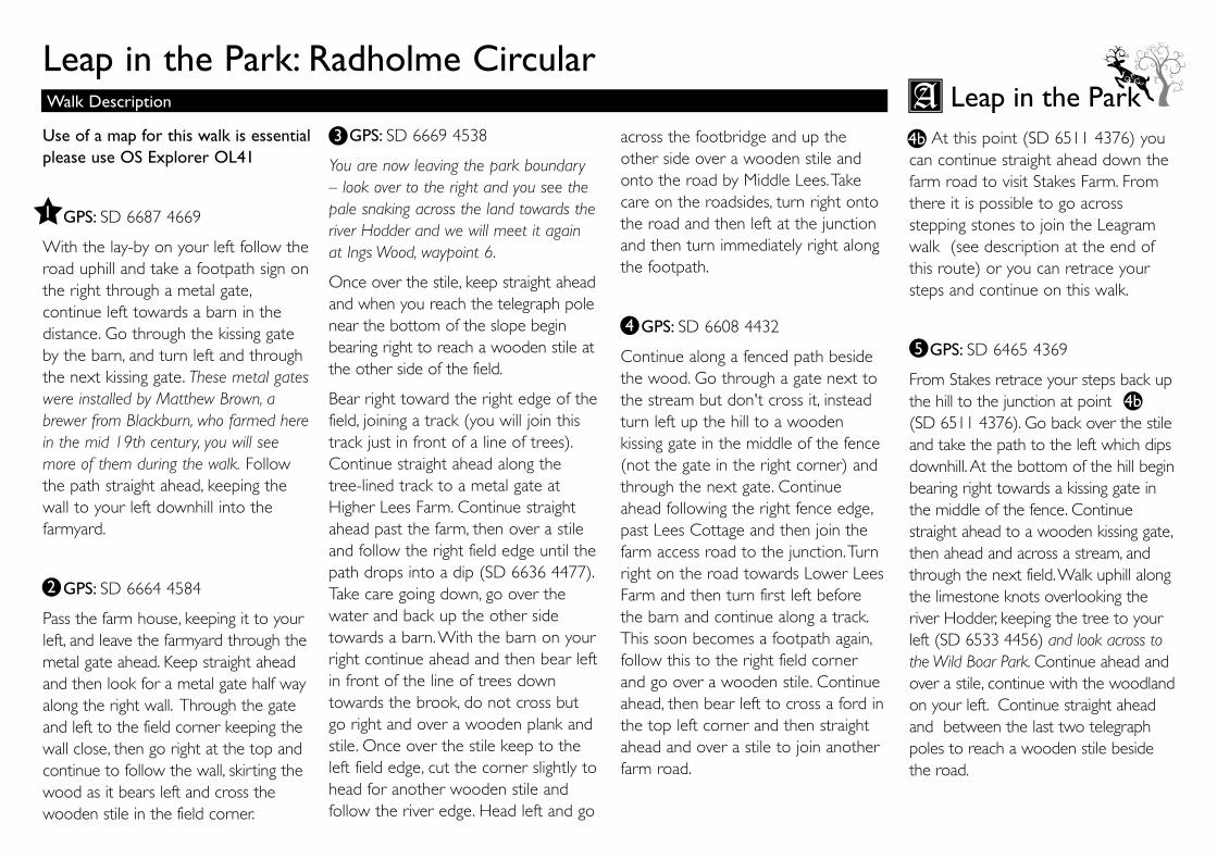
across the footbridge and up the other side over a wooden stile and onto the road by Middle Lees. Take care on the roadsides, turn right onto the road and then left at the junction and then turn immediately right along the footpath.
GPS: SD 6608 4432
Continue along a fenced path beside the wood. Go through a gate next to the stream but don't cross it, instead turn left up the hill to a wooden kissing gate in the middle of the fence (not the gate in the right corner) and through the next gate. Continue ahead following the right fence edge, past Lees Cottage and then join the farm access road to the junction. Turn right on the road towards Lower Lees Farm and then turn first left before the barn and continue along a track. This soon becomes a footpath again, follow this to the right field corner and go over a wooden stile. Continue ahead, then bear left to cross a ford in the top left corner and then straight ahead and over a stile to join another farm road.
At this point (SD 6511 4376) you can continue straight ahead down the farm road to visit Stakes Farm. From there it is possible to go across stepping stones to join the Leagram walk (see description at the end of this route) or you can retrace your steps and continue on this walk.
GPS: SD 6465 4369
From Stakes retrace your steps back up the hill to the junction at point (SD 6511 4376). Go back over the stile and take the path to the left which dips downhill. At the bottom of the hill begin bearing right towards a kissing gate in the middle of the fence. Continue straight ahead to a wooden kissing gate, then ahead and across a stream, and through the next field. Walk uphill along the limestone knots overlooking the river Hodder, keeping the tree to your left (SD 6533 4456) and look across to the Wild Boar Park. Continue ahead and over a stile, continue with the woodland on your left. Continue straight ahead and between the last two telegraph poles to reach a wooden stile beside the road.
Leap in the Park: Radholme Circular
Use of a map for this walk is essential please use OS Explorer OL41
GPS: SD 6687 4669
With the lay-by on your left follow the road uphill and take a footpath sign on the right through a metal gate, continue left towards a barn in the distance. Go through the kissing gate by the barn, and turn left and through the next kissing gate. These metal gates were installed by Matthew Brown, a brewer from Blackburn, who farmed here in the mid 19th century, you will see more of them during the walk. Follow the path straight ahead, keeping the wall to your left downhill into the farmyard.
GPS: SD 6664 4584
Pass the farm house, keeping it to your left, and leave the farmyard through the metal gate ahead. Keep straight ahead and then look for a metal gate half way along the right wall. Through the gate and left to the field corner keeping the wall close, then go right at the top and continue to follow the wall, skirting the wood as it bears left and cross the wooden stile in the field corner.
GPS: SD 6669 4538
You are now leaving the park boundary – look over to the right and you see the pale snaking across the land towards the river Hodder and we will meet it again at Ings Wood, waypoint 6.
Once over the stile, keep straight ahead and when you reach the telegraph pole near the bottom of the slope begin bearing right to reach a wooden stile at the other side of the field.
Bear right toward the right edge of the field, joining a track (you will join this track just in front of a line of trees). Continue straight ahead along the tree-lined track to a metal gate at Higher Lees Farm. Continue straight ahead past the farm, then over a stile and follow the right field edge until the path drops into a dip (SD 6636 4477). Take care going down, go over the water and back up the other side towards a barn. With the barn on your right continue ahead and then bear left in front of the line of trees down towards the brook, do not cross but go right and over a wooden plank and stile. Once over the stile keep to the left field edge, cut the corner slightly to head for another wooden stile and follow the river edge. Head left and go
1
2
Walk Description
3
4
4b
4b
5
Leap in the Park

The boundary of the deer park at Radholme is just under 10km in perimeter, and we believe that around half of this was provided by the River Hodder, running between Burholme and Lillyholme. The rest of the boundary was a pale – the bank and ditch of which shows up clearly in some places. The pale would likely to have been a wall on the high ground across Burholme Moor, and a fence on the lower lying land between Park Gate and Ing Wood. For further information about A Leap in the Park Project visit: www.forestofbowland.com/aleapinthepark
The Inn at Whitewell - In the 1300’s The Inn at Whitewell was just a small manor house, lived in by the keepers of the Royal forest. The Royal connection still remains as the Inn forms part of the Duchy of Lancaster Estate. It was not until comparatively recently, during the 1700’s, that the building was transformed into a resting place where travelers en route to or from Lancaster could safely stay before continuing their perilous journey. Today the Inn at Whitewell is an old fashioned rural Inn, welcoming to all, providing 23 bedrooms and serving fantastic local ingredients, the perfect spot to take a break during your walk. For further information visit www.innatwhitewell.com
Leap in the Park: Radholme Circular
GPS: SD 6582 4518
Turn left onto the road, taking extra care, and then take a right through a big metal gate opposite (there is a stile but it isn't usable). Notice Matthew Brown's gates: you are now back in the deer park! Turn left in the field and go through another metal gate, and then continue straight to go through a kissing gate in the wall ahead, slightly to the right. Continue straight ahead, climbing and keeping to the right field edge. Keep ahead and through a metal gate, then head for a stile in the middle of the field, and then to a final Matthew Brown metal kissing gate. Continue ahead, then turn left through the metal gate and bear right down a grassy track to Seed Hill. By the house join a track to the left and soon after bear left off it to reach a wooden gate and some steps down to the road. Turn left to go to downhill to the Inn at Whitewell.
GPS: SD 6591 4688
On leaving the Inn re trace your steps uphill past the social club and to the steps and wooden gate on your right. Go through the gate, up the track and turn right and then left to walk along the back of Seed Hill house. Follow the track between a line of trees and up the hill and through the metal gate.
GPS: SD 6627 4677
Continue uphill, keeping the knoll to your left and join a rough track to the brow of the hill. Curve around the right side of the knoll noticing the quarrying and large lime kiln on your left. Head through a metal gate which brings you out onto the road, turn left to get back to the lay-by.
Walk Description Leap in the Park7
8
www.forestofbowland.com/aleapinthepark
6
About This Walk
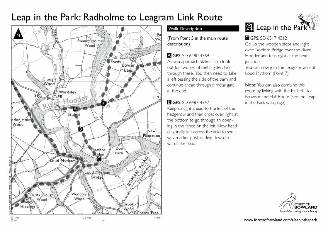
(From Point 5 in the main route description)
GPS: SD 6480 4369 As you approach Stakes farm look out for two set of metal gates. Go through these. You then need to take a left passing the side of the barn and continue ahead through a metal gate at the end.
GPS: SD 6487 4347Keep straight ahead to the left of the hedgerow and then cross over right at the bottom to go through an open-ing in the fence on the left. Now head diagonally left across the field to see a way marker post leading down to-wards the road.
GPS: SD 6517 4312Go up the wooden steps and right over Doeford Bridge over the River Hodder and turn right at the next junction.You can now join the Leagram walk at Loud Mythom (Point 7)
Note: You can also combine this route by linking with the Hall Hill to Browsholme Hall Route (see the Leap in the Park web page).
Leap in the Park: Radholme to Leagram Link RouteWalk Description Leap in the Park
A
B
www.forestofbowland.com/aleapinthepark
© C
row
n C
opyr
ight
. A
ll ri
ghts
res
erve
d (1
0002
3320
) (2
013)
N
0.5 Mile 1 Mile0 Miles0 Km 1 Km
C
C
A
B
5