Embed Size (px)
Citation preview

Learning About the Missouri River Project from Lewis and Clark Lesson materials for high school level created/developed by MOREnet/eMINTS instructional staff in support of the Lewis and Clark Historic Landscape Project conducted at the Geographic Resources Center (GRC), Department of Geography, University of Missouri, in partnership with the Missouri State Archives, Office of the Missouri Secretary of State. The Missouri Research and Education Network (MOREnet) provides Internet connectivity, access to Internet2, technical support, videoconferencing services and training to Missouri's K-12 schools, colleges and universities, public libraries, health care, state government and other affiliates. The eMINTS (enhancing Missouri’s Instructional Networked Teaching Strategies) program is an integral part of a statewide effort to move Missouri’s classrooms into the 21st century by combining cutting-edge technology with first-class teaching. MOREnet administers eMINTS under contract from the Missouri Department of Elementary and Secondary Education (DESE). Contents Lesson 1: Lewis and Clark Across Missouri
Student handout: Lewis and Clark Across Missouri Teacher’s Guide
Lesson 2: Lewis and Clark and the Missouri River Project Student handout: The Missouri River Project
©2003 Missouri Department of Elementary and Secondary Education (DESE) and Missouri Research and Education Network (MOREnet) The Curators of the University of Missouri. Materials may be duplicated/reproduced in hard copy format for use by educators and educational institutions. The copies may be used for noncommercial purposes only.

Title: Learning About the Missouri River Project from Lewis and Clark Subject Area: Social Studies-Geography Grade Level: 9-12 Show-Me Standards Social Studies Standard 2: Knowledge of continuity and change in the history of Missouri, the United States and the world. Social Studies Standard 5: The major elements of geographical study and analysis (such as location, place, movement, regions) and their relationships to changes in society and environment. MAP Performance Standards Goal 1.4 Use technological tools and other resources to locate, select and organize information. Goal 1.8 Organize data, information and ideas into useful forms (including charts, graphs, outlines) for analysis or presentation. Annotated Frameworks: (optional) Grade 11 Benchmarks 2.6: Missouri history as it relates to major development of U.S. history, to include:
• Exploration and settlement. 5.1: Knowledge of geographic research sources (e.g. maps, satellite images, gloves, charts, graphs and databases) and how to evaluate and use them:
• To interpret Earth’s physical and human systems; • To identify and solve geographic problems; • To construct maps.
5.2: Location: Students know how to communicate locations of places by creating maps and by describing their absolute locations and relative locations. Relationships within places: Students can explain how physical processes shape the earth’s surface. Time Allowance: This unit consists of two lessons.
• Lesson One: Approximately four 50-minute class periods, or two 90-minute class periods
• Lesson Two: Approximately four 50-minute class periods or two 90-minute class periods
Materials Needed: • At least one Internet-connected computer that can be displayed to the whole
class. A computer lab setting would be preferable. • Items as noted in for each lesson
Description: See following pages.

Title: Lewis and Clark Across Missouri
Subject Area: Social Studies Grade Level: 9 - 12 Show-Me Standards Social Studies Standard 2: Knowledge of continuity and change in the history of Missouri, the United States and the world. Social Studies Standard 5: The major elements of geographical study and analysis (such as location, place, movement, regions) and their relationships to changes in society and environment. MAP Performance Standards Goal 1.4 Use technological tools and other resources to locate, select and organize information. Goal 1.8 Organize data, information and ideas into useful forms (including charts, graphs, outlines) for analysis or presentation. Annotated Frameworks: (optional) Grade 11 Benchmarks 2.6: Missouri history as it relates to major development of U.S. history, to include:
• Exploration and settlement. 5.1: Knowledge of geographic research sources (e.g. maps, satellite images, gloves, charts, graphs, and databases) and how to evaluate and use them:
• To interpret Earth’s physical and human systems; • To identify and solve geographic problems; • To construct maps.
5.2: Location: Students know how to communicate locations of places by creating maps and by describing their absolute locations and relative locations. Relationships within places: Students can explain how physical processes shape the earth’s surface. Time Allowance: Approximately four 50-minute class periods, or two 90-minute class periods Materials Needed: CD: Don Henley, Inside Job - Goodbye to a River Lesson One Student Handout Lesson One Teacher Guide Internet-connected computers – Students could work in pairs. Blank paper for students to produce maps Description: In this lesson, students will develop map skills by using online interactive maps at the Web site: Lewis and Clark Across Missouri, http://lewisclark.geog.missouri.edu/index.shtml. They will follow a series of directions and answer questions as they explore the maps of the Missouri River. They will produce a graphic organizer using the information they obtain from the maps to compare the Missouri River as it is now to the river during the time of Lewis and Clark. They will form hypotheses about why these changes have occurred.

Activities: Hook: Goodbye to a River, Don Henley Play the song and/or read the lyrics. Discuss as a class group: What are the author’s views on the impact of man’s activities on a river? Might there be opposing viewpoints? What might they be? Is anyone right? Students will use the Student Handout, Lewis and Clark Across Missouri, to explore the Web site and to develop a graphic organizer of their choice to compare the Missouri River as it is today to the river as it was in the time of Lewis and Clark. When students have finished the Virtual River Travel Day activity bring them together as a class group to share their maps. First, place students in groups of four and have them share their maps with one another. They should look for similarities and differences in their drawings. Then, as a class, discuss the map-making activity. Some questions for discussion might include:
1. What difficulties did you experience in producing maps from the three dimensional image?
2. How did you determine which direction you were traveling? 3. What challenges do you think the Corps of Discovery experienced as they
produced maps of their expedition? 4. What questions do you have about how these maps were constructed by members
of the Corps? How detailed do you think these maps might be? At this point you might observe some of the maps developed by William Clark and Meriwether Lewis: http://www.pbs.org/lewisandclark/archive/idx_map.html This site also has maps and good explanations of their origin: http://www.loc.gov/exhibits/treasures/trr001.html After students finish the student handout, as a class group, discuss possible reasons for the changes in the river. Record student suggestions in a web or list that can be referred to in the next lesson. If students do not list the construction of dams and levees as a possible reason, return to the Landsat map of the Web site and have students search for potential reasons by observing the map. You might refer to the song Goodbye to a River and ask if there is any evidence of man’s activities on the map that the author references.

Student Handout Lewis and Clark Across Missouri http://lewisclark.geog.missouri.edu/index.shtml Introduction Lewis and Clark Across Missouri is a Web site built to commemorate the Bicentennial of the Lewis and Clark expedition. Using information from the Lewis and Clark journals and the 18th and 19th-century land survey notes along the Big River Corridors of the state of Missouri, the map developers have reconstructed the Missouri River showing how it looked at the time of the Lewis and Clark expedition. The site contains specific campsite maps, photo-realistic images of important river landmarks, animated virtual Missouri River travel, and an interactive map server offering layers of geographical data from the Expedition's outward and homeward journeys. This lesson is a tour designed to help you learn to navigate this Web site and to determine how the Missouri River has changed through time. Begin by loading the Web site URL into an Internet browser. Parts of the Web site 1. The Campsites From the homepage, click on the link for The Campsites found on the left-hand side of the page. This area of the Web site shows the location of the sites where the Corps of Discovery camped during the Lewis and Clark expedition. Take a minute to read the information on the introductory page. It explains how the campsite maps were developed. You may view the location maps of the campsites in Missouri for the outward journey by clicking on 1803-1804 campsites. You may find the return journey sites by clicking on 1806 campsites. Click on the 1803- 1804 campsites button. In the map that loads, red stars represent the campsites. Lewis and Clark established a camp along the Missouri River on June 12, 1804 (Starboard below a Round Bend). Visit this campsite. Use the legend to help you interpret the map. If you traveled today to the location of this camp, would it still be found on the banks of the Missouri? Explain. ________________________________________________________________ ________________________________________________________________ ________________________________________________________________ ________________________________________________________________

2. Virtual Landmarks Click on the link for Virtual Landmarks found on the left-hand side of the page. The information on this page describes how the virtual landmarks section of the Web site was constructed from historical data. Read this material then click Continue. Choose May 17, 1804 St. Charles, Missouri in the drop down menu at the top of the page. Observe the town of St. Charles and the Missouri River in 1804. Visit the Web site: http://infolink.cr.usgs.gov/Photos/MOTownGalleries/St.CharlesGallery/InternetFiles/index.htm At this site you can see current photos of St. Charles. What are the obvious differences between the two time periods? Are these differences surprising? ________________________________________________________________ ________________________________________________________________ ________________________________________________________________ ________________________________________________________________ ________________________________________________________________ 3. Virtual River Travel Day Click on the link for the Virtual River Travel Day found on the left-hand side of the page. Read the information and directions for using this area of the Web site. Click Continue. Choose one day of river travel and observe the trip taken by Lewis and Clark on that day. Notice that you may stop and start the map at any point along the trip by using the buttons at the bottom of the map. Meriwether Lewis created detailed maps of the areas the expedition traveled. Using the virtual river travel day feature, construct a map of the journey for the day of June 5, 1804. Complete your map on a sheet of 8 ½” by 11” white paper. You will not be able to determine the correct distance scale from the virtual tour. You can, however, diagram the major landmarks and the terrain. Don’t forget to include a key and a compass rose. 4. Interactive Map Server The Map Server is perhaps the most interesting and useful aspect of the Web site. Click on the Interactive Map Server link on the left-hand side of the page. You can choose a particular map by selecting one from the drop-down menu in the center of the page. Choose The Journey Begins 1803- 1804. Notice the set of tools on the upper left-hand corner of the map. Explore each of these tools and determine their use. Use the diagram below to develop a key with the name of the tool and a description of how and why to use each tool. Note: You may have to zoom in on the map to a close-up view for some of the tools to work.

The Query Tool is shown as an example. Key to the Map Legend Functions of the Legend Tools Query Tool This tool lets you search a database developed from information found in Lewis and Clark’s journals.
Query Tool

Layers Click on the Legend Tool in the tool bar. Notice that the information on the right-hand side of the map changes. Click on the legend tool until the Layers section is visible on the right. Zoom in on a portion of the map and notice how the options on the right-hand side of the map change. The closer you zoom, the more options you are given.
Each time you zoom in several things change: i. More layers are added and new features show up on the map. ii. The scale changes. iii. The Overview shows where the piece you are looking at fits into the
whole state. The layers represent the type of information found on the map. The checks in the square boxes on the left indicate which layers are visible. Try removing the check marks from the Hillshades layer. Now click the Refresh Map button. (You must click this button to make choices visible in the map.) Notice the difference in the map. Try adding and removing layers to determine the types of information that can be observed on the map. The round bullets just to the left of the layer names indicate the active layer. When using the query or find tools the correct layer must be chosen for the tool to locate the information you are looking for. Having the campsites layer active allows you to search references in the Lewis and Clark journals.

5. Using the Query, Find, and Information Tools: First make sure the Campsites layer is the active layer. Try using the Query, Find and Information tools to determine where deer were found on the trail. If you are having trouble using the Query tool follow these directions: Click on the Query Tool Icon. In the value box type deer. Click Add to Query String. Click Execute. Note: You may only use this tool one time. To initiate a second query, close the box and click on the Query Tool Icon. At how many campsites were deer observed? ________________________________________________________________ Which of the three search methods gave you the best results? ________________________________________________________________ ________________________________________________________________ Did you discover any helpful hints for using these tools? Explain at least one here. ________________________________________________________________ ________________________________________________________________ ________________________________________________________________ Try using the link at the bottom of the query and find boxes which says Zoom to These Records. Notice what happens when you click this link. Think about how this would have been helpful in locating the number of campsites where deer were observed. What is another animal encountered by Lewis and Clark while they traveled across Missouri? ________________________________________________________________ Did Lewis and Clark encounter any Native Americans while traveling across Missouri? ________________________________________________________________ 6. Measure Tool Use the measure tool to help you determine the following: How many miles per day did Lewis and Clark average on their journey between June 9th and June 26th? ____________________________________________

7. The Landsat Maps In the bottom right-hand corner of the Web site, choose Kansas Landsat from the drop-down menu. In the Layers section in the right-hand window, remove the check next to the Landsat 7 Near Infrared Layer and add a checkmark next to the Landsat 7 True Color Layer. Observe how the map changes. You may need to zoom in or out to view the map with this layer. You can see that a great deal of information might be gathered from this type of map. Use the Pan Tool to move the map to show the Kansas City area. Zoom into the area where Highway 435 crosses the location of the historic Missouri River. In this view you can see both the current Missouri River and the historic Missouri River layer. Look closely at this area of the map. Describe how this area of the Missouri River has changed from 1804 to the present. Give one hypothesis for what may have caused these changes in the river. You may find clues in the map itself. ________________________________________________________________ ________________________________________________________________ ________________________________________________________________ ________________________________________________________________ ________________________________________________________________ ________________________________________________________________ 8. Other Maps Take some time to explore the other maps found on the Interactive Map Server to determine what they contain and how they might be useful. 9. The Missouri River Then and Now Use the Lewis and Clark across Missouri Web site to compare the Missouri River as it was in the time of Lewis and Clark to the river today. Include in your comparison: changes in the course of the river, the flora and the fauna. The following Web site might help you find current flora and fauna: http://www.conservation.state.mo.us/nathis/. Make a graphic organizer to summarize your findings. You can use any organizer of your choice. Some possible examples might be a Venn diagram, an outline, a T diagram, a concept map or a web. You might also design an original type of organizer specifically for this task.

Scoring Guide: Virtual River Travel Day Map Student Name: Category Advanced Proficient Progressing Step One Labels At least 90% of
items labeled and located correctly.
80% of items labeled and located correctly.
70% of items labeled and located correctly.
Fewer than 70% labeled and located correctly.
Spelling/Cap All spelling and capitalization correct.
At least 90% of spelling and capitalization correct.
At least 80% of spelling and capitalization correct.
Less than 80% of spelling and capitalization correct.
Neatness All labels/features can be easily read.
Most labels/features can be easily read.
Some labels/features can be easily read.
Few labels/features can be easily read.
Title/Purpose Title clearly reflects purpose of map.
Title generally reflects purpose of map.
Title somewhat reflects purpose of map.
Title does not reflect purpose of map.
Key/Legend Has a key/legend that is readable and useful.
Has a key/legend and most symbols are useful.
Has a key/legend that is difficult to understand.
No key or legend that uses non-standard symbols.
Directions Map includes a compass rose and it is clear how to orient the map so that north is at the top.
Compass Rose or cardinal directions are marked on the map, but not both.
An attempt to place some cardinal directions on the map has been made, but it is not totally correct.
No cardinal directions are included on the map.
Information used to develop parts of this scoring guide were found at the Rubistar letter-writing rubric found at http://rubistar.4teachers.org.

Scoring Guide: The River Then and Now Student Name:
Category Advanced Proficient Progressing Step One Use of Graphic Organizer
An appropriate graphic organizer was chosen. The diagram clearly outlines the comparisons made.
Graphic organizer was used and most of the diagram clearly outlined the comparisons made; however, there were a few confusing areas.
Graphic organizer was used, but it did not clearly display the comparisons made. Information was unorganized and hard to follow.
No true graphic organizer was used. Information was just submitted in note or paragraph form.
Comparisons of the River’s Course
The present and historic rivers are thoroughly compared. Two specific examples of areas on the map that exemplify the changes are described.
The present and historic rivers are accurately compared. One specific example of areas on the map that exemplify the changes is described.
The present and historic rivers are compared but information is incomplete or inaccurate, or no examples are provided.
Course of the present and historic rivers are not compared.
Comparison of River Flora
The flora of the present and historic rivers is compared. At least three examples of differences are provided.
The flora of the present and historic rivers is compared. One or two examples of differences are provided.
The flora is compared in general terms, but no examples are given.
The flora of the present and historic rivers is not compared.
Comparison of River Fauna
The fauna of the present and historic rivers are compared. At least three examples of differences are provided.
The fauna of the present and historic rivers are compared. One or two examples of differences are provided.
The fauna are compared in general terms, but no examples are given.
The fauna of the present and historic rivers are not compared.
Neatness Graphic organizer is neatly done, attractive, and eye-catching. Material is typed or completed in another software program such as Inspiration.
Graphic organizer is neatly done, attractive, and eye-catching. Material is hand-written.
Most of the organizer is neatly done; however, part of the work is sloppy with a lack of organization.
Care was not taken. Organizer is hand-written and sloppy with a lack of organization.
Spelling
No misspelled words.
1-2 misspelled words.
3-4 misspelled words.
More than 4 misspelled words.
Information used to develop parts of this scoring guide were found at the Rubistar letter-writing rubric found at http://rubistar.4teachers.org.

Teacher Guide to Accompany the Student Handout Lewis and Clark Across Missouri http://lewisclark.geog.missouri.edu/index.shtml Lewis and Clark Across Missouri is a Web site built to commemorate the Bicentennial of the Lewis and Clark expedition. Using information from the Lewis and Clark journals and the 18th and 19th-century land survey notes along the Big River Corridors of the state of Missouri, the map developers have reconstructed the Missouri River at the time of the Lewis and Clark expedition. The site contains “specific campsite maps, photo-realistic images of important river landmarks, animated virtual Missouri River travel and an interactive map server offering various layers of geographical data on the Expedition's outward and homeward journeys.” This lesson is a tour designed to help you learn to navigate this Web site and to determine how the Missouri River has changed through time. You should begin by loading the Web site URL into an Internet browser. Tip: You may want to bookmark the site on students’ browsers ahead of time to save time during the lesson. If you have a class Web site, create a link to the site from your page or the media center or school could add it to a list of resources from the school site. Parts of the Web site The Campsites From the homepage, click on the link for The Campsites found on the left-hand side of the page. This area of the Web site shows the location of the sites where the Corps of Discovery camped during the Lewis and Clark expedition. Take a minute to read the information on the introductory page. It explains how the campsite maps were developed. You may view the location maps of the campsites in Missouri for the outward journey by clicking on 1803-1804 campsites. You may find the inward journey sites by clicking on 1806 campsites. Click on the 1803- 1804 campsites button. In the map that loads, red stars represent the campsites. Lewis and Clark established a camp along the Missouri River on June 12, 1804 (Starboard below a Round Bend). Visit this campsite. Use the legend to help you interpret the map. If you traveled today to the location of this camp, would it still be found on the banks of the Missouri? Explain.

ANSWER: No. The Missouri River has changed course since the days of Lewis and Clark. Today this campsite actually would be located about 5 miles west of present-day Glasgow, Mo. Virtual Landmarks Click on the link for Virtual Landmarks found on the left-hand side of the page. The information on this page describes how the virtual landmarks section of the Web site was constructed from historical data. Read this material and then click Continue. Choose May 17, 1804 St. Charles, Missouri in the drop down menu at the top of the page. Observe the town of St. Charles and the Missouri River in 1804. Visit the Web site: http://infolink.cr.usgs.gov/Photos/MOTownGalleries/St.CharlesGallery/InternetFiles/. At this site you can see current photos of St. Charles. Tip: You might show your students how to open two windows in their browser so they can view the two sites together. (In Internet Explorer, choose File > New > Window from the top menu bar. The windows can be resized to see both at once or students can move back and forth between windows by clicking on the tabs in the toolbar next to the Start button.) What are the obvious differences between the two time periods? Are these differences surprising? ANSWER: Most of these differences are not surprising. In the time of Lewis and Clark, St. Charles was a small village with just a few homes. Today it is actually a suburb of St. Louis. Along the river there are modern ships and bridges. However, you can see from the photographs that the river is much more narrow today than it was in the day of Lewis and Clark. This might be a surprising discovery for students. Virtual River Travel Day Click on the link for the Virtual River Travel Day found on the left-hand side of the page. Read the information and directions for using this area of the Web site. Click Continue. Choose one day of river travel and observe the trip taken by Lewis and Clark on that day. Notice that you can stop and start the map at any point along the trip by using the buttons at the bottom of the map. Meriwether Lewis created detailed maps of the areas the expedition traveled. Using the virtual river travel day, construct a map of the journey for the day of June 5th, 1804. Complete your map on a sheet of 8 ½” by 11” white paper. You will not be able to determine the correct distance scale from the virtual tour. You can, however, diagram the major landmarks and the terrain. Don’t forget to include a key and a compass rose.

Tip: See the Virtual River Map Scoring Guide. Students are provided with copies of the scoring guide in the student handout. Interactive Map Server The Map Server is perhaps the most interesting and useful aspect of the Web site. Click on the Interactive Map Server link on the left-hand side of the page. You can choose a particular map by selecting one from the drop-down menu in the center of the page. Choose The Journey Begins 1803- 1804. Notice the set of tools on the upper left-hand corner of the map. Explore each of these tools and determine their use. Use the diagram below to develop a key with the name of the tool and a description of how and why to use each tool. Note: You may have to zoom in on the map to a close-up view for some of the tools to work. The Query Tool is shown as an example.
Query Tool
Sample Answer: Query Tool This tool allows you to search a database developed from information from Lewis and Clarks’ journals.

ANSWERS TO TOOL KEY:
Legend/Layer List-This tool will switch the map between showing the legend and showing the layers.
Overview Map-This tool will make the overview map appear and disappear. We will do experiments with the overview later.
Zoom in and Zoom out-This map does some very magical things when you use the Zoom in and Zoom out tools. For now have the students try them just to experience the tools themselves.
Zoom to full extent and Zoom to Active Layer.
Return to last map size.
Pan-This hand can grab the map and drag it so you can view a different part of it.
Identify-This tool allows you to find out information about the active layer of the map.
Find-When clicked this tool will allow you to type in a keyword of something you would like to see on the map. When the Find window is open it will be indicated on the toolbar. If it disappears (hidden behind the map window) you can click Find on the toolbar and it will reappear.
Measure-This tool will allow you to measure distances on the map.
Clear Selection-This will clear anything that you have marked with the measuring tool so you can start over again.
Print-This tool will print the map you are looking at.
Help-Click this tool for instructions on using the map.

Layers Click on the Legend Tool in the tool bar. Notice that the information on the right-hand side of the map changes. Click on the legend tool until the Layers section is visible on the right. Zoom in on a portion of the map and notice how the options on the right-hand side of the map change. The closer you zoom, the more options you are given.
Each time you zoom in several things change: i. More layers are added and new features show up on the map. ii. The scale changes. iii. The Overview shows where the piece you are looking at fits into the
whole state. The layers represent the type of information found on the map. The checks in the square boxes on the left indicate which layers are visible. Try removing the check mark from the Hillshades layer. Now click the Refresh Map button. (You must click this button to make choices visible in the map.) Notice the difference in the map. Try adding and removing layers to determine the types of information that can be observed on the map. The round bullets just to the left of the layer names indicate the active layer. When using the query or find tools the correct layer must be chosen for the tool to locate the information you are looking for. Having the campsites layer active will allow you to search references in the Lewis and Clark journals.
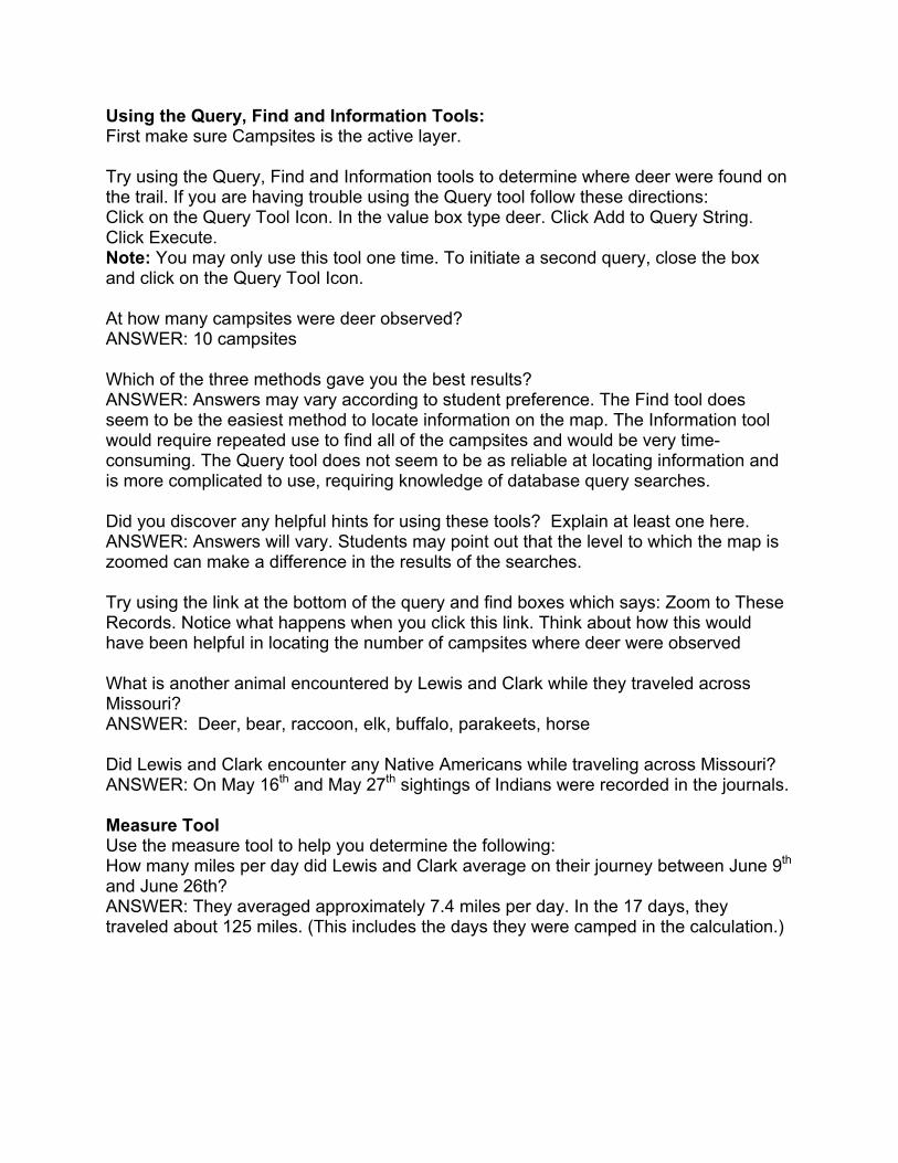
Using the Query, Find and Information Tools: First make sure Campsites is the active layer. Try using the Query, Find and Information tools to determine where deer were found on the trail. If you are having trouble using the Query tool follow these directions: Click on the Query Tool Icon. In the value box type deer. Click Add to Query String. Click Execute. Note: You may only use this tool one time. To initiate a second query, close the box and click on the Query Tool Icon. At how many campsites were deer observed? ANSWER: 10 campsites Which of the three methods gave you the best results? ANSWER: Answers may vary according to student preference. The Find tool does seem to be the easiest method to locate information on the map. The Information tool would require repeated use to find all of the campsites and would be very time-consuming. The Query tool does not seem to be as reliable at locating information and is more complicated to use, requiring knowledge of database query searches. Did you discover any helpful hints for using these tools? Explain at least one here. ANSWER: Answers will vary. Students may point out that the level to which the map is zoomed can make a difference in the results of the searches. Try using the link at the bottom of the query and find boxes which says: Zoom to These Records. Notice what happens when you click this link. Think about how this would have been helpful in locating the number of campsites where deer were observed What is another animal encountered by Lewis and Clark while they traveled across Missouri? ANSWER: Deer, bear, raccoon, elk, buffalo, parakeets, horse Did Lewis and Clark encounter any Native Americans while traveling across Missouri? ANSWER: On May 16th and May 27th sightings of Indians were recorded in the journals. Measure Tool Use the measure tool to help you determine the following: How many miles per day did Lewis and Clark average on their journey between June 9th and June 26th? ANSWER: They averaged approximately 7.4 miles per day. In the 17 days, they traveled about 125 miles. (This includes the days they were camped in the calculation.)

The Landsat Maps In the bottom right-hand corner of the Web site, choose Kansas Landsat from the drop-down menu. In the Layers section in the right-hand window, remove the check next to the Landsat 7 Near Infrared Layer and add a checkmark next to the Landsat 7 True Color Layer. Observe how the map changes. You may need to zoom in or out to view the map with this layer. You can see that a great deal of information might be gathered from this type of map. Use the Pan Tool to move the map to show the Kansas City area. Zoom into the area where Highway 435 crosses the location of the historic Missouri River. In this view you can see both the current Missouri River and the historic Missouri River layer. Look closely at this area of the map. Describe how this area of the Missouri River has changed from 1804 to the present. Give one hypothesis for what may have caused these changes in the river. You may find clues in the map itself. ANSWER: The Missouri river today is much narrower and has fewer branches than that found in the day of Lewis and Clark. It is much more like a channel. The river had an island in this area during the time of Lewis and Clark that is no longer visible. There are no wrong or right answers to the hypotheses. Students might describe geological events like erosion or flooding that may have changed the course of the river. The Landsat maps are actually satellite images of the area and show quite a lot of detail. If students are observant, the levees around the edge of the river can be observed. This would lead them to conclude the changes to the river were probably man-made. Other Maps Take some time to explore the other maps found on the Interactive Map Server to determine what they contain and how they might be useful. The Missouri River Then and Now Use the Lewis and Clark across Missouri Web site to compare the Missouri River as it was in the time of Lewis and Clark to the River today. Include in your comparison changes in the course of the river, the flora and the fauna. The following Web site might help you find current flora and fauna: http://www.conservation.state.mo.us/nathis/ Make a graphic organizer to summarize your findings. You can use any organizer of your choice. Some possible examples might be a Venn diagram, an outline, a T diagram, a concept map or a web. You might also design an original type of organizer specifically for this task. Tip: See the Missouri River Then and Now Scoring Guide. Students are provided with a copy of the scoring guide in the student handout.

Virtual River Travel Day Map Scoring Guide
Student Name: Category Advanced Proficient Progressing Step One Labels At least 90% of
items labeled and located correctly.
80% of items labeled and located correctly.
70% of items labeled and located correctly.
Fewer than 70% labeled and located correctly.
Spelling/Cap All spelling and capitalization correct.
At least 90% of spelling and capitalization correct.
At least 80% of spelling and capitalization correct.
Less than 80% of spelling and capitalization correct.
Neatness All labels/features can be read easily.
Most labels/features can be read easily.
Some labels/features can be read easily.
Few labels/features can be read easily.
Title/Purpose Title clearly reflects purpose of map.
Title generally reflects purpose of map.
Title somewhat reflects purpose of map.
Title does not reflect purpose of map.
Key/Legend Has a key/legend that is readable and useful.
Has a key/legend and most symbols are useful.
Has a key/legend that is difficult to understand.
No key or legend that uses non-standard symbols.
Directions Map includes a compass rose and it is clear how to orient the map so that north is at the top.
Compass Rose or cardinal directions are marked on the map, but not both.
An attempt to place some cardinal directions on the map has been made, but it is not totally correct.
No cardinal directions are included on the map.
Information used to develop parts of this scoring guide were found at the Rubistar letter-writing rubric found at http://rubistar.4teachers.org.

The River Then and Now Scoring Guide Student Name:
Category Advanced Proficient Progressing Step One Use of Graphic Organizer
An appropriate graphic organizer was chosen. The diagram clearly outlines the comparisons made.
Graphic organizer was used and most of the diagram clearly outlined the comparisons made; however, there were a few confusing areas.
Graphic organizer was used, but it did not clearly display the comparisons made. Information was unorganized and hard to follow.
No true graphic organizer was used. Information was just submitted in note or paragraph form.
Comparisons of the River’s Course
The present and historic rivers are thoroughly compared. Two specific examples of areas on the map that exemplify the changes are described.
The present and historic rivers are accurately compared. One specific example of areas on the map that exemplify the changes is described.
The present and historic rivers are compared but information is incomplete or inaccurate or no examples are provided.
Course of the present and historic rivers are not compared.
Comparison of River Flora
The flora of the present and historic rivers is compared. At least three examples of differences are provided.
The flora of the present and historic rivers is compared. One or two examples of differences are provided.
The flora is compared in general terms, but no examples are given.
The flora of the present and historic rivers is not compared.
Comparison of River Fauna
The fauna of the present and historic rivers are compared. At least three examples of differences are provided.
The fauna of the present and historic rivers are compared. One or two examples of differences are provided.
The fauna are compared in general terms, but no examples are given.
The fauna of the present and historic rivers are not compared.
Neatness Graphic organizer is neatly done, attractive and eye-catching. Material is typed or completed in another software program such as Inspiration.
Graphic organizer is neatly done, attractive and eye-catching. Material is hand-written.
Most of the organizer is neatly done; however, part of the work is sloppy with a lack of organization.
Care was not taken. Organizer is hand-written and sloppy with a lack of organization.
Spelling
No misspelled words.
1-2 misspelled words.
3-4 misspelled words.
More than 4 misspelled words.
Information used to develop parts of this scoring guide were found at the Rubistar letter-writing rubric found at http://rubistar.4teachers.org.

Title: Lewis and Clark and the Missouri River Project Subject Area: Social Studies Grade Level: 9 - 12 Show-Me Standards Social Studies Standard 2: Knowledge of continuity and change in the history of Missouri, the United States and the world. Social Studies Standard 5: The major elements of geographical study and analysis (such as location, place, movement, regions) and their relationships to changes in society and environment. MAP Performance Standards Goal 1.4 Use technological tools and other resources to locate, select and organize information. Goal 1.8 Organize data, information and ideas into useful forms (including charts, graphs, outlines) for analysis or presentation. Annotated Frameworks: (optional) Grade 11 Benchmarks 2.6: Missouri history as it relates to major development of U.S. history, to include:
• Exploration and settlement. 5.1: Knowledge of geographic research sources (e.g. maps, satellite images, gloves, charts, graphs and databases) and how to evaluate and use them:
• To interpret Earth’s physical and human systems; • To identify and solve geographic problems; • To construct maps.
5.2: Location: Students know how to communicate locations of places by creating maps and by describing their absolute locations and relative locations. Relationships within places: Students can explain how physical processes shape the earth’s surface. Time Allowance: Approximately four 50-minute class periods or two 90-minute class periods Materials Needed:
• Lesson Two Student Handout • Internet-connected computers – It would be best to have computers available for
the class. Students could work in pairs Description: In this lesson, students will research the Missouri River Restoration Project; they will determine pros and cons of the project. They will then research the lives of Lewis and Clark. They will use this research and the information they learned about the Missouri River in Lesson One from using the interactive maps in the Lewis and Clark Across Missouri Web site to write a letter to the U.S. Army Corps of Engineers in the person of Meriwether Lewis or William Clark. They will express the views of one of the explorers on the changes that have occurred in the river and the river restoration project.

Activities: In Lesson Two students will research the Missouri River Restoration Project to determine what the project involves and what viewpoints exist about the project. They will then research the lives of Meriwether Lewis and William Clark. Students will choose one of these two historic figures and decide how they would respond to the Missouri River Restoration Project. Would they be in favor of the project? Students will write a letter to the Army Corps of Engineers in the person of either Lewis or Clark. In this letter they should use the information gathered from the maps to explain how the river has changed since the time of their expedition, whether the river should be restored and why they (in the person of Lewis or Clark) believe as they do. Student directions for this lesson are found on the Student Handout: The Missouri River Project. Students may be placed in cooperative groups and different parts of the research assigned to different group members. Roles might be divided as follows:
• River Navigator: researches the changes that have occurred in the river and the causes of the changes.
• River Restoration Expert: researches the proposed river restoration solutions. • River Debate Expert: researches the pros and cons of the river restoration. • History Buff: researches the life either of Meriwether Lewis or William Clark.
After working individually on the research or with a partner from another group who has the same task (jigsaw grouping), students should return to their groups to share their information. Each individual in the group is responsible for creating his/her own letter.

Student Handout The Missouri River Restoration Project Introduction Currently a debate is occurring all along the Missouri River. The environmental group, American Rivers, recently named the Missouri River as America’s Most Endangered River. The U. S. Fish and Wildlife Service has made several recommendations to the United States Corps of Engineers in an attempt to restore the river habitat and wildlife. The Corps of Engineers controls the flow of the Missouri River using a series of man-made dams. Based on the Fish and Wildlife recommendations, the Corps proposed a potential solution to the environmental problems of the Missouri River and developed the Missouri River Restoration Project. This proposed project has stirred much debate among environmentalists and persons who live along the river. In June 2002 the Bush administration postponed the plans for altering the river’s flow. And the debate continues . . . . Use the Web sites provided in this handout to research issues surrounding the restoration of the Missouri River. Questions to Answer What problems have caused the Missouri River to be named America’s most endangered river? What are the reasons for these problems? What changes are being proposed by the U.S. Fish and Wildlife Service and the Army Corps of Engineers to solve these environmental problems? Develop a graphic organizer of your choice to summarize the varying viewpoints held by persons along the Missouri River, as well as the pros and cons of the restoration project.

Resources Notice that many of these Web sites are published by organizations that hold a particular viewpoint. Take this into consideration as you complete your research. American Rivers: Saving the Missouri River http://www.amrivers.org/missouririver/background.htm Discovering the Rivers of Lewis and Clark http://www.amrivers.org/lewisclark/exhibit1.htm Another part of the American Rivers Web site U.S. Army Corps of Engineers Missouri River Master Manual http://www.nwd-mr.usace.army.mil/mmanual/mast-man.htm This site contains information about the Corps’ restoration proposal. The Corps held hearings at locations up and down the Missouri River to gather public opinion about the restoration proposal. Click on the hearing transcripts to read viewpoints of persons who attended these meetings. USGS Missouri River InfoLink http://infolink.cr.usgs.gov/ Also see the Missouri River Story for information on how the river has been changed: http://infolink.cr.usgs.gov/The_River/. The Big Muddy Blues (Kansas City Star News Article) http://www.kcstar.com/standing/river/ Fact Monster: Missouri River http://www.factmonster.com/ce6/us/A0833425.html The Missouri River http://web.bryant.edu/~langlois/ecology/index1.html This site includes information about the animals, history, actions, reservoirs and threats to the Missouri River. Exploring the Lives of Lewis and Clark Use the resources below to research the life of Meriwether Lewis or William Clark. What occupations did they hold? Were they married? Have children? What type of persons were they? Use this information to decide how the explorer you chose would feel about restoring the Missouri River. If Meriwether Lewis or William Clark were to return to Missouri today, would he support the restoration of the river? You should have information about the explorer to back up your decision. Use your research to fill in the chart on the next pages.

Exploring the Lives of Lewis and Clark Explorer Chosen: ____________________________________ Notes about explorer’s personal life: Would this explorer support the Missouri River Restoration? What evidence have you gathered that led you to this conclusion?

Resources The Lewis and Clark Expedition http://www.lewis-clark.org/index.htm This fairly complex Web site has a lot of information you will need. In the left navigation bar under Discovery Paths choose The Corps. This will give you information about Lewis and Clark as people! Also look at the journal entries on various days. Reading them can give insight into the personalities of Lewis and Clark. Meriwether Lewis: Explorer http://www.lucidcafe.com/library/95aug/lewis.html PBS: The West Meriwether Lewis http://www.pbs.org/weta/thewest/people/i_r/lewis.htm PBS: The West William Clark http://www.pbs.org/weta/thewest/people/a_c/clark.htm Meriwether Lewis: Biography http://www.nps.gov/jeff/LewisClark2/CorpsOfDiscovery/TheLeaders/Lewis/Lewis.htm William Clark: Biography http://www.nps.gov/jeff/LewisClark2/CorpsOfDiscovery/TheLeaders/Clark/Clark.htm A Letter to the Corps of Engineers Now you will put together the information you have learned from the Lewis and Clark Across Missouri maps and your Internet research. Here is your challenge: Pretend you are Meriwether Lewis or William Clark and you have returned to Missouri in the year 2003. You visit the Missouri River to observe the changes there. You learn about the restoration project being debated. You write a letter to the U.S Army Corps of Engineers that includes the following:
• Using the information from the Lewis and Clark across Missouri Web site and your research, briefly describe the changes that have occurred in the river since you saw it in the early 1800s.
• Describe how you feel about the restoration project. Should the Corps proceed with this project as planned?
• Why do you feel this way? (This section should show that you have researched the life of the explorer you are representing and have made a logical decision about why this explorer would make the decision he has. It should also reflect your research on the pros and cons of the restoration project.)

Scoring Guide: A Letter to the Corps of Engineers Student Name:
Category Advanced Proficient Progressing Step One River Changes Letter accurately
and thoroughly summarizes changes to the Missouri River including river’s course, fauna, flora and other areas found in research.
Letter accurately summarizes changes to the Missouri River including river’s course, with references to the flora and fauna.
Letter summarizes the changes to the river, but is missing some vital aspects of the changes or some of the information is inaccurate.
Summary of river changes is totally inaccurate or unavailable.
Lewis or Clark Viewpoint
Lewis or Clark’s viewpoint of the river restoration project is clearly and thoroughly stated.
Lewis or Clark’s viewpoint of the river restoration project is described but lacks some explanation and supporting detail.
Lewis or Clark’s viewpoint on the river restoration is not thoroughly developed, is unclear or is not logical.
The viewpoint of the river restoration project is not addressed.
Supporting Evidence for Viewpoint
Viewpoint is supported with appropriate information from lives of Lewis or Clark with information on pros and cons of the river restoration project.
Viewpoint is supported with appropriate information from lives of Lewis or Clark with information on the pros and cons of the river restoration, but not both.
Viewpoint is incompletely supported or the supporting details provided are partially inaccurate or do not lend support to the viewpoint.
Viewpoint is not supported with research.
Voice Letter is written in the voice of Lewis or Clark. Research of the explorer’s life is cleverly meshed into the letter’s message.
Letter is written in the voice of Lewis or Clark. Research is included, but does not blend seamlessly into the letter’s message. Research seems tacked on to information in the letter.
Letter is written in the voice of Lewis or Clark, but there is no evidence of research of the explorer’s life.
No attempt was made to write the letter in the voice of Lewis or Clark.

Category Advanced Proficient Progressing Step One Capitalization and Punctuation
Writer makes no errors in capitalization or punctuation.
Writer makes 1-2 errors in capitalization or punctuation.
Writer makes 3-4 errors in capitalization or punctuation.
Writer makes more than 4 errors in capitalization or punctuation.
Format Complies with all the requirements for a professional letter.
Complies with almost all the requirements for a professional letter.
Complies with several of the requirements for a professional letter.
Complies with less than 75% of the requirements for a professional letter.
Neatness Letter is typed, clean, not wrinkled and is easy to read with no distracting error/corrections. It was done with pride.
Letter is neatly hand-written, not wrinkled and is easy to read with no distracting error/corrections. It was done with care.
Letter is typed and is crumbled or slightly stained. It may 1-2 distracting error/corrections. It was done with some care.
Letter looks like it has been shoved in a pocket or locker. It may have several distracting error/corrections. It looks like it was done in a hurry or stored improperly.
Information used to develop parts of this scoring guide were found at the Rubistar letter-writing rubric found at http://rubistar.4teachers.org.