Embed Size (px)
Citation preview

Lee Highway
Planning Initiative
Community Open House
November 29, 2016
Department of Community Planning,
Housing and Development
1

Welcome
2
Thank you for joining us today!
Purpose of today’s check-in
Preparing to kick-off a community planning process
for Lee Highway in 2017
Sharing preliminary ideas• Study area
• Planning elements
• Role of Visioning Study
• Outcomes/Milestones
• Considerations/expectations
Gathering input on the scope of the future study

KICK-OFF
Early 2017
County Board adopts scope and charge
December/January
Key Tasks• Refine scope, process,
and schedule
• Define and draft charge for stakeholder group(s)
• If needed, draft and issue request for proposal for consultant services
May Nov/Dec
BIG IDEAS (major scope
elements)shared for
input
June - October
Key Tasks• Convened
interdepartmental team
• Met with steering group
• Drafted preliminary big ideas for scope and process, including major scope elements
Lee Highway Visioning
Report
3
Schedule: Pre-Planning Process

4
Big Ideas
1. Where do we start? Build off the the community’s Visioning Study
2. What type of plan do we need?As the first plan for Lee Highway, the five-mile long corridor
would benefit from a comprehensive, high-level vision
3. What needs the most focus?Commercial, multi-family areas that have not been studied
previously are in most need of a vision
4. How do we get there?A multi-year effort, engaging stakeholders at a variety of
levels, will involve key steps to validate the vision, define
character areas, evaluate scenarios, develop the framework,
and identify tools. Consultant expertise will be needed.

5
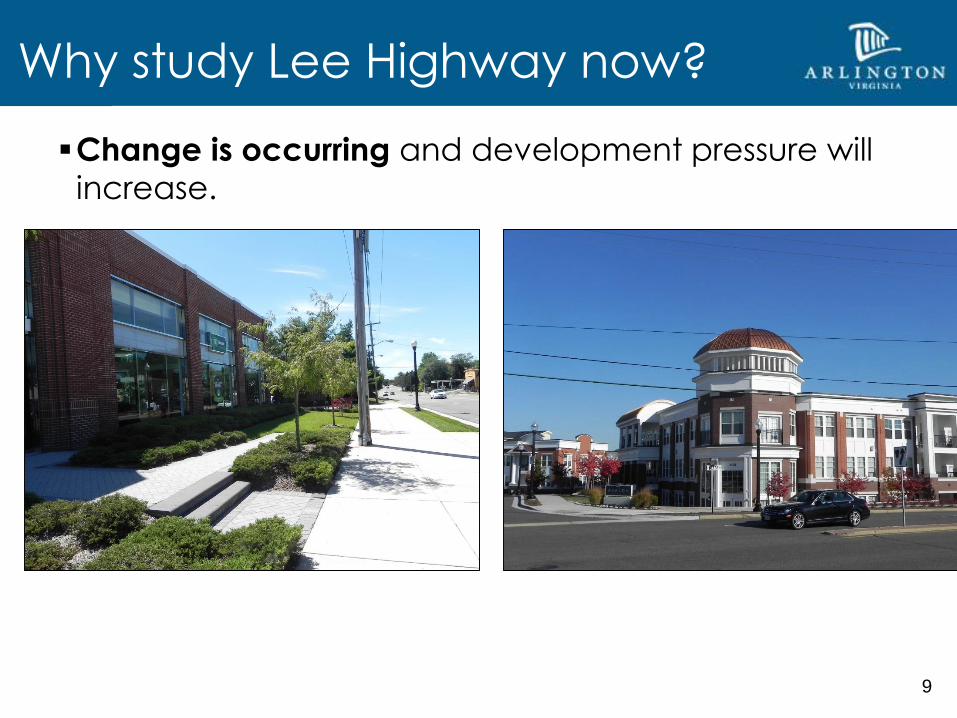
Why study Lee Highway now?
Grassroots effort spearheaded by Lee Highway Alliance
(LHA) resulted in Visioning Study
LHA currently working to formalize as a nonprofit
organization
The County Board requested that staff develop a scope
and process in order to kick-off a formal planning
process in early 2017.

6
Why study Lee Highway now?
5-mile long, VDOT-controlled corridor
18 civic associations

7
Why study Lee Highway now?
The corridor plays an important role as the main street
for the County’s northern neighborhoods and is distinct
in character from the County’s Metro corridors.

8
Why study Lee Highway now?
Mix of commercial and multi-family development with
adjacent single-family neighborhoods, mostly built by-
right
Approximately 1,700 market rate affordable units
9
Why study Lee Highway now?
Change is occurring and development pressure will
increase.

10
Why study Lee Highway now?
We don’t have a comprehensive plan for the corridor
Two areas previously studied: Cherrydale (1994) and East
Falls Church (2011)
11
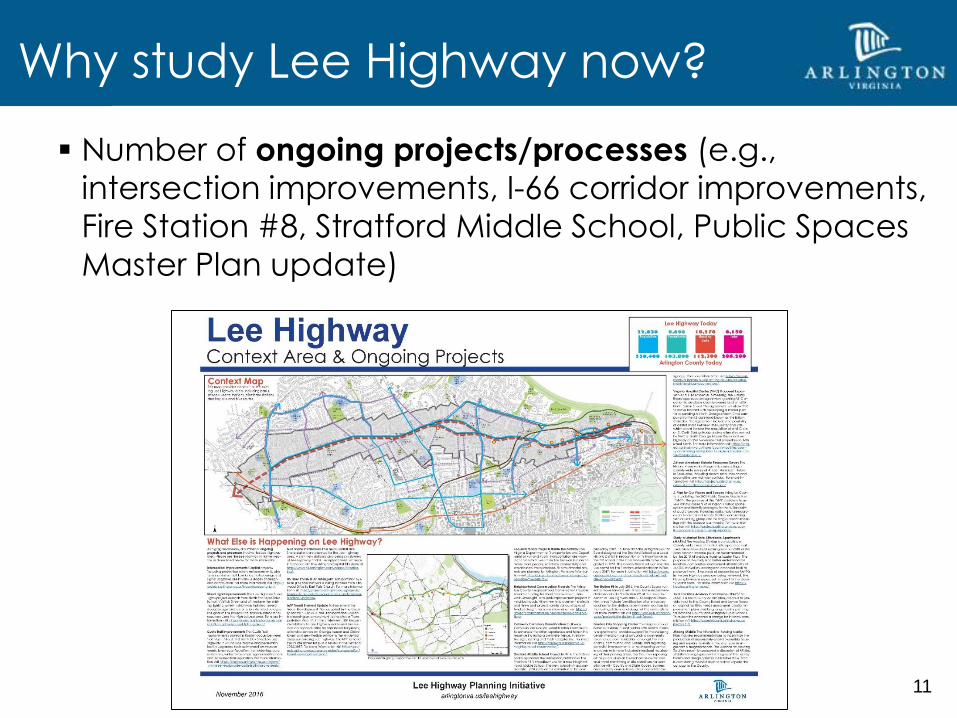
Why study Lee Highway now?
Number of ongoing projects/processes (e.g.,
intersection improvements, I-66 corridor improvements,
Fire Station #8, Stratford Middle School, Public Spaces
Master Plan update)

12
First corridor plan for Lee Highway; County’s other
major corridors are guided by an overarching
framework (Rosslyn-Ballston, Columbia Pike)
Effectively manage the large geography and
engage the communityo Need to understand corridor-wide elements
o Large number of impacted stakeholders
o Potential for fatigue if the process takes too long
Need to consider time and resources
VDOT-controlled commuter corridor; National
Highway System status; constrained right-of-way
width
Considerations in Drafting the Scope

13
Some areas have common characteristics and may
benefit from shared strategies:
o Large parcels at key intersections; consolidation likely
o Small, shallower parcels in between, with multiple owners
and long-standing businesses
Change will take time and require private and public
investment
Ensure a vision that will work over time, for both
revitalization and redevelopment
Get to implementation tools sooner
Considerations in Drafting the Scope

What kind of plan do we need?
14
Establish a comprehensive, high-level vision for the corridor
Provide a general vision with goals, objectives, and recommendations
for key planning elements, including land use, building height and
form, open space, and transportation/connectivity improvements for
the corridor
Identify and prioritize implementation tools
What type of plan do we need?
Columbia Pike Initiative (2005) RB72

How do we get there?
15
Education, preliminary research &
analysis
Validate and refine the vision
Define general character areas (e.g.,
redevelopment, revitalization and
conservation)
Evaluate land use scenarios
Develop a corridor plan and
recommendations
Identify implementation tools
Adopt the plan
Develop implementation tools
Mu
ltiy
ea
r p
roc
ess
Key Planning Elements to Be Included
Land Use
Housing
Transportation and Connectivity
Parks and Open Space
Building Form, Height and Urban Design
Historic Preservation, Cultural Resources,
Art
Economic Vitality
Sustainability
Public Facilities: Schools, Community
Centers and Libraries, Operations, Other
facilities
Key Stakeholders to be engaged at different
times throughout the process
• Civic Associations
• Lee Highway Alliance
• Property Owners
• Businesses
• Focus groups
• School community groups
• Commissions/Advisory Groups

16
Planning Area
– Areas within 1/4-mile walking distance of the corridor
– Primary research area
– Develop a vision and recommendations for network-wide
elements, such as transportation and open space
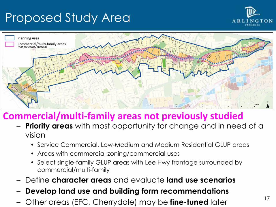
Proposed Study Area
Similar to other planning areas on the General Land Use Plan, such as the
Rosslyn-Ballston corridor or Columbia Pike
Planning Area
17
– Priority areas with most opportunity for change and in need of a
vision• Service Commercial, Low-Medium and Medium Residential GLUP areas
• Areas with commercial zoning/commercial uses
• Select single-family GLUP areas with Lee Hwy frontage surrounded by
commercial/multi-family
– Define character areas and evaluate land use scenarios
– Develop land use and building form recommendations
– Other areas (EFC, Cherrydale) may be fine-tuned later
Commercial/multi-family areas not previously studied
Proposed Study Area
Planning Area
Commercial/multi-family areas(not previously studied)

18
Residential edges– Need to be considered in terms of impacts from adjacent
redevelopment and/or to make redevelopment feasible on Lee
Highway
– Single-family areas adjacent to shallow lots in commercial/multi-
family areas
– Capture approximately 250 feet from Lee Hwy and arterial streets
– Opportunity to explore housing types that transition appropriately to single-family neighborhoods
Proposed Study Area
Planning Area
Commercial/multi-family areas
Residential Edges
(not previously studied)

Summary
Big Ideas for Feedback
– Build off the Visioning Study
– A high-level plan would best manage the large
geography in an efficient timeframe and get to
the implementation tools
– Commercial/multi-family areas will have the
most focus; EFC/Cherrydale may be fine-tuned
in the future
– The study will be informed by ongoing
projects/processes
19
Thank You
Review the boards, talk with staff,
and fill out the questionnaire
Materials and survey are
available online until Dec. 9th –
spread the word!
Questions/More info
– Visit:
arlingtonva.us/leehighway
– Email: [email protected]
20
Next Steps
Review feedback and refine scope
Draft ideas for civic engagement
Contract with consultants
Kick-off process with County Board charge