Embed Size (px)
Citation preview
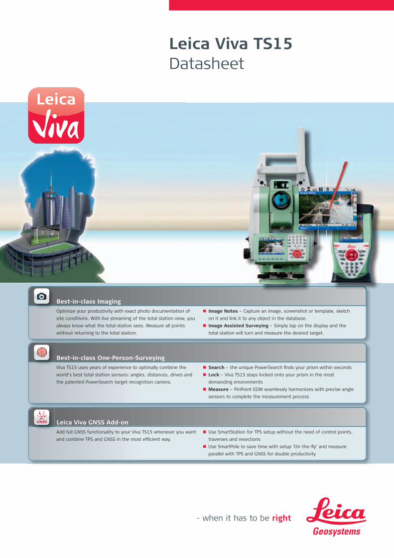
Leica Viva TS15 Datasheet
Optimize your productivity with exact photo documentation of
site conditions. With live streaming of the total station view, you
always know what the total station sees. Measure all points
without returning to the total station.
Image Notes – Capture an image, screenshot or template, sketch
on it and link it to any object in the database.
Image Assisted Surveying – Simply tap on the display and the
total station will turn and measure the desired target.
Best-in-class Imaging
Viva TS15 uses years of experience to optimally combine the
world’s best total station sensors: angles, distances, drives and
the patented PowerSearch target recognition camera.
Search – the unique PowerSearch fi nds your prism within seconds
Lock – Viva TS15 stays locked onto your prism in the most
demanding environments
Measure – PinPoint EDM seamlessly harmonizes with precise angle
sensors to complete the measurement process
Best-in-class One-Person-Surveying
Add full GNSS functionality to your Viva TS15 whenever you want
and combine TPS and GNSS in the most effi cient way.
Use SmartStation for TPS setup without the need of control points,
traverses and resections
Use SmartPole to save time with setup ‘On-the-fl y’ and measure
parallel with TPS and GNSS for double productivity
Leica Viva GNSS Add-on
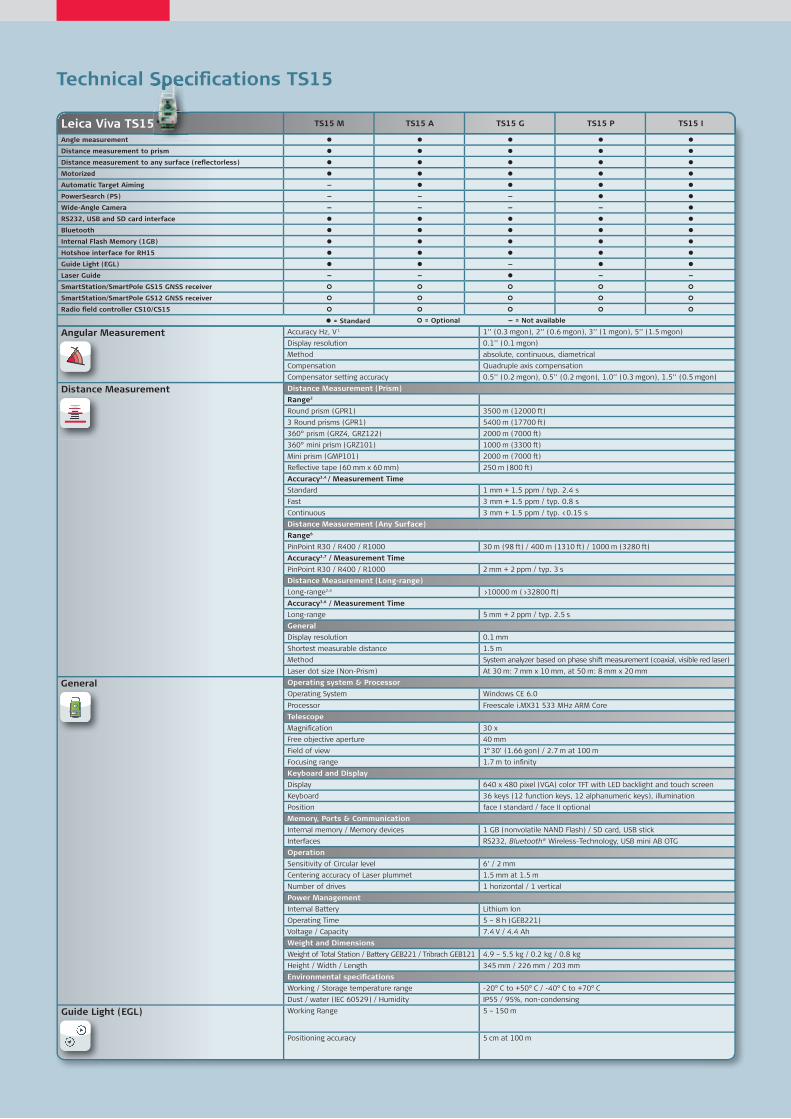
Technical Specifi cations TS15
Leica Viva TS15 TS15 M TS15 A TS15 G TS15 P TS15 I
Angle measurement
Distance measurement to prism
Distance measurement to any surface (refl ectorless)
Motorized
Automatic Target Aiming —
PowerSearch (PS) — — —
Wide-Angle Camera — — — —
RS232, USB and SD card interface
Bluetooth
Internal Flash Memory (1GB)
Hotshoe interface for RH15
Guide Light (EGL) —
Laser Guide — — — —
SmartStation/SmartPole GS15 GNSS receiver
SmartStation/SmartPole GS12 GNSS receiver
Radio fi eld controller CS10/CS15
= Standard — = Not available = Optional
Angular Measurement Accuracy Hz, V 1 1’’ (0.3 mgon), 2’’ (0.6 mgon), 3’’ (1 mgon), 5’’ (1.5 mgon)
Display resolution 0.1’’ (0.1 mgon)
Method absolute, continuous, diametrical
Compensation Quadruple axis compensation
Compensator setting accuracy 0.5’’ (0.2 mgon), 0.5’’ (0.2 mgon), 1.0’’ (0.3 mgon), 1.5’’ (0.5 mgon)
Distance Measurement Distance Measurement (Prism)
Range2
Round prism (GPR1) 3500 m (12000 ft)
3 Round prisms (GPR1) 5400 m (17700 ft)
360° prism (GRZ4, GRZ122) 2000 m (7000 ft)
360° mini prism (GRZ101) 1000 m (3300 ft)
Mini prism (GMP101) 2000 m (7000 ft)
Refl ective tape (60 mm x 60 mm) 250 m (800 ft)
Accuracy3,4 / Measurement Time
Standard 1 mm + 1.5 ppm / typ. 2.4 s
Fast 3 mm + 1.5 ppm / typ. 0.8 s
Continuous 3 mm + 1.5 ppm / typ. <0.15 s
Distance Measurement (Any Surface)
Range6
PinPoint R30 / R400 / R1000 30 m (98 ft) / 400 m (1310 ft) / 1000 m (3280 ft)
Accuracy3,7 / Measurement Time
PinPoint R30 / R400 / R1000 2 mm + 2 ppm / typ. 3 s
Distance Measurement (Long-range)
Long-range2,4 >10000 m (>32800 ft)
Accuracy3,6 / Measurement Time
Long-range 5 mm + 2 ppm / typ. 2.5 s
General
Display resolution 0.1 mm
Shortest measurable distance 1.5 m
Method System analyzer based on phase shift measurement (coaxial, visible red laser)
Laser dot size (Non-Prism) At 30 m: 7 mm x 10 mm, at 50 m: 8 mm x 20 mm
Operating system & Processor
Operating System Windows CE 6.0
Processor Freescale i.MX31 533 MHz ARM Core
Telescope
Magnifi cation 30 x
Free objective aperture 40 mm
Field of view 1° 30’ (1.66 gon) / 2.7 m at 100 m
Focusing range 1.7 m to infi nity
Keyboard and Display
Display 640 x 480 pixel (VGA) color TFT with LED backlight and touch screen
Keyboard 36 keys (12 function keys, 12 alphanumeric keys), illumination
Position face I standard / face II optional
Memory, Ports & Communication
Internal memory / Memory devices 1 GB (nonvolatile NAND Flash) / SD card, USB stick
Interfaces RS232, Bluetooth® Wireless-Technology, USB mini AB OTG
Operation
Sensitivity of Circular level 6’ / 2 mm
Centering accuracy of Laser plummet 1.5 mm at 1.5 m
Number of drives 1 horizontal / 1 vertical
Power Management
Internal Battery Lithium Ion
Operating Time 5 – 8 h (GEB221)
Voltage / Capacity 7.4 V / 4.4 Ah
Weight and Dimensions
Weight of Total Station / Battery GEB221 / Tribrach GEB121 4.9 – 5.5 kg / 0.2 kg / 0.8 kg
Height / Width / Length 345 mm / 226 mm / 203 mm
Environmental specifi cations
Working / Storage temperature range -20° C to +50° C / -40° C to +70° C
Dust / water (IEC 60529) / Humidity IP55 / 95%, non-condensing
Guide Light (EGL) Working Range 5 – 150 m
Positioning accuracy 5 cm at 100 m
General
Technical Specifi cations TS15Technical Specifi cations TS15
1 Standard deviation ISO 17123-32 Overcast, no haze, visibility about 40 km; no heat shimmer3 Standard deviation ISO 17123-44 To Round Prism GPR15 Fast Mode6 Object in shade, sky overcast, Kodak Grey Card (90% refl ective)7 Distance >500 m 4 mm + 2 ppm8 Target perfectly aligned to the instrument9 Measurement precision, accuracy and reliability are dependent upon various factors including number of satellites, geometry,
obstructions, observation time, ephemeris accuracy, ionospheric conditions, multipath etc. Figures quoted assume normal to
favorable conditions. Times can also not be quoted exactly. Times required are dependent upon various factors including number
of satellites, geometry, ionospheric conditions, multipath etc. The following accuracies, given as root mean square,
are based on real-time measurements.10 When used within reference station networks the position accuracy is in accordance with the accuracy specifi cations provided by
the reference station network.
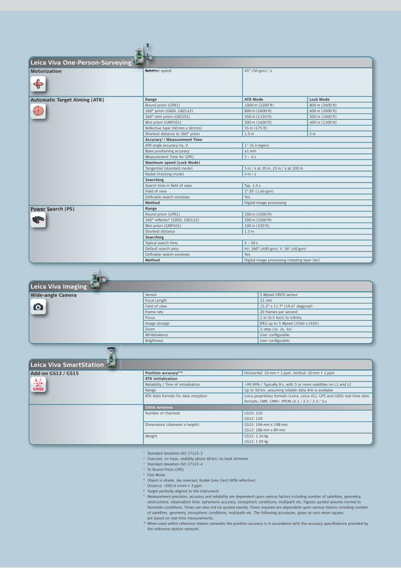
Leica Viva SmartStation
Leica Viva Imaging
Add-on GS12 / GS15 Position accuracy9,10 Horizontal: 10 mm + 1 ppm, Vertical: 20 mm + 1 ppm
RTK Initialization
Reliability / Time of initialization >99.99% / Typically 8 s, with 5 or more satellites on L1 and L2
Range Up to 50 km, assuming reliable data-link is available
RTK Data formats for data reception Leica proprietary formats (Leica, Leica 4G), GPS and GNSS real-time data
formats, CMR, CMR+, RTCM v2.1 / 2.2 / 2.3 / 3.x
GNSS Antenna
Number of channels GS15: 120
GS12: 120
Dimensions (diameter x height) GS15: 196 mm x 198 mm
GS12: 186 mm x 89 mm
Weight GS15: 1.34 kg
GS12: 1.05 kg
Wide-angle Camera Sensor 5 Mpixel CMOS sensor
Focal Length 21 mm
Field of view 15.5° x 11.7° (19.4° diagonal)
Frame rate 20 frames per second
Focus 2 m (6.5 feet) to infi nity
Image storage JPEG up to 5 Mpixel (2560 x 1920)
Zoom 3-step (1x, 2x, 4x)
Whitebalance User confi gurable
Brightness User confi gurable
Leica Viva One-Person-SurveyingMotorization Rotation speed 45° (50 gon) / s
Automatic Target Aiming (ATR) Range ATR Mode Lock Mode
Round prism (GPR1) 1000 m (3300 ft) 800 m (2600 ft)
360° prism (GRZ4, GRZ122) 800 m (2600 ft) 600 m (2000 ft)
360° mini prism (GRZ101) 350 m (1150 ft) 300 m (1000 ft)
Mini prism (GMP101) 500 m (1600 ft) 400 m (1300 ft)
Refl ective tape (60 mm x 60 mm) 55 m (175 ft) –
Shortest distance to 360° prism 1.5 m 5 m
Accuracy1 / Measurement Time
ATR angle accuracy Hz, V 1“ (0.3 mgon)
Base positioning accuracy ±1 mm
Measurement Time for GPR1 3 – 4 s
Maximum speed (Lock Mode)
Tangential (standard mode) 5 m / s at 20 m, 25 m / s at 100 m
Radial (tracking mode) 4 m / s
Searching
Search time in fi eld of view Typ. 1.5 s
Field of view 1° 30’ (1.66 gon)
Defi nable search windows Yes
Method Digital Image processing
Power Search (PS) Range
Round prism (GPR1) 300 m (1000 ft)
360° refl ector8 (GRZ4, GRZ122) 300 m (1000 ft)
Mini prism (GMP101) 100 m (330 ft)
Shortest distance 1.5 m
Searching
Typical search time 5 – 10 s
Default search area Hz: 360° (400 gon), V: 36° (40 gon)
Defi nable search windows Yes
Method Digital Image processing (rotating laser fan)
Automatic Target Aiming (ATR)
Power Search (PS)
Add-on GS12
Wide-angle Camera
Rotation speedRotation speedRotation speed

Whether you want to stake-out an object on a construction site or you
need accurate measurements of a tunnel or a bridge; whether you
want to determine the area of a parcel of land or need the position of
a power pole or to capture objects for as-built maps – you need
reliable and precise data.
Leica Viva combines a wide range of innovative products designed to
meet the daily challenges for all positioning tasks. The simple yet
powerful and versatile Leica Viva hardware and software innovations
are redefining state-of-the-art technology to deliver maximum perfor-
mance and productivity. Leica Viva gives you the inspiration to make
your ambitious visions come true.
When it has to be right.
Leica Geosystems AG Heerbrugg, Switzerland
www.leica-geosystems.com
Leica Zeno Product brochure
Leica Viva LGO Product brochure
Leica SmartWorx Viva Product brochure
Leica Viva GNSS Product brochure
Leica Viva Overview brochure
Total Quality Management – our commitment to total customer satisfaction.
Distance meter (Prism), ATR and PowerSearch:Laser class 1 in accordance with IEC 60825-1 resp. EN 60825-1
Laser plummet:Laser class 2 in accordance with IEC 60825-1 resp. EN 60825-1
Distance meter (Non-Prism): Laser class 3R in accordance with IEC 60825-1 resp. EN 60825-1
The Bluetooth® word mark and logos are owned by Bluetooth SIG, Inc. and any use of such marks by Leica Geosystems AG is under license. Other trademarks and trade names are those of their respective owners.
Illustrations, descriptions and technical data are not binding. All rights reserved. Printed in Switzerland – Copyright Leica Geosystems AG, Heerbrugg, Switzerland, 2010. 781664en – IX.10 – RDV


![Leica Viva SmartWorx Viva on TS...Measurement Frequency 0.0 0.2 0.4 0.6 0.8 1.0 1.2 1.4 Leica TS15 Trimble S8 Video-Robotic Trimble VX Topcon IS Sokkia SRX5] fast (grid scan on plane)](https://img.pdfslide.net/doc/110x75/6124bfef0f4ea468810d1bf2/leica-viva-smartworx-viva-on-ts-measurement-frequency-00-02-04-06-08-10.jpg)