Embed Size (px)
Citation preview
1
LESSON 1: THE EARTH’S ENERGY BALANCE
Key Concepts In this lesson we will focus on summarising what you need to know about:
Define the term “Energy Balance”
Clearly understand the concept of the heating of the atmosphere
Be able to explain the influence of latitude and seasons on the unequal heating of the atmosphere
Be able to differentiate between rotation (causing day and night) and revolution (causing seasons)
Clearly understand the concept of transfer of energy in the atmosphere
Clearly understand the concept of transfer of energy by ocean currents and winds
Use and interpret statistics, graphs, maps and use of an atlas in your explanations
X-PLANATION
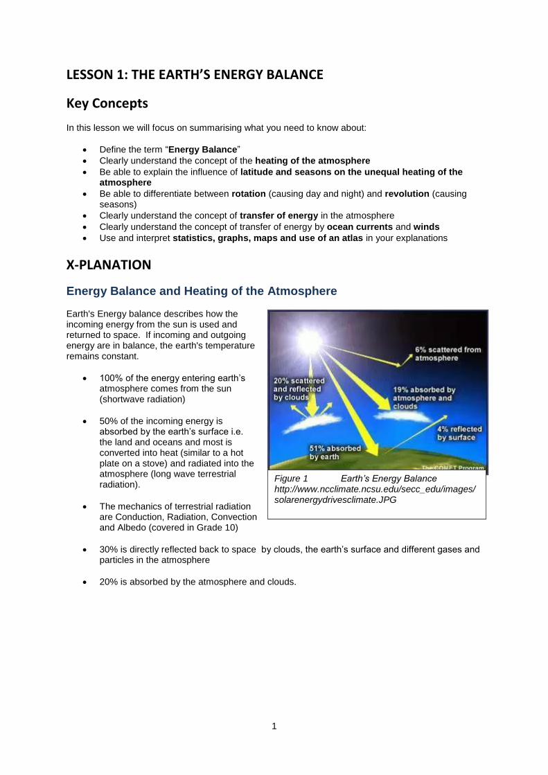
Energy Balance and Heating of the Atmosphere Earth's Energy balance describes how the incoming energy from the sun is used and returned to space. If incoming and outgoing energy are in balance, the earth's temperature remains constant.
100% of the energy entering earth’s atmosphere comes from the sun (shortwave radiation)
50% of the incoming energy is absorbed by the earth’s surface i.e. the land and oceans and most is converted into heat (similar to a hot plate on a stove) and radiated into the atmosphere (long wave terrestrial radiation).
The mechanics of terrestrial radiation are Conduction, Radiation, Convection and Albedo (covered in Grade 10)
30% is directly reflected back to space by clouds, the earth’s surface and different gases and particles in the atmosphere
20% is absorbed by the atmosphere and clouds.
Figure 1 Earth’s Energy Balance http://www.ncclimate.ncsu.edu/secc_edu/images/solarenergydrivesclimate.JPG
2
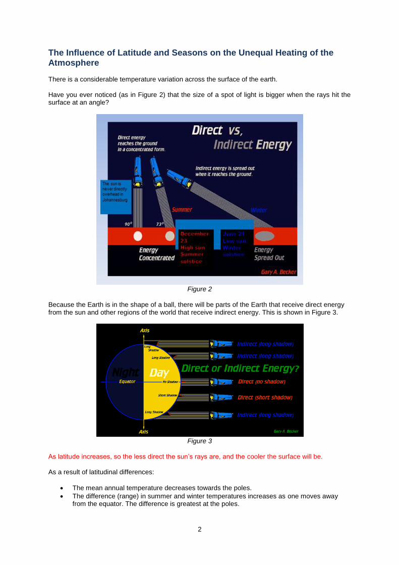
The Influence of Latitude and Seasons on the Unequal Heating of the Atmosphere There is a considerable temperature variation across the surface of the earth. Have you ever noticed (as in Figure 2) that the size of a spot of light is bigger when the rays hit the surface at an angle?
Figure 2
Because the Earth is in the shape of a ball, there will be parts of the Earth that receive direct energy from the sun and other regions of the world that receive indirect energy. This is shown in Figure 3.
Figure 3
As latitude increases, so the less direct the sun’s rays are, and the cooler the surface will be. As a result of latitudinal differences:
The mean annual temperature decreases towards the poles.
The difference (range) in summer and winter temperatures increases as one moves away from the equator. The difference is greatest at the poles.
3
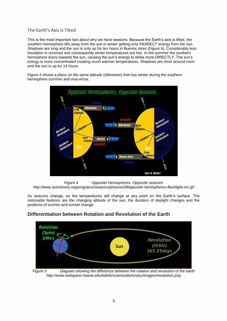
The Earth's Axis is Tilted This is the most important fact about why we have seasons. Because the Earth’s axis is tilted, the southern hemisphere tilts away from the sun in winter getting only INDIRECT energy from the sun. Shadows are long and the sun is only up for ten hours in Buenos Aires (Figure 4). Considerably less insolation is received and consequently winter temperatures are low. In the summer the southern hemisphere leans towards the sun, causing the sun’s energy to strike more DIRECTLY. The sun’s energy is more concentrated creating much warmer temperatures. Shadows are short around noon and the sun is up for 14 hours. Figure 4 shows a place on the same latitude (Allentown) that has winter during the southern hemisphere summer and visa-versa.
Figure 4 Opposite Hemispheres, Opposite seasons http://www.astronomy.org/programs/seasons/pictures/08opposite-hemispheres-flashlight-sm.gif
As seasons change, so the temperatures will change at any point on the Earth’s surface. The noticeable features are the changing altitude of the sun, the duration of daylight changes and the positions of sunrise and sunset change
Differentiation between Rotation and Revolution of the Earth
Figure 5 Diagram showing the difference between the rotation and revolution of the earth
http://www.webquest.hawaii.edu/kahihi/sciencedictionary/images/revolution.png

4
The Earth’s Rotation
Figure 6 Day and night as seen from space
http://mac.elated.com/wp-content/uploads/earth-view.jpg
Earth spins as it orbits the Sun.
It takes the Earth 24 hours to make one complete turn on its axis, so an Earth day is 24 hours long.
The Sun lights up one half of the Earth, and the other half is in shadow.
As the Earth spins we move from shadow to light and back to shadow and so on.
It is daytime in South Africa when our part of the planet is in the lit by the Sun.
And it is night-time in South Africa when our part of the planet is facing away from the Sun.
The Earth’s Revolution
The Earth revolves around our Sun.
It takes just over 365 days (one year) for the Earth to go around the Sun once.
The Earth revolves around the Sun at a rate of about 107 000 kilometres per hour.
The Earth's revolution around the sun and the tilt of its rotational axis result in the seasons.
Figure 7 Revolution of the Earth around the sun http://www.bbc.co.uk/bitesize/ks3/science/images
/position_of_earth_around_sun.gif
Transfer of Energy in the Atmosphere Sunlight is more intense at the Equator than at the poles, creating a marked difference in temperature. Ocean currents and large ‘convection cells’ in the atmosphere transport heat from the Equator towards the poles. If there was no way that the heat generated at the equator could be balanced out by the extremely cold atmosphere at the poles, the Earth as we know it would be uninhabitable. The two most important mechanisms that transfer heat energy on our planet are winds and ocean currents. Close to the Equator, most heat is carried by the oceans, but north and south of about 30 degrees latitude the atmosphere is responsible for most of the poleward heat transport.
5
The Role of Winds and Ocean Currents in Energy Transfer
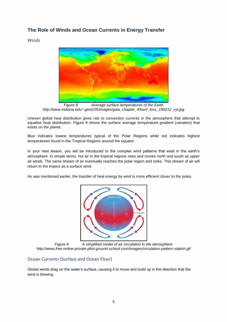
Winds
Figure 8 Average surface temperatures of the Earth
http://www.indiana.edu/~geol105/images/gaia_chapter_4/tsurf_tovs_199212_cyl.jpg Uneven global heat distribution gives rise to convection currents in the atmosphere that attempt to equalise heat distribution. Figure 8 shows the surface average temperature gradient (variation) that exists on the planet. Blue indicates lowest temperatures typical of the Polar Regions while red indicates highest
temperatures found in the Tropical Regions around the equator.
In your next lesson, you will be introduced to the complex wind patterns that exist in the earth’s
atmosphere. In simple terms, hot air in the tropical regions rises and moves north and south as upper
air winds. The same stream of air eventually reaches the polar region and sinks. This stream of air will
return to the tropics as a surface wind.
As was mentioned earlier, the transfer of heat energy by wind is more efficient closer to the poles.
Figure 9 A simplified model of air circulation in the atmosphere
http://www.free-online-private-pilot-ground-school.com/images/circulation-pattern-station.gif
Ocean Currents (Surface and Ocean Floor)
Global winds drag on the water’s surface, causing it to move and build up in the direction that the
wind is blowing.
6
Ocean currents help to distribute heat around the Earth and circulate massive amounts of warm and cold water. Research on ocean currents have revealed that there is a large scale oceanic circulation system composed of circulating water, much like one would see in the mantle and in the atmosphere.
In the case of ocean currents, surface currents move heated water away from the equator. As this
water reaches the Polar Regions, it cools and sinks to the sea floor (down welling). The current then
returns to the Equator along the sea floor. In the equatorial regions the current rises (upwelling). This
is known as a conveyer belt or thermohaline circulation. “Thermo” relates to temperature and “haline”
to the salt content. Both of these affect the density of the sea water.
Very dense water sinks, while water of a low density rises. The cycle can take up to a 1 000 years to
complete.
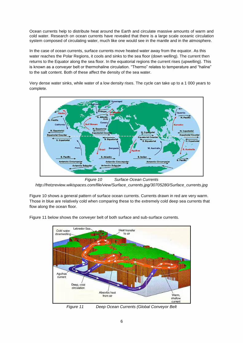
Figure 10 Surface Ocean Currents
http://fretzreview.wikispaces.com/file/view/Surface_currents.jpg/30705280/Surface_currents.jpg
Figure 10 shows a general pattern of surface ocean currents. Currents drawn in red are very warm.
Those in blue are relatively cold when comparing these to the extremely cold deep sea currents that
flow along the ocean floor.
Figure 11 below shows the conveyer belt of both surface and sub-surface currents.
Figure 11 Deep Ocean Currents (Global Conveyor Belt
7
http://www.indiana.edu/~geol105/images/gaia_chapter_4/heatpump.jpg
X-AMPLE QUESTIONS
Question 1
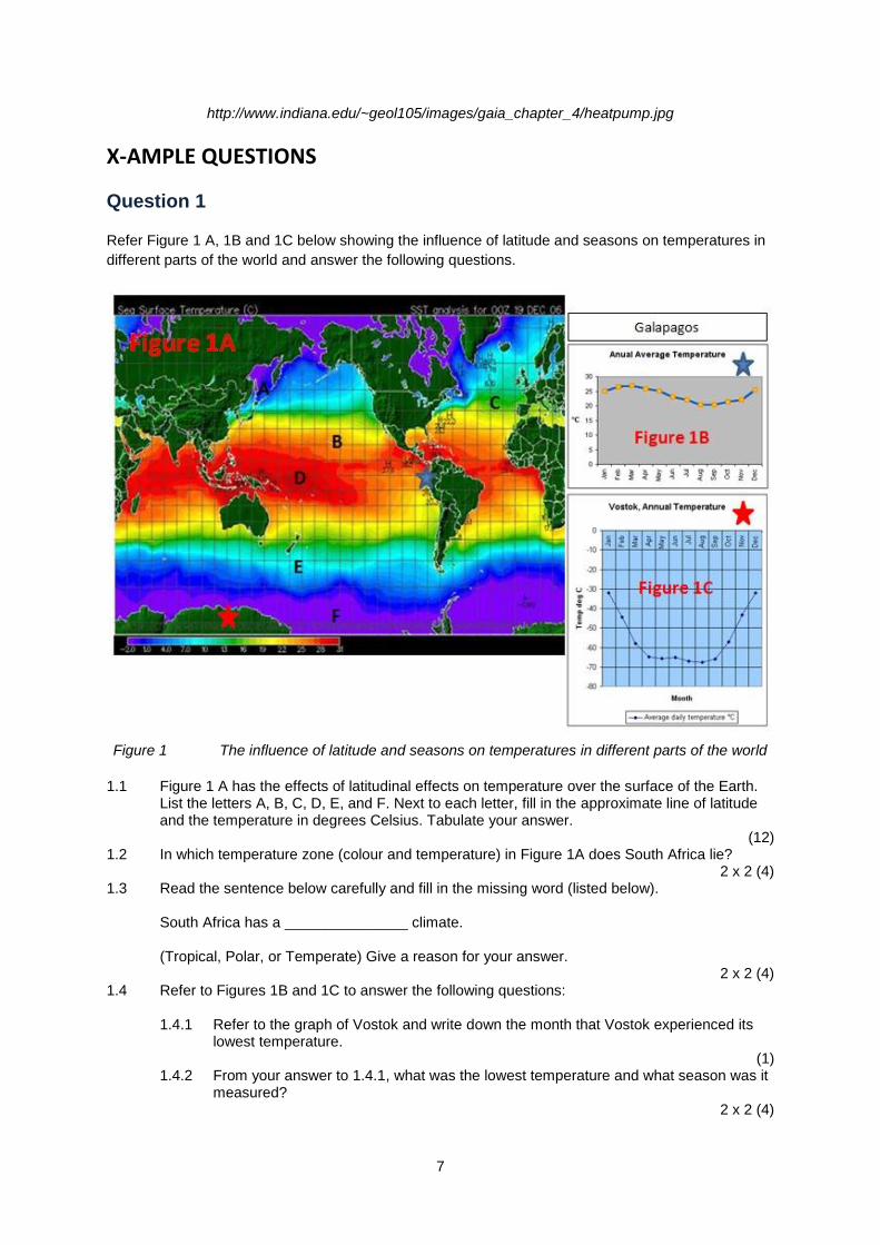
Refer Figure 1 A, 1B and 1C below showing the influence of latitude and seasons on temperatures in
different parts of the world and answer the following questions.
Figure 1 The influence of latitude and seasons on temperatures in different parts of the world
1.1 Figure 1 A has the effects of latitudinal effects on temperature over the surface of the Earth.
List the letters A, B, C, D, E, and F. Next to each letter, fill in the approximate line of latitude and the temperature in degrees Celsius. Tabulate your answer.
(12) 1.2 In which temperature zone (colour and temperature) in Figure 1A does South Africa lie?
2 x 2 (4) 1.3 Read the sentence below carefully and fill in the missing word (listed below). South Africa has a _______________ climate. (Tropical, Polar, or Temperate) Give a reason for your answer.
2 x 2 (4) 1.4 Refer to Figures 1B and 1C to answer the following questions:
1.4.1 Refer to the graph of Vostok and write down the month that Vostok experienced its lowest temperature.
(1) 1.4.2 From your answer to 1.4.1, what was the lowest temperature and what season was it
measured? 2 x 2 (4)
8
1.4.3 Refer to the graph of Galapagos and write down the month that Galapagos experienced its lowest temperature.
(1) 1.4.4 From your answer to 1.4.3, what was the highest temperature measured?
1 x 2 (2) 1.4.5 Write down the difference between the lowest temperature of Vostok in mid-winter
and the highest temperature of Galapagos in mid-summer. 1 x 2 (2)
[30]
Question 2
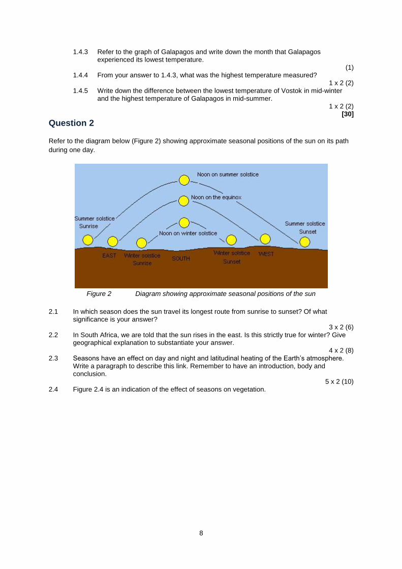
Refer to the diagram below (Figure 2) showing approximate seasonal positions of the sun on its path
during one day.
Figure 2 Diagram showing approximate seasonal positions of the sun
2.1 In which season does the sun travel its longest route from sunrise to sunset? Of what significance is your answer?
3 x 2 (6) 2.2 In South Africa, we are told that the sun rises in the east. Is this strictly true for winter? Give
geographical explanation to substantiate your answer. 4 x 2 (8)
2.3 Seasons have an effect on day and night and latitudinal heating of the Earth’s atmosphere. Write a paragraph to describe this link. Remember to have an introduction, body and conclusion.
5 x 2 (10) 2.4 Figure 2.4 is an indication of the effect of seasons on vegetation.
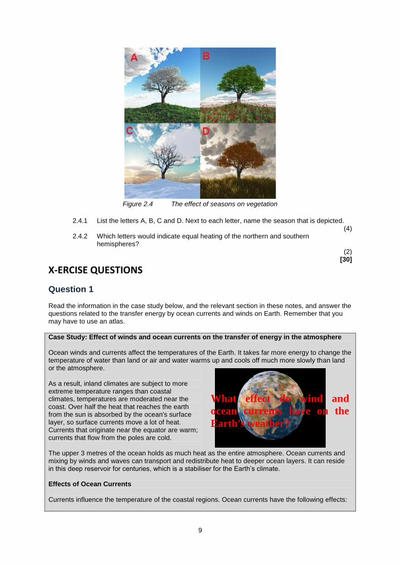
9
Figure 2.4 The effect of seasons on vegetation
2.4.1 List the letters A, B, C and D. Next to each letter, name the season that is depicted. (4)
2.4.2 Which letters would indicate equal heating of the northern and southern hemispheres?
(2) [30]
X-ERCISE QUESTIONS
Question 1 Read the information in the case study below, and the relevant section in these notes, and answer the questions related to the transfer energy by ocean currents and winds on Earth. Remember that you may have to use an atlas.
Case Study: Effect of winds and ocean currents on the transfer of energy in the atmosphere Ocean winds and currents affect the temperatures of the Earth. It takes far more energy to change the temperature of water than land or air and water warms up and cools off much more slowly than land or the atmosphere. As a result, inland climates are subject to more extreme temperature ranges than coastal climates, temperatures are moderated near the coast. Over half the heat that reaches the earth from the sun is absorbed by the ocean's surface layer, so surface currents move a lot of heat. Currents that originate near the equator are warm; currents that flow from the poles are cold. The upper 3 metres of the ocean holds as much heat as the entire atmosphere. Ocean currents and mixing by winds and waves can transport and redistribute heat to deeper ocean layers. It can reside in this deep reservoir for centuries, which is a stabiliser for the Earth’s climate. Effects of Ocean Currents Currents influence the temperature of the coastal regions. Ocean currents have the following effects:
What effect do wind and
ocean currents have on the
Earth's weather?

10
Winds blowing over a warm current become warm and at the same time and therefore allow for more evaporation. Humid winds that blow onshore from the ocean have the effect of cooling. This is due to the presence of more cloud which blocks radiation from the sun. This would be the case for Durban and the other coastal cities along our coast. Average temperatures would be greater without the day of cloud cover over the region.
Winds blowing over a cold and dry current (as in the Cold Benguela current) cool the. They help to bring down the temperatures in places, which would have been much hotter. This would be the case for temperatures measured along The South African coastline. There is little or no cloud or rainfall. These areas will be on average cooler for their latitudinal position.
When we compare maps of wind and ocean currents at a global scale we see that they share most of the same features. Note in particular the circulation patterns that form in both wind and water in each of the world’s ocean basins. The similarity arises from the fact that wind is the fundamental driver of surface ocean currents.
Figure 1 A Ocean currents of the world
Figure 1 B Average Global wind streams of the world
Conveyer Belt

11
The whole ocean current system is all linked together in a loop which is called the ocean conveyor belt. The red lines represent the warm surface currents. The Gulf Stream is the best known of them. The blue represent the cold currents running in the opposite direction on the sea floor.
Figure 1 C The ocean conveyer
On a global scale the ocean conveyer belt originates in the North Atlantic, where cold, salty water sinks and forms North Atlantic Deep Water.
This water flows southward all the way to the Southern Ocean, where it turns eastward.
As this deep ocean current travels east, some of it branches northward into the Indian Ocean, while the rest continues on into the Pacific Basin before turning north.
Along the way, this deep ocean water mixes with other deep water, gradually becoming slightly warmer and less salty.
In the North Pacific and the northern Indian Ocean, upwelling draws the water back to the surface.
Surface currents then drive the water back to the west at low latitudes.
As the water warms, evaporation increases its salinity.
After rounding the southern tip of Africa, the water crosses the Atlantic and heads north as the Gulf Stream.
The Gulf Stream returns to the North Atlantic, where the warm, salty water cools, sinks, and starts the cycle over.
This cycle take about 1000 years to complete one loop.
1.1 Differentiate between a Continental effect and a Maritime effect on the uneven heating of the
Earth’s surface 4 x 2 (8)
1.2 Which of the following will heat up and cool the fastest? (Solid/liquid/gas) 1 x 2 (2)
1.3 Winds and ocean currents transfer heat from the equator to the poles. At which latitudes is wind the most efficient, compared to ocean currents, in moving heat away from the Equator?
2 x 2 (4) 1.4 In which latitudes would the role of wind and ocean currents be similar. Give a reason for your
answer. 2 x 2 (4)
1.5 Where is most (over half) of the sun’s energy stored? Of what significance is this? 5 x 2 (10)
12
1.6 Briefly explain the effects that the two ocean currents flowing on the east coast and west coast of South America (Southern hemisphere) have on the uneven heating of the two coastlines respectively. In addition, name the two currents.
6 x 2(12) 1.7 Refer to Figures 1 A and 1 B and answer the following questions: 1.7.1 In which direction are the gyres (circular currents) rotating at P and R?
1 x 2 (2) 1.7.2 From your answer to Question 1.6, in which direction are southern hemisphere gyres
circulating? 1 x 2 (2)
1.7.3 Refer to both Figure 1 A and 1 B. List the letters showing the major gyres and match them up with the wind circulation patterns in numerals.
(4) 1.7.4 In which hemisphere are the wind circulation patterns more a duplicate of the ocean gyres?
Why would this be the case? 2 x 2(4)
1.8 Prove or disprove the following statement:
“All east coasts of continents are warmer as they have warm current flowing past them.”
1.9 Explain how the word thermohaline is derived. 3 x 2 (6)
1.10 Explain the role that the “thermohaline” current plays in regulating temperatures on the Earth. 2 x 2 (4)
[62]
SOLUTIONS TO X-ERCISE QUESTIONS
Question 1 1.1 Continental effect: Interior of continents where heating and cooling of the
solid surface is a daily and seasonal phenomenon (2) Very high temperature ranges are measured (2)
Maritime effect: Places along the coastline have the moderating effect of
the ocean where temperatures of the ocean do not vary much (2) Small temperature ranges are measured.
4 x 2 (8) 1.2 Gas (1)
1 x 2 (2) 1.3 Wind: Polar latitudes (2) Currents: Tropical latitudes (2)
2 x 2 (4) 1.4 Mid-latitudes (2) This could be considered as a transition zone (2)
2 x 2 (4) 1.5 More than half the insolation received by the sun is stored in the top 3m (2) of the oceans (2).
Air in contact with the ocean surface will take on that temperature (2). Warm winds will distribute heat from the warm ocean atmosphere (2) to the colder Polar Regions. Cold air above cold oceans is transported to the warmer areas (2) In this way, the unequal heating of the atmosphere is lessened. (2)
5 x 2 (10)
13
1.6
South America East coast
South America West coast
Warm Brazil Current (2) Warmer diurnal (2) and seasonal (2)temperatures at the same latitude (2)
Cold Humboldt (2) Colder diurnal (2) and seasonal (2) temperatures at the same latitude (2)
6 x 2(12) 1.7.1 Clockwise (2)
1 x 2 (2) 1.7.2 Anticlockwise
1 x 2 (2) 1.7.3 P 4 (1)
Q 1 (1) R 3 (1) S 2 (1)
(4) 1.7.4 Northern hemisphere (2) More land masses to contain the currents (2)
2 x 2(4) 1.8 The statement is partially true (2). The exceptions to the currents along east coasts being
warmer are the west coast of North America (Alaskan current) (2), and the current flowing north along the coast of Western Europe (North Atlantic Drift) (2)
3 x 2 (6) 1.9 Thermo temperature (2) of sea water that affects density (2) Haline Concentration of salt in the water also affecting density (2)
2 x 2 (4) 1.10 Thermohaline is also known as the Earth temperature conveyer belt (2) There are deep sea currents which flow in the opposite direction to surface currents (2) Both
surface and deep sea currents are connected (2) Since the first 3 metres of the ocean surface holds more than half the energy derived from the sun (2), the conveyer belt is the most powerful tool that the earth has to balance out the unequal heating of the earth surface (2).
4 x 2 (8) [70]