Embed Size (px)
Citation preview
24 | Air & Space Power Journal
Air Force Institute of Technology
Precision Position, Navigation, and Timing
without the Global Positioning System
Maj Kenneth A. Fisher, PhD, USAF Dr. John F. Raquet*
*Major Fisher, an assistant professor of electrical engineering at the Air Force Institute of Technology (AFIT), Wright-Patterson AFB, Ohio, serves as deputy director of the Advanced Navigation Technology (ANT) Center, an AFIT Center of Excellence. Dr. Raquet, an associate professor of electrical engineering at AFIT, serves as director of the ANT Center.
The NAVSTAR Global Positioning Sys-tem (GPS) has revolutionized mod-ern warfare. Since 2005 almost all US
precision-guided munitions have used GPS targeting data.1 Consequently, weapons de-livery systems are able to strike enemy tar-gets with precision, often resulting in little or no collateral damage. Furthermore, nearly all military assets, including aircraft, tanks, ships, missiles, mortar rounds, cargo boxes, and dismounted Soldiers rely on the accu-rate position determination that GPS provides.
For military users of this system, two main limitations emerge. First, the system relies on line of sight—that is, the satellites must be in “view” of the receiver’s antenna so that it can acquire the signals. This limi-tation is most pronounced indoors (includ-ing underground) and in urban areas, pre-senting significant navigational challenges for ground forces, remotely piloted aircraft, and precision munitions. Tall buildings in urban areas block satellites from view and create reflected or “multipath” signals, con-fusing GPS receivers. Indoors, GPS signals are present but greatly attenuated; as a re-sult, ground forces operating under protec-tive cover have difficulty obtaining a reli-able GPS position.
Second, adversaries can easily defeat the system’s signals by using simple techniques
and readily available equipment. “Jamming” results when adversaries emit signals that interfere with the relatively low-powered GPS signals. Reportedly, China has de-ployed GPS jammers in a fleet of vans, and several Internet sites even offer small, in-expensive devices to counter GPS-based vehicle tracking.2
Finally, a severer yet far less likely de-nial scenario involves other nations using antisatellite technology to disable or destroy one or more satellites in the GPS constella-tion. Three nations already possess such technology: the United States, Russia, and China, which demonstrated an antisatellite capability with a surprising attack on one of its own aging weather satellites in 2007.3
Regardless of the reason, when GPS capa-bilities become degraded or unavailable, the military needs a navigation alternative that offers comparable accuracy and utility. Re-searchers in the Advanced Navigation Tech-nology (ANT) Center at the Air Force Insti-tute of Technology (AFIT) are working to provide GPS-like accuracy without the use of GPS. The ANT Center is investigating methods to calculate position by using radio beacons, man-made and naturally occurring signals of opportunity (SoOP) (including magnetic fields), and vision aiding. In the future, a robust alternative to GPS will
http://www.airpower.au.af.milLet Us Know What You Think! Leave Comment!
Top
Report Documentation Page Form ApprovedOMB No. 0704-0188
Public reporting burden for the collection of information is estimated to average 1 hour per response, including the time for reviewing instructions, searching existing data sources, gathering andmaintaining the data needed, and completing and reviewing the collection of information. Send comments regarding this burden estimate or any other aspect of this collection of information,including suggestions for reducing this burden, to Washington Headquarters Services, Directorate for Information Operations and Reports, 1215 Jefferson Davis Highway, Suite 1204, ArlingtonVA 22202-4302. Respondents should be aware that notwithstanding any other provision of law, no person shall be subject to a penalty for failing to comply with a collection of information if itdoes not display a currently valid OMB control number.
1. REPORT DATE 2011 2. REPORT TYPE
3. DATES COVERED 00-00-2011 to 00-00-2011
4. TITLE AND SUBTITLE Precision Position, Navigation, and Timing without the GlobalPositioning System
5a. CONTRACT NUMBER
5b. GRANT NUMBER
5c. PROGRAM ELEMENT NUMBER
6. AUTHOR(S) 5d. PROJECT NUMBER
5e. TASK NUMBER
5f. WORK UNIT NUMBER
7. PERFORMING ORGANIZATION NAME(S) AND ADDRESS(ES) Air Force Research Institute (AFRI),Air & Space Power Journal,155 N.Twining Street,Maxwell AFB,AL,36112
8. PERFORMING ORGANIZATIONREPORT NUMBER
9. SPONSORING/MONITORING AGENCY NAME(S) AND ADDRESS(ES) 10. SPONSOR/MONITOR’S ACRONYM(S)
11. SPONSOR/MONITOR’S REPORT NUMBER(S)
12. DISTRIBUTION/AVAILABILITY STATEMENT Approved for public release; distribution unlimited
13. SUPPLEMENTARY NOTES
14. ABSTRACT
15. SUBJECT TERMS
16. SECURITY CLASSIFICATION OF: 17. LIMITATION OF ABSTRACT Same as
Report (SAR)
18. NUMBEROF PAGES
10
19a. NAME OFRESPONSIBLE PERSON
a. REPORT unclassified
b. ABSTRACT unclassified
c. THIS PAGE unclassified
Standard Form 298 (Rev. 8-98) Prescribed by ANSI Std Z39-18
Air Force Institute of Technology
Summer 2011 | 25
Air Force Institute of Technology
likely employ a combination of these tech-niques. A review of basic navigation con-cepts will help place these non-GPS ap-proaches in perspective.
Navigation: An Overview
What Is Navigation?
In early history, mankind was predomi-nantly interested in localized navigation, which entails determining a position in the vicinity of a local living area. People did so mostly by identifying landmarks and using their known locations to determine posi-tion. Later, especially when ship travel greatly expanded mobility, travelers needed a means of global navigation.4 Early sailors navigated by keeping track of the direction and distance traveled on each leg of a voy-age, a technique known as dead reckoning.5 Even though navigation has improved dra-matically, many modern systems (such as an inertial navigation system [INS]) are still based on dead reckoning (from the perspec-tive of starting from an assumed position and tracking changes in position, speed, di-rection, and/or distance over time).
Navigation Trends
Though modern INS can be quite accurate over short periods of time, precise naviga-tion and coordination over vast regions re-quire extremely rigorous positional infor-mation—thus the need for GPS technology. GPS has become the cornerstone of modern navigation, and improvements in its tech-nology over the past 20–30 years offer sys-tem users the ability not only to navigate precisely to within feet or even inches of the intended destination, but also to syn-chronize operational systems and equip-ment for unprecedented efficiency. For military users, these efficiencies translate into operational advantage through economy of force, mass, and the element of surprise. The Department of Defense and commer-cial industry increasingly use systems in which multiple, interdependent vehicles
work together to attain a goal or mission (often automatically)—an objective that al-most always requires reliable navigation. In fact, a number of systems need GPS in or-der to operate (not just navigate), taking for granted the system’s availability. Further-more, improvements in GPS accuracy (in both equipment and the algorithms that support it, such as differential GPS) can re-move most of the errors found in its sig-nals. Now, users can routinely obtain near-centimeter-level positioning accuracy for certain applications such as precision land-ing and, in the future, automated aerial re-fueling of military aircraft. As the pool of potential “customers” of GPS technology grows, the market is responding with lower-cost, smaller receivers to satisfy demand. The ubiquity of GPS has increased the incli-nation of users (especially those in the mili-tary) to track everything—every Airman or Soldier engaged in combat operations, every piece of airfield equipment, every vehicle, and so forth. In the past, we were content to track only major items of equipment such as aircraft because of the size and ex-pense of traditional navigation devices and early GPS receivers. Today, literally every Soldier can have a GPS receiver in his or her rucksack.
As military and commercial reliance on GPS increases, so does vulnerability to in-terruption or defeat of the system. There-fore, users need equipment with backup navigational and synchronizing capability for situations in which GPS does not work. The chief scientist of the Air Force recently identified “PNT [position, navigation, and timing] in GPS-denied environments” as one of the top 12 (in terms of priority) re-search areas that we should emphasize in the near future.6 Researchers at the ANT Center focus on exactly this problem by considering navigation approaches that do not rely upon GPS.
Since the system does offer accurate PNT in most situations, a suitable alternative usu-ally demands combining two or more sen-sors using a navigation algorithm. The re-mainder of this article explains the general
26 | Air & Space Power Journal
concepts underlying navigation algorithms and sensor integration and then describes four different non-GPS navigation tech-niques under research at the ANT Center.
Navigation Algorithms and Sensor Integration
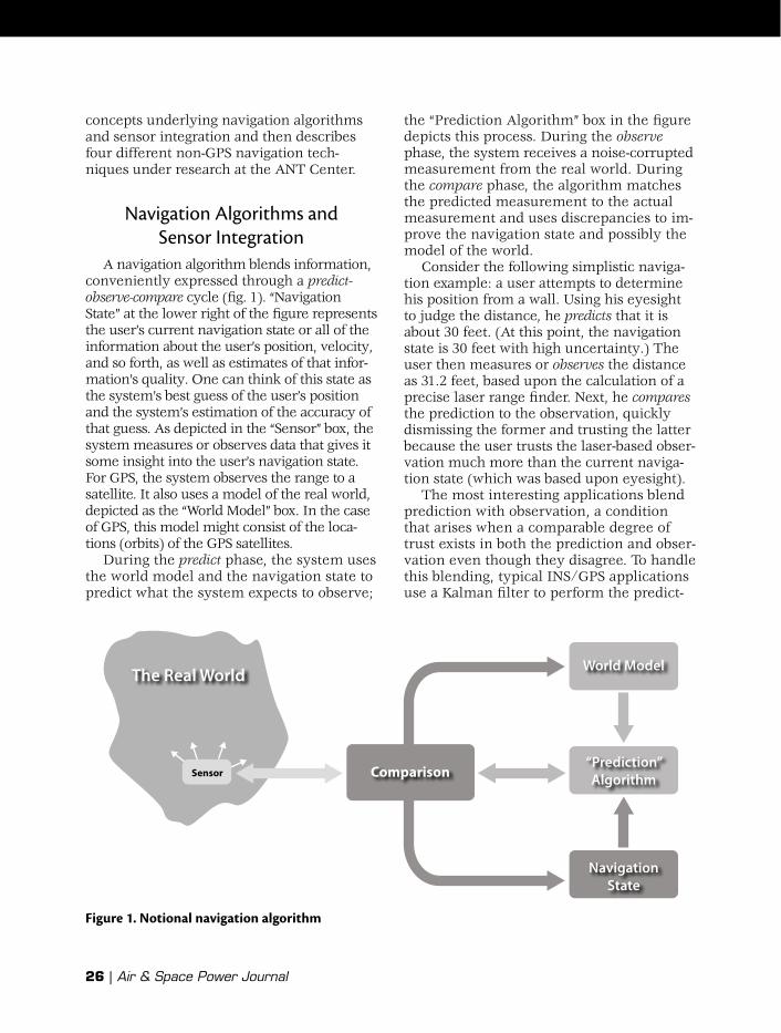
A navigation algorithm blends information, conveniently expressed through a predict-observe-compare cycle (fig. 1). “Navigation State” at the lower right of the figure represents the user’s current navigation state or all of the information about the user’s position, velocity, and so forth, as well as estimates of that infor-mation’s quality. One can think of this state as the system’s best guess of the user’s position and the system’s estimation of the accuracy of that guess. As depicted in the “Sensor” box, the system measures or observes data that gives it some insight into the user’s navigation state. For GPS, the system observes the range to a satellite. It also uses a model of the real world, depicted as the “World Model” box. In the case of GPS, this model might consist of the loca-tions (orbits) of the GPS satellites.
During the predict phase, the system uses the world model and the navigation state to predict what the system expects to observe;
the “Prediction Algorithm” box in the figure depicts this process. During the observe phase, the system receives a noise-corrupted measurement from the real world. During the compare phase, the algorithm matches the predicted measurement to the actual measurement and uses discrepancies to im-prove the navigation state and possibly the model of the world.
Consider the following simplistic naviga-tion example: a user attempts to determine his position from a wall. Using his eyesight to judge the distance, he predicts that it is about 30 feet. (At this point, the navigation state is 30 feet with high uncertainty.) The user then measures or observes the distance as 31.2 feet, based upon the calculation of a precise laser range finder. Next, he compares the prediction to the observation, quickly dismissing the former and trusting the latter because the user trusts the laser-based obser-vation much more than the current naviga-tion state (which was based upon eyesight).
The most interesting applications blend prediction with observation, a condition that arises when a comparable degree of trust exists in both the prediction and obser-vation even though they disagree. To handle this blending, typical INS/GPS applications use a Kalman filter to perform the predict-
The Real World
Sensor Comparison
World Model
“Prediction”Algorithm
NavigationState
Figure 1. Notional navigation algorithm
Summer 2011 | 27
Air Force Institute of Technology
observe-compare cycle.7 The INS predicts the user’s position by keeping track of his or her movements, and then the GPS re-ceiver “observes” the user’s position by us-ing measurements from the system’s satel-lites. Finally, a Kalman filter compares the INS prediction to the GPS observation, gen-erating a blended solution based upon the relative quality of the two results.
Typical modern navigation systems blend an INS with GPS updates to produce a robust navigation estimate—“robust” because the dual inputs complement each other. The INS provides a nearly continuous, accurate esti-mate of vehicle motion but accumulates er-rors over time. For example, even the most precise INS initialized very close to the true position will eventually amass errors that render its position estimate unusable. Con-versely, GPS updates occur less frequently, but errors do not accumulate. Used in tan-dem, the INS supplies an accurate naviga-tion estimate over the short term while GPS provides an accurate solution over the lon-ger term. In other words, the GPS sensor constrains the drift of INS errors.
Four Promising Navigation Techniques for Position,
Navigation, and Timing in GPS-Denied Environments
Navigation Using Beacons
Beacons (i.e., sources of man-made signals broadcast for navigational purposes that augment or replace GPS signals) can counter act the effects of intentional inter-ference or weak signal environments. The Defense Advanced Research Projects Agency (DARPA) instituted a program to “demonstrate the use of airborne pseudo-lites, which are high-power, GPS-like trans-mitters on aircraft, to broadcast a powerful replacement GPS signal that ‘burns through’ jammers and restores GPS navigation over a theater of operations.”8 Actual field demon-strations showed that airborne pseudolites
could replace satellite broadcasts, providing good-quality navigation signals to military GPS receivers with only software modifica-tions to the receivers.
Other researchers use beacons to trans-mit unique signals that require receivers specifically designed to navigate, based upon those signals. One company uses ter-restrial beacons placed in a local area to as-sist GPS or to navigate without that system.9 One can even use these beacons to locate someone’s position within a subterranean mining complex; moreover, they might prove useful to ground troops operating in enclosed locations. From an operational viewpoint, this approach necessitates field-ing transmitters from either ground sites or airborne platforms.
Navigation Using Man-Made Signals of Opportunity
GPS navigates by tracking signals transmit-ted from satellites. Navigation that uses SoOPs builds upon this concept, except that SoOP navigation tracks signals transmitted for purposes other than navigation (e.g., AM and FM radio, satellite radio, television, cellular phone transmissions, wireless com-puter networks, and numerous satellite sig-nals). ANT Center researchers have ex-plored television signals, AM radio signals, digital audio/video broadcasts, and wireless networks.10 Given the wide variety of SoOPs available, researchers developed a mathe-matical tool to determine such a signal’s usefulness for navigation.11
SoOP navigation enjoys several advan-tages over GPS. First, SoOPs are abundant, ensuring the availability of sufficient signals for position determination and for reducing position error. Second, SoOPs are often re-ceived at higher signal strength than GPS signals.12 (Unlike GPS signals, those from FM radio stations or cellular phones are of-ten available and usable indoors.) Finally, the navigational user incurs no deployment costs or operating expenses related to the SoOPs. (Of course, mobile receivers, akin to
28 | Air & Space Power Journal
GPS receivers, would require design and fabrication to field such a system.)
Using SoOPs for navigation purposes does have disadvantages, however. Because the system did not intend that these signals be used for navigation, their timing is nei-ther necessarily linked nor synchronized. Additionally, the navigation user may not know exactly what was transmitted. To al-leviate these two issues, typical SoOP navi-gation scenarios employ a base station—a receiver at a known location within the vi-cinity of the user’s receiver. The base sta-tion enables the latter device to extract fea-tures from the SoOP, making the timing issues less severe. Most algorithms also as-sume that the SoOP transmitter (e.g., the radio station tower or wireless router) occu-pies a known location although methods exist for determining this information. Multi path or reflected signals—predomi-nant error sources in SoOP navigation—of-ten prove difficult to eliminate.
Orthogonal frequency-division multiplex-ing represents a particularly promising SoOP signal structure used for digital au-dio/video broadcasts and many wireless network devices. These signals exhibit navi-gation benefits not found in others, such as redundant information interwoven within the signals, from which a user may obtain navigation data by eavesdropping (i.e., pas-sively listening to a signal) without using a base station.13 Closely related research in-cludes attempts to use radio-frequency finger printing to associate each signal with a particular transmitter.14
There are also SoOP navigation methods other than the ones that use timing infor-mation obtained from tracking a SoOP (akin to GPS navigation). For example, we can make use of angle-of-arrival data (typically found using multiple antennas) for naviga-tion by bisecting multiple arrival angles to determine the receiver’s position by trian-gulation. Additionally, we can utilize a SoOP’s received signal strength (RSS) to estimate the range to a particular transmitter. A com-mercial vendor even offers a database of
wireless network locations and transmitted power for use in RSS calculations.15
Navigation Using Naturally Occurring Signals of Opportunity
Although man-made SoOPs represent a rich field of study, naturally occurring SoOPs are also available. Fundamentally, any source that allows someone to distinguish one position on Earth from another is suit-able for navigation. A phenomenon’s use-fulness for positioning often depends upon how reliably we can measure it; how well the measurement corresponds to a user’s position; and the size, weight, and power of the sensor. Numerous naturally occurring SoOPs are potentially suitable for naviga-tion, including magnetic fields, gravitational fields, and lightning strikes; however, navi-gation based on magnetic fields remains the most promising for military applications.
We find magnetic fields (in varying in-tensities) everywhere on Earth. In addition to Earth’s main magnetic field, other such fields occur in any conductive material (such as rebar, wall studs made of steel, pipes, wiring, etc.). Thus, the magnetic field intensity at a specific point in a particular hallway in a particular building is unique. Researchers at the ANT Center have tested the feasibility of using such intensities to aid navigation systems indoors by first com-paring measurements from a small magne-tometer (about the size of a deck of cards) to a previously determined magnetic field map of the indoor area.16 Then, they deter-mined the user’s position by finding the location on the map having the highest cor-relation with the magnetometer measure-ment. Although the results proved quite promising, a couple of areas require more research. First, the system relied upon a previously determined magnetic field map. Because we cannot realistically expect war fighters to survey an area, research is un-der way to build a magnetic field map as they move. Second, researchers are explor-ing variations in magnetic fields over time and the resistance of the magnetic field
Summer 2011 | 29
Air Force Institute of Technology
navigation algorithm to large deviations in the observed field (which may occur with the addition or removal of metal objects from the scene).
Vision-Aided Navigation
Vision-aided navigation uses cameras to produce an alternative and highly comple-mentary system for constraining inertial drift. Instead of directly computing the loca-tion of the vehicle, vision systems use the perceived motion from image sensors to aid the INS. For example, suppose a person rotates as he or she sits in a chair. Physiologically, the vestibular system senses the rotation; however, eyesight can aid in the rotation estimate by observing the motion of visual cues. In a similar fashion, vision sensors can aid an INS and thereby improve navigation.
Other than improved navigation perfor-mance, several advantages accompany vision-aided navigation systems. First, computer vision techniques are immune to attacks that disable GPS (although vision-based tools do have their own limitations, such as those imposed by fog or smoke). Second, as cameras and computers become more ca-pable and less expensive, computer vision is quickly becoming a realizable and cost-effective solution. Third, a camera used for navigation can also gather intelligence. Similarly, a camera used for intelligence gathering may also lend itself to navigation. Furthermore, we can integrate data with mapping information from the National Geospatial-Intelligence Agency or commer-cial imagery providers such as Google Maps.
Due to computing complexity, typical vision-aiding algorithms employ features selected from an image rather than the en-tire image. The algorithm matches features between successive images to estimate the relative motion of the platform. The quality of feature matching depends upon the char-acterization and identification of the fea-tures in subsequent images. We can further reduce computational complexity by limit-ing the analysis to a small portion of an im-age. These computational improvements
allow us to utilize vision systems on rela-tively small platforms. ANT Center re-searchers have combined a faster but less robust feature-tracking algorithm with a commercial-grade INS to attain real-time performance on a small indoor remotely piloted aircraft.17
The distance from the camera to a feature (i.e., depth perception) represents a key as-pect of image-aided navigation. ANT Center researchers have mimicked human eyesight by using two cameras for stereo, image-aided navigation and have demonstrated their al-gorithms in near real time.18 Unfortunately, this method relies on physical separation between the cameras, so we cannot readily employ it in miniaturized applications (e.g., on board a micro aerial vehicle).
Augmenting a single camera with a small, gimbaled laser range sensor avoids the physical requirements of stereo vision systems. The ANT Center has used such a sensor to measure the depth to any near object within a camera’s field of view.19 These sensors, along with an inertial sen-sor, can help navigate a micro aerial ve-hicle without the use of GPS—an ideal setup for indoor exploration and mapping missions. In addition to providing a non-GPS navigation solution, this small, light-weight sensor combination can locate and image objects or targets for use in intelli-gence or targeting applications.
Unlike selecting features, predictive ren-dering—another area of active research in vision-aided navigation—uses knowledge about an object to estimate a platform’s mo-tion. Researchers at the ANT Center are ap-plying this method to air-refueling scenar-ios. Specifically, a three-dimensional model of the tanker aircraft permits computers to predict an image of the aircraft from the perspective of the receiver platform. After cameras capture an actual image, an algo-rithm compares the predicted to the ob-served image. This navigation scheme uses image-processing techniques that simplify the correlation between predicted and true images (i.e., the extent to which the two im-ages match).20
30 | Air & Space Power Journal
Combining a Communications/Navigation Device with a Vision-Aided Inertial Navigation SystemOne promising concept may give the war
fighter an integrated handheld device for communications and navigation. Dis-mounted Soldiers frequently carry both a handheld radio and a GPS receiver. Combin-ing these devices into one unit would allow those Soldiers to use the communications link between the radios to make positioning less reliant upon GPS. Furthermore, an on-board vision-aided INS offers short-term sta-bility and attitude information. Just as a GPS-aided INS combines the long-term sta-bility of GPS solutions with the short-term stability of an INS, so may the proposed in-tegrated device have potential for relatively long-term, precise non-GPS navigation.
Researchers at the ANT Center and Ray-theon Corporation are using ranging mea-surements based upon a Raytheon DH-500 handheld communication device to deter-mine the user’s position without resorting to GPS.21 This packet radio system features ranging capability in addition to robust communication. Recently, the ANT Center combined Raytheon DH-500 radio-ranging measurements with a stereo vision-aided INS for precise non-GPS navigation.22
This type of research serves as the gate-way to a broader class of problems—namely, using combined navigation/com-munications handheld devices augmented with other sensors to navigate and commu-nicate synergistically. These devices may also permit multiple platforms to cooperate within a network, offering even more infor-mation from which to navigate.
One Size Does Not Fit AllFor the vast majority of military applica-
tions, GPS (or GPS with INS) meets naviga-tion performance requirements when it is available. If the system is not available, we must fall back on alternative navigation approaches like those described above.
However, compared with GPS, all of the latter have significant drawbacks. For ex-ample, beacon-based navigation does not apply worldwide and requires deployment of beacons. Navigation using SoOPs must have access to the right kinds of signals (it is also susceptible to all of the other down-sides described previously). Vision-based navigation does not work well in fog or over the ocean. Radio-ranging-based navi-gation works only in the context of mul-tiple vehicles. Consequently, no single ap-proach would serve well as an alternative to GPS in all environments. Research that develops our ability to navigate using non-GPS signals is important and should con-tinue. However, simply having more op-tions does not offer a complete answer.
The Way Ahead: All-Source Navigation
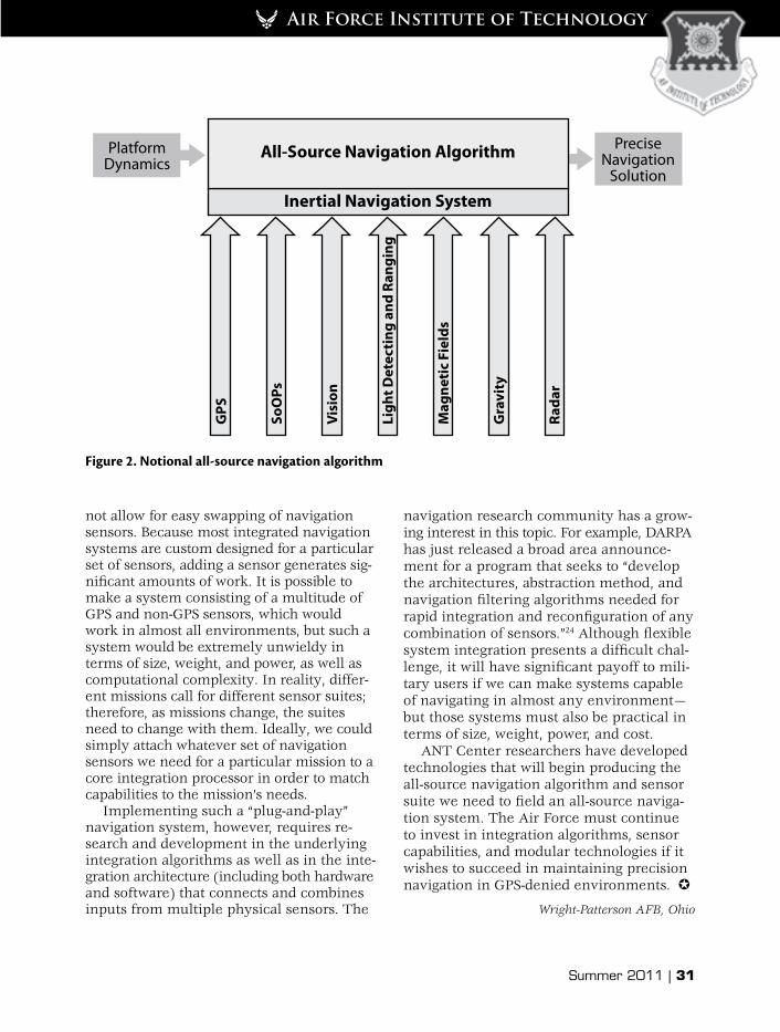
The Air Force must embrace an all-source navigation approach to solve preci-sion navigation without GPS.23 An all-source navigation algorithm computes a precise solution from the platform dynamics, using all available information. Figure 2 depicts a notional scenario that relies upon an INS and uses the following additional sensor in-formation: GPS, SoOPs, vision, light detect-ing and ranging, magnetic fields, gravity, and radar. Note the intentional inclusion of GPS (an all-source navigation system should use that system when it is available). Thus, the system combines all available informa-tion and employs a reduced sensor subset when some sensors are not accessible.
The ANT Center is developing systems that can easily adapt to specific situations by using the most appropriate sensors. For ex-ample, image-based navigation may prove suitable for an urban environment in day-time, whereas a less accurate gravity-field-based approach may be the most appropriate for en route navigation over the ocean. Clearly, different situations call for different sensor suites. Problematically, however, cur-rent integration architectures generally do
Summer 2011 | 31
Air Force Institute of Technology
not allow for easy swapping of navigation sensors. Because most integrated navigation systems are custom designed for a particular set of sensors, adding a sensor generates sig-nificant amounts of work. It is possible to make a system consisting of a multitude of GPS and non-GPS sensors, which would work in almost all environments, but such a system would be extremely unwieldy in terms of size, weight, and power, as well as computational complexity. In reality, differ-ent missions call for different sensor suites; therefore, as missions change, the suites need to change with them. Ideally, we could simply attach whatever set of navigation sensors we need for a particular mission to a core integration processor in order to match capabilities to the mission’s needs.
Implementing such a “plug-and-play” navigation system, however, requires re-search and development in the underlying integration algorithms as well as in the inte-gration architecture (including both hardware and software) that connects and combines inputs from multiple physical sensors. The
navigation research community has a grow-ing interest in this topic. For example, DARPA has just released a broad area announce-ment for a program that seeks to “develop the architectures, abstraction method, and navigation filtering algorithms needed for rapid integration and reconfiguration of any combination of sensors.”24 Although flexible system integration presents a difficult chal-lenge, it will have significant payoff to mili-tary users if we can make systems capable of navigating in almost any environment—but those systems must also be practical in terms of size, weight, power, and cost.
ANT Center researchers have developed technologies that will begin producing the all-source navigation algorithm and sensor suite we need to field an all-source naviga-tion system. The Air Force must continue to invest in integration algorithms, sensor capabilities, and modular technologies if it wishes to succeed in maintaining precision navigation in GPS-denied environments.
Wright-Patterson AFB, Ohio
PlatformDynamics
PreciseNavigation
SolutionAll-Source Navigation Algorithm
Inertial Navigation SystemG
PS
SoO
Ps
Visi
on
Ligh
t Det
ecti
ng a
nd R
angi
ng
Mag
neti
c Fi
elds
Gra
vity
Rada
r
Figure 2. Notional all-source navigation algorithm
32 | Air & Space Power Journal
1. John W. Moyle, “The Space and Air Force: One Pathway to the Future,” Air and Space Power Journal: Chronicles Online Journal, accessed 15 March 2011, http://www.airpower.maxwell.af.mil/airchronicles /cc/moyle.html.
2. Alan Cameron, “Perspectives—June 2008,” 24 June 2008, GPS World, http://www.gpsworld.com /gnss-system/perspectives-june-2008-7254.
3. Michael P. Pillsbury, PhD, An Assessment of China’s Anti-satellite and Space Warfare Programs, Policies and Doctrines, Report to the US-China Eco-nomic and Security Review Commission, 19 January 2007, http://www.uscc.gov/researchpapers/2007 /FINAL_REPORT_1-19-2007_REVISED_BY_MPP.pdf.
4. The term navigate means “to record, plan, and control the position and course of [a ship or an air-craft].” It is derived from the Latin navigare, which comes from navis or “ship” and agere, “to direct.” Webster’s II: New Riverside University Dictionary, 1988, s.v. “navigate.”
5. A common tool for direction finding—a mag-netic compass—was introduced in China in the twelfth century. People commonly determined dis-tance by noting the ship’s speed and time. See Pratap Misra and Per Enge, Global Positioning Sys-tem: Signals, Measurements, and Performance (Lin-coln, MA: Ganga-Jamuna Press, 2001).
6. United States Air Force Chief Scientist (AF/ST), Report on Technology Horizons: A Vision for Air Force Science and Technology during 2010–2030, vol. 1, AF/ST-TR-10-01-PR (Washington, DC: Headquarters US Air Force, Office of the USAF Chief Scientist, 15 May 2010), 76, http://www.aviationweek.com/media/pdf /Check6/USAF_Technology_Horizons_report.pdf.
7. The filter is named after Rudolph Kalman, who first published his predict-observe-compare algorithm in “A New Approach to Linear Filtering and Predic-tion Problems,” Transactions of the ASME [American Society of Mechanical Engineers]—Journal of Basic Engineering 82 (1960): 35–45, http://www.cs.unc.edu/~welch/kalman/media/pdf/Kalman1960.pdf.
8. Senate, Statement by Dr. Jane A. Alexander, Act-ing Director, Defense Advanced Research Projects Agency, before the Subcommittee on Emerging Threats and Capabilities, Committee on Armed Services, United States Senate, 107th Cong., 1st sess., 5 June 2001, 9, http://armed-services.senate.gov/statemnt /2001/010605alex.pdf.
9. Locata, a commercial provider, details a beacon-based system in Joel Barnes et al., “LocataNet: A New Positioning Technology for High Precision In-door and Outdoor Positioning” (presentation, 16th International Technical Meeting of the Satellite Di-
vision of the US Institute of Navigation, Portland, OR, 9–12 September 2003), 1119–28, http://www .locatacorp.com/docs/2-%20UNSW%20Locata%20ION%20Paper%20presented%20Portland%20Sep%2011,%202003.pdf.
10. Ryan J. Eggert and John F. Raquet, “Evaluat-ing the Navigation Potential of the NTSC Analog Television Broadcast Signal” (presentation, Proceed-ings of the 17th International Technical Meeting of the Satellite Division of the Institute of Navigation [ION GNSS 2004], Long Beach, CA, 21–24 September 2004), 2436–46; Jonathan McEllroy, John F. Raquet, and Michael A. Temple, “Use of a Software Radio to Evaluate Signals of Opportunity for Navigation” (presentation, Proceedings of ION GNSS 2006, Fort Worth, TX, 26–29 September 2006); Richard K. Mar-tin, Jamie S. Velotta, and John F. Raquet, “Band-width Efficient Cooperative TDOA Computation for Multicarrier Signals of Opportunity,” IEEE [Institute of Electrical and Electronics Engineers] Transactions on Signal Processing 57, no. 6 (June 2009): 2311–22; and Wilfred Noel, “Indoor Navigation Using OFDM [Orthogonal Frequency-Division Multiplexing] Sig-nals” (master’s thesis, Air Force Institute of Tech-nology, AFIT/GE/ENG/11-30, March 2011).
11. Navigation potential was initially developed in Kenneth A. Fisher and John F. Raquet, “Naviga-tion Potential of Signals Modeled with Multipath Effects and Noise” (presentation, Proceedings of the 2005 National Technical Meeting of the Institute of Navigation [ION NTM], San Diego, CA, 24–26 Janu-ary 2005), 320–31.
12. For real-world demonstrations of AM radio station navigation compared to GPS-based naviga-tion, see Timothy D. Hall, Charles C. Counselman III, and Pratap Misra, “Instantaneous Radiolocation Using AM Broadcast Signals” (presentation, Proceed-ings of ION NTM, Long Beach, CA, 22–24 January 2001), 93–99.
13. One such scheme is detailed in Jason Crosby, “Fusion of Inertial Sensors and Orthogonal Fre-quency Division Multiplexed (OFDM) Signals of Opportunity for Unassisted Navigation” (master’s thesis, Air Force Institute of Technology, AFIT/GE/ENG/09-11, March 2009).
14. To use a signal to determine position, one should know its origin. Radio-frequency fingerprint-ing helps associate signals with their particular transmitter. See William C. Suski et al., “Using Spec-tral Fingerprints to Improve Wireless Network Secu-rity” (presentation, Global Telecommunications Conference, 2008: IEEE GLOBECOM 2008, New Or-leans, LA, December 2008).
Notes
Summer 2011 | 33
Air Force Institute of Technology
15. Skyhook, http://www.skyhookwireless.com /howitworks/.
16. William F. Storms and John F. Raquet, “Mag-netic Field Aided Vehicle Tracking” (presentation, Proceedings of ION GNSS 2009, Savannah, GA, 22–25 September 2009).
17. Jeffery Gray and Michael Veth, “Deeply-Inte-grated Feature Tracking for Embedded Navigation” (presentation, Proceedings of the 2009 International Technical Meeting of the Institute of Navigation, Anaheim, CA, 26–28 January 2009), 1018–25.
18. Michael Veth and John Raquet, “Fusing Low-Cost Image and Inertial Sensors for Passive Naviga-tion,” Navigation 54, no. 1 (Spring 2007): 11–20.
19. 2nd Lt Don J. Yates, “Monocular Vision Lo-calization Using a Gimbaled Laser Range Sensor” (master’s thesis, Air Force Institute of Technology, AFIT/GE/ENG/10-31, March 2010), http://www.dtic .mil/cgi-bin/GetTRDoc?AD=ADA524323&Location=U2&doc=GetTRDoc.pdf.
20. Capt Adam D. Weaver, “Predictive Rendering: A New Vision-Aided Approach for Autonomous Aerial Refueling” (master’s thesis, Air Force Institute of Technology, AFIT/GE/ENG/09-45, March 2009).
21. Raytheon provides the radio communication system for the Land Warrior program currently op-erating with the 4th Stryker Brigade Combat Team in Iraq. The ANT Center and Raytheon operate through a cooperative research and development agreement to develop non-GPS navigation solutions.
22. 2nd Lt Erich Lichtfuss, “Indoor Navigation Using Vision and Radio Ranging” (master’s thesis, Air Force Institute of Technology, AFIT/GE/ENG/11-23, March 2011).
23. The term all-source navigation is adapted from all-source intelligence, which combines intelli-gence data across multiple platforms to generate a completer picture than any picture based upon a single source alone.
24. Strategic Technology Office, Broad Agency An-nouncement: All Source Positioning and Navigation (ASPN), DARPA-BAA-11-14 (Arlington, VA: Defense Advanced Research Projects Agency, Strategic Tech-nology Office, November 2010), 5, https://www.fbo .gov/download/b9e/b9e293bc25ab6cc1f7ad0601415 bf5df/DARPA_BAA_11-14_All_Source_Positioning _and_Navigation_(ASPN).pdf.