Embed Size (px)
Citation preview
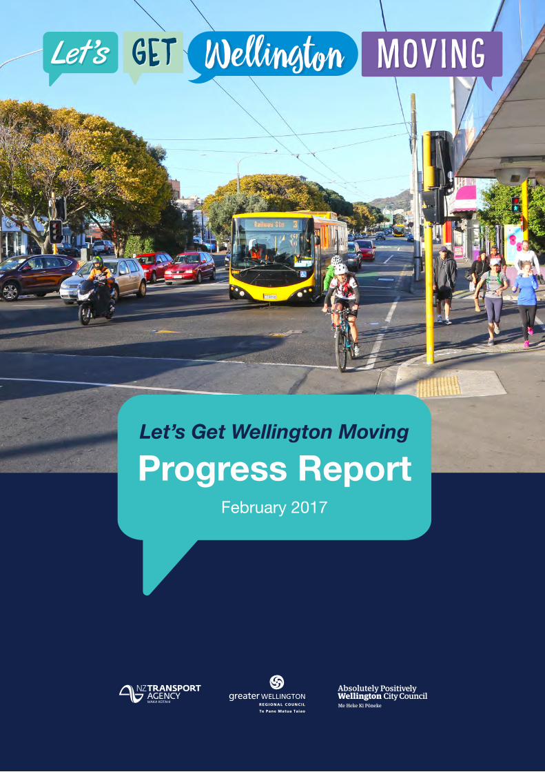
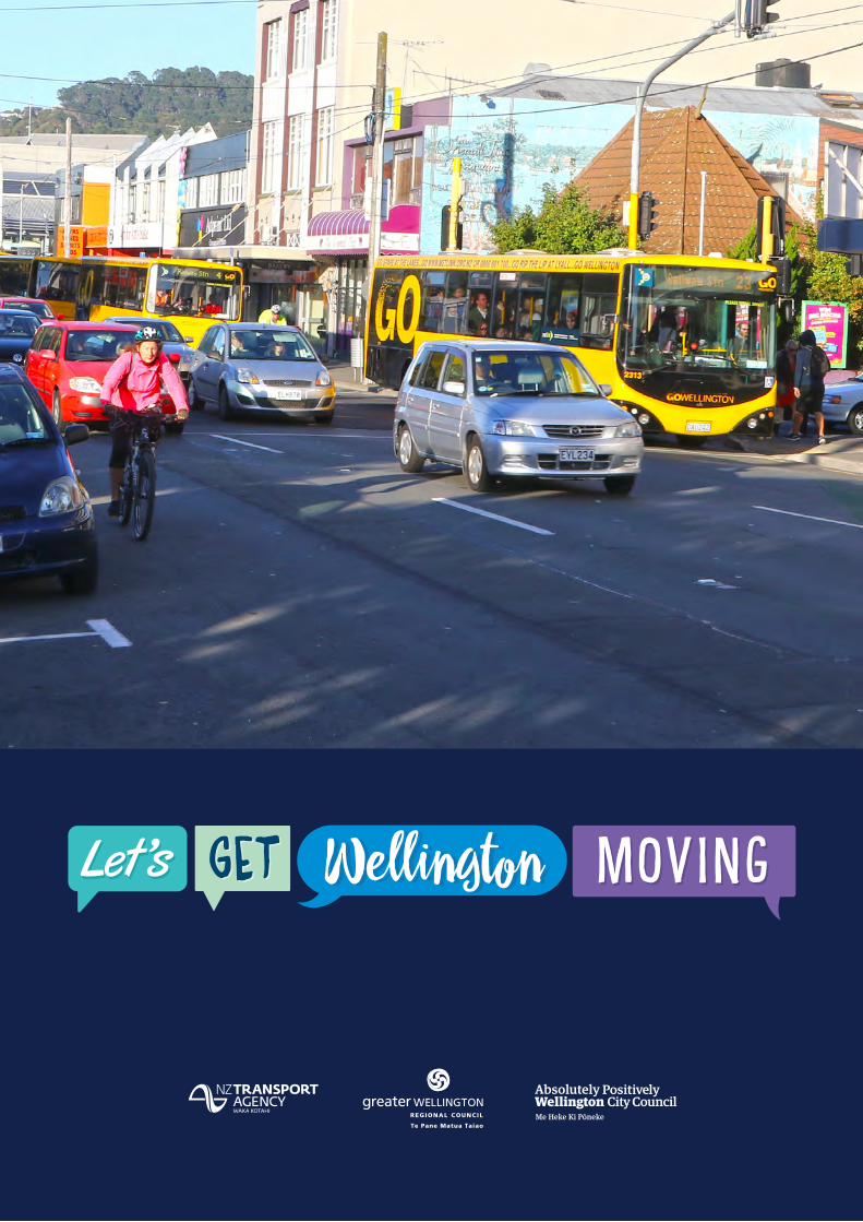
Let’s Get Wellington Moving
Progress ReportFebruary 2017
Let’s Get Wellington Moving – Progress Report February 2017 Let’s Get Wellington Moving – Progress Report February 2017PAGE 2 PAGE 3
ContentsForeword ......................................................................................................................................................................... 3
Executive summary ....................................................................................................................................................... 4
1. Introduction ................................................................................................................................................................. 8
Purpose of this report ....................................................................................................................................................... 8
What is Let’s Get Wellington Moving? ............................................................................................................................. 8
Our focus .......................................................................................................................................................................... 9
2. People first ............................................................................................................................................................... 10
Collaborating with the community ................................................................................................................................. 10
Learnings ........................................................................................................................................................................ 10
Our guiding principles .................................................................................................................................................... 11
3. Comprehensive data collection ............................................................................................................................. 12
Data collection sites ....................................................................................................................................................... 12
4. Wellington growth and travel patterns ................................................................................................................... 13
Growth across the region and in Wellington City .......................................................................................................... 14
Where and how people travel ........................................................................................................................................ 14
5. Defining the problem ................................................................................................................................................ 15
Characteristics of the Wellington transport system ....................................................................................................... 15
Pressing issues .............................................................................................................................................................. 16
6. Finding a solution ..................................................................................................................................................... 20
Overview of approach .................................................................................................................................................... 20
Ongoing engagement ..................................................................................................................................................... 22
Identifying a preferred solution ....................................................................................................................................... 22
In summary ..................................................................................................................................................................... 22
Appendix A: Key strategic documents for Wellington .............................................................................................. 23
Appendix B: Who we are – Let’s Get Wellington Moving programme team ........................................................... 24
Let’s Get Wellington Moving – Progress Report February 2017 Let’s Get Wellington Moving – Progress Report February 2017PAGE 2 PAGE 3
ForewordWellington is a great place to live, work and visit, and there is significant opportunity to capitalise on the compactness of Wellington’s CBD and its natural, social and cultural assets. However, the transport system is starting to impact negatively on Wellington City with flow-on effects for the rest of the region. Improvements are needed to make it work better for people and businesses.
The Let’s Get Wellington Moving programme is about improving the outcomes of liveability, economic growth and productivity, safety and resilience. It is taking a whole of system approach to examining transport between Ngauranga and the airport, and its interaction with land use.
Wellington’s transport system is constrained by geography and shaped by previous investment decisions.
Key routes into and through the CBD are often heavily congested, resulting in delays and unreliable journey times for people and goods accessing the CBD and other important regional destinations like the port, airport and hospital. State Highway 1 runs through the CBD to the airport, creating conflict in a high growth area with heavy pedestrian activity. Some bus priority is provided along the Golden Mile but it is not consistent across the CBD or wider city, and bus travel times are slow and unreliable.
Whilst Wellington’s compact urban form encourages pedestrian activity, there are many potential points of conflict with vehicles. Infrastructure for cycling in the central city is currently limited, resulting in safety issues and a very poor level of service for cyclists. Network constraints in terms of space and limited alternative routes mean that the transport system has poor resilience, contributing to delays as a result of unplanned network disruptions.
If action is not taken, travel conditions in and around the Wellington CBD are likely to get worse as population and employment grow. The CBD will continue to be the main employment centre of the region with at least 20,000 more jobs expected in the next 30 years. Wellington City Council is planning for almost 50,000 more people to live in the city over the next 30 years, with approximately 15,000 of these living in the CBD.
Continued growth will depend on the competitiveness of the city and its ability to attract people with a range of specialist skills to create a labour market that will encourage business investment and support the prosperity of the wider region. The liveability of central Wellington is critical for this to happen. To improve Wellington’s liveability, the transport system must fit with our natural and urban environment and enable people to get around safely and easily by all modes.
Let’s Get Wellington Moving provides the opportunity to develop a Wellington transport system that delivers on this. Let’s take it!
Barry Mein
Let’s Get Wellington Moving Programme Director

Let’s Get Wellington Moving – Progress Report February 2017 Let’s Get Wellington Moving – Progress Report February 2017PAGE 4 PAGE 5
What outcomes are we seeking?What outcomes are we seeking?
What are our objectives?A transport sytem that...
Liveability Economic growth and productivity
Safety Resilience
Enhances the
liveability of the
central city
Provides more
efficient and reliable access for all users
Reduces reliance
on private vehicle travel
Improves safety for all users
Is adaptable
to disruptions and future uncertainty
There will be trade-offs between these different objectives, reflecting the diverse interests in our community.
Objectives and outcomes
Executive summary Unlocking Wellington’s potential is at the heart of Let’s Get Wellington Moving. We want to make sure this city remains one of the best places in the world to live.
Let’s Get Wellington Moving is a joint initiative between Wellington City Council, Greater Wellington Regional Council, and the NZ Transport Agency (the programme partners). Together, we’re working with the people of Wellington to deliver an integrated transport system that supports their aspirations for how Wellington City looks, feels and functions.
People need to be able to get around the CBD safely and easily by walking, cycling or travelling by car or public transport.
A key consideration is how the transport system interacts with our natural and urban environment and supports future growth.
Let’s Get Wellington Moving takes into account other transport initiatives that are underway and fits within the context of the region’s guiding strategic documents.
This report on the Let’s Get Wellington Moving programme provides an update on the progress we’re making to improve Wellington City’s transport system.
As the diagram on the facing page shows, it brings together two key streams of information that are vital inputs to the programme:
• Feedback from the people of Wellington including the wider regional community and key stakeholders
• Comprehensive data collected on the network including where and how people travel.
The progress report explains how this information has been used to help identify the problems with our current transport system and move towards finding a solution.

Let’s Get Wellington Moving – Progress Report February 2017 Let’s Get Wellington Moving – Progress Report February 2017PAGE 4 PAGE 5
2,500 ideas
Final short list
Testing
Draft short list
Assessment criteria applied
Long list of scenarios
List of possible interventions and improvements
Our guiding principles
Objectives and assessment criteria
Preferred solutionPreferred solutionPreferred solutionPreferred solutionPreferred solutionPreferred solution
Implementation plan
Public feedback
Engagement and feedback
Communityvoice
10,000 responses
You & me
Key stakeholders
Comprehensive data collection

Let’s Get Wellington Moving – Progress Report February 2017 Let’s Get Wellington Moving – Progress Report February 2017PAGE 6 PAGE 7
People first – collaborating with the communityThis is about designing our transport system around the wants and needs of people. In April and May 2016, we invited people across the region to share what they love about Wellington City and what frustrates them most about getting around it. More than 10,000 people joined the conversation. This provided Let’s Get Wellington Moving with 2,500 ideas, suggestions and options for improvements. It helped us understand the problems people face day to day as they walk, cycle, use public transport or drive around the city.
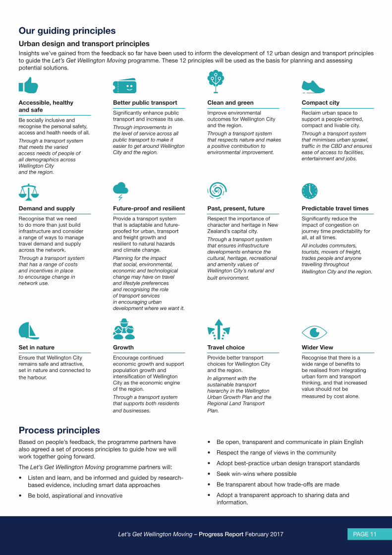
Insights we’ve gained from the feedback so far have been used to help develop a set of 12 urban design and transport principles to guide the Let’s Get Wellington Moving programme. We’ve also agreed a set of “process” principles to guide how we will work together going forward.
Our guiding principles
Accessible and safe
Better public transport
Clean and green
Compact city
Demand and supply
Future proof and resilient
Past, present, future
Predictable travel times
Set in nature Growth Travel choice Wider view
Comprehensive data collection We’ve collected a wealth of data from different sources on where, when and how people travel around Wellington City. Additional information has been gathered on the reliability of journey times. This has built an excellent evidence base to inform decisions about possible improvements.
Our focusOur focus is the area of Wellington City shown in this map, known as the Ngauranga to Airport corridor. It runs from Ngauranga Gorge to the airport and provides regional access to important destinations including the CBD, port, airport and Wellington Regional Hospital, and provides connections to the southern and eastern suburbs.
In particular we want to make it easier to move:
• In and out of the Wellington CBD
• Through the CBD
• Around the CBD.
Focus area (indicative)
Image source: Land Information New Zealand (LINZ
“Improve cross-city access for all modes of travel.”
Let’s Get Wellington Moving – Progress Report February 2017 Let’s Get Wellington Moving – Progress Report February 2017PAGE 6 PAGE 7
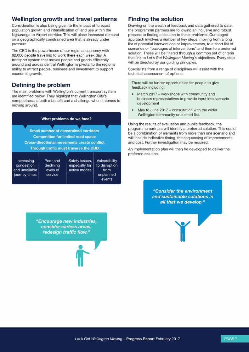
Wellington growth and travel patternsConsideration is also being given to the impact of forecast population growth and intensification of land use within the Ngauranga to Airport corridor. This will place increased demand on a geographically constrained area that is already under pressure.
The CBD is the powerhouse of our regional economy with 82,000 people travelling to work there each week day. A transport system that moves people and goods efficiently around and across central Wellington is pivotal to the region’s ability to attract people, business and investment to support economic growth.
Defining the problemThe main problems with Wellington’s current transport system are identified below. They highlight that Wellington City’s compactness is both a benefit and a challenge when it comes to moving around.
What problems do we face?
Small number of constrained corridors
Competition for limited road space
Cross-directional movements create conflict
Through traffic must traverse the CBD
Increasing congestion
and unreliable journey times
Poor and declining levels of service
Safety issues, especially for active modes
Vulnerability to disruption
from unplanned
events
Finding the solutionDrawing on the wealth of feedback and data gathered to date, the programme partners are following an inclusive and robust process to finding a solution to these problems. Our staged approach involves a number of key steps, moving from a long list of potential interventions or improvements, to a short list of scenarios or “packages of interventions” and then to a preferred solution. These will be filtered through a common set of criteria that link to Let’s Get Wellington Moving’s objectives. Every step will be directed by our guiding principles.
Specialists from a range of disciplines will assist with the technical assessment of options.
There will be further opportunities for people to give feedback including:
• March 2017 – workshops with community and business representatives to provide input into scenario development
• May to June 2017 – consultation with the wider Wellington community on a short list.
Using the results of evaluation and public feedback, the programme partners will identify a preferred solution. This could be a combination of elements from more than one scenario and will include indicative timing, the sequencing of improvements, and cost. Further investigation may be required.
An implementation plan will then be developed to deliver the preferred solution.
“Consider the environment and sustainable solutions in
all that we develop.”
“Encourage new industries, consider carless areas, redesign traffic flow.”
Let’s Get Wellington Moving – Progress Report February 2017 Let’s Get Wellington Moving – Progress Report February 2017PAGE 8 PAGE 9
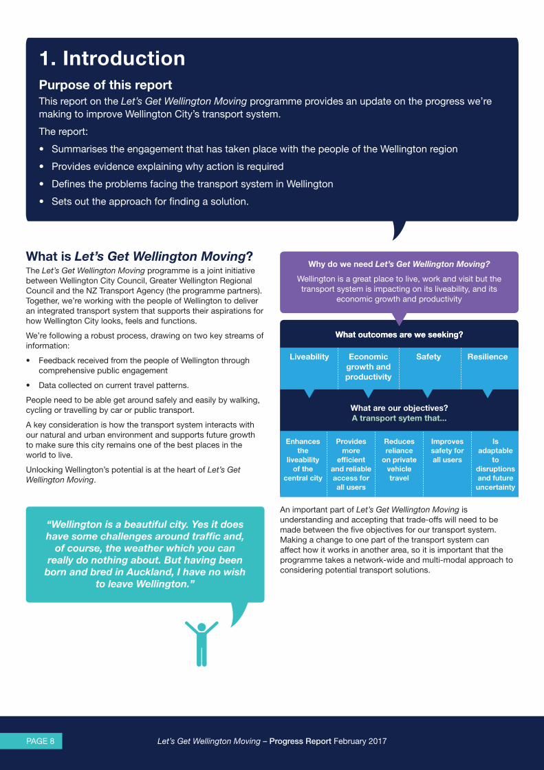
1. IntroductionPurpose of this reportThis report on the Let’s Get Wellington Moving programme provides an update on the progress we’re making to improve Wellington City’s transport system.
The report:
• Summarises the engagement that has taken place with the people of the Wellington region
• Provides evidence explaining why action is required
• Defines the problems facing the transport system in Wellington
• Sets out the approach for finding a solution.
What is Let’s Get Wellington Moving? The Let’s Get Wellington Moving programme is a joint initiative between Wellington City Council, Greater Wellington Regional Council and the NZ Transport Agency (the programme partners). Together, we’re working with the people of Wellington to deliver an integrated transport system that supports their aspirations for how Wellington City looks, feels and functions.
We’re following a robust process, drawing on two key streams of information:
• Feedback received from the people of Wellington through comprehensive public engagement
• Data collected on current travel patterns.
People need to be able get around safely and easily by walking, cycling or travelling by car or public transport.
A key consideration is how the transport system interacts with our natural and urban environment and supports future growth to make sure this city remains one of the best places in the world to live.
Unlocking Wellington’s potential is at the heart of Let’s Get Wellington Moving.
An important part of Let’s Get Wellington Moving is understanding and accepting that trade-offs will need to be made between the five objectives for our transport system. Making a change to one part of the transport system can affect how it works in another area, so it is important that the programme takes a network-wide and multi-modal approach to considering potential transport solutions.
What outcomes are we seeking?What outcomes are we seeking?
What are our objectives?A transport sytem that...
Liveability Economic growth and productivity
Safety Resilience
Why do we need Let’s Get Wellington Moving?
Wellington is a great place to live, work and visit but the transport system is impacting on its liveability, and its
economic growth and productivity
Enhances the
liveability of the
central city
Provides more
efficient and reliable access for all users
Reduces reliance
on private vehicle travel
Improves safety for all users
Is adaptable
to disruptions and future uncertainty
“Wellington is a beautiful city. Yes it does have some challenges around traffic and,
of course, the weather which you can really do nothing about. But having been
born and bred in Auckland, I have no wish to leave Wellington.”

Let’s Get Wellington Moving – Progress Report February 2017 Let’s Get Wellington Moving – Progress Report February 2017PAGE 8 PAGE 9
Our focusOur focus is the area of Wellington City shown in this map, known as the Ngauranga to Airport corridor. It runs from Ngauranga Gorge to the airport and provides regional access to important destinations including the CBD, port, airport and Wellington Regional Hospital, and provides connections to the southern and eastern suburbs.
In particular we want to make it easier for people to move:
• In and out of the Wellington CBD
• Through the CBD
• Around the CBD.
Figure 1: Let’s Get Wellington Moving Focus Area
Let’s Get Wellington Moving is exploring a broad range of potential interventions or improvements spanning the demand, supply and optimisation of transport services and infrastructure and their interaction with land use. These include changes to the strategic and local road network, public transport services, and cycling and pedestrian networks and facilities.
Let’s Get Wellington Moving takes into account other transport initiatives that are underway in the focus area, including changes to regional bus services, improvements to cycling infrastructure and ongoing development of urban spaces in the CBD. In addition, there are improvements being made to the State Highway network and regional rail network outside of the focus area that will impact on Let’s Get Wellington Moving. The programme partners will take these into account when assessing potential solutions to Wellington’s transport problems.
Let’s Get Wellington Moving fits within the context of the region’s guiding strategic documents and Wellington City Council’s vision for growth. See Appendix A.
This timeline shows the key phases of the programme and where we are now.
May – June 2016
Survey the region – what matters to people and
how they move around
August 2016
Use information to develop a set of urban design and transport principles
Nov 2016 – March 2017
Develop and test a range of different scenarios against programme
objectives and assessment criteria
May – June 2017
Consult on scenario short list
July 2017
Use the results of evaluation and public
feedback to identify a preferred solution as the basis for an
implementation plan
Timeline
WE ARE HERE
Focus area (indicative)
Image source: Land Information New Zealand (LINZ
Let’s Get Wellington Moving – Progress Report February 2017 Let’s Get Wellington Moving – Progress Report February 2017PAGE 10 PAGE 11
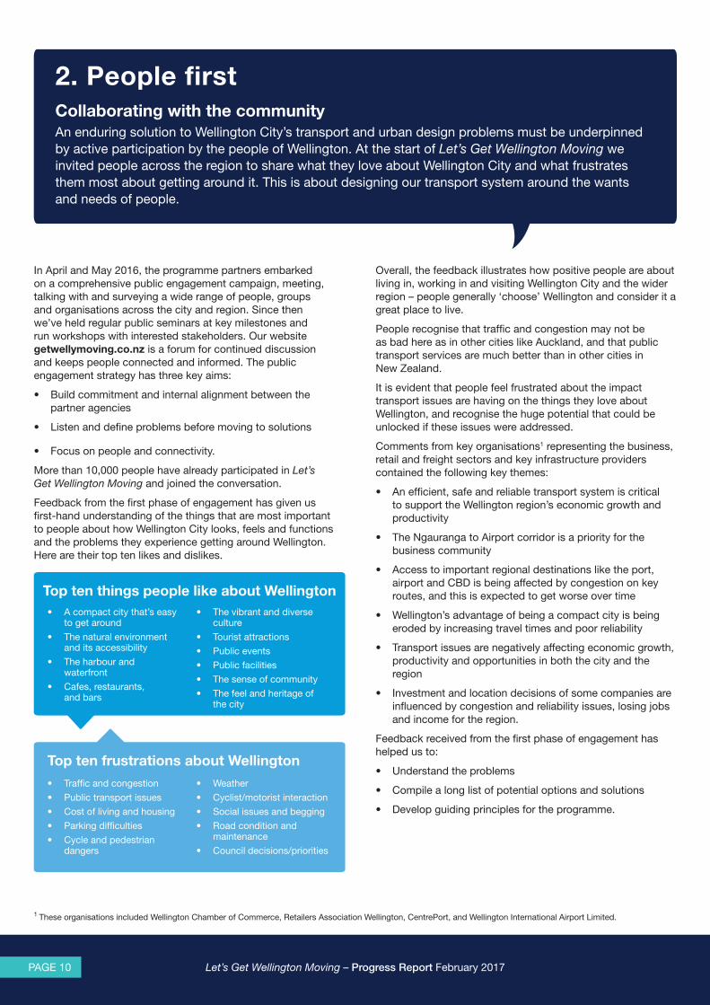
2. People first Collaborating with the communityAn enduring solution to Wellington City’s transport and urban design problems must be underpinned by active participation by the people of Wellington. At the start of Let’s Get Wellington Moving we invited people across the region to share what they love about Wellington City and what frustrates them most about getting around it. This is about designing our transport system around the wants and needs of people.
In April and May 2016, the programme partners embarked on a comprehensive public engagement campaign, meeting, talking with and surveying a wide range of people, groups and organisations across the city and region. Since then we’ve held regular public seminars at key milestones and run workshops with interested stakeholders. Our website getwellymoving.co.nz is a forum for continued discussion and keeps people connected and informed. The public engagement strategy has three key aims:
• Build commitment and internal alignment between the partner agencies
• Listen and define problems before moving to solutions
• Focus on people and connectivity.
More than 10,000 people have already participated in Let’s Get Wellington Moving and joined the conversation.
Feedback from the first phase of engagement has given us first-hand understanding of the things that are most important to people about how Wellington City looks, feels and functions and the problems they experience getting around Wellington. Here are their top ten likes and dislikes.
Overall, the feedback illustrates how positive people are about living in, working in and visiting Wellington City and the wider region – people generally ‘choose’ Wellington and consider it a great place to live.
People recognise that traffic and congestion may not be as bad here as in other cities like Auckland, and that public transport services are much better than in other cities in New Zealand.
It is evident that people feel frustrated about the impact transport issues are having on the things they love about Wellington, and recognise the huge potential that could be unlocked if these issues were addressed.
Comments from key organisations1 representing the business, retail and freight sectors and key infrastructure providers contained the following key themes:
• An efficient, safe and reliable transport system is critical to support the Wellington region’s economic growth and productivity
• The Ngauranga to Airport corridor is a priority for the business community
• Access to important regional destinations like the port, airport and CBD is being affected by congestion on key routes, and this is expected to get worse over time
• Wellington’s advantage of being a compact city is being eroded by increasing travel times and poor reliability
• Transport issues are negatively affecting economic growth, productivity and opportunities in both the city and the region
• Investment and location decisions of some companies are influenced by congestion and reliability issues, losing jobs and income for the region.
Feedback received from the first phase of engagement has helped us to:
• Understand the problems
• Compile a long list of potential options and solutions
• Develop guiding principles for the programme.
Top ten things people like about Wellington
Top ten frustrations about Wellington
• A compact city that’s easy to get around
• The natural environment and its accessibility
• The harbour and waterfront
• Cafes, restaurants, and bars
• The vibrant and diverse culture
• Tourist attractions • Public events • Public facilities • The sense of community • The feel and heritage of
the city
• Traffic and congestion • Public transport issues • Cost of living and housing • Parking difficulties • Cycle and pedestrian
dangers
• Weather • Cyclist/motorist interaction • Social issues and begging • Road condition and
maintenance • Council decisions/priorities
1 These organisations included Wellington Chamber of Commerce, Retailers Association Wellington, CentrePort, and Wellington International Airport Limited.
Let’s Get Wellington Moving – Progress Report February 2017 Let’s Get Wellington Moving – Progress Report February 2017PAGE 10 PAGE 11
Our guiding principlesUrban design and transport principlesInsights we’ve gained from the feedback so far have been used to inform the development of 12 urban design and transport principles to guide the Let’s Get Wellington Moving programme. These 12 principles will be used as the basis for planning and assessing potential solutions.
Set in nature
Ensure that Wellington City remains safe and attractive, set in nature and connected to the harbour.
Growth
Encourage continued economic growth and support population growth and intensification of Wellington City as the economic engine of the region.
Through a transport system that supports both residents and businesses.
Travel choice
Provide better transport choices for Wellington City and the region.
In alignment with the sustainable transport hierarchy in the Wellington Urban Growth Plan and the Regional Land Transport Plan.
Wider View
Recognise that there is a wide range of benefits to be realised from integrating urban form and transport thinking, and that increased value should not be measured by cost alone.
Demand and supply
Recognise that we need to do more than just build infrastructure and consider a range of ways to manage travel demand and supply across the network.
Through a transport system that has a range of costs and incentives in place to encourage change in network use.
Future-proof and resilient
Provide a transport system that is adaptable and future-proofed for urban, transport and freight growth and resilient to natural hazards and climate change.
Planning for the impact that social, environmental, economic and technological change may have on travel and lifestyle preferences and recognising the role of transport services in encouraging urban development where we want it.
Past, present, future
Respect the importance of character and heritage in New Zealand’s capital city.
Through a transport system that ensures infrastructure developments enhance the cultural, heritage, recreational and amenity values of Wellington City’s natural and built environment.
Predictable travel times
Significantly reduce the impact of congestion on journey time predictability for all, at all times.
All includes commuters, tourists, movers of freight, trades people and anyone travelling throughout Wellington City and the region.
Accessible, healthy and safe
Be socially inclusive and recognise the personal safety, access and health needs of all.
Through a transport system that meets the varied access needs of people of all demographics across Wellington City and the region.
Better public transport
Significantly enhance public transport and increase its use.
Through improvements in the level of service across all public transport to make it easier to get around Wellington City and the region.
Clean and green
Improve environmental outcomes for Wellington City and the region.
Through a transport system that respects nature and makes a positive contribution to environmental improvement.
Compact city
Reclaim urban space to support a people-centred, compact and livable city.
Through a transport system that minimises urban sprawl, traffic in the CBD and ensures ease of access to facilities, entertainment and jobs.
Process principlesBased on people’s feedback, the programme partners have also agreed a set of process principles to guide how we will work together going forward.
The Let’s Get Wellington Moving programme partners will:
• Listen and learn, and be informed and guided by research-based evidence, including smart data approaches
• Be bold, aspirational and innovative
• Be open, transparent and communicate in plain English
• Respect the range of views in the community
• Adopt best-practice urban design transport standards
• Seek win-wins where possible
• Be transparent about how trade-offs are made
• Adopt a transparent approach to sharing data and information.

Let’s Get Wellington Moving – Progress Report February 2017 Let’s Get Wellington Moving – Progress Report February 2017PAGE 12 PAGE 13
MULTIMODAL, CITYWIDE VIEWWeekday and weekend
Use of technology
Automatic Number Plate Recognition (ANPR), Bluetooth, GPS
FLOW DATA Traffic counts | Cycle counts
Pedestrian counts | Turning movements
Video footage (queue lengths)
NETWORK PERFORMANCE Bluetooth data for travel times / delay / variability
GPS data for travel times / delay / variability
Public Transport travel times / delay / variability
ORIGIN – DESTINATION / DEMAND ANPR Origin – Destination
Census Journey To Work
Data collection sites
3. Comprehensive data collection In addition to being people-centred, Let’s Get Wellington Moving is evidence-driven. To better understand the problems with Wellington City’s current transport system the programme partners have collected a wealth of data from different sources. This includes traffic counts for private vehicles, cyclists, pedestrians, turning movements and video footage of queue lengths. We’ve also looked at demand on the network in terms of the origin and/or destination of traffic, using Automatic Number Plate Recognition (APNR) and NZ Statistics Census Journey to Work data. Bluetooth and GPS data, and Real Time Passenger Information data have provided further insights into travel times, delay and variability.
Data sources
Let’s Get Wellington Moving – Progress Report February 2017 Let’s Get Wellington Moving – Progress Report February 2017PAGE 12 PAGE 13
Wellington
Lower Hutt
South Wairarapa
Upper Hutt
Masterton
Kapiti Coast
Tararua
Porirua
Carterton
Focus area (indicative)
CBD (indicative)
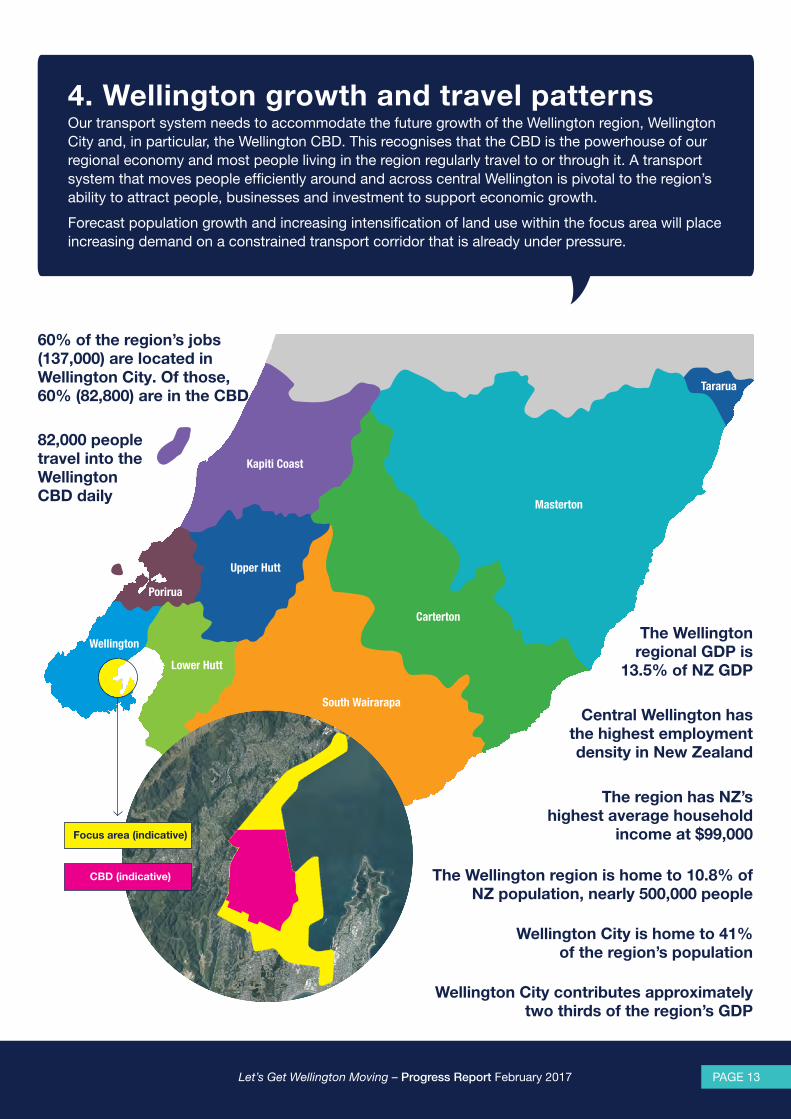
4. Wellington growth and travel patterns Our transport system needs to accommodate the future growth of the Wellington region, Wellington City and, in particular, the Wellington CBD. This recognises that the CBD is the powerhouse of our regional economy and most people living in the region regularly travel to or through it. A transport system that moves people efficiently around and across central Wellington is pivotal to the region’s ability to attract people, businesses and investment to support economic growth.
Forecast population growth and increasing intensification of land use within the focus area will place increasing demand on a constrained transport corridor that is already under pressure.
82,000 people travel into the Wellington CBD daily
The Wellington region is home to 10.8% of NZ population, nearly 500,000 people
60% of the region’s jobs (137,000) are located in Wellington City. Of those, 60% (82,800) are in the CBD
Wellington City is home to 41% of the region’s population
Wellington City contributes approximately two thirds of the region’s GDP
The Wellington regional GDP is
13.5% of NZ GDP
Central Wellington has the highest employment density in New Zealand
The region has NZ’s highest average household
income at $99,000

Let’s Get Wellington Moving – Progress Report February 2017 Let’s Get Wellington Moving – Progress Report February 2017PAGE 14 PAGE 15
Growth across the region and in Wellington City The Wellington region has approximately 487,000 residents (2013) and over 40% of these are based in Wellington City. Wellington continues to grow as more people make both the region and, in particular, the city continue to grow as more people are attracted by work opportunities, a vibrant lifestyle and culture, high-quality services and close proximity to natural areas.
The region’s population is forecast to increase by another 60,000 people (12.6%) over the 30 years between 2013 and 2043. Wellington City alone is projected to have approximately 250,000 people by 2043, an increase of approximately 46,000 people (23.1%). The CBD, Te Aro, Pipitea and Thorndon, the Adelaide Road corridor, and Newtown are key growth areas. Wellington City Council expects the residential population of the CBD to grow by at least 15,000 people over the next 30 years.
The Council plans to accommodate population and economic growth through regeneration and intensification in existing urban areas that have transport links, infrastructure and community facilities, with limited urban expansion into greenfield areas.
Wellington City is the home of major regional facilities, such as the airport, Wellington Regional Hospital, the regional stadium, and CentrePort. Ensuring easy access to these facilities in the face of a growing population is a challenge.
Wellington International Airport anticipates passenger numbers to more than double between 2010 and 2030, while Wellington Regional Hospital is forecasting that hospital discharges will increase by 18.5% by 2026.
Looking forward, the Wellington regional economy is expected to become more diverse, building its strength across a broad range of sectors, particularly innovation, research and development and information technology. Wellington’s economy is increasingly creative, knowledge-based and ‘weightless’.
The greatest growth in employment across the region is forecast to occur in Wellington City, with an additional 23,600 jobs projected out to 20432. If recent trends continue employment and population growth are likely to exceed current projections.
Where and how people travel The transport network and urban development in the Wellington region is geographically constrained, and contained mainly in a few narrow corridors. From the air Wellington’s regional strategic road and rail network resembles a ‘Y’ reflecting the western (SH1) and eastern (SH2) corridors which meet at the bottom of Ngauranga Gorge. Nearly 60% of the region’s jobs are located in the Wellington CBD so a large proportion of journeys are to and from here. It’s the key destination.
Approximately 82,000 people travel to or through the Wellington CBD in the morning peak, with over half arriving from north Wellington and the rest of the region.There is an almost even split between travel by car and other modes of transport. Rail is a popular choice for people coming into the CBD from the north. Around a quarter of people walk to work from the western, eastern and southern suburbs.
Of the 4,200 people exiting the Terrace Tunnel in the morning peak only 25% continue as far as Mt Victoria tunnel
Of the 3,200 people who travel southbound on Aotea Quay in the
morning peak, 800 (25%) use it as a through route
2 Greater Wellington Regional Council, TN11 WTSM 2013 Demographic Report, page 23.
3 Wellington CBD Cordon Survey, March 2016
“A major advantage Wellington has over other cities for business is the
convenient location of the airport. If this is undermined by congestion, Wellington
will lose a competitive advantage.”
Image source: Land Information New Zealand (LINZ
NORTH (rest of region)
42,000
WEST14,000
SOUTH13,000
EAST13,000
Car occupants
Bus passengers
Rail passengers
Cyclists
Pedestrians
KEY
Figure 2: Volume by mode of travel entering the Wellington CBD, AM peak March 20163
Let’s Get Wellington Moving – Progress Report February 2017 Let’s Get Wellington Moving – Progress Report February 2017PAGE 14 PAGE 15
5. Defining the problemListening to the people of Wellington and looking at the hard data that the programme partners have collected, the Let’s Get Wellington Moving team has identified a number of outstanding problems with Wellington City’s current transport system. They are all inter-related. The main problems are summarised below then explained more fully.
Characteristics of the Wellington transport systemWellington City’s topography with hills and the waterfront surrounding the central area has shaped the transport system. There is little room to increase road space within the CBD without affecting on the existing built environment.
While Wellington’s compact urban form encourages pedestrian activity and cycling, there are many potential points of conflict with vehicles.
Constrained corridors mean there is competition for limited road space between people walking, cycling, or travelling by bus or car or making goods deliveries. Parking further encroaches on this limited space.
Wellington is a great place to live, work and visit but the transport system is impacting on its liveability,
and its economic growth and productivity
What problems do we face?
Small number of constrained corridors
Competition for limited road space
Cross-directional movements create conflict
Through traffic must traverse the CBD
Increasing congestion
and unreliable journey times
Poor and declining levels of service
Safety issues, especially for active modes
Vulnerability to disruption
from unplanned
events
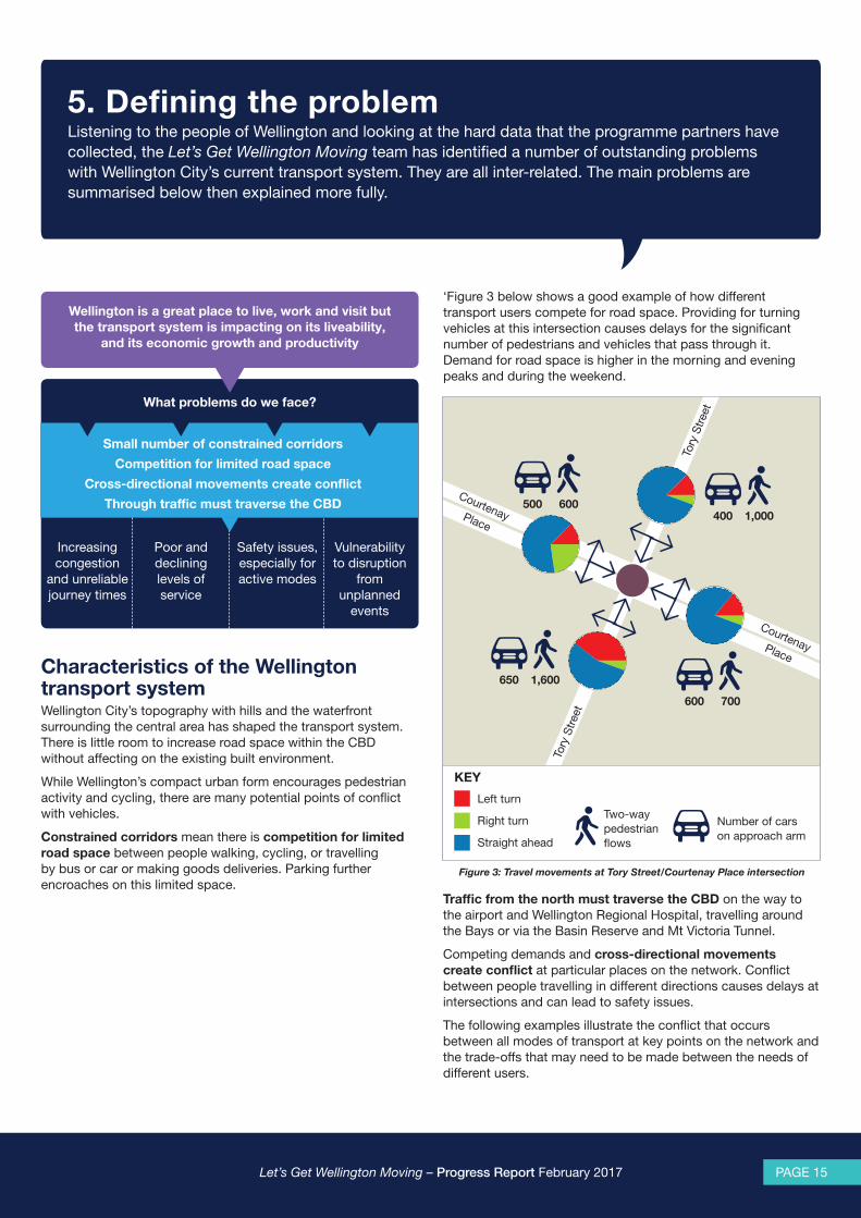
‘Figure 3 below shows a good example of how different transport users compete for road space. Providing for turning vehicles at this intersection causes delays for the significant number of pedestrians and vehicles that pass through it. Demand for road space is higher in the morning and evening peaks and during the weekend.
Figure 3: Travel movements at Tory Street/Courtenay Place intersection
Traffic from the north must traverse the CBD on the way to the airport and Wellington Regional Hospital, travelling around the Bays or via the Basin Reserve and Mt Victoria Tunnel.
Competing demands and cross-directional movements create conflict at particular places on the network. Conflict between people travelling in different directions causes delays at intersections and can lead to safety issues.
The following examples illustrate the conflict that occurs between all modes of transport at key points on the network and the trade-offs that may need to be made between the needs of different users.
Courtenay Place
Courtenay Place
Tory
Stre
et
Tory
Stre
et
700
1,600
1,000600
600
650
500400
Left turn
Right turn
Straight ahead
KEY
Number of cars on approach arm
Two-way pedestrian flows
Let’s Get Wellington Moving – Progress Report February 2017 Let’s Get Wellington Moving – Progress Report February 2017PAGE 16 PAGE 17
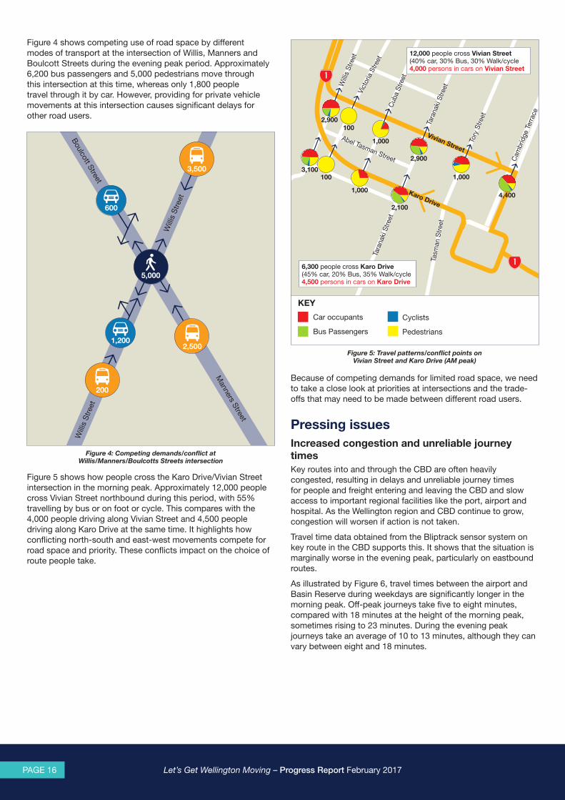
Figure 4 shows competing use of road space by different modes of transport at the intersection of Willis, Manners and Boulcott Streets during the evening peak period. Approximately 6,200 bus passengers and 5,000 pedestrians move through this intersection at this time, whereas only 1,800 people travel through it by car. However, providing for private vehicle movements at this intersection causes significant delays for other road users.
Figure 5 shows how people cross the Karo Drive/Vivian Street intersection in the morning peak. Approximately 12,000 people cross Vivian Street northbound during this period, with 55% travelling by bus or on foot or cycle. This compares with the 4,000 people driving along Vivian Street and 4,500 people driving along Karo Drive at the same time. It highlights how conflicting north-south and east-west movements compete for road space and priority. These conflicts impact on the choice of route people take.
Figure 5: Travel patterns/conflict points on Vivian Street and Karo Drive (AM peak)
Figure 4: Competing demands/conflict at Willis/Manners/Boulcotts Streets intersection
Because of competing demands for limited road space, we need to take a close look at priorities at intersections and the trade-offs that may need to be made between different road users.
Pressing issues Increased congestion and unreliable journey times Key routes into and through the CBD are often heavily congested, resulting in delays and unreliable journey times for people and freight entering and leaving the CBD and slow access to important regional facilities like the port, airport and hospital. As the Wellington region and CBD continue to grow, congestion will worsen if action is not taken.
Travel time data obtained from the Bliptrack sensor system on key route in the CBD supports this. It shows that the situation is marginally worse in the evening peak, particularly on eastbound routes.
As illustrated by Figure 6, travel times between the airport and Basin Reserve during weekdays are significantly longer in the morning peak. Off-peak journeys take five to eight minutes, compared with 18 minutes at the height of the morning peak, sometimes rising to 23 minutes. During the evening peak journeys take an average of 10 to 13 minutes, although they can vary between eight and 18 minutes.
Cam
brid
ge T
erra
ce
Tory
Stre
et
Tara
naki
Stre
et
Cub
a S
treet
Vict
oria
Stre
et
Will
is S
treet
Tara
naki
Stre
et
Tasm
an S
tree
t
Abel Tasman Street
2,900100
1,000
2,900
1,000
4,400
2,100
1,000
1003,100
Car occupants
Bus Passengers
KEY
Karo Drive
Vivian Street
12,000 people cross Vivian Street (40% car, 30% Bus, 30% Walk/cycle4,000 persons in cars on Vivian Street
6,300 people cross Karo Drive (45% car, 20% Bus, 35% Walk/cycle4,500 persons in cars on Karo Drive
Cyclists
Pedestrians
Boulcott Street
Manners Street
Will
is S
treet
Will
is S
treet
5,000
1,200
200
600
3,500
2,500

Let’s Get Wellington Moving – Progress Report February 2017 Let’s Get Wellington Moving – Progress Report February 2017PAGE 16 PAGE 17
Figure 7 shows travel time variability between the Terrace Tunnel and the Basin Reserve. The afternoon peak starts from around 3pm and tapers off close to 7pm, with journeys taking on average between 7 to 15 minutes, and sometimes as long as 21 minutes. The average off-peak travel time is 5 minutes.
Figure 9: Response to whether Wellington peak traffic volumes are acceptable, Wellington City Resident Satisfaction Survey (2013-2016)
Poor and declining levels of service At a regional level, investment in roads and public transport is delivering improvement in the levels of service for transport users.
However, increasing congestion within the Ngauranga to airport corridor is impacting on all forms of transport travelling to, around and through the Wellington CBD. This is particularly evident for bus services in peak periods. In the morning peak a bus trip from Courtenay Place to Wellington Railway Station can take up to 19 minutes, compared with off-peak trips which can take as little as eight minutes.
Research suggests that passengers place a high level of value on reliable public transport travel times and overall journey time, compared with making the same trip by car. Consequently, unreliable travel times can be a barrier to increasing public transport patronage.
Figure 6: Travel time variability between SH1 Airport and Basin Reserve (March 2016)
Figure 7: Travel time variability between SH1 Terrace Tunnel and Basin Reserve (March 2016)
Travel times are also unreliable on other key strategic routes through the CBD. Journey times from Hutt Road to the Basin Reserve via Aotea Quay and Kent Terrace can vary by as much as 100% of the average travel time throughout the day, as Figure 8 shows.
Figure 8: Hutt Road to Basin Reserve (via Quays and Kent Cambridge Terrace) travel times weekdays (2016)
The evidence is aligns with peoples’ experience of travelling on the transport network. As Figure 9 shows, Wellington residents are increasingly saying that congestion levels are unacceptable.
"Zany quirky city, e.g., Waterfront, Cuba St.
Relatively small city and should be easy to get around
BUT traffic terrible.”
20162013 2014 2015
100%
80%
60%
40%
20%
0%
KEY
Acceptable Not acceptableDon’t know
45% say peak traffic volumes are unacceptable
43% say acceptable
SH1 Airport to Basin ReserveAverage weekday travel times and variability
(15th to 85th percentile) by 15 minute time slice
Time of day
Average travel time
Trav
el ti
me
(Min
utes
)
Time of day
Average travel time
Time of day
Average travel time
SH1 Terrace Tunnel to Basin ReserveAverage weekday travel times and variability
(15th to 85th percentile) by 15 minute time slice
Trav
el ti
me
(Min
utes
)
Hutt Rd to Basin Reserve via Quays/Kent Cambridge Tce Average weekday travel times and variability
(15th to 85th percentile) by 15 minute time slice
Trav
el ti
me
(Min
utes
)

Let’s Get Wellington Moving – Progress Report February 2017 Let’s Get Wellington Moving – Progress Report February 2017PAGE 18 PAGE 19
Safety issues, especially for active modes The NZ Transport Agency’s Communities at Risk Register ranks communities against the national average to allow better targeting of resource to where they’re most needed. Of the territorial authorities in the Wellington region, Wellington City has the highest personal risk level at urban intersections and a rating of medium concern nationally4.
Wellington City has high rates of personal risk for:
• Cyclists
• Pedestrians
• Urban intersections
• Motorcyclists.
In Wellington City speed poses a particular safety risk at intersections and in areas with high pedestrian and cyclist use. There is a strong correlation between the speed at impact and severity of injury.
The following map is based on data extracted from the Transport Agency’s Crash Analysis System for the period April 2011 to March 2016. It shows the ‘hot spots’ on the network for fatal and serious crashes. These are concentrated on key arterial routes, particularly the Willis Street section of the Golden Mile.
Cycling has a number of associated health and wellbeing benefits. However, infrastructure for cycling in the central city is currently limited, resulting in safety issues and a very poor level of service for cyclists. Safety risks are higher for cyclists than for other road users because a crash is more likely to result in death or serious injury. Cyclists in the Wellington region have a greater than average5 risk of being killed or seriously injured while cycling.
Given the high level of personal risk and growing number of cyclists, improving cyclist safety is an issue that needs to be addressed.
Research shows a strong correlation between people’s perception of safety and uptake of cycling6.
A 2015 survey found that 52% of respondents believed that cycling around Wellington City was unsafe7. Only 19% thought it was safe cycling in Wellington City. Similarly, the 2014 Wellington City Council Residents’ Monitoring Survey found that 76% of people surveyed would consider cycling if safe and separate infrastructure was provided.
Vulnerability to disruption from unplanned eventsSpace constraints in terms of space and limited alternative routes in and out of the Wellington CBD mean that our transport system has poor resilience. Unplanned events, whether they are caused by natural hazards or network incidents (such as road crashes) significantly contribute to delays.
A resilient transport system is one which is designed, developed and maintained to be less vulnerable to unexpected events and enables quick recovery. Resilience is also about preparing for the future and being able to respond to opportunities as well as risks8, and the ability of the transport system to adapt to potential future changes in climate patterns, sea levels, travel demands, technologies, fuel types, and lifestyles.
Vulnerability to unplanned events has a major impact on access and mobility across the region. The main routes into Wellington are both seismically vulnerable and at risk from more common events such as slips or flooding. Transport corridors often share space with buildings and utility infrastructure. In a major seismic event, building collapse or utility infrastructure failure might further undermine transport system performance. Planning for these inter-dependencies is vital for resilience and recovery.
A crash or incident in the Ngauranga to Airport corridor can result in the closure of traffic lanes in one or both directions. In addition, the lack of alternative routes north-south and limited east-west connectivity mean that even a relatively minor incident often results in severe delays and disruption to the wider network. Information collected by the Wellington Traffic Operations Centre for the State Highway network shows that there were 438 incidents between the Terrace Tunnel and the airport from 1 July 2015 to 30 June 2016.These were mainly crashes and breakdowns, resulting in significant delays for road users. The average delay was 1.3 hours for a breakdown and 3.7 hours for a crash.
Figure 10: Let’s Get Wellington Moving Focus Area: Fatal, Serious and Minor Crashes (2011-2016)
4 Wellington Regional Land Transport Plan.5 Compared to the New Zealand mean average of people killed or seriously injured per million cycling hours.6 Parkin, J.; Ryley, T. J.; Jones, T. J. (2007). Barriers to cycling: an exploration of quantitative analysis. Civil Engineering: University of Bolton Institutional Repository.7 Greater Wellington Regional Council, Transport Perceptions Survey 2012.8 National Infrastructure Unit, ‘Infrastructure Evidence Base: Resilience’, 2014.

Let’s Get Wellington Moving – Progress Report February 2017 Let’s Get Wellington Moving – Progress Report February 2017PAGE 18 PAGE 19
Climate change and natural hazards
The changing climate means Wellington City needs to adapt to new sea levels and weather patterns. These are already affecting our coastline and low lying parts of the city, damaging seawalls and flooding homes.
Climate change adaptation and mitigation measures will be key aspects of achieving a more resilient city. In 2014/15, ‘transportation sources were responsible for an estimated 60% of Wellington City’s overall emissions. Low Carbon Capital – A Climate Change Action Plan for Wellington 2016-18 sets out Wellington City Council’s plan for actions to reduce this impact and make it easier for residents to have transport choices other than personal vehicles reliant on fossil fuels.
Disruption to the Ngauranga to Petone corridor by natural hazards has been quantified from an economic perspective. Research undertaken on the impact of the 2013 Wellington storm that damaged the rail line and disrupted travel on the state highway estimated its cost to the economy was up to $32 million. This included $5.3 million in cost to local and central government agencies who responded to disruption and damage on the transport network, a $5.3 million loss in value of travel time and between $2 million and $32 million reduction in outputs.
A number of key lifeline locations9 that are critical to enable recovery after a major event have been identified in the focus area. These include Wellington Regional Hospital, CentrePort and Wellington International Airport. Access to the port is particularly vulnerable and presents a significant presents a significant risk which, in turn, is likely to amplify network vulnerability between Ngauranga and Thorndon.
In addition, Greater Wellington Regional Council, in partnership with the NZ Transport Agency and the councils of the region, has identified a prioritised list of transport resilience locations and issues to be progressed. The key lifeline locations and the segments of the network within the Let’s Get Wellington Moving focus area that are at risk from earthquakes, tsunami or storm events are mapped in Figure 11 according to their criticality rating.
Changing technology
To be resilient, our transport system must adopt and adapt to new technologies as they are developed. The Wellington Smart Motorway is an example of using technology to manage traffic flow in and out of Wellington City. Electric vehicles and bikes are increasingly being used on the network, and technology is on a path towards the development of connected and autonomous vehicles. The increased use of smart devices will improve network efficiency through the use of ‘real time’ and ‘just in time’ systems, and by enabling shared mobility will increase. New technologies can make journeys safer and more reliable, move freight more efficiently and reduce network disruption.
9 Wellington Lifelines Group (WeLG) and the Wellington Region Emergency Management Office (WREMO), ‘Restoring Wellington’s transport links after a major earthquake’, 2013.
Figure 11: Network resilience criticality ratings
Image source: Land Information New Zealand (LINZ
SH1 Mt Victoria Tunnel Portal
Aotea Quay Off-ramp
Adelaide Road to Constable Street
Basin Reserve to Vivian Street
Shell Gully
Thorndon to Ngauranga
Aotea Quay to Courtenay Place
Ngaio Gorge Road to Perth Street
Johnsonville Bypass
SH1 Thorndon Overbridge
SH1 Southern Rail Overbridge
CentrePort
Wellington Hospital
Wellington Airport
Petone to Ngauranga
KEY
Criticality Rating
Extreme
Very high
High
Moderate
Low
Lifeline locations
Wakefield Street to Vivian Street
Riddiford Street to Wellington Road
Mt Victoria Tunnel to Cobham Drive
Hutt Road to Featherston Street
Murphy Street to Mulgrave Street
Let’s Get Wellington Moving – Progress Report February 2017 Let’s Get Wellington Moving – Progress Report February 2017PAGE 20 PAGE 21
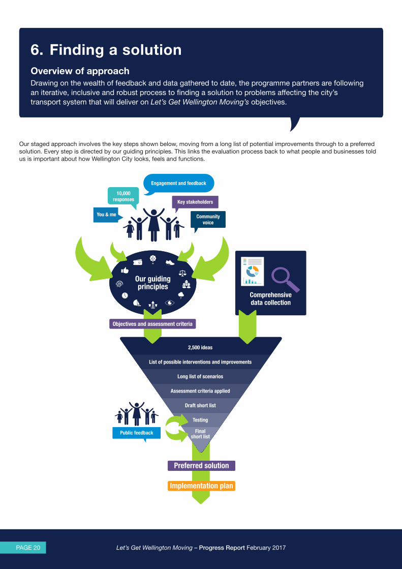
6. Finding a solutionOverview of approachDrawing on the wealth of feedback and data gathered to date, the programme partners are following an iterative, inclusive and robust process to finding a solution to problems affecting the city’s transport system that will deliver on Let’s Get Wellington Moving’s objectives.
Our staged approach involves the key steps shown below, moving from a long list of potential improvements through to a preferred solution. Every step is directed by our guiding principles. This links the evaluation process back to what people and businesses told us is important about how Wellington City looks, feels and functions.
2,500 ideas
Final short list
Testing
Draft short list
Assessment criteria applied
Long list of scenarios
List of possible interventions and improvements
Our guiding principles
Objectives and assessment criteria
Preferred solutionPreferred solutionPreferred solutionPreferred solutionPreferred solutionPreferred solution
Implementation plan
Public feedback
Engagement and feedback
Communityvoice
10,000 responses
You & me
Key stakeholders
Comprehensive data collection

Let’s Get Wellington Moving – Progress Report February 2017 Let’s Get Wellington Moving – Progress Report February 2017PAGE 20 PAGE 21
More than 2,500 ideas have been put forward by the wider Wellington community and key stakeholders in the first phase of public engagement. We’ve pulled out around 250 themes from this feedback. Alongside this we have built a comprehensive picture of how and when people move to, through and across the Wellington CBD through extensive data collection.
Assisted by experts across a range of disciplines, the programme partners have distilled all of this information into a long list of possible transport system interventions.
What is an intervention?Interventions are types of improvements, activities, policies or solutions. They range across all modes of transport. Examples are building new infrastructure, managing travel behaviour through pricing, improving public transport and reducing vehicle traffic in certain areas of the city.
If you think of the interventions as levers, it is possible to pull different levers to a greater or lesser degree to achieve objectives.
These interventions have been grouped into combinations called scenarios.
Assessment criteria
...enhances the liveability of the central cityImproved walkability in the CBD with better access to the waterfrontEnhanced urban environmentReduced impact of motorised transport in CBDMinimised adverse effects on natural environmentMinimised impacts on built environmentNo increase to number of vehicles in the CBD
...provides more efficient and reliable access to support growthIncreased reliability and improved access to and from CBDConsistency with the Urban Growth Plan and Wellington Regional StrategyImproved throughput of people and goods on strategic corridorsIncreased reliability of access to and from the airport, hospital and portReduced PT travel time variability
...improves safety for all usersReduced deaths and serious injuries for road usersImproved safety for pedestrians and cyclists
...that is adaptable to disruptions and future uncertainty Adaptability to be able to respond and recover from unplanned eventsAdaptability and flexibility to cope with future uncertainty and technologies
+ implementabilityConsentingFeasibility
+ costCapital costOperational cost
...reduces reliance on private vehicle travelIncreased PT catchmentImproved pedestrian mode shareImproved cycling mode shareImproved PT mode share
We want a transport system that ...
What is a scenario?Scenarios are a package of different transport and urban design interventions that we think will help improve the way the city looks, feels and functions, make it safe and easy to get around, and support the kind of future growth Wellington wants.
Multi-criteria analysis is being undertaken for each scenario in the long list to arrive at a draft short list of scenarios. The programme team will filter the long list using a set of assessment criteria, based on our 12 urban design and transport principles.
What is multi criteria analysis?Multi-criteria analysis (MCA) is a transparent and repeatable method of weighing up the advantages and disadvantages of the different scenarios, taking account of both tangible and intangible issues.
It involves scoring different scenarios against a range of criteria which reflect the issues that need to be considered.
“I love the city when the traffic is bearable, and you can get around without having to drive in circles trying to find car parking...”
Let’s Get Wellington Moving – Progress Report February 2017 Let’s Get Wellington Moving – Progress Report February 2017PAGE 22 PAGE 23
Both qualitative and quantitative measures are being used to evaluate each scenario against these assessment criteria. For example, for ‘reliable public transport journey times’, a qualitative assessment might consider the degree to which a scenario includes interventions such as more dedicated public transport priority lanes. A quantitative assessment might use a transport model to identify how long a journey might take at different times.
A number of inputs and tools will be used to develop the short list of scenarios, including:
• Constraints mapping and indicative design – will help us to further develop and describe the different interventions that are likely to be included under each scenario.
• Network Operating Framework – will help us to identify and describe how well each scenario package will address the problems and close the ‘gaps’ between how the transport network currently operates and how we would like it to operate.
• Multi Criteria Analysis – will involve more detailed assessment with more emphasis on quantitative measures.
• Transportation models and sensitivity tests – will allow us to understand the impact of the scenarios using a range of measures, including journey times, reliability, mode share, service levels for all modes, congestion, and traffic flows. A number of modelling tools will be used. Sensitivity tests will check the robustness and adaptability of the short listed scenarios under alternative futures (e.g., different growth, land use or technology settings).
It is important to note that no single tool will provide ‘the answers’; a range of tools will help to inform our understanding of the advantages and disadvantages of different scenarios.
This technical assessment phase will involve specialists from a range of disciplines.
Ongoing engagement…Ongoing public engagement will include:
• an online, interactive tool to help people understand the need for trade-offs between diverse interests when assessing scenarios
• workshops with community and business representatives to provide input into scenario development
• consultation with the wider Wellington community on scenario short list.
In March 2017 we plan to run some half-day workshops with participants from both business and community backgrounds. These workshops will help us settle on a short list of scenarios for public consultation.
From May to June there will be an opportunity for the regional community and key stakeholders to provide feedback on the short list of scenarios through a range of channels.
The short listed scenarios will include key information such as their likely contribution to the addressing problems, the main proposed interventions and the key trade-offs and interdependencies they would require if implemented.
This second phase of engagement will seek feedback on the extent to which people and businesses support one or more of the scenarios, and which aspects or key interventions within the different scenarios they would like to see carried forward to a preferred solution.
Identifying a preferred solutionUsing the results of evaluation and public feedback, a preferred solution will be developed by the programme partners. It will also be informed by other considerations such as funding and feasibility.
The preferred solution will identify the indicative staging and sequencing of major interventions and the required level of investment.
Further investigation may be needed before a preferred solution is identified. The preferred solution will not necessarily be one of the short listed scenarios in its original form. It could be a refined version of one scenario or a combination of elements from more than one short listed scenario.
Once the preferred solution has been agreed, an implementation plan will be developed. This will help to guide delivery of the preferred solution, and will include an outline of:
• what will be delivered
• staging and sequencing
• who is responsible for delivery
• funding implications.
In summaryThe programme partners welcome the continued involvement of the wider Wellington community in Let’s Get Wellington Moving as we jointly identify a transport solution that will enhance the special character of Wellington City and reap opportunities for our region and its people.
“Making cyclists share a narrow corridor with fast-moving traffic is unsafe and
thoroughly unreasonable. Build quality infrastructure for active modes and
people will use it. Likewise with buses there needs to be significantly more investment in reserved corridors and
signal priority.”

Let’s Get Wellington Moving – Progress Report February 2017 Let’s Get Wellington Moving – Progress Report February 2017PAGE 22 PAGE 23
Appendix A: Key strategic documents for Wellington Let’s Get Wellington Moving fits within the strategic framework set out in the documents in the table below.
Strategic document Description
Wellington Regional Growth Strategy 2012 A sustainable economic growth strategy set up to enhance the region by building the economy and helping develop Wellington as an internationally competitive region, with a strong CBD and regional centres.
Towards 2040: Smart Capital, WGTN 2040 An overarching strategy that sets out four key objectives for a future Wellington City, that: has a dynamic central city; is an eco-city is people-centred; and is connected.
The Wellington Urban Growth Plan: Urban Development and Transport Strategy 2014-2043
A strategy that seeks to maintain the city’s liveability; keep the city compact, walkable and supported by an efficient transport system; protect the city’s natural setting; and make the city more resilient to natural hazards such as earthquakes and the effects of climate change.
Wellington Regional Land Transport Plan 2015 (including Ngauranga to Wellington Airport Corridor Strategy)
The Plan sets out the long-term strategic vision for the Ngauranga to Airport corridor. This includes providing efficient, reliable, quick and easy access to key destinations such as CentrePort, the Wellington CBD, Wellington Regional Hospital and the the airport; for high quality and reliable public transport along the growth spine and other key commuter routes; a local street network that provides a safe, attractive and accessible environment for pedestrians and cyclists; and a strategic road network that provides an effective corridor for through trips, including freight trips, and for access to key destinations.
Let’s Get Wellington Moving – Progress Report February 2017 Let’s Get Wellington Moving – Progress Report February 2017PAGE 24 PAGE 25
Appendix B: Who we are – Let’s Get Wellington Moving programme teamThe Let’s Get Wellington Moving Programme Team brings together representatives from the three partner agencies: Wellington City Council, Greater Wellington Regional Council and the NZ Transport Agency.
Governance GroupRaewyn Bleakley (NZTA)
Councillor Chris Calvi-Freeman (WCC)
Councillor Barbara Donaldson (GWRC)
Fergus Gammie (NZTA)
Mayor Wayne Guppy (UHCC)
Councillor Chris Laidlaw (GWRC)
Mayor Justin Lester (WCC)
Alliance BoardRaewyn Bleakley (NZTA)
Greg Campbell (GWRC)
Kevin Lavery (WCC)
Programme DirectorBarry Mein
Let’s Get Wellington Moving – Progress Report February 2017 Let’s Get Wellington Moving – Progress Report February 2017PAGE 24 PAGE 25
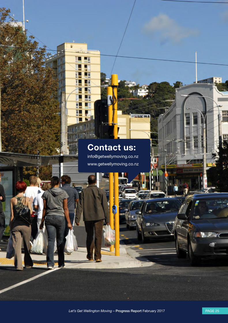
Contact us:[email protected]
www.getwellymoving.co.nz