Embed Size (px)
Citation preview
Level 1 fauna habitat assessment and targeted mulgara survey for the FerrAus Pilbara Project
Prepared for FerrAus Ltd
July 2011
Final Report, Rev 0
Level 1 fauna habitat assessment and targeted mulgara survey for the FerrAus Pilbara Project FerrAus Ltd
Final Report
Phoenix Environmental Sciences Pty Ltd i
Level 1 fauna habitat assessment and targeted mulgara survey for the FerrAus Pilbara Project
Final report, Rev 0
Prepared for FerrAus Ltd
Author/s: Tamara Kabat and Jarrad Clark
Reviewers: Karen Crews, Guillaume Bouteloup
Date: 14/07/2011
Submitted to: Barbara Heemink, Neil Dixon
Chain of authorship and review
Name Task Version Date
Tamara Kabat Draft for technical review 1.0 02/05/2011
Jarrad Clark Technical review 1.1 08/06/2011
Tamara Kabat Draft for technical review 1.2 19/06/2011
Jarrad Clark Technical review 1.3 19/06/2011
Karen Crews Editorial review 1.4 22/06/2011
Tamara Kabat Draft for client comments
1.5 23/06/2011
Guillaume Bouteloup Final for technical review 1.6 04/07/2011
Karen Crews Final submitted to client 1.7 06/07/2011
Guillaume Bouteloup Final submitted to client 1.8 14/07/2011
©Phoenix Environmental Sciences Pty Ltd 2011
The use of this report is solely for the Client for the purpose in which it was prepared. Phoenix Environmental Sciences accepts no responsibility for use beyond this purpose.
All rights are reserved and no part of this report may be reproduced or copied in any form without the written permission of Phoenix Environmental Sciences or FerrAus Limited.
Phoenix Environmental Sciences Pty Ltd
1/511 Wanneroo Rd BALCATTA WA 6021
P: 08 9345 1608
F: 08 6313 0680
Project code: 974-DC-FER-FAU
Level 1 fauna habitat assessment and targeted mulgara survey for the FerrAus Pilbara Project FerrAus Ltd
Final Report
Phoenix Environmental Sciences Pty Ltd ii
CONTENTS
EXECUTIVE SUMMARY ............................................................................................................................ V
1 INTRODUCTION ............................................................................................................................... 1
1.1 Background ............................................................................................................................. 1
1.1.1 Level 1 fauna habitat assessment ................................................................................... 1
1.1.2 Crest-tailed Mulgara (Dasycercus cristicauda) ............................................................... 1
1.2 Scope of work and survey objectives ...................................................................................... 2
2 EXISTING ENVIRONMENT ................................................................................................................ 5
2.1 Interim biogeographic regionalisation of Australia (IBRA) region .......................................... 5
2.2 Land systems ........................................................................................................................... 5
2.3 Climate of the study area and weather during survey period ................................................ 6
2.4 Land use .................................................................................................................................. 8
2.5 Previous surveys ..................................................................................................................... 8
2.6 Relevant legislation and agreements ...................................................................................... 9
3 CREST-TAILED MULGARA LIFE HISTORY AND ECOLOGY ............................................................... 10
3.1 General biology and identification ........................................................................................ 10
3.2 Taxonomy and nomenclature ............................................................................................... 10
3.3 Habitat and distribution ........................................................................................................ 10
3.4 Diet ........................................................................................................................................ 11
3.5 Home range size .................................................................................................................... 12
3.6 Breeding biology ................................................................................................................... 12
3.7 Threatening processes .......................................................................................................... 13
4 METHODS ...................................................................................................................................... 14
4.1 Consultation .......................................................................................................................... 14
4.2 Habitat assessment and site selection .................................................................................. 14
4.2.1 Level 1 fauna habitat assessments ............................................................................... 14
4.2.2 Targeted Crest-tailed Mulgara survey .......................................................................... 14
4.3 Survey methods .................................................................................................................... 17
4.3.1 Level 1 fauna habitat assessments ............................................................................... 17
4.3.2 Targeted Crest-tailed Mulgara survey .......................................................................... 17
4.4 Survey limitations ................................................................................................................. 19
4.5 Survey personnel and acknowledgements ........................................................................... 20
5 RESULTS ........................................................................................................................................ 21
5.1 Level 1 fauna habitat assessments ....................................................................................... 21
5.1.1 Fauna habitats of the study area .................................................................................. 21
5.1.2 Conservation significant fauna of the study area ......................................................... 22
5.2 Targeted Crest-tailed mulgara survey ................................................................................... 27
5.2.1 Survey results ................................................................................................................ 27
5.3 Local distribution of Crest-tailed Mulgara ............................................................................ 29
6 DISCUSSION ................................................................................................................................... 32
Level 1 fauna habitat assessment and targeted mulgara survey for the FerrAus Pilbara Project FerrAus Ltd
Final Report
Phoenix Environmental Sciences Pty Ltd iii
6.1 Fauna values of the study area ............................................................................................. 32
6.2 Potential impacts and management recommendations ...................................................... 32
6.2.1 Proposed haul road specific impacts ............................................................................ 33
6.2.2 Habitat loss and fragmentation .................................................................................... 33
6.2.3 Loss of individual fauna and road mortality ................................................................. 34
6.2.4 Disturbance and displacement of individuals ............................................................... 35
6.2.5 Spread of introduced animals and weeds ..................................................................... 35
6.2.6 Fire ................................................................................................................................ 35
6.2.7 Further surveying .......................................................................................................... 36
6.2.8 Environmental awareness ............................................................................................. 37
7 REFERENCES .................................................................................................................................. 42
APPENDIX 1 HABITAT DESCRIPTIONS FOR LEVEL 1 FAUNA HABITAT ASSESSMENT SITES ................ 46
APPENDIX 2 HABITAT DESCRIPTIONS FOR TARGETED CREST-TAILED MULGARA SURVEY SITES ...... 62
APPENDIX 3 CONSERVATION SIGNIFICANT SPECIES RECORDED DURING THE LEVEL 1 FAUNA ASSESSMENT 72
APPENDIX 4 VERTEBRATE SPECIES RECORDED DURING THE TARGETED CREST-TAILED MULGARA SURVEY 73
LIST OF FIGURES
Figure 1-1 Location of the FerrAus Pilbara Project .......................................................................... 3
Figure 1-2 Indicative layout for the proposed Project ..................................................................... 4
Figure 2-1 The land systems occurring within the study area ......................................................... 7
Figure 2-2 Mean historic climatic data for Newman, as recorded from 1996-2011 (temperature) and 1971-2011 (rainfall) .................................................................................................. 8
Figure 4-1 Location of Level 1 fauna assessment sites .................................................................. 15
Figure 4-2 Location of systematic trapping sites for Crest-tailed Mulgara .................................... 16
Figure 5-1 Conservation significant fauna recorded in the study area during the Level 1 assessment .................................................................................................................... 26
Figure 5-2 Crest-tailed Mulgara captured during the targeted survey in February 2011 .............. 27
Figure 5-3 Crest-tailed Mulgara captured during targeted survey in February 2011 .................... 28
Figure 5-4 Tail of the Crest-tailed Mulgara captured during targeted survey in February 2011 ... 28
Figure 5-5 Known records and habitat potential for Crest-tailed Mulgara across the study area 31
Level 1 fauna habitat assessment and targeted mulgara survey for the FerrAus Pilbara Project FerrAus Ltd
Final Report
Phoenix Environmental Sciences Pty Ltd iv
LIST OF TABLES
Table 4-1 Summary of trapping effort for targeted Crest-tailed Mulgara survey ............................ 18
Table 4-2 Limitations of the targeted Crest-tailed Mulgara survey .................................................. 19
Table 4-3 Survey personnel of the Level 1 and targeted Crest-tailed Mulgara surveys ................... 20
Table 5-1 Conservation significant species recorded or likely to occur with respect to habitat types present .............................................................................................................................. 25
Table 5-2 Records of all Crest-tailed Mulgara captures and burrows .............................................. 30
Table 6-1 Summary of conservation significant species likelihood of occurrence and potential impacts .............................................................................................................................. 38
Table 6-2 Detailed impact assessment for Crest-tailed Mulgara under the EPBC Act ..................... 40
Level 1 fauna habitat assessment and targeted mulgara survey for the FerrAus Pilbara Project FerrAus Ltd
Final Report
Phoenix Environmental Sciences Pty Ltd v
EXECUTIVE SUMMARY
FerrAus Ltd commissioned Phoenix Environmental Sciences Pty Ltd (Phoenix) to undertake further surveys as part of the environmental impact assessment of the FerrAus Pilbara Project (the Project), located approximately 100 km southeast of Newman.
The following surveys were conducted:
Level 1 fauna habitat assessment for vertebrate and short-range endemic fauna
targeted survey for the Crest-tailed Mulgara, Dasycercus cristicauda.
This report documents the results of both surveys (completed in March 2011).
Under the Project, FerrAus proposes to develop an iron ore mine that will include open cut pits, crushing and screening plants, and a residue storage facility with associated mine infrastructure. The crushed ore will be transported via a rail spur to port infrastructure for loading onto ships for export.
In 2010, the Mirrin Mirrin and Dugite/Tiger deposits were defined as economically viable and added to the overall Project scope. In addition, a new location for the proposed accommodation village and a proposed airstrip were added to the Project scope. Given the extent of previous desktop reviews and baseline surveys undertaken for the overall Project, it was considered that a Level 1 field reconnaissance assessment of the new deposits and infrastructure developments would be sufficient to fill in the knowledge gaps for these areas in relation to fauna.
The scope of the Level 1 fauna habitat assessment was to:
Conduct a Level 1 field reconnaissance and habitat assessment for conservation significant fauna (vertebrate and SRE fauna) at the Mirrin Mirrin deposit, Dugite/Tiger deposit, proposed airstrip and new accommodation village
Prepare a report on the results of the assessment, identifying potential impacts of the proposed developments on conservation significant species, and providing recommendations to avoid impacts.
The Crest-tailed Mulgara is classified as a Schedule 1 species (fauna that is that is rare or is likely to become extinct) under the WA Conservation Act 1950, and as Vulnerable under the Commonwealth EPBC Act 1999. The need for a targeted Crest-tailed Mulgara survey arose from the findings of previous surveys. Crest-tailed Mulgara have been captured alongside the existing access track between the Python/Gwardar and King Brown deposits. The track is proposed for upgrade and use as a haul road, which will potentially impact the population in this area. Inactive burrows have also been located across the King Brown deposit. A survey was required to determine the population location and size within these areas.
The scope of the targeted Crest-tailed Mulgara survey was to:
Conduct a targeted survey for the Crest-tailed Mulgara in suitable habitat along the proposed haul road between the Python/Gwardar and King Brown deposits, and within the King Brown infrastructure area
Determine population location and size within the study area
Undertake habitat mapping for the species within the study area
Prepare a technical report on the results of the survey, identifying potential impacts of the proposed developments on the target species, and providing recommendations to avoid impacts.
Up to 17 vertebrate fauna species of conservation significance may occur in the study area. The Level 1 field reconnaissance survey recorded two species of conservation significance, and a further
Level 1 fauna habitat assessment and targeted mulgara survey for the FerrAus Pilbara Project FerrAus Ltd
Final Report
Phoenix Environmental Sciences Pty Ltd vi
species was identified near the current accommodation village. Suitable habitat was identified for a further three species, and another five species may also utilise the study area:
Australian Bustard (Ardeotis australis) – direct sighting and suitable habitat recorded
Rainbow Bee-eater (Merops ornatus) – direct sighting and suitable habitat recorded
Bush Stone-curlew (Burhinus grallarius) – heard calling near accommodation village and suitable habitat recorded
Western Pebble-mound Mouse (Pseudomys chapmani) – suitable habitat recorded
Crest-tailed Mulgara (Dasycercus cristicauda) – suitable habitat recorded
Brush-tailed Mulgara (Dasycercus blythi) – suitable habitat recorded
Greater Bilby (Macrotis lagotis) - may utilise the study area
Fork-tailed Swift (Apus pacificus) - may utilise the study area
Grey Falcon (Falco hypoleucos) - may utilise the study area
Peregrine Falcon (Falco peregrinus) - may utilise the study area
Unpatterned Robust Lerista (Lerista macropisthopus remota) - may utilise the study area.
The targeted Crest-tailed Mulgara survey yielded one animal. One active burrow was identified near the existing access track close to previous captures of Crest-tailed Mulgara. An inactive burrow was found on the King Brown deposit. High rainfall in February 2011 may have affected the results through increased insect numbers and local hydrological changes altering habitat and burrow usage within the study area. The high abundance of a preferred food source, plus the difficulty with which it appears to capture Crest-tailed Mulgara, may have decreased the efficacy of the survey.
The habitat across much of the study area is suitable for Crest-tailed Mulgara. Spinifex plains are found across the study area, including the proposed airstrip, proposed new village (outside hill areas), and the deposits at Mirrin Mirrin and Dugite/Tiger.
The known distribution of Crest-tailed Mulgara in the study area, based on captured animals, lies west of the current access track. This area is bordered to the north-west by ‘Halfway Hill’, and by low hill ranges to the west and south. A further area of known distribution, based on inactive burrows, occurs across and surrounding the King Brown deposit. Crest-tailed Mulgara may also be found east of the current access track due to potential habitat here.
Land clearing and associated habitat loss and fragmentation are the greatest threatening processes to Crest-tailed Mulgara and other conservation significant species as a result of the proposed development. Any works that involve ground disturbance or removal (including haul road development) within the known and potential Crest-tailed Mulgara habitat in the study area will result in the loss of any Crest-tailed Mulgara populations at that location.
Other potential impacts of the proposed development on conservation significant fauna include road deaths, disturbance and displacement, spread of introduced animals that predate native species, increased dust and increased risk of fire. These potential impacts affect a number of species, especially Crest-tailed Mulgara, Australian Bustard, Bush Stone-curlew, Rainbow Bee-eater and Western Pebble-mound Mouse.
Several recommendations have been made to avoid and minimise impacts to fauna:
Prepare a Crest-tailed Mulgara management plan to guide Project planning and ongoing management of this species.
Avoid disturbance/clearing in areas of known and potential Mulgara habitat as far as possible.
The upgrade to the existing track should follow the current alignment to avoid the potential discovery and disturbance of other Crest-tailed Mulgara populations, as well as unnecessary
Level 1 fauna habitat assessment and targeted mulgara survey for the FerrAus Pilbara Project FerrAus Ltd
Final Report
Phoenix Environmental Sciences Pty Ltd vii
vegetation clearance. Any widening of the existing access track should occur on the eastern side of the track to avoid the known Crest-tailed Mulgara population to the west.
Undertake further surveying to establish the distribution and abundance of Crest-tailed Mulgara within unsurveyed areas to inform any further development.
Undertake translocation of populations in areas proposed for clearance work.
Limit vehicle use outside of existing tracks and limit vehicle speeds in areas the vicinity of Crest-tailed Mulgara habitat.
Erect signage to define Crest-tailed Mulgara habitat and restrict access
A specific section on the Crest-tailed Mulgara should be added to the site induction package, detailing the locations of known and potential Crest-tailed Mulgara habitat, and any management actions being undertaken. Awareness-raising for staff relating to likely conservation significant species in the study area would also assist in recording sightings and burrow locations.
Level 1 fauna habitat assessment and targeted mulgara survey for the FerrAus Pilbara Project FerrAus Ltd
Final Report
Phoenix Environmental Sciences Pty Ltd 1
1 INTRODUCTION
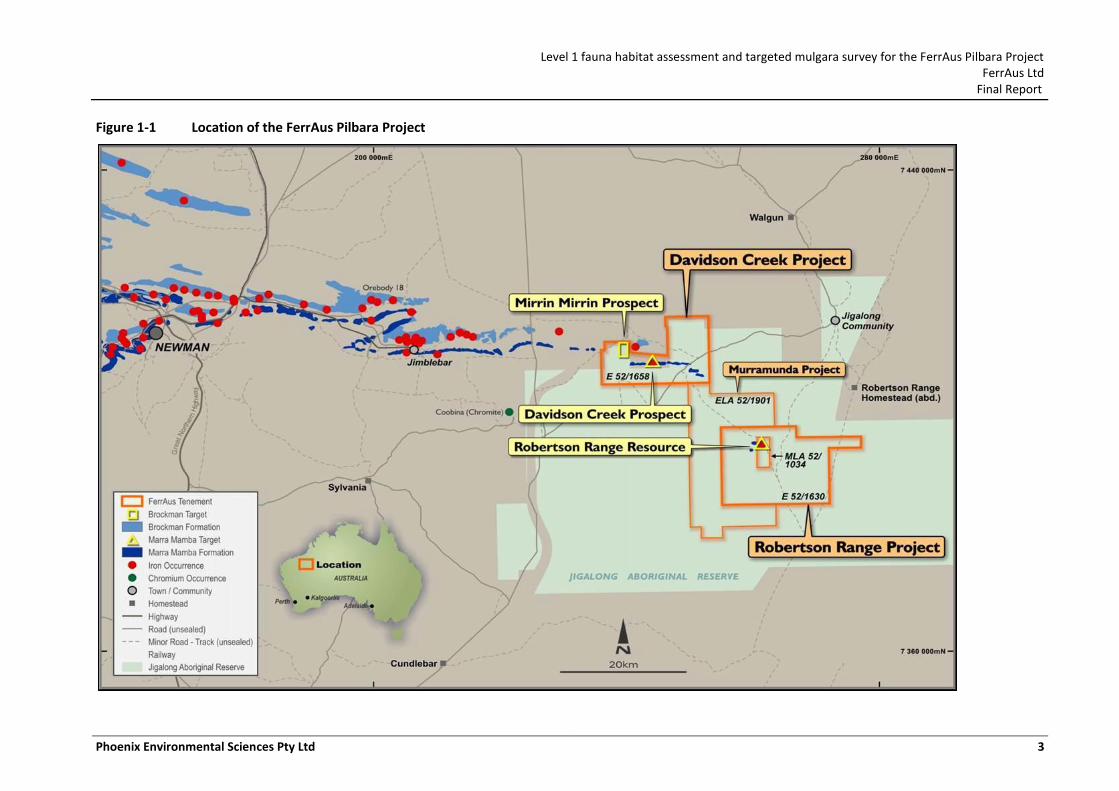
In November 2010, FerrAus Ltd commissioned Phoenix Environmental Sciences Pty Ltd (Phoenix) to undertake further surveys as part of the environmental impact assessment of the FerrAus Pilbara Project (the Project), located approximately 100 km southeast of Newman (Figure 1-1).
The following surveys were conducted:
Level 1 fauna habitat assessment for vertebrate and short-range endemic invertebrate (SRE) fauna
targeted survey for the Crest-tailed Mulgara, Dasycercus cristicauda.
This report documents the results of both surveys (completed in March 2011).
1.1 BACKGROUND
1.1.1 Level 1 fauna habitat assessment
Under the Project, FerrAus proposes to develop an iron ore mine that will include open cut pits, crushing and screening plants, and a residue storage facility with associated mine infrastructure. The crushed ore will be transported via rail to port infrastructure for loading onto ships for export.
In 2010, the Mirrin Mirrin and Dugite/Tiger deposits were defined as economically viable and added to the existing Project scope. A new location for the proposed accommodation village and a proposed airstrip were also added. No biological baseline surveys have been carried out specifically for these new components; however, a number of previous desktop reviews and baseline surveys have been undertaken for other components of the Project (see Section 2.5.7). Given the extent of previous fauna surveys undertaken to date for the Project, it was considered that a Level 1 field reconnaissance assessment of the new deposits and infrastructure developments would be sufficient to fill in the knowledge gaps for these areas in relation to fauna.
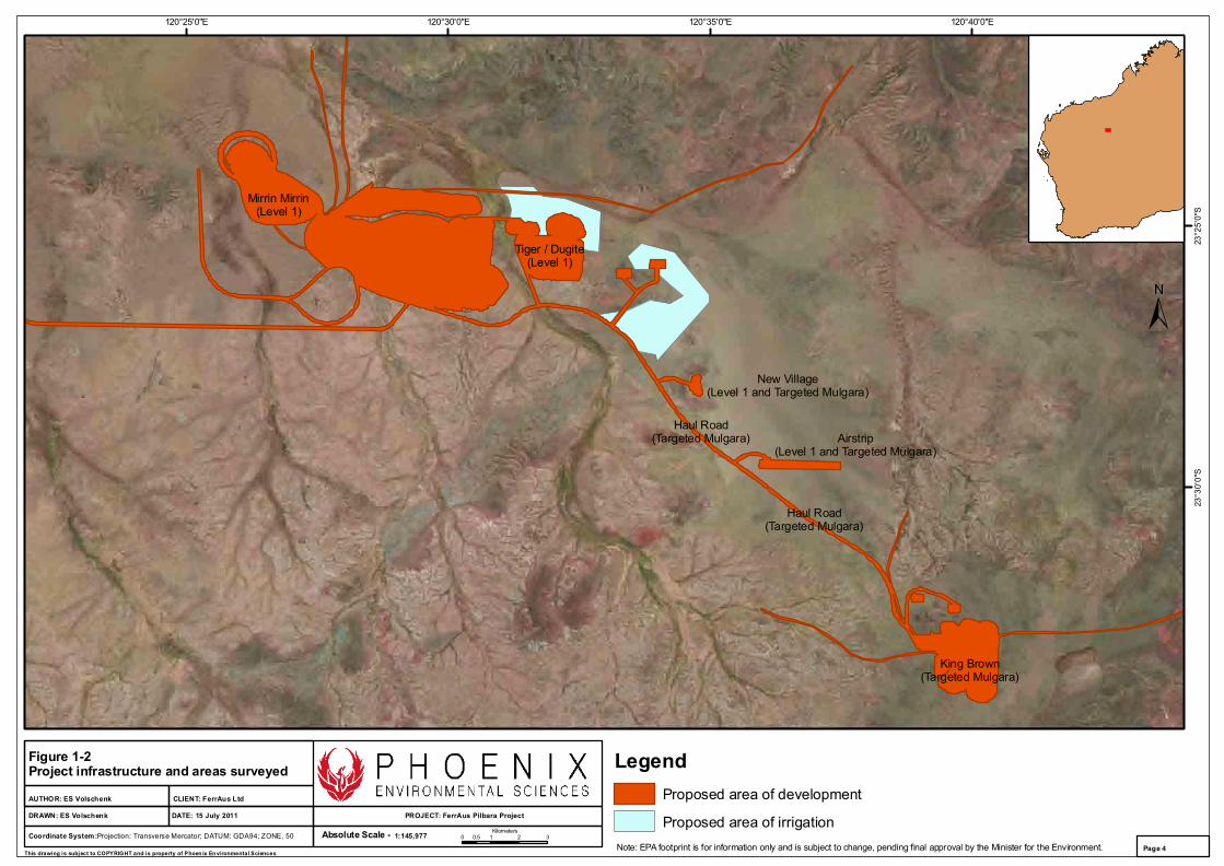
Within the Project boundaries, the following specific areas were surveyed (Figure 1-2):
Mirrin Mirrin deposit
Dugite/Tiger deposit
proposed airstrip infrastructure area
proposed village infrastructure area.
1.1.2 Crest-tailed Mulgara (Dasycercus cristicauda)
The Crest-tailed Mulgara is listed by the Western Australian Wildlife Conservation Act 1950 as a Schedule 1 species (fauna that is that is rare or is likely to become extinct). It is also listed as Vulnerable under the Commonwealth Environment Protection and Biodiversity Conservation Act 1999 (EPBC Act).
The need for a targeted Crest-tailed Mulgara survey arose from the findings of previous surveys. During Level 2 baseline vertebrate fauna surveys in September 2010, three Crest-tailed Mulgara were trapped alongside the existing access track between the Python/Gwardar and King Brown deposits (Phoenix 2010a). This track is proposed to be upgraded for use as a haul road, which will potentially impact the population in this area. A survey was required to determine the population location and size within this area.
Mulgara burrows were also recorded in previous surveys in the vicinity of the King Brown deposit (Ecologia 2007b, 2008). These were reported as potentially belonging to Crest-tailed Mulgara
Level 1 fauna habitat assessment and targeted mulgara survey for the FerrAus Pilbara Project FerrAus Ltd
Final Report
Phoenix Environmental Sciences Pty Ltd 2
(Ecologia 2007b) and Brush-tailed Mulgara (Dasycercus blythi, Priority 4; (Ecologia 2008). No animals were captured to confirm the species present in either survey. The recent capture of the more conservation-significant Crest-tailed Mulgara indicates either the burrows were incorrectly identified, or that both species exist within the Project area. Therefore, a survey was required to determine which species inhabits the King Brown deposit.
Within the Project boundaries, the following specific areas were surveyed (Figure 1-2):
King Brown deposit (M52/1034, formerly known as Robertson Range)
Haul road and services corridor to the King Brown deposit in M52/1034 (the services corridor)
proposed airstrip infrastructure area
proposed village infrastructure area.
These areas, and those included in the Level 1 assessment, are collectively referred to in this report as ‘the study area’.
1.2 SCOPE OF WORK AND SURVEY OBJECTIVES
The primary objective of the fauna assessment was to collect sufficient baseline information to accurately assess the likely environmental impact of the proposed developments on terrestrial vertebrate and SRE fauna, in a local and regional context.
The scope of the Level 1 fauna habitat assessment was as follows:
Conduct a Level 1 field reconnaissance assessment of the Mirrin Mirrin and Dugite/Tiger deposits, and the proposed airstrip and new accommodation village, where any habitats likely to be suitable for conservation significant fauna were recorded, including vertebrate and short-range endemic fauna
Prepare a technical report on the results of the assessment, identifying potential impacts of the proposed developments on conservation significant species, and providing recommendations to avoid impacts.
The scope of the targeted Crest-tailed Mulgara survey was to:
Conduct a targeted survey for the Crest-tailed Mulgara in suitable habitat along the proposed haul road between the Python/Gwardar and King Brown deposits, and within the King Brown infrastructure area
Determine population location and size within the study area
Undertake habitat mapping for the species within the study area
Prepare a technical report on the results of the survey, identifying potential impacts of the proposed developments on the target species, and providing recommendations to avoid impacts.
Where practicable, the survey design, methodology and report-writing aspects of the work adhered to appropriate principles and guidelines, including:
Environmental Protection Authority (EPA) Position Statement No. 3: Terrestrial Biological Surveys as an Element of Biodiversity Protection (EPA 2002)
EPA Guidance Statement No. 56: Terrestrial Fauna Surveys for Environmental Impact Assessment in Western Australia (EPA 2004)
EPA & Department of Environment and Conservation Technical Guide - Terrestrial Vertebrate Fauna Surveys for Environmental Impact Assessment (EPA & DEC 2010)
The limitations of the survey with respect to Guidance Statement 56 (EPA 2004) are discussed in Section 4.6.
Level 1 fauna habitat assessment and targeted mulgara survey for the FerrAus Pilbara Project FerrAus Ltd
Final Report
Phoenix Environmental Sciences Pty Ltd 3
Figure 1-1 Location of the FerrAus Pilbara Project
120°40'0"E120°35'0"E120°30'0"E120°25'0"E
23°2
5'0"
S23
°30'
0"S
Coordinate System:Projection: Transverse Mercator; DATUM: GDA94; ZONE, 50 1:145,977Absolute Scale -
CLIENT: FerrAus Ltd
PROJECT: FerrAus Pilbara ProjectDATE: 15 July 2011DRAWN: ES Volschenk
AUTHOR: ES Volschenk
Figure 1-2Project infrastructure and areas surveyed
0 1 2 30.5Kilometers
This drawing is subject to COPYRIGHT and is property of Phoen ix Environmental SciencesPage 4
Mirrin Mirrin(Level 1)
Tiger / Dugite(Level 1)
Airstrip(Level 1 and Targeted Mulgara)
New Village(Level 1 and Targeted Mulgara)
King Brown(Targeted Mulgara)
Haul Road(Targeted Mulgara)
LegendProposed area of development
Proposed area of irrigationNote: EPA footprint is for information only and is subject to change, pending final approval by the Minister for the Environment.
Haul Road(Targeted Mulgara)
Level 1 fauna habitat assessment and targeted mulgara survey for the FerrAus Pilbara Project FerrAus Ltd
Final Report
Phoenix Environmental Sciences Pty Ltd 5
2 EXISTING ENVIRONMENT
2.1 INTERIM BIOGEOGRAPHIC REGIONALISATION OF AUSTRALIA (IBRA) REGION
The Interim Biogeographic Regionalisation of Australia (IBRA) defines ‘bioregion’ as large land areas characterised by broad, landscape-scale natural features and environmental processes that influence the functions of entire ecosystems (DSEWPC 2011b). Their purpose is to capture the large-scale geophysical patterns that occur across the Australian continent. The identified patterns in the landscape are linked to fauna and flora assemblages and processes at the ecosystem scale. They are a useful means for simplifying and reporting on more complex patterns of biodiversity (Thackway & Cresswell 1995b).
Western Australia contains 26 IBRA bioregions and 53 subregions. By combining the IBRA regions with information on protected areas, the level of protection of Australia's various landscapes can be measured. IBRA is therefore a dynamic tool for monitoring progress towards building a comprehensive, adequate and representative reserve system (DSEWPC 2011b).
The study area is situated in the Augustus subregion (GAS3) of the Gascoyne bioregion. However, it also lies close to the junction of the Little Sandy Desert bioregion and Fortescue Plains subregion (PIL2) of the Pilbara bioregion (Thackway & Cresswell 1995b), and therefore contains elements of each. The majority of the study area most closely resembles the Pilbara bioregion in terms of fauna and flora assemblages, but there are fauna species present that are more representative of the Gascoyne bioregion.
The Augustus subregion is characterised by rugged, low, Proterozoic sedimentary and granite ranges, divided by broad flat valleys, and contains the headwaters of the Ashburton and Fortescue Rivers (Thackway & Cresswell 1995b). There are areas of alluvial valley-fill deposits, characteristic of this subregion, in the study area. Mulga woodland over Spinifex occurs predominantly on shallow stony loams on rises, while the shallow earthy loams over hardpan on the plains are covered by Mulga parkland (Desmond et al. 2001).
The Fortescue Plains subregion is characterised by alluvial plains, river frontages, extensive salt marsh, mulga-bunch grass, and short grass communities on alluvial plains in the east. River Gum woodlands fringe the drainage lines, and the region represents the northern limit of Mulga (Acacia aneura; (Thackway & Cresswell 1995b).
The Hamersley subregion (PIL3) is a mountainous area of Proterozoic sedimentary ranges and plateaux, which are dissected by gorges in basalt, shale and dolerite. Mulga low woodland occurs over bunch grasses on fine textured soils in the valley floors. Eucalyptus leucophloeia over Triodia brizoides is found on the skeletal soils of the ranges (Thackway & Cresswell 1995b).
The Little Sandy Desert bioregion is an area of low rainfall, characterised by Quaternary dunefields and Proterozoic ranges of the Bangemall Basin. Soils consist of red sands associated with dunefields (the closest of which are situated approximately 20km to the south-east of the study area) and plains (common in the study area). Alluvial plains within this subregion support river gum communities and bunch grassland (Thackway & Cresswell 1995a), of which several examples are present within the study area.
2.2 LAND SYSTEMS
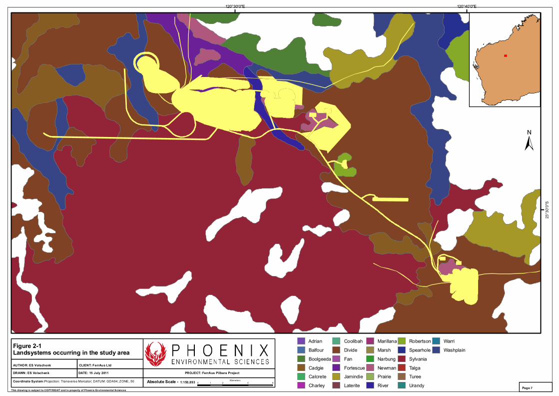
The Department of Agriculture and Food WA (Van Vreeswyk et al. 2004) has mapped the land systems of the region from aerial photography, providing the largest-scale interpretation of vegetation units for the study area. The study area traverses the following six land systems:
Level 1 fauna habitat assessment and targeted mulgara survey for the FerrAus Pilbara Project FerrAus Ltd
Final Report
Phoenix Environmental Sciences Pty Ltd 6
Cadgie – Hardpan plains with thin sand cover and sandy banks supporting Mulga shrublands with soft and hard spinifex
Divide – Sandplains and occasional dunes supporting shrubby hard spinifex grasslands
Newman – Rugged jaspilite plateaux, ridges and mountains supporting hard spinifex grasslands
River - Active flood plains and major rivers supporting grassy eucalypt woodlands, tussock grasslands and soft spinifex grasslands
Robertson - Hills and ranges of sedimentary rocks supporting hard spinifex grasslands
Sylvania – Gritty surfaced plains and low rises on granite supporting acacia-Eremophila-Cassia shrublands
Washplain – Hardpan plains supporting grooved Mulga shrublands.
The study area lies primarily within the Divide land system. The haul road and services corridor mainly crosses the Divide land system, but also briefly passes through the Cadgie, Robertson, and Newman land systems. The northern section passes through the Sylvania land system, briefly crossing the River and Cadgie land systems.
The Dugite/Tiger deposit lies within the Divide, Newman and River land systems. The Mirrin Mirrin deposit predominantly crosses the Divide land system, but also crosses the Washplain land system. The King Brown deposit is primarily situated within the Divide land system, but also crosses a small area of the Newman land system.
The proposed new accommodation village lies almost completely within the Robertson land system. The proposed airstrip lies completely within the Divide land system.
2.3 CLIMATE OF THE STUDY AREA AND WEATHER DURING SURVEY PERIOD
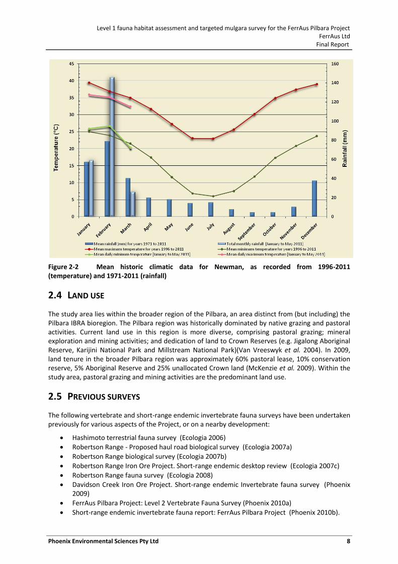
The study area has a desert climate with summer rain, representing one of two bioclimatic regions of the broader Pilbara region (McKenzie et al. 2009; Van Vreeswyk et al. 2004). Rainfall is highly variable but is more prevalent in summer. The average rainfall over the broader Pilbara region is about 290 mm, ranging from a monthly average of approximately 2 mm in September to 66 mm in February. Rainfall patterns are driven by highly variable year-to-year cyclonic activity that accounts for half of the yearly precipitation (McKenzie et al. 2009).
One of the nearest Bureau of Meteorology (BOM) weather stations is located at Newman Airport (no. 7176; 23.42°S 119.80°E, alt. 524 m) approximately 110 km south of the study area. Newman Airport has its highest mean maximum monthly temperature (39.5°C) in January and the lowest mean maximum temperature (23.0°C) in July (Figure 2-2) (BOM 2011). The highest mean minimum temperature is recorded for January (25.0°C) and the lowest mean minimum temperature for July (6.0°C). The area has an average annual rainfall of 310 mm January and February are the wettest months and overall (Figure 2-2). Average annual (pan) evaporation in the area is approximately 3600 mm per year (Department of Agriculture 2003), which greatly exceeds annual rainfall and consequently contributes to the arid environment.
The survey was completed between 12 and 18 March 2011. Average temperatures and rainfall were lower than the historical means recorded for this month (Figure 2-2). Exceptionally high rainfall was recorded across the Pilbara and Gascoyne regions in February 2011 as a result of frequent thunderstorm activity, two tropical cyclones and a tropical low, with some localities receiving their highest rainfalls on record (BOM 2011). Higher-than-average rainfall (145.8 mm) occurred at Newman Airport during February, being nearly twice the long-term February average (Figure 2-2).
120°40'0"E120°30'0"E
23°3
0'0"
S
Coordinate System:Projection: Transverse Mercator; DATUM: GDA94; ZONE, 50 1:150,893Absolute Scale -
CLIENT: FerrAus Ltd
PROJECT: FerrAus Pilbara ProjectDATE: 15 July 2011DRAWN: ES Volschenk
AUTHOR: ES Volschenk
Figure 2-1Landsystems occurring in the study area
0 2 4 61Kilometers
This drawing is subject to COPYRIGHT and is property of Phoen ix Environmental SciencesPage 7
Adrian
Balfour
Boolgeeda
Cadgie
Calcrete
Charley
Coolibah
Divide
Fan
Fortescue
Jamindie
Laterite
Marillana
Marsh
Narbung
Newman
Prairie
River
Robertson
Spearhole
Sylvania
Talga
Turee
Urandy
Warri
Washplain
Level 1 fauna habitat assessment and targeted mulgara survey for the FerrAus Pilbara Project FerrAus Ltd
Final Report
Phoenix Environmental Sciences Pty Ltd 8
Figure 2-2 Mean historic climatic data for Newman, as recorded from 1996-2011 (temperature) and 1971-2011 (rainfall)
2.4 LAND USE
The study area lies within the broader region of the Pilbara, an area distinct from (but including) the Pilbara IBRA bioregion. The Pilbara region was historically dominated by native grazing and pastoral activities. Current land use in this region is more diverse, comprising pastoral grazing; mineral exploration and mining activities; and dedication of land to Crown Reserves (e.g. Jigalong Aboriginal Reserve, Karijini National Park and Millstream National Park)(Van Vreeswyk et al. 2004). In 2009, land tenure in the broader Pilbara region was approximately 60% pastoral lease, 10% conservation reserve, 5% Aboriginal Reserve and 25% unallocated Crown land (McKenzie et al. 2009). Within the study area, pastoral grazing and mining activities are the predominant land use.
2.5 PREVIOUS SURVEYS
The following vertebrate and short-range endemic invertebrate fauna surveys have been undertaken previously for various aspects of the Project, or on a nearby development:
Hashimoto terrestrial fauna survey (Ecologia 2006)
Robertson Range - Proposed haul road biological survey (Ecologia 2007a)
Robertson Range biological survey (Ecologia 2007b)
Robertson Range Iron Ore Project. Short-range endemic desktop review (Ecologia 2007c)
Robertson Range fauna survey (Ecologia 2008)
Davidson Creek Iron Ore Project. Short-range endemic Invertebrate fauna survey (Phoenix 2009)
FerrAus Pilbara Project: Level 2 Vertebrate Fauna Survey (Phoenix 2010a)
Short-range endemic invertebrate fauna report: FerrAus Pilbara Project (Phoenix 2010b).
Level 1 fauna habitat assessment and targeted mulgara survey for the FerrAus Pilbara Project FerrAus Ltd
Final Report
Phoenix Environmental Sciences Pty Ltd 9
2.6 RELEVANT LEGISLATION AND AGREEMENTS
International
Migratory species are protected under a number of international agreements:
Japan-Australia Migratory Bird Agreement (JAMBA)
China-Australia Migratory Bird Agreement (CAMBA)
Convention on the Conservation of Migratory Species of Wild Animals (Bonn)
Agreement between the Government of Australia and the Government of the Republic of Korea on the Protection of Migratory Birds (ROKAMBA).
Commonwealth
Under the Environment Protection and Biodiversity Conservation Act 1999 (EPBC Act), actions that have, or are likely to have, a significant impact on a matter of national environmental significance (NES) require approval from the Australian Government Minister for the Environment, Water, Heritage and the Arts (the Minister). The EPBC Act provides for the listing of nationally threatened native species. Fauna species of national conservation significance may be classified as ‘critically endangered’, ‘endangered’, ‘vulnerable’ or ‘conservation dependent’.
The EPBC Act is also the enabling legislation for protection of migratory species under the international agreements listed above.
State
Native species in Western Australia which are under identifiable threat of extinction are protected under the Western Australian Wildlife Conservation Act 1950 (WC Act). Under the WC Act, the Wildlife Conservation (Specially Protected Fauna) Notice 2008 (2) recognises four classifications of rare and endangered fauna:
Schedule 1: Fauna that is rare or is likely to become extinct
Schedule 2: Fauna presumed to be extinct
Schedule 3: Birds protected under an international agreement
Schedule 4: Other specially protected fauna.
In addition, the DEC produces a list of Priority species (last update: August 2010) that have not been assigned statutory protection under the WC Act. Species on this list are considered to be of conservation priority because there is insufficient information to make an assessment of their conservation status or they are considered to be rare but not threatened and are in need of monitoring. The DEC Priority Fauna List categories are:
Priority 1: Taxa with few, poorly known populations on threatened lands
Priority 2: Taxa with few, poorly known populations on conservation lands
Priority 3: Taxa with several, poorly known populations, some on conservation lands
Priority 4: Taxa in need of monitoring – considered not currently threatened but could be if present circumstances change
Priority 5: Taxa in need of monitoring – considered not currently threatened but subject to a conservation program, the cessation of which could result in the species becoming threatened.
Level 1 fauna habitat assessment and targeted mulgara survey for the FerrAus Pilbara Project FerrAus Ltd
Final Report
Phoenix Environmental Sciences Pty Ltd 10
3 CREST-TAILED MULGARA LIFE HISTORY AND ECOLOGY
3.1 GENERAL BIOLOGY AND IDENTIFICATION
The Crest-tailed Mulgara, Dasycercus cristicauda, is a small, primarily nocturnal, dasyurid marsupial found only in Australia’s arid zone. The body fur is tan to ginger above and on the tail, and creamy white on the underbelly (Masters 2008). Its most distinctive feature is a crest of black hairs at the end of the tail. Other features distinguishing it from the closely related Brush-tailed Mulgara (D. blythi) are a third premolar tooth in one or both upper jaws, eight nipples in the pouch, and long hair folding over a third of the foot-sole from the outer side only (Masters 2008; Woolley 2005). However, others have noted that the third premolar is not a consistent trait (R. How, 2011, pers. comm. 24 March; C. Pavey, 2011, pers. comm. 6 April).
Size varies between the sexes. Males range from 130–230 mm in body length, and weigh 110–185 g. Females range from 120–170 mm in body length, and weigh 65–120 g (Masters 2008).
3.2 TAXONOMY AND NOMENCLATURE
The Dasycercus genus has recently undergone a taxonomic revision. The taxonomy and nomenclature referred to in this report follows Woolley (2005). For many years classified only under Dasycercus cristicauda, the two morphologically and genetically distinct species of Dasycercus have now been separated: Brush-tailed Mulgara (D. blythi) and Crest-tailed Mulgara (D. cristicauda). A third species, D. hillieri, is considered synonymous with D. cristicauda, and no longer exists as a separate species (Masters 2008; Woolley 2005). Dasycercus cristicauda is listed as Vulnerable under the EPBC Act; however, D. hillieri is listed as Endangered. The new Survey Guidelines for Australia’s Threatened Mammals (DSEWPC 2011c) addresses the listings under the EPBC Act. Under these guidelines, D. hillieri is considered to be a form of D. cristicauda found only in the Eastern Simpson Desert (Queensland, Northern Territory and South Australia), although this is not supported by taxonomic studies (Woolley 2005). Dasycercus blythi has been grouped with D. cristicauda, implying that both species are now considered Vulnerable under the EPBC Act (DSEWPC 2011c).
Due to the reclassification of the Dasycercus genus, published information on Crest-tailed Mulgara is likely to relate to the more widespread Brush-tailed Mulgara in many cases, for example the work of P. Masters at Uluru – Kata Tjuta National Park, as confirmed by (Körtner et al. 2007). Considering the difficulty in determining which species is referred to in the literature, the following information on life history traits refers to both Mulgara species unless otherwise specified.
3.3 HABITAT AND DISTRIBUTION
While some work has been completed to define which species are referred to in the various records and literature (Körtner et al. 2007; Woolley 2005, 2006), there is still confusion when dealing with older material referring to the genus. In particular, distribution information is likely to refer to both species, and this makes it difficult to determine exact habitat requirements.
The current distribution map listed for the Crest-tailed Mulgara under the EPBC Act shows a wide distribution, covering most of central Australia and spreading into north-western Western Australia (DSEWPC 2011a). It is likely that both species have been included in this map, as the EPBC Act has not clearly distinguished between the two species since the taxonomic revision (DSEWPC 2011c). The distribution map provided for the Crest-tailed Mulgara in Masters (2008) shows a very restricted central Australian location, while noting older records have come from Western Australia on the Canning Stock Route and Nullarbor Plain. However, more recent surveys are expanding the known range of Crest-tailed Mulgara (Phoenix 2010a; Thompson & Thompson 2007). Mulgara have now
Level 1 fauna habitat assessment and targeted mulgara survey for the FerrAus Pilbara Project FerrAus Ltd
Final Report
Phoenix Environmental Sciences Pty Ltd 11
been recorded in Western Australia in the Great Victoria Desert, Goldfields, Gascoyne, Sandy Desert and Pilbara regions (DEC 2011).
It is likely that the range of both Dasycercus species overlaps, as noted from historic specimen records (Masters 2008; Woolley 2008c, 2005). These historic records also point to potential differences in habitat preference, e.g. Crest-tailed Mulgara found on top of sandhills and Brush-tailed Mulgara on the Spinifex plains. Likewise, Masters (2008) notes that Crest-tailed Mulgara are found on sand dunes with a sparse cover of Sandhill Canegrass or areas around salt lakes with Nitre bush, and Brush-tailed Mulgara are found on Spinifex grasslands with medium to dense cover. However, recent surveys show that Crest-tailed Mulgara are also found on medium to dense Spinifex plains (Phoenix 2010a; Thompson & Thompson 2007).
No studies on the use of habitat by Crest-tailed Mulgara have been completed. Brush-tailed Mulgara do not show a preference for the amount of cover present in the area, rather they utilise a habitat mosaic between patches of mature Spinifex and shrubs to open areas, even after severe fires (Körtner et al. 2007). Individual differences are evident in use of habitat, some animals preferring more open areas to others. Likewise, Masters et al. (2003) showed that reduction of cover did not significantly affect abundance or food resources; however, alternative cover was present in this study and may have affected the results, further indicating the use and importance of a habitat mosaic.
Thompson and Thompson (2007) found that Crest-tailed Mulgara continued to use an area after severe fires removed much of the vegetation. Körtner et al. (2007) noted that Brush-tailed Mulgara that had home ranges largely in open habitat were more susceptible to predation than those in areas with more cover, implying that inappropriate management of fire may impact Mulgara abundance through increased predation risk from cats and foxes.
Mulgara burrows are generally found under dense Spinifex hummocks or in open sand away from vegetation, but they also occur under Canegrass clumps, Nitre Bush hummocks, and small shrubs including melaleuca and grevillea (Körtner et al. 2007; Masters 2003; Thompson & Thompson 2007). Burrows are often originally constructed by another animal, including goannas and other lizards, rodents and rabbits, or are later converted to use by these animals (Körtner et al. 2007; Masters 2003; Thompson & Thompson 2007). Thompson and Thompson (2007) noted that Crest-tailed Mulgara shared their burrows with other animals, including goannas, lizards, and other small mammals. Mulgara of both species will share burrows with animals of either sex, especially during the breeding season (Körtner et al. 2007; Masters 2003; Thompson & Thompson 2007).
Mulgara burrows are generally complexes consisting of two to nine entrances (Körtner et al. 2007; Masters 2003; Thompson & Thompson 2007), although Körtner et al. (2007) also reported a number of single entrance burrows. There is some indication that Crest-tailed Mulgara produce burrow complexes with more entrance holes than Brush-tailed Mulgara (Körtner et al. 2007; Thompson & Thompson 2007; Woolley 1990).
The tunnels rarely lead more than 30 cm below ground (Körtner et al. 2007; Thompson & Thompson 2007), although Woolley (1990) recorded tunnels at depths of 50 cm and one metre. Within the burrow complex, there is always one grass-lined nest chamber (Körtner et al. 2007; Masters 2003; Thompson & Thompson 2007).
3.4 DIET
Mulgara are carnivorous. Chen et al. (1998) found that Mulgara in the Simpson Desert, Queensland, ate a high proportion of insects, followed by arachnids and rodents. Smaller numbers of reptiles, centipedes, and small marsupials were also eaten. Prey choice varied through the year, with more prey items added at different times of the year. The majority of the autumn diet consisted of insects.
Level 1 fauna habitat assessment and targeted mulgara survey for the FerrAus Pilbara Project FerrAus Ltd
Final Report
Phoenix Environmental Sciences Pty Ltd 12
More rodents were eaten in winter and spring than in autumn, and more reptiles during spring compared to the rest of the year.
There was no significant difference between the prey items taken by males and females. However, females greatly increased their vertebrate intake from winter to spring, whereas males increased their vertebrate intake from autumn to winter.
3.5 HOME RANGE SIZE
Home range studies have only been completed on Brush-tailed Mulgara in the Tanami Desert and Uluru Kata Tjuta National Park. Masters (2003) recorded an average male home range of 7.3 and 8.1 ha at two sites, with individual home ranges extending from 1 to 14.4 ha. In comparison, females averaged 4.7 and 5.8 ha at the two sites, with individual home ranges between 1.4 and 12.2 ha. There was no significant difference in home range size between the sexes, or between the two sites. However, Körtner et al. (2007) did report significant differences between male and female home ranges. Average male home range was 25.5 ha, compared to 10.8 ha for females. Home ranges overlapped substantially between neighbouring animals, whether of the same or different sex, during the breeding season (Körtner et al. 2007; Masters 2003).
Male home ranges are larger during the mating season. Masters (2003) found that the average male home range during the mating season was 9.9 ha, compared to 5.6 ha during the rest of the year. Kortner et al. (2007) reported that male home ranges averaged 25.5 ha, but noted this may have been due to tracking during the mating season or after a fire had potentially reduced available resources. Likewise, a female radio-tracked through the breeding season had a home range of 4 to 5 ha, which then expanded to 12 ha after the juveniles were independent (Masters 2003).
The variation in seasonal home ranges demonstrated in Brush-tailed Mulgara may be assumed to also occur in Crest-tailed Mulgara. It is important to note that any distribution information recorded during a single survey may not reflect the full extent and use of the area throughout the year.
Brush-tailed Mulgara are noted as having a sedentary lifestyle, meaning that they maintain a stable home range and may live in one location for many years (Körtner et al. 2007; Masters 2003). This has important implications within the framework of environmental impact assessment, as disturbance within known Mulgara habitat has the potential to dramatically affect the entire population at that location.
3.6 BREEDING BIOLOGY
The exact breeding biology of the Crest-tailed Mulgara is unknown, due to the lack of studies. Most information relates to Brush-tailed Mulgara, and few wild studies have been completed. It is assumed that the breeding biology of the two species is very similar (Masters 2008).
Brush-tailed Mulgara mate from April to June (Masters 2003; Woolley 2008c). Gestation lasts five to six weeks, with the young being born from June to September (Woolley 2008c). Pouch young are weaned at three to four months (mid-spring to early summer), and become sexually mature at 10 to 11 months (Dickman et al. 2001; Woolley 2008c). Only a single litter is born each year (Dickman et al. 2001). Captive animals have lived as long as six years, and were reproductively active each year (Woolley 2008c).
Captive Crest-tailed Mulgara, while not actually breeding, showed a similar pattern of annual reproductive activity. Sperm production in males took place between early April and late June. Females came into oestrus in late April to early May, and maximal pouch development occurred in late June to early July (Woolley 2006). Crest-tailed Mulgara have eight nipples in the pouch and up to eight juveniles can be born (Masters 2008; Woolley 2005).
Level 1 fauna habitat assessment and targeted mulgara survey for the FerrAus Pilbara Project FerrAus Ltd
Final Report
Phoenix Environmental Sciences Pty Ltd 13
Mulgara abundance can be influenced by rainfall. High rainfalls in summer have lead to increased capture rates of Brush-tailed Mulgara seven to nine months later (Dickman et al. 2001). Rodent populations also increased approximately six months after heavy rainfall, therefore Mulgara population increases could be linked to increased vertebrate prey availability (Dickman et al. 2001). Letnic and Dickman (2005) also found increased captures of Mulgara after heavy rainfall caused by the La Niña phase of the El Niño Southern Oscillation. However, Masters (1993) did not find a correlation between Mulgara abundance and rainfall events, and Woolley (1990) found that Mulgara numbers decreased after above average rainfall, possibly due to vertebrate prey dying in floods.
3.7 THREATENING PROCESSES
The specific processes threatening both species of Mulgara are not precisely known. Most likely, disturbance and destruction of habitat due to grazing, altered fire regimes, introduced herbivores and predators are affecting distribution and population size (Maxwell et al. 1996; Woolley 2008a, b). Körtner et al. (2007) reported that decreased cover after severe fire may have led to increased predation of Brush-tailed Mulgara by cats and foxes.
Level 1 fauna habitat assessment and targeted mulgara survey for the FerrAus Pilbara Project FerrAus Ltd
Final Report
Phoenix Environmental Sciences Pty Ltd 14
4 METHODS
4.1 CONSULTATION
The scope of works were discussed with Mr Dillip Henderson (SKM Consulting), Mr Brett Hazelden and Mr Peter Brookes (FerrAus Ltd) and Mr Jarrad Clark (Phoenix) on 26 November 2010.
Tissue samples to enable genetic analysis and biological measurements from each captured Crest-tailed Mulgara were requested by Dr Stephen van Leeuwen (7 March 2011), and were subsequently undertaken.
All work was completed under DEC Licence to Take Fauna for Scientific Purposes number SF007763, according to Regulation 17 of the WC Act.
4.2 HABITAT ASSESSMENT AND SITE SELECTION
4.2.1 Level 1 fauna habitat assessments
Level 1 field reconnaissance surveys were conducted at the following locations:
Mirrin Mirrin deposit (3 sites)
Dugite/Tiger deposit (5 sites)
Proposed airstrip infrastructure area (2 sites)
Proposed village infrastructure area (6 sites).
At each location, several survey sites were selected for assessment based on the habitats present. At the broadest scale, site selection considered aspect, topography and land systems. At the finer scale, consideration was given to proximity to water bodies (drainage lines and creeks), vegetation condition and soil type (where known). Sites were primarily chosen:
to represent the best example of a distinct habitat within the broader habitat associations of the particular deposit or infrastructure location
when considered the best choice to inform the assessment process.
All survey sites were characterised using a range of vegetative, geological and landscape attributes (Appendix 1). Each site was also photographed and its location recorded (WGS84 - UTMS; Appendix 1). Locations of all fauna habitat assessment sites are presented in Figure 4-1.
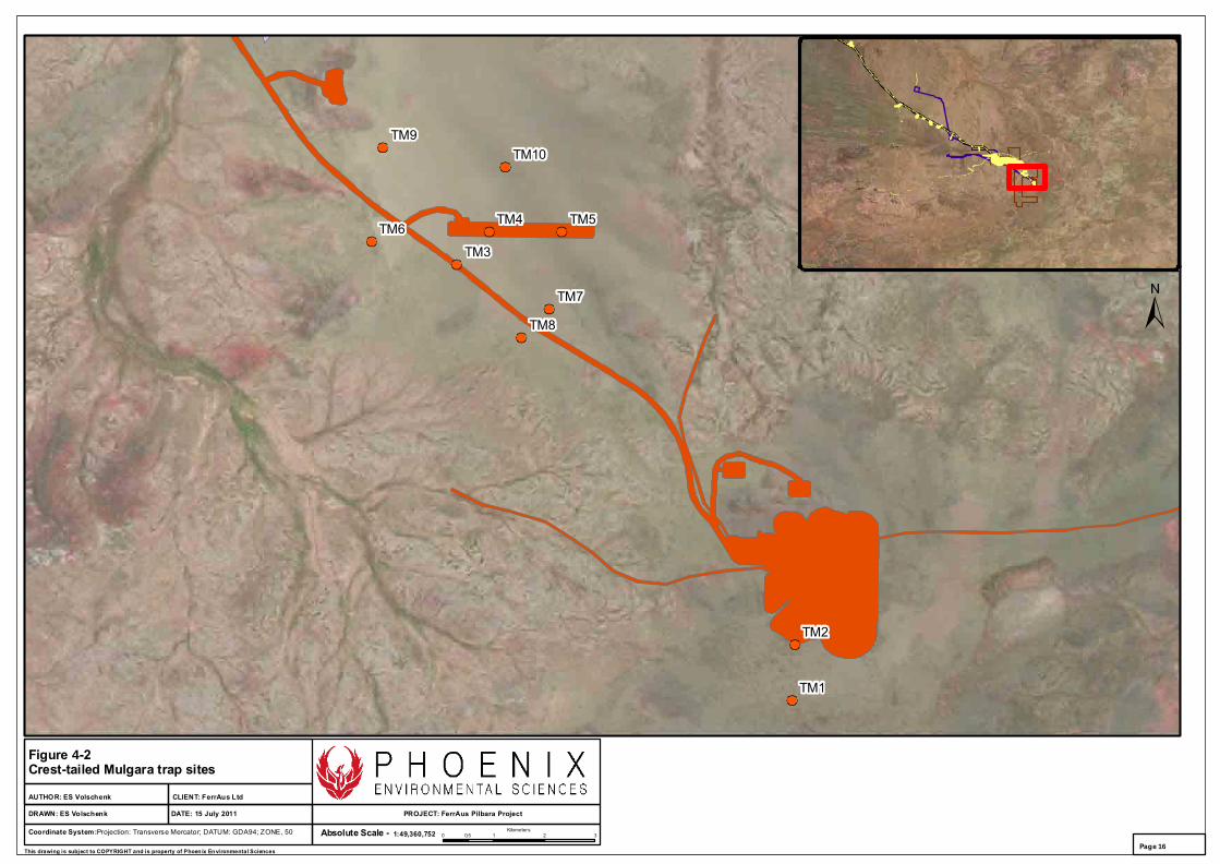
4.2.2 Targeted Crest-tailed Mulgara survey
Prior to the field survey, vegetation mapping data, aerial photography and previous survey reports were reviewed in order to define potential Crest-tailed Mulgara habitat within the study area, and to pre-select trapping sites.
Ten systematic trapping sites were selected, predominantly consisting of dense Spinifex sandplain with varying amounts of shrub and tree cover. Eight sites were located within a corridor 6 km long and 3 km wide along the proposed haul road. This included a site at either end of the proposed airstrip. Two trapping sites were also located within the King Brown deposit area.
All survey sites were characterised using a range of vegetative, geological and landscape attributes (Appendix 2). Each site was also photographed and its location recorded (WGS84 - UTMS; Appendix 2). Locations of all systematic trapping sites are presented in Figure 4-2.

Village 6Village 5
Village 4Village 3
Village 2Village 1
Airstrip 2Airstrip 1
Dugite/Tiger 5Dugite/Tiger 4
Dugite/Tiger 3Dugite/Tiger 1
Mirrin Mirrin 3
Mirrin Mirrin 2
Mirrin Mirrin 1
Coordinate System:Projection: Transverse Mercator; DATUM: GDA94; ZONE, 50 1:49,360,752Absolute Scale -
CLIENT: FerrAus Ltd
PROJECT: FerrAus Pilbara ProjectDATE: 15 July 2011DRAWN: ES Volschenk
AUTHOR: ES Volschenk
Figure 4-1 Level 1 fauna assessment sites
0 0.7 1.4 2.10.35Kilometers
This drawing is subject to COPYRIGHT and is property of Phoen ix Environmental SciencesPage 15
TM9
TM8
TM7
TM6TM5TM4
TM3
TM2
TM1
TM10
Coordinate System:Projection: Transverse Mercator; DATUM: GDA94; ZONE, 50 1:49,360,752Absolute Scale -
CLIENT: FerrAus Ltd
PROJECT: FerrAus Pilbara ProjectDATE: 15 July 2011DRAWN: ES Volschenk
AUTHOR: ES Volschenk
Figure 4-2Crest-tailed Mulgara trap sites
0 1 2 30.5Kilometers
This drawing is subject to COPYRIGHT and is property of Phoen ix Environmental SciencesPage 16
Level 1 fauna habitat assessment and targeted mulgara survey for the FerrAus Pilbara Project FerrAus Ltd
Final Report
Phoenix Environmental Sciences Pty Ltd 17
4.3 SURVEY METHODS
4.3.1 Level 1 fauna habitat assessments
Each of the 16 survey sites was assessed for habitat significance, and visually searched for evidence of conservation significant and other species. This included recording sightings, calls, tracks, scats, and other signs. Active searching (e.g. under logs, litter and bark) was completed at each site. This particularly targeted reptiles and small mammals. Bird surveys (20 minutes duration) were also completed.
Each site was also visually assessed with regard to the site’s ability to drive short-range endemism within the invertebrate fauna. A number of biological features lead to short-range endemism, and these formed the basis of the habitat assessment, whereby habitat characteristics considered likely to support or promote short-range endemism were actively investigated. Specifically, the following habitats and habitat characteristics were considered:
woodlands
ridgetops
south-facing slopes that support denser vegetation communities
gullies and gorges
rock and boulder piles
wetland and drainage basin communities
areas of dense leaf litter and debris (sticks and logs) accumulation, including in drifts or under trees and in gorges
isolated examples of each of the above.
No active searches for SRE fauna were undertaken as the scope of the survey was for a habitat assessment only. Accordingly, no invertebrate specimens were collected.
4.3.2 Targeted Crest-tailed Mulgara survey
4.3.2.1 Trapping survey
Ten systematic trapping sites were established within the study area (Figure 4-2). Each trapping site consisted of a 5x5 trapping grid of 25 small Elliott box traps (8 cm x 9 cm x 23 cm) placed at 25 m intervals. Each grid therefore covered an area of one hectare (100 x 100 m). To prevent heat stress, traps were placed inside a shade made from reflective insulation material (R2 rated), and then positioned under vegetation.
Traps were checked each morning within three hours after sunrise, and were immediately closed. All traps were re-opened in the late afternoon (between 3.30pm and 6pm). Universal bait consisting of rolled oats, peanut butter and sardines was used to bait the traps. Traps were re-baited every two days, or daily if ants were a problem. Where there was a high ant presence, baits were removed during morning trap checks and traps were rebaited in the afternoon.
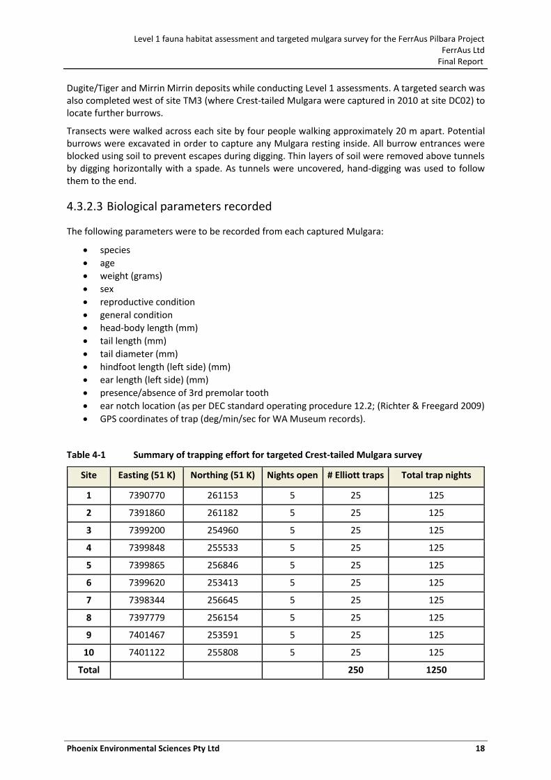
Trapping occurred over five consecutive nights at each site. The total trapping effort for the survey period was 1,250 trap nights, where one trap-night is defined as one trap remaining open for one night (Table 4-1).
4.3.2.2 Burrow searches
Any Mulgara burrows found at the trapping sites were recorded. Searches for burrows were conducted across the proposed airstrip, proposed new village, and also within the proposed
Level 1 fauna habitat assessment and targeted mulgara survey for the FerrAus Pilbara Project FerrAus Ltd
Final Report
Phoenix Environmental Sciences Pty Ltd 18
Dugite/Tiger and Mirrin Mirrin deposits while conducting Level 1 assessments. A targeted search was also completed west of site TM3 (where Crest-tailed Mulgara were captured in 2010 at site DC02) to locate further burrows.
Transects were walked across each site by four people walking approximately 20 m apart. Potential burrows were excavated in order to capture any Mulgara resting inside. All burrow entrances were blocked using soil to prevent escapes during digging. Thin layers of soil were removed above tunnels by digging horizontally with a spade. As tunnels were uncovered, hand-digging was used to follow them to the end.
4.3.2.3 Biological parameters recorded
The following parameters were to be recorded from each captured Mulgara:
species
age
weight (grams)
sex
reproductive condition
general condition
head-body length (mm)
tail length (mm)
tail diameter (mm)
hindfoot length (left side) (mm)
ear length (left side) (mm)
presence/absence of 3rd premolar tooth
ear notch location (as per DEC standard operating procedure 12.2; (Richter & Freegard 2009)
GPS coordinates of trap (deg/min/sec for WA Museum records).
Table 4-1 Summary of trapping effort for targeted Crest-tailed Mulgara survey
Site Easting (51 K) Northing (51 K) Nights open # Elliott traps Total trap nights
1 7390770 261153 5 25 125
2 7391860 261182 5 25 125
3 7399200 254960 5 25 125
4 7399848 255533 5 25 125
5 7399865 256846 5 25 125
6 7399620 253413 5 25 125
7 7398344 256645 5 25 125
8 7397779 256154 5 25 125
9 7401467 253591 5 25 125
10 7401122 255808 5 25 125
Total 250 1250
Level 1 fauna habitat assessment and targeted mulgara survey for the FerrAus Pilbara Project FerrAus Ltd
Final Report
Phoenix Environmental Sciences Pty Ltd 19
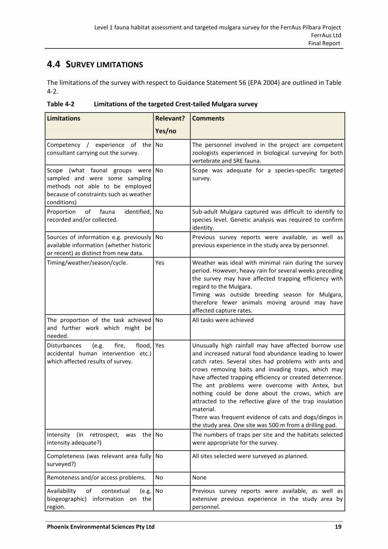
4.4 SURVEY LIMITATIONS
The limitations of the survey with respect to Guidance Statement 56 (EPA 2004) are outlined in Table 4-2.
Table 4-2 Limitations of the targeted Crest-tailed Mulgara survey
Limitations Relevant?
Yes/no
Comments
Competency / experience of the consultant carrying out the survey.
No The personnel involved in the project are competent zoologists experienced in biological surveying for both vertebrate and SRE fauna.
Scope (what faunal groups were sampled and were some sampling methods not able to be employed because of constraints such as weather conditions)
No Scope was adequate for a species-specific targeted survey.
Proportion of fauna identified, recorded and/or collected.
No Sub-adult Mulgara captured was difficult to identify to species level. Genetic analysis was required to confirm identity.
Sources of information e.g. previously available information (whether historic or recent) as distinct from new data.
No Previous survey reports were available, as well as previous experience in the study area by personnel.
Timing/weather/season/cycle. Yes Weather was ideal with minimal rain during the survey period. However, heavy rain for several weeks preceding the survey may have affected trapping efficiency with regard to the Mulgara. Timing was outside breeding season for Mulgara, therefore fewer animals moving around may have affected capture rates.
The proportion of the task achieved and further work which might be needed.
No All tasks were achieved
Disturbances (e.g. fire, flood, accidental human intervention etc.) which affected results of survey.
Yes Unusually high rainfall may have affected burrow use and increased natural food abundance leading to lower catch rates. Several sites had problems with ants and crows removing baits and invading traps, which may have affected trapping efficiency or created deterrence. The ant problems were overcome with Antex, but nothing could be done about the crows, which are attracted to the reflective glare of the trap insulation material. There was frequent evidence of cats and dogs/dingos in the study area. One site was 500 m from a drilling pad.
Intensity (in retrospect, was the intensity adequate?)
No The numbers of traps per site and the habitats selected were appropriate for the survey.
Completeness (was relevant area fully surveyed?)
No All sites selected were surveyed as planned.
Remoteness and/or access problems. No None
Availability of contextual (e.g. biogeographic) information on the region.
No Previous survey reports were available, as well as extensive previous experience in the study area by personnel.
Level 1 fauna habitat assessment and targeted mulgara survey for the FerrAus Pilbara Project FerrAus Ltd
Final Report
Phoenix Environmental Sciences Pty Ltd 20
4.5 SURVEY PERSONNEL AND ACKNOWLEDGEMENTS
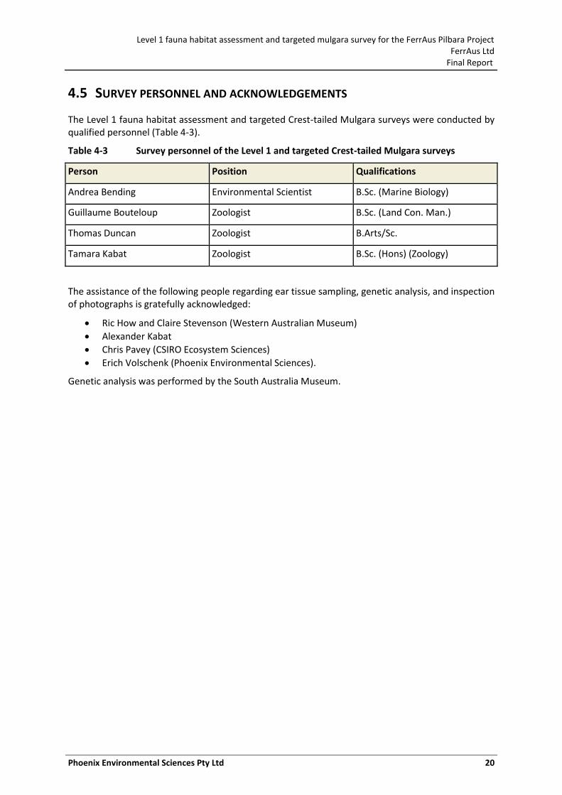
The Level 1 fauna habitat assessment and targeted Crest-tailed Mulgara surveys were conducted by qualified personnel (Table 4-3).
Table 4-3 Survey personnel of the Level 1 and targeted Crest-tailed Mulgara surveys
Person Position Qualifications
Andrea Bending Environmental Scientist B.Sc. (Marine Biology)
Guillaume Bouteloup Zoologist B.Sc. (Land Con. Man.)
Thomas Duncan Zoologist B.Arts/Sc.
Tamara Kabat Zoologist B.Sc. (Hons) (Zoology)
The assistance of the following people regarding ear tissue sampling, genetic analysis, and inspection of photographs is gratefully acknowledged:
Ric How and Claire Stevenson (Western Australian Museum)
Alexander Kabat
Chris Pavey (CSIRO Ecosystem Sciences)
Erich Volschenk (Phoenix Environmental Sciences).
Genetic analysis was performed by the South Australia Museum.
Level 1 fauna habitat assessment and targeted mulgara survey for the FerrAus Pilbara Project FerrAus Ltd
Final Report
Phoenix Environmental Sciences Pty Ltd 21
5 RESULTS
5.1 LEVEL 1 FAUNA HABITAT ASSESSMENTS
5.1.1 Fauna habitats of the study area
The following four broad habitats of importance to vertebrate fauna have been identified across the study area:
• Spinifex sandplain • Mulga woodland • Major creeklines and floodplains • Low rocky ranges and rocky slopes.
These are consistent with the habitat types occurring across the larger Project area, that is, no new habitat types were recorded. The Mulga woodlands, and to a lesser extent the creeklines, also provide potential habitat for SRE fauna.
1. Spinifex sandplain
Spinifex sandplains form the dominant habitat type across the study area. This habitat was particularly noted at sites Village 1, Village 4, Airstrip 1, Airstrip 2, Mirrin Mirrin 2, Dugite/Tiger 1, and Dugite/Tiger 3.
The habitat consists of sandy plains vegetated with hummock grassland (predominantly Spinifex) and scattered trees and shrubs. The sandy substrate provides ideal habitat for burrowing reptiles and mammals, especially combined with the cover provided by Spinifex hummocks. Patches of low shrubs provide habitat for small birds, and small ground-dwelling birds utilise the Spinifex hummocks. Larger trees provide nesting habitat and shelter for birds and reptiles in the open landscape.
Spinifex plains rarely give rise to short-range endemism as they tend to contain few elements that can hold water in the landscape (i.e. large logs and deep litter accumulations) and are typically very large habitats that link the more mesic and restricted habitats, such as found within ridgelines, drainage basins and riparian zones.
2. Mulga woodland
Mulga woodlands form a major habitat in the study area. This habitat was particularly noted at sites Mirrin Mirrin 1, Mirrin Mirrin 3, and Dugite/Tiger 2. The ridgetop site at Village 6 also had dense Mulga stands.
These open to moderately dense woodlands occur on sandy plains and rocky slopes. The understorey can be composed of tussock or hummock grasses. The woodlands provide nesting and habitat and shelter for birds and reptiles. Tussocks and hummocks provide habitat for small birds, reptiles and mammals.
Within the habitats investigated as part of the Level 1 assessment, Mulga woodlands have the greatest chance to harbour SRE fauna. The relatively dense vegetation cover and resultant deep litter and debris accumulations provide shelter for a range of potential SRE faunal groups such as small snails, trap-door spiders, scorpions, isopods and millipedes. Mulga woodlands also tend to be isolated and probably act as inter-period (geological or climatic) stepping stones or distribution points for SRE fauna as vegetation contracts and expands. This scenario is yet to be tested in the Pilbara, although it has been noted with respect to the vertebrate fauna that Mulga woodlands harbour a unique assemblage and are under threat from altered burning regimes (McKenzie et al. 2009). The scorpion Urodacus ‘Davidson Creek’ could potentially occur in this habitat.
Level 1 fauna habitat assessment and targeted mulgara survey for the FerrAus Pilbara Project FerrAus Ltd
Final Report
Phoenix Environmental Sciences Pty Ltd 22
3. Creeklines and floodplains
Creekline and floodplain habitats were only recorded at the Dugite/Tiger deposit. This habitat was recorded at sites Dugite/Tiger 4 and Dugite/Tiger 5.
Vegetation is generally open Eucalyptus/Corymbia or Acacia woodland over shrubs and tussock grasses. The creek beds and surrounding soils consist of coarse gravels through to sand. The riparian woodlands provide nesting, habitat and shelter for birds and reptiles. Burrowing reptiles and mammals are likely to utilise sandy substrates and fine gravels for burrows. Tussock grasses and low shrubs provide habitat for small birds, reptiles and mammals.
Creeklines typically display a denser and more structurally complex vegetation community that gives rise the formation of leaf litter and debris accumulations that have the potential to harbour SRE fauna. Creeklines typically link habitats and landscape features and are therefore not isolated, but may harbour SRE taxa. The maintenance of the vegetation structure, and the underlying groundwater hydrology, is important for SRE taxa in creekline habitats. The scorpion Urodacus ‘Davidson Creek’ could potentially occur in this habitat.
4. Low rocky range and rocky slopes
The location of the proposed accommodation village contains a small rocky ridge and associated rocky slopes. This habitat was recorded at sites Village 2, Village 3, Village 5, and Village 6.
Vegetation in these areas generally comprises sparse Mulga and eucalypt trees, and small tree stands. The understorey consists of Spinifex hummock grasslands and shrubs. More open areas consist of open shrublands of Grevillea and Acacia over hummock grassland. The ground surface varies from sand to clay and rocky substrates.
Rock cracks, boulders, crevices, small caves and overhangs provide shelter for a wide variety of reptiles and mammals. Suitable habitat for nesting birds-of-prey is limited and no caves large enough for bat roosts were identified. Large trees and dense tree stands provide nesting habitat and shelter for birds and reptiles. Rocky scree slopes provide suitable habitat for the Western Pebble-mound Mouse.
Low rocky ridges and slopes typically do not support SRE fauna. Vegetation cover and structure in this habitat type is typically low and therefore leaf litter and debris accumulation also remains low. Species from groups known to contain SREs are often present in this habitat type, but are generally found to be widespread. The exception is where these habitats occur as extensive south facing slopes that are typically sheltered, allowing woodlands and other mesic assemblages to develop. Such ‘sub-habitats’ are more common on the larger ridgelines of the Hamersley and Chichester Ranges and are not present in the study area.
5.1.2 Conservation significant fauna of the study area
5.1.2.1 Summary
A desktop review was completed for the Level 2 vertebrate fauna survey of the Python/Gwardar deposit, King Brown deposit, haul road and services corridor, process and rail load out infrastructure, former proposed village, communication tower, expanded Python/Gwardar waste dump, and creek diversion. These searches identified 17 species of conservation significance potentially occurring in the area (Phoenix 2010a).
The area examined in the desktop review closely corresponds to the current study area. However, a number of these species are considered unlikely to occur given the habitats present within the study area. The likelihood of occurrence of each of these species is addressed in Table 6-1.
Level 1 fauna habitat assessment and targeted mulgara survey for the FerrAus Pilbara Project FerrAus Ltd
Final Report
Phoenix Environmental Sciences Pty Ltd 23
Two species of conservation significance were directly recorded during the field reconnaissance survey: Australian Bustard (Ardeotis australis), and Rainbow Bee-eater (Merops ornatus). A Bush Stone-curlew (Burhinus grallarius) was also heard calling at the current accommodation village. Habitat for these three species was recorded across the study area. The locations of records for these three species are shown in Figure 5-1 and Appendix 3.
Potential habitat was also recorded for the Western Pebble-mound Mouse (Pseudomys chapmani), Crest-tailed Mulgara (Dasycercus cristicauda) and Brush-tailed Mulgara (Dasycercus blythi). A further five species may potentially use the study area (Table 5-1).
Potential impacts of the proposed developments on all species of conservation significance are addressed in Section 6.2 and Table 6-1.
5.1.2.2 Ardeotis australis (Australian Bustard)
Status: Priority 4 (DEC Priority Fauna List)
Distribution and ecology: The Australian Bustard is a large, ground-dwelling bird that favours open or lightly wooded grasslands, chenopod flats and plains, and heathlands and farming country (Johnstone & Storr 1998). Found across Australia, it is nomadic and highly mobile, and may range over large areas locally. Local abundance may vary from scarce to common depending on season and food supply (Johnstone & Storr 1998). Key threats to the species include habitat alteration and loss, predation by Cats, Foxes and Dingoes, livestock grazing, hunting and invasion of habitats by woody weeds.
Records and likely distribution within the study area: The Australian Bustard has been recorded across the larger Project area in a range of habitats, including sandy Spinifex plains and low rocky ranges, and is relatively common (Phoenix 2011a). Tracks were recorded at sites Village 2, Village 4, Village 6, Dugite/Tiger 4, and Dugite/Tiger 5. Potential habitat was also recorded at the proposed airstrip and the Mirrin Mirrin deposit. The habitat across much of the study area and its surrounds is suitable for Australian Bustard, and its nomadic behaviour would make its occurrence in any one particular area likely.
5.1.2.3 Merops ornatus (Rainbow Bee-eater)
Status: Migratory (EPBC Act)
Distribution and ecology: The Rainbow Bee-eater is a migratory bird that moves between Australia and Asia. It can be found across Australia, with complex seasonal movements depending on location and rainfall, preferring the more watered areas of the country. In Western Australia, the Rainbow Bee-eater can be found in lightly wooded, preferably sandy, country near water. Occurring as a resident, breeding visitor, postnuptial nomad, passage migrant or winter visitor, and being highly mobile, they can be scarce to common locally. They are often associated with creek lines supporting sandy banks in which burrows can be created (Johnstone & Storr 1998).
Records and likely distribution within the study area: The Rainbow Bee-eater has been recorded across the larger Project area in a variety of habitats including creeklines, ridges, and open woodland (Phoenix 2011a). Rainbow Bee-eaters were observed at sites Village 1, Village 2, and Village 4. Potential habitat was also recorded at the Mirrin Mirrin and Dugite/Tiger deposits.
5.1.2.4 Burhinus grallarius (Bush Stone-curlew)
Status: Priority 4 (DEC Priority Fauna List)
Distribution and ecology: The Bush Stone-curlew is a relatively large, ground-dwelling bird that prefers lightly wooded country near daytime shelter such as thickets or long grass. It can be found
Level 1 fauna habitat assessment and targeted mulgara survey for the FerrAus Pilbara Project FerrAus Ltd
Final Report
Phoenix Environmental Sciences Pty Ltd 24
across much of Australia except the arid interior and southern coast. In Western Australia, the species is considered to be uncommon to common in the northern subhumid and semiarid zones, and rare to uncommon and locally extinct further south (Johnstone & Storr 1998). The species is considered sedentary (stable home range and non-migratory; (Garnett & Crowley 2000). The Bush Stone-curlew is a ground-dwelling species and therefore susceptible to predation and local disturbance by humans. Their numbers tend to decline around human settlements.
Records and likely distribution within the study area: A Bush Stone-curlew was heard calling at current accommodation village during the survey period. While this lies outside the study area, it is an important record for the overall Project area. Only one other record exists for the larger Project area (Phoenix 2011a). Potential habitat was recorded at the proposed accommodation village and the Dugite/Tiger deposit.
5.1.2.5 Dasycercus cristicauda (Crest-tailed Mulgara) and Dasycercus blythi (Brush-tailed Mulgara)
Status: Crest-tailed Mulgara - Schedule 1 (DEC Threatened Fauna List); Vulnerable (EPBC Act)
Brush-tailed Mulgara - Priority 4 (DEC Priority Fauna List)
Distribution and ecology: Full details on the life history and ecology of the two Mulgara species is provided in Section 3.
Records and likely distribution within the study area: Records and potential distribution for the Crest-tailed Mulgara across the larger Project area are discussed in detail in Sections 5.2 and 5.3. The Brush-tailed Mulgara has not yet been captured, but may potentially occur in the study area.
No records were made during the field reconnaissance survey; however, captures of Crest-tailed Mulgara have been made close to the proposed airstrip (Sections 5.2 and 5.3). The Spinifex plain habitats across much of the study area are suitable for both species, due to the depth of sand and the maturity of the hummock grasslands present. Spinifex plains are found across the proposed airstrip, accommodation village (outside hill areas), and the deposits at Mirrin Mirrin and Tiger/Dugite.
5.1.2.6 Pseudomys chapmani (Western Pebble-mound Mouse)
Status: Priority 4 (DEC Priority Fauna List)
Distribution and ecology: The Western Pebble-mound Mouse is widespread in the ranges of the central and southern Pilbara and extends into the Little Sandy Desert Ranges (Van Dyck & Strahan 2008). Originally classified as a Priority 1 species, recent survey records have found the species is widespread, and it has been downgraded to Priority 4.
These mice construct large mounds from small pebbles. Colonies of up to 25 mice may live inside a mound. Pebble size averages 3.5 grams, and the mounds may cover 0.5– 9.0 m2. The mounds are located on the gentle slopes of rocky ranges covered in rocky mulch, hard Spinifex and sparse trees and shrubs (Eucalyptus, Senna, Acacia and Ptilotus). They are also often found near Acacia-dominated drainage lines (Van Dyck & Strahan 2008). Threats to the Western Pebble-mound Mouse are not well known but feral Cat predation may be a key cause of the species’ decline.
Records and likely distribution within the study area:
No records were made during the field reconnaissance survey. Habitat with low potential for Western Pebble-mound Mouse was found in the vicinity of the proposed accommodation village. Several records of old and inactive mounds have been made in the larger Project area (Phoenix 2011a), therefore they may potentially occur in the study area.
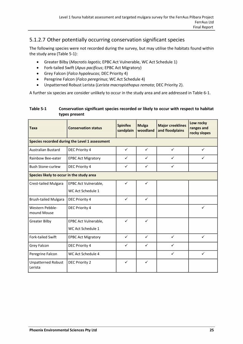
Level 1 fauna habitat assessment and targeted mulgara survey for the FerrAus Pilbara Project FerrAus Ltd
Final Report
Phoenix Environmental Sciences Pty Ltd 25
5.1.2.7 Other potentially occurring conservation significant species
The following species were not recorded during the survey, but may utilise the habitats found within the study area (Table 5-1):
Greater Bilby (Macrotis lagotis; EPBC Act Vulnerable, WC Act Schedule 1)
Fork-tailed Swift (Apus pacificus; EPBC Act Migratory)
Grey Falcon (Falco hypoleucos; DEC Priority 4)
Peregrine Falcon (Falco peregrinus; WC Act Schedule 4)
Unpatterned Robust Lerista (Lerista macropisthopus remota; DEC Priority 2).
A further six species are consider unlikely to occur in the study area and are addressed in Table 6-1.
Table 5-1 Conservation significant species recorded or likely to occur with respect to habitat types present
Taxa Conservation status Spinifex sandplain
Mulga woodland
Major creeklines and floodplains
Low rocky ranges and rocky slopes
Species recorded during the Level 1 assessment
Australian Bustard DEC Priority 4
Rainbow Bee-eater EPBC Act Migratory
Bush Stone-curlew DEC Priority 4
Species likely to occur in the study area
Crest-tailed Mulgara EPBC Act Vulnerable,
WC Act Schedule 1
Brush-tailed Mulgara DEC Priority 4
Western Pebble-mound Mouse
DEC Priority 4
Greater Bilby EPBC Act Vulnerable,
WC Act Schedule 1
Fork-tailed Swift EPBC Act Migratory
Grey Falcon DEC Priority 4
Peregrine Falcon WC Act Schedule 4
Unpatterned Robust Lerista
DEC Priority 2
Village 6Village 5
Village 4Village 3
Village 2Village 1
Airstrip 2Airstrip 1
Dugite/Tiger 5Dugite/Tiger 2
Dugite/Tiger 1
Mirrin Mirrin 3
Mirrin Mirrin 2
Mirrin Mirrin 1
Coordinate System:Projection: Transverse Mercator; DATUM: GDA94; ZONE, 50 1:49,360,752Absolute Scale -
CLIENT: FerrAus Ltd
PROJECT: FerrAus Pilbara ProjectDATE: 15 July 2011DRAWN: ES Volschenk
AUTHOR: ES Volschenk
Figure 5-1 Conservation significant species recorded in the study area
0 0.7 1.4 2.10.35Kilometers
This drawing is subject to COPYRIGHT and is property of Phoen ix Environmental SciencesPage 26
Australian Bustard, Tracks
Bush Stone-Curlew, Direct sighting
Rainbow Bee-eater, Direct sighting
Proposed area of development
Proposed area of irrigation
Level 1 fauna habitat assessment and targeted mulgara survey for the FerrAus Pilbara Project FerrAus Ltd
Final Report
Phoenix Environmental Sciences Pty Ltd 27
5.2 TARGETED CREST-TAILED MULGARA SURVEY
5.2.1 Survey results
5.2.1.1 Trapping results
Trapping success was very low, which is typical of targeted Mulgara surveys (Thompson & Thompson 2010). Five species were recorded, including the target species, the Crest-tailed Mulgara (Dasycercus cristicauda), Spinifex Hopping Mouse (Notomys alexis; 2 captures), Little Button-quail (Turnix velox; 6 captures), and two lizard species, Ctenotus hanloni and C. uber (1 capture each) (Appendix 4).
Only one Crest-tailed Mulgara was captured during the survey. The animal was a sub-adult female, and exhibited characteristics of both Mulgara species. The tail was long and thin, with a red base and small crest-like brush at the end, suggesting a Crest-tailed Mulgara. However, the tail was not strongly crested, and the absence of a third premolar tooth on either side of the upper jaw suggested it was a Brush-tailed Mulgara. Western Australian Museum (Ric How) and CSIRO (Chris Pavey) experts were consulted regarding photos taken of the animal (Figure 5-2, Figure 5-3 and Figure 5-4), but neither could provide a definite determination. An ear tissue sample taken was therefore analysed by the South Australia Museum and this method conclusively confirmed the animal as Crest-tailed Mulgara.
Locations of all Crest-tailed Mulgara captures are shown in Figure 5-5 and Table 5-2. The most recent capture occurred approximately 1.5 km north-west of the Crest-tailed Mulgara captures made in September 2010 (Phoenix 2010a).
Figure 5-2 Crest-tailed Mulgara captured during the targeted survey in February 2011
Level 1 fauna habitat assessment and targeted mulgara survey for the FerrAus Pilbara Project FerrAus Ltd
Final Report
Phoenix Environmental Sciences Pty Ltd 28
Figure 5-3 Crest-tailed Mulgara captured during targeted survey in February 2011
Figure 5-4 Tail of the Crest-tailed Mulgara captured during targeted survey in February 2011
(note the tail is not distinctly brush-like or crest-like)
5.2.1.2 Burrow records
Only six potential burrows were located across the study area in the current survey. A burrow was found at site TM3 during the Level 2 survey (site DC02) in September 2010, and was located again during the targeted survey. As three Crest-tailed Mulgara were captured at this site during the
Level 1 fauna habitat assessment and targeted mulgara survey for the FerrAus Pilbara Project FerrAus Ltd
Final Report
Phoenix Environmental Sciences Pty Ltd 29
September 2010 survey, destructive sampling was not used to investigate the burrow for potential occupants.
Potential burrows were found at sites TM1 and TM6 during the trapping survey. Targeted searches located potential burrows near site TM3, near site TM4 within the proposed airstrip location, and at the Dugite/Tiger deposit. All potential burrows were dug out. Only the burrow at TM1 at the King Brown deposit conformed to a typical Mulgara burrow shape and it was found to be inactive, i.e. no nesting material was found within the burrow and there was no sign of recent active use.
Seven mulgara burrows recorded during previous surveys in the vicinity of the King Brown deposit, and were reported both as Crest-tailed Mulgara (Ecologia 2007b) and Brush-tailed Mulgara (Ecologia 2008). However, no animals were captured to confirm the species present in either survey. In light of recent survey results, it is assumed that these burrows belong to Crest-tailed Mulgara, although the Brush-tailed Mulgara could potentially also be found here.
Locations of all known Crest-tailed Mulgara burrows in the study area are shown in Figure 5-5 and Table 5-2.
5.3 LOCAL DISTRIBUTION OF CREST-TAILED MULGARA
A single Crest-tailed Mulgara was captured during the targeted survey, approximately 600 m from the existing access track between the Python/Gwardar and King Brown deposits. Three Crest-tailed Mulgara were captured within 100 m of the access track during the Level 2 vertebrate fauna assessment in September 2010. Burrows found at this location and further south at the King Brown deposit indicate a large area of probable distribution, possibly representing at least two separate populations. The lack of captures during the targeted survey prevented an analysis of population size and movements across the study area.
The known distribution of Crest-tailed Mulgara in the study area, based on captured animals, therefore lies west of the current access track. This area is bordered to the north-west by ‘Halfway Hill’, and by low hill ranges to the west and south (Robertson Range) (Figure 5-5).
Inactive burrows located within and surrounding the King Brown deposit present a known distribution in this area, although recent activity has not been noted here and no animals have been captured (Figure 5-5).
Recent surveys have covered a wide area surrounding the proposed mining and infrastructure developments in the south-west of the overall Project area (‘extent of surveyed areas’, Figure 5-5). The habitat across much of this area is suitable for Crest-tailed Mulgara, being mature Spinifex plains on deep sandy clay loams. This includes the sites surveyed during the Level 1 fauna habitat assessment, i.e. proposed airstrip, proposed new village (outside hill areas), and the deposits at Mirrin Mirrin and Dugite/Tiger.
The potential habitat for Crest-tailed Mulgara (and potentially co-occurring Brush-tailed Mulgara) within the extent of the recently surveyed areas has been defined (Figure 5-5). This map covers only the areas that have been visited during previous surveys; therefore, it is based on knowledge of the study area and also habitat that could be confidently identified by aerial mapping. However, not all of the areas mapped as potential habitat have been ground-truthed. This map does not cover areas outside recent survey boundaries, and potential habitat (based on aerial maps) is likely to be found beyond the extent of the surveyed areas. Of particular note is the area west-south-west of the survey extent, which is likely to contain habitat for Crest-tailed Mulgara. Any developments in this area would require additional surveying to determine the presence of Crest-tailed Mulgara.
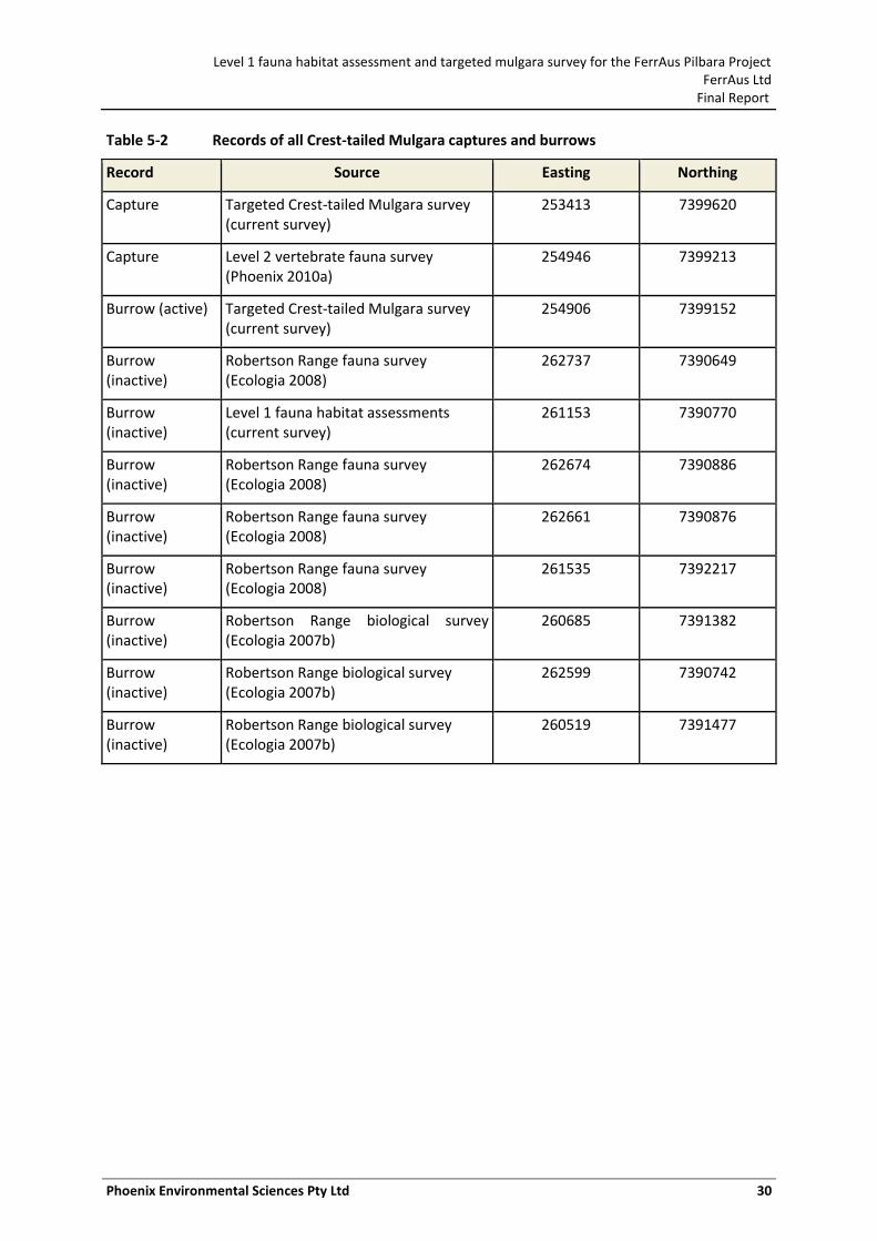
Level 1 fauna habitat assessment and targeted mulgara survey for the FerrAus Pilbara Project FerrAus Ltd
Final Report
Phoenix Environmental Sciences Pty Ltd 30
Table 5-2 Records of all Crest-tailed Mulgara captures and burrows
Record Source Easting Northing
Capture Targeted Crest-tailed Mulgara survey (current survey)
253413 7399620
Capture Level 2 vertebrate fauna survey (Phoenix 2010a)
254946 7399213
Burrow (active) Targeted Crest-tailed Mulgara survey (current survey)
254906 7399152
Burrow (inactive)
Robertson Range fauna survey (Ecologia 2008)
262737 7390649
Burrow (inactive)
Level 1 fauna habitat assessments (current survey)
261153 7390770
Burrow (inactive)
Robertson Range fauna survey (Ecologia 2008)
262674 7390886
Burrow (inactive)
Robertson Range fauna survey (Ecologia 2008)
262661 7390876
Burrow (inactive)
Robertson Range fauna survey (Ecologia 2008)
261535 7392217
Burrow (inactive)
Robertson Range biological survey (Ecologia 2007b)
260685 7391382
Burrow (inactive)
Robertson Range biological survey (Ecologia 2007b)
262599 7390742
Burrow (inactive)
Robertson Range biological survey (Ecologia 2007b)
260519 7391477
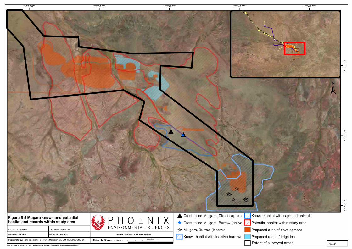
120°45'0"E120°40'0"E120°35'0"E120°30'0"E120°25'0"E
23°2
5'0"
S23
°30'
0"S
23°3
5'0"
S
Coordinate System:Projection: Transverse Mercator; DATUM: GDA94; ZONE, 50 1:156,947Absolute Scale -
CLIENT: FerrAus Ltd
PROJECT: FerrAus Pilbara ProjectDATE:15 June 2011DRAWN: TJ Kabat
AUTHOR: TJ Kabat
Figure 5-5 Mugara known and potential habitat and records within study area
0 2 4 61Kilometers
This drawing is subject to COPYRIGHT and is property of Phoen ix Environmental SciencesPage 31
Crest-tailed Mulgara, Direct capture
Crest-tailed Mulgara, Burrow (active)
Mulgara, Burrow (inactive)
Known habitat with inactive burrows
Known habitat with captured animals
Potential habitat within study area
Proposed area of development
Proposed area of irrigation
Extent of surveyed areas
Level 1 fauna habitat assessment and targeted mulgara survey for the FerrAus Pilbara Project FerrAus Ltd
Final Report
Phoenix Environmental Sciences Pty Ltd 32
6 DISCUSSION
6.1 FAUNA VALUES OF THE STUDY AREA
Four broad habitat types for vertebrate fauna were identified across the study area:
• Spinifex sandplain • Mulga woodland • Major creeklines and floodplains • Low rocky ranges and rocky slopes.
Spinifex sandplains represent the largest and most important habitat in the study area, and were found at all surveyed locations. Areas of Mulga woodlands were found at the Mirrin Mirrin and Dugite/Tiger deposits, as well as stands within the rocky range at the new accommodation village. Major creeklines and floodplains were only found within the Dugite/Tiger deposit. A low rocky range and rocky slopes comprised almost all of the area surveyed for the new accommodation village.
Although each of these habitats may harbour SREs, either as a whole unit or within small areas containing the requisite structure and elements in other areas of the Pilbara, none were identified in this study.
The Level 1 field reconnaissance survey of the proposed airstrip, new accommodation village, and the deposits at Mirrin Mirrin and Dugite/Tiger recorded two species of conservation significance, the Australian Bustard and the Rainbow Bee-eater. A Bush Stone-curlew was also recorded near the current accommodation village, adding an important record to the overall Project data. Suitable habitat was identified for a further eight species.
The targeted Crest-tailed Mulgara survey yielded only one animal. High rainfall in February 2011 (almost twice the long-term February average) may have affected the trapping efficacy. The study area had experienced increased vegetation growth prior to the survey, and large numbers of insects were seen during the survey. Chen et al. (1998) reported that almost 100% of the Mulgara diet during autumn consisted of insects. The capture rate of Mulgara is also typically low, even in a known location (current survey; (Dickman et al. 2001; Thompson & Thompson 2008, 2007). Capture rates of one animal for every 200 trap nights has been reported for densely populated areas (Thompson & Thompson 2010). Further, it is also possible that local hydrological changes may have affected the use of the habitat and burrows within the study area, potentially causing the animals to move to other locations.
6.2 POTENTIAL IMPACTS AND MANAGEMENT RECOMMENDATIONS
The following impacts may affect species of conservation significance in the study area:
Proposed haul road specific impacts
Habitat loss and fragmentation
Loss of individual fauna and road mortality
Disturbance and displacement of individuals
Spread of introduced animals and weeds
Fire.
The impact assessment is focussed primarily on potential impacts to the Crest-tailed Mulgara as it is the only species of high conservation significance noted for the study area. However, the assessment is relevant to other lower ranked conservation significant species, including the Australian Bustard, Bush Stone Curlew, Rainbow Bee-eater, Western Pebble-mound Mouse and Brush-tailed Mulgara (if
Level 1 fauna habitat assessment and targeted mulgara survey for the FerrAus Pilbara Project FerrAus Ltd
Final Report
Phoenix Environmental Sciences Pty Ltd 33
present). Potential impacts of the proposed development on species of conservation significance are summarised in Table 6-1.
An assessment of how the proposed works may trigger a referral under the EPBC Act for impacts on Crest-tailed Mulgara has been provided in Table 6-2.
6.2.1 Proposed haul road specific impacts
The existing access track between the Python/Gwardar and King Brown deposits has been in constant use for over four years, increasing during the last two years (Phoenix 2010a). Three Crest-tailed Mulgara were captured within 100 m west of the access track. This population has obviously -been existing successfully alongside the current small-scale track. During the current survey, a single Crest-tailed Mulgara was captured approximately 600 m southwest of the access track. The area west of the existing access track is therefore designated as known Crest-tailed Mulgara habitat and further disturbance or clearance within this area should be avoided.
Due to the known and potential Crest-tailed Mulgara habitat existing for some distance on either side of the access track, it is recommended that the existing track be upgraded without diversion. Any diversion would potentially lead to the discovery and disturbance of other Crest-tailed Mulgara populations, and lead to unnecessary vegetation clearance.
Any widening of the existing access track should be completed on the eastern-side of the track to avoid the known Crest-tailed Mulgara population to the west. However, potential Crest-tailed Mulgara habitat exists on the east of the access track and the possibility of Crest-tailed Mulgara being found here cannot be discounted. Construction works should be combined with burrow searching and translocation procedures as described in Section 6.2.2.
During construction, signage should be erected to indicate the presence of Crest-tailed Mulgara close to the road, and vehicle access to the west of the road must be prevented.
Once completed, the haul road should have a reduced speed limit enforced within the known Crest-tailed Mulgara habitat.
Dust from construction and road use once operational as a haul road will potentially impact on the Crest-tailed Mulgara living close to the haul road. Dust can smother vegetation, eventually reducing the value of the fauna habitat, and may affect other conservation significant species utilising the area. The impact of dust can be minimised by implementing dust suppression techniques (e.g. spraying the track) during construction and on an on-going basis once the haul road is operational. Rehabilitation of associated disturbed areas should also occur as soon as is practical.
6.2.2 Habitat loss and fragmentation
Land clearing and associated habitat loss and fragmentation are the greatest threatening processes to Crest-tailed Mulgara and other conservation significant species as a result of the proposed development, unless adequate conservation management practices are implemented. Prior to any vegetation or ground clearance work commencing, an appropriate management plan for Crest-tailed Mulgara will be required to guide the course of works.
Brush-tailed Mulgara are generally sedentary, and tend to establish a stable home range without spreading into further areas (Körtner et al. 2007; Masters 2003). It can reasonably be assumed that this also applies to Crest-tailed Mulgara. Roads and tracks can present a barrier to animal movements, causing fragmentation of populations after construction. Fragmentation may have already occurred due to the construction of the existing access track between the Python/Gwardar and King Brown deposits. There is no evidence as yet that Crest-tailed Mulgara occur to the east of the access track; however, the habitat here is identical to that west of the access track and could have previously supported a population and records may yet occur.
Level 1 fauna habitat assessment and targeted mulgara survey for the FerrAus Pilbara Project FerrAus Ltd
Final Report
Phoenix Environmental Sciences Pty Ltd 34
Any works that involve ground disturbance or removal (including haul road development) within the known and potential Crest-tailed Mulgara habitat in the study area will result in the loss of any Crest-tailed Mulgara populations at that location. Translocation of populations found in these areas will therefore need to be implemented, should they be found to be present. In particular, inactive Mulgara burrows (species unconfirmed) have been found at the King Brown deposit, and any clearance work here is likely to require translocations should active burrow be found. Likewise, should construction of the proposed airstrip uncover any burrows to the east of the existing access track, translocations will be required.
Translocations will require both trapping and intensive burrow searches and excavation in order to remove all Crest-tailed Mulgara (and Brush-tailed Mulgara) in the clearance area. Both methods are required due to the relatively low trap success rates (current survey; (Thompson & Thompson 2008, 2007). Burrow searches must be completed by teams of at least four people walking approximately 25m apart. Each area of clearance must be walked at least four times in order to locate all burrows present. Light burning of the area may be used to assist with locating burrows, although this should only be considered within the area to be cleared to avoid effects within adjacent non-impact areas (Thompson & Thompson 2007).
All burrow complexes and associated tunnels must be fully excavated (whether considered active or inactive) to remove any animals inside. Any Crest-tailed Mulgara captured or removed from burrows can then be released into nearby suitable habitat. Post-translocation monitoring via radio-tracking and trapping should be implemented to ensure the translocations have been successful. Consideration should be given to constructing artificial burrows if no existing burrows are found, or to reduce the impact on existing populations in the release area. Trapping and burrow searches, plus subsequent translocations, must be completed no more than one week prior to clearance works
The scale of the impact from clearance works can be mitigated by minimising the area to be cleared and avoiding disturbance outside the clearance area (e.g. restricting vehicle access across the site). Disturbance to potential SRE habitats (Mulga woodlands and creeklines) should be avoided as far as possible. Revegetation of the cleared areas should be undertaken as soon as practical.
6.2.3 Loss of individual fauna and road mortality
Loss of individual fauna will inevitably occur from the proposed development, leading to a reduction in local abundance in the affected areas. Vegetation clearance is likely to be the main source of deaths. However, insufficient effort in searching for active Crest-tailed Mulgara burrows and Western Pebble-mound Mouse mounds before clearance works could also lead to additional deaths. Brush-tailed Mulgara are known to have distinct population locations, and this presumably applies to the Crest-tailed Mulgara. Likewise, Western Pebble-mound Mice also build mounds in distinct locations. Commencing clearance works in an area without proper burrow searches for both species could have a substantial effect on the local populations of these species.
Increased road use once the Project is operational, especially from heavy vehicles after the haul road is developed, may also lead to individual deaths. This impact can be minimised by developing standard operating and reporting procedures related to fauna encounters, injuries or fatalities, and implementing other administrative controls such as signage to indicate potentially-significant habitats or sites.
In particular, signage should be erected and speed limits lowered to 50 km/h within the current known habitat of the Crest-tailed Mulgara. Driving at night should be avoided to limit the risk of collision, as Crest-tailed Mulgara are active at night and can cross roads or rest in the middle of tracks. Staff and contractors should also be alerted to the likelihood of other fauna crossing the road, including Australian Bustard and Bush Stone-curlew (at night), as well as reptiles.
Level 1 fauna habitat assessment and targeted mulgara survey for the FerrAus Pilbara Project FerrAus Ltd
Final Report
Phoenix Environmental Sciences Pty Ltd 35
6.2.4 Disturbance and displacement of individuals
Localised disturbance will occur as a result of the construction of the proposed haul road and any clearance works. Disturbance activities should be strictly controlled known habitat for Crest-tailed Mulgara, Bush Stone-curlew, Australian Bustard, Rainbow Bee-eater, and Western Pebble-mound Mouse. In particular, burrows and breeding sites should be avoided.
Measures to reduce the effects of the access track upgrade have been noted in Section 6.2.1. Clearance works occurring near known Crest-tailed Mulgara burrows, but not directly affecting them, should not occur within 100metres of a burrow.
Disturbance in the known Crest-tailed Mulgara habitat to the west of the current access track should be minimised. Signage should be erected to define Crest-tailed Mulgara habitat and restrict access. Vehicle use outside of existing tracks, especially within Spinifex sandplain habitat should be governed by administration procedures that determine the level of access required and its appropriateness/necessity for the task at hand. Speed limits should be kept to below 30 km/h in non-surveyed areas.
6.2.5 Spread of introduced animals and weeds
The introduction and spread of feral animals and weeds can be facilitated by disturbance such as vegetation clearing and the construction of roads or tracks. Standard operating procedures for the Project should consider measures to minimise spread of introduced weeds and feral animals.
Feral animals can have devastating effects on native fauna. Tracks from cats and dogs or dingos were frequently seen across the study area. These are important predators of Crest-tailed Mulgara, as well as other small mammals, birds and reptiles.
Measures to reduce the number of feral predators across the study area should be considered, particularly within the areas of known Crest-tailed Mulgara habitat. Currently an irrigation area is planned in order to value-add to the dewatering process, within the known Mulgara habitat. The increased presence of food and water may lead to an increase in the abundance of feral animals that predate upon Mulgara (Cats, Dogs and Foxes) or may potentially impact habitat quality (Donkeys, Horses, Cattle and Camels).
The irrigation area and surrounds should therefore be buffered from these effects by either the fencing-off of irrigation areas (and associated) known Mulgara habitat or by using regular 1080 poison baiting in the area, to protect Mulgara from predators.
6.2.6 Fire
Mulgara are vulnerable to changes in vegetation cover through removal or fire, preferring a habitat mosaic that includes patchiness in cover and mature Spinifex hummocks, although they will continue to use burnt areas (Körtner et al. 2007; Letnic & Dickman 2005; Masters 2003; Thompson & Thompson 2007). Loss of cover through fire could also increase the risk of predation (Körtner et al. 2007). Extreme fire events could lead to severe reduction or loss in localised populations in the study area.
Mining activities are likely to increase accidental bush fire risk. Fire minimisation procedures should be incorporated in the Project’s Standard Operating Procedures. For example, suitable fire extinguishers should be available on site and in all operating machinery, fire fighting and risk minimisation training should be provided to all permanent staff.
Level 1 fauna habitat assessment and targeted mulgara survey for the FerrAus Pilbara Project FerrAus Ltd
Final Report
Phoenix Environmental Sciences Pty Ltd 36
6.2.7 Further surveying
Further Level 2 vertebrate fauna assessments are not considered necessary in the locations of the proposed airstrip, proposed new village, and the Mirrin Mirrin and Dugite/Tiger deposits. The Crest-tailed Mulgara is the only ground-dwelling animal of high conservation significance that has been identified through extensive previous surveys in the larger Project area, and it is unlikely any further ground-dwelling species of significance will be revealed through further Level 2 surveying. The same is true of birds and SRE invertebrate fauna.
Level 1 habitat assessments across the proposed airstrip, proposed new village, and the Mirrin Mirrin and Dugite/Tiger deposits have revealed similar habitats to that found throughout the overall Project area, which have been surveyed extensively within the other Level 2 surveys completed for the Project to date. Potential Crest-tailed Mulgara habitat was identified in all of these areas.
It is recommended that targeted Crest-tailed Mulgara surveys be conducted at the proposed airstrip, proposed new village (prior to any ground disturbance activities taking place), and the Mirrin Mirrin and Dugite/Tiger deposits. These are required to determine whether Crest-tailed Mulgara are present in these areas, their distribution and abundance if present and the need for translocation should they be present in significant numbers.
Habitat suitable for supporting Crest-tailed Mulgara is present throughout the larger Project area and its surrounds. Any further developments proposed outside the current extent of surveys will require further surveying for signs of Crest-tailed Mulgara occurrence.
Due to low captures in the current targeted trapping survey, the following measures should be introduced to increase detection of Crest-tailed Mulgara in the study area. Systematic burrow searches should be conducted at each location, using a team of at least four people walking approximately 25 m apart. Any potential burrows found should be excavated, although consideration must be given to excavating too many burrow complexes close together to prevent loss of burrow access. As Mulgara use a number of burrows over a period of a time (Körtner et al. 2007; Masters 2003; Thompson & Thompson 2007), removing one or two should not be an issue. Alternatively, a ‘yard trapping’ technique can be used. This involves enclosing all entrances in a burrow complex within a fence, and placing traps inside to capture the occupants (Masters 2003). Other techniques that should be considered are camera trapping (with a non-removable bait or scent within the picture frame) and hair tubes, although both of these methods would be unlikely to be able to distinguish between the Crest-tailed and Brush-tailed Mulgara.
It has been noted that after high rainfall events, especially after a La Niña event such as occurred in 2011, Mulgara can significantly increase in population size (Dickman et al. 2001; Letnic & Dickman 2005). For example, large summer rainfalls led to increased abundance 7–9 months later in the Simpson Desert (Letnic & Dickman 2005). The high rainfall in February 2011 could therefore lead to increased Crest-tailed Mulgara numbers across the study area in September to November 2011. While surveying now would be useful to establish current population sizes and locations, it would be more beneficial to conduct spring 2011 surveys of Crest-tailed Mulgara to obtain a more accurate picture of distribution across the study area. This will be particularly important should any ground disturbance activities be considered during or immediately after spring 2011.
If targeted trapping surveys cannot be conducted prior to clearance works taking place, then intensive burrow searching and excavation plus animal translocation will need to be implemented immediately prior to commencing clearance (see Section 6.2.2). Where possible, any clearance works should be completed outside the breeding season (winter – early summer) to enable juvenile dispersion and recovery of adults after breeding.
Level 1 fauna habitat assessment and targeted mulgara survey for the FerrAus Pilbara Project FerrAus Ltd
Final Report
Phoenix Environmental Sciences Pty Ltd 37
6.2.8 Environmental awareness
A specific section on the Crest-tailed Mulgara should be added to the site induction package. This will detail the locations of known and potential Crest-tailed Mulgara habitat, and any management actions being undertaken such as signage and reduced speed in certain areas. All staff, contractors and visitors should be made aware of any access restrictions and signage implemented.
All staff should undergo training to raise awareness of conservation significant species, their potential habitat, and encourage reporting of any burrow or animal sightings.
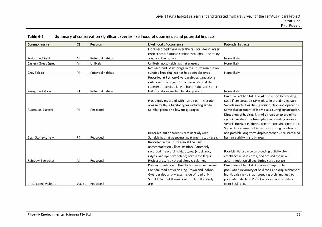
Level 1 fauna habitat assessment and targeted mulgara survey for the FerrAus Pilbara Project FerrAus Ltd
Final Report
Phoenix Environmental Sciences Pty Ltd 38
Table 6-1 Summary of conservation significant species likelihood of occurrence and potential impacts
Common name CS Records Likelihood of occurrence Potential impacts
Fork-tailed Swift M Potential habitat
Flock recorded flying over the rail corridor in larger
Project area. Suitable habitat throughout the study
area and the region. None likely
Eastern Great Egret M Unlikely Unlikely, no suitable habitat present None likely
Grey Falcon P4 Potential habitat
Not recorded. May forage in the study area but no
suitable breeding habitat has been observed. None likely
Peregrine Falcon S4 Potential habitat
Recorded at Python/Gwardar deposit and along
rail corridor in larger Project area. Most likely
transient records. Likely to hunt in the study area
but no suitable nesting habitat present. None likely
Australian Bustard P4 Recorded
Frequently recorded within and near the study
area in multiple habitat types including sandy
Spinifex plains and low rocky ranges
Direct loss of habitat. Risk of disruption to breeding
cycle if construction takes place in breeding season.
Vehicle mortalities during construction and operation.
Some displacement of individuals during construction.
Bush Stone-curlew P4 Recorded
Recorded but apparently rare in study area.
Suitable habitat at several locations in study area.
Direct loss of habitat. Risk of disruption to breeding
cycle if construction takes place in breeding season.
Vehicle mortalities during construction and operation.
Some displacement of individuals during construction
and possible long-term displacement due to increased
human activity in study area.
Rainbow Bee-eater M Recorded
Recorded in the study area at the new
accommodation village location. Commonly
recorded in several habitat types (creeklines,
ridges, and open woodland) across the larger
Project area. May breed along creeklines.
Possible disturbance to breeding activity along
creeklines in study area, and around the new
accommodation village during construction.
Crest-tailed Mulgara VU, S1 Recorded
Known population in the study area in and around
the haul road between King Brown and Python
Gwardar deposit - western side of road only.
Suitable habitat throughout much of the study
area.
Direct loss of habitat. Possible disruption to
population in vicinity of haul road and displacement of
individuals may disrupt breeding cycle and lead to
population decline. Potential for vehicle fatalities
from haul road.
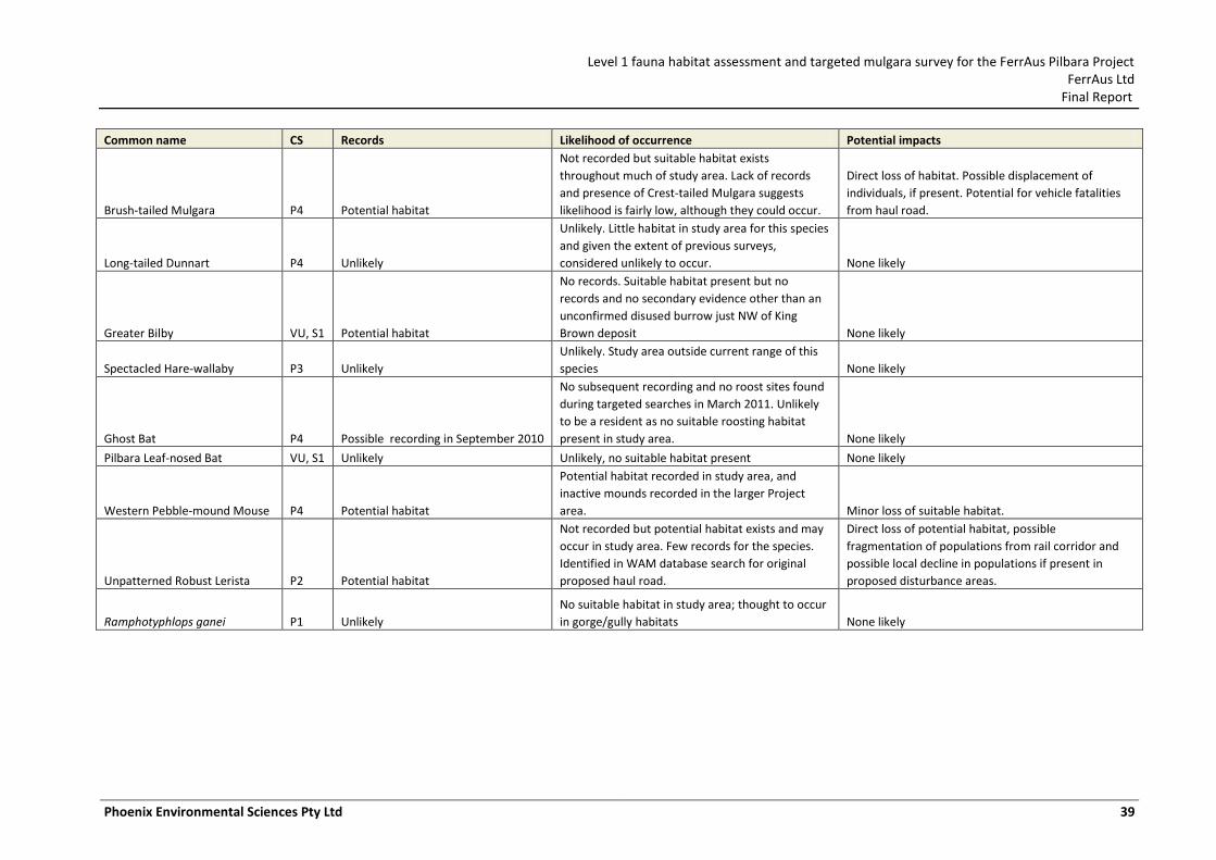
Level 1 fauna habitat assessment and targeted mulgara survey for the FerrAus Pilbara Project FerrAus Ltd
Final Report
Phoenix Environmental Sciences Pty Ltd 39
Common name CS Records Likelihood of occurrence Potential impacts
Brush-tailed Mulgara P4 Potential habitat
Not recorded but suitable habitat exists
throughout much of study area. Lack of records
and presence of Crest-tailed Mulgara suggests
likelihood is fairly low, although they could occur.
Direct loss of habitat. Possible displacement of
individuals, if present. Potential for vehicle fatalities
from haul road.
Long-tailed Dunnart P4 Unlikely
Unlikely. Little habitat in study area for this species
and given the extent of previous surveys,
considered unlikely to occur. None likely
Greater Bilby VU, S1 Potential habitat
No records. Suitable habitat present but no
records and no secondary evidence other than an
unconfirmed disused burrow just NW of King
Brown deposit None likely
Spectacled Hare-wallaby P3 Unlikely
Unlikely. Study area outside current range of this
species None likely
Ghost Bat P4 Possible recording in September 2010
No subsequent recording and no roost sites found
during targeted searches in March 2011. Unlikely
to be a resident as no suitable roosting habitat
present in study area. None likely
Pilbara Leaf-nosed Bat VU, S1 Unlikely Unlikely, no suitable habitat present None likely
Western Pebble-mound Mouse P4 Potential habitat
Potential habitat recorded in study area, and
inactive mounds recorded in the larger Project
area. Minor loss of suitable habitat.
Unpatterned Robust Lerista P2 Potential habitat
Not recorded but potential habitat exists and may
occur in study area. Few records for the species.
Identified in WAM database search for original
proposed haul road.
Direct loss of potential habitat, possible
fragmentation of populations from rail corridor and
possible local decline in populations if present in
proposed disturbance areas.
Ramphotyphlops ganei P1 Unlikely
No suitable habitat in study area; thought to occur
in gorge/gully habitats None likely
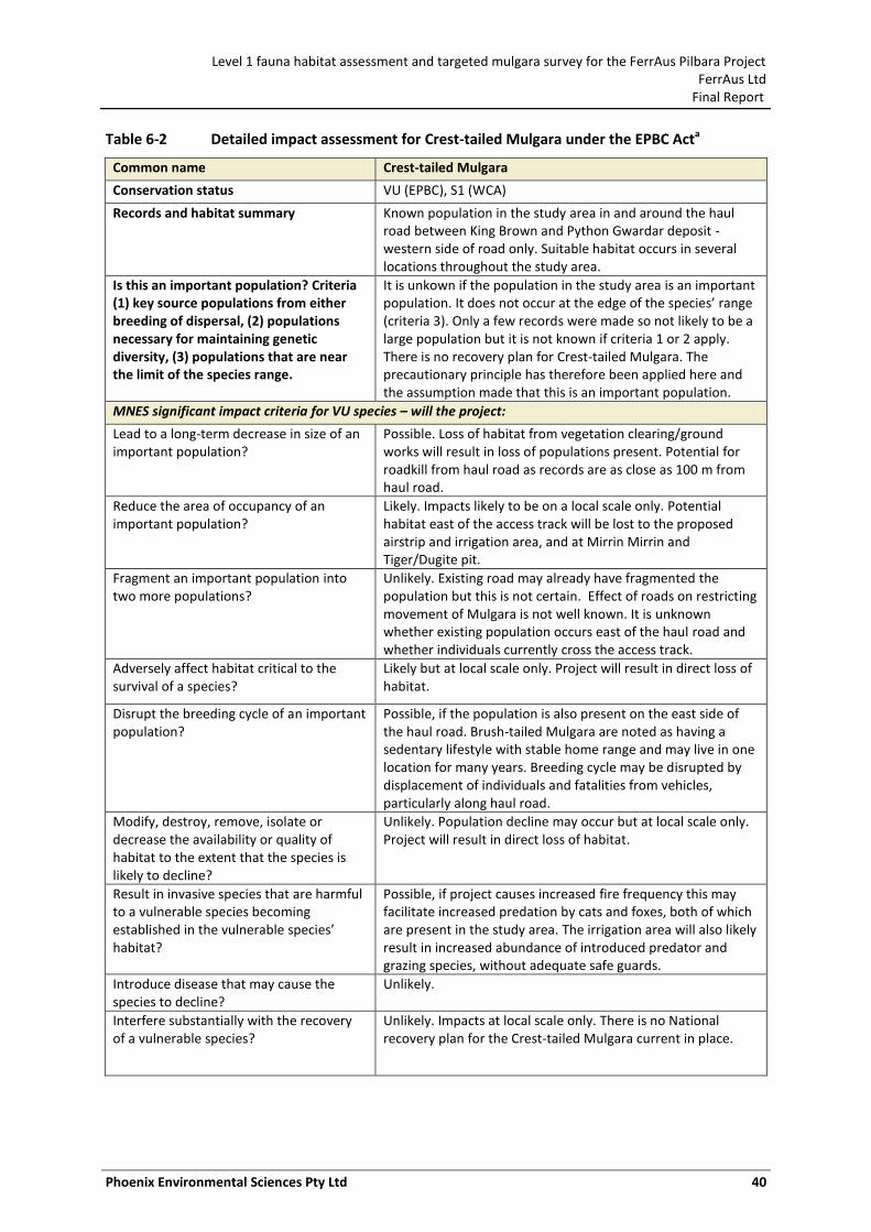
Level 1 fauna habitat assessment and targeted mulgara survey for the FerrAus Pilbara Project FerrAus Ltd
Final Report
Phoenix Environmental Sciences Pty Ltd 40
Table 6-2 Detailed impact assessment for Crest-tailed Mulgara under the EPBC Acta
Common name Crest-tailed Mulgara
Conservation status VU (EPBC), S1 (WCA)
Records and habitat summary Known population in the study area in and around the haul road between King Brown and Python Gwardar deposit - western side of road only. Suitable habitat occurs in several locations throughout the study area.
Is this an important population? Criteria (1) key source populations from either breeding of dispersal, (2) populations necessary for maintaining genetic diversity, (3) populations that are near the limit of the species range.
It is unkown if the population in the study area is an important population. It does not occur at the edge of the species’ range (criteria 3). Only a few records were made so not likely to be a large population but it is not known if criteria 1 or 2 apply. There is no recovery plan for Crest-tailed Mulgara. The precautionary principle has therefore been applied here and the assumption made that this is an important population.
MNES significant impact criteria for VU species – will the project:
Lead to a long-term decrease in size of an important population?
Possible. Loss of habitat from vegetation clearing/ground works will result in loss of populations present. Potential for roadkill from haul road as records are as close as 100 m from haul road.
Reduce the area of occupancy of an important population?
Likely. Impacts likely to be on a local scale only. Potential habitat east of the access track will be lost to the proposed airstrip and irrigation area, and at Mirrin Mirrin and Tiger/Dugite pit.
Fragment an important population into two more populations?
Unlikely. Existing road may already have fragmented the population but this is not certain. Effect of roads on restricting movement of Mulgara is not well known. It is unknown whether existing population occurs east of the haul road and whether individuals currently cross the access track.
Adversely affect habitat critical to the survival of a species?
Likely but at local scale only. Project will result in direct loss of habitat.
Disrupt the breeding cycle of an important population?
Possible, if the population is also present on the east side of the haul road. Brush-tailed Mulgara are noted as having a sedentary lifestyle with stable home range and may live in one location for many years. Breeding cycle may be disrupted by displacement of individuals and fatalities from vehicles, particularly along haul road.
Modify, destroy, remove, isolate or decrease the availability or quality of habitat to the extent that the species is likely to decline?
Unlikely. Population decline may occur but at local scale only. Project will result in direct loss of habitat.
Result in invasive species that are harmful to a vulnerable species becoming established in the vulnerable species’ habitat?
Possible, if project causes increased fire frequency this may facilitate increased predation by cats and foxes, both of which are present in the study area. The irrigation area will also likely result in increased abundance of introduced predator and grazing species, without adequate safe guards.
Introduce disease that may cause the species to decline?
Unlikely.
Interfere substantially with the recovery of a vulnerable species?
Unlikely. Impacts at local scale only. There is no National recovery plan for the Crest-tailed Mulgara current in place.
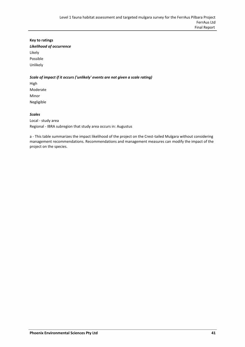
Level 1 fauna habitat assessment and targeted mulgara survey for the FerrAus Pilbara Project FerrAus Ltd
Final Report
Phoenix Environmental Sciences Pty Ltd 41
Key to ratings
Likelihood of occurrence
Likely
Possible
Unlikely
Scale of impact if it occurs ('unlikely' events are not given a scale rating)
High
Moderate
Minor
Negligible
Scales
Local - study area
Regional - IBRA subregion that study area occurs in: Augustus a - This table summarizes the impact likelihood of the project on the Crest-tailed Mulgara without considering management recommendations. Recommendations and management measures can modify the impact of the project on the species.
Level 1 fauna habitat assessment and targeted mulgara survey for the FerrAus Pilbara Project FerrAus Ltd
Final Report
Phoenix Environmental Sciences Pty Ltd 42
7 REFERENCES
BOM. 2011. Climate Statistics for Australian locations. Commonwealth of Australia, Bureau of Meterology. Available at: http://cd6bk.info/climate/data/ (accessed 1 June 2011).
Burbidge, A. H., Johnstone, R. E. & Pearson, D. J. 2010. Birds in a vast arid upland: avian biogeographical patterns in the Pilbara region of Western Australia. Records of the Western Australian Museum, Supplement 78: 247–270.
Chen, X., Dickman, C. R. & Thompson, M. B. 1998. Diet of the mulgara, Dasycercus cristicauda (Marsupialia: Dasyuridae), in the Simpson Desert, central Australia. Wildlife Research 25: 233–242.
Colloff, M. J., Hastings, A. M., Spier, F. & Devonshire, J. 2005. Centipedes of Australia. CSIRO Entomology and Australian Biological Resources Study. Available at: http://www.ento.csiro.au/biology/centipedes/centipedeKey.html (accessed 23 March 2011).
DEC. 2011. Naturemap. Department of Environment and Conservation Available at: http://naturemap.dec.wa.gov.au/default.aspx (accessed August 5 ).
Department of Agriculture. 2003. Evaporation data for Western Australia. Department of Agriculture. Resource Management Technical Report No. 65.
Desmond, A., Kendrick, P. & Chant, A. 2001. A Biodiversity Audit of Western Australia’s 53 Biogeographical Subregions in 2002. Gascoyne 3 (GAS3 – Augustus subregion). Department of Conservation and Land Mangement.
Dickman, C. R., Haythornthwaite, A. S., McNaught, G. H., Mahon, P. S., Tamayo, B. & Letnic, M. 2001. Population dynamics of three species of dasyurid marsupials in arid central Australia: a 10-year study. Wildlife Research 28: 493–506.
DSEWPC. 2011a. Dasycercus cristicauda - Mulgara. In: Species Profile and Threats Database. Department of Sustainability, Environment, Water, Population and Communities. Available at: www.environment.gov.au/cgi-bin/sprat/public/publicspecies.pl?taxon_id=328 (accessed 15 June 2011).
DSEWPC. 2011b. Maps: Australia's bioregions (IBRA). Department of Sustainability, Environment, Water, Populations and Communities. Available at: www.environment.gov.au/parks/nrs/science/bioregion-framework/ibra/index.html (accessed 10 April 2010).
DSEWPC. 2011c. Survey guidelines for Australia's threatened mammals. Guidelines for detecting mammals listed as threatened under the Environment Protection and Biodiversity Conservation Act 1999. Department of Sustainability, Environment, Water, Population and Communities.
Ecologia. 2006. Hashimoto terrestrial fauna survey. Ecologia Environment Pty Ltd. Unpublished report prepared for BHP Billiton Iron Ore Pty Ltd.
Ecologia. 2007a. Robertson Range - Proposed haul road biological survey. Ecologia Environment Pty Ltd. Unpublished report prepared for FerrAus Ltd.
Ecologia. 2007b. Robertson Range biological survey. Ecologia Environment Pty Ltd. Unpublished report prepared for FerrAus Ltd.
Ecologia. 2007c. Robertson Range Iron Ore Project. Short-range endemic desktop review. Ecologia Environment Pty Ltd. Unpublished report prepared for FerrAus Ltd.
Level 1 fauna habitat assessment and targeted mulgara survey for the FerrAus Pilbara Project FerrAus Ltd
Final Report
Phoenix Environmental Sciences Pty Ltd 43
Ecologia. 2008. Robertson Range fauna survey. Ecologia Environment Pty Ltd. Unpublished report prepared for FerrAus Ltd.
EPA. 2002. Position statement no. 3. Terrestrial biological surveys as an element of biodiversity protection. Environmental Protection Authority.
EPA. 2004. Guidance for the assessment of environmental factors (in accordance with the Environmental Protection Act 1986). Terrestrial fauna surveys for Environmental Impact Assessment in Western Australia. No. 56. Environmental Protection Authority.
EPA. 2009. Guidance for the assessment of environmental factors (in accordance with the Environmental Protection Act 1986). Sampling of short range invertebrate fauna for environmental impact assessment in Western Australia. No. 20. Environmental Protection Authority.
EPA & DEC. 2010. Technical guide - terrestrial vertebrate fauna surveys for Environmental Impact Assessment. Environmental Protection Authority and Department of Environment and Conservation.
FMG. 2011. Cloudbreak life of mine Public Environmental Review. Fortescue Metals Group Ltd.
Garnett, S. T. & Crowley, G. M. 2000. The Action Plan for Australian birds 2000. Birds Australia, Environment Australia.
Gibson, L. A. & McKenzie, N. L. 2009. Environmental associations of small ground-dwelling mammals in the Pilbara region, Western Australia. Records of the Western Australian Museum, Supplement 78: 91–122.
Guthrie, N. A., Weir, T. & Will, K. 2010. Localised and regional patterns in ground-dwelling beetle assemblages in a semi-tropical arid zone environment. Records of the Western Australian Museum, Supplement 78: 169–184.
Harvey, M. S. 2002. Short-range endemism among the Australian fauna: some examples from non-marine environments. Invertebrate Systematics 16: 555–570.
Harvey, M. S., Berry, O., Edward, K. L. & Humphreys, G. 2008. Molecular and morphological systematics of hypogean schizomids (Schizomida: Hubbardiidae) in semiarid Australia. Invertebrate Systematics 22: 167–194.
Johnstone, R. E. & Storr, G. M. 1998. Handbook of Western Australian birds. Volume 1: Non-passerines (Emu to Dollarbird). Western Australian Museum, Perth, WA.
Keighery, G. 2010. The naturalised vascular plants of the Pilbara region, Western Australia. Records of the Western Australian Museum, Supplement 78: 299–311.
Koch, L. E. 1982. Taxonomy of the centipede Scolopendra laeta Haase (Chilopoda: Scolopendridae) in Australia. Zoological Journal of the Linnean Society 76: 125–140.
Koch, L. E. 1983a. Morphological characters of Australian scolopendrid centipedes, and the taxonomy and distribution of Scolopendra morsitans L. (Chilopoda: Scolopendridae: Scolopendrinae). Australian Journal of Zoology 31: 79–91.
Koch, L. E. 1983b. Revision of the Australian centipedes of the genus Cormocephalus Newport (Chilopoda: Scolopendridae: Scolopendrinae). Australian Journal of Zoology 31: 799–833.
Koch, L. E. 1983c. A taxonomic study of the centipede genus Ethmostigmus Pocock (Chilopoda: Scolopendridae: Otostigminae) in Australia. Australian Journal of Zoology 31: 835–849.
Körtner, G., Pavey, C. R. & Geiser, F. 2007. Spatial ecology of the mulgara in arid Australia: impact of fire history on home range size and burrow use. Journal of Zoology 273: 350–357.
Level 1 fauna habitat assessment and targeted mulgara survey for the FerrAus Pilbara Project FerrAus Ltd
Final Report
Phoenix Environmental Sciences Pty Ltd 44
Letnic, M. & Dickman, C. R. 2005. The responses of small mammals to patches regenerating after fire and rainfall in the Simpson Desert, central Australia. Austral Ecology 30: 24–39.
Masters, P. 1993. The effects of fire-driven succession and rainfall on small mammals in spinifex grassland at Uluru National Park, Northern Territory. Wildlife Research 20: 803–813.
Masters, P. 2003. Movement patterns and spatial organisation of the mulgara, Dasycercus cristicauda (Marsupialia: Dasyuridae), in central Australia. Wildlife Research 30: 339–344.
Masters, P. 2008. Crest-tailed Mulgara: Dasycercus cristicauda. In: Van Dyck, S.&Strahan, R. (eds) The Mammals of Australia, Third Edition. Reed New Holland Publishers, Sydney, NSW, pp. 49–50.
Masters, P., Dickman, C. R. & Crowther, M. 2003. Effects of cover reduction on mulgara Dasycercus cristicauda (Marsupialia: Dasyuridae), rodent and invertebrate populations in central Australia: Implications for land management. Austral Ecology 28: 658–665.
Maxwell, S., Burbidge, A. A. & Morris, K. D. 1996. The 1996 action plan for Australian marsupials and monotremes. Wildlife Australia.
McKenzie, N. L. & Bullen, R. D. 2009. The echolocation calls, habitat relationships, foraging niches and communities of Pilbara microbats. Records of the Western Australian Museum, Supplement 78: 123–155.
McKenzie, N. L. & Burbidge, A. A. 2002. Mammals. In: Sattler, P.&Creighton, C. (eds) Australian terrestrial biodiversity assessment 2002, Canberra, ACT.
McKenzie, N. L., van Leeuwen, S. & Pinder, A. M. 2009. Introduction to the Pilbara Biodiversity Survey, 2002–2007. Records of the Western Australian Museum, Supplement 78: 3–89.
Phoenix. 2009. Davidson Creek Iron Ore Project. Short-range endemic Invertebrate fauna survey. Phoenix Environmental Sciences. Unpublished report prepared for Strategen Pty Ltd (for FerrAus Ltd).
Phoenix. 2010a. FerrAus Pilbara Project, Level 2 Vertebrate Fauna Survey. Phoenix Environmental Sciences Pty Ltd. Unpublished report prepared for FerrAus Ltd.
Phoenix. 2010b. Short-range endemic invertebrate fauna report: FerrAus Pilbara Project. Phoenix Environmental Sciences Pty Ltd. Unpublished report prepared for FerrAus Ltd.
Phoenix. 2011a. Consolidated report on vertebrate fauna surveys conducted for the FerrAus Pilbara Project. Phoenix Environmental Sciences Pty Ltd.
Phoenix. 2011b. Level 1 fauna survey and desktop review for the Roy Hill Infrastructure Project - Bonney Downs alignment. Phoenix Environmental Sciences Pty Ltd. Unpublished report prepared for Roy Hill Infrastructure Pty Ltd.
Richter, V. & Freegard, C. 2009. Standard Operating Procedure No. 12.2. Permanent marking of mammals using ear notching. Department of Environment and Conservation. Unpublished report SOP No. 12.2 prepared for the DEC Animal Ethics Committee.
Thackway, R. & Cresswell, I. D. 1995a. An Interim Biogeographic Regionalisation for Australia. Australian Nature Conservation Agency, Reserve System Unit,Canberra.
Thackway, R. & Cresswell, I. D. 1995b. An Interim Biogeographic Regionalisation for Australia: a framework for establishing the national system of reserves, Version 4.0. Australian Nature Conservation Agency, Canberra, ACT.
Thompson, G. G. & Thompson, S. A. 2007. Shape and spatial distribution of Mulgara (Dasycercus cristicauda) burrows, with comments on their presence in a burnt habitat and a translocation protocol. Journal of the Royal Society of Western Australia 90: 195–202.
Level 1 fauna habitat assessment and targeted mulgara survey for the FerrAus Pilbara Project FerrAus Ltd
Final Report
Phoenix Environmental Sciences Pty Ltd 45
Thompson, G. G. & Thompson, S. A. 2008. Abundance and spatial distribution of five small mammals at a local scale. Australian Mammalogy 30: 65–70.
Thompson, S. A. & Thompson, G. G. 2010. Terrestrial vertebrate fauna assessments for ecological impact assessments. Terrestrial Ecosystems.
Van Dyck, S. & Strahan, R. 2008. The mammals of Australia New Holland Publishers, Sydney, NSW.
Van Vreeswyk, A. M. E., Payne, A. L., Leighton, K. A. & Hennig, P. 2004. An inventory and condition survey of the Pilbara region, Western Australia. Department of Agriculture, Government of Australia, Technical Bulletin 92: 1–58.
Wojcieszek, J. M., Harvey, M. S. & Rix, M. G. 2011. Optimised captive husbandry conditions for the Western Australian 'Marri Millipede' Antichiropus variabilis (Diplopoda: Polydesmida: Paradoxosomatidae), with notes on natural history and tissue preservation techniques. Records of the Western Australian Museum 26: 87–93.
Woolley, P. 2008a. Dasycercus blythi. In: IUCN Red List of Threatened Species. Version 2011.1. IUCN 2011. Available at: www.iucnredlist.org (accessed 10 April 2011).
Woolley, P. 2008b. Dasycercus cristicauda. In: IUCN Red List of Threatened Species. Version 2011.1. IUCN 2011. Available at: www.iucnredlist.org (accessed 15 June 2011).
Woolley, P. A. 1990. Mulgaras, Dasycercus cristicauda (Marsupialia: Dasyuridae); their burrows, and records of attempts to collect live animals between 1966 and 1979. Australian Mammalogy 13: 61–64.
Woolley, P. A. 2005. The species of Dasycercus Peters, 1875 (Marsupialia: Dasyuridae). Memoirs of Museum Victoria 62: 213–221.
Woolley, P. A. 2006. Studies on the Crest-tailed Mulgara Dasycercus cristicauda and the Brush-tailed Mulgara Dasycercus blythi (Marsupialia: Dasyuridae). Australian Mammalogy 28: 117–120.
Woolley, P. A. 2008c. Brush-tailed Mulgara: Dasycercus blythi. In: Van Dyck, S.&Strahan, R. (eds) The Mammals of Australia. Reed New Holland Publishers, Sydney, pp. L47–48.
Level 1 fauna habitat assessment and targeted mulgara survey for the FerrAus Pilbara Project FerrAus Ltd
Final Report
Phoenix Environmental Sciences Pty Ltd 46
APPENDIX 1 HABITAT DESCRIPTIONS FOR LEVEL 1 FAUNA HABITAT ASSESSMENT SITES
Site Village 1 (7402190; 251965 51K)
Date 16/03/2011
Habitat Footslope
Description Scattered acacia low trees over moderately dense acacia shrubs, over dense spinifex on orange sandy clay soil.
Dominant tree Acacia (not Mulga)
Dominant grass Spinifex
Tree Cover (%) 0-25
Shrub Cover (%) 26-50
Grass Cover (%) 76-100
Drainage None
Slope Moderate
Soil Texture Sandy clay
Soil Colour Orange
Surface Surface crust
Rock Cover (%)
Leaf Litter Cover (%) 0-25%
Dead Wood Moderate
Disturbance None evident
Fire History None evident
Observed Fauna (direct or secondary evidence)
Rainbow Bee-eater (Merops ornatus); Red Kangaroo (Macropus rufus) (tracks, diggings); Dog (Canis lupus familiaris) (tracks)
Potential Conservation Significant Fauna Habitat
Crested-tailed Mulgara (Dasycercus cristicauda); Brush-tailed Mulgara (Dasycercus blythi); Greater Bilby (Macrotis lagotis); Fork-tailed Swift (Apus pacificus); Australian Bustard (Ardeotis australis); Bush Stone-curlew (Burhinus grallarius); Oriental Plover (Charadrius veredus); Grey Falcon (Falco hypoleucos); Rainbow Bee-eater (Merops ornatus); Unpatterned Robust Lerista (Lerista macropisthopus remota)
Level 1 fauna habitat assessment and targeted mulgara survey for the FerrAus Pilbara Project FerrAus Ltd
Final Report
Phoenix Environmental Sciences Pty Ltd 47
Site Village 2 (7402233; 252081 51K)
Date 16/03/2011
Habitat Footslope
Description Hill and surrounding slopes. Scattered mulga trees over moderately dense spinifex on rocky orange clay; associated minor drainage.
Dominant tree Mulga
Dominant grass Spinifex
Tree Cover (%) 26-50
Shrub Cover (%) 26-50
Grass Cover (%) 51-75
Drainage
Slope Moderate
Soil Texture Clay
Soil Colour Orange
Surface Surface crust; fine gravel; coarse gravel
Rock Cover (%) 50-90% cover
Leaf Litter Cover (%) 0-25%
Dead Wood Moderate
Disturbance None evident
Fire History 5-10 Years
Observed Fauna (direct or secondary evidence)
Australian Bustard (Ardeotis australis) (tracks); Rainbow Bee-eater (Merops ornatus); Gehyra variegata; Dog (Canis lupus familiaris) (tracks)
Potential Conservation Significant Fauna Habitat
Western Pebble-mound Mouse (Pseudomys chapmani); Fork-tailed Swift (Apus pacificus); Australian Bustard (Ardeotis australis); Peregrine Falcon (Falco peregrinus); Rainbow Bee-eater (Merops ornatus)
Level 1 fauna habitat assessment and targeted mulgara survey for the FerrAus Pilbara Project FerrAus Ltd
Final Report
Phoenix Environmental Sciences Pty Ltd 48
Site Village 3 (7403057; 252543 51K)
Date 16/03/2011
Habitat Ridgetop
Description Very widely scattered acacias over dense spinifex on rocky orange clay.
Dominant tree Acacia (not Mulga)
Dominant grass Spinifex
Tree Cover (%) 0-25
Shrub Cover (%) 0-25
Grass Cover (%) 76-100
Drainage None
Slope Moderate
Soil Texture Peat
Soil Colour Orange
Surface Fine gravel; coarse gravel;
Rock Cover (%) 25-50
Leaf Litter Cover (%) 0-25
Dead Wood Negligible
Disturbance
Fire History None evident
Observed Fauna (direct or secondary evidence)
Ringtail Dragon (Ctenophorus caudicinctus)
Potential Conservation Significant Fauna Habitat
Western Pebble-mound Mouse (Pseudomys chapmani); Fork-tailed Swift (Apus pacificus); Australian Bustard (Ardeotis australis); Peregrine Falcon (Falco peregrinus); Rainbow Bee-eater (Merops ornatus)
Level 1 fauna habitat assessment and targeted mulgara survey for the FerrAus Pilbara Project FerrAus Ltd
Final Report
Phoenix Environmental Sciences Pty Ltd 49
Site Village 4 (7402951; 252730 51K)
Date 16/03/2011
Habitat Plain
Description Widely scattered acacia over dense mixed spinifex with tussock grasses and Eremophila on soft red sand.
Dominant tree Acacia (not Mulga)
Dominant grass Spinifex
Tree Cover (%) 0-25
Shrub Cover (%) 0-25
Grass Cover (%) 76-100
Drainage None
Slope Negligible
Soil Texture Sand
Soil Colour Red
Surface Fine gravel; coarse gravel
Rock Cover (%) 0-25
Leaf Litter Cover (%) 0-25
Dead Wood Negligible
Disturbance
Fire History 5-10 Years
Observed Fauna (direct or secondary evidence)
Rainbow Bee-eater (Merops ornatus); Australian Bustard (Ardeotis australis) (tracks); Camel (Camelus dromedarius) (tracks)
Potential Conservation Significant Fauna Habitat
Crested-tailed Mulgara (Dasycercus cristicauda); Brush-tailed Mulgara (Dasycercus blythi); Greater Bilby (Macrotis lagotis); Fork-tailed Swift (Apus pacificus); Australian Bustard (Ardeotis australis); Bush Stone-curlew (Burhinus grallarius); Oriental Plover (Charadrius veredus); Grey Falcon (Falco hypoleucos); Rainbow Bee-eater (Merops ornatus); Unpatterned Robust Lerista (Lerista macropisthopus remota)
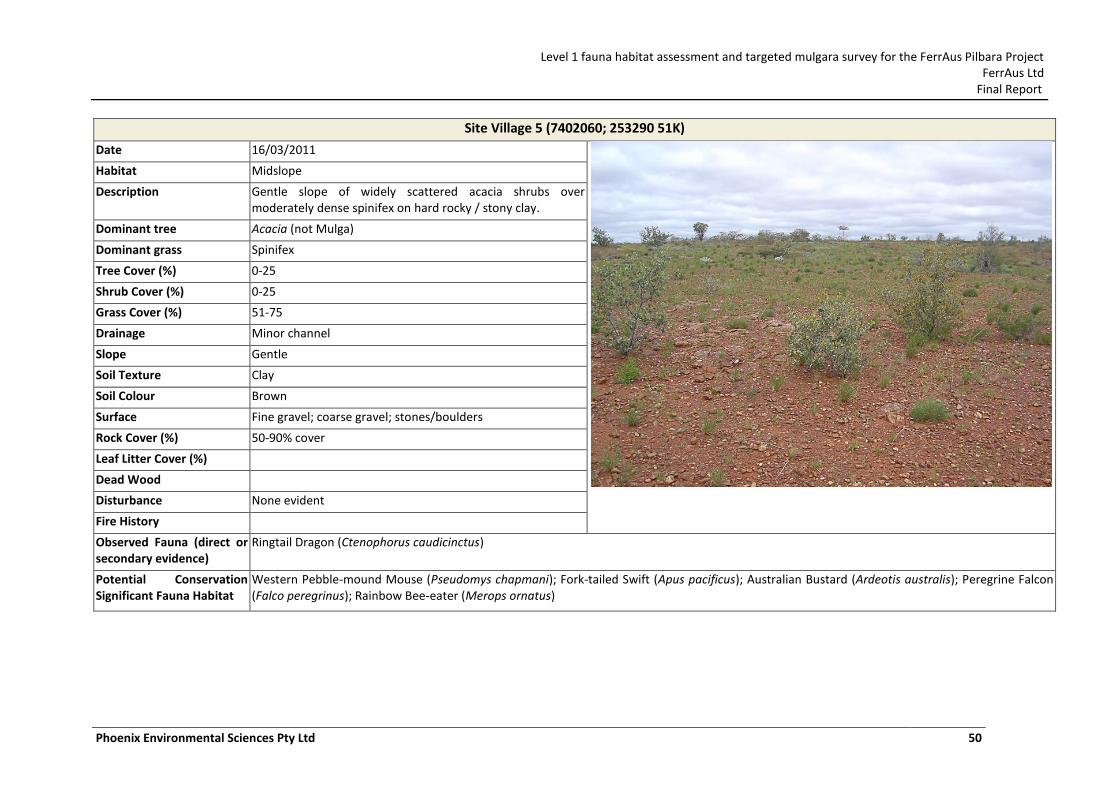
Level 1 fauna habitat assessment and targeted mulgara survey for the FerrAus Pilbara Project FerrAus Ltd
Final Report
Phoenix Environmental Sciences Pty Ltd 50
Site Village 5 (7402060; 253290 51K)
Date 16/03/2011
Habitat Midslope
Description Gentle slope of widely scattered acacia shrubs over moderately dense spinifex on hard rocky / stony clay.
Dominant tree Acacia (not Mulga)
Dominant grass Spinifex
Tree Cover (%) 0-25
Shrub Cover (%) 0-25
Grass Cover (%) 51-75
Drainage Minor channel
Slope Gentle
Soil Texture Clay
Soil Colour Brown
Surface Fine gravel; coarse gravel; stones/boulders
Rock Cover (%) 50-90% cover
Leaf Litter Cover (%)
Dead Wood
Disturbance None evident
Fire History
Observed Fauna (direct or secondary evidence)
Ringtail Dragon (Ctenophorus caudicinctus)
Potential Conservation Significant Fauna Habitat
Western Pebble-mound Mouse (Pseudomys chapmani); Fork-tailed Swift (Apus pacificus); Australian Bustard (Ardeotis australis); Peregrine Falcon (Falco peregrinus); Rainbow Bee-eater (Merops ornatus)
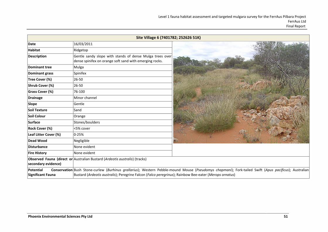
Level 1 fauna habitat assessment and targeted mulgara survey for the FerrAus Pilbara Project FerrAus Ltd
Final Report
Phoenix Environmental Sciences Pty Ltd 51
Site Village 6 (7401782; 252626 51K)
Date 16/03/2011
Habitat Ridgetop
Description Gentle sandy slope with stands of dense Mulga trees over dense spinifex on orange soft sand with emerging rocks.
Dominant tree Mulga
Dominant grass Spinifex
Tree Cover (%) 26-50
Shrub Cover (%) 26-50
Grass Cover (%) 76-100
Drainage Minor channel
Slope Gentle
Soil Texture Sand
Soil Colour Orange
Surface Stones/boulders
Rock Cover (%) <5% cover
Leaf Litter Cover (%) 0-25%
Dead Wood Negligible
Disturbance None evident
Fire History None evident
Observed Fauna (direct or secondary evidence)
Australian Bustard (Ardeotis australis) (tracks)
Potential Conservation Significant Fauna
Bush Stone-curlew (Burhinus grallarius); Western Pebble-mound Mouse (Pseudomys chapmani); Fork-tailed Swift (Apus pacificus); Australian Bustard (Ardeotis australis); Peregrine Falcon (Falco peregrinus); Rainbow Bee-eater (Merops ornatus)
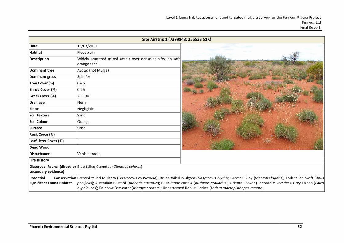
Level 1 fauna habitat assessment and targeted mulgara survey for the FerrAus Pilbara Project FerrAus Ltd
Final Report
Phoenix Environmental Sciences Pty Ltd 52
Site Airstrip 1 (7399848; 255533 51K)
Date 16/03/2011
Habitat Floodplain
Description Widely scattered mixed acacia over dense spinifex on soft orange sand.
Dominant tree Acacia (not Mulga)
Dominant grass Spinifex
Tree Cover (%) 0-25
Shrub Cover (%) 0-25
Grass Cover (%) 76-100
Drainage None
Slope Negligible
Soil Texture Sand
Soil Colour Orange
Surface Sand
Rock Cover (%)
Leaf Litter Cover (%)
Dead Wood
Disturbance Vehicle tracks
Fire History
Observed Fauna (direct or secondary evidence)
Blue-tailed Ctenotus (Ctenotus calurus)
Potential Conservation Significant Fauna Habitat
Crested-tailed Mulgara (Dasycercus cristicauda); Brush-tailed Mulgara (Dasycercus blythi); Greater Bilby (Macrotis lagotis); Fork-tailed Swift (Apus pacificus); Australian Bustard (Ardeotis australis); Bush Stone-curlew (Burhinus grallarius); Oriental Plover (Charadrius veredus); Grey Falcon (Falco hypoleucos); Rainbow Bee-eater (Merops ornatus); Unpatterned Robust Lerista (Lerista macropisthopus remota)
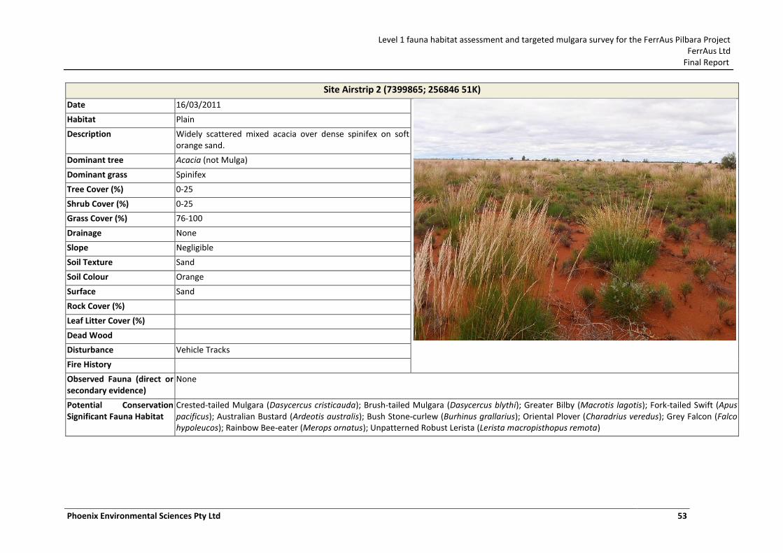
Level 1 fauna habitat assessment and targeted mulgara survey for the FerrAus Pilbara Project FerrAus Ltd
Final Report
Phoenix Environmental Sciences Pty Ltd 53
Site Airstrip 2 (7399865; 256846 51K)
Date 16/03/2011
Habitat Plain
Description Widely scattered mixed acacia over dense spinifex on soft orange sand.
Dominant tree Acacia (not Mulga)
Dominant grass Spinifex
Tree Cover (%) 0-25
Shrub Cover (%) 0-25
Grass Cover (%) 76-100
Drainage None
Slope Negligible
Soil Texture Sand
Soil Colour Orange
Surface Sand
Rock Cover (%)
Leaf Litter Cover (%)
Dead Wood
Disturbance Vehicle Tracks
Fire History
Observed Fauna (direct or secondary evidence)
None
Potential Conservation Significant Fauna Habitat
Crested-tailed Mulgara (Dasycercus cristicauda); Brush-tailed Mulgara (Dasycercus blythi); Greater Bilby (Macrotis lagotis); Fork-tailed Swift (Apus pacificus); Australian Bustard (Ardeotis australis); Bush Stone-curlew (Burhinus grallarius); Oriental Plover (Charadrius veredus); Grey Falcon (Falco hypoleucos); Rainbow Bee-eater (Merops ornatus); Unpatterned Robust Lerista (Lerista macropisthopus remota)
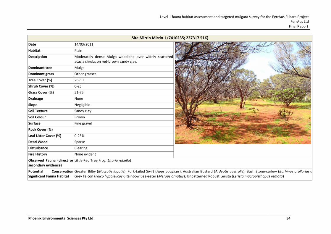
Level 1 fauna habitat assessment and targeted mulgara survey for the FerrAus Pilbara Project FerrAus Ltd
Final Report
Phoenix Environmental Sciences Pty Ltd 54
Site Mirrin Mirrin 1 (7410235; 237317 51K)
Date 14/03/2011
Habitat Plain
Description Moderately dense Mulga woodland over widely scattered acacia shrubs on red-brown sandy clay.
Dominant tree Mulga
Dominant grass Other grasses
Tree Cover (%) 26-50
Shrub Cover (%) 0-25
Grass Cover (%) 51-75
Drainage None
Slope Negligible
Soil Texture Sandy clay
Soil Colour Brown
Surface Fine gravel
Rock Cover (%)
Leaf Litter Cover (%) 0-25%
Dead Wood Sparse
Disturbance Clearing
Fire History None evident
Observed Fauna (direct or secondary evidence)
Little Red Tree Frog (Litoria rubella)
Potential Conservation Significant Fauna Habitat
Greater Bilby (Macrotis lagotis); Fork-tailed Swift (Apus pacificus); Australian Bustard (Ardeotis australis); Bush Stone-curlew (Burhinus grallarius); Grey Falcon (Falco hypoleucos); Rainbow Bee-eater (Merops ornatus); Unpatterned Robust Lerista (Lerista macropisthopus remota)
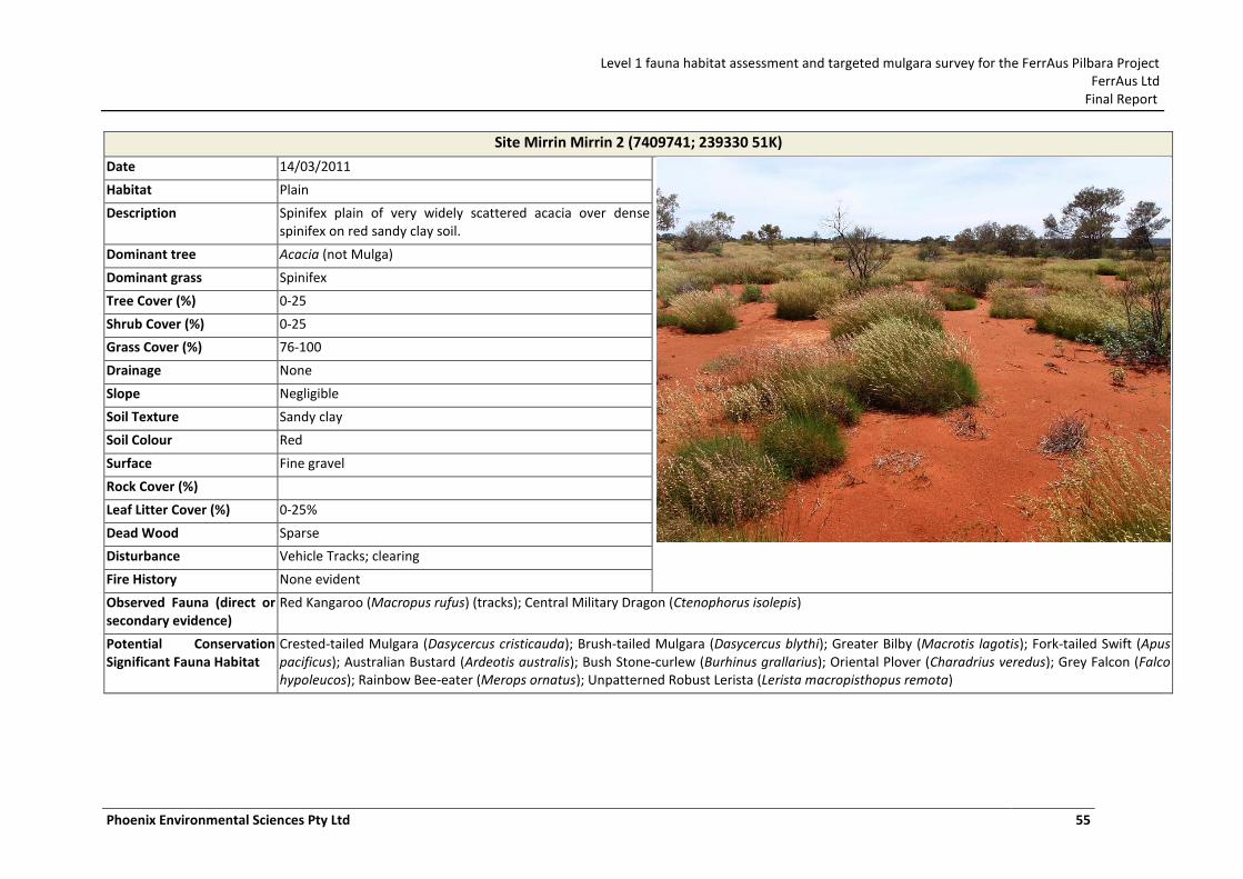
Level 1 fauna habitat assessment and targeted mulgara survey for the FerrAus Pilbara Project FerrAus Ltd
Final Report
Phoenix Environmental Sciences Pty Ltd 55
Site Mirrin Mirrin 2 (7409741; 239330 51K)
Date 14/03/2011
Habitat Plain
Description Spinifex plain of very widely scattered acacia over dense spinifex on red sandy clay soil.
Dominant tree Acacia (not Mulga)
Dominant grass Spinifex
Tree Cover (%) 0-25
Shrub Cover (%) 0-25
Grass Cover (%) 76-100
Drainage None
Slope Negligible
Soil Texture Sandy clay
Soil Colour Red
Surface Fine gravel
Rock Cover (%)
Leaf Litter Cover (%) 0-25%
Dead Wood Sparse
Disturbance Vehicle Tracks; clearing
Fire History None evident
Observed Fauna (direct or secondary evidence)
Red Kangaroo (Macropus rufus) (tracks); Central Military Dragon (Ctenophorus isolepis)
Potential Conservation Significant Fauna Habitat
Crested-tailed Mulgara (Dasycercus cristicauda); Brush-tailed Mulgara (Dasycercus blythi); Greater Bilby (Macrotis lagotis); Fork-tailed Swift (Apus pacificus); Australian Bustard (Ardeotis australis); Bush Stone-curlew (Burhinus grallarius); Oriental Plover (Charadrius veredus); Grey Falcon (Falco hypoleucos); Rainbow Bee-eater (Merops ornatus); Unpatterned Robust Lerista (Lerista macropisthopus remota)
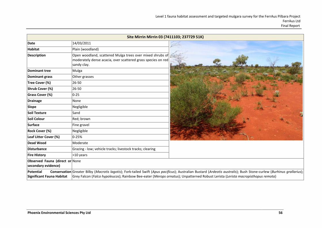
Level 1 fauna habitat assessment and targeted mulgara survey for the FerrAus Pilbara Project FerrAus Ltd
Final Report
Phoenix Environmental Sciences Pty Ltd 56
Site Mirrin Mirrin 03 (7411103; 237729 51K)
Date 14/03/2011
Habitat Plain (woodland)
Description Open woodland, scattered Mulga trees over mixed shrubs of moderately dense acacia, over scattered grass species on red sandy clay.
Dominant tree Mulga
Dominant grass Other grasses
Tree Cover (%) 26-50
Shrub Cover (%) 26-50
Grass Cover (%) 0-25
Drainage None
Slope Negligible
Soil Texture Sand
Soil Colour Red; brown
Surface Fine gravel
Rock Cover (%) Negligible
Leaf Litter Cover (%) 0-25%
Dead Wood Moderate
Disturbance Grazing - low; vehicle tracks; livestock tracks; clearing
Fire History >10 years
Observed Fauna (direct or secondary evidence)
None
Potential Conservation Significant Fauna Habitat
Greater Bilby (Macrotis lagotis); Fork-tailed Swift (Apus pacificus); Australian Bustard (Ardeotis australis); Bush Stone-curlew (Burhinus grallarius); Grey Falcon (Falco hypoleucos); Rainbow Bee-eater (Merops ornatus); Unpatterned Robust Lerista (Lerista macropisthopus remota)
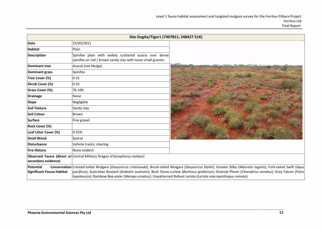
Level 1 fauna habitat assessment and targeted mulgara survey for the FerrAus Pilbara Project FerrAus Ltd
Final Report
Phoenix Environmental Sciences Pty Ltd 57
Site Dugite/Tiger1 (7407811; 248427 51K)
Date 15/03/2011
Habitat Plain
Description Spinifex plain with widely scattered acacia over dense spinifex on red / brown sandy clay with loose small gravels.
Dominant tree Acacia (not Mulga)
Dominant grass Spinifex
Tree Cover (%) 0-25
Shrub Cover (%) 0-25
Grass Cover (%) 76-100
Drainage None
Slope Negligible
Soil Texture Sandy clay
Soil Colour Brown
Surface Fine gravel
Rock Cover (%)
Leaf Litter Cover (%) 0-25%
Dead Wood Sparse
Disturbance Vehicle tracks; clearing
Fire History None evident
Observed Fauna (direct or secondary evidence)
Central Military Dragon (Ctenophorus isolepis)
Potential Conservation Significant Fauna Habitat
Crested-tailed Mulgara (Dasycercus cristicauda); Brush-tailed Mulgara (Dasycercus blythi); Greater Bilby (Macrotis lagotis); Fork-tailed Swift (Apus pacificus); Australian Bustard (Ardeotis australis); Bush Stone-curlew (Burhinus grallarius); Oriental Plover (Charadrius veredus); Grey Falcon (Falco hypoleucos); Rainbow Bee-eater (Merops ornatus); Unpatterned Robust Lerista (Lerista macropisthopus remota)
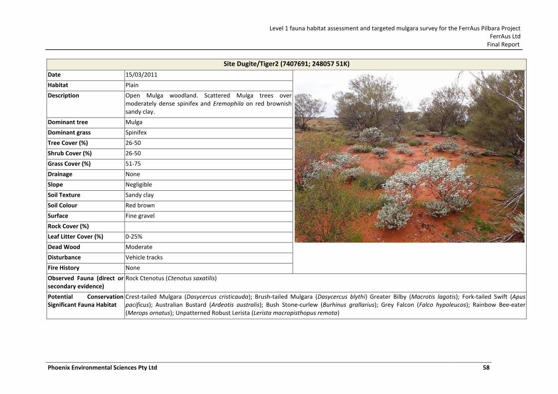
Level 1 fauna habitat assessment and targeted mulgara survey for the FerrAus Pilbara Project FerrAus Ltd
Final Report
Phoenix Environmental Sciences Pty Ltd 58
Site Dugite/Tiger2 (7407691; 248057 51K)
Date 15/03/2011
Habitat Plain
Description Open Mulga woodland. Scattered Mulga trees over moderately dense spinifex and Eremophila on red brownish sandy clay.
Dominant tree Mulga
Dominant grass Spinifex
Tree Cover (%) 26-50
Shrub Cover (%) 26-50
Grass Cover (%) 51-75
Drainage None
Slope Negligible
Soil Texture Sandy clay
Soil Colour Red brown
Surface Fine gravel
Rock Cover (%)
Leaf Litter Cover (%) 0-25%
Dead Wood Moderate
Disturbance Vehicle tracks
Fire History None
Observed Fauna (direct or secondary evidence)
Rock Ctenotus (Ctenotus saxatilis)
Potential Conservation Significant Fauna Habitat
Crest-tailed Mulgara (Dasycercus cristicauda); Brush-tailed Mulgara (Dasycercus blythi) Greater Bilby (Macrotis lagotis); Fork-tailed Swift (Apus pacificus); Australian Bustard (Ardeotis australis); Bush Stone-curlew (Burhinus grallarius); Grey Falcon (Falco hypoleucos); Rainbow Bee-eater (Merops ornatus); Unpatterned Robust Lerista (Lerista macropisthopus remota)
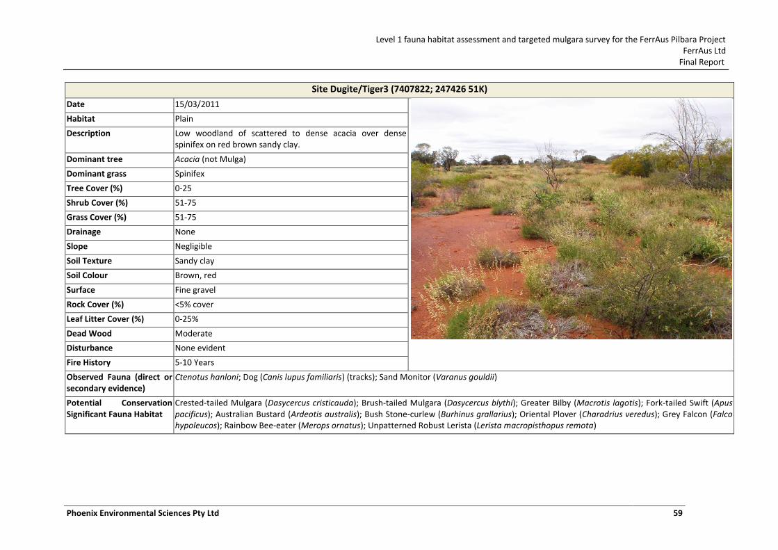
Level 1 fauna habitat assessment and targeted mulgara survey for the FerrAus Pilbara Project FerrAus Ltd
Final Report
Phoenix Environmental Sciences Pty Ltd 59
Site Dugite/Tiger3 (7407822; 247426 51K)
Date 15/03/2011
Habitat Plain
Description Low woodland of scattered to dense acacia over dense spinifex on red brown sandy clay.
Dominant tree Acacia (not Mulga)
Dominant grass Spinifex
Tree Cover (%) 0-25
Shrub Cover (%) 51-75
Grass Cover (%) 51-75
Drainage None
Slope Negligible
Soil Texture Sandy clay
Soil Colour Brown, red
Surface Fine gravel
Rock Cover (%) <5% cover
Leaf Litter Cover (%) 0-25%
Dead Wood Moderate
Disturbance None evident
Fire History 5-10 Years
Observed Fauna (direct or secondary evidence)
Ctenotus hanloni; Dog (Canis lupus familiaris) (tracks); Sand Monitor (Varanus gouldii)
Potential Conservation Significant Fauna Habitat
Crested-tailed Mulgara (Dasycercus cristicauda); Brush-tailed Mulgara (Dasycercus blythi); Greater Bilby (Macrotis lagotis); Fork-tailed Swift (Apus pacificus); Australian Bustard (Ardeotis australis); Bush Stone-curlew (Burhinus grallarius); Oriental Plover (Charadrius veredus); Grey Falcon (Falco hypoleucos); Rainbow Bee-eater (Merops ornatus); Unpatterned Robust Lerista (Lerista macropisthopus remota)
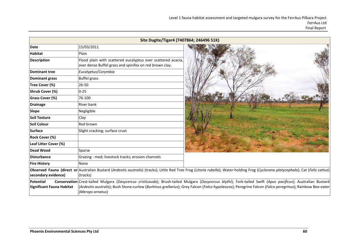
Level 1 fauna habitat assessment and targeted mulgara survey for the FerrAus Pilbara Project FerrAus Ltd
Final Report
Phoenix Environmental Sciences Pty Ltd 60
Site Dugite/Tiger4 (7407864; 246496 51K)
Date 15/03/2011
Habitat Plain
Description Flood plain with scattered eucalyptus over scattered acacia, over dense Buffel grass and spinifex on red brown clay.
Dominant tree Eucalyptus/Corymbia
Dominant grass Buffel grass
Tree Cover (%) 26-50
Shrub Cover (%) 0-25
Grass Cover (%) 76-100
Drainage River bank
Slope Negligible
Soil Texture Clay
Soil Colour Red brown
Surface Slight cracking; surface crust
Rock Cover (%)
Leaf Litter Cover (%)
Dead Wood Sparse
Disturbance Grazing - med; livestock tracks; erosion channels
Fire History None
Observed Fauna (direct or secondary evidence)
Australian Bustard (Ardeotis australis) (tracks); Little Red Tree Frog (Litoria rubella); Water-holding Frog (Cyclorana platycephala); Cat (Felis cattus) (tracks)
Potential Conservation Significant Fauna Habitat
Crest-tailed Mulgara (Dasycercus cristicauda); Brush-tailed Mulgara (Dasycercus blythi); Fork-tailed Swift (Apus pacificus); Australian Bustard (Ardeotis australis); Bush Stone-curlew (Burhinus grallarius); Grey Falcon (Falco hypoleucos); Peregrine Falcon (Falco peregrinus); Rainbow Bee-eater (Merops ornatus)
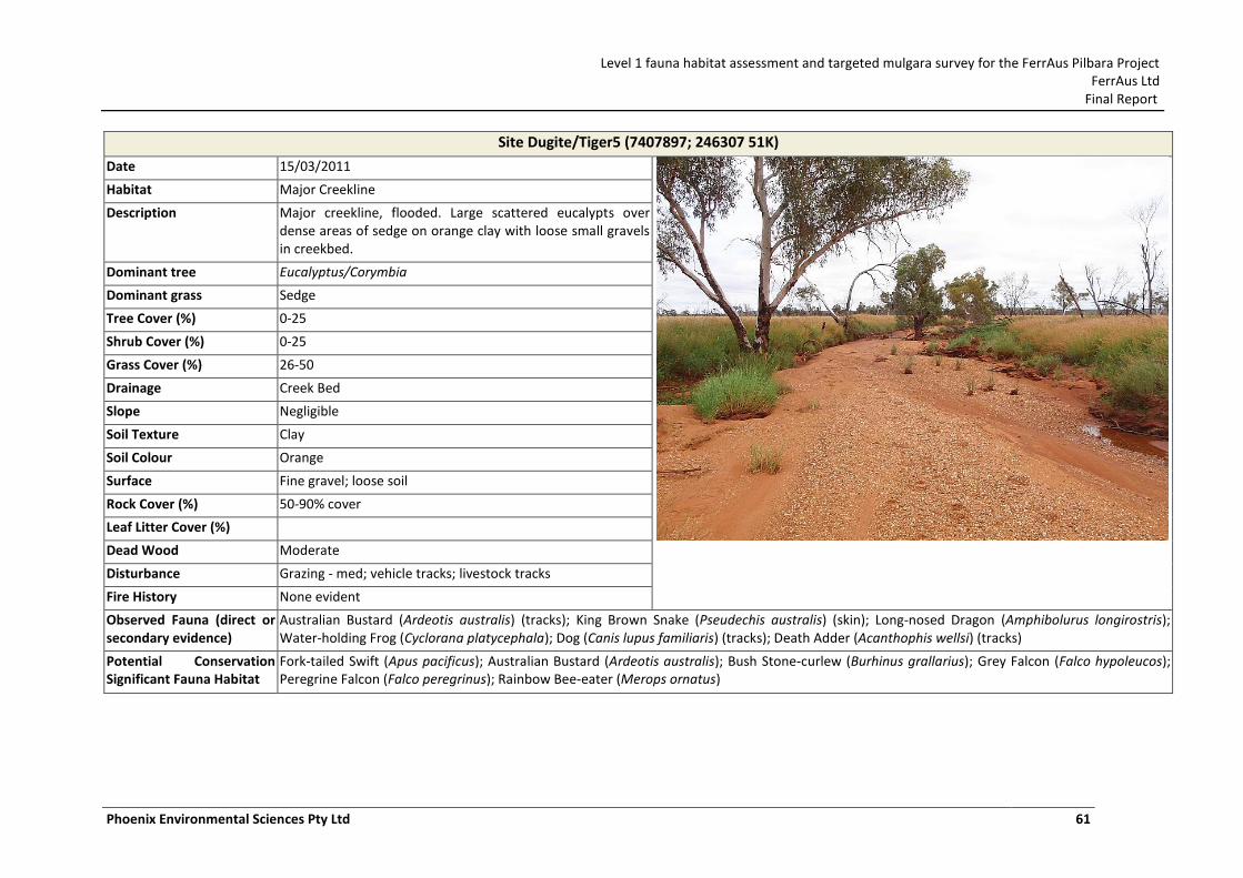
Level 1 fauna habitat assessment and targeted mulgara survey for the FerrAus Pilbara Project FerrAus Ltd
Final Report
Phoenix Environmental Sciences Pty Ltd 61
Site Dugite/Tiger5 (7407897; 246307 51K)
Date 15/03/2011
Habitat Major Creekline
Description Major creekline, flooded. Large scattered eucalypts over dense areas of sedge on orange clay with loose small gravels in creekbed.
Dominant tree Eucalyptus/Corymbia
Dominant grass Sedge
Tree Cover (%) 0-25
Shrub Cover (%) 0-25
Grass Cover (%) 26-50
Drainage Creek Bed
Slope Negligible
Soil Texture Clay
Soil Colour Orange
Surface Fine gravel; loose soil
Rock Cover (%) 50-90% cover
Leaf Litter Cover (%)
Dead Wood Moderate
Disturbance Grazing - med; vehicle tracks; livestock tracks
Fire History None evident
Observed Fauna (direct or secondary evidence)
Australian Bustard (Ardeotis australis) (tracks); King Brown Snake (Pseudechis australis) (skin); Long-nosed Dragon (Amphibolurus longirostris); Water-holding Frog (Cyclorana platycephala); Dog (Canis lupus familiaris) (tracks); Death Adder (Acanthophis wellsi) (tracks)
Potential Conservation Significant Fauna Habitat
Fork-tailed Swift (Apus pacificus); Australian Bustard (Ardeotis australis); Bush Stone-curlew (Burhinus grallarius); Grey Falcon (Falco hypoleucos); Peregrine Falcon (Falco peregrinus); Rainbow Bee-eater (Merops ornatus)
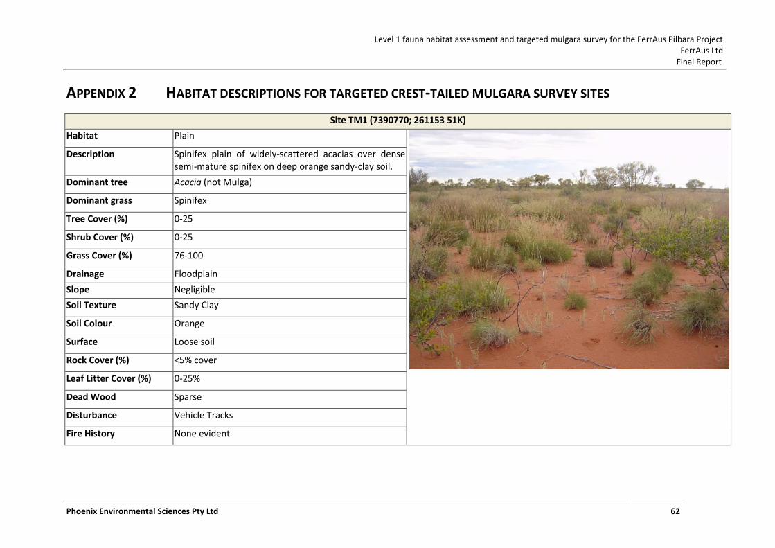
Level 1 fauna habitat assessment and targeted mulgara survey for the FerrAus Pilbara Project FerrAus Ltd
Final Report
Phoenix Environmental Sciences Pty Ltd 62
APPENDIX 2 HABITAT DESCRIPTIONS FOR TARGETED CREST-TAILED MULGARA SURVEY SITES
Site TM1 (7390770; 261153 51K)
Habitat Plain
Description Spinifex plain of widely-scattered acacias over dense semi-mature spinifex on deep orange sandy-clay soil.
Dominant tree Acacia (not Mulga)
Dominant grass Spinifex
Tree Cover (%) 0-25
Shrub Cover (%) 0-25
Grass Cover (%) 76-100
Drainage Floodplain
Slope Negligible
Soil Texture Sandy Clay
Soil Colour Orange
Surface Loose soil
Rock Cover (%) <5% cover
Leaf Litter Cover (%) 0-25%
Dead Wood Sparse
Disturbance Vehicle Tracks
Fire History None evident
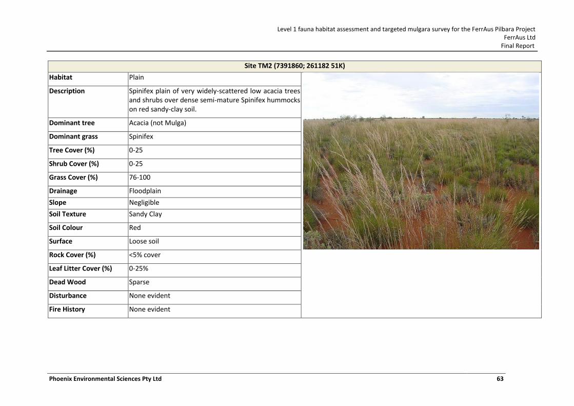
Level 1 fauna habitat assessment and targeted mulgara survey for the FerrAus Pilbara Project FerrAus Ltd
Final Report
Phoenix Environmental Sciences Pty Ltd 63
Site TM2 (7391860; 261182 51K)
Habitat Plain
Description Spinifex plain of very widely-scattered low acacia trees and shrubs over dense semi-mature Spinifex hummocks on red sandy-clay soil.
Dominant tree Acacia (not Mulga)
Dominant grass Spinifex
Tree Cover (%) 0-25
Shrub Cover (%) 0-25
Grass Cover (%) 76-100
Drainage Floodplain
Slope Negligible
Soil Texture Sandy Clay
Soil Colour Red
Surface Loose soil
Rock Cover (%) <5% cover
Leaf Litter Cover (%) 0-25%
Dead Wood Sparse
Disturbance None evident
Fire History None evident
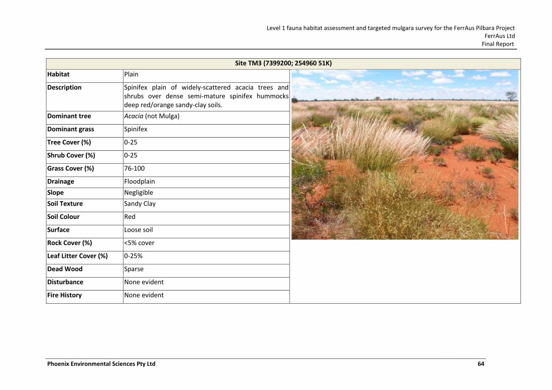
Level 1 fauna habitat assessment and targeted mulgara survey for the FerrAus Pilbara Project FerrAus Ltd
Final Report
Phoenix Environmental Sciences Pty Ltd 64
Site TM3 (7399200; 254960 51K)
Habitat Plain
Description Spinifex plain of widely-scattered acacia trees and shrubs over dense semi-mature spinifex hummocks deep red/orange sandy-clay soils.
Dominant tree Acacia (not Mulga)
Dominant grass Spinifex
Tree Cover (%) 0-25
Shrub Cover (%) 0-25
Grass Cover (%) 76-100
Drainage Floodplain
Slope Negligible
Soil Texture Sandy Clay
Soil Colour Red
Surface Loose soil
Rock Cover (%) <5% cover
Leaf Litter Cover (%) 0-25%
Dead Wood Sparse
Disturbance None evident
Fire History None evident
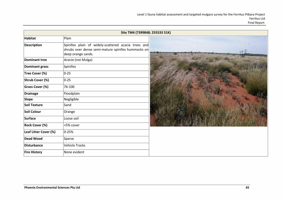
Level 1 fauna habitat assessment and targeted mulgara survey for the FerrAus Pilbara Project FerrAus Ltd
Final Report
Phoenix Environmental Sciences Pty Ltd 65
Site TM4 (7399848; 255533 51K)
Habitat Plain
Description Spinifex plain of widely-scattered acacia trees and shrubs over dense semi-mature spinifex hummocks on deep orange sands.
Dominant tree Acacia (not Mulga)
Dominant grass Spinifex
Tree Cover (%) 0-25
Shrub Cover (%) 0-25
Grass Cover (%) 76-100
Drainage Floodplain
Slope Negligible
Soil Texture Sand
Soil Colour Orange
Surface Loose soil
Rock Cover (%) <5% cover
Leaf Litter Cover (%) 0-25%
Dead Wood Sparse
Disturbance Vehicle Tracks
Fire History None evident
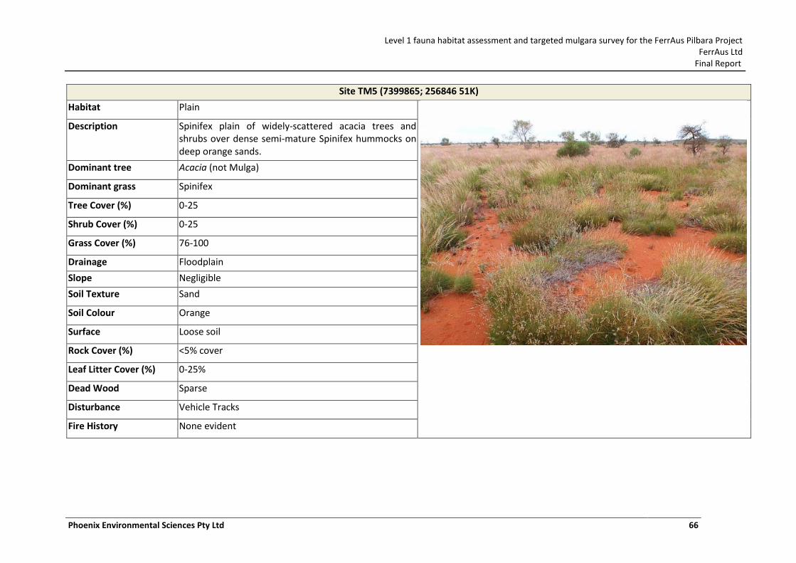
Level 1 fauna habitat assessment and targeted mulgara survey for the FerrAus Pilbara Project FerrAus Ltd
Final Report
Phoenix Environmental Sciences Pty Ltd 66
Site TM5 (7399865; 256846 51K)
Habitat Plain
Description Spinifex plain of widely-scattered acacia trees and shrubs over dense semi-mature Spinifex hummocks on deep orange sands.
Dominant tree Acacia (not Mulga)
Dominant grass Spinifex
Tree Cover (%) 0-25
Shrub Cover (%) 0-25
Grass Cover (%) 76-100
Drainage Floodplain
Slope Negligible
Soil Texture Sand
Soil Colour Orange
Surface Loose soil
Rock Cover (%) <5% cover
Leaf Litter Cover (%) 0-25%
Dead Wood Sparse
Disturbance Vehicle Tracks
Fire History None evident
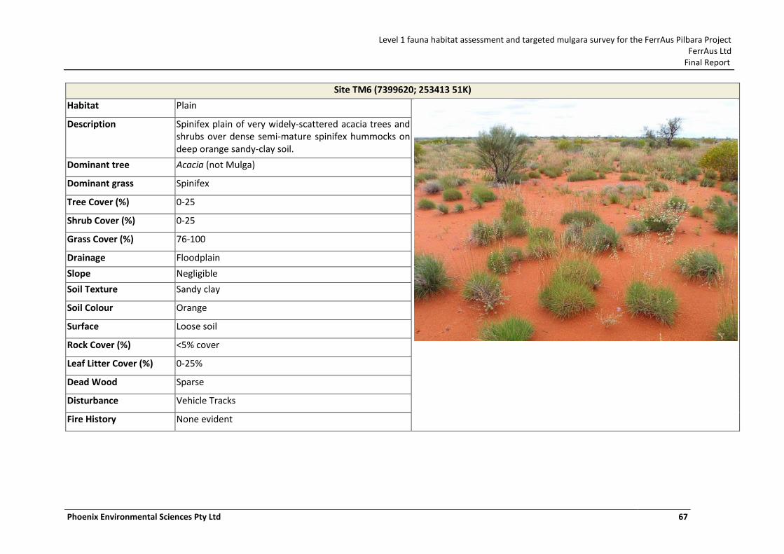
Level 1 fauna habitat assessment and targeted mulgara survey for the FerrAus Pilbara Project FerrAus Ltd
Final Report
Phoenix Environmental Sciences Pty Ltd 67
Site TM6 (7399620; 253413 51K)
Habitat Plain
Description Spinifex plain of very widely-scattered acacia trees and shrubs over dense semi-mature spinifex hummocks on deep orange sandy-clay soil.
Dominant tree Acacia (not Mulga)
Dominant grass Spinifex
Tree Cover (%) 0-25
Shrub Cover (%) 0-25
Grass Cover (%) 76-100
Drainage Floodplain
Slope Negligible
Soil Texture Sandy clay
Soil Colour Orange
Surface Loose soil
Rock Cover (%) <5% cover
Leaf Litter Cover (%) 0-25%
Dead Wood Sparse
Disturbance Vehicle Tracks
Fire History None evident
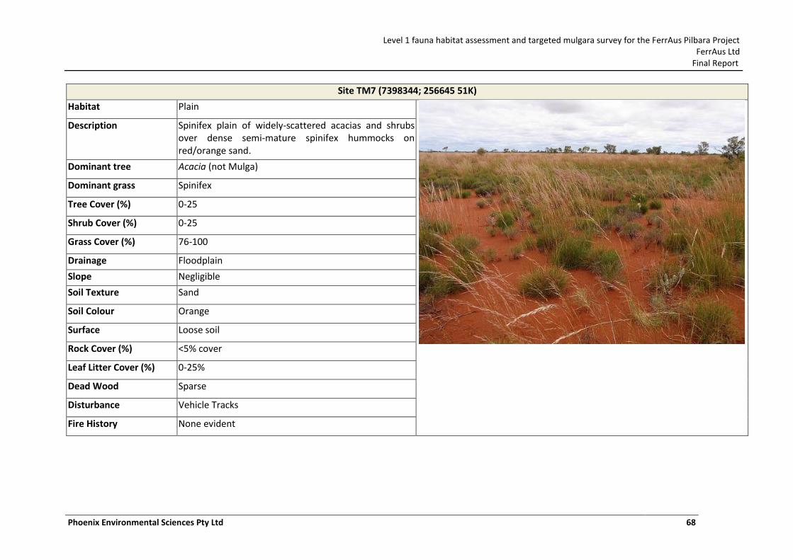
Level 1 fauna habitat assessment and targeted mulgara survey for the FerrAus Pilbara Project FerrAus Ltd
Final Report
Phoenix Environmental Sciences Pty Ltd 68
Site TM7 (7398344; 256645 51K)
Habitat Plain
Description Spinifex plain of widely-scattered acacias and shrubs over dense semi-mature spinifex hummocks on red/orange sand.
Dominant tree Acacia (not Mulga)
Dominant grass Spinifex
Tree Cover (%) 0-25
Shrub Cover (%) 0-25
Grass Cover (%) 76-100
Drainage Floodplain
Slope Negligible
Soil Texture Sand
Soil Colour Orange
Surface Loose soil
Rock Cover (%) <5% cover
Leaf Litter Cover (%) 0-25%
Dead Wood Sparse
Disturbance Vehicle Tracks
Fire History None evident
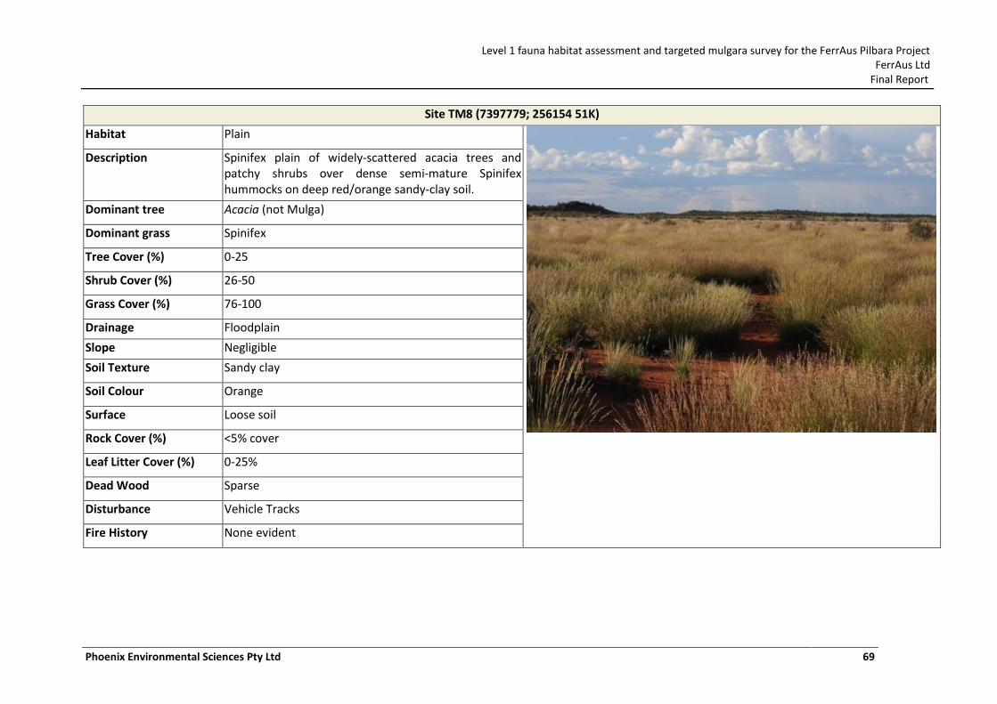
Level 1 fauna habitat assessment and targeted mulgara survey for the FerrAus Pilbara Project FerrAus Ltd
Final Report
Phoenix Environmental Sciences Pty Ltd 69
Site TM8 (7397779; 256154 51K)
Habitat Plain
Description Spinifex plain of widely-scattered acacia trees and patchy shrubs over dense semi-mature Spinifex hummocks on deep red/orange sandy-clay soil.
Dominant tree Acacia (not Mulga)
Dominant grass Spinifex
Tree Cover (%) 0-25
Shrub Cover (%) 26-50
Grass Cover (%) 76-100
Drainage Floodplain
Slope Negligible
Soil Texture Sandy clay
Soil Colour Orange
Surface Loose soil
Rock Cover (%) <5% cover
Leaf Litter Cover (%) 0-25%
Dead Wood Sparse
Disturbance Vehicle Tracks
Fire History None evident
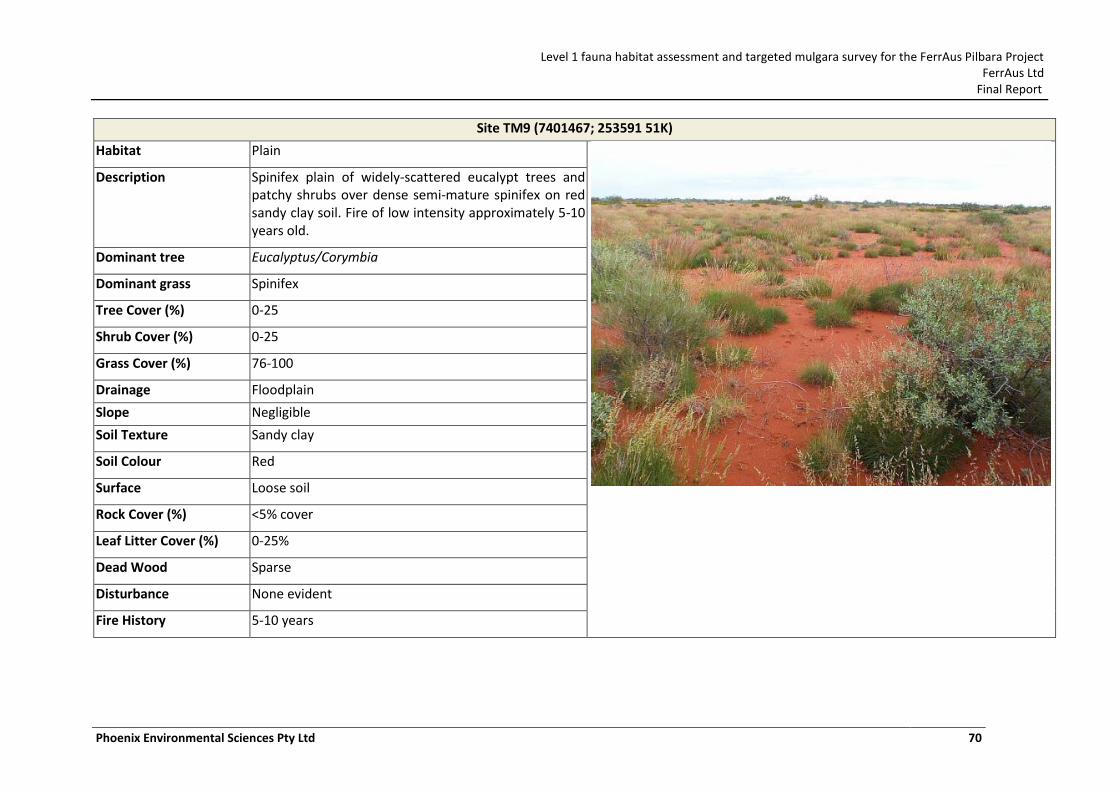
Level 1 fauna habitat assessment and targeted mulgara survey for the FerrAus Pilbara Project FerrAus Ltd
Final Report
Phoenix Environmental Sciences Pty Ltd 70
Site TM9 (7401467; 253591 51K)
Habitat Plain
Description Spinifex plain of widely-scattered eucalypt trees and patchy shrubs over dense semi-mature spinifex on red sandy clay soil. Fire of low intensity approximately 5-10 years old.
Dominant tree Eucalyptus/Corymbia
Dominant grass Spinifex
Tree Cover (%) 0-25
Shrub Cover (%) 0-25
Grass Cover (%) 76-100
Drainage Floodplain
Slope Negligible
Soil Texture Sandy clay
Soil Colour Red
Surface Loose soil
Rock Cover (%) <5% cover
Leaf Litter Cover (%) 0-25%
Dead Wood Sparse
Disturbance None evident
Fire History 5-10 years
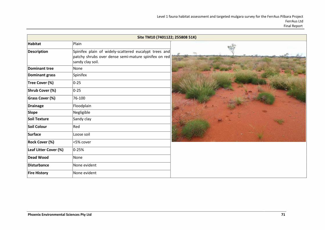
Level 1 fauna habitat assessment and targeted mulgara survey for the FerrAus Pilbara Project FerrAus Ltd
Final Report
Phoenix Environmental Sciences Pty Ltd 71
Site TM10 (7401122; 255808 51K)
Habitat Plain
Description Spinifex plain of widely-scattered eucalypt trees and patchy shrubs over dense semi-mature spinifex on red sandy clay soil.
Dominant tree None
Dominant grass Spinifex
Tree Cover (%) 0-25
Shrub Cover (%) 0-25
Grass Cover (%) 76-100
Drainage Floodplain
Slope Negligible
Soil Texture Sandy clay
Soil Colour Red
Surface Loose soil
Rock Cover (%) <5% cover
Leaf Litter Cover (%) 0-25%
Dead Wood None
Disturbance None evident
Fire History None evident
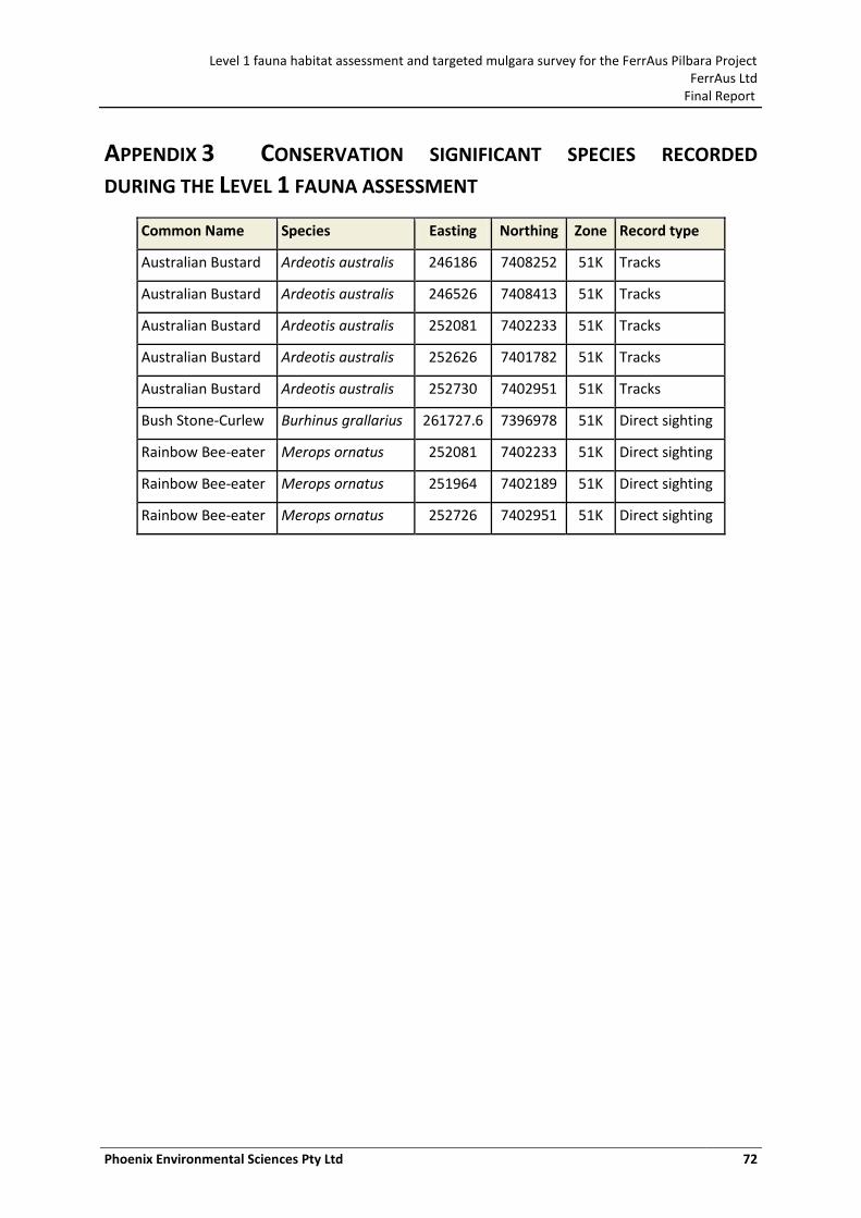
Level 1 fauna habitat assessment and targeted mulgara survey for the FerrAus Pilbara Project FerrAus Ltd
Final Report
Phoenix Environmental Sciences Pty Ltd 72
APPENDIX 3 CONSERVATION SIGNIFICANT SPECIES RECORDED
DURING THE LEVEL 1 FAUNA ASSESSMENT
Common Name Species Easting Northing Zone Record type
Australian Bustard Ardeotis australis 246186 7408252 51K Tracks
Australian Bustard Ardeotis australis 246526 7408413 51K Tracks
Australian Bustard Ardeotis australis 252081 7402233 51K Tracks
Australian Bustard Ardeotis australis 252626 7401782 51K Tracks
Australian Bustard Ardeotis australis 252730 7402951 51K Tracks
Bush Stone-Curlew Burhinus grallarius 261727.6 7396978 51K Direct sighting
Rainbow Bee-eater Merops ornatus 252081 7402233 51K Direct sighting
Rainbow Bee-eater Merops ornatus 251964 7402189 51K Direct sighting
Rainbow Bee-eater Merops ornatus 252726 7402951 51K Direct sighting
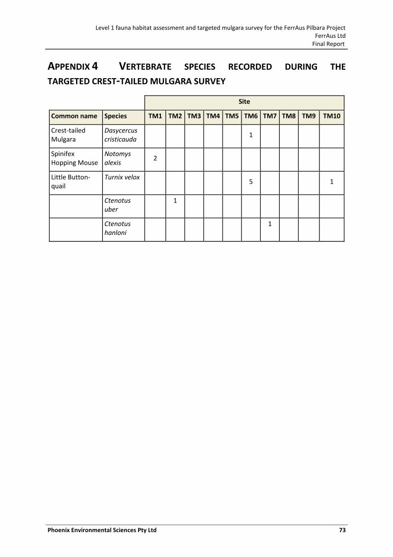
Level 1 fauna habitat assessment and targeted mulgara survey for the FerrAus Pilbara Project FerrAus Ltd
Final Report
Phoenix Environmental Sciences Pty Ltd 73
APPENDIX 4 VERTEBRATE SPECIES RECORDED DURING THE
TARGETED CREST-TAILED MULGARA SURVEY
Site
Common name Species TM1 TM2 TM3 TM4 TM5 TM6 TM7 TM8 TM9 TM10
Crest-tailed Mulgara
Dasycercus cristicauda
1
Spinifex Hopping Mouse
Notomys alexis
2
Little Button-quail
Turnix velox 5 1
Ctenotus uber
1
Ctenotus hanloni
1
Level 1 fauna habitat assessment and targeted mulgara survey for the FerrAus Pilbara Project FerrAus Ltd
Final Report
Phoenix Environmental Sciences Pty Ltd 74

Level 1 fauna habitat assessment and targeted mulgara survey for the FerrAus Pilbara Project FerrAus Ltd
Final Report
Phoenix Environmental Sciences Pty Ltd 75