Embed Size (px)
Citation preview
LEVEL 1 INSPECTION AND TESTING
WARRALILY ARMSTRONG CREEK
DEVELOPMENT – STAGE 54
Marshall, VIC
Newland Developers Pty Ltd
GEOTABTF08569AE-AN 14 June 2013
Coffey Geotechnics Pty Ltd ABN 93 056 929 483 126 Trenerry Crescent Abbotsford VIC 3067 Australia
LEVEL 1 INSPECTION AND TESTING
WARRALILY ARMSTRONG CREEK
DEVELOPMENT – STAGE 54
Marshall, VIC
Newland Developers Pty Ltd
GEOTABTF08569AE-AN 14 June 2013
CONTENTS
Coffey Geotechnics GEOTABTF08569AE-AN 14 June 2013
i
1 INTRODUCTION 1
2 PROJECT SUMMARY 1
3 SPECIFICATIONS / WORK INSTRUCTIONS 1
4 SUBGRADE ASSESSMENT 2
5 EARTHWORKS 2
6 FILL MATERIAL 2
7 FILL CONSTRUCTION 3
8 TESTING AND RESULTS 3
9 EXCLUSIONS 3
10 STATEMENT OF COMPLIANCE 4
Important Information About Your Coffey Report
Figures
Figure 1: Field Density Test Locations
Figure 2: Summary of Field Density Test Results
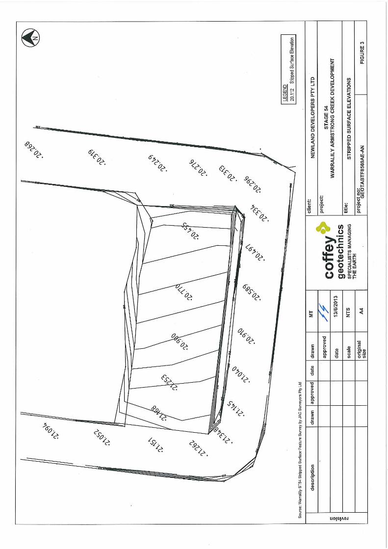
Figure 3: Stripped Surface Elevation
Appendices
Appendix A: Laboratory test Reports (3 pages)
Appendix B: Extract from Project Specifications (4 pages)

Level 1 Inspection and Testing
Warralily Armstrong Creek Development – Stage 54
Coffey Geotechnics GEOTABTF08569AE-AN 14 June 2013
1
1 INTRODUCTION
This report presents the results of the Level 1 Inspection and Testing for construction of the fill platforms
located within Stage 54 of Warralily Estate Armstrong Creek Development.
The works were commissioned by Martin O’Hanlon of Newland Developers Pty Ltd (Newland) by email
on 11 April 2013. The works were carried out in accordance with Coffey’s proposal
GEOTABTF08569AE-AK issued 27 March 2013.
2 PROJECT SUMMARY
It is understood that Newland requires the fill platforms within Stage 54 to be constructed under Level 1
Inspection and Testing undertaken by a Geotechnical Inspection and Testing Authority (GITA).
Level 1 Inspection and Testing, as defined in AS3798-2007 “Guidelines on Earthworks for Commercial
and Residential Development,” provides for full time inspection of the construction of controlled fill and
field and laboratory testing in accordance with AS1289 “Methods of Testing Soils for Engineering
Purposes”.
The Level 1 Inspection was undertaken by a Geotechnical Engineer from Coffey over a period of 7
working days from 16 April 2013 to 19 April 2013 and on 27, 28 and 29 May 2013.
The earthworks contractor for the project was Winslow. Coffey Information undertook the compaction
control testing of the fill material as part of the Level 1 Inspection and Testing process.
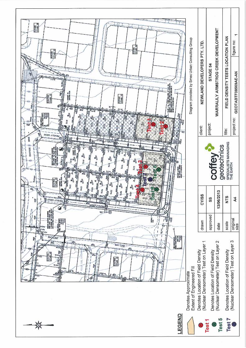
This report is applicable to fill placed by Winslow for the fill platforms for the proposed lots located within
Stage 54 of the Warralily Development as shown in Figure 1.
This report does not include fill other than where mentioned in this report or any other fill that may be
placed during this period or subsequent periods at or surrounding the subject site. Excluded works
such as trench backfill, foot paths, landscaping fill or topsoil are noted in section 9 of this report.
3 SPECIFICATIONS / WORK INSTRUCTIONS
The specification for the project was prepared by SMEC Australia Pty Ltd (SMEC) for Armstrong Creek
Development Corporation Pty Ltd under reference number 0557ESB-24. Extracts of the specification
were provided to Coffey in an email sent by Shane McGlynn from SMEC on 5 October 2012. The
extract of the specified requirements is provided in Appendix B and a short summary is provided below:
- All filling in excess of 300mm depth within the building envelope of allotments shall be
undertaken to specifications satisfying the requirements of AS 3798-1996 “Guidelines on
Earthworks for Commercial and Residential Development”.
- All such filling works shall be undertaken with supervision to the standard detailed as “Level 1
Inspection and Testing” in AS 3798-2007, such that the supervisor will issue a notice detailing
that the works comply with the specifications and drawings.
- Material to be used for fill construction shall satisfy the requirements of AS 3798-2007
“Guidelines on Earthworks for Commercial and Residential Developments”.
- Fill to be compacted in near horizontal layers not exceeding 250mm loose thickness
Level 1 Inspection and Testing
Warralily Armstrong Creek Development – Stage 54 (Rev 1)
Coffey Geotechnics GEOTABTF08569AE-AN 14 June 2013 (revised 25 June 2013)
2
- Compaction to achieve a dry density ratio of at least 95% Standard; and
- Moisture content of the fill material is to be within ±3% of the Standard optimum Moisture
Content (SOMC).
4 SUBGRADE ASSESSMENT
The subgrade was assessed by Coffey following the topsoil removal and before any fill was placed.
The subgrade assessment was conducted on 16 April 2013.
The exposed subgrade was rolled by a 20 tonne compactor. The soils exposed at the subgrade level
comprised natural clay silts and silty clays. No soft spots were observed during the subgrade
assessment.
5 EARTHWORKS
The earthworks for this project included stripping of topsoil, removing of tree roots, proof rolling the
subgrade and placement and compaction of fill to construct engineered platforms.
Winslow’s appointed surveyor conducted a survey of the subgrade level following the topsoil removal
April 2013. The surveyed level at the subgrade varied from RL 20.455m in the south eastern areas to
RL 21.168m in the south western areas of the site. The survey plan of the stripped surface is attached
in Figure 3.
The completed fill platform surface was not surveyed by the contractor. To ascertain that fill layers were
tested at layers not exceeding 250mm thickness, total fill layer thicknesses were taken as the difference
between final levels on design plans and the survey of the subgrade level. This is only valid if the sum
of topsoil placed and actual fill levels coincided with the design plans. The topsoil layer to finished level
is assumed to be 150mm thick. The total fill layer thicknesses were then compared to the number of
layers tested.
Based on the survey of subgrade level and design plans, it is understood the average fill thickness is as
follows:
- Approximately 250mm on lots 5425 to 5427 which comprised 1 layer of engineered fill;
- Up to approximately 750mm on lots 5408 to 5412 which comprised up to 3 layers of engineered
fill.
6 FILL MATERIAL
The fill used for construction of the platforms consisted of imported soils from a golf course
redevelopment site which is located between Thompson Rd and Midland Highway in Geelong.
Newland have provided an environmental soil assessment report conducted on the source soils
confirming no contaminated materials were present within the stockpiles arranged for the proposed fill
within Stage 54.
An Associate Geotechnician from Coffey visited the Golf Course source site on 12 April 2013 to visually
assess the stockpiles of the material prior to it being imported to the project. The stockpiled soils
comprised sandy clay and silty clay. No organic matter or oversize material was observed at the time of
the stockpiles assessment.
Level 1 Inspection and Testing
Warralily Armstrong Creek Development – Stage 54 (Rev 1)
Coffey Geotechnics GEOTABTF08569AE-AN 14 June 2013 (revised 25 June 2013)
3
The material was imported to the site over the course of the works by road trucks. The material was
visually assessed by the Level 1 Inspector at the time it was dumped on site and during its spreading
and placement. No organic or oversize materials were observed within the imported soils.
7 FILL CONSTRUCTION
The fill material was moisture conditioned during placement and prior to the placement while it was
stockpiled.
The material was placed generally in loose layers varying in thickness from 200mm to 300mm.
Compacted layers achieved approximately 150mm to 250mm in thickness.
Material was spread and compacted by a CAT 815F 20 tonne compactor. A 12 tonne water truck was
used for moisture conditioning the material during placement.
As can be seen on Figure 1, fill placed on Stage 54 can be divided into two areas, one pad in the east
and one pad in the south. One layer with thickness of approximately 250mm was placed and
compacted across the eastern pad. Up to three layers with thickness of fill varying from 250mm to
750mm were placed on the southern pad
Coffey’s level 1 Inspector was on site on a full time basis during the placement, compaction and testing
of the fill.
8 TESTING AND RESULTS
Field density testing was undertaken progressively on the compacted fill at a frequency of a minimum of
1 test per layer per material type per 2500m² as required for Type 1 Earthworks (Large Scale
operations) as defined in Table 8.1 of the AS 3798-2007.
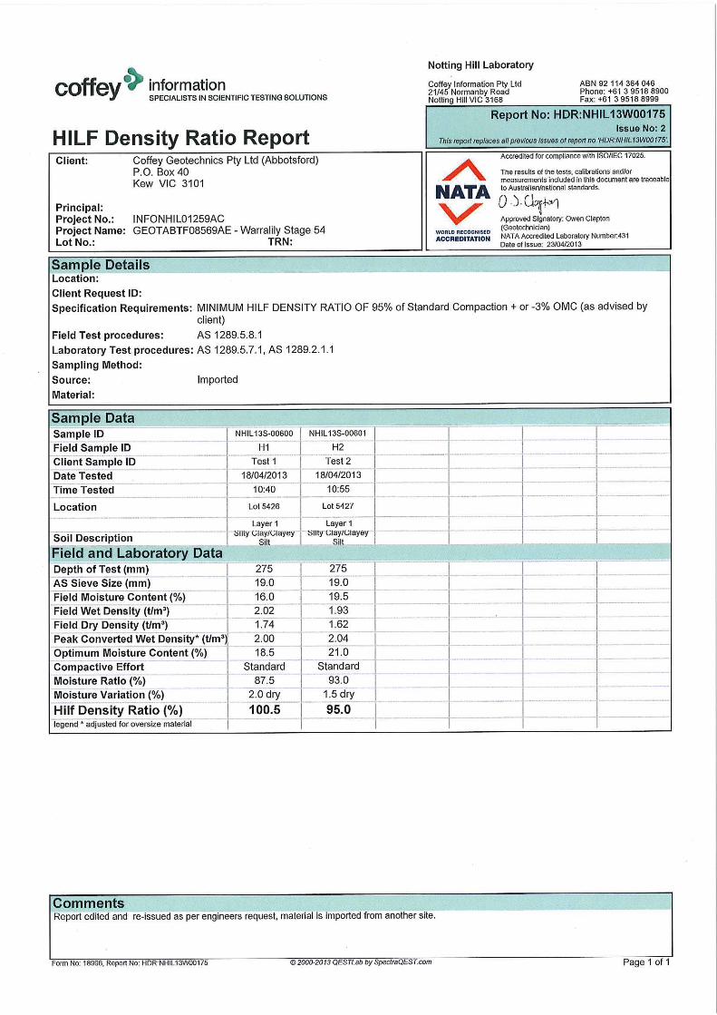
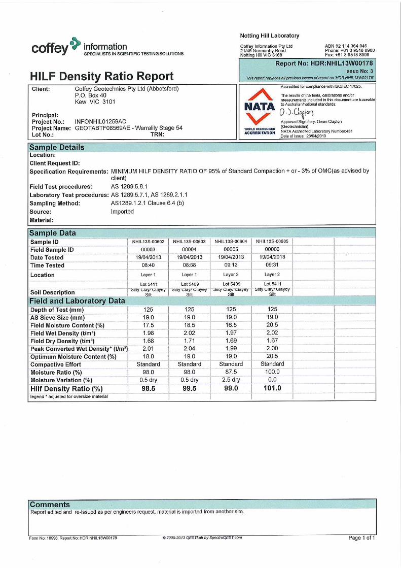
The field density testing was conducted by Coffey Information and all laboratory testing was performed
in their NATA accredited laboratory in Notting Hill. A Hilf compaction test was performed for each field
density test.
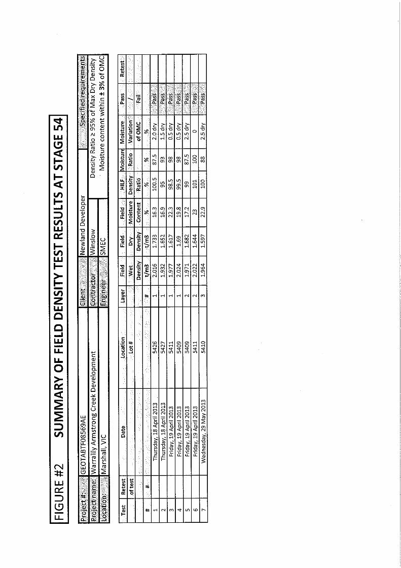
A total of 7 field density tests were performed during the earthworks. All of the test results met the
specified criteria of 95% Standard compaction and moisture variation of 3% of the Optimum Moisture
Content (OMC).
The location of the 7 field density tests is shown in Figure 1. A summary of the test results obtained
from the field density testing within Stage 54 fill platforms is provided in a table attached as Figure 2.
The laboratory test reports of the field density tests are presented in Appendix A.
9 EXCLUSIONS
Trenches were excavated and backfilled on site for the installation of underground services such as
sewers, electrical conduits, water mains etc. Footpaths in front of the lots were also observed to be
excavated and filled during and after the Level 1 GITA services conducted by Coffey. Uncontrolled fill
and topsoil may have been placed as part of the landscaping of the site following the completion of the
engineered fill construction.
Coffey was not involved in monitoring and testing these works and as such are not included in the Level
1 report.
Coffey Geotechnics Pty Ltd ABN 93 056 929 483
As a client of Coffey you should know that site subsurface conditions cause more constructionproblems than any other factor. These notes have been prepared by Coffey to help youinterpret and understand the limitations of your report.
Your report is based on project specific criteria
Your report has been developed on the basis of yourunique project specific requirements as understoodby Coffey and applies only to the site investigated.Project criteria typically include the general nature ofthe project; its size and configuration; the location ofany structures on the site; other site improvements;the presence of underground utilities; and the additionalrisk imposed by scope-of-service limitations imposedby the client. Your report should not be used if thereare any changes to the project without first askingCoffey to assess how factors that changed subsequentto the date of the report affect the report'srecommendations. Coffey cannot accept responsibilityfor problems that may occur due to changed factorsif they are not consulted.
Subsurface conditions can change
Subsurface conditions are created by natural processesand the activity of man. For example, water levelscan vary with time, fill may be placed on a site andpollutants may migrate with time. Because a reportis based on conditions which existed at the time ofsubsurface exploration, decisions should not be basedon a report whose adequacy may have been affectedby time. Consult Coffey to be advised how time mayhave impacted on the project.
Interpretation of factual data
Site assessment identifies actual subsurface conditionsonly at those points where samples are taken andwhen they are taken. Data derived from literatureand external data source review, sampling and subsequent laboratory testing are interpreted bygeologists, engineers or scientists to provide anopinion about overall site conditions, their likelyimpact on the proposed development and recommendedactions. Actual conditions may differ from those inferredto exist, because no professional, no matter howqualified, can reveal what is hidden by
Your report will only givepreliminary recommendationsYour report is based on the assumption that thesite conditions as revealed through selectivepoint sampling are indicative of actual conditionsthroughout an area. This assumption cannot besubstantiated until project implementation hascommenced and therefore your report recommendationscan only be regarded as preliminary. Only Coffey,who prepared the report, is fully familiar with thebackground information needed to assess whetheror not the report's recommendations are valid andwhether or not changes should be considered asthe project develops. If another party undertakesthe implementation of the recommendations of thisreport there is a risk that the report will be misinterpretedand Coffey cannot be held responsible for suchmisinterpretation.
earth, rock and time. The actual interface betweenmaterials may be far more gradual or abrupt thanassumed based on the facts obtained. Nothing canbe done to change the actual site conditions whichexist, but steps can be taken to reduce the impact ofunexpected conditions. For this reason, ownersshould retain the services of Coffey through thedevelopment stage, to identify variances, conductadditional tests if required, and recommend solutionsto problems encountered on site.
Your report is prepared forspecific purposes and personsTo avoid misuse of the information contained in yourreport it is recommended that you confer with Coffeybefore passing your report on to another party whomay not be familiar with the background and thepurpose of the report. Your report should not beapplied to any project other than that originallyspecified at the time the report was issued.
Important information about your Coffey Report
* For further information on this aspect reference should bemade to "Guidelines for the Provision of Geotechnicalinformation in Construction Contracts" published by theInstitution of Engineers Australia, National headquarters,Canberra, 1987.
Interpretation by other design professionals
Costly problems can occur when other design professionals develop their plans based on misinterpretationsof a report. To help avoid misinterpretations, retainCoffey to work with other project design professionalswho are affected by the report. Have Coffey explainthe report implications to design professionals affectedby them and then review plans and specificationsproduced to see how they incorporate the reportfindings.
Data should not be separated from the report*
The report as a whole presents the findings of the siteassessment and the report should not be copied inpart or altered in any way.
Logs, figures, drawings, etc. are customarily includedin our reports and are developed by scientists,engineers or geologists based on their interpretationof field logs (assembled by field personnel) andlaboratory evaluation of field samples. These logs etc.should not under any circumstances be redrawn forinclusion in other documents or separated from thereport in any way.
Geoenvironmental concerns are not at issue
Your report is not likely to relate any findings,conclusions, or recommendations about the potentialfor hazardous materials existing at the site unlessspecifically required to do so by the client. Specialistequipment, techniques, and personnel are used toperform a geoenvironmental assessment.Contamination can create major health, safety andenvironmental risks. If you have no information aboutthe potential for your site to be contaminated or createan environmental hazard, you are advised to contactCoffey for information relating to geoenvironmentalissues.
Rely on Coffey for additional assistance
Coffey is familiar with a variety of techniques andapproaches that can be used to help reduce risks forall parties to a project, from design to construction. Itis common that not all approaches will be necessarilydealt with in your site assessment report due toconcepts proposed at that time. As the projectprogresses through design towards construction,speak with Coffey to develop alternative approachesto problems that may be of genuine benefit both intime and cost.
Responsibility
Reporting relies on interpretation of factual informationbased on judgement and opinion and has a level ofuncertainty attached to it, which is far less exact thanthe design disciplines. This has often resulted in claimsbeing lodged against consultants, which are unfounded.To help prevent this problem, a number of clauseshave been developed for use in contracts, reports andother documents. Responsibility clauses do not transferappropriate liabilities from Coffey to other parties butare included to identify where Coffey's responsibilitiesbegin and end. Their use is intended to help all partiesinvolved to recognise their individual responsibilities.Read all documents from Coffey closely and do nothesitate to ask any questions you may have.
Coffey Geotechnics Pty Ltd ABN 93 056 929 483
Important information about your Coffey Report
Coffey Geotechnics GEOTABTF08569AE-AN 14 June 2013
Figures Figure 1: Field Density Test Locations
Figure 2: Summary of Field Density Test Results
Figure 3: Stripped surface elevation by JAC surveyors

Coffey Geotechnics GEOTABTF08569AE-AN 14 June 2013
Appendix A: Laboratory test reports (3 pages)


Coffey Geotechnics GEOTABTF08569AE-AN 14 June 2013
Appendix B: Extract from project specifications (4 pages)


![[XLS] · Web viewFoglio3 Foglio2 Foglio1 VW NEW BEETLE 2000 8V 115CV 327-2.075 4F1E 935-9.560 2D49 262-2.141 AC0F 721-8.157 89EA 936-0.255 D910 047-6.873 C881 605-1.921 619-3.067](https://img.pdfslide.net/doc/110x75/5c05092509d3f2183a8cd3f2/xls-web-viewfoglio3-foglio2-foglio1-vw-new-beetle-2000-8v-115cv-327-2075.jpg)