Embed Size (px)
Citation preview

US Army Corps of EngineersBUILDING STRONG®
Kristian Mickelson, PE
Seattle District09 March 2016
Libby Dam Information BriefColumbia Basin Regional Advisory Committee and
CRT Local Governments’ CommitteeKootenay System Workshop

BUILDING STRONG®
Executive SummaryPurpose: Inform the Kootenay Basin stakeholders about multi-
purpose Libby Dam operations in the context of an interstate & international watershed
BLUF: Libby Dam & Koocanusa Reservoir fulfill 5-purposes (hydro, flood risk, fish/wildlife, recreation, navigation) purposes while meeting environmental requirements in the international Kootenai River watershed of the upper Columbia Basin
Key points:1. Complex – only Corps dam w/upstream & downstream
international impacts2. CRT & IJC framework drive international interaction3. Significant Endangered Species Act considerations (NOAA BiOp
= salmon & steelhead; USFWS BiOp = sturgeon & bull trout)
2

BUILDING STRONG®
Libby Dam
3
Columbia Basin Map

BUILDING STRONG®
Upstream/Lake Koocanusa US
► Lake Recreation• Access for boats – Lake is too low• Marina Beaches inundated if
reservoir is too high (2459 ft)
► Air Quality – Dust if lake is low Canada
► Lake Recreation• Max elevation of Libby Dam is 2459
ft per Columbia River Treaty• Access for boats – Lake is too low
Lake does not reach Canada until elevation 2420 ft
• Beaches inundates if reservoir is at 2459 ft
► Air Quality – Dust if lake is low
International Interests & ConcernsDownstream/Border &
Kootenay Lake US
► Flood Control (Bonners Ferry,ID)
► Fishery – ESA listed species► Levee sloughing and saturation► Seepage of farmlands in
Kootenai Flats (Northern Idaho) Canada
► Kootenay Lake• Elevation (1755 ft) – Flood Control• Power generation – Flows in winter
► Levee slough and saturation► Farmland Seepage
4
BUILDING STRONG®
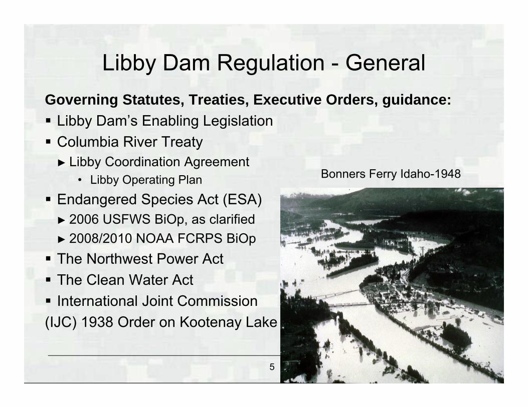
Governing Statutes, Treaties, Executive Orders, guidance: Libby Dam’s Enabling Legislation Columbia River Treaty
► Libby Coordination Agreement• Libby Operating Plan
Endangered Species Act (ESA)► 2006 USFWS BiOp, as clarified► 2008/2010 NOAA FCRPS BiOp The Northwest Power Act The Clean Water Act International Joint Commission (IJC) 1938 Order on Kootenay Lake
Libby Dam Regulation - General
Bonners Ferry Idaho-1948
5

BUILDING STRONG®
Libby Dam Water Management in Kootenai Watershed
Basin Characteristic – Variability Large: 9K mi^2 above & 10K mi^2 below dam Elevation from 2,500 to 12,000 ft Large monsoonal events in June/July Kootenay Lake creates a backwater into
Northern IdahoLibby provides local & system control Max flood control draft = 4.98 MAF (El 2287 ft) Koocanusa full pool is El 2459 ft Local Flood Control Point is Bonners Ferry, ID System Flood Control for Portland & Lower
Columbia developed areas
6

BUILDING STRONG®
VARQ FC (Variable Flow Flood Control) is the preferred flood control procedure, operated to the “Standard” FC pre-2003► Improves the chances of refill► Provides more normative flow
Draws the reservoir down less in the winter and requires more water out in the springtime
Adopted as the permanent flood control procedure - June 2008
Libby Flood Control Operations
Libby Dam Outflows - comparison of VARQ and Standard
0
5,000
10,000
15,000
20,000
25,000
30,000
1-Jan 1-Feb 1-Mar 1-Apr 1-May 1-Jun 1-Jul
Out
flow
(cfs
)
Standard
VARQ
Lake Koocanusa Elev - comparison of VARQ and Standard
2,320
2,340
2,360
2,380
2,400
2,420
2,440
2,460
1-Jan 1-Feb 1-Mar 1-Apr 1-May 1-Jun 1-Jul
elev
(fee
t)
VARQ
Standard

BUILDING STRONG®
Kootenay Lake and International Joint Commission (IJC)
Kootenay Lake Order relates to Corra Linn Dam, owned by FortisBC
Board of Control provides oversight of Corra Linn Dam► Board Members from both the US and Canada
Compensates Idaho farmers for effects of higher groundwater The Order allows FortisBC to store water in the lake, but
specifies a “lowering” formula for the freshet.Kootenay Lake Hydrograph
1,737
1,739
1,741
1,743
1,745
1,747
1,749
J F M A M J J A S O N D
Month
Stag
e (fe
et)
Rule Curve
Queens Bay
Nelson
2005 International Kootenay Lake Board of Control
2005-04-23Commencement of spring rise
Libby Dam reduced releases in both 2011 and 2012 to help with Queens Bay stage on Kootenay Lake
8

BUILDING STRONG®
Biological Opinions 2006 USFWS BiOp, as clarified 2008/2010 NOAA FCRPS BiOpOperational Requirements Bull trout minimum flows
► Provides higher required minimum flows from May 15th-Sept 30th
Sturgeon operations► Dedicated release to proved a pulse in the later spring -
early summer Salmon target
► 10 – 20 ft from full by 30 September► Required target to help with fish passage on the mainstem
of the Columbia River
Libby Dam Regulation – BiOp
9

BUILDING STRONG®
“Average” Libby Water Year, 5.885 MAF Apr-Aug Volume
0
10000
20000
30000
40000
50000
60000
70000
80000
1-Oct 31-Oct 30-Nov 30-Dec 29-Jan 28-Feb 30-Mar 29-Apr 29-May 28-Jun 28-Jul 27-Aug 26-Sep
Date
Flow
(cfs
)
2250.02260.02270.02280.02290.02300.02310.02320.02330.02340.02350.02360.02370.02380.02390.02400.02410.02420.02430.02440.02450.02460.0
Elev
atio
n (ft
)
Inflow Regulated Outflow URC Elev Regulated Elevation
Draw dow n Period from Nov through SoR
VarQ Sturgeon
Draft to 2449 ft Sept 30th

BUILDING STRONG®
Large Water Year (2012), 9.195 MAF Apr-Aug Volume
11

BUILDING STRONG®
Small Water Year (2015), 4.225 MAF Apr-Aug Volume
2330
2340
2350
2360
2370
2380
2390
2400
2410
2420
2430
2440
2450
2460
0
10
20
30
40
50
60
70
80
90
100
110
120
130
1-Oct 1-Nov 1-Dec 1-Jan 1-Feb 1-Mar 1-Apr 1-May 1-Jun 1-Jul 1-Aug 1-Sep
Elev
atio
n (ft
)
Flow
(kcf
s)
Date
Observed Outflow
Observed Inflow
Observed Forebay
Max Elevation of 2444.07 ft. on 7/16
Min Elevation of 2409.71 ft. on Feb 4
9/30 Elevation of 2440.24 ft.
12

BUILDING STRONG®
Libby Dam Effects on Kootenai River
Ecosystem
Reversed Hydrograph
Kootenai River TemperaturesPre- and Post-Libby Dam
0
5
10
15
20
1/1 2/1 3/1 4/1 5/1 6/1 7/1 8/1 9/1 10/1
11/1
12/1
DateTe
mpe
ratu
re (C
)Copeland '67-'72 Bonners Ferry '93-'03
Warmer Winter
Temperatures
Cooler Spring Temperatures
Pre- and Post-Libby Dam Hydrograph
Pre- and Post-Libby Dam Thermograph
13

BUILDING STRONG®
River and Lake Regulation Effects in Kootenai River at Bonners Ferry, Idaho
Regulation of the Kootenai River at Libby Dam and of Kootenay Lake at Corra Linn Dam alters depth and location of Kootenay Lake / Kootenai River backwater interface at Bonners Ferry, Idaho.
Sturgeon now spawn in deep water over sand and silty substrates – no survival of eggs.
Low Gradient / Deposition / Fine Sediments
High Gradient / Scour / Coarse Sediments
14

BUILDING STRONG®
Kootenai River White Sturgeon Recovery Team
15

BUILDING STRONG®
Sturgeon / Ecosystem Habitat
EnhancementCenter for Biological Diversity Lawsuit Settlement Agreement
Clarified USFWS BiOp RPA’s
Corps and BPA to fully support KTOI Ecosystem Habitat Restoration Projects
16

BUILDING STRONG®
Conclusion Take Aways:
► Libby Dam provides flood control, hydropower, and recreation for the mutual benefit of the USA and Canada
►Endangered Species Act considerations complicate Libby Dam’s operation
► Libby Dam is a key component in the Columbia River Treaty and operates within the framework of the International Joint Commission Order for Kootenay Lake
Questions: ???
17

BUILDING STRONG®
Trivia Does Libby change operations of Kootenay Lake?
►Yes, the Corps worked closely with BC Hydro in both 2011 and 2012 to minimize lake levels where possible
Questions: ???
18

BUILDING STRONG®
Questions: ???
Photo y Arnold C (User:Buchanan-Hermit) - Own work, Attribution, https://commons.wikimedia.org/w/index.php?curid=1107740
19