Embed Size (px)
Citation preview
LICENCE RELINQUISHMENT REPORT:
UKCS LICENCE: P.1757
ConocoPhillips UK LTD.
November, 2012
Relinquishment Report for Licence: P.1757 (Blocks 7/30 and 8/26) 1. Licence Information Licence Number P.1757 Licence Round 26th Round (10 January 2011) License Type Traditional Block Numbers 07/30; 08/26 Operator / Partner (%) ConocoPhillips (U.K) Ltd. (100%) Work Programme Shoot 600Km of 2D seismic data
Obtain 100Km of 2D seismic data Drill-or-drop. One well to 2100m or 50m beneath
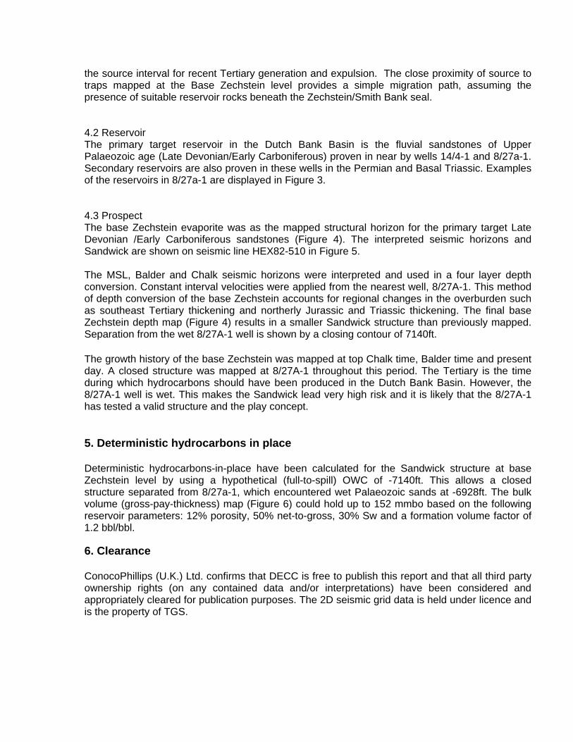
Base Zechstein, whichever is the shallower 2. Licence Synopsis Licence P.1757 was awarded to ConocoPhillips (U.K.) Ltd. on 10th January 2011 (Figure 1). The terms of the Licence included a firm commitment to shoot 600km of 2D seismic data and obtain 100Km of 2D seismic data, with a drill-or-drop commitment to drill one well to 2100m or 50m beneath the base Zechstein, whichever is the shallower or elect to allow the licence to automatically cease. The firm work programme commitment has been fulfilled. On the basis of the technical evaluation of the new data, ConocoPhillips (U.K.) Ltd. elected to relinquish the two blocks without exploration drilling. 3. Exploration Activities There are no exploration wells in either block of this licence. In the initial evaluation of the P.1757 area a large Carboniferous / Devonian lead called Sandwick was identified, straddling blocks 7/30 and 8/26. The prospect mapping was based on limited 2D seismic coverage. The work programme carried out on the basis of the 26th Round award was designed to infill the existing 2D database in order to better define the Sandwick lead and the surrounding structures. A total of 783 km of new 2010 and 2011 2D acquisition was licensed from TGS-NOPEC. An additional 2 NSR09 lines (161km) were licensed and all new and existing TGS lines were reprocessed including one vintage line HEX82-510 totaling 1343km. The full programme is shown in table 1. Figure 2 shows the 2D seismic coverage, including the recently acquired data. The main objective of this programme was to achieve a higher resolution image of the Leads at and below the Base
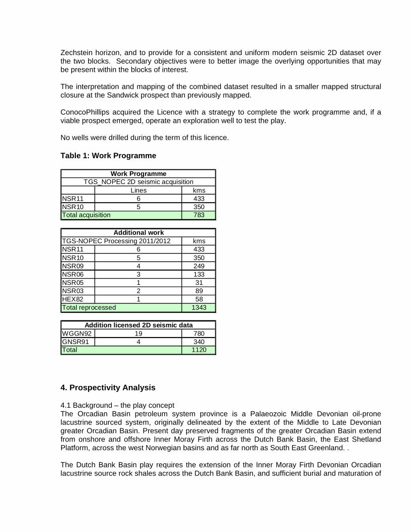
Zechstein horizon, and to provide for a consistent and uniform modern seismic 2D dataset over the two blocks. Secondary objectives were to better image the overlying opportunities that may be present within the blocks of interest. The interpretation and mapping of the combined dataset resulted in a smaller mapped structural closure at the Sandwick prospect than previously mapped. ConocoPhillips acquired the Licence with a strategy to complete the work programme and, if a viable prospect emerged, operate an exploration well to test the play. No wells were drilled during the term of this licence. Table 1: Work Programme
Lines kmsNSR11 6 433NSR10 5 350
783
kmsNSR11 6 433NSR10 5 350NSR09 4 249NSR06 3 133NSR05 1 31NSR03 2 89HEX82 1 58
1343
WGGN92 19 780GNSR91 4 340
1120Total
TGS_NOPEC 2D seismic acquisition
TGS-NOPEC Processing 2011/2012
Work Programme
Total acquisition
Additional work
Total reprocessed
Addition licensed 2D seismic data
4. Prospectivity Analysis 4.1 Background – the play concept The Orcadian Basin petroleum system province is a Palaeozoic Middle Devonian oil-prone lacustrine sourced system, originally delineated by the extent of the Middle to Late Devonian greater Orcadian Basin. Present day preserved fragments of the greater Orcadian Basin extend from onshore and offshore Inner Moray Firth across the Dutch Bank Basin, the East Shetland Platform, across the west Norwegian basins and as far north as South East Greenland. . The Dutch Bank Basin play requires the extension of the Inner Moray Firth Devonian Orcadian lacustrine source rock shales across the Dutch Bank Basin, and sufficient burial and maturation of
the source interval for recent Tertiary generation and expulsion. The close proximity of source to traps mapped at the Base Zechstein level provides a simple migration path, assuming the presence of suitable reservoir rocks beneath the Zechstein/Smith Bank seal. 4.2 Reservoir The primary target reservoir in the Dutch Bank Basin is the fluvial sandstones of Upper Palaeozoic age (Late Devonian/Early Carboniferous) proven in near by wells 14/4-1 and 8/27a-1. Secondary reservoirs are also proven in these wells in the Permian and Basal Triassic. Examples of the reservoirs in 8/27a-1 are displayed in Figure 3. 4.3 Prospect The base Zechstein evaporite was as the mapped structural horizon for the primary target Late Devonian /Early Carboniferous sandstones (Figure 4). The interpreted seismic horizons and Sandwick are shown on seismic line HEX82-510 in Figure 5. The MSL, Balder and Chalk seismic horizons were interpreted and used in a four layer depth conversion. Constant interval velocities were applied from the nearest well, 8/27A-1. This method of depth conversion of the base Zechstein accounts for regional changes in the overburden such as southeast Tertiary thickening and northerly Jurassic and Triassic thickening. The final base Zechstein depth map (Figure 4) results in a smaller Sandwick structure than previously mapped. Separation from the wet 8/27A-1 well is shown by a closing contour of 7140ft. The growth history of the base Zechstein was mapped at top Chalk time, Balder time and present day. A closed structure was mapped at 8/27A-1 throughout this period. The Tertiary is the time during which hydrocarbons should have been produced in the Dutch Bank Basin. However, the 8/27A-1 well is wet. This makes the Sandwick lead very high risk and it is likely that the 8/27A-1 has tested a valid structure and the play concept. 5. Deterministic hydrocarbons in place Deterministic hydrocarbons-in-place have been calculated for the Sandwick structure at base Zechstein level by using a hypothetical (full-to-spill) OWC of -7140ft. This allows a closed structure separated from 8/27a-1, which encountered wet Palaeozoic sands at -6928ft. The bulk volume (gross-pay-thickness) map (Figure 6) could hold up to 152 mmbo based on the following reservoir parameters: 12% porosity, 50% net-to-gross, 30% Sw and a formation volume factor of 1.2 bbl/bbl. 6. Clearance ConocoPhillips (U.K.) Ltd. confirms that DECC is free to publish this report and that all third party ownership rights (on any contained data and/or interpretations) have been considered and appropriately cleared for publication purposes. The 2D seismic grid data is held under licence and is the property of TGS.
7. Maps and Figures Figure 1: Licence Location Map: P.1757

Figure 2: Final 2D Seismic dataset – new acquisition in purple
P.1757
NSR10/11
NSR03-09
various
7/30 8/26
P.1757
NSR10/11
NSR03-09
various
P.1757
NSR10/11
NSR03-09
various
NSR10/11
NSR03-09
various
NSR10/11
NSR03-09
various
7/30 8/26
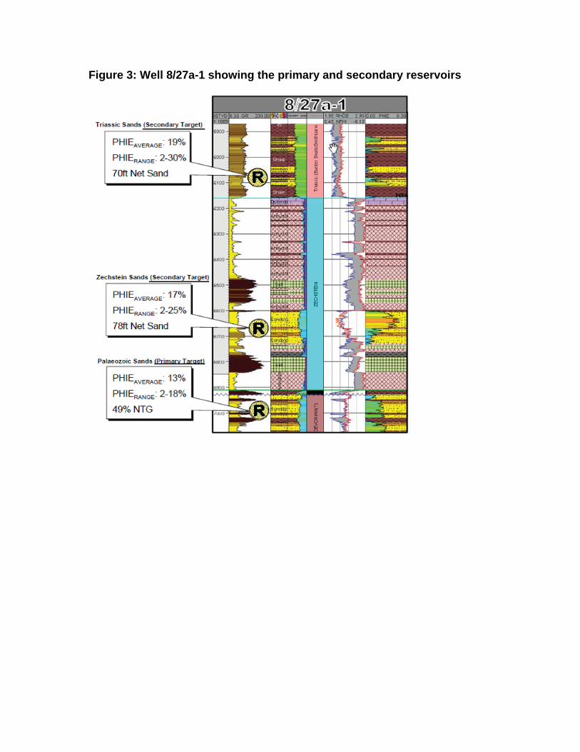
Figure 3: Well 8/27a-1 showing the primary and secondary reservoirs
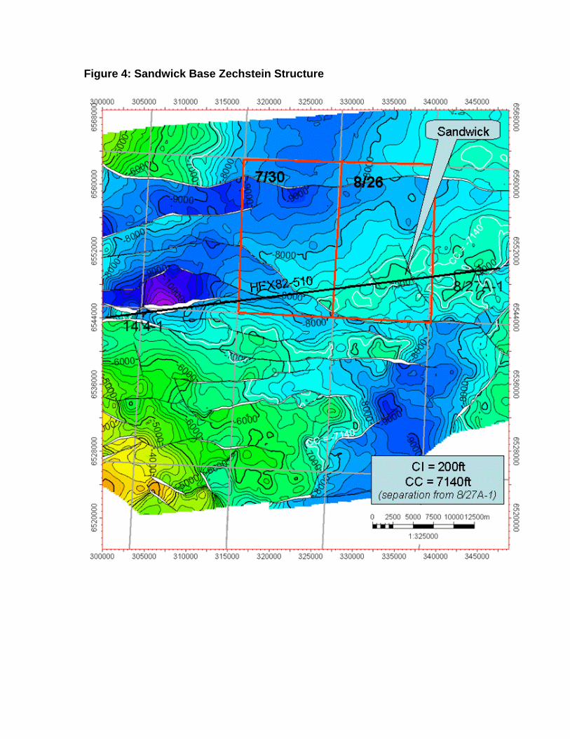
Figure 4: Sandwick Base Zechstein Structure
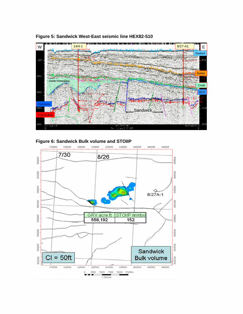
Figure 5: Sandwick West-East seismic line HEX82-510
Seabed
Balder
Chalk
BCU
Zechstein
B.Zechstein
W E
Sandwick
Lower Cretaceous
8/27-A114/4-1
Seabed
Balder
Chalk
BCU
Zechstein
B.Zechstein
W E
Sandwick
Lower Cretaceous
8/27-A114/4-1
Figure 6: Sandwick Bulk volume and STOIIP