Embed Size (px)
Citation preview
WG ON THE REVISION OF IHO PUBLICATION S-23 “LIMITS OF OCEANS AND SEAS” (S-23 WG) Second Meeting, Singapore, 5-7 July 2010
DRAFT MINUTES
Note: section numbering is the same as in the agenda 1.- REGISTRATION 2.- WELCOME ADDRESS BY THE HOST NATION 3.- WELCOME ADDRESS BY THE CHAIR OF THE S-23 WG 4.- ADMINISTRATIVE ARRANGEMENTS FOR THE MEETING Docs: S-23WG2-04A List of Documents (also Annex A) S-23WG2-04B List of Participants (also Annex B) S-23WG2-04C S-23 WG Membership List (also Annex C) The 2nd Meeting of the IHO WG on the Revision of IHO Publication S-23 “Limits of Oceans and Seas” (S-23 WG) took place at the Furuma Riverfront Hotel, Singapore, on 5-7 July 2010, under the Chairmanship of Vice Admiral Alexandros MARATOS, IHB President. The meeting was hosted and organized by the Hydrographic Department of the Maritime and Port Authority (MPA) of Singapore. Thirteen IHO Member Statesi, were represented at this meeting. In total, 42 delegates were in attendance. Dr. Parry OEI, Chief Hydrographer of the MPA Hydrographic Department, welcomed all participants. He very much hoped that the WG would move on and progress the „areas of concern‟ issues during this meeting. In his welcome address, Vice Admiral MARATOS, as S-23 WG Chair, thanked Dr. OEI for having accepted to host the 2nd S-23 WG meeting. He also thanked the Director of the Indonesian Hydrographic Office, Commodore Supriyanto, for his offer to host this meeting (however the IHB had already accepted the offer from Singapore). He was grateful to the S-23 WG Vice-Chair, Rear Admiral Christian ANDREASEN (USA), for his continuous support on the various issues under consideration. He emphasized the importance of this meeting and hoped that tangible results would be achieved. He stressed the long delay in progressing S-23 matters, from the IH Conference decision of 1977 to undertake a revision of S-23, to the establishment of this S-23 WG in 2009, as agreed by CL. He mentioned that the „areas of concern‟ issues had been progressed over the past year in accordance with the plan of actions agreed at the 1st S-23 WG Meeting in 2009. He warned that failure by the WG to come up with a positive report to Member States for a new edition of S-23, no later than June 2011, would be considered a failure on the part of the Organization to meet the expectations of the maritime community, international organizations, academia and private companies. The S-23 WG Secretary, Ing. en chef Michel HUET, IHB, drew attention to the documents available, as listed in Doc. S-23WG2-04A. USA remarked that India‟s letter to the IHB of 5 November 2009 relating to Malacca Strait, was missing under agenda item 11. It was agreed to make that letter Doc. S-23WG2-11D.
Outcome:
The WG noted the documents introduced, as amended.
5.- MEMBERS’ POSITIONS REGARDING THE PROPOSAL TO HOLD THE 2ND S-23 WG MEETING Docs: S-23WG2-05A Proposal to hold the 2nd S-23 WG Meeting: Members’ positions Referring to the above paper, the Chair indicated there was no opposition to holding another face-to-face meeting of the S-23 WG. However, France had some concerns that conditions may not be met for the meeting to achieve concrete results. Further they had suggested that two meeting days might be sufficient and noted the long distance for them to travel to the meeting place. The Chair commented that three meeting days were
2
proposed to give ample time for all issues to be fully discussed. He added that the meeting venue was proposed in this region because most of the identified „areas of concern‟ were located there. France mentioned that, while they are willing to actively participate in progressing S-23, they have to provide justification to the French authorities for their attendance of such meetings.
Outcome:
The WG noted the paper.
6.- APPROVAL OF THE AGENDA AND TIMETABLE Docs: S-23WG2-06A Agenda (also Annex D) S-23WG2-06B Timetable The Chair introduced the agenda. Referring to item 11, he mentioned that the issues for discussions would mainly relate to:
The Malacca & Singapore Straits;
China‟s proposals for changes in the South China Sea, the East China Sea and the Yellow Sea;
The sea area located between the Korean peninsula and the Japanese archipelago;
The Gulf / Sea of Oman. He drew attention to Doc. S-23WG2-13A submitted by France relating to the decisions and actions arising from this meeting. Answering a question from Japan on the methodology to be used, he said that proposers, who were present, would be invited to present their proposals. Then the floor would be opened for discussion. Regarding the issue in the 3rd bullet above, he would recall the proposals which had been formally made in the past. Morocco wanted to discuss two naming issues for features located on the NW African coast. It was agreed these would be addressed under item 12 - Any Other Business.
Outcome:
The WG approved the agenda, as amended, and the timetable without change.
7.- TERMS OF REFERENCE AND RULES OF PROCEDURE OF THE S-23 WG Docs: S-23WG2-07A Terms of Reference and Rules of Procedures for S-23 WG 8.- REPORT OF THE 1ST MEETING OF THE S-23 WG Docs: S-23WG2-08A Final Minutes of the 1st S-23 WG Meeting 9. REPORT OF THE WORK OF THE S-23 WG, BY THE CHAIR Docs: S-23WG2-09A Report on the Status and Progress of the Work of the IHO S-23 WG 10. PRELIMINARY COMMENTS BY THE PARTICIPANTS The Chair recalled that draft ToR/RoP for the WG were initially proposed by CL, together with the proposed holding of the 1st WG meeting in conjunction with the 2009 Extraordinary IHC, and revised at that meeting as reflected in Doc. S-23WG2-07A. He mentioned that all S-23-related documents, including the 1986 and 2002 drafts 4th edition of S-23, were posted in a password-protected section of the IHO website. Referring to his progress report in Doc. S-23WG2-09A and to the „ways of progressing the work of the S-23 WG‟, as agreed at the 1st WG meeting (Annex H to S-23WG2-08A), the Chair noted that:
3
1. Step 1 - IHB to set up an S-23 WG on the IHO website - had been completed (see http://www.iho-ohi.net/english/committees-wg/s-23wg.html).
2. Step 2 - France (SHOM) to provide the IHB with standards, definitions and rules of procedure for toponymy; IHB to post these documents on the IHO website – had been completed (see http://www.iho-ohi.net/mtg_docs/com_wg/S-23WG/S-23WG_Misc/Toponymy/S-23WG_Toponymy_EN.pdf).
3. Step 3 - IHB to circulate a list of areas of possible concern to WG members by end July 2009 – had been completed. IHB e-mail of 8 July 2009 refers.
4. Step 4 - WG members to comment on this list by end September 2009 – had been completed. All answers were compiled into a „compendium of replies‟ which was posted on the IHO website.
5. Step 5 - IHB to circulate a final list to WG members; Member States in any areas of possible concern then to be asked to provide their comments/positions – had been completed. IHB Letter S3/7020 of 9 November 2009 refers.
6. Step 6 - Based on the comments received from interested Member States in any areas of concern, IHB to draft a paper on the matter, circulate it to WG members and consider whether a face-to-face meeting is appropriate – had been completed. Doc. S-23WG2-09A „Chairman‟s Report on the Status and Progress of the Work of the IHO S-23 WG‟ refers.
Australia stated that they have accepted international limits of the Southern Ocean, as laid down in the 2002 draft of S-23, providing that the Australian interpretation that its northern limit coincide with the southern shore of Australia be recognized in an annex to S-23. He suggested this could be an example to follow to resolve some pending issues. He stressed that it was critical that a new edition of S-23 can soon be published. If not, he believed that the IHO should withdraw the 3rd edition of S-23 which is out of date (1953), and remove S-23 from the list of IHO publications. France, referring to ToR 1.2 – (The S-23 WG shall) submit (a revised draft 4th edition of IHO Publication S-23, Limits of Oceans and Seas,) together with a Report of the work of the WG to the IHB no later than June 2011, for the subsequent approval of Member States – and RoP 2.6 - Decisions should generally be made by consensus – asked how the WG would proceed if no consensus was reached? The Chair answered that he hoped that a compromise could be found on the various topics. Japan, while reiterating their willingness to contribute to progressing S-23 matters, referred to the IHO Convention where it is said that the IHO is a technical and consultative organisation, whose objective is to make navigation safer via standards. Korea (Rep. of) emphasized the need to make substantial progress at this meeting and referred to IHO Resolution A4.2 (now re-numbered 1/1972), paragraph 6, as a possible solution to progress some issues. Indonesia mentioned that they were currently in the process of preparing a document on “Indonesian Limits of the Seas”. The Chair pointed out that the IHO is a technical and consultative Organization not dealing with issues of international policy in accordance with our Documents. Our discussions must be based only on the technical aspects of the issues under consideration. The Chair reminded everyone that participation in the S-23 WG was open to all Member States, in accordance with RoP 2.1.
Outcome:
The WG noted the ToR/RoP, minutes and report.
11.- TOPICS TO BE CONSIDERED 11.1. Malacca Strait Docs: S-23WG2-11A Areas of Concern: Views expressed by WG Members
S-23WG2-11D Letter from India on Malacca Strait
The Chairman indicated that India‟s proposal was to move the Malacca Strait from Chapter 6 (South China Sea and Eastern Archipelagic Seas) to Chapter 5 (Indian Ocean). India further suggested changing the western limit
4
of the Malacca Strait from T. Jamboaye (Sumatra, Indonesia) – Lem Phra Chao (Thailand) to Pedropunt (Sumatra, Indonesia) - Lem Phra Chao. These changes are illustrated in the diagram at Annex E. The Chair, with strong support from Singapore, suggested considering the Malacca and Singapore Straits together, on the basis that the two straits form a single continuous waterway. This was agreed. The Vice-Chair referred to a statement by the 1919 IHC that “Straits joining two seas have been allotted to one of them”, suggesting that Malacca & Singapore Straits should be treated accordingly. Singapore remarked that both straits fall under NAVAREA XI (Japan coordination), INT Region K (Japan coordination) and the East Asia Hydrographic Commission; it seems therefore logical to associate the Malacca & Singapore Straits with Chapter 6. Referring to paragraph 4 in Doc. S-23WG2-11D, Singapore‟s views were that the main contributor to improving the safety of navigation in the straits has been Japan. Indonesia expressed preference for the Malacca & Singapore Straits, due to its importance to international navigation and safety at sea, to be considered a separate body of water, independent from the Indian Ocean (Chapter 5) and the South China Sea and Eastern Archipelagic Seas (Chapter 6), as in the 3rd edition of 1953. They reported that Indonesia, already a member of the East Asia Hydrographic Commission, was currently in the process of joining the North Indian Ocean Hydrographic Commission. They suggested that a new RHC be formed to address the issues pertaining to the Malacca & Singapore Straits. On the latter point, the Chair commented that RHC establishment is an issue for littoral States to address. The lack of justification by India for the Malacca Strait to be part of the Indian Ocean was emphasized by Japan and Singapore. There being diverging views on this proposal, i.e. with Australia, China, France, Japan, Nigeria and Singapore expressing preference for the Malacca & Singapore Straits being placed in Chapter 6, whereas Malaysia (not represented at the meeting), UK and USA preferring to have the straits in Chapter 5, and Indonesia suggesting they form an independent body of water, the Chair proposed that this issue be re-visited later during the meeting, thus giving participants the opportunity to give further thoughts to the matter. This was agreed. Re-visiting the Malacca & Singapore Straits issue on the last day of the meeting. The Chair asked if there was any objection to the proposed change by India to the western limit of the Malacca Strait. There was none. The proposed new western limit was therefore agreed. Singapore reiterated that no technical reason or justification had been provided for placing the Malacca Strait in the Indian Ocean, further noting that India does not share any maritime boundary in the Malacca Strait. Indonesia maintained their position that the Malacca & Singapore Straits should be treated as an independent maritime area. Australia reported that the proposal which was made in 1999 by Australia to associate the Malacca & Singapore Straits with Chapter 6, aimed at facilitating S-57 ENC encoding at that time. As this justification was no longer relevant, Australia stated that the 1999 Australian proposal (letter AH 26/074/03 of 14 April 1999) should be considered withdrawn. Japan emphasized that there was a need for smooth and safe navigation throughout the Malacca & Singapore Straits. As a result, they were inclined to support Indonesia‟s proposal for an independent area. After discussion, Indonesia‟s proposal for the Malacca & Singapore Straits to form an independent maritime area within S-23 was agreed.
Outcomes:
The WG agreed that the Malacca and Singapore Straits be considered an independent area forming a separate administrative division in S-23, due to their significance for international
5
navigation.
Amendment of the western limit of the Malacca Strait, as proposed by India, was agreed by the WG.
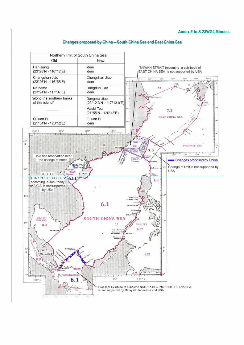
11.2. South China Sea – East China Sea – Yellow Sea Docs: S-23WG2-11A Areas of Concern: Views expressed by WG Members S-23WG2-11C Southern Limit of the Yellow Sea – Comment by Rep of Korea The Chair indicated that China had requested a number of changes to the limits and names in South China Sea, East China Sea and Yellow Sea – Bo Hai, as reflected in section 10 of Doc. S-23WG2-11A and the diagrams at Annexes F and G.
a. To consider the South China Sea an independent area forming a separate administrative
division in S-23.
China explained that, as the traditional geographical concept with a clear definition, South China Sea refers to the vast water area to the south of China mainland, the east of Indochina peninsula, the north of Lathu Jawa, and the west of Philippine archipelago. It would not match the traditional name, and would also easily result in illegibility in the geographic concept, if South China Sea is considered as a part of South China Sea and Eastern Archipelagic Seas. China therefore suggested that South China Sea be an absolute subdivision in S-23. USA did not support splitting the section currently titled South China and Eastern Archipelagic Seas and its Subdivisions and creating a separate entity for South China Sea. This would complicate matters with the Gulf of Thailand being left alone. The Chair felt there was not enough support for this proposal and suggested deferring its consideration. This was agreed. China presented the proposal after the WG agreed that the MSS be considered an independent area forming a separate administrative division in S-23 due to their significance for international navigation. China emphasized that the South China Sea‟s situation is the same as the MSS, if not much busier and more important than the MSS. This item did not receive any objection, only with one minor comment made by the US, reminding that the Gulf of Thailand has the same status with the South China Sea. This proposal was therefore agreed.
Outcome:
The WG position was to defer consideration of China‟s proposal to make the South China Sea an independent area within S-23. (Meeting participants to provide comments on this issue till the end of August 2010 in order to determine the way forward.)
The WG agreed that the South China Sea be an independent area forming a separate administrative division in S-23, due to their significance for international navigation.
b. To subsume Natuna Sea into South China Sea, so that the southern limit of South China
Sea would be the same as in the 1953 3rd edition of S-23.
Indonesia strongly supported that Natuna Sea be shown as an individual body of water, as in the 2002
draft of S-23, 4th edition, and not included as part of South China Sea. They referred to a national law
6
(No. 6/1996), nautical chart 38/1951, several government regulations and a treaty between Indonesia
and Malaysia, all supporting the recognition and usage of Natuna Sea in Indonesia.
The Chair reminded the group that Malaysia‟s position was also that Natuna Sea should not be absorbed as part of South China Sea. USA expressed similar views, adding that the body of water south of the Natuna and Anambas Islands and north of Bangka and Belitung Islands and Java Sea has the characteristics of a distinct sea feature, and the name Natuna Sea would be a potentially appropriate name for this sea area.
There being no support for this proposal, There being no other comments from participants, the Chair
invited China to re-consider their position.
Outcome:
The WG position was not to include Natuna Sea in South China Sea, as proposed by China. China to re-consider their position and/or provide additional information to the Chair for circulation to meeting participants.
c. To rename Beibu Gulf the existing Gulf of Tonkin, based on a 2005 an agreement dated
on Dec. 25, 2000, with Vietnam.
Answering a request from Japan, the Chair confirmed that Vietnam, not being an IHO Member State, had not been consulted on this issue by the Secretariat. The positions expressed by various participants were that the official agreement between China and Vietnam, on which this proposal was based,
should be made known to WG members. China agreed to provide this agreement.
This being said, several participants (France, UK, USA) advocated that the name Gulf of Tonkin was
well known and suggested it be retained in some way, as names must be understood by all potential
users, not only in neighbouring countries. Suggestions were made to use either Beibu Gulf (Gulf of
Tonkin) or Beibu Gulf with a footnote saying “Also known as Gulf of Tonkin”.
France wished to make it clear that they have no objection to the name Beibu Gulf, as priority should be
given to local names as long as they are approved by the neighbouring countries. However, for the
same toponymic reasons and principles explained for the naming of other areas, France strongly
recommended using Gulf of Tonkin as a possible variant, together with Beibu Gulf, in order that the
designation of this area can unambiguously be identified and understood by the international
community. In any case, the French exonym which will be used to designate that gulf will be Golfe du
Tonkin.
Japan remarked that Beibu is a Chinese term meaning “north” or “northern”, i.e. in line with the position
of the gulf with respect to South China Sea, whereas the Vietnamese equivalent term is Vinh Băc Bô.
Korea (Dem. P. Rep. of) expressed support for China‟s proposal to use Beibu Gulf instead of Gulf of
Tonkin.
Summing up, the Chair indicated that China has accepted to make available the 2005 agreement dated on Dec. 25, 2000, between China and Vietnam referring to Beibu Gulf, to be considered by the participants which will provide their positions to the Chair. The Chair based on the responses will propose the way forward.
7
Outcome:
China to provide the Chair with the official agreement with Vietnam and information on actual technical usage, for circulation to meeting participants. Based on the responses received, the Chair will propose a way forward.
d. To consider Beibu Gulf (Gulf of Tonkin) a sub-body of South China Sea.
Australia remarked that there seemed to be no gulf being a sub-body of a sea in S-23. If confirmed, this
would create a precedent. However, there was no objection to this proposal which was therefore
accepted.
Outcome:
The WG agreed that Gulf of Tonkin / Beibu Gulf be considered a sub-body of South China Sea, as proposed by China.
e. To slightly amend the northern limit of South China Sea.
There was no objection to this proposal which was therefore accepted.
Outcome:
Alteration of South China Sea‟s northern limit, as proposed by China, was agreed by the WG.
f. To consider Taiwan Strait a sub-body of East China Sea.
USA opposed this proposal, considering that Taiwan Strait, as an international waterway of some significance, deserved its current designation as a distinct component of the North Pacific Ocean section of S-23. UK and France expressed similar views. Only Korea (Dem. P. Rep. of) was supportive of the proposal. The Chair summarized that there was not enough support for this proposal.
Outcome:
The WG concluded that Taiwan Strait should remain a separate body.
g. To amend to Taiwan Dao the name of this island.
China explained that the name shown for the relevant island on the diagram relating to Taiwan Strait in
the 2002 draft S-23, 4th edition, is TAIWAN (in fact, it appears as “T‟AI-WAN”, but to be spelled
“TAIWAN” in accordance with the spelling corrections in section 9 of China‟s paper). According to
China‟s survey and mapping policy, it should be labeled “Taiwan Dao”.
Nigeria expressed support for China‟s proposal.
8
Japan circulated a chartlet of the East Asia region originating from the UN Secretariat and showing
“TAIWAN” as the name for this island. As a result, Japan did not see any need to change the existing
name. China remarked however that the chartlet included a footnote stating that it was not an official UN
document.
Australia suggested that an option could be for China to put a reservation about “TAIWAN” in S-23 that
China names this island “Taiwan Dao”, similarly to the reservation made by Australia with respect to the
northern limit of the Southern Ocean. USA supported this approach. Australia also referred to the
preamble of S-23 stressing that the information contained in S-23 has no political significance.
It was generally agreed that, although it‟s not the IHO role to deal with names on land but to focus on
maritime limits, there is a need to agree on which topographic names should be used in S-23. Various
options were suggested, including going to Member States by Circular Letter (Rep. of Korea), using
exonymsii (France) or seeking advice from the UN Group of Experts on Geographical Names
(UNGEGN) (Chair, Australia, Indonesia, USA). Regarding the first option, i.e. going to MS, Australia
believed that the work should be done by this WG and not be given to MS.
The Chair summarized that there was not enough support for this proposal. He invited all participants to
provide their views by the end of July 2010.
China requested that all their proposed name changes, as listed in section 9 of China‟s paper, be
considered during this meeting, not only “Taiwan / Taiwan Dao”. The Chair answered this would be
addressed later during the meeting (see § 11.2.m).
China emphasized that this is purely a national technical policy to standardize geographical names
across the whole of China and the names have been submitted to the UN for registration. There are a
list of names, including the biggest island, Hainan, in China that required changing. It is very abnormal
to find that the Meeting had singled out the change of name on this particular island which meant
bringing in political issue into the technical discussion.
Outcome:
Meeting participants to provide to the Chair their views on China‟s proposal to name the island “Taiwan Dao” instead of “TAIWAN”, by end of July 2010. Based on the responses received, the Chair will propose a way forward.
h. To change East China Sea’ southern limit, from Hateruma Shima – Fu-kuei Chao to
Hateruma Shima – Amianan – E’luan Bi, so as to include a portion of the existing
Philippine Sea in the East China Sea.
China explained that “Taiwan Dao” is part of China and should therefore be entirely included in East
China Sea. It was not really a proposal to change the limits but instead trying to point out these should
be the original limits of the East China Sea. The existing southern limit of East China Sea dates back to
1953 or earlier, i.e. at a time when China was not part of the IHO and therefore did not have a say. The
Chair noted that the Philippines have not commented on this proposal (or on any other proposals).
9
USA strongly disagreed with this proposal. Japan and France did not support the proposal and recalled
that the IHO is a purely technical and consultative body, i.e. not political.
Korea (Dem. P. Rep. of) expressed support for this proposal.
The Chair summarized that there was not enough support for this proposal.
Outcome:
The WG concluded that the existing limit should be retained.
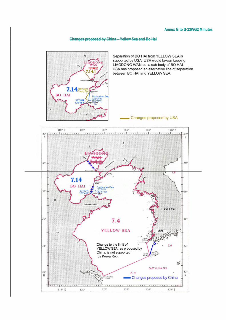
i. To remove Liaodong Wan as a sub-body of Bo Hai.
China explained that Liaodong Wan is one of three Bo Hai‟s gulfs and suggested to merge this shallow
water area into Bo Hai.
USA initially expressed preference that Liaodong Wan still be treated as a sub-division under Bo Hai. However, after discussion, there was consensus to support China‟s proposal.
Outcome:
China‟s proposal to remove Liaodong Wan as a sub-body of Bo Hai was agreed by the WG.
j. To consider Bo Hai a separate body from Yellow Sea.
China explained that according to the geographic character of Bo Hai, these are Chinese internal waters, and not part of the Yellow Sea. Bo Hai should therefore form a separate body from the Yellow Sea. Japan stated they cannot support the proposed separation of Bo Hai from the Yellow Sea on the grounds that these are Chinese internal waters. The Chair felt that qualifying Bo Hai as „internal waters‟ may have legal implications. After discussion, China withdrew its statement that Bo Hai constitutes China‟s internal waters. They further accepted to provide a technical rationale in writing for separation of Bo Hai from the Yellow Sea. This proposal did not receive any objection. Japan oppugned the description of “Bo Hai is Chinese internal waters”. China explained that Japanese question went beyond the technical characteristic of this meeting. On this basis, the Chairman summarized that China‟s proposal that Bo Hai be treated as an independent area separated from the Yellow Sea, was accepted in principle providing appropriate justification be given by China.
Outcome:
Separation of Bo Hai from the Yellow Sea, as proposed by China, was agreed in principle by the WG. China to provide written technical justification to the Chair who will circulate it to the meeting participants for final approval.
k. To amend the line of demarcation between Bo Hai and Yellow Sea.
10
China proposed to slightly amend the line of demarcation between Bo Hai and the Yellow Sea (see
paragraph 6.c of China‟s paper – section 10 of Doc. S-23WG2-11A), as illustrated at Annex G.
USA subsequently proposed an alternative line which, in their view, represents a more natural separation of Bo Hai from the Yellow Sea (see USA‟s paper – Section 8 of Doc. S-23WG2-11A, and Annex G). There were also questions about the rationale for the existing line in the 2002 draft 4th edition of S-23, which dates back to the 1986 draft (Bo Hai does not appear at all in the 1953 3rd edition of S-23). China and USA accepted to provide a justification in writing for their proposed changes. In addition, the IHB offered to search for the rationale of the existing line in the IHB archives relating to the 1986 draft. On this basis, the Chair summarized that the revised line of demarcation between Bo Hai and Yellow Sea, as proposed by China, was accepted in principle providing appropriate rationale be given by China, taking also into consideration the comments/information from USA and IHB.
Outcome:
The new line of demarcation between Bo Hai and the Yellow Sea, as proposed by China, was agreed in principle by the WG. China and USA to provide the Chair with written technical justification for their respective proposals. These, together with IHB findings on the justification for the existing line dating back to 1986, will be circulated to meeting participants for final approval.
l. To amend the eastern limit of the Yellow Sea.
In connection with Rep. of Korea‟s comments in Doc. S-23WG2-11C, China and Rep. of Korea announced that they would hold bi-lateral discussions on this issue, following the meeting. As a result, they suggested there was no need to further discuss this point during the meeting. Japan expressed interest in participating in such bi-lateral discussions. China and Rep. of Korea did not respond to Japan‟s request.
The Chair stressed that the above bi/tri-lateral bi-lateral discussions should take place as soon as
possible and that their outcomes should be made available to all WG members, for them to review and
comment. This was agreed.
Outcome:
Bilateral discussions to take place between China and Rep of Korea regarding the changes proposed by China on the eastern limit of the Yellow Sea. Outcome of these discussions to be sent to the Chair by end of July 2010 as soon as possible for circulation to the meeting participants.
m. To correct the spelling of several geographical names, and add some new names,
relating to South China Sea, East China Sea and Yellow Sea (see paragraph 9 of China’s
paper – section 10 of Doc. S-23WG2-11A).
There was no objection to the spelling corrections and addition of names, as proposed by China, further
noting that the cases of Beibu Gulf / Gulf of Tonkin and “TAIWAN” / “Taiwan Dao” had been addressed
separately.
11
Outcome:
The spelling corrections for various geographical names and the addition of new names in South China Sea and East China Sea, as proposed by China, were agreed by the WG, noting that the issues of Beibu Gulf / Gulf of Tonkin and “TAIWAN” / “Taiwan Dao” have been addressed in § 11.2.c and 11.2.g, respectively.
11.3. Naming of sea area between the Korean Peninsula and the Japanese Archipelago Docs: S-23WG2-11A Areas of Concern: Views expressed by WG Members The Chair provided a brief historical background on the naming of this sea area with respect to S-23. In the existing 1953 3rd edition, as well as in earlier editions, this sea area is called Japan Sea. In the draft 1986 4th edition, it still appears as Japan Sea. In the draft 2002 4th edition, there were blank pages for that area. From 2003 to 2006, several meetings were reportedly held between Japan and Rep. of Korea on the matter, with no success. At the 2007 IHC, the Conference President proposed to publish S-23 in two volumes, with the first volume dealing with non-contentious areas and which can be published without delay, and the second volume dealing with areas of concern, to be published when solutions have been agreed. This proposal was not accepted. In 2008 the Baltic Sea Hydrographic Commission proposed a regional approach, i.e. each RHC would take responsibility for its relevant part in S-23, to be published as and when it has been completed and agreed. Member States did not accept this proposal, while at the same time recognizing the urgent need to produce an updated edition of S-23. In 2009, Member States agreed that a WG (this WG) be established to progress the production of a 4th edition of S-23. Meanwhile, the IHB has received numerous requests for an up-to-date S-23 from various institutions worldwide, including the ISO, EU and scientists. This has resulted in an embarrassing situation for the IHB/IHO. The Chair reiterated that if the WG fails to reach an agreement, the only remaining option could be to cancel S-23 as an IHO publication. Korea (Dem. P. Rep. of) stated that the name Japan Sea was included in the first edition of S-23 (1928) as a result of the colonial power status of Japan at that time. However, geographical names should be established on the basis of history and legitimacy. The name East Sea has been in use by Korean people for at least two thousands years. Korea (Dem. P. Rep. of) referred to an early 19th century Japanese map, showing this sea area as Sea of Josen (meaning Sea of Korea) and the sea area off the eastern coast of the Japanese archipelago as Sea of Japan. They stated that in most of the maps and books published in the 18th and 19th centuries in western countries, the sea area between Korea and Japan was referred to as East Sea or Sea of Korea or Oriental Sea (or their exonyms if not in English). However, they proposed using both names, i.e. Japan Sea and East Sea, in accordance with IHO and UN regulations on geographical names. In any case, they would strongly object to using the sole name Japan Sea and recommended that the name for the sea area in question be left blank until an agreement was reached among the concerned States. Korea (Rep. of) expressed similar views and distributed several leaflets with maps showing the names East Sea, Sea of Korea and/or Sea of Josen. They referred to the national anthem of Korea (Rep. of) starting with the name East Sea. They said that the fact that the sea area in question is shared by four countries should be respected by Japan. Like Korea (Dem. P. Rep. of), they advocated using both names Japan Sea and East Sea and applying IHO Resolution A4.2 (now re-numbered 1/1972), paragraph 6. In their view, S-23 should contain information on names as provided by Member States. They suggested issuing a circular letter asking for names that IHB would collect and include in S-23. Should there be several names for a given sea area, it would be up to each government to decide which name to use. Japan stated that recognizing the importance of history was only one part of the matter. In the 18th and 19th centuries, Japan was a closed country and was therefore not in a position to influence western geographers / cartographers. Japan started using the name Japan Sea to designate the sea area between Korea and Japan from 1867. Japan added that the name Japan Sea was widely used and known internationally and they were not in favour of using the above mentioned IHO Resolution. France gave a presentation proposing a technical solution to this issue. This solution is based on the concept of:
12
Endonyms: local usage, i.e. name written in a local language. For example, Rio Tejo (Portuguese),
Pulau Sudong (Indonesian), 日本海 (Japanese) or 동해 (Korean). For understanding purposes, an
endonym may need to be transliterated / romanized, e.g. 日本海 (Japanese) is romanized into Nippon-
kai and 동해 (Korean) is romanized into Donghae.
Exonyms: foreign / international usage, i.e. name written in a language which is not spoken in the place it designates. For example, exonyms in English of the above four names could be Tagus River, Sudong Island, Japan Sea and East Sea, respectively.
Based on the above, France proposed that wherever there was no agreement on a single name for a given sea area, then endonyms, romanized if necessary, could be used in association with international exonyms to be agreed in English and/or French, i.e. the two official languages of the Organization. In English, this could result in the following examples: Donghae (East Sea), Donghae (Japan Sea), Nippon-kai (Japan Sea) or Nippon-kai (East Sea). USA stressed there was a need to agree on the English version of S-23 first. Australia, Korea (Rep. of) and Nigeria expressed sympathy and support for France‟s proposal. Japan felt this proposed solution could apply to other issues as well. While they were prepared to study France‟s proposal in detail, they also wished to make an alternative proposal, based on the following principles:
Revision of S-23 would be based on the 2002 draft, except for “areas of concern” where the 1953 3rd edition would be used.
Any proposal for change would be considered on a case-by-case basis. After approval by all littoral States, it would be submitted to the S-23 WG for consideration and endorsement, then to the next IHC for final approval.
Korea (Rep. of) questioned the fact that Japan, being a party to this issue, could put forward a proposal. However, after discussion it was agreed that proposals will be considered by the WG. Japan was asked to provide the details of their proposal in order to be posted on the IHO web site. Korea (Rep. of) indicated that they were prepared to also make a proposal. After discussion, it was agreed that Korea would provide the details of their proposal to be posted on the IHO website. Australia proposed that, when no consensus can be reached on a single name for a given sea area, the following method applies:
a. a reservation by (an) other Member State(s) is included on the main page referring to the sea area, and details of the reservation, such as an alternative name/limits be clearly detailed in an Annex; or
b. a reservation by (an) other Member State(s) is included on the first page referring to the sea area and a second page for the same sea area is inserted in S-23 immediately following the first. The second page will show the alternative name(s) or limits of the sea area where consensus was not reached.
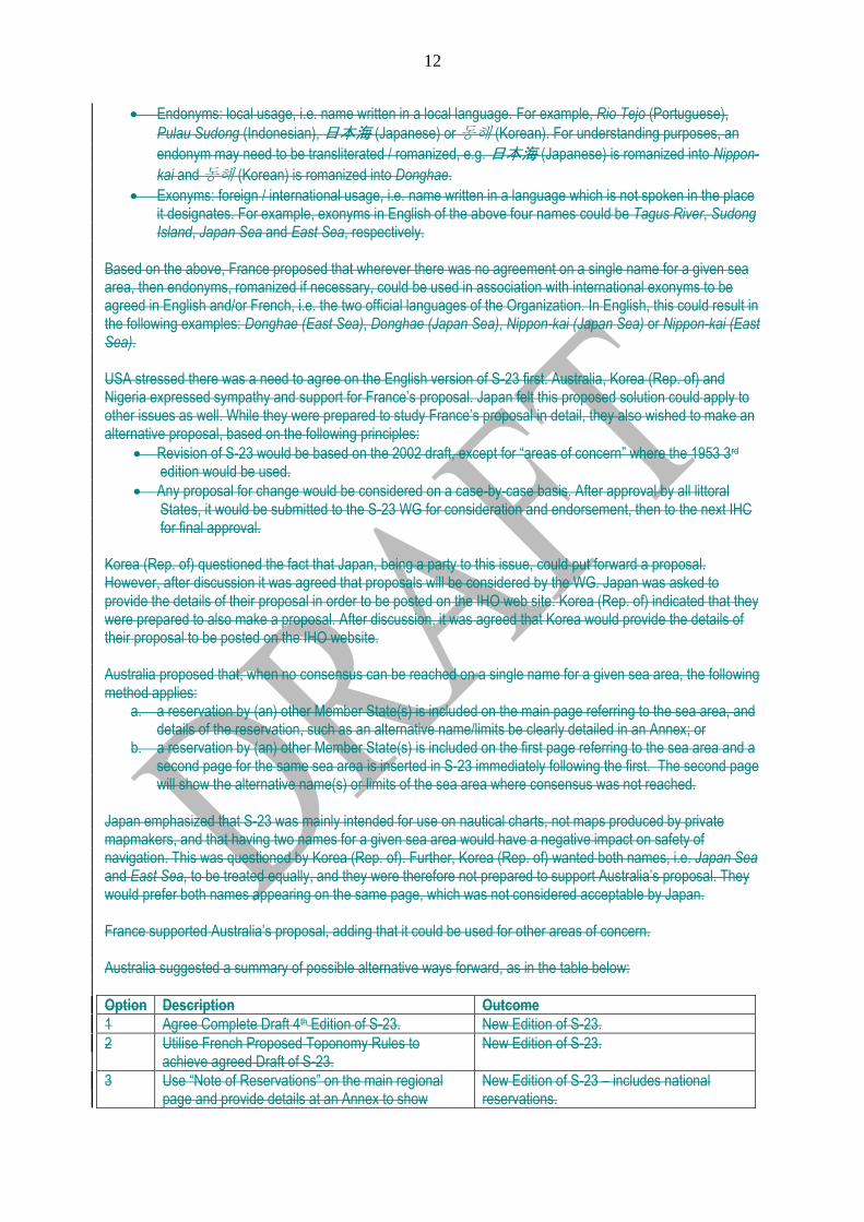
Japan emphasized that S-23 was mainly intended for use on nautical charts, not maps produced by private mapmakers, and that having two names for a given sea area would have a negative impact on safety of navigation. This was questioned by Korea (Rep. of). Further, Korea (Rep. of) wanted both names, i.e. Japan Sea and East Sea, to be treated equally, and they were therefore not prepared to support Australia‟s proposal. They would prefer both names appearing on the same page, which was not considered acceptable by Japan. France supported Australia‟s proposal, adding that it could be used for other areas of concern. Australia suggested a summary of possible alternative ways forward, as in the table below:
Option Description Outcome
1 Agree Complete Draft 4th Edition of S-23. New Edition of S-23.
2 Utilise French Proposed Toponomy Rules to achieve agreed Draft of S-23.
New Edition of S-23.
3 Use “Note of Reservations” on the main regional page and provide details at an Annex to show
New Edition of S-23 – includes national reservations.
13
alternative national positions.
4 Include an additional page in the main regional section of S-23 to detail national reservations adjacent to the page showing customary use.
New Edition of S-23 – clearly shows national positions that differ from customary use.
5 Publish Agreed areas of S-23 in one volume with “yet to be agreed areas” designated for a second volume.
Enables publication of new edition of S-23 for most of the world oceans.
6 Publish S-23 in Regional Volumes under the leadership of the RHCs.
Enables publication of regional new edition of S-23 for most of the world oceans.
7 Consideration of the Japanese proposal – yet to be formally tabled.
?
8 Withdraw S-23 Edition 3 and admit failure to update the document.
Embarrassment to IHO – undermines viability of the organisation. Leaves a void - there will be no single document to show the agreed and national positions on Names and Limits of the Oceans and Seas.
There were various comments. None of the participants wanted option 8 to happen. The Vice Chair suggested that S-23 could be published chapter by chapter, like publication S-11 (Catalogue of INT charts), and he would therefore favour option 5. Japan felt there would be a need for another meeting of the S-23 WG. The Chair summarized that all four proposals from Australia, France, Japan and Korea (Rep. of) would be posted on the IHO website, for WG members to review and provide their comments / positions to the Chair before the end of August 2010. Based on the comments received the Chair will indicate the way forward, with another face-to-face meeting standing as an option. Post-meeting note: the available proposals have been posted at http://www.iho-ohi.net/mtg_docs/com_wg/S-23WG/S-23WG2/Proposals/S-23_Proposals.htm.
Outcome:
Australia, France, Japan and Republic of Korea to provide the Chair with their proposals for circulation to the members of the WG. Meeting participants and WG members not attending the meeting to provide the Chair, by the end of August 2010, with their views on these proposals. Based on the responses received, the Chair will propose a way forward.
11.4 Gulf / Sea of Oman Docs: S-23WG2-11B Gulf / Sea of Oman – Correspondence with Oman Embassy in France The Chair explained that the IHB had received a letter from the Oman Embassy in Paris, France, reporting on the Government of Oman‟s decision to change to Sea of Oman the name of the maritime area currently known as Gulf of Oman, further asking the IHO to reflect this change in its official publications. He noted that the 1953 3rd edition of S-23 includes Gulf of Oman for this area and Arabian Sea for the adjacent sea area south-eastwards. France gave a presentation showing that the area in question has always been depicted on charts as Gulf of Oman since 1865 at least. However, the existing Arabian Sea appeared as Sea of Oman on some old charts and even sometimes as Arabian Sea (Sea of Oman). Noting the definitions provided in the IHO Hydrographic Dictionary (S-32) for Gulf, i.e. “a part of the sea extending into the land, usually larger than a bay” and for Sea, i.e. “One of the smaller divisions of the oceans”, France suggested that Gulf is a more appropriate generic term than Sea for this maritime area. Further, changing from Gulf of Oman to Sea of Oman could lead to confusion regarding the geographical extension of this maritime area, considering the historical names which may still be in use for the Arabian Sea, e.g. Sea of Oman or Sea of Oman as a variant of Arabian Sea. As a result, France recommended keeping the name Gulf of Oman and using Sea of Oman as a possible variant for Arabian Sea.
14
Oman clarified that their initiative only relates to the maritime area which is shown in S-23 as Gulf of Oman, which they think is a Sea, and they were not asking to add Sea of Oman as a variant of Arabian Sea. Oman also asked how the limits of Strait of Hormuz were introduced. USA concurred with France that this maritime area does not qualify as a Sea and that the name Gulf of Oman should be retained. The Chair summarized that, although Oman can use any name for national use, there was no support for the change from Gulf of Oman to Sea of Oman.
Outcome:
The WG examined the letter received at the IHB from the Sultanate of Oman and did not support the proposed change from Gulf of Oman to Sea of Oman. IHB to provide Oman with historical information on the limits of the Strait of Ormuz.
12.- ANY OTHER BUSINESS 12.1. Morocco’s proposals Morocco explained that the cape at the north west of Morocco was wrongly spelled Ras Espartel in the 1986 and 2002 drafts 4th edition of S-23. The correct spelling is Ras Spartel, as in the 1953 3rd edition. There was no objection to this correction. Morocco also requested that the name Punta Almina, which is shown in the 2002 draft for this cape on the south east of Strait of Gibraltar, be changed to Ras Almina, further mentioning that it was named Almina Point in the 1986 draft. There was no support for this change.
Outcome:
Change from Ras Espartel to Ras Spartel, as proposed by Morocco, was agreed by the WG. The WG position was not to change from Punta Almina to Ras Almina, as proposed by Morocco.
12.2. Indonesia’s presentation Indonesia gave a presentation “Comprehensive Maritime Mechanism for Cooperations in the Straits of Malacca and Singapore”, providing information on the existing agreements / conventions between littoral States. 13.- DECISIONS OF THE MEETING AND ACTIONS ARISING Docs: S-23WG2-13A Proposal to include one step in the next S-23 WG work programme July 2010 – June 2011 (France) A list of outcomes from the meeting is provided at Annex H. A draft of this list was distributed to all participants and the Chair invited comments by the end of July 2010. 14.- REPORT TO MEMBER STATES 15.- CLOSING REMARKS BY THE CHAIR Indonesia indicated that, should another meeting of the S-23 WG be needed, they would be pleased to host such a meeting.
The Chair thanked all participants for their contribution to the meeting.
The meeting closed at 17:00 on 7 July 2010.

15
16
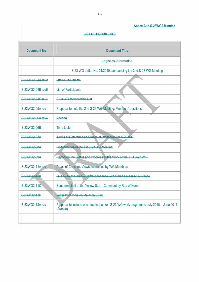
Annex A to S-23WG2 Minutes
LIST OF DOCUMENTS
Document No Document Title
Logistics Information
S-23 WG Letter No. 01/2010, announcing the 2nd S-23 WG Meeting
S-23WG2-04A rev2 List of Documents
S-23WG2-04B rev6 List of Participants
S-23WG2-04C rev1 S-23 WG Membership List
S-23WG2-05A rev1 Proposal to hold the 2nd S-23 WG Meeting: Members‟ positions
S-23WG2-06A rev4 Agenda
S-23WG2-06B Time table
S-23WG2-07A Terms of Reference and Rules of Procedure for S-23 WG
S-23WG2-08A Final Minutes of the 1st S-23 WG Meeting
S-23WG2-09A Report on the Status and Progress of the Work of the IHO S-23 WG
S-23WG2-11A rev1 Areas of Concern: Views expressed by WG Members
S-23WG2-11B Gulf / Sea of Oman – Correspondence with Oman Embassy in France
S-23WG2-11C Southern Limit of the Yellow Sea – Comment by Rep of Korea
S-23WG2-11D Letter from India on Malacca Strait
S-23WG2-13A rev1 Proposal to include one step in the next S-23 WG work programme July 2010 – June 2011 (France)
17
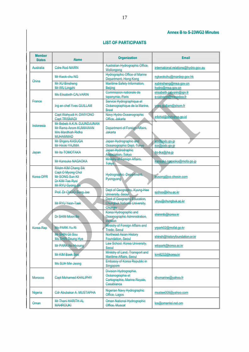
Annex B to S-23WG2 Minutes
LIST OF PARTICIPANTS
Member States Name
Organization Email
Australia Cdre Rod NAIRN Australian Hydrographic Office, Wollongong
China
Mr Kwok-chu NG Hydrographic Office of Marine Department, Hong Kong
Mr XU Binsheng Mr WU Lingzhi
Maritime Safety Information, Beijing
[email protected] [email protected]
France
Ms Elisabeth CALVARIN Commission nationale de toponymie, Paris
[email protected] [email protected]
Ing en chef Yves GUILLAM Service Hydrographique et Océanographique de la Marine, Brest
Indonesia
Capt Wahyudi H. DWIYONO Capt TRISMADI
Navy Hydro-Oceanographic Office, Jakarta
Mr Bebeb A.K.N. DJUNDJUNAN Mr Rama Anom KUMIAWAN Mrs Mardhiah Ridha MUHAMMAD
Department of Foreign Affairs, Jakarta
Japan
Mr Shgeru KASUGA Mr Hiroki YAJIMA
Japan Hydrographic and Oceanographic Dept, Tokyo
[email protected] [email protected]
Mr Ito TOMOTAKA Japan Hydrodraphic Association, Tokyo
Mr Kansuke NAGAOKA Ministry of Foreign Affairs, Tokyo
Korea DPR
RAdm KIM Chang Sik Capt O Myong Chol Mr SONG Sun Kil Dr KIM Tae Ryol Mr RYU Gyong Jin
Hydrographic Department, Pyongyang
Korea Rep
Prof. Dr CHOO Sung Jae Dept of Geography, Kyung-Hee University, Seoul
Mr RYU Yeon-Taek Dept of Geography Education, Chungbuk National University, Chungju
Dr SHIM Moon Bo Korea Hydrographic and Oceanographic Administration, Incheon
Ms PARK Yu Ri Ministry of Foreign Affairs and Trade, Seoul
Mr SHIN Gil Sou Ms SHIN Seung Hye
Northeast Asian History Foundation, Seoul
Mr PARK No Hyoung Law School, Korea University, Seoul
Mr KIM Baek Soo Ministry of Land, Transport and Maritime Affairs, Seoul
Ms SUH Min Jeong Embassy of Korea Republic in Singapore
Morocco Capt Mohamed KHALIPHY
Division Hydrographie, Océanographie et Cartographie, Marine Royale, Casablanca
Nigeria Cdr Abubakar A. MUSTAPHA Nigerian Navy Hydrographic Office, Lagos
Oman Mr Thani HARITH AL MAHROUKI
Oman National Hydrographic Office, Muscat
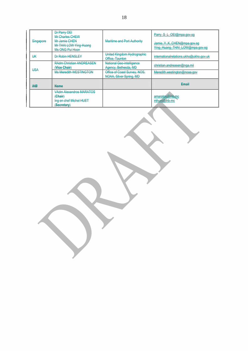
18
Singapore
Dr Parry OEI Mr Charles CHEW Mr Jamie CHEN Mr THAI LOW Ying-Huang Ms ONG Pui Hoon
Maritime and Port Authority
[email protected] [email protected] [email protected]
UK Dr Robin HENSLEY United Kingdom Hydrographic Office, Taunton
USA
RAdm Christian ANDREASEN (Vice Chair)
National Geo-intelligence Agency, Bethesda, MD
Ms Meredith WESTINGTON
Office of Coast Survey, NOS, NOAA, Silver Spring, MD
IHB Name Email
VAdm Alexandros MARATOS (Chair) Ing en chef Michel HUET
(Secretary)
19
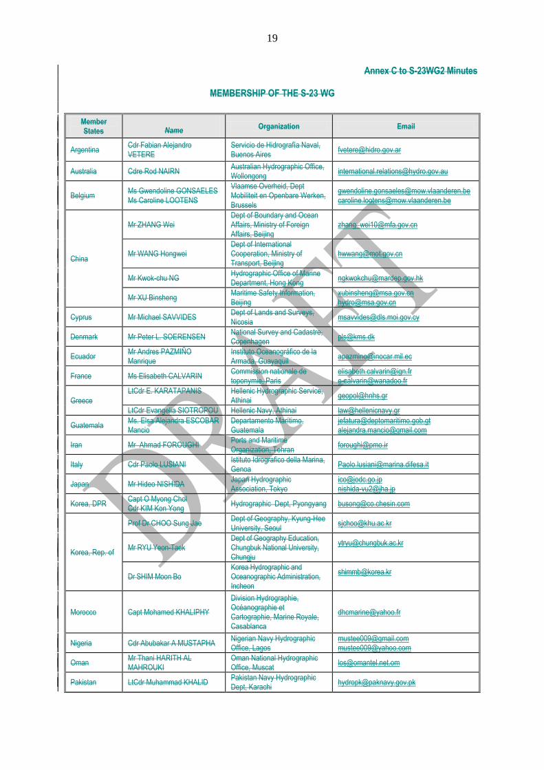
Annex C to S-23WG2 Minutes
MEMBERSHIP OF THE S-23 WG
Member States Name
Organization Email
Argentina Cdr Fabian Alejandro VETERE
Servicio de Hidrografía Naval, Buenos Aires
Australia Cdre Rod NAIRN Australian Hydrographic Office, Wollongong
Belgium Ms Gwendoline GONSAELES Ms Caroline LOOTENS
Vlaamse Overheid, Dept Mobiliteit en Openbare Werken, Brussels
[email protected] [email protected]
China
Mr ZHANG Wei Dept of Boundary and Ocean Affairs, Ministry of Foreign Affairs, Beijing
Mr WANG Hongwei Dept of International Cooperation, Ministry of Transport, Beijing
Mr Kwok-chu NG Hydrographic Office of Marine Department, Hong Kong
Mr XU Binsheng Maritime Safety Information, Beijing
[email protected] [email protected]
Cyprus Mr Michael SAVVIDES Dept of Lands and Surveys, Nicosia
Denmark Mr Peter L. SOERENSEN National Survey and Cadastre, Copenhagen
Ecuador Mr Andres PAZMIÑO Manrique
Instituto Oceanográfico de la Armada, Guayaquil
France Ms Elisabeth CALVARIN Commission nationale de toponymie, Paris
[email protected] [email protected]
Greece
LtCdr E. KARATAPANIS
Hellenic Hydrographic Service, Athinai
LtCdr Evangelia SIOTROPOU Hellenic Navy, Athinai [email protected]
Guatemala Ms. Elsa Alejandra ESCOBAR Mancio
Departamento Marítimo, Guatemala
[email protected] [email protected]
Iran Mr Ahmad FOROUGHI Ports and Maritime Organization, Tehran
Italy Cdr Paolo LUSIANI Istituto Idrografico della Marina, Genoa
Japan Mr Hideo NISHIDA Japan Hydrographic Association, Tokyo
[email protected] [email protected]
Korea, DPR Capt O Myong Chol Cdr KIM Kon Yong
Hydrographic Dept, Pyongyang [email protected]
Korea, Rep. of
Prof Dr CHOO Sung Jae Dept of Geography, Kyung-Hee University, Seoul
Mr RYU Yeon-Taek Dept of Geography Education, Chungbuk National University, Chungju
Dr SHIM Moon Bo Korea Hydrographic and Oceanographic Administration, Incheon
Morocco Capt Mohamed KHALIPHY
Division Hydrographie, Océanographie et Cartographie, Marine Royale, Casablanca
Nigeria Cdr Abubakar A MUSTAPHA Nigerian Navy Hydrographic Office, Lagos
[email protected] [email protected]
Oman Mr Thani HARITH AL MAHROUKI
Oman National Hydrographic Office, Muscat
Pakistan LtCdr Muhammad KHALID Pakistan Navy Hydrographic Dept, Karachi
20
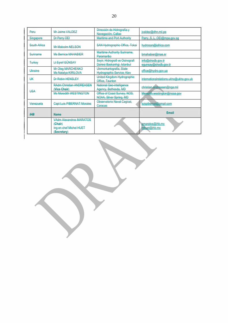
Peru Mr Jaime VALDEZ Dirección de Hidrografía y Navegación, Callao
Singapore Dr Parry OEI Maritime and Port Authority [email protected]
South Africa Mr Malcolm NELSON
SAN Hydrographic Office, Tokai [email protected]
Suriname Ms Bernice MAHABIER Maritime Authority Suriname, Paramaribo
Turkey Lt Eşref GÜNSAY Seyir, Hidrografi ve Osinografi Dairesi Baskanhgi, Istanbul
[email protected] [email protected]
Ukraine Mr Oleg MARCHENKO Ms Natalya KIRILOVA
Ukrmorkartografia, State Hydrographic Service, Kiev
UK Dr Robin HENSLEY United Kingdom Hydrographic Office, Taunton
USA
RAdm Christian ANDREASEN (Vice Chair)
National Geo-intelligence Agency, Bethesda, MD
Ms Meredith WESTINGTON
Office of Coast Survey, NOS, NOAA, Silver Spring, MD
Venezuela Capt Luis PIBERNAT Morales Observatorio Naval Cagical, Caracas
IHB Name Email
VAdm Alexandros MARATOS (Chair) Ing en chef Michel HUET
(Secretary)
Annex D to S-23WG2 Minutes
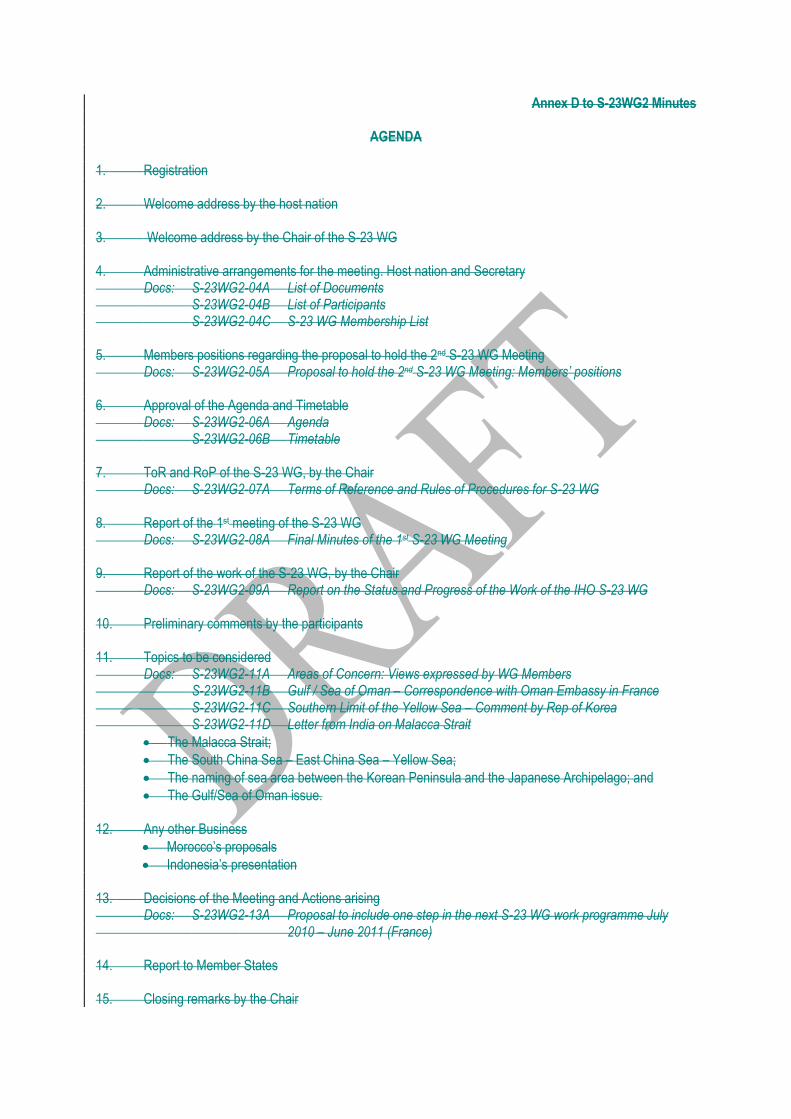
AGENDA 1. Registration 2. Welcome address by the host nation 3. Welcome address by the Chair of the S-23 WG 4. Administrative arrangements for the meeting. Host nation and Secretary Docs: S-23WG2-04A List of Documents S-23WG2-04B List of Participants S-23WG2-04C S-23 WG Membership List 5. Members positions regarding the proposal to hold the 2nd S-23 WG Meeting Docs: S-23WG2-05A Proposal to hold the 2nd S-23 WG Meeting: Members’ positions 6. Approval of the Agenda and Timetable Docs: S-23WG2-06A Agenda S-23WG2-06B Timetable 7. ToR and RoP of the S-23 WG, by the Chair Docs: S-23WG2-07A Terms of Reference and Rules of Procedures for S-23 WG 8. Report of the 1st meeting of the S-23 WG Docs: S-23WG2-08A Final Minutes of the 1st S-23 WG Meeting 9. Report of the work of the S-23 WG, by the Chair Docs: S-23WG2-09A Report on the Status and Progress of the Work of the IHO S-23 WG 10. Preliminary comments by the participants 11. Topics to be considered Docs: S-23WG2-11A Areas of Concern: Views expressed by WG Members S-23WG2-11B Gulf / Sea of Oman – Correspondence with Oman Embassy in France S-23WG2-11C Southern Limit of the Yellow Sea – Comment by Rep of Korea S-23WG2-11D Letter from India on Malacca Strait
The Malacca Strait;
The South China Sea – East China Sea – Yellow Sea;
The naming of sea area between the Korean Peninsula and the Japanese Archipelago; and
The Gulf/Sea of Oman issue. 12. Any other Business
Morocco‟s proposals
Indonesia‟s presentation 13. Decisions of the Meeting and Actions arising Docs: S-23WG2-13A Proposal to include one step in the next S-23 WG work programme July 2010 – June 2011 (France) 14. Report to Member States 15. Closing remarks by the Chair
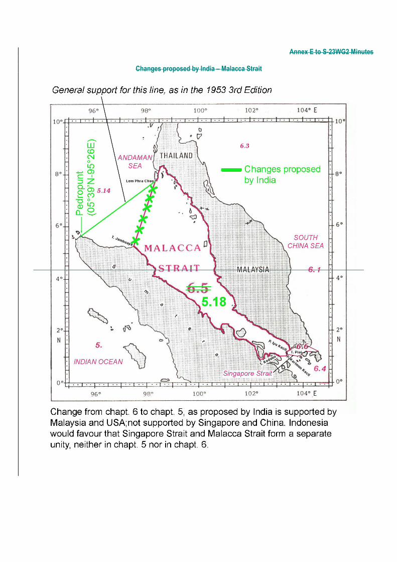
Annex E to S-23WG2 Minutes
Changes proposed by India – Malacca Strait
Annex F to S-23WG2 Minutes
Changes proposed by China – South China Sea and East China Sea
Annex G to S-23WG2 Minutes
Changes proposed by China – Yellow Sea and Bo Hai
Annex H to S-23WG2 Minutes
2nd Meeting of the S-23 WG, Singapore, 5-7 July 2010
Outcomes / Conclusions
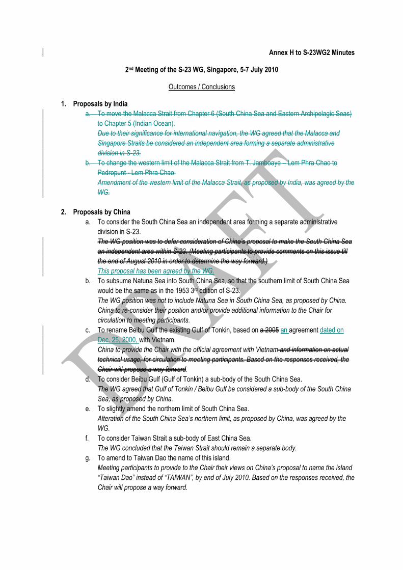
1. Proposals by India
a. To move the Malacca Strait from Chapter 6 (South China Sea and Eastern Archipelagic Seas)
to Chapter 5 (Indian Ocean).
Due to their significance for international navigation, the WG agreed that the Malacca and
Singapore Straits be considered an independent area forming a separate administrative
division in S-23.
b. To change the western limit of the Malacca Strait from T. Jamboaye – Lem Phra Chao to
Pedropunt - Lem Phra Chao.
Amendment of the western limit of the Malacca Strait, as proposed by India, was agreed by the
WG.
2. Proposals by China
a. To consider the South China Sea an independent area forming a separate administrative
division in S-23.
The WG position was to defer consideration of China’s proposal to make the South China Sea
an independent area within S-23. (Meeting participants to provide comments on this issue till
the end of August 2010 in order to determine the way forward.)
This proposal has been agreed by the WG.
b. To subsume Natuna Sea into South China Sea, so that the southern limit of South China Sea
would be the same as in the 1953 3rd edition of S-23.
The WG position was not to include Natuna Sea in South China Sea, as proposed by China.
China to re-consider their position and/or provide additional information to the Chair for
circulation to meeting participants.
c. To rename Beibu Gulf the existing Gulf of Tonkin, based on a 2005 an agreement dated on
Dec. 25, 2000, with Vietnam.
China to provide the Chair with the official agreement with Vietnam and information on actual
technical usage, for circulation to meeting participants. Based on the responses received, the
Chair will propose a way forward.
d. To consider Beibu Gulf (Gulf of Tonkin) a sub-body of the South China Sea.
The WG agreed that Gulf of Tonkin / Beibu Gulf be considered a sub-body of the South China
Sea, as proposed by China.
e. To slightly amend the northern limit of South China Sea.
Alteration of the South China Sea’s northern limit, as proposed by China, was agreed by the
WG.
f. To consider Taiwan Strait a sub-body of East China Sea.
The WG concluded that the Taiwan Strait should remain a separate body.
g. To amend to Taiwan Dao the name of this island.
Meeting participants to provide to the Chair their views on China’s proposal to name the island
“Taiwan Dao” instead of “TAIWAN”, by end of July 2010. Based on the responses received, the
Chair will propose a way forward.
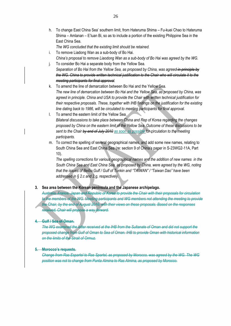
26
h. To change East China Sea‟ southern limit, from Hateruma Shima – Fu-kuei Chao to Hateruma
Shima – Amlanan – E‟luan Bi, so as to include a portion of the existing Philippine Sea in the
East China Sea.
The WG concluded that the existing limit should be retained.
i. To remove Liadong Wan as a sub-body of Bo Hai.
China’s proposal to remove Liaodong Wan as a sub-body of Bo Hai was agreed by the WG.
j. To consider Bo Hai a separate body from the Yellow Sea.
Separation of Bo Hai from the Yellow Sea, as proposed by China, was agreed in principle by
the WG. China to provide written technical justification to the Chair who will circulate it to the
meeting participants for final approval.
k. To amend the line of demarcation between Bo Hai and the Yellow Sea.
The new line of demarcation between Bo Hai and the Yellow Sea, as proposed by China, was
agreed in principle. China and USA to provide the Chair with written technical justification for
their respective proposals. These, together with IHB findings on the justification for the existing
line dating back to 1986, will be circulated to meeting participants for final approval.
l. To amend the eastern limit of the Yellow Sea.
Bilateral discussions to take place between China and Rep of Korea regarding the changes
proposed by China on the eastern limit of the Yellow Sea. Outcome of these discussions to be
sent to the Chair by end of July 2010 as soon as possible for circulation to the meeting
participants.
m. To correct the spelling of several geographical names, and add some new names, relating to
South China Sea and East China Sea (re: section 9 of China‟s paper in S-23WG2-11A, Part
10).
The spelling corrections for various geographical names and the addition of new names in the
South China Sea and East China Sea, as proposed by China, were agreed by the WG, noting
that the issues of Beibu Gulf / Gulf of Tonkin and “TAIWAN” / “Taiwan Dao” have been
addressed in § 2.c and 2.g, respectively.
3. Sea area between the Korean peninsula and the Japanese archipelago.
Australia, France, Japan and Republic of Korea to provide the Chair with their proposals for circulation
to the members of the WG. Meeting participants and WG members not attending the meeting to provide
the Chair, by the end of August 2010, with their views on these proposals. Based on the responses
received, Chair will propose a way forward.
4. Gulf / Sea of Oman.
The WG examined the letter received at the IHB from the Sultanate of Oman and did not support the
proposed change from Gulf of Oman to Sea of Oman. IHB to provide Oman with historical information
on the limits of the Strait of Ormuz.
5. Morocco’s requests.
Change from Ras Espartel to Ras Spartel, as proposed by Morocco, was agreed by the WG. The WG
position was not to change from Punta Almina to Ras Almina, as proposed by Morocco.
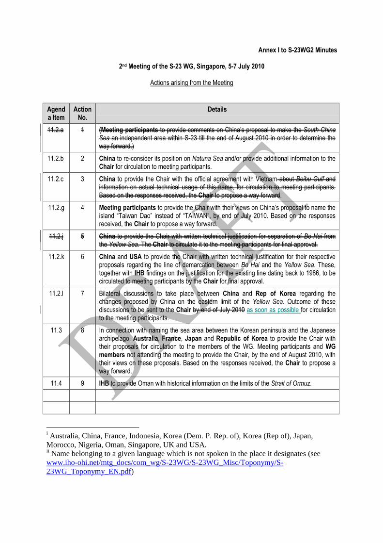
Annex I to S-23WG2 Minutes
2nd Meeting of the S-23 WG, Singapore, 5-7 July 2010
Actions arising from the Meeting
Agenda Item
Action No.
Details
11.2.a 1 (Meeting participants to provide comments on China‟s proposal to make the South China Sea an independent area within S-23 till the end of August 2010 in order to determine the way forward.)
11.2.b 2 China to re-consider its position on Natuna Sea and/or provide additional information to the Chair for circulation to meeting participants.
11.2.c 3 China to provide the Chair with the official agreement with Vietnam about Beibu Gulf and information on actual technical usage of this name, for circulation to meeting participants. Based on the responses received, the Chair to propose a way forward.
11.2.g 4 Meeting participants to provide the Chair with their views on China‟s proposal to name the island “Taiwan Dao” instead of “TAIWAN”, by end of July 2010. Based on the responses received, the Chair to propose a way forward.
11.2.j 5 China to provide the Chair with written technical justification for separation of Bo Hai from the Yellow Sea. The Chair to circulate it to the meeting participants for final approval.
11.2.k 6 China and USA to provide the Chair with written technical justification for their respective proposals regarding the line of demarcation between Bo Hai and the Yellow Sea. These, together with IHB findings on the justification for the existing line dating back to 1986, to be circulated to meeting participants by the Chair for final approval.
11.2.l 7 Bilateral discussions to take place between China and Rep of Korea regarding the changes proposed by China on the eastern limit of the Yellow Sea. Outcome of these discussions to be sent to the Chair by end of July 2010 as soon as possible for circulation to the meeting participants.
11.3 8 In connection with naming the sea area between the Korean peninsula and the Japanese archipelago, Australia, France, Japan and Republic of Korea to provide the Chair with their proposals for circulation to the members of the WG. Meeting participants and WG members not attending the meeting to provide the Chair, by the end of August 2010, with their views on these proposals. Based on the responses received, the Chair to propose a way forward.
11.4 9 IHB to provide Oman with historical information on the limits of the Strait of Ormuz.
i Australia, China, France, Indonesia, Korea (Dem. P. Rep. of), Korea (Rep of), Japan,
Morocco, Nigeria, Oman, Singapore, UK and USA. ii Name belonging to a given language which is not spoken in the place it designates (see
www.iho-ohi.net/mtg_docs/com_wg/S-23WG/S-23WG_Misc/Toponymy/S-
23WG_Toponymy_EN.pdf)