Embed Size (px)
Citation preview
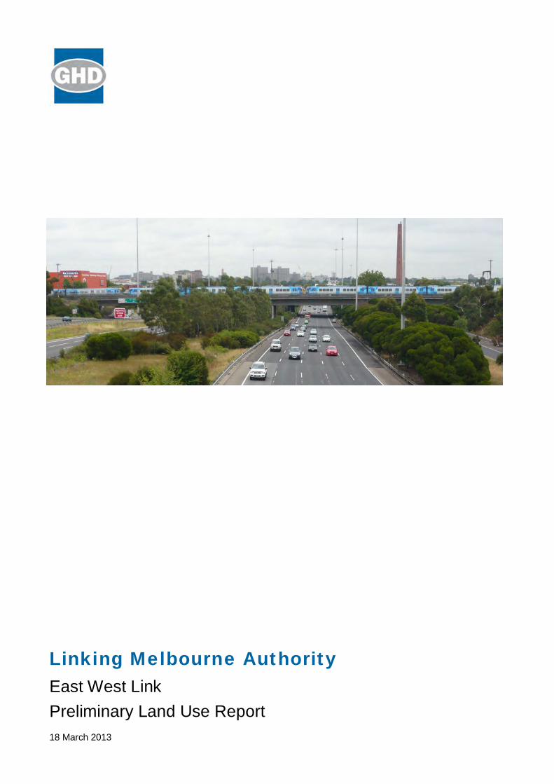
Linking Melbourne Authority East West Link Preliminary Land Use Report 18 March 2013
GHD | Linking Melbourne Authority - Preliminary Land Use Review | i
Table of Contents 1. Introduction ........................................................................................................... 1
1.1 Project Background ..................................................................................... 1 1.2 The Indicative Corridor ................................................................................ 3
2. Existing Conditions: A Snapshot of Current Land Use and Development ................ 6 2.1 Parts A and B of the Indicative Corridor ....................................................... 6 2.2 Overview ..................................................................................................... 6
3. Planning Policy Overview ...................................................................................... 9 3.1 State Planning Policy Framework ................................................................ 9 3.2 Local Planning Policy Framework - Melbourne Planning Scheme................. 9 3.3 Local Planning Policy Framework - Moonee Valley Planning Scheme ........ 10 3.4 Local Planning Policy Framework - Moreland Planning Scheme ................ 10 3.5 Local Planning Policy Framework - Port of Melbourne Planning Scheme ... 10 3.6 Local Planning Policy Framework - Yarra Planning Scheme ...................... 11 3.7 Zones and Overlays .................................................................................. 11 3.8 Particular Provisions .................................................................................. 12
4. Legislation and Policy .......................................................................................... 16 4.1 Commonwealth ......................................................................................... 16 4.2 National ..................................................................................................... 16 4.3 State ......................................................................................................... 16 4.4 Local ......................................................................................................... 18 4.5 Summary ................................................................................................... 24
5. Urban Renewal Opportunities .............................................................................. 25 5.1 Part A ........................................................................................................ 25 5.2 Part B ........................................................................................................ 25
6. Conclusion .......................................................................................................... 27
Table Index Table 1 - Significant Land Use and Development - Part A Indicative Corridor ................... 6
Table 2 - Significant Land Use and Development - Part B Indicative Corridor ................... 6
Table 3 - Zone Controls ................................................................................................. 11
Table 4 - Melbourne Planning Scheme Overlay Controls ............................................... 12
Table 5 - Moonee Valley Planning Scheme Overlay Controls......................................... 12
Table 6 - Moreland Planning Scheme Overlay Controls ................................................. 12
Table 7 - Port of Melbourne Planning Scheme Overlay Controls .................................... 12
Table 8 - Yarra Planning Scheme Overlay Controls ....................................................... 12
ii | GHD | Linking Melbourne Authority - Preliminary Land Use Review
Figure Index Figure 1 - East West Link, Regional Context Plan ............................................................ 4
Figure 2 - East West Link, Eastern Section Indicative Corridor ......................................... 5
Figure 3 - Existing Land Uses of Interest ......................................................................... 8
Figure 4 - Land Use Zoning ........................................................................................... 13
Figure 5 - Land Use Overlays ........................................................................................ 14
Figure 6 - Policy Overview Map ..................................................................................... 20
Appendices Appendix A Planning Scheme Policy Overview
Appendix B Zones and Overlays Overview
GHD | Linking Melbourne Authority - Preliminary Land Use Review | 1
1. Introduction 1.1 Project Background
1.1.1 Purpose and Project Objectives
East West Link, Eastern Section will provide a freeway connection to meet current and future demand for east-west movements across Melbourne.
The project aims to improve the overall productivity and prosperity of Victoria. The proposed East West Link, Eastern Section Project objectives are to:
Enhance the overall efficiency of the transport network, particularly Melbourne and Victorian strategic freeway network;
Improve the capacity and efficiency of Victoria’s freight networks;
Facilitate public transport improvements;
Leverage urban renewal opportunities and improved local amenity;
Provide a freeway connection to meet current and future demand for east west movements across Melbourne;
Provide an alternative to the Westgate - M1 corridor;
Protect and, where possible, enhance natural and cultural resources, and the environment, during the development, delivery and operation of the Project;
Support sustainable communities and land use development during the planning, delivery and operation of the Project; and
Secure timely delivery of the Project.
1.1.2 Strategic Context and Project Need
East West Link is a proposed cross city road connection linking the Eastern Freeway at Hoddle Street to the Western Ring Road in Sunshine West, a total length of approximately 18 kilometres.
The project was identified in Sir Rod Eddington’s East West Link Needs Assessment Report (EWLNA) in 2008 and is being proposed for a variety of reasons, particularly to:
overcome poor east-west road connections.
ease congestion on existing cross city routes.
reduce Melbourne’s over-reliance on the Monash:CityLink:West Gate (M1).
service the growing volumes of freight moving through the Port of Melbourne.
There is a strong and growing demand for east-west trips north of the central business district, with around 210,000 vehicles trips per day currently taken along existing routes.
The EWLNA highlighted that current east-west routes in this area are disconnected and often include inappropriate suburban streets. It found that around 40 per cent of daily in-bound traffic on the Eastern Freeway is destined to areas beyond the central city area, including to other arterial road connections in the south and west of metropolitan Melbourne.
The Eddington Report discussed options for upgrading Melbourne’s future road network, in order to ease traffic congestion and facilitate freight mobility. It concluded that without taking action to improve cross city connections, there would be much higher levels of congestion on the city’s major east-west
2 | GHD | Linking Melbourne Authority - Preliminary Land Use Review
arterial routes, generating additional costs for businesses and causing unreliable and slow travel times.
The Eastern section of the East West Link would complete a missing link in the metropolitan freeway network between the Eastern Freeway and CityLink, and further onto the Port of Melbourne precinct. It would contribute to improved east-west cross city traffic flow by meeting the demand for cross city travel, which is forecast to increase significantly over the next 25 years, and alleviating the congestion bottleneck where the Eastern Freeway terminates abruptly and joins with Alexandra Parade. It would cater for forecast future freight growth and provide a much needed alternative to the M1, Melbourne’s only high-capacity, east-west road connection.
The project is proposed to be constructed using a variety of methods to reduce community impacts, including some tunnel sections. The Eastern section offers the opportunity for significant amenity benefits to the local community by contributing to a reduction in traffic from the local street network and potentially freeing up road space for walking, cycling and public transport activity,. The project would contribute to urban renewal opportunities in a location well serviced by social and community infrastructure.
The East West Link underpins key drivers of the Victorian Government’s Metropolitan Planning Strategy (currently under preparation), which seeks to manage Melbourne’s growth as it moves beyond a city of four million people, through an integrated sustainable urban development and transport vision . The Discussion Paper , Melbourne, let’s talk about the future, prepared by the Ministerial Advisory Committee for the Metropolitan Planning Strategy for Melbourne (October 2012), reinforces the key city shaping role East West Link would play in catering for population and economic growth, improving road capacity, freight efficiency and liveability and enhancing Victoria’s global competitiveness.
The project also seeks to respond to the Department of Transport’s (DOT) Transport Solutions strategy (under preparation), which would act as a framework to promote efficient industry supply chains that aim to boost the productivity of Victorian industry and enhance regional growth by removing congestion in the road, rail and port networks. Transport Solutions would work to strengthen partnerships between government and industry, encourage growth in exports, support industry, economic and population growth in regional Victoria, and facilitate both government and private sector investment.
Improvements to city, ports and airports access would enable the central city to intensify and expand to the north, west and south. Improvements to public transport and local amenity in the corridor would provide opportunities to leverage targeted urban renewal and provide greater housing choice and affordability.
1.1.3 Project Components
Key sections of the Project include:
Part A: Eastern Freeway to CityLink (Tullamarine Freeway).
Part B: CityLink to the Port area where it would interface with WestLink.
Both Part A and Part B could comprise a combination of: tunnels, bridges, elevated roads and surface road connections. Part A and Part B may be delivered in separate stages with Part A capable of being developed independently of Part B.
Parts A and B of the project along with the western section of East West Link (known as WestLink) are presented in Figure 1 - Regional Context Plan.
GHD | Linking Melbourne Authority - Preliminary Land Use Review | 3
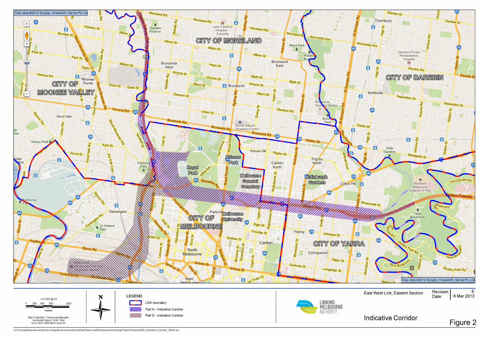
1.2 The Indicative Corridor
The indicative corridor subject of this report is outlined in Figure 2. The corridor comprises two parts, being Part A and Part B.
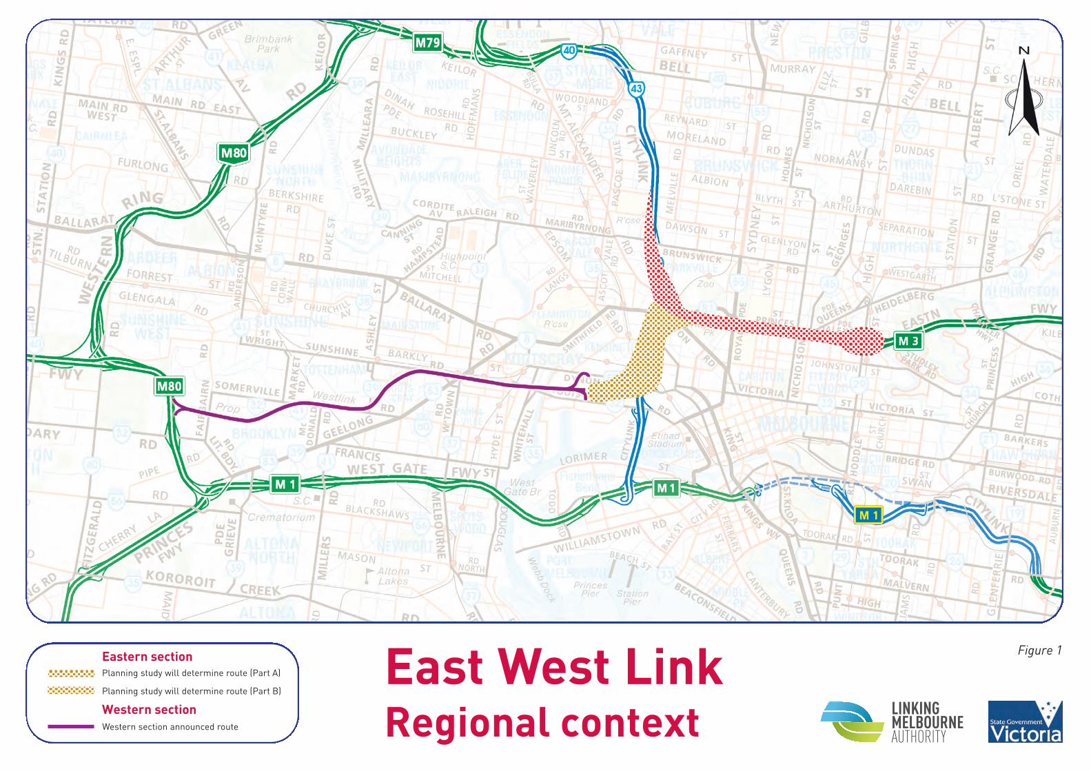
East West LinkRegional context
Planning study will determine route (Part A)
Planning study will determine route (Part B)
Western section announced route
Eastern section
Western section
Figure 1
6 | GHD | Linking Melbourne Authority - Preliminary Land Use Review
2. Existing Conditions: A Snapshot of Current Land Use and Development
2.1 Parts A and B of the Indicative Corridor
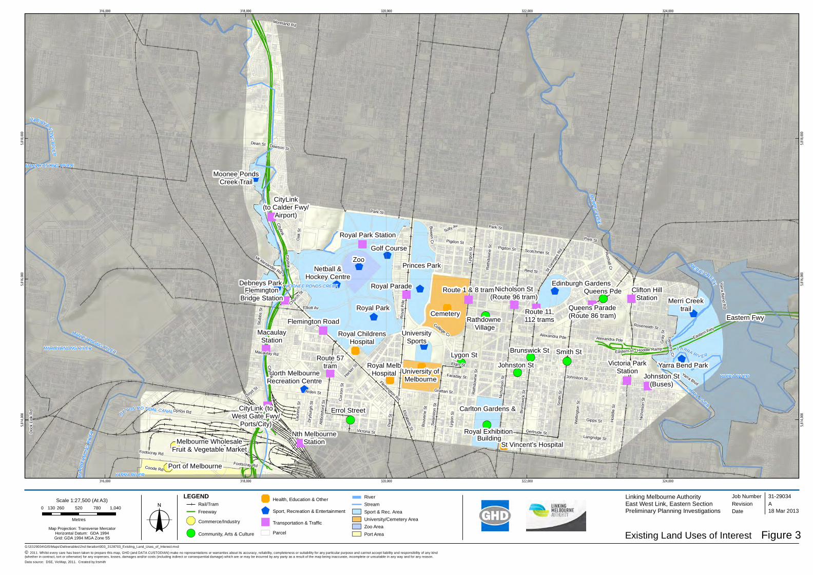
Table 1 identifies significant land uses either within or proximate to Part A of the indicative corridor (refer to Figure 3 for a graphic illustration).
Table 1 - Significant Land Use and Development - Part A Indicative Corridor
Melbourne Zoo Princes & Royal Parks
Royal Melbourne Hospital Melbourne General Cemetery
Edinburgh Gardens Yarra Bend Park
Clifton Hill, Victoria Park and Royal Park Train Stations
Merri Creek Trail
State Netball and Hockey Centre Railway / Tram lines and associated infrastructure
The University of Melbourne Key Arterials (Royal Parade, Lygon Street, Nicholson Street, St Georges Road, Queens Parade, Brunswick Street and Smith Street)
Moonee Ponds Creek Trail Moonee Valley Racecourse
Table 2 identifies notable land uses within or proximate to Part B of the indicative corridor (refer to Figure 3).
Table 2 - Significant Land Use and Development - Part B Indicative Corridor
North Melbourne Recreation Centre CityLink, Flemington Road
North Melbourne Rail Station / Railway line
Tram lines / Associated infrastructure
Flemington Bridge and Macaulay Train Stations
North Melbourne Cricket Ground / Community sports facilities
Melbourne Wholesale Fruit and Vegetable Market
Port of Melbourne Environs
Debneys Park
2.2 Overview
A number of land use ‘themes’ emerge across Part A and B of the indicative corridor area that can be categorised across Residential, Sports / Recreation, Health / Education, Community / Arts / Culture and Employment / Industry. A more detailed overview follows:
GHD | Linking Melbourne Authority - Preliminary Land Use Review | 7
2.2.1 Residential
The indicative corridor either encompasses or is proximate to a significant residential catchment across the established suburbs of Abbotsford, Carlton / Carlton North, Collingwood, Clifton Hill, Fitzroy / Fitzroy North, Flemington, Kensington, North Melbourne and Parkville. These areas are also interspersed with elements of mixed use activity that contributes to a sense of vibrancy.
Significant heritage built form is a contributing feature to the character of the wider area.
2.2.2 Sport / Recreation
Significant sport facilities and recreational opportunities are available within the vicinity of the indicative corridor, including the informal parkland along the Yarra River / Merri Creek and Moonee Ponds Creek environs, Princes and Royal Parks and the Edinburgh Gardens. Sporting facilities are generally located towards the western end of the investigation area and these include the Royal Park Golf Course, State Netball and Hockey Centre, Princes Park Football Oval and the North Melbourne Cricket ground. Moonee Valley Racecourse is located on the western side of CityLink in Moonee Ponds. These facilities provide a significant recreation resource to both the local and wider population.
2.2.3 Health / Education
The University of Melbourne and both the Royal Children’s and Royal Melbourne Hospitals are State significant institutions located within or to the south of the indicative corridor. A number of State and Private primary and secondary schools also contribute to defining education and health precincts.
2.2.4 Community / Arts / Culture
A wide range of community and culturally significant land uses are located across the indicative corridor (or close by) from Melbourne Zoo within Royal Park, to the numerous ‘café precincts’ in Carlton, Clifton Hill, Collingwood and North Melbourne. The Melbourne General Cemetery is a significant presence in Carlton North.
These are all important cultural and tourism opportunities that make significant contributions to diverse and vibrant land use which are recognised accordingly by the City of Melbourne and City of Yarra.
2.2.5 Employment / Industry
The University of Melbourne serves as a significant employer across the academic and research fields.
Largely focussed towards the south-western end of the indicative corridor (Part B), mixed use and industrial activity exists that plays a contributing role to both Regional and Local employment opportunity.
Royal Park Station
CityLink(to Calder Fwy/
Airport)
Royal Park
Royal ChildrensHospital
CityLink (toWest Gate Fwy/
Ports/City)
University ofMelbourne
Princes Park
Royal Parade Edinburgh Gardens
ZooNetball &
Hockey Centre
Flemington Road
FlemingtonBridge Station
North MelbourneRecreation Centre
Cemetery
Route 1 & 8 trams
Rathdowne Village
Clifton HillStation
Victoria ParkStation
Johnston St(Buses)
Merri Creektrail
Yarra Bend Park
Queens Parade(Route 86 tram)
Smith StBrunswick StLygon St
Nicholson St(Route 96 tram)
Route 11,112 trams
UniversitySports
Royal MelbHospital
Errol Street
Nth MelbourneStation
Route 57tram
MacaulayStation
Eastern Fwy
Johnston St
Golf Course
Queens Pde
Dawson St
Citylink
Melbourne WholesaleFruit & Vegetable Market
Port of Melbourne
Carlton Gardens &
Royal ExhibitionBuilding
St Vincent's Hospital
Moonee PondsCreek Trail
Debneys Park
Moreland Rd
Yarra Blvd
Hod
dle
St
Dynon Rd
Nic
hols
on S
t
Roy
al P
de
Footscray Rd
Flemington Rd
Elliott Av
Cur
zon
St
Peel
St
Elizabeth St
St G
eorg
es R
d
Dry
burg
h St
Alexandra PdeHar
ker S
t
College Cr
Footscray Rd
Smith
St
Lygo
n S
t
Arden St
Johnston St
Grattan St Rat
hdow
ne S
t
Elgin St
Swan
ston
St
Brun
swic
k S
t
Lloyd St
Gertrude St
Stub
bs S
t
Victoria St
Dean St
Mt Alexander Rd
Macaulay Rd
Park St
Wel
lingt
on S
t
Oak
St
Lygo
n S
t
Gipps StAbbo
tsfo
rd S
t
Rat
hdow
ne S
t
Coode Rd
Yarra Bend R
d
Scotchmer StPigdon St
Langridge St
Trenerry Cr
Bouv
erie
St
Laur
ens
St
Reid St
Rushall Cr
Faraday St
Nic
hols
on S
t
Roseneath St
Bowen C
r
Solly Av
Gra
y S
t
Church
St
Pigdon StPark St
Park St
Alexandra Pde
Citylink
Eastern Fwy
Eastern In - Hoddle Ramp
Citylink
MERRI CREEK
YARRA RIV ER
MARI
BYRN
ONG
RIVE
R
DYNON RD TIDAL CANAL
MARIBYRNONGRIVER
MERRI CREEK
YARRA RIVER
MARIBYRNONG RIVER
YARRA RIVER
MARIBYRNONG RIVER
MOONEE PONDS CREEK
MARIBYRNONG RIVER
YARRA RIVER
316,000
316,000
318,000
318,000
320,000
320,000
322,000
322,000
324,000
324,000
5,814,
000
5,814,
000
5,816,
000
5,816,
000
5,818,
000
5,818,
000
G:\31\29034\GIS\Maps\Deliverables\2nd Iteration\003_3128703_Existing_Land_Uses_of_Interest.mxd
© 2011. Whilst every care has been taken to prepare this map, GHD (and DATA CUSTODIAN) make no representations or warranties about its accuracy, reliability, completeness or suitability for any particular purpose and cannot accept liability and responsibility of any kind (whether in contract, tort or otherwise) for any expenses, losses, damages and/or costs (including indirect or consequential damage) which are or may be incurred by any party as a result of the map being inaccurate, incomplete or unsuitable in any way and for any reason.
0 260 520 780 1,040130
Metres
Map Projection: Transverse MercatorHorizontal Datum: GDA 1994Grid: GDA 1994 MGA Zone 55 Figure 3
Job NumberRevision A
31-29034
18 Mar 2013
Existing Land Uses of Interesto Date
Data source: DSE, VicMap, 2011. Created by:lrsmith
Scale 1:27,500 (At A3)Rail/TramFreeway
&- Commerce/Industry
!( Community, Arts & Culture
' Health, Education & Other
$ Sport, Recreation & Entertainment
" Transportation & Traffic
Parcel
RiverStreamSport & Rec. AreaUniversity/Cemetery AreaZoo AreaPort Area
LEGEND
Doc
k Li
nk R
d
Linking Melbourne AuthorityEast West Link, Eastern SectionPreliminary Planning Investigations