Embed Size (px)
Citation preview
SUSITNA . HYDROELECTRIC PROJECT • FEDERAL ENERGY REGULATORY COMMISSION · PROJECT No. 7114 i
SITY OF ALASKA ·~
....
Dn.: , .A·. rT· i\t1f
CULTURAL RESOURCES INVESTIGATIONS
1979-1985 . VOLUMEJ[
APPENDICES 8 and C
MAY 1985 DOCUMENT No. 2 713
ASiKA POWER AUTHORITY _____ ____.
SUSITNA HYDROELECTRIC PROJECT
CULTURAL RESOURCES INVESTIGAT~ONS
1979 - 1985
VOLUME II
APPENDICES B AND C
Report by University of Alaska Museum
D:>CU!Dent No. 2713
E. James Dixon, Ph.D. Pri'.ncipal Investigator
George S. Smith, M.A. Project Supervisor
William Andrefsky, Ph.D. Arc~haeologist
Charles J. Utennohle, Ph.D. Arc~haeo logi st
Becky M. Saleeby, Ph.D. Archaeologist
Prepared for Alaska Power Authority
May 1985
APPENDIX B - SURVEY LOCALE FORM, SITE SURVEY FORM, FIELD NOTEBOOK GUIDES,
AND SITE DATA FORM
Page
TABLE OF CONTENTS
LIST OF FIGURES •••••.•••••••••••••••••••••.•••••••••.••.••••• B-i i i
B.1 - Survey Locale Form •.••.••...•...•..••.•••......•..•..... 8-1
B.2 - SitE! Survey Form •...••.•..•..••.•..•..••...••......••••• B-5
B.3 - Field Notebook Guidelines Section B-13
8.4 - Site! Data Coding Form •.•.••.••..•..••••••..••..•..••..• B-41
B- i
LIST OF FIGURES
Page
Fi gu re B. 3. l.Figure B.3.2.Figure B.3.3.
Fi gu re B. 3.4.
Figure B.3.5.Figure 8.3.6.
Figure.B.3.7.Figure 8.3.8.
Figure B.3.9.Figure B.3.10.Figure B.3.11.F; gu re B. 3. 12 .Figure B.3.13.
Figure 8.3.14.Figure 8.3.15.
Figure 8.3.16.Figure 8.3.17.
Figure 8.3.18.
Figure 8.3.19.Figure 8.3.20.
Figure 8.3.21.
Figure 8.3.22.Figure 8.3.23.Figure 8.3.24.
Figure 8.3.25.
Figure 8.3.26.
Figure 8.3.27.
Example of Index in Field Notebooks .Example of Narrative Format Page .
Example of Shovel Test Expansion with SingleShovel Test with Cultural Material .
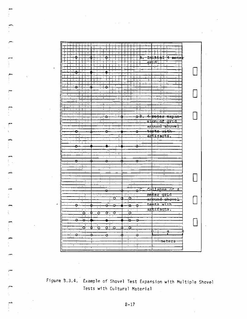
Example of Shovel Test Expansion withMultiple Shovel Tests with Cultural Material
Format for Test Pit Profile ..
Symbols Used for Survey Site Map .
Mapping Notes Format .Mappi ng Notes Symbo 1s .
Example of Mapping Notes .......•..............Square Placement and Elevations Format .Plan Map Format .
Symbols Used on Plan Map .
Artifact Description Format .
Artifact Description Guidelines .
Artifact Description Guidelines
Cant i n·ue·d .
C-14 Sample Recording Format .C-14 Sample Recording Guidelines .
Soil/Sediment Description Format .
Symbols Used for Wall Profiles .Soil/Sediment Description Guidel ines .Soil/Sediment Description Guidelines
Continued .Photo Log Format .Checklist for Survey Locale Data Sheets .Checklist for Site Data Sheets(Survey Testing) ..•.. 0 ••••••••••••••••••••••••••
Checklist for Site Data Sheets(Systematic Testing) .Checklist for Test Square Data Sheets .Checklist for Profiles and Soil/SedimentDescri pti ons .
8- i i
8-148-15
8-16
8-178-188-198-208-21
8-228-238-248-258-268-27
8-28
8-298-30
8-318-328-33
8-348-358-36
8-37
8-388-39
8-40
-
B.1 - SURVEY LOCALE FORM
B-1
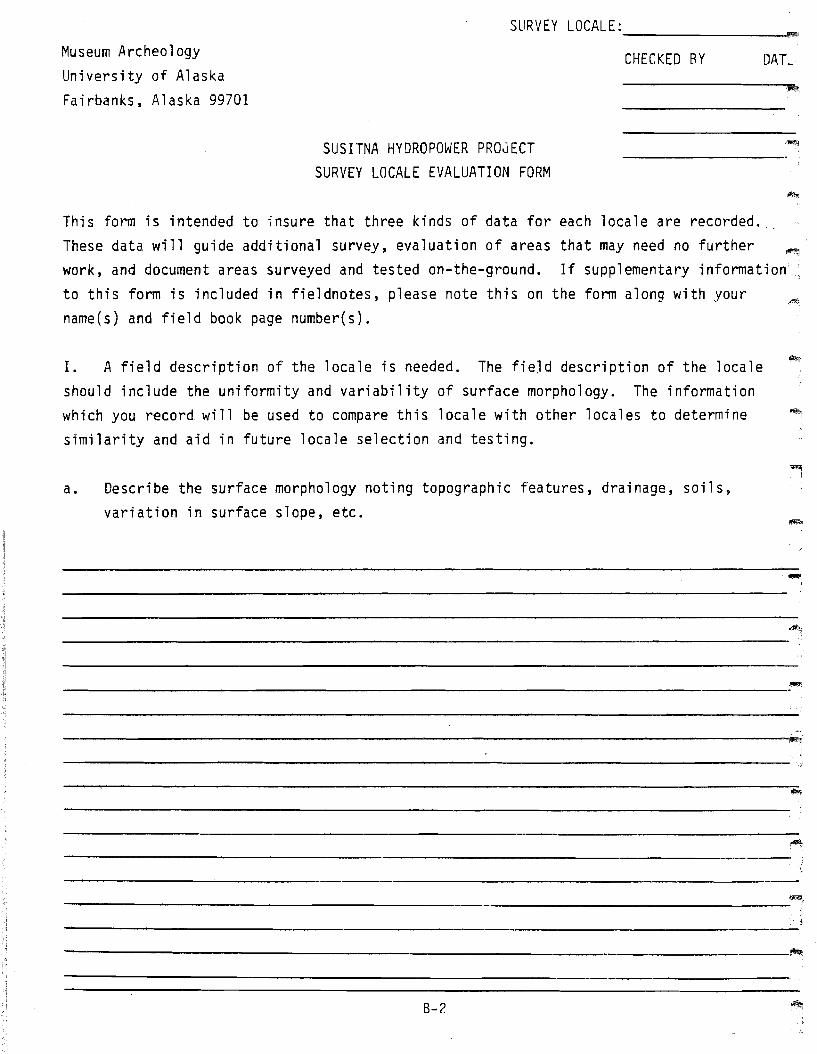
SURVEY LOCALE:--------_l!I'l!iMuseum ArcheologyUniversity of AlaskaFairbanks, Alaska 99701
SUSITNA HYDROPOWER PROJECTSURVEY LOCALE EVALUATION FORM
CHECKED BY DAL'
~,
-This form is intended to insure that three kinds of data for each locale are recorded.These data will guide additional survey, evaluation of areas that may need no furtherwork, and document areas surveyed and tested on-the-ground. If supplementary informationto this form is included in fieldnotes, please note this on the form along with yourname(s) and field book page number(s).
I. A field description of the locale is needed. The fieJd description of the localeshould include the uniformity and variability of surface morphology. The informationwhich you record will be used to compare this locale with other locales to determinesimilarity and aid in future locale selection and testing.
a. Describe the surface morphology noting topographic features, drainage, soils,variation in surface slope, etc.
"""iI
---------------------------------------~
---------------------------------------_.
---------------------------------------~
B-?
b. What, if any, are the discrepancies between the definition of the geological unit
(based on air photo interpretation) and the field observation of the unit? Would you
characterize the total area as a single unit based on the homogeneity of surface
morphology?
,'i"""
II. Identify areas within the locale that potentially may be eliminated from further
archeological survey. Please provide objective criteria in your evaluation such as:1) areas where testing is not feasible using standard archeological field techniques
(areas of standing water, talus rubble); 2) areas where the substrata have been removedby natural erosion (indicate whether these areas have been surface examined forarcheological materials); and 3) overly steep slopes. This would include slopes of greater than
15 0 to horizontal ~Ihich you deem unlikely for site occurrence (describe and measure slopeangle).
B-3
III. Identify areas within the locale which may have high archeological potential, basedon known site locales from other areas and your field experience, including overlooks,river terrace and bluff edges, lake and stream margins, etc. Describe the location,extent, salient features, and tests (if applicable) for these locales, record theselocations on USGS maps.
------------------------------.;.-----------,-
High archeological potential areas that should be investigated
-------------------------------------------:~
IV. Locate on maps where the survey team actually went on-the-ground, and location,number, size, and depth of test pits excavated and natural exposures examined. Describethe topographic setting, and relation to other physical features, such as lakes, streams,rivers, bluff, edges, nearby hills, elevation, etc., for sterile test pits.
------------------------------------------:.
_S_i_t.....es_f_o_u_n_d_i_n_l_o_c_a_l....;.e_: ~
Number of shovel tests --
-NAMES OF FIELD TEAM: (include relevant pages in fieldbook)
Date------------ -----____________ Date _
Date------------ -----Date------------ ------____________ Date _
____________ Date _
Date------------ -----,Date------------ ------Date ~,------------ -----Date------------ ------Date .~------------ ----...-...,
_ Date _
8-4
B.2 - SITE SURVEY FORM
B-5
ARCHEOLOGYUNIVERSITY MUSEUMUNIVERSITY OF ALASKA
AHRS NO.:--------SURVEY LOCALE NO.:--------
UA NO.:--------
SUSITNA HYDROPOWER PROJECTCHECKED BY DATE--------.-
IIo
SITE LOCATIONA. USGS QUAD: Talkeetna Mountains Scale: 1:63,360B. AIR PHOTO REFERENCE: Roll Frames ___C. TWP , RNG , Seward Meridian
! of the ! of the of Section----- ------D. UTM: Zone 6 Easting Northing """.Eo LATITUDE: 0 II LONGITUDE:F. GEOLOGICAL UNIT: No. _
G. REGION: Devi 1 Canyon Watana Other:------ ----------
I.
II. ENVIRONMENT:A. Site morphology. (See back of form for information required.)
-
-------------------------------------~
_____________________________________ iom
B. Surrounding terrain morphology. (See back of form for information required.) -
------------------------------------~
---------------------.;.----------------""'"'B-6
AHRS NO.:---------
Ecosystem.Other:---
Upland spruce-hardwood---
(See back of sheet for descriptions.)_______ Moist Tundra High Brush_______ Lowland spruce-hardwood
1.
c.
2. Site vegetation and surface description:
3. Vegetation in surrounding area and surface description:
...,.
B-7
II 1. SITE:
A. Descr"iption:
1. Characteristics.
AHRS NO.:---------
(lithic scatter, stratified site, cabin, etc.)
______________________________________-"""l1!
number of shovel tests
2.
number of test pits(indicate on map)
Number, size and spatial relationship of features, etc....
---------------------------------------,iIl'""
~.-------------------------------------------------------------------------------,.,
3. Stratigraphy (if relevant):
---------------------------------------_.,
8-8
B. Artifact inventory.1. Surface:
a. Artifacts collected:
b. Artifacts observed but not collected:
2. Systematically excavated artifacts:
c. Period: Unknown--Historic:--
Precontact--Native Non-Native --
",....",
r,,"
D. Size:1. Observed Size: x meters
Justification for boundaries:
2. Estimated Size: x metersJustification for boundaries:
E. Site disturbance (current and anticipated). Indicate expected effect of thehydroelectric project on the site.1. Natural:-------------------------------
2. Human:------------~-----------------
8-9
AHRS NO.---------F. What prompted you to survey this location?
G. Draw and attach map(s) of site with location of tests and surface features; soi'profile(s); and general location and vegetation map.
IV. PHOTOGRAPHIC RECORD:Frame # Direction
Roll#--Content
Site 10 with date and Crew
---------------------------'~
-----------------------------:-
--------------------------~.
CREW:A.
v. (include relevant pages in fieldbook)Names: -
B. Date(s) visited: ----------------------------VI. Field Recommendation for further testing:
----------------------------------------
---------------------B--I-0------------------~·
1.
I1. A.
11. B.
Site morphology.
1. What terrain feature is the site on: flat plain, sloping plain, continuousridge, hill, point, shoreline, terrace, valley, etc.
2. What is the topographic context:a. no topographic relief relative to surrounding terrain, higher topo
graphic relief than surrounding terrain, lower topographic relief thansurrounding terrain.
b. give elevation: 1) above sea level; 2) Relative to surrounding terrain.3. Is the terrain feature continuous or discrete?4. What is the size, shape and direction of this feature?5. What is the relative position of the site on this feature?6. Field of view:
a. direction and range of view;b. what is in view?c. would a change in the present vegetation increase or decrease view?
How?7. Describe any special attributes that make this site location unique.8. Are there other settings similar to that of this site in the unit? Where?
Surrounding terrain morphology.
Describe surrounding landforms and water features' in relation to the site. Whatis the direction, distance and difference in elevation of surrounding features?The following characteristics should provide a guide:
Streams and rivers:a. proximity to siteb. access from sitec. are any in view from site?d. has downcutting created valley wall constriction in this area?e. is stream or river (I) shallow with rapids and sandbars, or (2) deep
and smooth in this vicinity, etc:.f. is water clear or turbid?g. what is the general width in this vicinity?h. is terracing present?i. in this area is the river course:
1. straight;2. bending;3. serpentine.
j. are confluences with other streams or rivers nearby? How far?k. what kind of terrain does this stream or river drain? (lakes, hills,
marsh)
2. Lakes:a. size in hectares using template.b. inlet present? outlet present?c. single lake or part of lake system?d. characterize terrain surrounding lake (low, wet, steep, etc.)e. is there any evidence that lake size is changing (vegetation overgrowth,
old shorelines, etc.) .f. cha;acteristics of shoreline. Old shorelines present?
B-l1
-
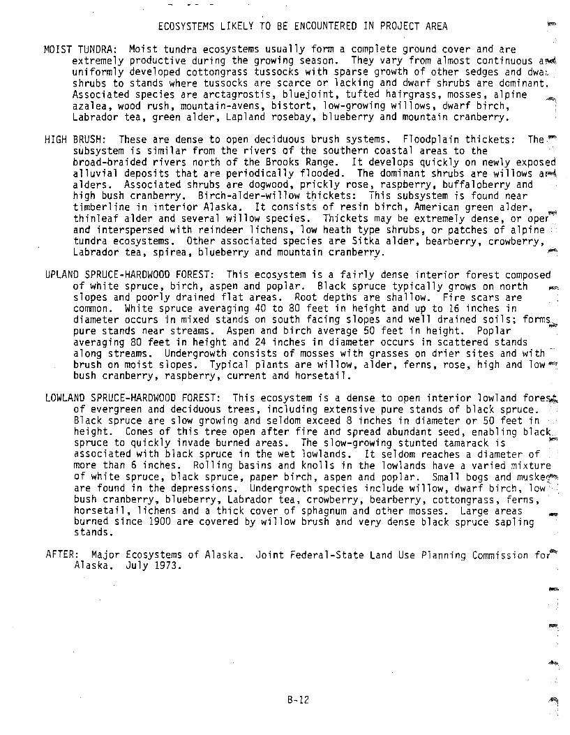
ECOSYSTEMS LIKELY TO BE ENCOUNTERED IN PROJECT AREA
MOIST TUNDRA: Moist tundra ecosystems usually form a complete ground cover and areextremely productive during the growing season. They vary from almost continuous a~
uniformly developed cottongrass tussocks with sparse growth of other sedges and dwa~
shrubs to stands where tussocks are scarce or lacking and dwarf shrubs are dominant.Associated species are arctagrostis, bluejoint, tufted hairgrass, mosses, alpineazalea, wood rush, mountain-avens, bistort, low-growing willows, dwarf birch,Labrador tea, green alder, Lapland rosebay, blueberry and mountain cranberry.
HIGH BRUSH: These are dense to open deciduous brush systems. Floodplain thickets: The~
subsystem is similar from the rivers of the southern coastal areas to thebroad-braided rivers north of the Brooks Range. It develops quickly on newly exposedalluvial deposits that are periodically flooded. The dominant shrubs are willows a~.
alders. Associated shrubs are dogwood, prickly rose, raspberry, buffaloberry andhigh bush cranberry. Birch-alder-willow thickets: This subsystem is found neartimberline in interior Alaska. It consists of resin birch, American green alder, ~.
thinleaf alder and several willow species. Thickets may be extremely dense, or oper·and interspersed with reindeer lichens, low heath type shrubs, or patches of alpinetundra ecosystems. Other associated species are Sitka alder, bearberry, crowberry,Labrador tea, spirea, blueberry and mountain cranberry. ~
UPLAND SPRUCE-HARDWOOD FOREST: This ecosystem is a fairly dense interior forest composedof white spruce, birch, aspen and poplar. Black spruce typically grows on north ~
slopes and poorly drained flat areas. Root depths are shallow. Fire scars areCOlruTIOn. Wh ite spruce averagi ng 40 to 80 feet in hei ght and up to 16 inches indiameter occurs in mixed stands on south facing slopes and well drained soils; forms~
pure stands near streams. Aspen and birch average 50 feet in height. Poplaraveraging 80 feet in height and 24 inches in diameter occurs in scattered standsalong streams. Undergrowth cons ists of mosses with grasses on dri er sites and wi th brush on moist slopes. Typical plants are willow, alder, ferns, rose, high and lowbush cranberry, raspberry, current and horsetail.
LOWLAND SPRUCE-HARDWOOD FOREST: This ecosystem is a dense to open interior lowland fore~
of evergreen and deciduous trees, including extensive pure stands of black spruce.Black spruce are slow growing and seldom exceed 8 inches in diameter or 50 feet inheight. Cones of this tree open after fire and spread abundant seed, enabling black_spruce to quickly invade burned areas. The slow-growing stunted tamarack is ~associated with black spruce in the wet lowlands. It seldom reaches a diameter ofmore than 6 inches. Rolling basins and knolls in the lowlands have a varied mixtureof white spruce, black spruce, paper birch, aspen and poplar. Small bogs and muske~j
are found in the depressions. Undergrowth species include willow, dwarf birch, low·bush cranberry, blueberry, Labrador tea, crowberry, bearberry, cottongrass, ferns,horsetail, lichens and a thick cover of sphagnum and other mosses. Large areasburned since 1900 are covered by willow brush and very dense black spruce saplingstands.
AFTER: Major Ecosystems of Alaska. Joint Federal-State Land Use Planning Commission faAlaska. July 1973.
B-12
B.3 - FIELD NOTEBOOK GUIDELINES SECTION
B-13
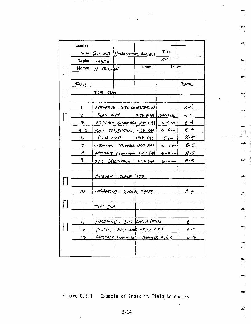
D
Locale/
Site:
Topic:
Uame:
i
Test: ilevel: I
~,
P"I
"""!.I I I· i\ }J~';~ -~~ Oi-teurwn--ow--+I-----:-l-f3---{--1
z3
4-5
I ; I 1__1__-1
___I d4/2.~j t.<J~ f 121! I
I I I I !o
oo
o~....;.I_O_IIJId2i2AnJc' 1;uovk.. '1esrs I I
I i I 'I II i
IT~M uA I I I
o 11
12
8-1"
Figure 8.3.1. Example of Index in Field Notebooks
8-14
Locale' '5. L . I,;~I
Site:
o Hame: "'5. .s~q
Level: II
-oo
I
o!
I
I I I· I I___....;l~ ' ------~--------l
I I I i, 1! I
o
Figure 8.3.2. Example of Narrative Format Page
8-15
o1_,..
! InISI, I i1 I I I 'T, 11..,I n_•••_
, I
, !
I I I I II ,I I ,
I 1I I ,
, I
, I
I I 1, I
i' 'II I j I
I I
I I
I
1 I, ft....a-.. i
1 I
I
:::a::
I.
, I
PIlUtl i1 I I
, 1
I I 1 I I
I I
-
DI I
I
I 1
1 I
I '
I I
I I
, I
1
i'!.; J.Il.l. .4 I'£.j , I-. I 1"'11
,"" ""l' ";'.ur; j-'h' ......+ -F .. ,..iO""
, I
o I !
, ;
I, , J
I '
: 'I I ~ t
i I ! I I ,I
I I 'i
I 'I I
!
! I
I r
! ;I ! ,1lI!'ll\
D.1:). UJ.. ...
"..::I' . -'1. ,':I
j-pq1-' wi fh .. ,...+; -F~,..+-,",
- -.
0~
U
0 -
1---+--1---$= --~~~.~
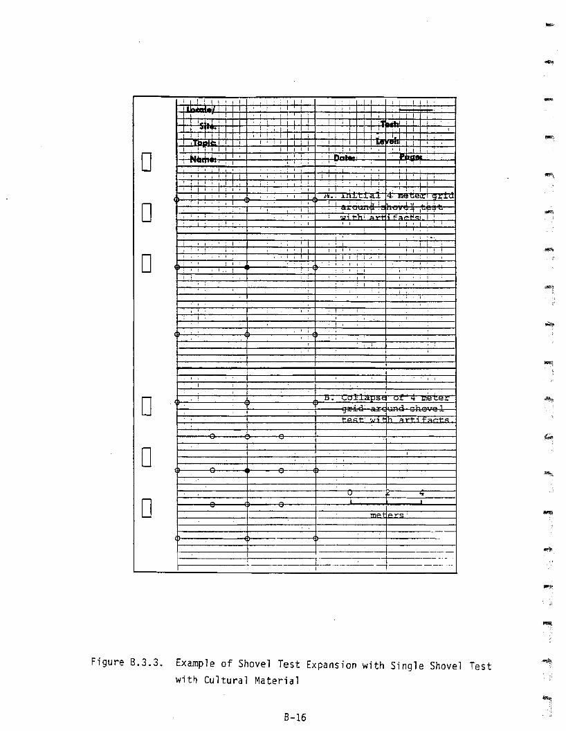
Figure 8.3.3. Example of Shovel Test Expansion with Single Shovel Testwith Cultural Material
8-16
Mu It i p1e ShovelwithTest Expans ion
Material
Shovel
Cu ltura 1
Example of
Tests with
8.3.4.Figure
B-17
I I I
I I i
I I I I
.....I I I I! I ,I
I I
oo ! I
• .-:1
, i
I I
. I
I l !I I
i I
. - .
I10'1:
it!• I
1 I I
1
I I
I ,
f 1 I J
I I, !
I I
I !: I I
I I ~"'I"'.' I1 I 1
j I I I I
I II I I l
I I I
I I
, I
I •.
I •
I 'I I l
I I
: '! i
I I I
1.!A,w I'I , ,
: ; , I
I , ! I
oI I
1 1
, I
I I
: I
- .....
I •
I i
I I
, I . , I j
: 'w';" "II;
-
o1 : + I
I ,
UkJ :r ,
-D
o
, \11 .. ,'("2: :
I ,
I U. 11" 0:;"
, I
I I
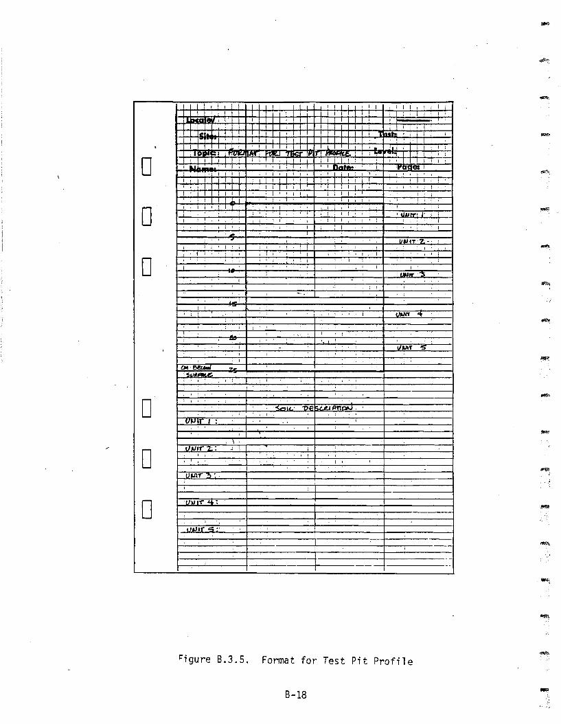
Figure B.3.5. Format for Test Pit Profile
B-18
-
-
I
~II
ii i
I I-MAP SYMBOLS 0- -
- Surface Artifact + -- Depression " -1- Test Pit 0 - 0- Shovel Test 0 -- Grid Test: wi Artifacts • -- Grid Test: Sterile 0 ~D-- spruce Tree -'* ~
-- Birch Tree @ r-
- Dwarf Birch 0 -\
- Marsh * ~
- Stream, Creek -",/ -- Deadfall, Down Tree V -
Trail.... ~-:: ...-- Game ~~ .... '-
,..- ...I-- Deflated Area , \ - 0..... _-"
Boulders, Rocks, outcrop §~- -- Intermediate Contour ........ -- Survey Monument ~ - 0---- -
- - 0,
i II
,I
I i,, i :
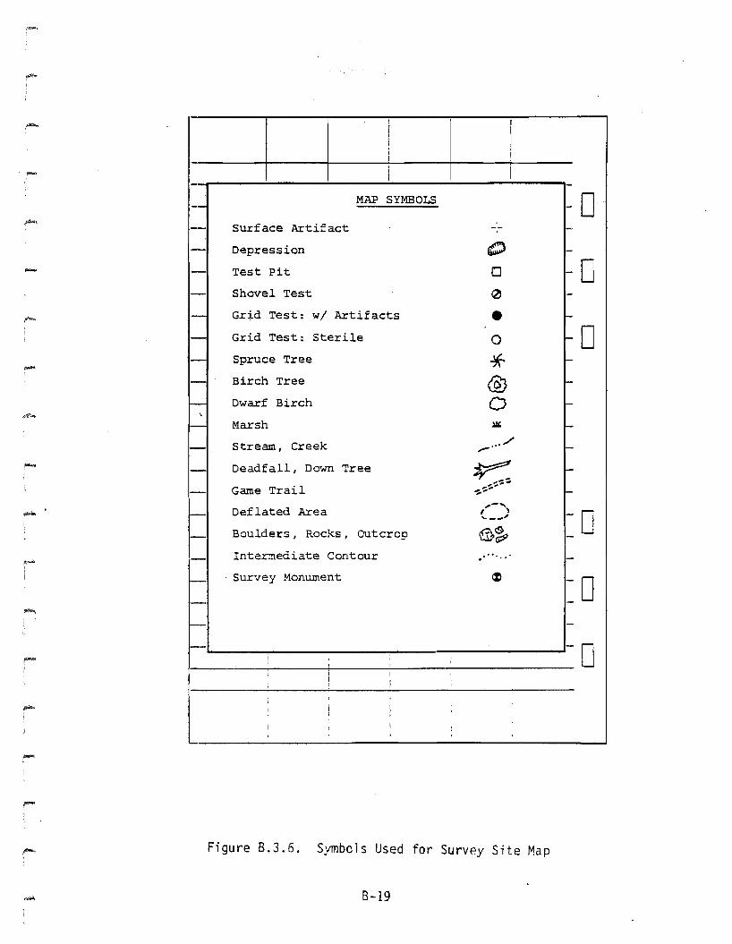
Figure B.3.6. Symbols Used for Survey Site Map
8-19
Ilocale/
Site: Test: I
-
oTopic: II1A17/N4 Alcre-S
Name: Date:
lovell I
o!
o
~TA. -I ! : I I
I ! Iii
o___I I I~;__...;..1__----:-1
1
1 I : Ii
I i
o i I! I
1 II i
I I I I :- __11-
1------~I---i----....:.I----I
I !! Io
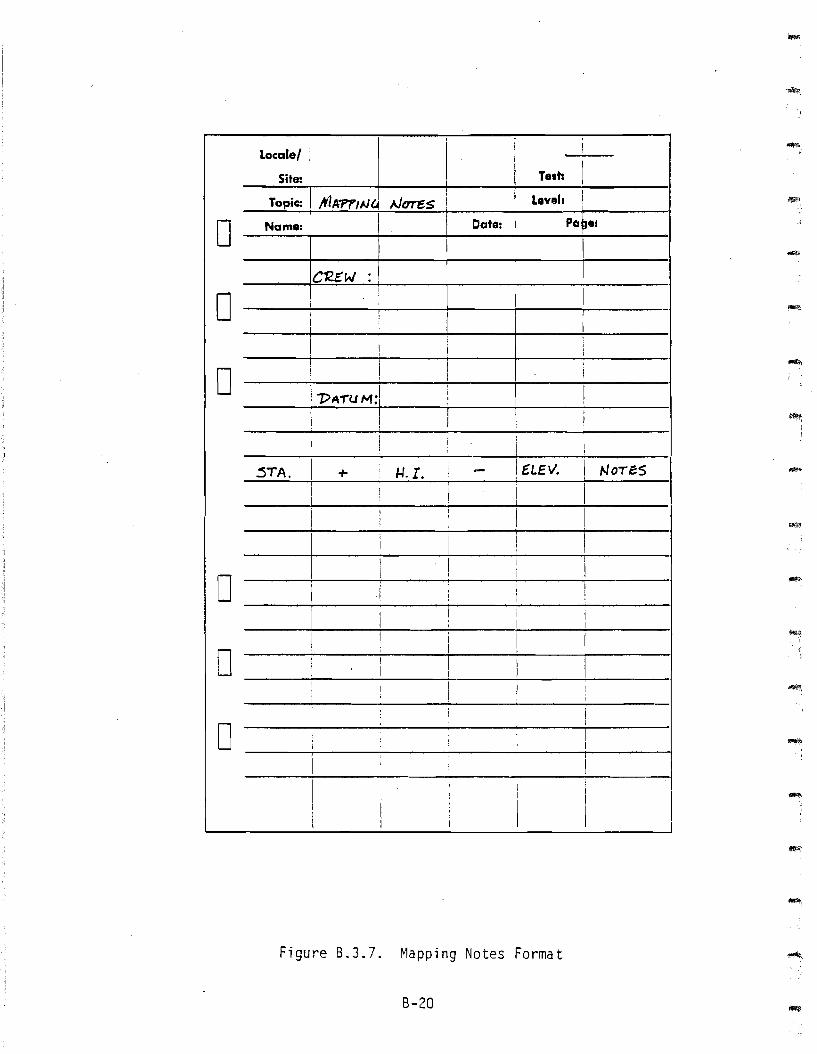
Figure B.3.7. Mapping Notes Format
8-20
oo
I i I
---+-1__-+1__--+[_ Ir----~---I
I tJ-nuE~~ :--~III- 'i .. r~~1--.......I----J
! 41A
! GIl.ID Nkd I I
o-
I :I
-__-:-1__-.:-1_----'1_ i
j -r.O.S. i-=__--1I_1(_OP_--:.O_F-=~;..;.:;1...;.::::_--.;..-1 1
I 0.£.1. I:: : oJJ GR.o,JIfo/'D !
I i I I I
___+-1.=E.:.:.O;.;.:.c=.:.-+I=__--.!.!.=..ei.-..::'1.()i.. CIF! Cl.C$rUee. I: 5TA. i. ~-.-(N~.~---l.SI--_1
; R. r. ~- I H£!~HT ~ IIJSrn,JtH€foJ'T"\ I
____' --=E=L:.::e:..:..:v.:...--:..i=_----+I-=~:..;.,.;:L.e vAnJ,.:....N__.-;..i----Ii i ['I I
---;--1---I---+1-1---+-1 ----II , I
oo
-
-
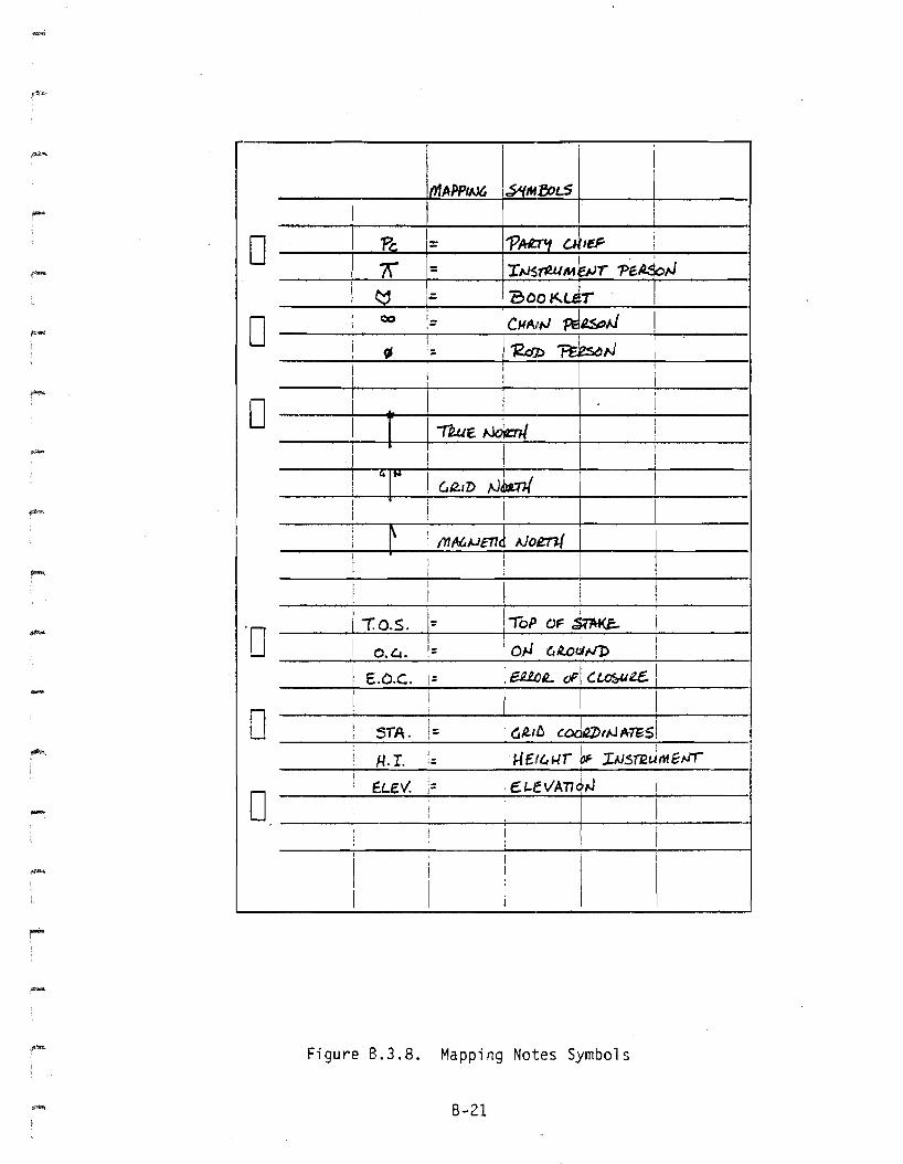
-Figure B.3.8. Mapping Notes Symbols
B-21
l~caial ,I
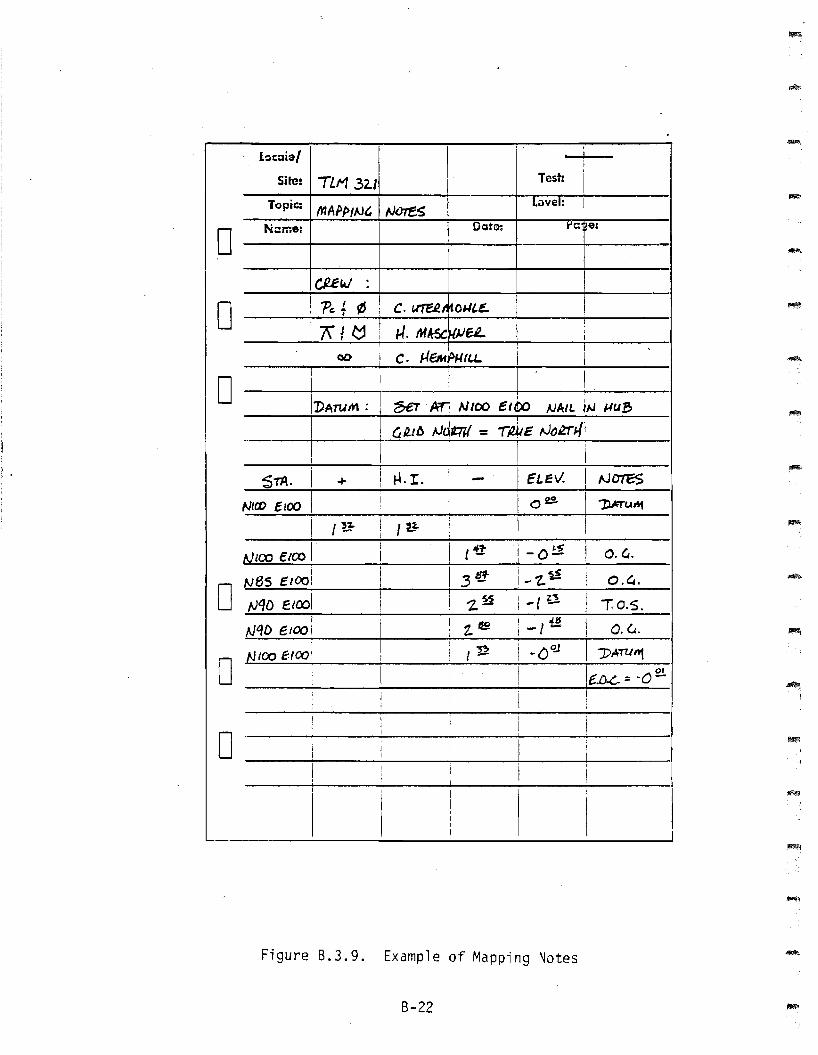
Site: TLM 32.1 Test: iTopic: ffJA/JPIJJt. tJures Lavel:
0N::une: Date: fe e:
c,uW .
0 I 'P,~ ¢ : C. ure.eA~OUl.E. Iii\!~ : H. MA:5c~eL !
i
Ii I-fEM'p~UU. I
I
IDA:M'i C· I
0 ! I I~.Arj N100 etta ~AIL jN ~U8
I I G~/6 .vdtW = -r4E N~.trJ./jII
II
I I Ii !
Sm. I i H.I. i I ELlEY. I NOTES+ I -I
IN!a> clCO I I I i of!!. 1)ATU"1
I
I {E- i I
I{~ !
I
tJ [(::0 EIOO II
I (1ft i -o~ II C.G.I
I I I 3C" i ~I
0N8S clOO: 1- t- O.G.
tJqD ElOOIi I
~ -I U II j 2~ 1: 0.5.I
I I
"HD eICJQ i1
I z'e i-I'£! I 0.6.i II i In ! -oQ.! I
0NiOO e.fOO! I I J)ATtlnt
I I I I I 01, e.D.<-. := ·0-t II i
I 1 !Ii : ;
! ! I I
i0
I I I
i t
[ i II i
!I I j
t
I I!
I
I
I
ItII
i
Figure 8.3.9. Example of Mapping Notes
8-22
-
-
I
I I
I,10' 'v.,.
I I ! I I I I
'.. "_,' ..-, I , I
! I I i If I ) I
j j ,I
I I , 1
I- I ,...,,-'\
I
Tallie I'~
0 I' .. ' I ,
I i , I/''''''' I I I ,
I J II I , I I
,I I I I
i I I I i,- 0 , I I I
; I
, I, I
I II :
I I
I ,
I ,
I I
.-D
oo
I I
I ,
I ,
I '
I ,
. -' .. ,
; ,, I
I I I I
• I
, I
I ,
i I
'! I
' •. G ....
I I, I I
...-o
,--eX
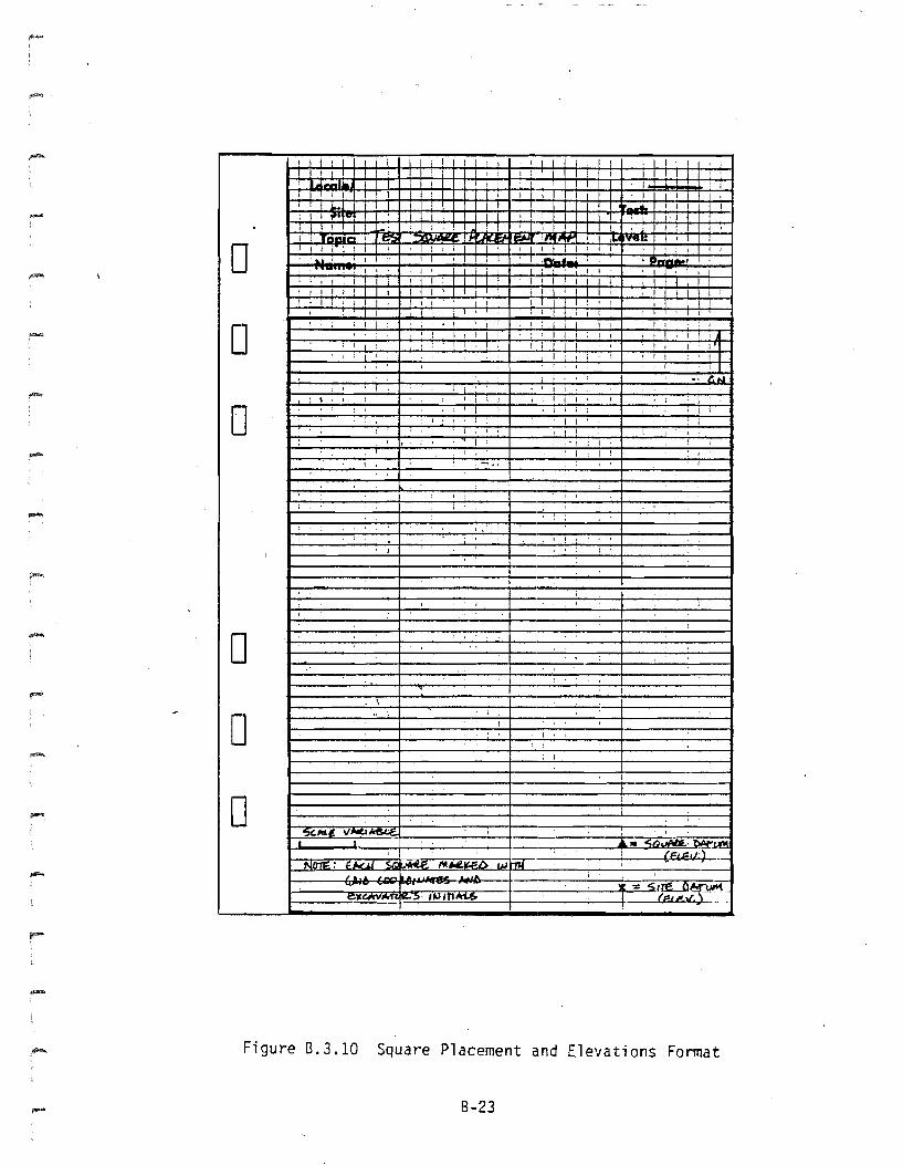
Figure 8.3.10 Square Placement and Elevations Format
B-23
I t ~ : I
I I, I
I ,I I
I :
1'-', ",If., ,.... I tl.o, If\.
0, I , 1 I ,
' ....an_ , , I, I I , ,
I I I
III
I ~ ,
, I
I r j I I I I
I !
I I
, I
-l 1 J Io
, I ,
I 1 I II I J I, ,.. ' .. ,
, I
I I I
I ' , I
I I
I I .• : '.. I'
oI I
I II I I
! I )
I I
I II ! I ! I
I ,
, , -I I : !
! I
, I
I II ,
I ,
...,.
, I
J '
oo
, I, I I
I I ,
--
-.--
=
--
..
/'t.NoI fH:;"'I VI" __. _
r-:::~===t===-----:.- ------+---
o--I-
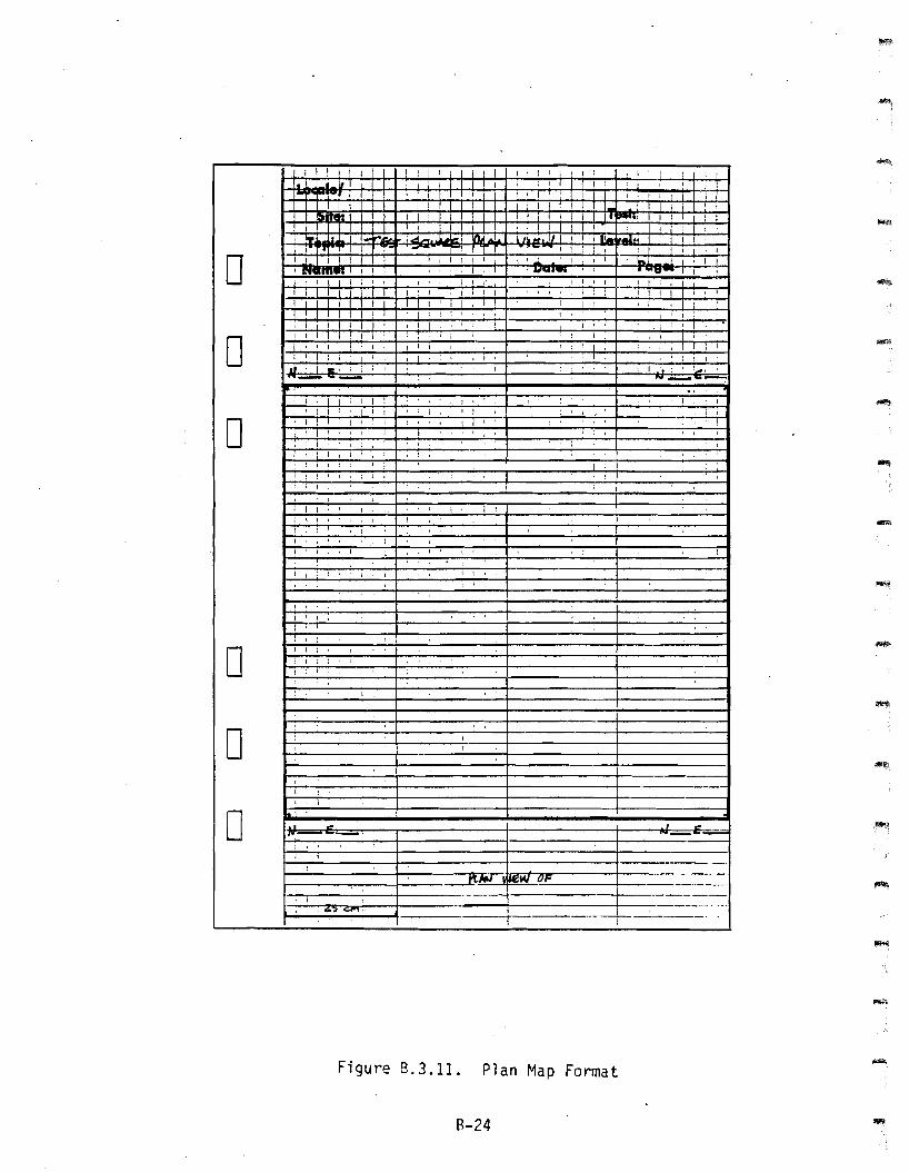
Figure B.3.11. Plan Map Format
B-24
''''''''
--
o! f I I
f--~----+-------- -.-----+-------~
t~__+___t-_-·-, ~-
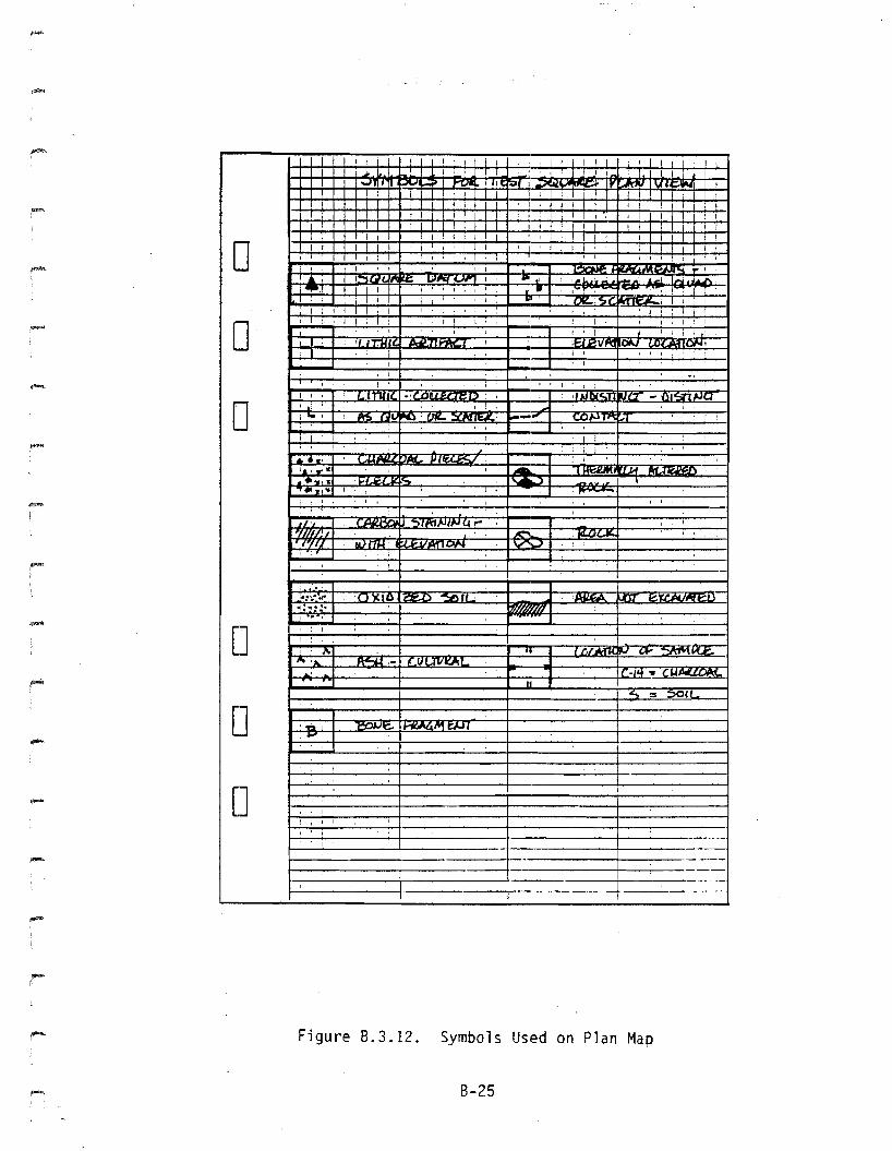
Figure 8.3.12. Symbols Used on Plan Map
8-25
Localel! -t--
Site: Test:
Topic: AP:ntAa ~UPi 7()1J Level:
D~Name: Date: ~aiie :
0 1J~f/1.WIENa. ~ MA'1UJA1., ~iupnOA1
I iI
i!
0I I
I I,I
I!
I I
iI i
I
i Ii
III
0I
I ,I i
I Iii
II
D: I
!I
I III
I !\
D:
i i I! I I
I
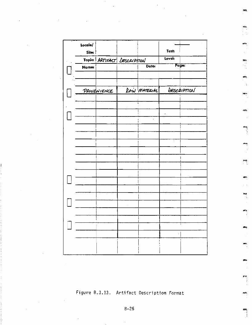
Figure 8.3.13. Artifact Description Format
8-26
-
-

-
IAe:nFAC.~ ~4iP'rltJ1J EAAfMAr1cN I
o--I------l----+-------+-_f----l
PaoveiJletJt€. (fAl 1:ItI)
oD
! !~iop A£'T1~ II ~ =I~ t ~-·AT-lT5--';-'BAs-e..--1
--_I I I \--+1--1RAW AtMUIAL I j--;J)t. nPa
! I I
WCXJD i i ~.Mf4 Po,krrsiii LeM ~I.(~ hl,N1"SI ! I LkN&oLAre A,f,.tJT"S
oo
......
Figure B.3.14. Artifact Description Guidelines
B-27
I!
-ro< -rlfPe.i L
-rRJAN ~uLAt2.. Po tJrS
tK~ .- ~J1."'" Co~e. 0,"IGAD&1tU '7?1Bte:r
Ii:&AOe. C(;i2.E..
: ~ Jv'E-vA170A11 ;:u..~E- DI
II
I ~ ~E-I ;
UM1M~AJeS
! MMoE2-$ !
0I
: I
P£PJ&.Es..N~
I I
I I 1
I, II I
I~NA-L ~~£I4L. i !
-I i
WJ8U/uJEl>MA1tfMM,... COMta-te I~M~
I
I I I I'f,f/U) t;N..t,lAJ~l>
I ri
T:if;4 ! I 11.EAV1U-f &1W~1:JI
UIJ16EJJTI ;;(~Bl€. I 1 ! )
I
0II !
Ii
I i I
II ;, I
,I
, Ii
:
0I
;: I It i
I
I
I i :t
0I i , ,\ I
, I
: j i:
! I I
, ,i I, I,
I, I
Figure 8.3.15. Artifact Description Guidelines (Continued)
8-28
--~I
-
Locale/ I II
Site: I Test:/
Topic C-f4 ~~J}le - Level:
0 Name: Date: Pa~ ~:
I~'edJ -JI. !~le ~... ;'''''0''"
0 C·$.! II1 I
I II
iII I
0 i II
, i, I
II
:I I ~ Ii I I
II
! I I I
! :I
I i II ,i ! I
0I i i
1 i I II
I i
II I I
II i I
I I I I
0!I
) IIi I --J
I
!i
1 I III I
0 I
i II,
I I I I
I II I
I III:
IiIiI
Figure 8.3.16. C-14 Sample Recording Format
8-29
~W~N 0A) f.i2tJVF.uI8XC.· '" e D (At~ Pu.~ 01J p.UdJ ~j))
'aJ , ..... 1\.i
0 -I'.:
iI!
I
~IAJ70d WrTJl/~ ~U~ (II" ~e.e.,I 1 I i I
NJ~ 'BoAllE U(.,t.:>7§?. ere. )1 i
c)
-
-
I I I
I !
!-I
I----..:.::.{.:;.:.~._I_l .....:tl:..:..:.A....:....~::::=iI......:L::.:./.:....'"....:....'n.:...:.:.-IJ':;.:..;..::fJ:.:..ATE.:.=...=..-:..A:tl..-=' ....:....~~.:..:J.f,=PA....:.......:: /Jar:Js:::.;:'::..:::.::.:..''''-"",,_ D'Ptrres UP/fE£ ~to~€JJI, e'{Z..
1-----....:....-1 __---;i -:.! ....:.i -- Di j
: I
, I! D1__-----I.!'Bu~~~uJ~,....:.:::.ert-~._-,-I__..:...1 _
1-----;---1 ! ! I
FJ hCH€Du.xJ.t.AL A1JtJ!(Ji ~~ttAL S<'iJ/;:flA1J4!
Figure B.3.17. C-14 Sample Recording Guidelines
B-30
I
Locale/I I
iSite: Test: I
Topic: ~u.. 1)E S(fUPnOAlLevel:
0 Name: Datel Pag'l
UNIT tl: Mu»seu. (,iA. rr f)F3!:1:./J. ~fJTlotJ
0 I II I
II I II II I I
D I i !i -I I! i
! !
I iI I
II
. II I
I I II
I II:
i I1
i
0!
I,! :
I I II
I I \
DI I
I I
) ! III
I i II I I
D i
~ III !
I Ii I I
I I \I
Figure 8.3.18. Soil/Sediment Description Format
8-31
,
I , , ,I , A ,II. .... .. 1,..~... '
_.-.I_i ,"' ..... 1. """':J...
I~' I....,.. ... "" -- ....... l-r........"-~ , '~--" II I I 1 I I I
I I I ! , I ! , I : I
! I I I I I I, ! , , I I I ! I--- I : I
, , I I I I , I I I , , ,.... , I ..... ,;;, 1 I I I 1 , I :
! I , , I I I , , , I : , ,! 0. , ,I , , I
, , I : : , , , I I I , 1 ,I~ I I I I , , I , , I
,I~I w: ~D .!,-- ,Vt::lf/ IIAJIf ';" I I I
,-;o:::p I I , ,I : II I : ,
I, : I ....
'-.=::::st I I I I I ; I I I ; i'
IIII ,
I I, I , I I
I I I , , I ; n 0, 'r,/NeLU I , I
I I I I : , . I I : I ,I 1 ,
I, I I I I ,
, I . , I I , , I 1
""'" , , I I I I I : I I ! ,I , I ! I I ,
! ........ "Y. ,.1 I , I I -,
0A' I , I I : I I I I
I I ! I I I , , I .....I.""... : i , i
, I I I I: IX" 'l.I
! fl' I !
f",- .~ "'- I ,n . { LDlfJIf:.~.
I I... , • I
1 :,,_.,1"..1-
..~ .. '"" .....-.....::'" '::;' 1'1' ~1'fN J ~AN, -1"""'-'- ..... ( ~" "
0~....., ...
-.. 1 :I. I
, ,. .::;1' '~. -'V _V
Iv" " !
.. ! M
0.. .,........ I ,..,0",0 ,
I N''In V
IN 'I( ~':7r r;.... t"J".~, .....,11't{. e.c:J lUU'1!7'>lJ.. . j... I ....
0. I ,1.1",-" ;1'" i,- i
,-, A, II , ,I
¥=( jI II r- I
-
-
-
Figure 8.3.19. Symbols Used for Wall Profiles
8-32
-
..-"
-
.-.
I
1II
~'L. '1 est:.D.( /!-no/J CoJ(I)EL wes j
0 VARIA fHUS
SDu. 1'~p J)~"WeT
L/Gf.JTIlJiI : OVUl/'lS. I- $UJJ~'1 up/)U- -n~
0I Ii
! II
(}1t(IJ~ ! I
f{ut, \ i II
0 I vALUe JC/{/k)MAI -I I
! I
C()UJ(L IDe~fjT7MJ iI
iI !
"De!.t ~(P7lC:A1 I !~ I!
I pftfLncLe I~ ee : I -t I CLAit I
\I
! I~I~ .003., ,. ...
I i i PnJe~ I . 125' t"'"
II
I~$wb II .25 1\< ...;
II ii ~NUtl.I ·s I\< ...
0I I
I I i ~~"8(..el I2 "" ...;
I
II I (,5,.. ...I i f9&3t-.f;:. i
I
I ~UU)eJ II 250 ......
0I
i I
I III I
I L_I II ~(,. MolS(Z.( i!.£t, i I Ii TEn-wiE- !
0 I
I !i 'DE~ o.c ~l2..nAJG
!1 ,
IiI
I
[ II
;I
I t
t I t
Figure B.3.20. Soil/Sediment Description Guidelines
B-33
;
:
oD
1 I I i I
iE-'f""ffCHf *!.F U,lJ rrS I : CO",,...jI\JU'Ous / f~/SLOAJ71';"."~1----+-1-------+I-_+_~-'--,-i- DF~r ~-u~s:1 P~ESEJr I Ae;SICJJT !
1_......:e.:..::..U-=-"TlAJZ.'--".---,-At:>c...:_M:....:........:~'-'-=.J-".:...oAt...=-:_-'-PD-:-"f=5f....,;J(.'-=t-'--I-,1 :flr:fA""""",,=€.ve=~::-.",-1___ 0·1 IN fTtT~ ( ,~Stt/e..
.....
,------'--_1_:-'-'- 0
1_--;.....-1 -....:.:_-----:-_ D
-
Figure 8.3.21. Soil/Sediment Description Guidelines (Continued)
8-34
Locale!
Site: Teth I
oTocic: 'P#lrrO L PCIt~ame: I
Lavels I
IOates Pa~es
I I
I ; i I---"'-!----..;..:-----'-;-=j---+-----l---.;-..-.--I---.;-!-----':---.;-\----I
'1Jf/lECTlolJ
___-4-1__~! +I I .;...i I
II ·1 ! I i
-----i----:---I~:I=====:1=======:__1-,--,_--.:....1_----:.1__1__-;-\ I
I i I i
D
D
I I' !I i
I ! IoD
! ' i I I
__"'-I__: ---l-I-----J~---.Ii___--t! I I
- Figure 8.3.22. Photo Log Format
8-35
,Localel I
Site: Test: I~Jl.LI~ Ft/L c;r-". 'N£J*
Level:Topic: I
0 Namo: Date: Par e:I
~ ~e;,.rl?£r - I £k.~e.aEJJteI i
0 <In'I!~ f)At~I i -!
!I
I II
0 I it
I,!
<"Jl,J~ L-o/~ t:a:>Af I- - .sfiJ;~ UJutt-e1- Mff I
I' I II I
I ! IAU/(.5 ! ,l./UM~~(s"J :
I! I
IIJI
I I IIi
0 I I i;
, I
I I!
I,
: i I Ii
I I
D I
)! I !I , I ' !i t". frCDI:;/"} 'P1I I,I I
} JlfO-f-.b B~I
0 i I iI ,
\I" I
I!
i
III
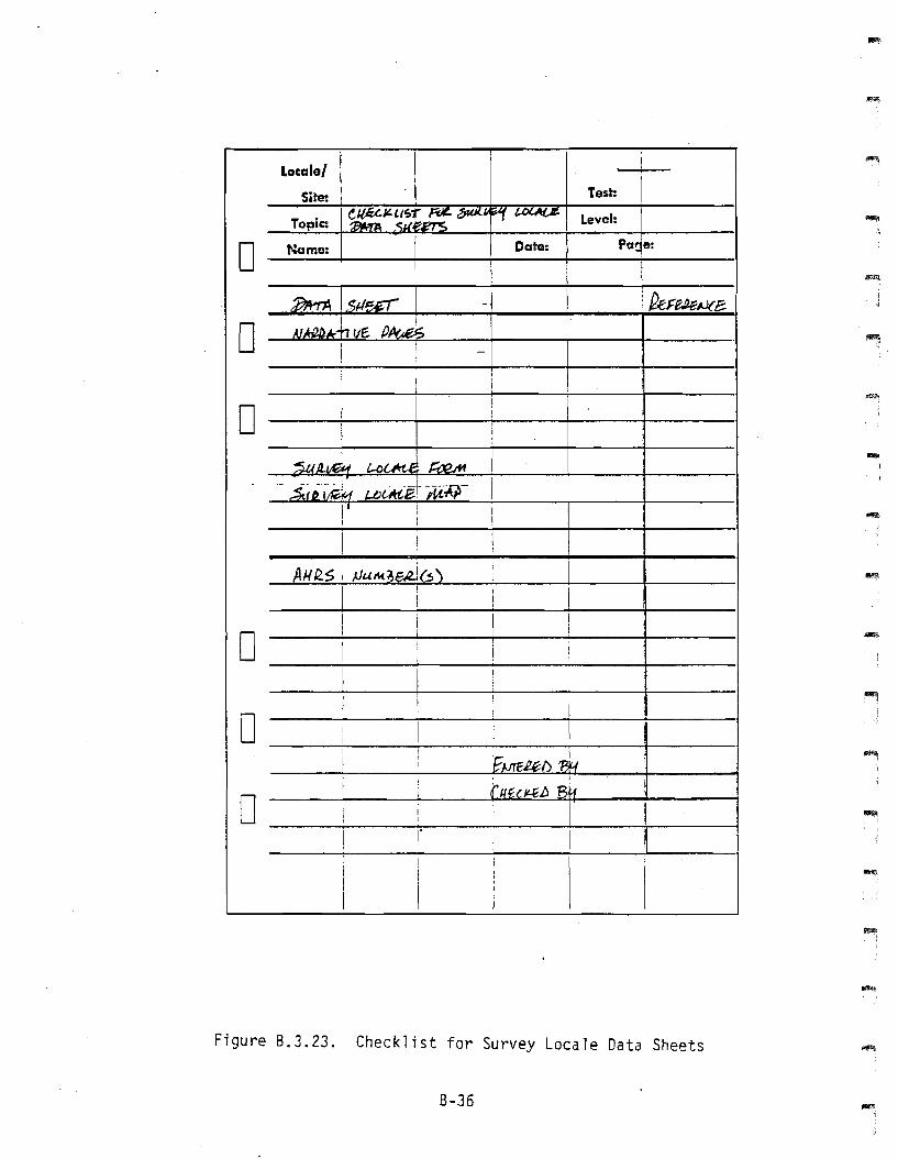
Figure 8.3.23. Checklist for Survey Locale Data Sheets
8-36
-.
--,.....
~,
.~.,
I~
,~
-
Locale' I
ISite: Test:
Topic: !C/(fLUI;~,;"'" '5f1i; L:o'F'" ~,rc;.1 ~ Level:IJAVE.Y
0 Namel
I
~.M'Pc ~.:
~ fUT .~~2ClJa;
0I I
~~ vf- jJAu&i:,t;
II
Ii..
I-
III
0 I I II
I,
~,~ cbj2fif
SirE f1.t!A-P I -
&Fltl i I II ! ,- I1)A.A:Pr IHArUAT1I/E.I I
I
II
I ;
I 1 j II I
$4.~ n~ :1 UTMj I
0t\( ~ffil. MAP!
I 1 orn,-~ AtA-PS I
1j. I Ir
I I I I0
I II
I III I ! II
II
I ! ~.urF,2..W 13'1
0i
I I r/tPnQb B'1I
! I I j, I
IIIII
I
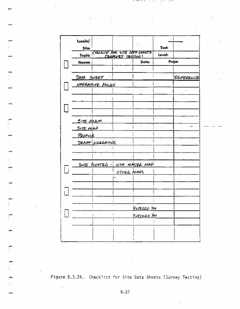
Figure 8.3.24. Checklist for Site Data Sheets (Survey Testing)
B-37
-Locale'
Site: Test:IUt~/.1";>( /'Of/:- ... , .... '''''j' ~~~ I' Laval:Topic 11'''-
IDate: Pa ~.:D Name.
7)~ >#.eet' ~I!£J.}C£
0 "f1/~ t:lA eur ; f.Uv'M1oN ~ -rt3srS6"u~
FIELtJ ~1A.,..auc. ((J(AM 1Jl.~'
0]:tUD !Julff2tUS (r~ I~/{")
c:rnr£12.
III
D
0.~ t3tf
D (j{.fZk:.E..b ' ~'1I
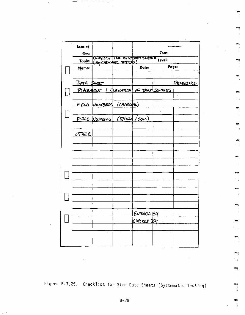
Figure B.3.25. Checklist for Site Data Sheets (Systematic Testing)
8-38
-
--
-
1!!'i!;I.i
,-
-
Locale/ II
Site: Test: IToplcz '"~ (~T_
1~11::r Lavel:15#iW'S (. Art!
0 .Hamlt Da", 'tiD.If
'ST,!1.Ar. -puw NNlRAf71tf!. "....... '''' ~-I"t OT"He/J...(,I.N ,.,. MAP 7>f:S£RJ~171()N 1)A7Jl
0
0 II
iI I ,
0 I
I I
I
0 EI I I I
I F~a ~41
0 I c ~
I
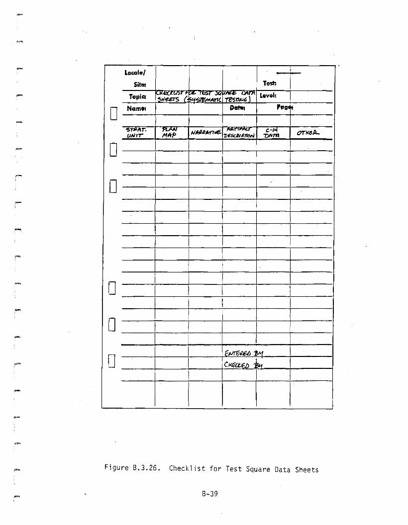
Figure 8.3.26. Checklist for Test Square Data Sheets
8-39
Locale/
Site: Test:
-.
:
II
= Ii
o_N:.:::;am:.:..:.::e::.....j.. + +-_D_ate:_.+ P_C-j-1e: -11
oo
-
o
oo -
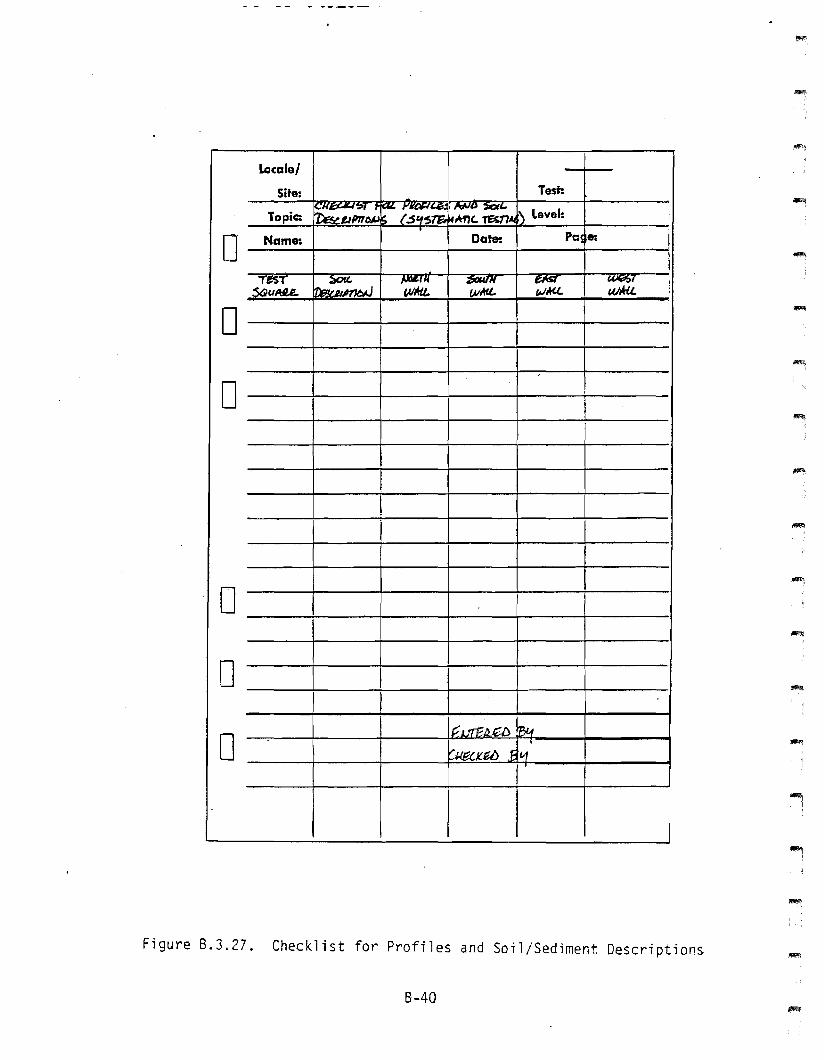
Figure 8.3.27. Checklist for Profiles and Soil/Sediment Descriptions
8-40
....I
-
8.4 - SITE DATA COOING FORM
8-41
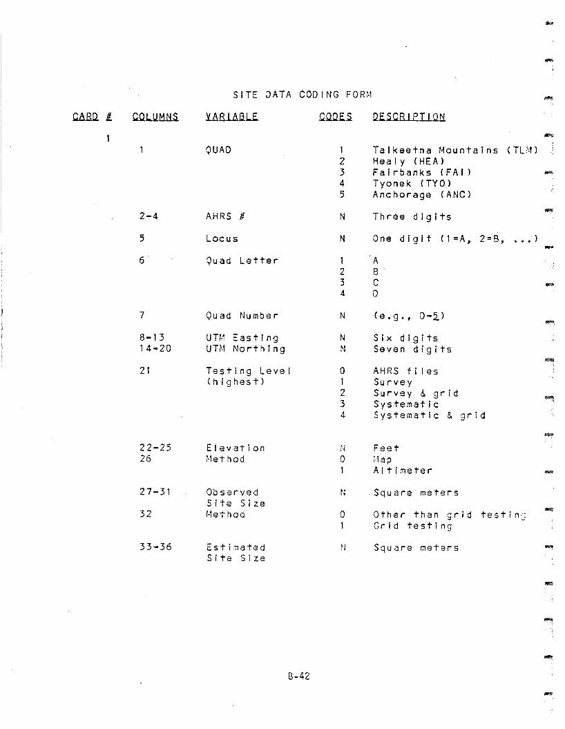
-SITE DATA COD I NG FOR~l -
caRo. It. CQ1.lJ1:11iS. URJ...aliU CQ.Qf.S o.f.SCRl.E.Il..Q1f
QUAD 1 Talkeetna r...fou nt a Ins (TU·' )2 Healy (HEA)3 Fairbanks (FA I )4 Tyonek (TY 0)5 Anchorage (ANC)
2-4 A.HRS # N Three digits
5 Locus N One digit ( 1=A, 2 =8, 'I' • • )
~,
6 Quad Letter 1 A2 83 C -4 D
7 Quad Number N (e.g., 0-2.)
8-13 UTM Easting N Six digits14-20 UTM Northing N Seven digits
21 Testing Level 0 AHRS f i I es(highest) 1 Survey
2 Survey & grid3 Systematic4 Systematic & grid
22-25 Elevation N Feet26 ~·let hod a ;.Iap
1 Altimeter
27-31 Observed N Square metersSite Size
32 i·let hod a Other than grid testin']1 Grid testing
33-36 Estimated ~J Square metersSite Size
B-42
-
-
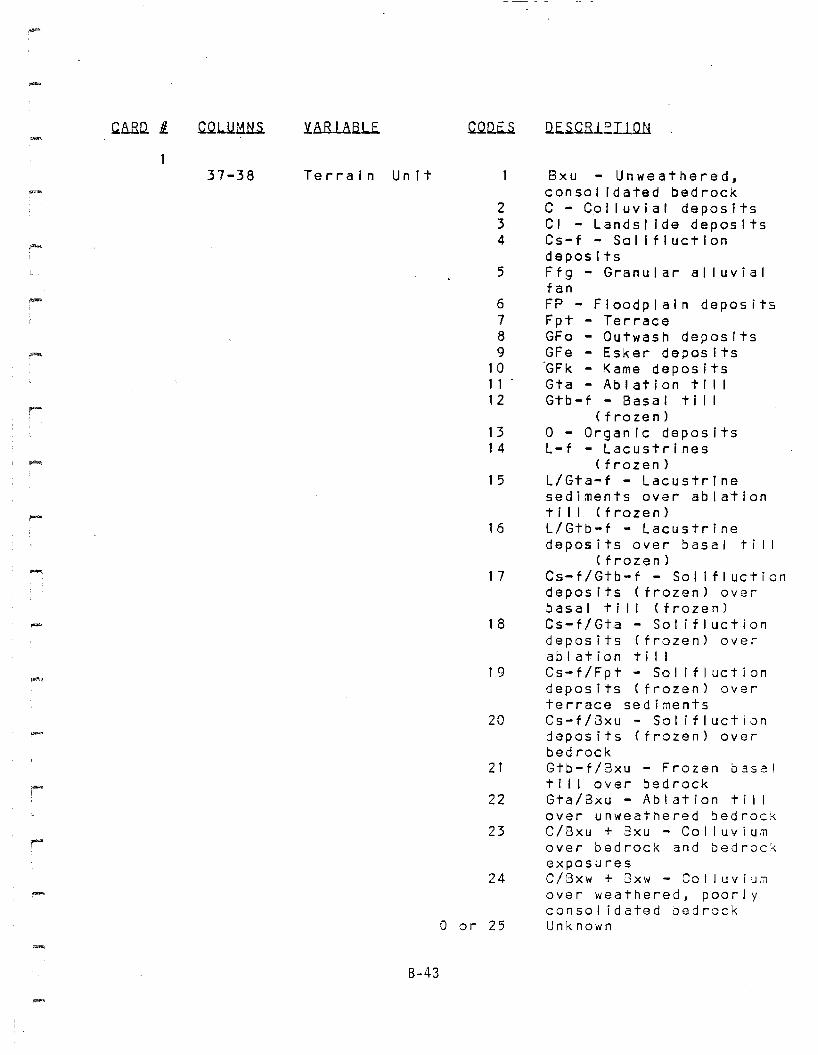
CARD. Ii.
37-38
YARl&SJ•.f. .
Terrain Unit
B-43
234
5
6789
101 1 .12
131 4
15
16
17
18
19
20
21
22
23
24
o or 25
Q.E.~B.l.e.liQtl
Bxu - Unweathered,consolIdated bedrockC - CQI luvial depositsCI - landsl Ide depositsCs-f - Sol ifluctlondepositsFfg - Granular alluvialfanFP - Floodplain depositsFpt - TerraceGFo - Outwash depositsGFe - Esker deposits~Fk - Kame depositsGta Ab I at jon t I I IGtb-f - Basal till
(frozen)o - OrganIc depositsl-f - lacustrines
(frozen)l/Gta-f - lacustrinesediments over ablationtill (frozen)L/Gtb-f - lacustrinedeposits over basal ti II
(frozen)Cs-f/Gtb-f - Solifluctiondeposits (frozen) overbasal till (frozen)Cs-f/Gta - So! ifluctiondeposits (frozen) overablation tillCs-f/Fpt - Solifluctiondeposits (frozen) overterrace sedimentsCs-f/8xu - Solifluctiondeposits (frozen) overbedrockGtb-f/3xu - Frozen basalti I lover bedrockGta/8xu - Ablation tillover unweathered bedroCKC/8xu + Bxu - Co I I UIJ i U,l1
over bedrock and bedrockexposuresC/8xw + Gxw - Col luviu~over weathered, poorlycanso j i dated bed rockUnkno\~n
CARU fi. y..8.RUaL.E. G..QU.E..s. Q..E..s.C.Rl.E.Il.Qtl
~i
39-40
41-42
Vegetation(After UAExperimentalStation)
Landform
1 R - Rock2 ~~CT - Mat and cushion -tundra3 SGT - Sedge grass tundra4 \'ISG - Wet sedge grass -5 ass - Open black spruce6 \'ISS - ~/ood I and black sp r uce'7 OS\" - Open white spruce8 wsw \'Iood I and white ~;- spruc9 CBF - Closed birch forest
10 OSF - Open birch forest11 CP - Closed balsam poplar ~12 'OP - Open balsam poplar13 CM - Closed mixed forest14 OM - Open mixed forest15 CTS - Closed ta I I shrub16 OTS - Open ta I I shrub17 B - Birch shrub18 \-, - \'1 i I low shrub19 LS - Low shrub20 G - Grassland
0 or 21 Unknown
1 Plain - flat2 Plain - sloping -3 rIo un t a In, hill , etc.4 Crag and ta i I5 Kame6 Esker7 Kettle8 :lor a I ne9 Terrace - river -10 Terrace - kame
11 Ridge12 Saddle13 Valley14 Lake shore15 Stream margin16 Stream confluence1 7 Lake outlet/inlet18 Floodplain -
8-44
Y.aRlaaJ..£. ~Q.Q..E..s. Q..E.~B.le.I1Q.tl
434445
4647
48-50
e..t:Qx.lmil~
Terrain featureswithin 1 km
LakesStreamsRivers and majorTributarIes\vet I and s1,1 i nera I I I c k s
1::H1I ll.s.E.D.
o Absent1 Present
NN
NNN
- 51-52 Land Status o123
4
5
6
789
101 1121 3
U - UnknownPR - PrivateVSI- Vii/age SectionVS-Ch - Village SelectionChickaloonVS-Kn - Village SelectionKnikVS-Ty - Village SelectionTyoneBA - Borough Approved orPatentedSP - State PatentedSS - State SelectedSSS - State SelectedSuspendedF - GL ~ ,1 - SL :,1F-USAF - U.S. AirforeeF-USAR - U.S. Ar~y
AK - Alaska Railroad
.-
53-54
5556-5859-60
SurveyShove I TestsTest pitsGrid shovel TestsTest Squares
8-45
N
caRD. Ii. CQLUMN5. YARll.6lE. C.OOE..s. llE..s.C.RIEIIQtl
....,
Accession Number ( 3 digits)
<Access ion Number ( 3 digits
Acces::;ion Number (3 digits
Accession Number ( 3 digitsl
Accession Number ( 3 digits -IIlO\!\
6162-646566-686970-727374-767778-80
01234
1980 Testing LevelUA80- N1981 Testing LevelUA81- N1982 Testing LevelUA82- N1983 Testing LevelUA83- N1984 Testing LevelUA84- N
B-46
I~tlla..g, l~~lNot testedSurvey onlySurvey &/ Grid
Sustematlc (+/- survey)Systematic & Grid(+ or - survey)
-.
-
CaBo. I c.o..L.U.t:U:!S y.aRla.6.lE. C'clUE.S D.E..5..CRlE.I1Qli
2Card number 2
~~~
llr.lll~.a.A.h.L~..u.o.~ e.~~a.lli
0 Absent1 Present
.....
-....
2345678910111213141516171 81920
Unknown SurfaceSurfaceOrganics (current)Organic silt (current)Eo I Ian or otherOrganIcs (burled)OrganIc silt (buried)Devi I tephraEo I i an sand or otherWatana tephra (oxidized or unknown)Watana tephra (unoxldized)Paleosol. eolian. or otherOshetna tephraEolian sandPaleosol or otherEol ian sandDriftBedrockUnknown subsurface
STRATIGRAPHIC POSITION
Note: use same code inboth positions if not acontact.
......
21-2223-24
25-2627-28
llAAar. l..lm1.IUnit code/unit code
LQ.1i~r. l..lmlIUnit code/unit code
123456789
1a1 11213141516171319
Unknown SurfaceSurfaceOrganics (current)Organic silt (current)Eo I i an sand or otherOrganics (buried)Organic silt (buried)Devil tephraEol ian sand or otherWatana tephra (oxidized)Watana tephra (unoxidized)Paleosol. eolian. or otherOshetna tephraEol ian sandPaleosol or otherEol ian sandDriftBedrockUnknown subsurface
B-47
~8.B..ll 11.2
GOLUMt;lS. yftRlAfiJ...E. CQUE..5. QE.S.~B...LE.Il.QN """
29-3233-35
Upper Limiting Date
B.P.S.D.
Unit Date
36-39 B.P.40-42 S.D.
Lower Limiting Date
43-4647-49
50-5152-53
54-5556-57
58-5960-61
62-6565-69
70-7172-73
74-7576-77
78-79
B.P.S.D.
Skull - burned/calcined" unburned
Axial - burned/calcIned" unburned
Other identIfied elements - burned/calcIned" " " unburned
Unidentified elements - burned/calcined" "- unburned
Total number of bones burned/calcined" II " " unburned
Total number of bones burned/calcined" " " n unburned
Tota I number of bones
-
-
80 El~~t ~~~~ ~~ iQ~ ~lt~ a1
8-48
NoYes
3
~LUMNS. y.JiRl&a.l..E.
Card Number 3
UE..s.C.RIEI1.Q!i
2-34-56-78-9
10-1 112-1314-1516-17
18-1920-2122-2324-25
26-2728-2930-3132-33
34-3536-3738-3940 -41
Skull & antlerPositive - burned/calcined
" - unburnedTentative - burned/calcined
n - unburned
Axial (ribs & vertebrae)Positive - burned/calcined
11 - unburnedTentative - burned/calcined
" - unburned
Shoulder & pelvic girdlesPositive - burned/calcined
" - unburnedTentative - burned/calcined
" - unburned
LimbsPositive - burned/calcined
" -unburnedTentative - burned/calcined
" - unburne(j
ExtremitiesPositive - burned/calcined
" - unburnedTentative - burned/calcined
" - unburned
B-49
c.aM Ii.
3
COLUMNS UE.5.C.R1EI1.Q.H
42434445
46474849
50515253
54555657
58596061
6263-64
65
Skull & antlerPositive - burned/calcined
tr _ unburnedTentative - burned/calcined
If - unburned
Axial (ribs & vertebrae)Positive - burned/calcined
" - unburnedTentative - burned/calcl~ed
tr - unburned
Shoulder & pelvic girdlesPositive - burned/calcined
" - unburnedTentative - burned/calcined
" - unburned
LimbsPositive - burned/calcined
If - unburnedTentative - burned/calcined
If - unburned
ExtremitiesPositive - burned/calcined
" - unburnedTentative - burned/calcined
If - unburned
OlliE-E lQ.E.llI1El&a~E. M&MtlaL5.
Number of speciesNumber of bones
E.LQ.8.&o None1 Seeds2 r~ a c r 0 f 0 s s i I s3 Seeds & macrofossils4 Charred seeds5 Charred macrofoss i 'S
(charcoal)6 Charred seeds &
macrofossi Is
B-50
'"""
-
8-51
4
Y.&BI ABI..E.
Card Number
QQUE..5.
4
llf..5.QEIEIIQl:L
2-67 -1 11 2-1516-1920-2324-2728-3132-34353637
38-3940-4142-4344-4546-4748-4950-5152-53545556
57-5859-6061-6263-6465-6667-6869-70'71 -72737475
QQ~~t~~ llth~ &Ltl~~t~ ~~ Ra~ M~t~~l~l(Greater than t/8")
ArgilliteBasaltChalcedonyChertObsidianQuartzQuartziteRh yo liteIgneous~~etamorphic
Sedimentary
MQ.d.lil~.l1 El~li~~
ArgilliteBasaltChalcedonyChertObsidianQuartzQuartziteRh yo J i teIgneousHetamorphicSedimentary
Argi II iteBasaltChalcedonyChertObsidianQU3rtzQuartziteRhyo! iteIgneous:let3:T1orp hi cSedinentary
B-52
-
~Q. fl. ~l...UMH£ .Y.bB.l.8..6Lf. COo.E..5. Q.E..5.CRIE.Il.Qt:i~.
5
Card Number 5
a~~
2-3 Arg I I lite4-5 Basalt6-7 Chalcedony8-9 Chert10-11 Obsidian12-13 Quartz14-15 Quartzite16-17 Rhyolite18 Igneous19 ~·fetamorph Ic20 Sedimentary
Ml..\;.LQ.b.l.aJ1.e.s.
21-22 Arg I I lite23 Basalt24-25 Chalcedony26-28 Chert29-30 Obsidian31 Qu artz32 Quartzite33 Rhyolite34 Igneous
"..., 35 ~, etam0 r phi c36 Sedimentary
B..l,u:.l.ns.
37 Arg I I I I te38 Basalt39 Cha lcedony .40 Chert41 Obsidian42 Quartz43 Quartzite44 Rhyol ite,- 45 Igneous46 1'1etamorphlc47 Sedimentary
8-53
"""!
c.aRll L c.m..u.t:1H.S. yaRlaau. C.UllE.S Q.E..5.C.RIJ:.IIUli
5
au.r:.ln Su.allJi
48 Arg i I I I te49 Basalt50 Chalcedony51 Chert'52 Obsidian53 Quartz54 Quartzite55 Rhyo I Ite56 Igneous57 Metamorphic58 Sed j'mentary
~
al.i~~
59-60 Arg i I I Ite61-62 Basalt63-64 Chalcedony65-66 Chert67-68 Obsidian69-70 Quartz71-72 Quartzite73-74 Rhyol ite
"""175 Igneous I
I
76 r-oletamorph i c I
77 Sedimentary
8-54
-~
c.aRQ. i ~llMNS. URl.8.B..LE. CQJl.E..s. Q.E..s.CRlfIlQ.tl
6·
- Card Number 6
e..c..aiQr:..m~
""'" 2 Arg I' I I I te3 Ba$alt4 Chalcedony5 Chert6 Obsidian7 Quartz8 Quartzite9 Rhyolite10 Igneous11 Metamorphic12 Sedimentary
tl.QJ:~.b..e..d. fQln.1~"""
13-14 Arg I I I I te15-16 Basalt17-1 8 Chalcedony19-20 Chert21-22 Obsidian23-24 Quartz25-26 Quartzite27-28 Rhyolite29 Igneous30 r·l etam0 r phi c31 Sedimentary
""'" .s..1.e.mm.e.~ E.Q.ln.1~
32 Argl J lite33 Basalt34 Chalcedony35 Chert36 Obsidian37 Quartz38 Quartzite39 Rhyol ite40 Igneous41 Metamorphic42 Sedir.lentary
-IB-55
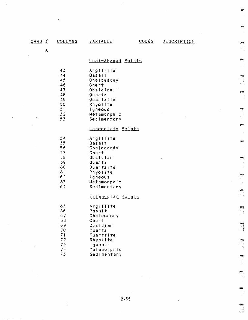
~&.RQ. Il ~!J1lli.S. YAR1&.6.L.E. ~.Q.Q..E..s. Q..E..s.~lEI1.Q..t:! '~
6
J....a.ll=.5..h.a..Il~.i E.QJ.1l1.:i
43 Argillite44 Basalt45 Chalcedony46 Chert47 Obsidian48 Quartz49 Quartzite50 Rhyolite51 Igneous52 Metamorphic53 Sedimentary
~
.L.a.ll~SlQ.l.a.1~ E.Ql1l1.:i
54 Argi II ite55 Basalt56 Chalcedony57 Chert58 Obsidian ~
59 Quartz60 Quartzite61 Rh yo lite62 Igneous63 t·1e t a mo r phi c64 Sedimentary
IL:.l.a.ll~JJ..1..a.L:. E.Ql1l1.:i
65 Argi Ilite66 Basalt67 Chalcedony68 Chert69 Obsld,ian70 Quartz71 Quartzite72 Rhyol ite ~
73 Igneous74 1·1 eta m0 r phi c75 Sedimentary
B-56
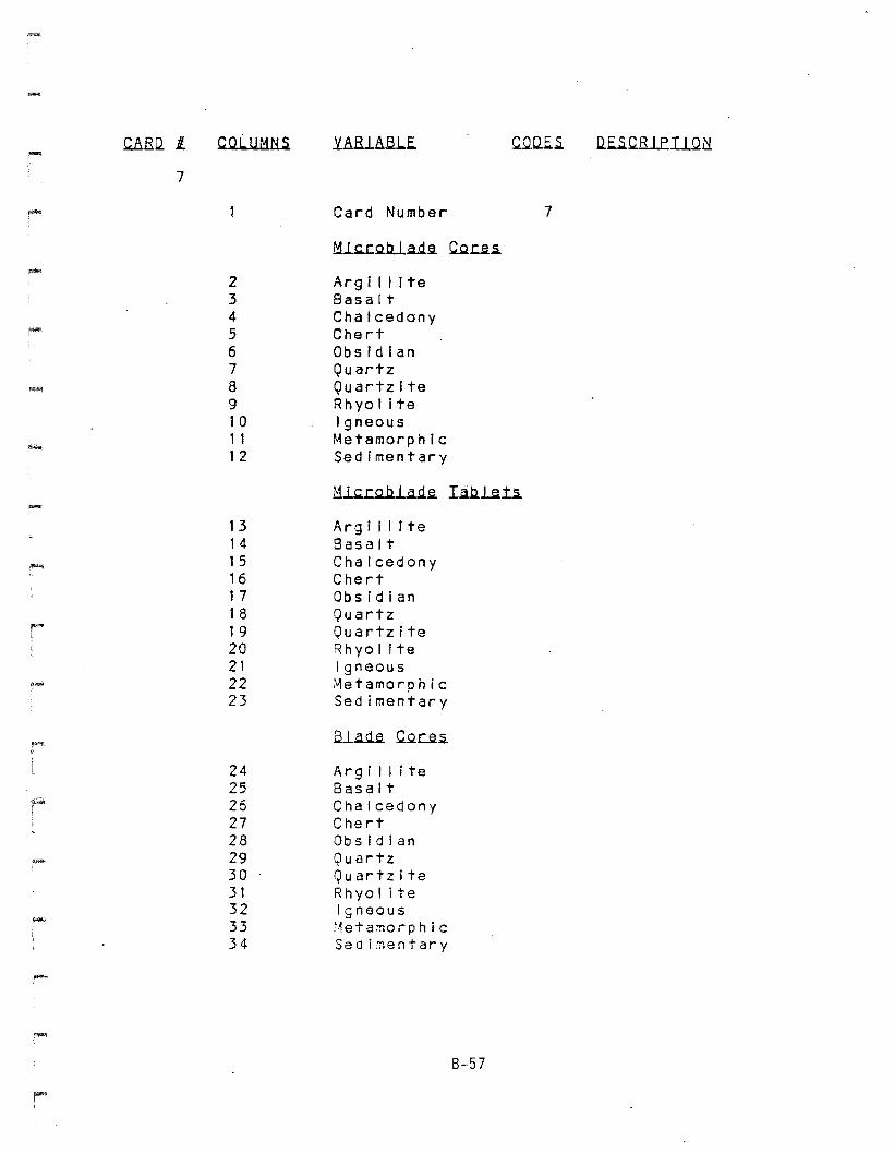
.c.ARQ.l CQL.UM~.s. Y~Rl~a.LE. .c..Q:Q.E..s. Q.E..s..c.R1EI1UNI~
7
~ Card Number 7
M..L~2ti.a.d.~ .c..Q.J:.~~
..-2 Arg I I I I te3 Basalt4 Chalcedony5 Chert6 Obsidian7 Quartz
r,~ 8 Quartzite9 Rhyolite10 Igneous11 Metamorphic12 Sed Imentar y
M~.b.l..a.d.~ Ia..b.tih-13 Arg ill I te14 Basalt
-~15 Chalcedony16 Chert17 Obsidian18 Quartz19 Quartzite20 Rhyo I I te21 Igneous22 :.letamorphic23 Sedimentary
al..~.~ .c..Q.c.~~
24 Arg i I lite25 Basalt26 Chalcedony27 Chert28 Obsidian29 Quartz30 Quartzite31 Rhyol ite32 Igneous33 i1 eta m0 r phi c34 Sedimentary
6-57
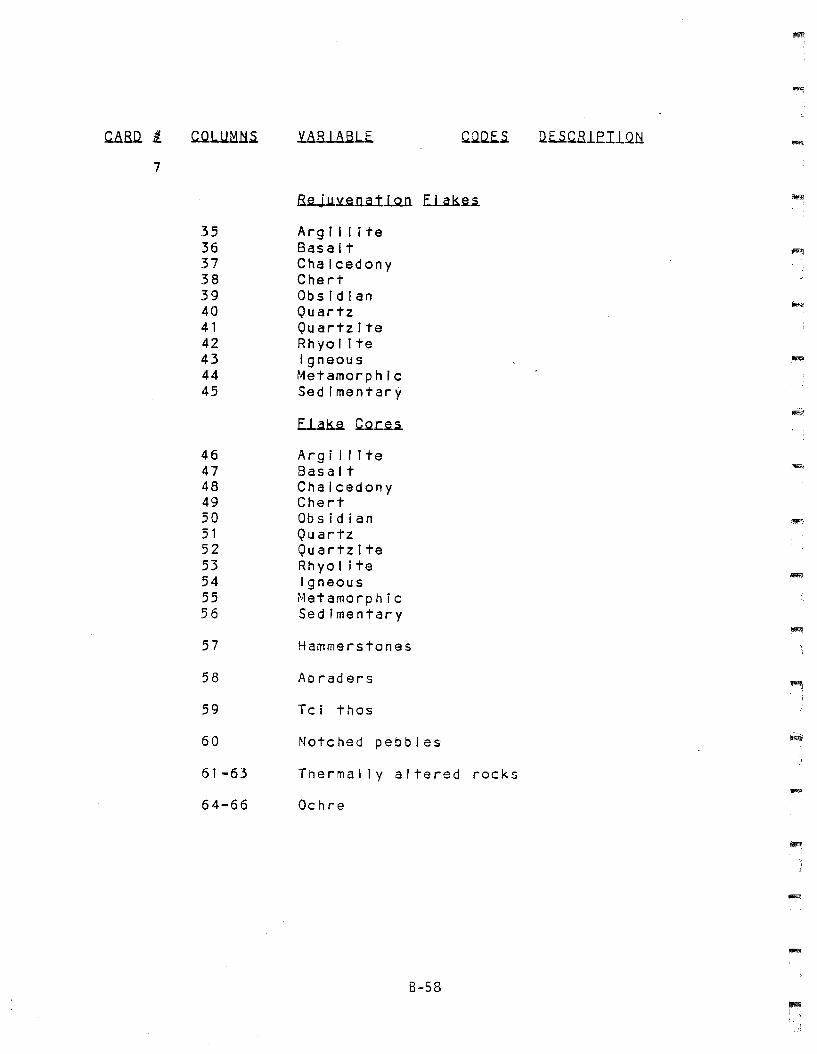
.c..aaD. /I..
7
C..QJ..llMH.s. Q.E..S.CR1E.Il.Qli
3536373839404142434445
4647484950515253S45556
57
58
59
60
61-63
64-66
Reju~~natlQfi E~ka~
Arg t I I I teBasaltChalcedonyChertObsidianQuartzQuartziteRh yo I I teIgneousMetamorphIcSedImentary
Arg I I I I teBasaltChalcedonyChertObsidianQuartzQuartziteRhyol itaIgneousr,let amo rp hi cSedimentary
Hammerstones
Abraders
Tel thos
Notched pebbles
Thermally altered rocks
Ochre
8-58
-
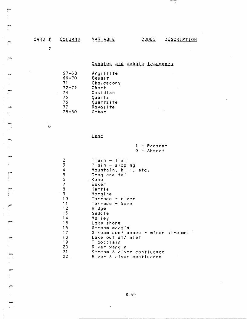
8-59
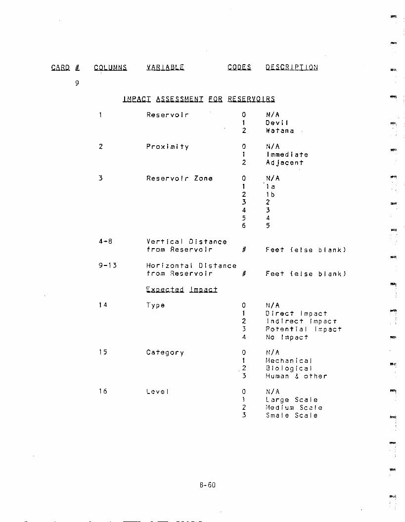
CARLl /L Ilf.-S.CR1EI1UU
9
-2
3
ReservoIr
Proximity
Reservoir Zone
o12
o12
a123456
N/ADev I IWatana
N/AImmediateAdjacent
N/A1 a1b2345
4-8
9-13
Vertical Distancefrom Reservoir #
Horizontal Distancefrom Reservoir #
Feet (else blank)
Feet (else blank)
14
15
16
E.~~1~.d. lm.Q.~1
Type
Category
Level
B-60
o1234
o123
o123
N/ADirect ImpactIndirect ImpactPotent i a I I rr.pactNo Impact
N/Al~echan i ca IBiologicalHuman &. other
N/ALarge Scale:,1e diu m Sc a IeSmale Scale
-
-
C.8.RD. Jl Y..8.Rl.8.51.f.
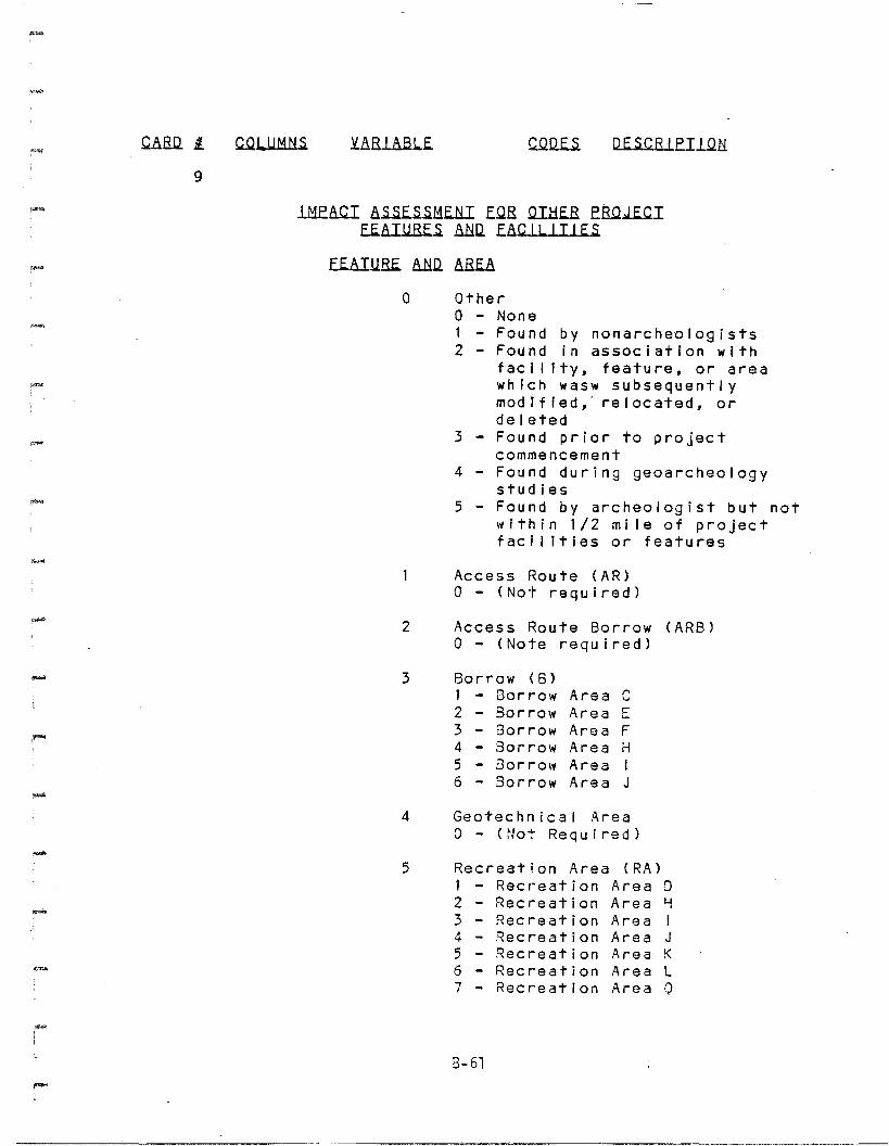
9
IM.E..8..CI .8.~f.~MElil E.QR QI.l::if.B fB..Q.J.E..cIEE..8..I.U.Ef..s. aND. EaC.L1..lIl..E..S.
Ef..8.IURE .8..llil aBf..8.
4
3
5
a 12
Access Route (AR)a - (Not required)
Access Route Borrow (ARB)a - (Note required)
Borrow (6)1 - Borrow Area C2 Borrow Area E3 Borrow Area F4 Borrow Area H5 Borrow Area I6 Borrow Area J
2
o OtherNonE:!Found by nonarcheologistsFound In association withfac Illty, feature, or areawhich wasw subsequentlymodIfied, relocated, ordelE:!tedFound prior to projectcommencementFound during geoarcheologystudiesFound by archeologist but notwithin 1/2 mile of projectfaci llties or features
3-
.....
-
4 Geotechnical Areaa - (Not Required)
5 Recreation Area (RA)1 234567
Rec r-eat jonRecreationRecreationRecr-eationRecreationRecr-eationRecr-eat ion
Area 0Area HArea IArea JArea KArea LArea Q
8-61
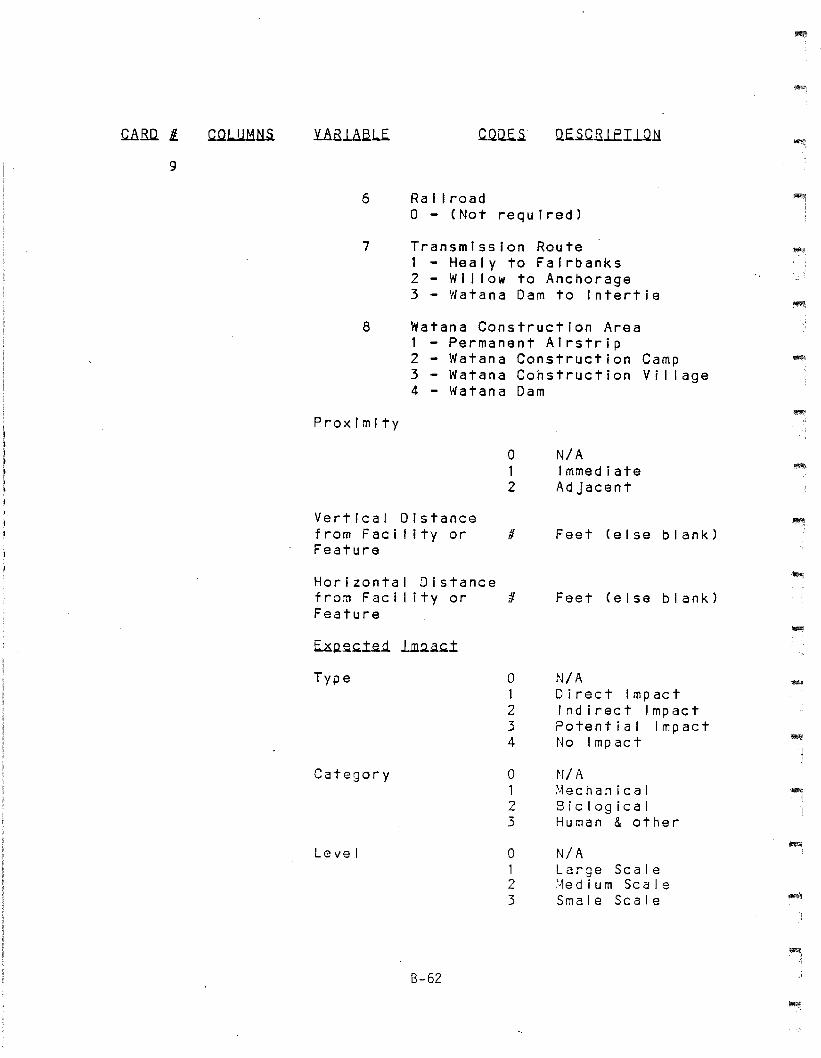
.cARD. II.
9
UR.L8.a.Lf. C.QQ.f..s. Uf..s.C.Rle.Il.QH
6 Ra I I roada - (Not required)
7
8
Transmission Route1 - Healy to Fairbanks2 - Wi I low to Anchorage3 - Watana Dam to Intertie
Watana Construction Area1 - Permanent Airstrip2 - Watana Construction Camp3 - Watana Construction Village4 - Watana Dam
~,
-.
ProximIty
VertIcal Distancefrom Faci I ity orFeature
a12
/I
N/AImmediateAdjacent
Feet (else blank)
-
HorIzontal Distancefrom Faci I ity or IIFeature
Feet (else blank)
Type
Category
Level
B-62
a1234
a123
a123
N/ADirect ImpactIndirect ImpactPotential ImpactNo Impact
N/A~·1echan Ica IBiologicalHuman & other
N/ALarge Scale>1e diu m Sc a J eSmale Scale
1!!Ol>l:
~~
~BO. fl CQLUM~.s. Y.8.B1Aalf. C.QU.E..s. UE..s.C.Ble.I1Qtl
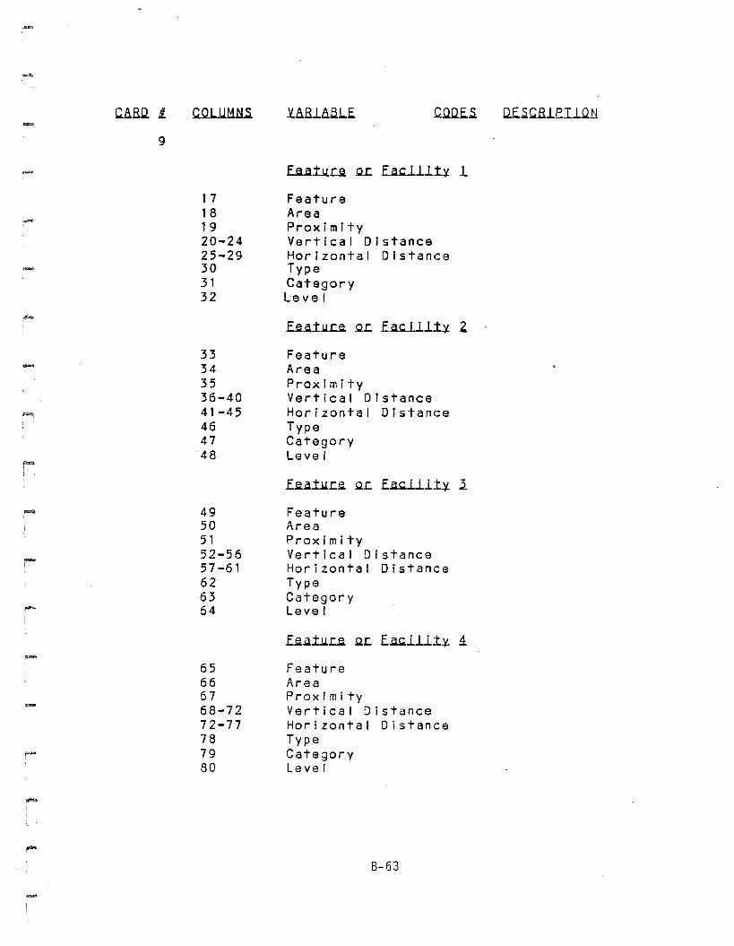
9
.uta.I.llJ:Ji QL: fac jiLt,¥. 1
17 Feature18 Area19 Proximity20-24 Vertical Distance25-29 Horizontal Distance
.-. 30 Type31 Category32 Leve I
f..e..a.t.llJ:Ji QL: E~lll.t,¥. .2.
33 Feature34 Area35 Proximity36-40 Vertical Distance41-45 Horizontal Distance46 Type47 Category48 Level
f..e..aI.llL:.e. QL: E.atiJ..lt,¥. l
49 Feature50 Area51 Proximity52-56 Vertical Distance57-61 Horizontal Distance62 Type63 Category
,-.. 64 Level
f..e..aI.lLJ:Ji QL: E.a~llLt,¥. 1- 65 Feature66 Area67 Proximity
~
68-72 Vertical Distance72-77 Horizontal Distance78 Type
~ 79 Category80 Level
B-63
-
....
-
APPENDIX C - TEPHRA ANALYSIS
APPENDIX C - TEPHRA ANALYSIS
C.1 - Introduction
Tephra (volcanic ash) layers were identified at most of the sites foundduring the cultural resources survey. At 1E~ast three, and possibly
four, tephras were identified in the field and samples were collected
from various sites within the study area. Analysis was conducted on
samples taken from terrestrial settings. TE!phr~s found in lacustrinesettings are discussed in Chapter 8.
The petrographic study discussed here was conducted to: 1) determinewhether the soil/sediments identified in the field as tephra were, infact, tephra; 2) characterize the mineralogy and glass shard morphology
of the tephra; and 3) determine the number of tephras present.
Successful discrimination of the tephras provided a method to correlateand date archeological components within the Susitna River valley.
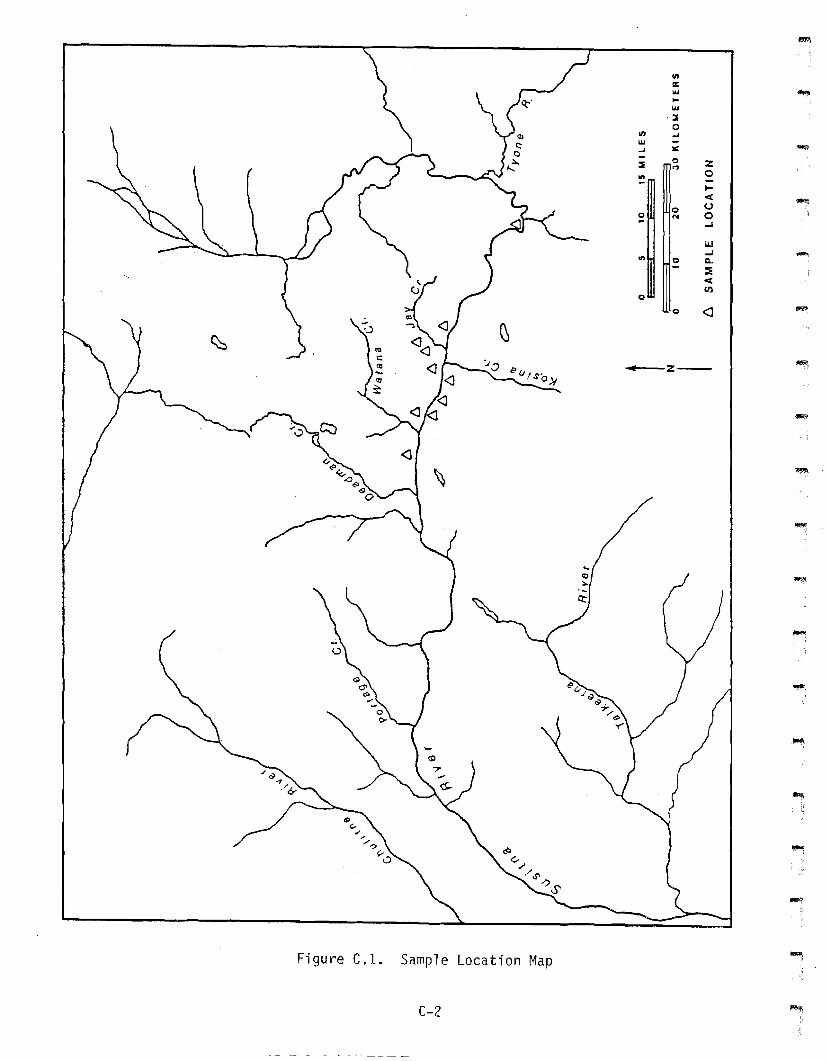
The 29 samples analyzed were selected from ten systematically tested
sites, distributed across 48 km adjacent to the Susitna River (FigureC.l). These specimens provided a representative suite of samples, both
stratigraphically and geographically within the project area.(Table
C.1). Analysis of these samples should accurately characterize the
tephras present in the valley.
C.2 - Analytical Methods
The samples were prepared following the procedure suggested bySteen-McIntyre (1977). The volume of material used and the color ofeach sample (when moistened) were recorded. The samples were thenrinsed several times in distilled water, and the suspended fines andfloating organic material were decanted off. Three to five times thesample's volume of sodium hypochlorite (household bleach) was then addedto each sample and the mixture heated in a boiling water bath for 15minutes to remove any organic cementing agents (Steen-McIntyre 1977).
C-1
eng:.... ........::I0
I/) -'UI --' :..:
I
:::E 0 ZM
~0~
< -0 u0 ... 0~ ...I
W...I -In 0 Q.
::i:<1Il
0
0 <J -
Figure C.l. Sample location Map
C-2
.....-z- --
.....
-
-
.....I
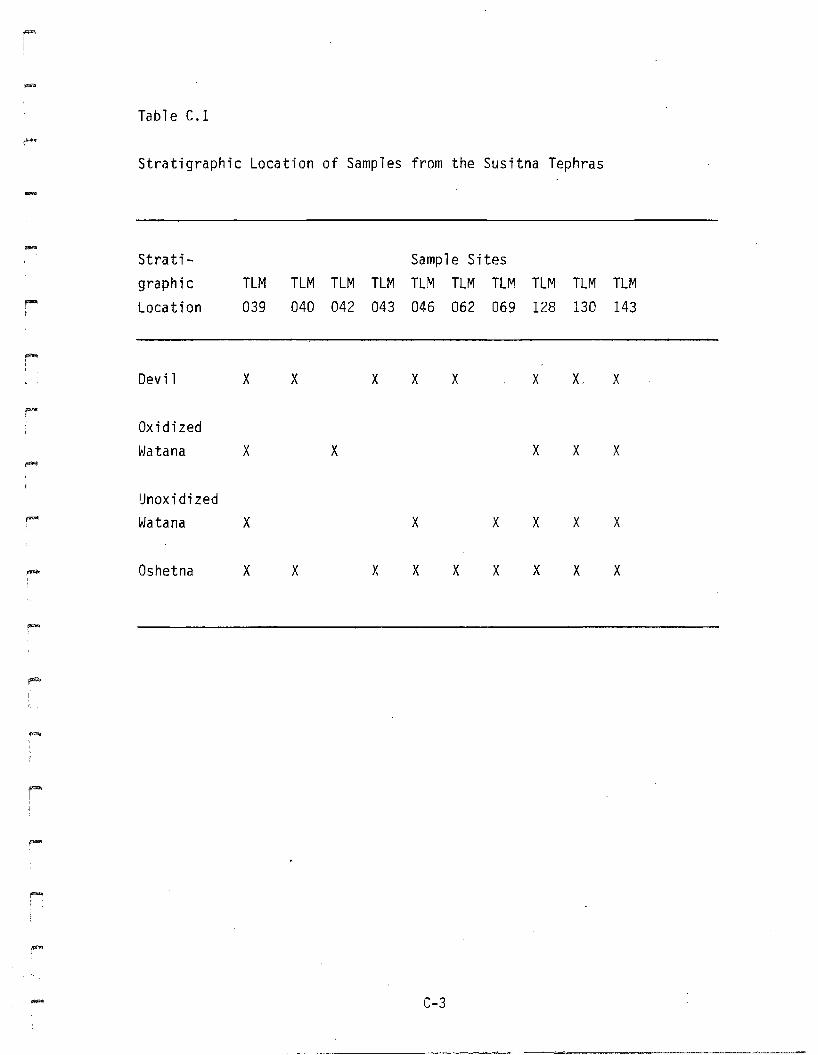
Table C.1
Stratigraphic Location of Samples from the Susitna Tephras
Stratigraph ic
Location
Sample SitesTLM TLM TLM TLM TLM TLM TLM TLM TLM TlM
039 040 042 043 046 062 069 128 130 143
Devil X X X X X X X. X
~
Oxidized~)atana X X X X X-UnoxidizedWatana X X X X X X
,""" Oshetna X X X X X X X X X
.-
..... C-3
The liquid was then decanted off and the sample was rinsed once w{thdistilled water. Suspended fines were again decanted off. A solution
of 6 N hydrochloric acid was then added to the samples to dissolve iron
oxide cement. After the acid was decanted off, the sample was rinsed
twice with distilled water and air dried. After drying, the samples
were sieved using 16 mesh (1 mm), 32 mesh (0.5 mm), 60 mesh (0.25 mm),and 250 mesh (0.062 mm) sieves. The volume of each size fraction wasrecorded. The sample size used in the petrographic analysis consisted
of grains between 60 and 250 mesh (0.25 and 0.063 mm). This fractionwas washed in distilled water in a sonic cleaner for 10 to 15 minutes.
The procedure was then repeated using acetone, and, then the sample was
air dried. Once dry, this fraction was again screened using a 250 meshsieve. The -250 mesh fraction was discarded, while the +250 mesh
fraction was stored for analysis.
Grain mounts were made by mixing a small portion of each sample with
several drops of histoclad on a glass slide, and allowing the histocladto set. Each sample was mixed thoroughly before a small scoop of it wastaken in an attempt to get a representative split.
Each sample was examined under binocular and petrographic microscopes.Four hundred to six hundred grain counts were made of 16 samples using
Galehouse's (1969) area method. All grains within the field of view at100x magnification were counted, and each sample had four fields of view
counted. The percentage of mineral grains in each sample was thencalculated.
Nineteen samples from the Devil, Oxidized Watana, and Unoxidized Watanatephras had 98 to 160 grain counts of their glass fraction tocharacterize the glass shard morphology of the tephras. Three sampleswere counted three times to test the reproducibility of the graincounts~ The results are listed in Table C.2 and suggest that the graincounts are accurate to within ±6 percent.
C-4
-
-I
Table C.2
Reproducibil ity of Glass Shard Counts
Count 1 Count 2 Count 3% % % % % % Standard
F'" Sample Scoria Vesic. Scoria Vesic. Scoda Vesic. Mean Deviation
~
ATC-0006 28.8 71.1 43.8 56.2 42.2 57.8 38.3 6.7
ATC-0015 28.7 71.3 50.5 49.5 51.5 48.5 43.6 10.5
- ATC-0019 86.6 13.4 91.1 8.9 89.4 10.6 89.04 1.8
Where %scoria = percent scoriaceous glass shards; % vesic. = percentvesicular glass shards.
,~
I
C-5
Eight samples were examined using a scanning electron microscope (SEM)
to make a high magnification study of glass shard morphology. The eight
samples were glued to aluminum stubs using a thinned carbon adhesive,and
then coated with a thin layer of gold using an SPI sputter coater. The
coater was run for eight minutes to reduce the amount of sample
charging. Samples were scanned at lOOx and then photographs were taken
at higher magnification (220x to lOOOx).
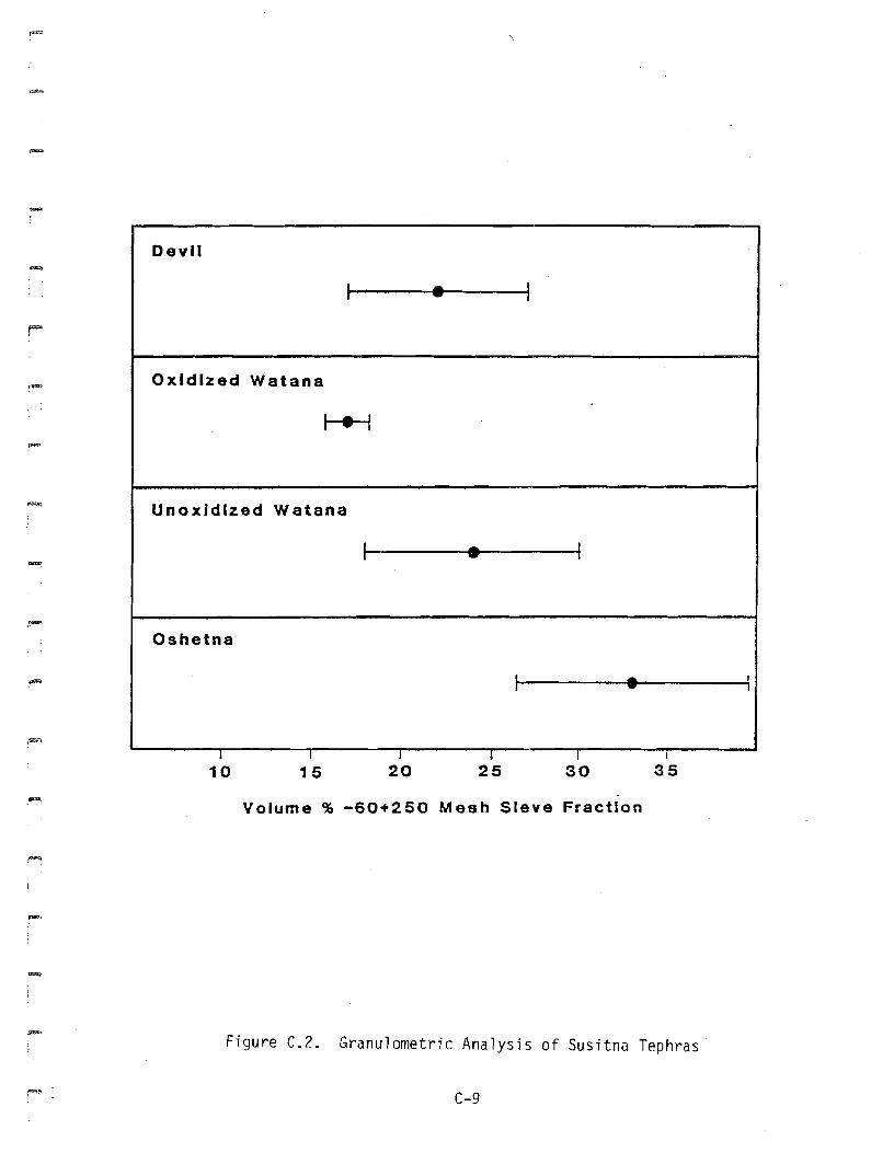
C.3 - Granulometric Analysis
Granulometric analyses were conducted on 15 samples. Many of the
samples were too small (less than 5 milliliters) to conduct acceptable
analyses. The results are listed in Table C.3 and are shown graphically
in Figure C.2. The small standard deviation of the Oxidized Watana
tephra is due to the small number of samples, and not to high precision
of the data. The analyses indicate that the tephras are dominated by
the fine silt and clay-sized fraction (-250 mesh). The coarse sand
fraction generally represented an insignificant portion of the sample.
C.4 - Appearance Under Binocular Microscope
Glass appears as white grains under a binocular microscope. Transparent
and translucent grains exhibit both cleavage surfaces and conchoidal
fracture, suggesting that a portion of the transparent grains arefeldspar.
(a) Devil Tephra
This tephra is dominated by white angular grains, followed in decreasingabundance by transparent and translucent grains, green laths, and opaqueminerals. The white glass commonly mantles the green laths.
(b) Oxidized Watana Tephra
White glass shards are the dominant grain followed by transparent and
translucent grains, green laths, and opaque minerals. White glass
C-6
--
-
-
-
Table C.3.
Grain Size Analysis for 15 Susitna Tephras
..,...
Sample #
Vol. %
+60 meshVol. %
-60 +250 mesh
C-7
Vol. %
-250 mesh
Stratigraphic
Location

Table C.3. (Continued)
--
Sample #
ATC-0019
ATC-0025
ATC-0028
Vol. %+60 mesh
0.0
4.3
3
Vol. %
-60 +250 mesh
36.9
30.2
19.8
C-8
Vol. %
-250 mesh
63.1
65.5
77.2
Stratigraphic
Location
u. Watana
Devi 1
Devil
""'"
Devil
I • I
Oxidized Watana
I • I
Unoxldlzed Watana
I • I
Oshetna
r- • I
I I I I , I
10 15 20 25 30 35
,~"
Volume % -60+250 Mesh SIeve Fraction
Figure C.2. Granulometric Analysis of Susitna Tephras
C-9
(c)Unoxidized Watana Tephra
The Unoxidized Watana appears quite similar to the Oxidized Watana.
Biotite is also a minor constituent of this tephra.
(d) Oshetna Tephra
Transparent and translucent fragments are the dominant grains, followedby green crystal fragments, and opaque minerals. White glass is a rare
constituent of the tephra. The green crystals are generally short
angular flakes without glass mantles. Biotite is more abundant in this
tephra than in the others.
C.s - Mineralogy
(a) Hornb1ende
Two varieties are present: 1) euhedral to subhedral laths having greento olive green, or dark green pleochroism, and 2) subhedral to anhedral
fragments with green to blue-green pleochroism. The euhedral to
subhedral green laths are the dominant type in the Devil, Oxidized
Watana, and Unoxidized Watana tephras, while the blue-green variety iscommon only in the Oshetna tephra. The green laths are commonly mantledby glass and usually contain inclusions of opaque minerals. Theblue-green variety lacks attached glass, and is generally free of opaque
inclusions. Both amphiboles are biaxial negative and exhibit sometwinning.
(b) Orthopyroxene
Orthopyroxene occurs as biaxial negative hypersthene. The hyperstheneis subhedral to euhedral and is commonly mantled by glass. This is trueeven in the glass-poor Oshetna tephra. The phenocrysts range between0.02 and 0.3 mm in length, are length slow, and have either pale green
to pink, or pale green to yellow, pleochroism. The hypersthene commonlyoccurs as interpenetration twins. Inclusions in the phenocrysts include
C-10
-
.~
opaque minerals and smaller crystals of orttlOpyroxene. The mineral isuncommon in the three upper tephras, and only reaches relatively
abundant levels in the Oshetna tephra.
(c) Plagioclase
Two populations of the mineral are present. The most abundant varietyconsists of anhedral, angular to subangular, grains lacking attached
glass. The birefringence increases towards the center of these grainsindicating a platy habit which is thickest at the middle. Zoning is
common, while twinning is .not. The lack of albite twins made itimpossible to estimate anorthite composition.
The second variety is less common and is characterized by lowbirefringent euhedral to subhedral grains, mantled by glass, and having
a1bite and carl sbad twi ns. Concentri c and asci 11 atory zoni ng are common
in this variety of plagioclase. Compositional estimates, using theMichel-Levy method (Kerr 1977), ranged between An 25 and An41 for theDevil tephra, An 25 and An 49 for the Oxidized Watana, An 23 and An30 for
the Unoxidized Watana, and between An30 and An32 for the Oshetna tephra.
(d) Opaque Minerals
These minerals generally occur as subhedral to anhedral grains less than
0.2 mm in diameter. Opaque minerals are common inclusions in glass,plagioclase, orthopyroxene, and hornblende. The cubic shape of the
grains suggests that they are magnetite.
(e) Quartz
Quartz is present in the tephra in unknown quantities and is recognizedby its conchoidal fracture, low birefringence, low relief, and uniaxialpositive interference. It appears as anhedral angular grains lackingglass mantles. The similarity in appearance between quartz and theplagioclase lacking glass mantles resulted in the two grains beinglumped together in the grain counts.
C-11
(f) Minor Accessory Minerals
Biotite occurs as anhedral, subangular to subrounded, red-brown to
yellow-brown pleochroic grains. It is a rare mineral in the Oxidized
Watana, Unoxidized Watana, and Oshetna tephras. None of the grains seenhad any attached glass. Clinopyroxene, zircon, and apatite are alsopresent in trace amounts in the four tephras.The clinopyroxene is
characterized by its pale green nonpleochroic color in plane light, itsbiaxial positive interference and inclined extinction. It is subhedral
to anhedral and is most common in the Oshetna tephra. Zircon is presentas anhedral to euhedral grains. It is recognized ?y its very highrelief and birefringence, parallel extinction, and its uniaxial positive
interference. None of the zircon has any attached glass. Apatite
occurs as small inclusions in plagioclase phenocry~ts.
C.6 - Grain Count Analyses
Sixteen samples had between 350 and 700 grains counted to get anaccurate estimate of the percentage of different minerals in eachsample. The samples were grouped according to stratigraphic position
and the mean and standard deviation for each mineral were calculated.
The mean values are listed in Table C.4. Figures C.3, C.4, and C.5compare the mean and deviation for each mineral in all four tephras.
The only case where the mineralogy is different is in the Oshetnatephra, where the percentage of glass shards is much lower, and thepercentages of plagioclase and quartz much higher, than in the other
tephras.
C.7 - Glass Shard Morphology
The glass shards in these tephras have morphological characteristicstypical of rhyolitic glasses (Heiken 1972). They are vesicular, withthe shape of the vesicles controlling the shape of the shards. Twotypes of glass shards were observed: 1) grains with relativPly fewvesicles resulting in the glass appearing transparent and angular in
plane light, and 2) scoriaceous grains with subangular to subrounded
C-12
--
.....
-
Table C.4
Mean Percentage Values for Grain Counts of Susitna Tephras
Tephra Hb Bio Opx Cpx Opq P1/Q Pl/G Zirc Gl Lith
,Devil 14.0 0.1 0.6 0.0 2.5 26.4 7.2 0.2 48.4 0.5
Oxidized.-
Watana 11. 4 0.4 0.6 0.1 2.9 41.1 8.5 0.3 34.2 0.5
~
Unoxidized
Watana 15.1 0.1 0.2 0.0 3. 1 21.9 12.9 0.0 46.3 0.3
Oshetna 9.4 0.3 2.8 0.3 4.2 75.6 2.3 0.6 3.1 1.3
-,Hb = Hornblende
r-! Bio = Bi otite
Opx = Orthoproxene
Cpx = Cl i nopyroxeneOpq = Opaque minerals
P1/Q = Plagioclase an~ quartz lacking glass mantles
Pl/G = Plagioclase with glass mantlesZirc = Zircon
G1 = GlassLith = Li thi c fragments
r""'"I
C-13
Hornblende Opq. Minerai. Plag. w/gl888
-
-10510
I • tI--e-4
I-e-1
I-e1~
l--e-1
~I • I
~
I • II • I
~
II I I I I I I I
Devil
Oshetna
OxidizedWatana
UnoxldlzedWatana
Percent of grains
Figure C.3. Percentages of Minerals in the Susitna Tephras
C-14
-cCDu..CDC.
.,.,a:I
CD
CDC-.:II:Ua:I
-Ca:I
E
oM
oU)
oco
o'I"'"
H..eao :::~ 0
"CCa:I
CDCD
"caUQ
CD
=C.
.,c
o ea10 ..
"
,
-r-
I-
0
I-_....
to-
--
r-
4~l-
tt-
ea-. c
Iea eac -a:I a:I t-- ::a:I
:: "CCD
"C H =CD - C"CN - - I-- - )( CD- "C> - 0 .cCD >< C
.,C 0 ::;) 0
,...,
.-
Figure C.4. Percentage of Plagioclase and Quartz Grains Lacking GlassMantles in the Susitna Tephras
- C-15
-
-5040302010
DeYIl
I • I
Oxidized Watana
1 • I
Unoxidlzed Watana
I • I
Oshetna
re-i
t I I I I
Percent Glass Shards
Figure C.5. Percentage of Glass Shards in the Susitna Tephras
C-16
I"'"II
,~
~I,
~I
;-I
shapes. This second type of glass shard appears brownish in plane lightbecause the numerous small vesicles tend to refract the light rather
than allowing it to pass through relatively undisturbed. Vesicle shapes
range from tubelike to spherical.
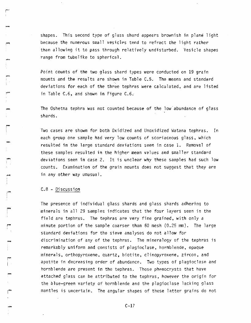
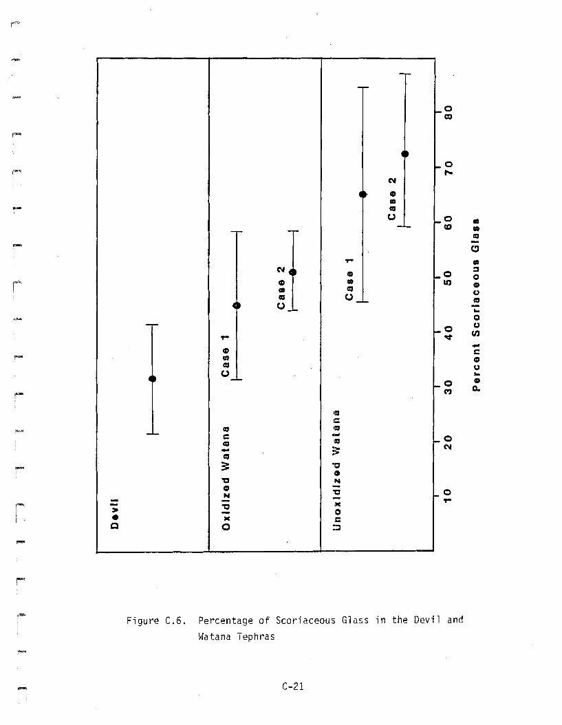
Point counts of the two glass shard types were conducted on 19 grainmounts and the results are shown in Table C.5. The means and standarddeviations for each of the three tephras were calculated, and are listedin Table C.6, and shown in Figure C.6.
The Oshetna tephra was not counted because of the low'abundance of glass
shards.
Two cases are shown for both Oxidized and Unoxidized Watana tephras. Ineach group one sample had very low counts of scoriaceous glass, which
resulted in the large standard deviations seen in case 1. Removal of
these samples resulted in the higher mean values and smaller standarddeviations seen in case 2. It is unclear why these samples had such lowcounts. Examination of the grain mounts does not suggest that they are
in any other way unusual.
C.8 - Discussion
The presence of individual glass shards and glass shards adhering tominerals in all 29 samples indicates that the four layers seen in thefield are tephras. The tephras are very fine grained, with only aminute portion of the sample coarser than 60 mesh (0.25 mm). The large
standard deviations for the sieve analyses do not allow fordiscrimination of any of the tephras. The mineralogy of the tephras isremarkably uniform and consists of plagioclase, hornblende, opaque
minerals, orthopyroxene, quartz, biotite, clinopyroxene, zircon, andapatite in decreasing order of abundance. Two types of plagioclase andhornblende are present in the tephras. Those phenocrysts that have
attached glass can be attributed to the tephras, however the origin forthe blue-green variety of hornblende and the plagioclase lacking glass
mantles is uncertain. The angular shapes of these latter grains do not
C-17
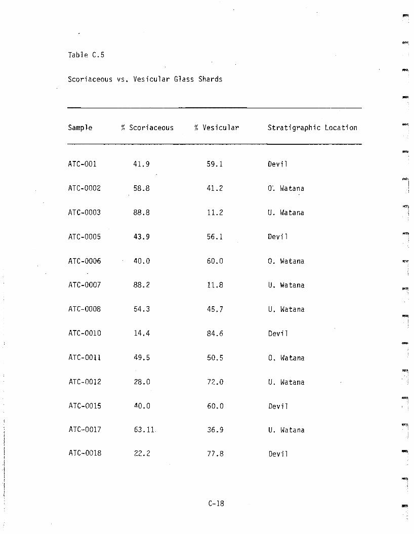
Table C.5
Scoriaceous VS. Vesicular Glass Shards
Sample % Scod aceous % Vesicular Stratigraphic Location
""'"ATC-OOI 41.9 59.1 Devi 1
ATC-0002 58.8 41.2 0'. Watana
ATC-0003 88.8 11.2 U. Watana
ATC-0005 43.9 56.1 Devil
ATC-0006 40.0 60.0 O. Watana
ATe-ODD? 88.2 11.8 U. Watana
ATC-0008 54.3 45.? U. Watana-.
ATC-OOIO 14.4 84.6 Devil
ATC-OOll 49.5 50.5 O. Watana
ATC-0012 28.0 72.0 U. Watana
ATC-0015 40.0 60.0 Devil
l!I!"\ATC-OOl? 63.11 36.9 U. Watana I
I
ATC-0018 22.2 77 .8 Devil ""'"J
"""
C-18
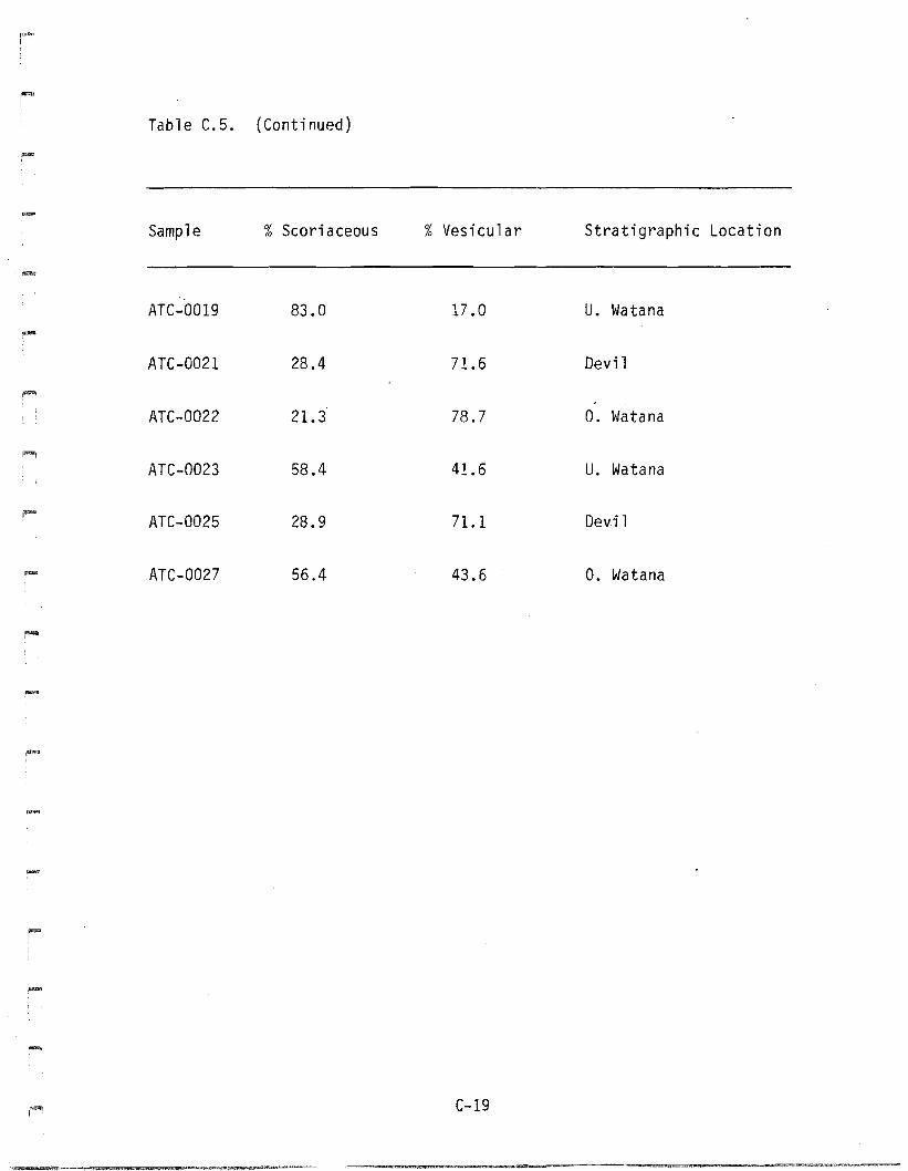
Table C.5. (Continued)
.....Sample %Scoriaceous %Vesicular Stratigraphic Location
~
ATC-0019 83.0 17.0 u. Watana
ATC-0021 28.4 71.6 Devil
;~
ATC-0022 21.3 78.7 O. Watana
ATC-0023 58.4 41.6 U. Watana
ATC-0025 28.9 71.1 Devi 1
ATC-0027 56.4 43.6 o. Watana
--""'"
C-19
Table C.6
Means and Standard Deviations for Devil, Oxidized Watana, and Unoxidized
Watana Tephra Glass Shard Counts
Tephra No. of Samples Used Mean Standard Deviation
Devil 7 31.5 10.0
O. Watana (1) 5 45.2 13.6
O. Watana (2) 4 51. 2 7.3
U. Watana (1) 7 66.3 20.5
U. Watana (2 ) 6 72.6 14.4
C-20
-
-....
0
-0to-
N
0- ~
CD«a(J - 0 •-.... -J_ CQ •-,...
a::l
0'P"' •N ~,~ 0
~
'- 0~ • 10 4)• «a u«a (J _ ....
0(J __ «J
.....- Q
i -- UI - 0 en
'P"' ~ -~ cca ~«J U.. (J __ ..
0 4)
"'" 0.M
110Ie:
~ «J 111:1-'- C ....
a::l IlI:l - 0- ;;: Nca
.- := 'cIII
~ IN~ --N -C ... 0- - -- 'P"'
r' - ~:lI(
~ - 10i • ~ C
C 0 :~
Figure C.6. Percentage of Scoriaceous Glass in the Devil andWatana Tephras
C-21
indicate much, if any, transport, yet the differences between them and
the phenocrysts which do have glass mantles suggest a different origin.
Similar problems arise in interpreting the origin of the quartz,zircon,
and biotite. Without attached glass it is unclear whether these
minerals represent detrital contaminants or primary volcanic material.
Of the four tephras, only the Oshetna can be distinguished on the basis
of mi nera logy. Fi gures C.3 and C.4 show that it has a much hi gher
percentage of plagioclase and quartz, and a much lower percentage of
glass shards, than any of the other tephras.
Baseq on glass morphology, the Devil and Unoxidized Watana tephras can
be distinguished with a fair degree of confidence. Table C.4 shows that
all of the Devil tephra samples have less than 50% scoriaceous glass
shards, while 57% of the Unoxidized Watana tephra have greater than 60%
soriaceous glass shards, and 86% have greater than 50% soriaceous glass
shards. The Oxidized Watana tephra has percentages of scoriaceous glass
shards which overlap the fields of the two other tephras.
C.9 - Conclusions
Three out of the four tephras can be distinguished based on thispetrographic study. While stratigraphic evidence suggests that the
Oxidized Watana tephra is a separate unit from the Unoxidized Watana and
the Devil tephras, the petrographic evidence is unclear. The remarkable
mineralogic similarities between the three upper tephras suggest that
they are derived from the same volcanic vent. If this is the case,
geochemical studies of the glass shards and phenocrysts will probably be
needed to clarify the distinctions between the three upper tephras. TheOshetna tephra is clearly distinguishable from the other tephras due tothe differences in mineralogy and the proportion of glass shards. These
differences may be due to its greater age or a different source. It isgenerally agreed that tephra correlation must be based upon several
criteria, and not on a single criterion (Westgate and Gorton 1981).
Stratigraphic and petrographic data are now available for the Susitna
tephras, and geochemical studies of the tephras would aid in clarifying
C-22
'""",
~,
-,
-
~
,
....
-
the distinctions between tephra units. Numerous authors have used
geochemistry to distinguish between tephras, as well as identifying
several tephras in a layer which was thought to be a single unit (Smith
and Westgate 1969; Izett 1970 et al.; Westgate 1977; Scheidegger et al.
1978; Westgate and Evans 1978; and Larsen 1981).
In addition to the geochemical analyses~ detailed petrographic work
would probably reduce the variance in the analyses that have been
conducted and may clarify the distinctions between the three upper
tephras.
C.10 - Archeological Significance
The petrographic analysis largely agrees with the field evidence that
there are three~ and probably four~ tephra units in the Susitna River
valley. This corroborating evidence should give a high degree of
confidence to the correlation of components from different sites which
are found between the same tephra units. These analyses may also aid
correlation of components associated with tephra in other parts of
south-central Alaska, where the tephras can be shown to be identical to
the Susitna tephras.
C-23


![bdf}nL, tgxF' u08sL k|b]z, g]kfn gu/ kfZj{lrq](https://img.pdfslide.net/doc/110x75/6216cdbf9e73c75660770fa3/bdfnl-tgxf-u08sl-kbz-gkfn-gu-kfzjlrq.jpg)


![b`gu b]juihI>>^ey feZ^r c]jmiiu IH>ML](https://img.pdfslide.net/doc/110x75/62b493bc0645b76c48481018/bgu-bjuihigtgtey-fezr-cjmiiu-ihgtml.jpg)