Embed Size (px)
Citation preview
B. R. Ambedkar, Regional Geoscience Laboratories, WON Basin, ONGC, Vadodara
Email: [email protected]
10th Biennial International Conference & Exposition
P 170
Lithobiostratigraphic Correlation and Paleoenvironment of Hazad Pays in
Eastern Part of Jambusar – Broach Block, Cambay Basin
*Aswal, H. S., K. K. Das, U. N. Yadava, K. K. Nayak, Prathimon, P. T., P. B. Rana
Summary
In Jambusar-Broach block there are numbers of hydrocarbon bearing pays in Hazad member of Ankleshvar Formation that
form NE-SW and E-W prograding delta lobes. Due to persistent sediment supply and changing coast line during deposition of
Hazad Member under a normal regressive set up, the overall geometry of sand lobes has wide lateral spread. Towards the NE
part of Gandhar field and close to eastern rising flank, younger Hazad pays are inconspicuous due to poor development
resulting in ambiguity in their correlation and nomenclature. A biostratigraphic approach based on biochronohorizons as
bounding surface within Ankleshwar Formation has been adopted for correlation and depositional model of GS units have
been proposed in the area covering NE Gandhar, Jambusar, Gajera, Amod, North Sarbhan, Matar, Dabka and Kural. A
dichronous and persistent hiatus spanning 2 MY(51/49 MY) equating C II 30 has been mapped between the YCS and Hazad
Member across basin as evident by absence of GS-1, 2 and 3 units. Similarly, the top of Hazad Member is dated 44MY (Middle
Eocene) marking the onset of transgression (44-42 MY) represented by Kanwa shale. To establish correlatibility with in Hazad
Member, eleven flooding surfaces recognized in well G#CI and tide across to propose micro level genetic correlation of GS
units. The depositional model of GS-4 and 5 units indicate a N-S trending narrow prograding delta lobe which further spreads
out towards east and west depositing GS-6 to 9 units, prominent being along the wells G#CI, EFF & EB. There is to a certain
extent restriction in delta development during GS-9 and 10 due to paucity of sediments supply. A prominent tidal flat has
developed in the area during deposition GS-12 unit, as evident from increasing argillaceous facies, occurrence of coal and
restricted development of sandstone in G#CI & EB as being deposited as tidal channel. The study is helpful in standardizing
the biohorizons and flooding surfaces, and establishes litho-bio correlation in the area for delta modeling.
Keywords: Cambay Basin, Data Interpretation
Introduction
The Broach depression in southern Cambay Basin lies
between Dadhar River in the north and Narmada River in
the south. The depression initially developed at the end of
the Mesozoic simultaneous to the formation of Cambay
graben. Rapid sedimentation during the Paleogene, topped
with deltaic sequence acted as basin fill and renewed active
subsidence with slight eastward shift in the depocenter
during the Neogene. The rising flanks of this depression
developed into suitable locale for potential hydrocarbon
accumulations. Due to development of multiple reservoirs
within the Paleogene section, the area remained
prospective for active hydrocarbon exploration. After the
recent discoveries in Matar and nearby areas towards the
north, a number of prospects were explored for their
hydrocarbon prospectivity. Gandhar field represents a
combination trap on the northwestern rising flank of
Broach depression, wherein updip wedging of deltaic sand
units of Hazad Member have entrapped large accumulation
of hydrocarbons. The Hazad member has 12 main sand
units (GS1-12) and these are further subdivided into 19
sands mainly on the basis of electrofacies correlation and
their production testing data suggest that these sands have
different hydrodynamic continuities. Out of the 12 main
sand units, the GS-7 and 10 have not been found
hydrocarbon bearing. From the electrofacies correlation, it
appears that most of these sand bodies are fairly continuous
and spread over a large area. However, the fluid
distribution and integrated seismic analysis suggest that
majority of Hazad sands are of discontinuous nature, thus,
it becomes significant to establish the exact geometry of
these pay sands for successful exploration and
development.
Objective
The objectives of the study is dating and demarcation of
litho-biofacies to establish depositional environment and
correlatibility of pay zones of Hazad sands in the area
2
covering North Gandhar, Jambusar, Dabka, Matar, Amod,
Kural, Gajera and N. Sarbhan fields.
Material and Method
The laboratory data from twenty two wells have been
considered to establish biostratigraphy and
paleodepositional environments of Hazad sediments and
integrated with electologs and basic principles of sequence
stratigraphy for correlation and in combination with
process sedimentology to understand the depositional
setup and distribution patterns of the pay sand units.
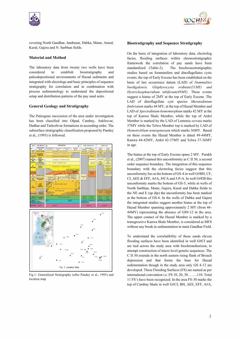
General Geology and Stratigraphy
The Paleogene succession of the area under investigation
has been classified into Olpad, Cambay, Anklesvar,
Dadhar and Tarkeshvar formations in ascending order. The
subsurface stratigraphic classification proposed by Pandey
et al., (1993) is followed.
Fig.1: Generalized Stratigraphy (after Pandey et al., 1993) and
location map
Biostratigraphy and Sequence Stratigraphy
On the basis of integration of laboratory data, electrolog
facies, flooding surfaces within chronostratigraphic
framework the correlation of pay sands have been
standardized (Table-2). The biochronostratigraphic
studies based on foraminifera and dinoflagellates cysts
events; the top of Early Eocene has been established on the
basis of last occurrence datum (LAD) of Nummulites
burdigalensis, Glaphyrocysta ordinate(51MY) and
Hystrichosphaeridium tubiferum(49MY). These events
suggest a hiatus of 2MY at the top of Early Eocene. The
LAD of dinoflagellate cyst species Muratodinium
fimbriatum marks 44 MY, at the top of Hazad Member and
LAD of Apectodinium homomorphum marks 42 MY at the
top of Kanwa Shale Member, while the top of Ardol
Member is marked by the LAD of Lentenia serrata marks
37MY while the Telwa Member top is marked by LAD of
Homotryblium tenuispinosum which marks 36MY. Based
on these events the Hazad Member is dated 49-44MY,
Kanwa 44-42MY, Ardol 42-37MY and Telwa 37-36MY
in age.
The hiatus at the top of Early Eocene spans 2 MY. Parakh
et al., (2007) named this unconformity as C II 30, a second
order sequence boundary. The integration of this sequence
boundary with the electrolog facies suggest that this
unconformity lies at the bottom of GS-4 in well G#BH, CF,
CI, AEE & EFF, A#A, J#CA and J-P-A. In well G#EB this
unconformity marks the bottom of GS-5, while in wells of
North Sarbhan, Matar, Gajera, Kural and Dabka fields to
the NE and E (up dip) the unconformity has been marked
at the bottom of GS-6. In the wells of Dabka and Gajera
the integrated studies suggest another hiatus at the top of
Hazad Member spanning approximately 2 MY (from 46-
44MY) representing the absence of GS9-12 in the area.
The upper contact of the Hazad Member is marked by a
transgressive Kanwa Shale Member, is considered as MFS
without any break in sedimentation in main Gandhar Field.
To understand the correlatibility of these sands eleven
flooding surfaces have been identified in well G#CI and
are tied across the study area with biochronohorizon, to
attempt construction of micro level genetic sequences. The
C II 30 extends in the north eastern rising flank of Broach
depression and that forms the base for Hazad
sedimentation though in the study area only GS 4-12 are
developed. These Flooding Surfaces (FS) are named as per
international convention i.e. FS 10, 20, 30……..110. Total
11 FS’s have been recognized. In the area FS-30 marks the
top of Cambay Shale in well G#CI, BH, AEE, EFF, A#A,
3
J#CA, and J-P-A, FS-40 in G#EB and GJ#D. In North
Sarbhan, Matar, Kural and Dabka fields FS-50 marks the
top of Cambay Shale (Table -3).
The depositional patterns of these sequences suggest that
the Hazad Member may have been deposited in low stand
normal regressive set up (Fig.17) in which the younger
sediments keep onlapping the unconformable surface and
above this surface the Hazad sediments are deposited as
Low Stand Normal Regressive aggradation followed by a
transgression represented by Kanwa Shale.
Lithofacies, Texture and Depositional Model of
Hazad Sands
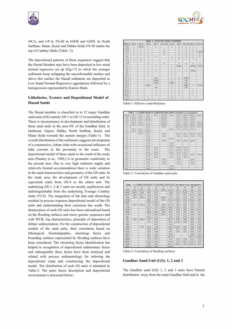
The Hazad member is classified in to 12 major Gandhar
sand units (GS) namely GS-1 to GS-12 in ascending order.
There is inconsistency in development and distribution of
these sand units in the area NE of the Gandhar field, in
Jambusar, Gajera, Dabka, North Sarbhan, Kural, and
Matar fields towards the eastern margin (Table-1). The
overall distribution of the sediments suggests development
of a constructive, lobate delta with occasional influence of
tidal currents in the proximity to the coast. The
depositional model of these sands to the south of the study
area (Pandey et al., 1989,) is in geometric conformity to
the present area. Due to very high sediment supply and
relatively limited accommodation there is wide variation
in the sand characteristics and geometry of the GS units. In
the study area, the development of GS units and its
equivalent starts from GS-4 as the oldest unit. The
underlying GS-1, 2 & 3 units are mostly argillaceous and
indistinguishable from the underlying Younger Cambay
shale (YCS). The integration of lab data and electrologs
resulted in process response depositional model of the GS
units and understanding their extension due south. The
demarcation of each GS units has been rationalized based
on the flooding surfaces and micro genetic sequences and
with WCR, log characteristics, principle of deposition of
deltaic sedimentation. For the construction of depositional
models of the sand units, their correlation based on
lithological, biostratigraphic, electologs facies and
bounding surfaces represented by flooding surfaces have
been considered. The electrolog facies identification has
helped in recognition of depositional sedimentary facies
and subsequently these facies have been analysed and
related with process sedimentology for inferring the
depositional setup and constructing the depositional
model. The distribution of each GS units is tabulated in
Table-2. The petro facies description and depositional
environment is discussed below:
Table-1: Effective sand thickness
Table-2: Correlation of Gandhar sand units
Table-3: Correlation of flooding surfaces
Gandhar Sand Unit (GS): 1, 2 and 3
The Gandhar sand (GS) 1, 2 and 3 units have limited
distribution away from the main Gandhar field and in the
4
study area the Younger Cambay Shale (YCS) is directly
overlain by GS-4 or younger units. In the southern
proximity to the study area in well G#EFF, the GS1, 2 & 3
equivalent units are silty sandstone and shale and are very
poorly developed. To the south of G#CF & CI there is
gradual development of GS1, 2 & 3 units with pinch out
line passing in between. The overall distribution of the
three units suggest a EEN-SSW trending prograding delta
lobe (Pandey et al, 1989) developed in south where there
is distinct shift of sediment lobe towards south from GS1 -
GS2, the latter having relatively poor development. The
main delta building commenced during GS-3 unit, when
the northern lobe of the delta covered the southern part of
the area close to G#CI & CF and also further progradation
westward (Fig.2).
Fig. 2: Conceptual sequence stratigraphic (SS) forward modeling
of time step 1-4
Gandhar Sand Unit (GS): 4
The GS-4 unit is widespread and developed mostly in the
deeper part of the Gandhar field. The unit is developed
within a narrow north-south oriented corridor in the study
area in wells G#CF, BH, CI, AEE, & EFF, J#CA and J# P-
A (Table-2). The thickness ranges from 7-15m. Its
development in eastern part in Gajera, Kural, Dabka, Matar
and N. Sarbhan fields is poor and absent may be due to
gradual topographic relief and falling away from the
depositional axis. In well G#CF, the GS-4 (2889.5-2898m)
comprises thin sandstone with grey-dark grey, fissile shale.
The sandstone is light grey to dirty white, medium - fine
grained, subangular to subrounded, moderate the well
sorted, dominated with argillaceous matrix. In G#CI it is
well developed showing a typical CU followed up by FU
logpattern separated by grey shale, the sand stone at the
bottom is medium to fine grain, moderately sorted having
argillaceous matrix. The upper lobe has got similar
characteristic grading into conspicuous shale.
Development in J#CA and G#BH is very poor probably
forms the flank of prograding deltaic lobe.
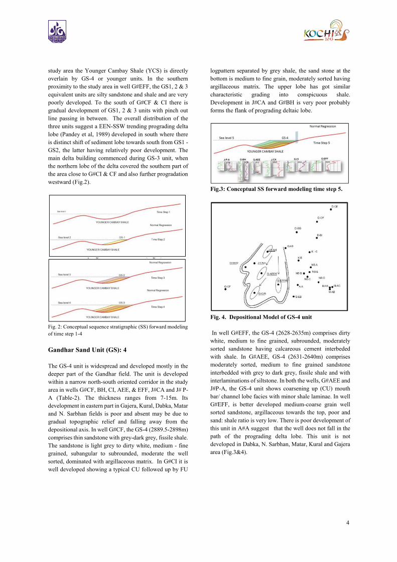
Fig.3: Conceptual SS forward modeling time step 5.
Fig. 4. Depositional Model of GS-4 unit
In well G#EFF, the GS-4 (2628-2635m) comprises dirty
white, medium to fine grained, subrounded, moderately
sorted sandstone having calcareous cement interbeded
with shale. In G#AEE, GS-4 (2631-2640m) comprises
moderately sorted, medium to fine grained sandstone
interbedded with grey to dark grey, fissile shale and with
interlaminations of siltstone. In both the wells, G#AEE and
J#P-A, the GS-4 unit shows coarsening up (CU) mouth
bar/ channel lobe facies with minor shale laminae. In well
G#EFF, is better developed medium-coarse grain well
sorted sandstone, argillaceous towards the top, poor and
sand: shale ratio is very low. There is poor development of
this unit in A#A suggest that the well does not fall in the
path of the prograding delta lobe. This unit is not
developed in Dabka, N. Sarbhan, Matar, Kural and Gajera
area (Fig.3&4).
5
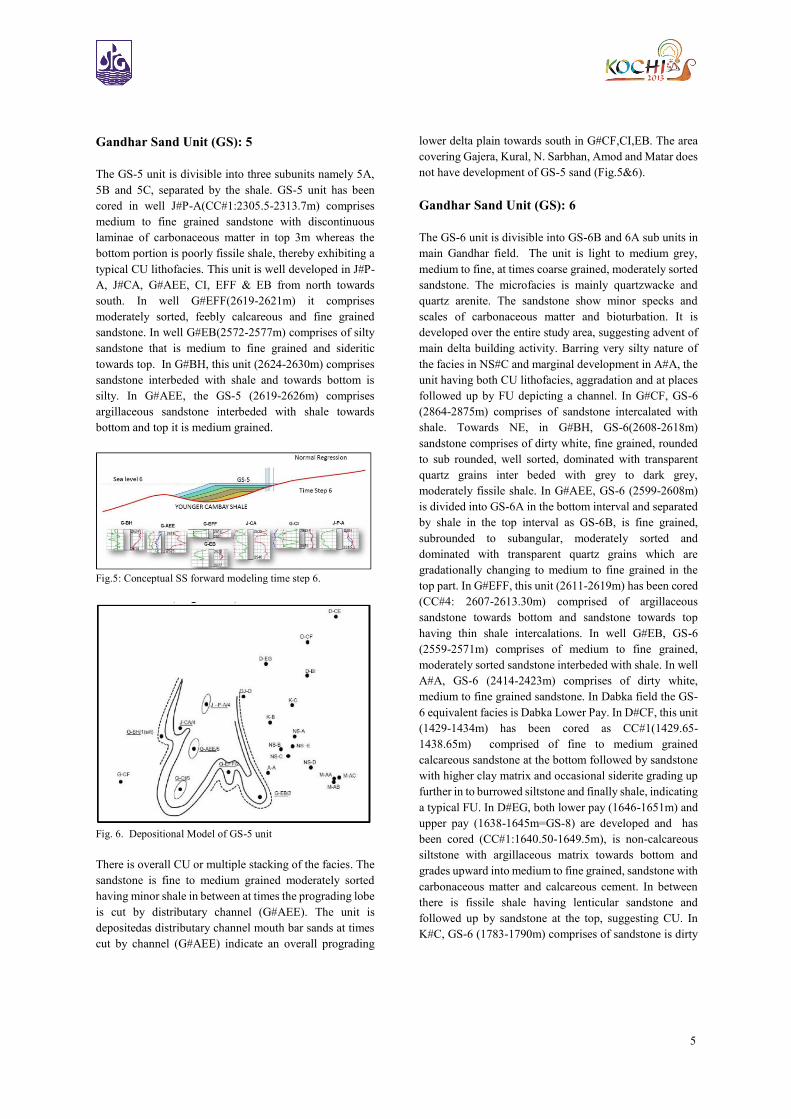
Gandhar Sand Unit (GS): 5
The GS-5 unit is divisible into three subunits namely 5A,
5B and 5C, separated by the shale. GS-5 unit has been
cored in well J#P-A(CC#1:2305.5-2313.7m) comprises
medium to fine grained sandstone with discontinuous
laminae of carbonaceous matter in top 3m whereas the
bottom portion is poorly fissile shale, thereby exhibiting a
typical CU lithofacies. This unit is well developed in J#P-
A, J#CA, G#AEE, CI, EFF & EB from north towards
south. In well G#EFF(2619-2621m) it comprises
moderately sorted, feebly calcareous and fine grained
sandstone. In well G#EB(2572-2577m) comprises of silty
sandstone that is medium to fine grained and sideritic
towards top. In G#BH, this unit (2624-2630m) comprises
sandstone interbeded with shale and towards bottom is
silty. In G#AEE, the GS-5 (2619-2626m) comprises
argillaceous sandstone interbeded with shale towards
bottom and top it is medium grained.
Fig.5: Conceptual SS forward modeling time step 6.
Fig. 6. Depositional Model of GS-5 unit
There is overall CU or multiple stacking of the facies. The
sandstone is fine to medium grained moderately sorted
having minor shale in between at times the prograding lobe
is cut by distributary channel (G#AEE). The unit is
depositedas distributary channel mouth bar sands at times
cut by channel (G#AEE) indicate an overall prograding
lower delta plain towards south in G#CF,CI,EB. The area
covering Gajera, Kural, N. Sarbhan, Amod and Matar does
not have development of GS-5 sand (Fig.5&6).
Gandhar Sand Unit (GS): 6
The GS-6 unit is divisible into GS-6B and 6A sub units in
main Gandhar field. The unit is light to medium grey,
medium to fine, at times coarse grained, moderately sorted
sandstone. The microfacies is mainly quartzwacke and
quartz arenite. The sandstone show minor specks and
scales of carbonaceous matter and bioturbation. It is
developed over the entire study area, suggesting advent of
main delta building activity. Barring very silty nature of
the facies in NS#C and marginal development in A#A, the
unit having both CU lithofacies, aggradation and at places
followed up by FU depicting a channel. In G#CF, GS-6
(2864-2875m) comprises of sandstone intercalated with
shale. Towards NE, in G#BH, GS-6(2608-2618m)
sandstone comprises of dirty white, fine grained, rounded
to sub rounded, well sorted, dominated with transparent
quartz grains inter beded with grey to dark grey,
moderately fissile shale. In G#AEE, GS-6 (2599-2608m)
is divided into GS-6A in the bottom interval and separated
by shale in the top interval as GS-6B, is fine grained,
subrounded to subangular, moderately sorted and
dominated with transparent quartz grains which are
gradationally changing to medium to fine grained in the
top part. In G#EFF, this unit (2611-2619m) has been cored
(CC#4: 2607-2613.30m) comprised of argillaceous
sandstone towards bottom and sandstone towards top
having thin shale intercalations. In well G#EB, GS-6
(2559-2571m) comprises of medium to fine grained,
moderately sorted sandstone interbeded with shale. In well
A#A, GS-6 (2414-2423m) comprises of dirty white,
medium to fine grained sandstone. In Dabka field the GS-
6 equivalent facies is Dabka Lower Pay. In D#CF, this unit
(1429-1434m) has been cored as CC#1(1429.65-
1438.65m) comprised of fine to medium grained
calcareous sandstone at the bottom followed by sandstone
with higher clay matrix and occasional siderite grading up
further in to burrowed siltstone and finally shale, indicating
a typical FU. In D#EG, both lower pay (1646-1651m) and
upper pay (1638-1645m=GS-8) are developed and has
been cored (CC#1:1640.50-1649.5m), is non-calcareous
siltstone with argillaceous matrix towards bottom and
grades upward into medium to fine grained, sandstone with
carbonaceous matter and calcareous cement. In between
there is fissile shale having lenticular sandstone and
followed up by sandstone at the top, suggesting CU. In
K#C, GS-6 (1783-1790m) comprises of sandstone is dirty
6
white, fine to coarse grained, subrounded to subangular,
moderate to poorly sorted, rarely calcareous. In well
NS#D, GS-6 (1997-2000m) comprises of medium to fine
grained sandstone is moderately sorted, having
argillaceous matrix. In M#AA, GS-6 (1778-1785m),
M#AB, GS-6 (1793-1797m) and M#AC, GS-6 (1770-
1779m) comprises of sandstone of dirty white, yellowish,
fine to coarse grained, sub rounded to sub angular,
moderate to poorly sorted, interbeded by grey to dark grey,
poorly fissile, non-calcareous shale with disseminated
pyrite.
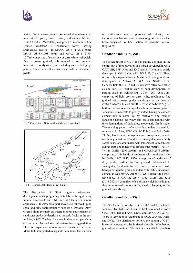
Fig.7: Conceptual SS forward modeling of time step 7
Fig. 8. Depositional Model of GS-6 unit
The distribution of GS-6 suggests widespread
development of the prograding delta lobe with slight swing
in input direction towards NE. In NS#C, the facies is more
argillaceous. In A#A basal part shows CU followed up by
shale and silty shale probably suggest a crevasse splay.
Overall along the main axis there is better development of
sandstone gradually deteriorates towards flanks in the east
in A#A, NS#C. The log characters in the central part show
CU as mouth bar and stacked pattern due to aggradation.
There is a significant development of sandstone in east in
Matar field interpreted as separate delta lobe. The increase
in argillaceous matrix, presence of siderite, rare
carbonaceous laminae and burrows suggest that area had
been subjected to tidal action at periodic interval
(Fig.7&8).
Gandhar Sand Unit (GS): 7
The development of GS-7 unit is mainly confined in the
central part of the study area and is best developed in wells
G#CI, EB, EFF, A#A and K#C and B. The unit is poorly
developed in G#BH, CA, AEE, NS A, B, C and E . There
is probably a separate lobe in Matar field having moderate
development in M#AA, AB &AC and NS#D. In the
Gandhar field the GS-7 and 8 units have often been taken
as one unit (GS-7+8) in view of poor development of
parting shale. In well G#EFF, CC#4 ((2607-2613.30m)
comprises of light grey to dirty white, medium to fine
grained with coarse grains sandstone in the interval
(2608.65-2607). In well G#EB in CC#2 (2544-2552m) the
bottom portion is made up of medium to coarse grained
sandstone is moderate to poorly sorted, having calcareous
cement and followed up by relatively fine grained
sandstone having the wavy and cross laminations with
thick laminations of dark grey, moderately fissile shale.
The stacking pattern reflects an incomplete channel fill
sequence. In A#A, GS-6 (2414-2423m) and 7+8 (2404-
2413m) has been taken together and comprises coarse to
medium grained, subrounded to subangular, moderately
sorted sandstone dominated with transparent to translucent
quartz grains bounded with argillaceous matrix. The GS-
7+8 in G#BH (2593-2606m) and G#AEE(2575-2594m)
comprises of thin bands of sandstone with dominant shale.
In NS#D, GS-7 (1992-1995m) comprises of sandstone of
dirty white, medium to fine grained, subrounded to
subangular, moderate to well sorted, dominated with
transparent quartz grains bounded with feebly calcareous
cement. In well M#AA, AB & AC, GS-7 appears to be well
developed. In K#C the GS-7 (1762-1780m) and K#B
(2018-2021m) comprises of sandstone which is medium to
fine grain towards bottom and gradually changing to fine
grained towards top.
Gandhar Sand Unit (GS): 8
The GS-8 unit is divisible in to GS-8A and 8B subunits
separated by shale. GS-8 sand is best developed in wells
G#CI, EFF, EB and A#A, NS#D and M#AA, AB & AC.
There is very poor development in J#CA, G#AEE, D#EF,
and GJ#D. The distribution follows the pattern of GS-7,
however a separate lobe initiated towards J#CA having
gradual deterioration of facies towards G#BH. Numbers
7
of cores of the unit have been taken in M#AA, AB, AC,
G#EB and NS#B. In well M#AA, the CC#6(1772-
1778.5m) in the basal part comprises alternation of fine to
medium grained sandstone showing bioturbation and shale
which is often sideritic and carbonaceous. The CC#5
(1759-1763.5m) is argillaceous sandstone and silty shale.
In well M#AB the CC-1(1765-1774m) is medium to fine
grained sandstone (quartzwacke) having argillaceous
matrix. In well M#AC the CC#2(1758-1761.5m) is
calcareous sandstone is occasionally bioturbated and
comprises fine, transparent to translucent, subangular to
subrounded, moderately sorted quartz bound by
argillaceous matrix. In well NS#B, CC#2 (2010-2018.9)
has been cut in GS-8 (2002-2015m) comprises medium to
fine grained bioturbated sandstone interbeded with shale.
In D#EG, the core CC#1(1640.50-1649.5m) covers both
Dabka upper pay (1638-1645m=GS-8) and Dabka lower
pay (1646-1651m=GS-6) comprises grey to brownish
grey, non-calcareous, silty sandstone having argillaceous
matrix and shale having carbonaceous matter with top 5cm
having lenticular bodies of coarse grained feebly
calcareous sandstone. In wells G#3I, EFF, EB & A#A, the
GS-7+8 are sandstone exhibits multiple stacking.
It appears that the overall spread of the prograding delta
lobe has been reduced from GS-6.The bay mapped close to
NS#B in GS-6 has become prominent, while GS-7 unit is
poorly developed in NS#A, B, C & E and makes prominent
lobe in Matar area. The characteristic CU of lithofacies,
log signature and moderate sorting in wells G#EI, EFF,EB
and A#A suggest both aggradation and progradation of the
delta mouth bar sands in the close proximity. The relative
dominance of argillaceous sandstone facies and FU in
wells K#B & C suggest presence of distributary channels
in lower delta plain in the area.
The lithofacies association, distribution of facies and
overall log pattern indicate a more or less similar
depositional pattern as considered in GS-7. The bay
developed in N.Sarbhan area remained prominent and
there is better development of reservoir facies in Matar
area with likely progradation to further southwest. The
distributary channel persists in K#B &C. The overall trend
remains NE-SW with progradation of a few lobes due
south (Fig. 9&10).
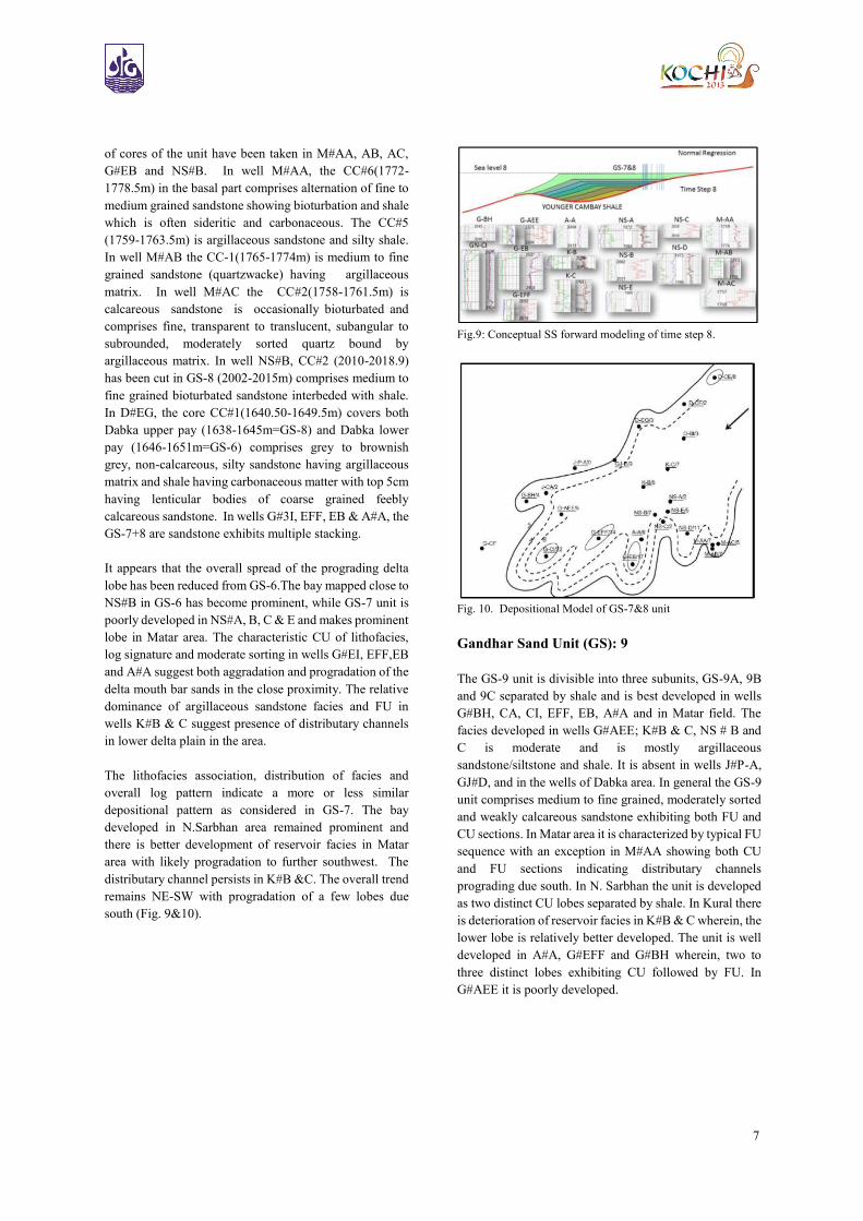
Fig.9: Conceptual SS forward modeling of time step 8.
Fig. 10. Depositional Model of GS-7&8 unit
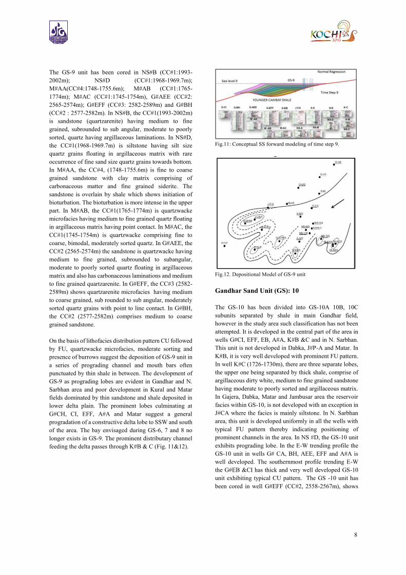
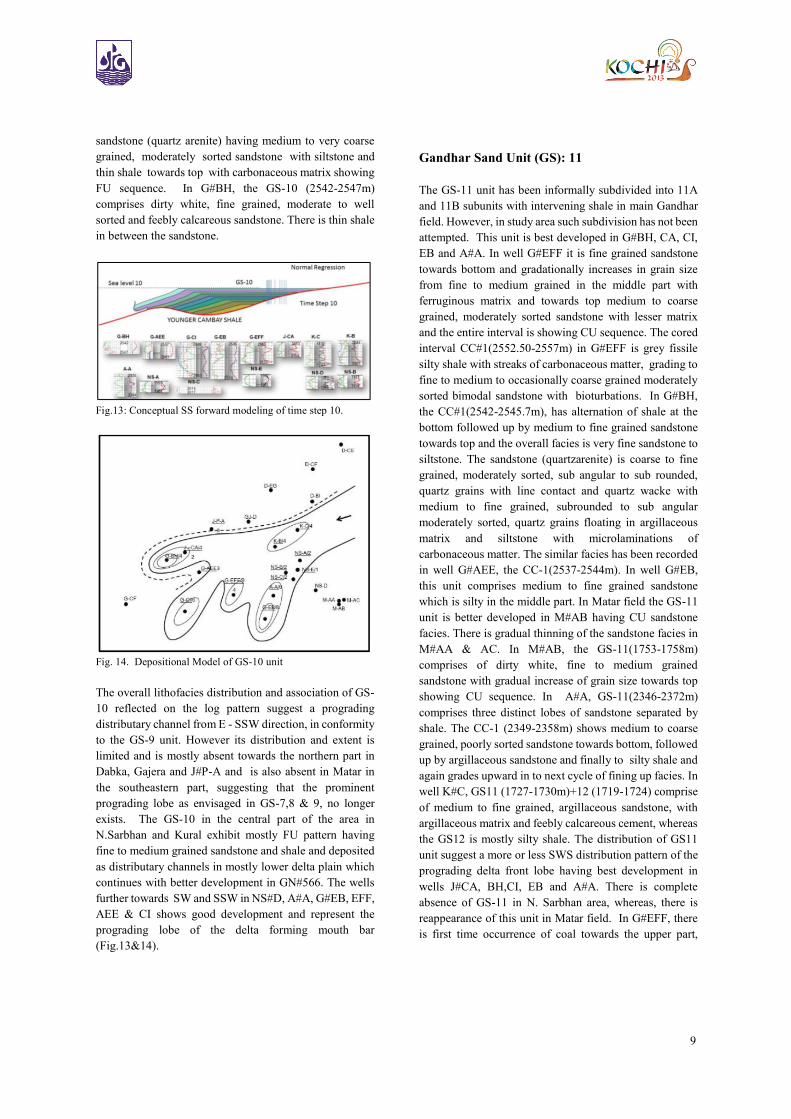
Gandhar Sand Unit (GS): 9
The GS-9 unit is divisible into three subunits, GS-9A, 9B
and 9C separated by shale and is best developed in wells
G#BH, CA, CI, EFF, EB, A#A and in Matar field. The
facies developed in wells G#AEE; K#B & C, NS # B and
C is moderate and is mostly argillaceous
sandstone/siltstone and shale. It is absent in wells J#P-A,
GJ#D, and in the wells of Dabka area. In general the GS-9
unit comprises medium to fine grained, moderately sorted
and weakly calcareous sandstone exhibiting both FU and
CU sections. In Matar area it is characterized by typical FU
sequence with an exception in M#AA showing both CU
and FU sections indicating distributary channels
prograding due south. In N. Sarbhan the unit is developed
as two distinct CU lobes separated by shale. In Kural there
is deterioration of reservoir facies in K#B & C wherein, the
lower lobe is relatively better developed. The unit is well
developed in A#A, G#EFF and G#BH wherein, two to
three distinct lobes exhibiting CU followed by FU. In
G#AEE it is poorly developed.
8
The GS-9 unit has been cored in NS#B (CC#1:1993-
2002m); NS#D (CC#1:1968-1969.7m);
M#AA(CC#4:1748-1755.6m); M#AB (CC#1:1765-
1774m); M#AC (CC#1:1745-1754m), G#AEE (CC#2:
2565-2574m); G#EFF (CC#3: 2582-2589m) and G#BH
(CC#2 : 2577-2582m). In NS#B, the CC#1(1993-2002m)
is sandstone (quartzarenite) having medium to fine
grained, subrounded to sub angular, moderate to poorly
sorted, quartz having argillaceous laminations. In NS#D,
the CC#1(1968-1969.7m) is siltstone having silt size
quartz grains floating in argillaceous matrix with rare
occurrence of fine sand size quartz grains towards bottom.
In M#AA, the CC#4, (1748-1755.6m) is fine to coarse
grained sandstone with clay matrix comprising of
carbonaceous matter and fine grained siderite. The
sandstone is overlain by shale which shows initiation of
bioturbation. The bioturbation is more intense in the upper
part. In M#AB, the CC#1(1765-1774m) is quartzwacke
microfacies having medium to fine grained quartz floating
in argillaceous matrix having point contact. In M#AC, the
CC#1(1745-1754m) is quartzwacke comprising fine to
coarse, bimodal, moderately sorted quartz. In G#AEE, the
CC#2 (2565-2574m) the sandstone is quartzwacke having
medium to fine grained, subrounded to subangular,
moderate to poorly sorted quartz floating in argillaceous
matrix and also has carbonaceous laminations and medium
to fine grained quartzarenite. In G#EFF, the CC#3 (2582-
2589m) shows quartzarenite microfacies having medium
to coarse grained, sub rounded to sub angular, moderately
sorted quartz grains with point to line contact. In G#BH,
the CC#2 (2577-2582m) comprises medium to coarse
grained sandstone.
On the basis of lithofacies distribution pattern CU followed
by FU, quartzwacke microfacies, moderate sorting and
presence of burrows suggest the deposition of GS-9 unit in
a series of prograding channel and mouth bars often
punctuated by thin shale in between. The development of
GS-9 as prograding lobes are evident in Gandhar and N.
Sarbhan area and poor development in Kural and Matar
fields dominated by thin sandstone and shale deposited in
lower delta plain. The prominent lobes culminating at
G#CH, CI, EFF, A#A and Matar suggest a general
progradation of a constructive delta lobe to SSW and south
of the area. The bay envisaged during GS-6, 7 and 8 no
longer exists in GS-9. The prominent distributary channel
feeding the delta passes through K#B & C (Fig. 11&12).
Fig.11: Conceptual SS forward modeling of time step 9.
Fig.12. Depositional Model of GS-9 unit
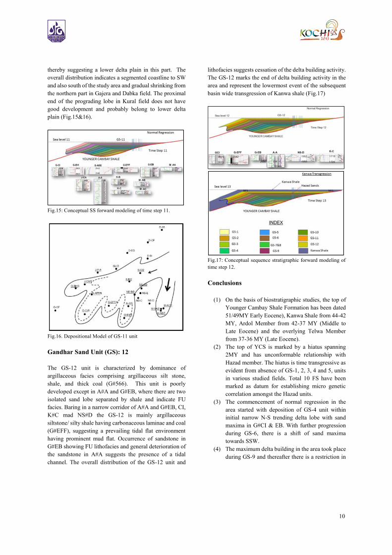
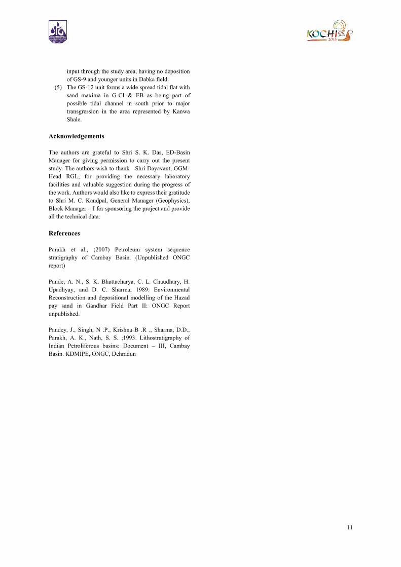
Gandhar Sand Unit (GS): 10
The GS-10 has been divided into GS-10A 10B, 10C
subunits separated by shale in main Gandhar field,
however in the study area such classification has not been
attempted. It is developed in the central part of the area in
wells G#CI, EFF, EB, A#A, K#B &C and in N. Sarbhan.
This unit is not developed in Dabka, J#P-A and Matar. In
K#B, it is very well developed with prominent FU pattern.
In well K#C (1726-1730m), there are three separate lobes,
the upper one being separated by thick shale, comprise of
argillaceous dirty white, medium to fine grained sandstone
having moderate to poorly sorted and argillaceous matrix.
In Gajera, Dabka, Matar and Jambusar area the reservoir
facies within GS-10, is not developed with an exception in
J#CA where the facies is mainly siltstone. In N. Sarbhan
area, this unit is developed uniformly in all the wells with
typical FU pattern thereby indicating positioning of
prominent channels in the area. In NS #D, the GS-10 unit
exhibits prograding lobe. In the E-W trending profile the
GS-10 unit in wells G# CA, BH, AEE, EFF and A#A is
well developed. The southernmost profile trending E-W
the G#EB &CI has thick and very well developed GS-10
unit exhibiting typical CU pattern. The GS -10 unit has
been cored in well G#EFF (CC#2, 2558-2567m), shows
9
sandstone (quartz arenite) having medium to very coarse
grained, moderately sorted sandstone with siltstone and
thin shale towards top with carbonaceous matrix showing
FU sequence. In G#BH, the GS-10 (2542-2547m)
comprises dirty white, fine grained, moderate to well
sorted and feebly calcareous sandstone. There is thin shale
in between the sandstone.
Fig.13: Conceptual SS forward modeling of time step 10.
Fig. 14. Depositional Model of GS-10 unit
The overall lithofacies distribution and association of GS-
10 reflected on the log pattern suggest a prograding
distributary channel from E - SSW direction, in conformity
to the GS-9 unit. However its distribution and extent is
limited and is mostly absent towards the northern part in
Dabka, Gajera and J#P-A and is also absent in Matar in
the southeastern part, suggesting that the prominent
prograding lobe as envisaged in GS-7,8 & 9, no longer
exists. The GS-10 in the central part of the area in
N.Sarbhan and Kural exhibit mostly FU pattern having
fine to medium grained sandstone and shale and deposited
as distributary channels in mostly lower delta plain which
continues with better development in GN#566. The wells
further towards SW and SSW in NS#D, A#A, G#EB, EFF,
AEE & CI shows good development and represent the
prograding lobe of the delta forming mouth bar
(Fig.13&14).
Gandhar Sand Unit (GS): 11
The GS-11 unit has been informally subdivided into 11A
and 11B subunits with intervening shale in main Gandhar
field. However, in study area such subdivision has not been
attempted. This unit is best developed in G#BH, CA, CI,
EB and A#A. In well G#EFF it is fine grained sandstone
towards bottom and gradationally increases in grain size
from fine to medium grained in the middle part with
ferruginous matrix and towards top medium to coarse
grained, moderately sorted sandstone with lesser matrix
and the entire interval is showing CU sequence. The cored
interval CC#1(2552.50-2557m) in G#EFF is grey fissile
silty shale with streaks of carbonaceous matter, grading to
fine to medium to occasionally coarse grained moderately
sorted bimodal sandstone with bioturbations. In G#BH,
the CC#1(2542-2545.7m), has alternation of shale at the
bottom followed up by medium to fine grained sandstone
towards top and the overall facies is very fine sandstone to
siltstone. The sandstone (quartzarenite) is coarse to fine
grained, moderately sorted, sub angular to sub rounded,
quartz grains with line contact and quartz wacke with
medium to fine grained, subrounded to sub angular
moderately sorted, quartz grains floating in argillaceous
matrix and siltstone with microlaminations of
carbonaceous matter. The similar facies has been recorded
in well G#AEE, the CC-1(2537-2544m). In well G#EB,
this unit comprises medium to fine grained sandstone
which is silty in the middle part. In Matar field the GS-11
unit is better developed in M#AB having CU sandstone
facies. There is gradual thinning of the sandstone facies in
M#AA & AC. In M#AB, the GS-11(1753-1758m)
comprises of dirty white, fine to medium grained
sandstone with gradual increase of grain size towards top
showing CU sequence. In A#A, GS-11(2346-2372m)
comprises three distinct lobes of sandstone separated by
shale. The CC-1 (2349-2358m) shows medium to coarse
grained, poorly sorted sandstone towards bottom, followed
up by argillaceous sandstone and finally to silty shale and
again grades upward in to next cycle of fining up facies. In
well K#C, GS11 (1727-1730m)+12 (1719-1724) comprise
of medium to fine grained, argillaceous sandstone, with
argillaceous matrix and feebly calcareous cement, whereas
the GS12 is mostly silty shale. The distribution of GS11
unit suggest a more or less SWS distribution pattern of the
prograding delta front lobe having best development in
wells J#CA, BH,CI, EB and A#A. There is complete
absence of GS-11 in N. Sarbhan area, whereas, there is
reappearance of this unit in Matar field. In G#EFF, there
is first time occurrence of coal towards the upper part,
10
thereby suggesting a lower delta plain in this part. The
overall distribution indicates a segmented coastline to SW
and also south of the study area and gradual shrinking from
the northern part in Gajera and Dabka field. The proximal
end of the prograding lobe in Kural field does not have
good development and probably belong to lower delta
plain (Fig.15&16).
Fig.15: Conceptual SS forward modeling of time step 11.
Fig.16. Depositional Model of GS-11 unit
Gandhar Sand Unit (GS): 12
The GS-12 unit is characterized by dominance of
argillaceous facies comprising argillaceous silt stone,
shale, and thick coal (G#566). This unit is poorly
developed except in A#A and G#EB, where there are two
isolated sand lobe separated by shale and indicate FU
facies. Baring in a narrow corridor of A#A and G#EB, CI,
K#C mad NS#D the GS-12 is mainly argillaceous
siltstone/ silty shale having carbonaceous laminae and coal
(G#EFF), suggesting a prevailing tidal flat environment
having prominent mud flat. Occurrence of sandstone in
G#EB showing FU lithofacies and general deterioration of
the sandstone in A#A suggests the presence of a tidal
channel. The overall distribution of the GS-12 unit and
lithofacies suggests cessation of the delta building activity.
The GS-12 marks the end of delta building activity in the
area and represent the lowermost event of the subsequent
basin wide transgression of Kanwa shale (Fig.17)
Fig.17: Conceptual sequence stratigraphic forward modeling of
time step 12.
Conclusions
(1) On the basis of biostratigraphic studies, the top of
Younger Cambay Shale Formation has been dated
51/49MY Early Eocene), Kanwa Shale from 44-42
MY, Ardol Member from 42-37 MY (Middle to
Late Eocene) and the overlying Telwa Member
from 37-36 MY (Late Eocene).
(2) The top of YCS is marked by a hiatus spanning
2MY and has unconformable relationship with
Hazad member. The hiatus is time transgressive as
evident from absence of GS-1, 2, 3, 4 and 5, units
in various studied fields. Total 10 FS have been
marked as datum for establishing micro genetic
correlation amongst the Hazad units.
(3) The commencement of normal regression in the
area started with deposition of GS-4 unit within
initial narrow N-S trending delta lobe with sand
maxima in G#CI & EB. With further progression
during GS-6, there is a shift of sand maxima
towards SSW.
(4) The maximum delta building in the area took place
during GS-9 and thereafter there is a restriction in
11
input through the study area, having no deposition
of GS-9 and younger units in Dabka field.
(5) The GS-12 unit forms a wide spread tidal flat with
sand maxima in G-CI & EB as being part of
possible tidal channel in south prior to major
transgression in the area represented by Kanwa
Shale.
Acknowledgements
The authors are grateful to Shri S. K. Das, ED-Basin
Manager for giving permission to carry out the present
study. The authors wish to thank Shri Dayavant, GGM-
Head RGL, for providing the necessary laboratory
facilities and valuable suggestion during the progress of
the work. Authors would also like to express their gratitude
to Shri M. C. Kandpal, General Manager (Geophysics),
Block Manager – I for sponsoring the project and provide
all the technical data.
References
Parakh et al., (2007) Petroleum system sequence
stratigraphy of Cambay Basin. (Unpublished ONGC
report)
Pande, A. N., S. K. Bhattacharya, C. L. Chaudhary, H.
Upadhyay, and D. C. Sharma, 1989: Environmental
Reconstruction and depositional modelling of the Hazad
pay sand in Gandhar Field Part II: ONGC Report
unpublished.
Pandey, J., Singh, N .P., Krishna B .R ., Sharma, D.D.,
Parakh, A. K., Nath, S. S. ;1993. Lithostratigraphy of
Indian Petroliferous basins: Document – III, Cambay
Basin. KDMIPE, ONGC, Dehradun