Embed Size (px)
Citation preview

Missouri University of Science and Technology Missouri University of Science and Technology
Scholars' Mine Scholars' Mine
International Conference on Case Histories in Geotechnical Engineering
(1988) - Second International Conference on Case Histories in Geotechnical Engineering
02 Jun 1988, 10:30 am - 3:00 pm
Lithotectonic Landslides and Hazards in Parts of Garhwal-Lithotectonic Landslides and Hazards in Parts of Garhwal-
Kumaon Himalayas Kumaon Himalayas
R. S. Mithal University of Roorkee, Roorkee, India
Follow this and additional works at: https://scholarsmine.mst.edu/icchge
Part of the Geotechnical Engineering Commons
Recommended Citation Recommended Citation Mithal, R. S., "Lithotectonic Landslides and Hazards in Parts of Garhwal-Kumaon Himalayas" (1988). International Conference on Case Histories in Geotechnical Engineering. 21. https://scholarsmine.mst.edu/icchge/2icchge/2icchge-session2/21
This work is licensed under a Creative Commons Attribution-Noncommercial-No Derivative Works 4.0 License.
This Article - Conference proceedings is brought to you for free and open access by Scholars' Mine. It has been accepted for inclusion in International Conference on Case Histories in Geotechnical Engineering by an authorized administrator of Scholars' Mine. This work is protected by U. S. Copyright Law. Unauthorized use including reproduction for redistribution requires the permission of the copyright holder. For more information, please contact [email protected].

Proceedings: Second International Conference on Case Histories in Geotechnical Engineering, June 1-5, 1988, St. Louis, Mo., Paper No. 2.55
Lithotectonic Landslides and Hazards in Parts of Garhwai-Kumaon Himalayas R.S. Mithal Emeritus Professor, Earth Sciences, University of Roorkee, Roorkee, India
SYNOPSIS
Landslides produce an awsome picture of the hill sides with steep scarred, hollowed and gullied geomorphic features devoid of vegetation particularly between the major thrust zones. A look on the tectono-stratigraphic map of the region with marked major tectonic features like the Main Central Thrust (MCT), North Almora Thrust (NAT) and South Almora Thrust (SAT) indicates that the region is highly prone to landslides and is affected by repeated tectonic and orogenic processes. These factors with the nature of the rocks, climate and the heavy monsoon rains are responsible for sculpturing the region. The mountain features and the valley slopes thus indicate the influence of the activities and the dynamic forces at a particular locality and time. Many times developmental activities have also contributed towards the degradation of the environs due to disturbance of the already stabilized slopes and the angles of repose e.g. along the Rishikesh - Badrinath Road, where a new alignment has been given, sometimes overlapping the old pilgrim route.
IN'TRODUCTION
In India, the awareness of the effects of landslides is hardly two decades old. Though the phenomenon has been going on, the importance of their occurrance and the resultant losses had been recognised only after the Belakuchi disaster in 1970 due to flash floods. As a result the whole Alaknanda valley got flooded, caused innumerable landslides in its course, dammed the river, formed new terraces in the wider valleys, breached the existing lakes and reservoirs, pulled down lines of communications and transmission, washed out roads and bye passed the existing bridges, wiped out a number of hamlets and habitations and road side shops etc. killed at least 17 people and loss of 23 vehicles, silted up the existing canals, changed the river courses and bye passed the bridges, washed off miles of road sections thus disrupting the life and livelihood of the people.
In fact, even this was being forgotten, when another similar catastrophe occurred close to Ganganani in July 1978 on the Uttarkashi Gangotri road another pilgrim route. Due to this calamity another 8 vehicles got lost and a number of pilgrims died with more than 2km road on the right bank washed away and a girder bridge byepassed. Later, a new alignment on the left bank had to be laid and cut through almost vertical precipices. This is still not stabilized and a team of workers with bouldozers are posted to keep the passage open.
Landslides are ambiguous processes of catastrophic events of which the most important and direct effects on mankind are loss of life and property, damage to natural resources, disturbance in the ecosystem and environment. Recently a number of papers have appeared
311
on the Himalayan slides but not much has been said on their relationship to the geological and tectonic set up and the hazards caused (in the region), particularly with a view to civil works. Barring a few, the accounts portray only the events, though most of them, as major disturbances have disrupted the life of the local people and caused hazards to the developmental activities in the region. Majority of these slides chiefly lie in a belt nearly 30 to SOkm in width and extend from a general level of 150m to nearly 2,750m.
The slope failures are largely due to rock falls, debris flow, slumps, creep flow, earth flows and certain complex mass failures including the rock avalanche types. Many a time massive and temporary blockages occur due to sudden inflow of waste debris forming small reservoirs, lakes or lakelets in the courses of rivers. However, the latter and sudden bursts or breaches of these lakes are often observed to have caused unimaginable havocs and catastrophies in the lower reaches of the catchment area. Of these, floods of years 1880, 1924, 1971, 1978 coupled with large scale slides are still memorable. The creation of Gohna Tal in 1893 and its later obliteration in 1971 due to high monsoon rains or flash floods is one of the most important events in the landslide history of the region.
Along the Rishikesh-Badrinath road and many other new excavations and cuts, landslides are more common now and numberous as old angles of repose have been disturbed. In brief, the horrendous topography with inhospitable terrain full of complex geomorphic features, all make the region most hazardous to the people, the locality as well as for any developmental activities.
Second International Conference on Case Histories in Geotechnical Engineering Missouri University of Science and Technology http://ICCHGE1984-2013.mst.edu
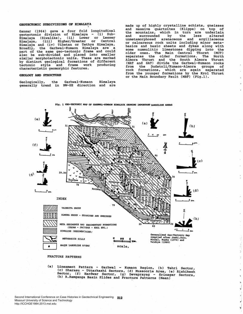
GBOTBC'roto:C SUBDIVISIONS OP BIMALA'!A
Gansar (1964) gave a four fold longitudinal geotectonic division of Himalaya (i) SubHimalaya ( Siwaliks) , ( ii l Lower or Lesser Himalaya, (iii) Higher/Greater or Central Himalaya and (iv) Tibetan or Tethys Himalaya. Broadly, the Garhwal-Kumao~ Himalaya are a part of the same geo-tecton1c frame and could also be sub-divided and placed into smaller similar morphotectonic units. These are marked by distinct geological formations of different tectonic· style and frame work producing characteristic geomorphic features.
GBOLOGY AND S'.rROCTUBB
Geologically, the generally trend in
(e)! L 'Aoc
~
II t
(f) ~ t...._._._! a ...
H
Garhwal-Kumaon NW-SE direction
.., J I..<J)
29.30 >f
~ • • ....
INDEX
VAIKRI'l'A GROOP
Himalaya and are
-IJifl~~ £11 ALIIORA GltOOP - GRANI'l'ES A11D GNEISSES
~~ I I I~ I • I
ME'l'A SEDIMEII'l'S All~ SEDIIIEN'l'ARY l'OIIMA'I'IONS ('l'ZJAM - JAt:ltSAR - ICROL !'l'C.)
SIWAI.III:S ( S!DIIIE!r.ltll!S 1
MB'l'ABASICS SILLS • I MAJpR LANDSLIDE A.":"I!AS
FRACTURE PATTERNS
made up of highly crystalline.schists, gneisses and massive quartzites (Kl1ppe) on top of the mountains, which in turn are underlain and surrounded by the less altered unmetamorphosed arenaceo~s and argillaceous or calcareous rock units including minor metabasics and basic sheets and dykes along with some nummulitic limestones dipping into the older ones. The Main Central Thurst (MCT) separates the older formations. The North Almora Thrust and the South Almora Thrust (NAT and SAT) divide the Garhwal-Kumaon rocks from the Dudatoli/Kumaon-Almora groups of rock formations, which are again separated from the younger formations by the Krol Thrust or the Main .Boundary Fault (MBF) (Fig.!).
.... J 1. t K•·
scale,
(a)~
f ........ _....._ ..... ....,.
30
80
~-·---...... ·JC<o.
Generali•ed Geo-'l'ectonic Map COftpiled after Joahi,Jain, Hithlll, Rupke (1974) and Valdiya ( 1980)
(a) Lineament Pattern - Garhwal - Kumaon Region, (b) Tehri Sector, (c) Dharasu - Uttarkashi Sectors, (d) Mussoorie Area, (e) Rishikesh Sector, (f) Hardwar Sector, ( q) Devaprayag - Srinagar Sectors, (h) R.Ramganga Basin Slides and Fracture Patterns (Mean)
312
., !
lo'
.; ;
tl i .,!
Second International Conference on Case Histories in Geotechnical Engineering Missouri University of Science and Technology http://ICCHGE1984-2013.mst.edu

In addition, numerous faults and minor thrusts trending in NW-SE and N-S directions also dissect the region alongwith many sets of joints, fractures, cleavages and lineaments and other discontinuities in almost all directions of azymuth. Of these, weak structures in NE-SW, NNE-SSW and N-S (in order) directions are prominant and fully responsible for the fragile nature of the rocks involved. Thus the rock units are highly vulnerable to erosion and even to other minor disturbances prevalent in this mountaineous terrain.
Structurally, the rocks are more complex and complicated due . to several tectonic episodes. In addition to the major thrusts, nappe sheets and klippes etc. at least three to four phases of tectonic and neo-tectonic events are recognisible and established in the field. The neotectonic activity appears to be spasmodic (Mithal 1968) as evidenced by the recent level disturbances and the most recent episodes in the river terraces along the valleys of the major rivers and the frequent seismic tremors felt in the area.
From the location of landslides or the potential zones of mass movements, the GarhwalKumaon groups of rocks are more susceptible to landslide activity (Table l) and the major landslide zones are mainly confined to these formations.
LITHOLOGY AND TEC'l'ONIC UNITS
The sub-himalayan zone comprises of Neogene mollasse sediments (Siwaliks) and the lower Tertiary Subathu formations, north of which lie the MBF or the Krol Thrust and in the south these formations are overlain by the thick Indo-Gangetic alluvium. Structurally this zone is affected by NW-SE running asymmetrical folds bounded by large scale high angled reverse faults also cutting the axes. In the lesser Himalaya, unfossiliferrous Pre-eambrian to Tertiary sediments of low grade metamorphism are predominant and are delimited by the MBF-Krol Thrust (in the south) and the Main Central Thrust in the north. These are highly folded and deformed due to multiple folds, faults and thrusts many times in association of meta-basic sills or sheets. Thus they produce a highly complex structure with at least three subtectonic divisions: (i) Autochonous Pre-cambrian low grade sediments in the inner or the northern parts, ( ii ) the middle Krol Nappe (including the Nagthat quarzites, Chandpur Phyllites, Blaini and Infra Krol formations, Krol limestone and Tal and Subathu formations), (iii) Rocks of the Almora or Garhwal Nappe of low to high grade metamorphics. These litho-tectonic units are highly complex since these also are affected by many thrusts and faults with associated imbricate structures and shears in both transverse and longitudinal directions. Many of these features also appear to be still active. Many other minor features like joints, cleavages and fractures also affect these rock units. As such the ·massive competent rocks are crumpled and crushed while the non-competent types are foliated and have developed fissility. Likewise, the metabasics in thinner bodies are also foliated and fissile, while the thicker massive sills or dykes behave
313
both as competent and incompetent bodies in the area, e.g. at Kaliasaur, Dunda, Nakuri etc. in Garhwal and Ramgarh etc. in Kumaon.
TABLE I. Tectonic Succession and its Correlation in the Garhwal-Kumaon Himalaya
FORMATION LITHOLOGY
Amri Formation
Phyllite, quartz-mica schist, mica schist, garnetiferrous mica schist, granite-gneiss
Thrust
Raitpur Formation
Muddy boulder bed, shale, limestone
Subathu Group
Tal Group
Krol Group
Jaunsar Group
NAT or Garhwal Thrust
Shale, sandstone, fossiliferrous limestone
Unconformity
Upper Tal
Middle Tal
Lower Tal
Krol formation
Infra Krol formation
Blaini formation
Oolitic limestone, sandstone
Ortho-quartzite, shale, limestone, siltstone
Shale, siltstone, phosphorite
Massive limestone, dolomite, shale and red shale
Shale, slate, limestone
Muddy boulder bed, limestone, sandstone, shale
Unconformity
Nagthet for- Sandstone, quartzite, mation quartz schist, grit,
conglomerate,phyllite
Chand pur formation
Mandhali formation
Quartzite, phyllite, shale
Quartzite, conglomerate Slate, limestone
Krol Thrust/Main Boundary Thrust
Subathu Formation
Main Boundary Fault
Siwalik Group
Foot-hill Fault
Indo-Gangetic Plain
Second International Conference on Case Histories in Geotechnical Engineering Missouri University of Science and Technology http://ICCHGE1984-2013.mst.edu
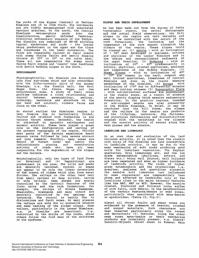
The rocks of the Higher (Central) or Tethyan Himalaya are 10 to 2 Okm thick, dip northwards and are highly metamorphosed with associated tertiary granites. To the north, the Central Himalayan metamorphics grade into the fossiliferrous, gently deformed CambrianOrdovician sedimentary sequence of the Tethys. The Siwaliks are comprised of NW-SE striking typical sandstones and sands the latter being predominant in the upper and the clays and claystones in the lower .succession. The folds are repeatedly faulted at their crests with steep strike faults and gently dipping thrusts at 250 to 300 to the north east. These all are responsible for steep south facing fault scarps and 'cuesto' type landforms with gentle bedding slopes to the north.
PHYSIOGRAPHY
Physiographically, the Himalaya are divisible into four sub-zones which are also concordant with the litho-tectonic units of the Lesser Himalaya, i.e. the Siwalik belt, the Krol Nappe Zone, the Almora Nappe and the Autocthonous zone. A study of their cross profiles indicates a close relationship and control between geomorphology, geology, lithology, tectonics and structure on the one hand and rainfall, climate fauna and flora on the other.
As stated earlier the Himalayan region is very fragile due to tectonically folded, faulted and crumbled rock formations in the various thrust sheets. Secondly, the region is subjected to sporadic earthquakes and seismic activity. These have played a great role in the configuration and carving of the present topography of the region. Thirdly most parts of the terrain experience heavy monsoon rains followed by long severe winters and long summers. Fourthly, many areas are devoid of forest cover and lastly the indiscriminate grazing and construction activity of roads etc. have all been responsible for the degradation of the slopes and the valleys.
Morphologically, only two types of land forms (a) Erosional and (b) Depositional are predominant in the area. The hills and peaks are generally isolated, conical in shape and appear to be only the linear extensions of the crests of ridges which also form water divides. The valleys on the other hand vary from small ravines to deep gullies, narrow or wide valleys. Deep gorges are mostly controlled by the tectonic features of the litho units and the rock formations, for example, the valleys of Rivers Ramganga, Bhagirathi, Alaknanda and many others are generally controlled by the geology and tectonics. The control is mainly due to dislocations and fault zones. At many pleaces the valleys are wide due to excessive erosion and mass wasting of the slided slopes. Some valleys, particularly in the Lesser Himalaya, e.g. in Siwaliks are homoclinal, i.e. controlled by the strike of the rocks, while others follow the fold exes of the antiforms or the synforms.
314
SLOPES AND THEIR DEVELOPMENT
As has been made out from the Survey of India topographic sheets, the aerial photographs and the actual field observations, the hill slopes in the region are very variable and seem to be controlled with the nature of the rock formations, the tectonics and the competancy of the rock masses alongwith the climate of the region. These slopes could be classed as: (1) gentle - with an inclination of < 300 best developed in gneisses, schists and phyllites of the Lesser Himalaya and in the shales and unconsolidated sediments of the upper Siwaliks, (2) Moderate with an inclination of 200 456 predominantly in schists, phyllites, crushed quartzites, gneisses and limestones of the Middle Himalaya, (3) Steep Slopes with an inclination of 45°
700 are common in the hard, compact and well jointed quartzites, limestones of Central Himalaya and even in the coarse massive sandstones of the Siwaliks, ( 4) Scraps with inclination of >750 due to differential erosion and deep cutting streams ( 5) Topographic Flats - with sub-horizontal surfaces are predominant in the stable zones, as a result of erosion of the gently dipping thick massive sedimentary formations. In the granitic regions, rounded or sub-rounded mounts are also noteworthy in the Middle Himalaya. In brief, it may be concluded that the hill forms, the slopes and the valleys in the region are products of the lithology, tectonics, dip failures, and structural deformations and discontinuities coupled with the variations in the climate and the erosive activity of waters along the weak planes and toe erosion.
LANDSLIDE AND LITHOLOGY
On an over view and evaluation of the land failures activity, it is noted that the clastic rock units of the Siwaliks are less susceptible to landslide activity. It may be due to the easy weathering of soft rocks producing good soils for luxuriant vegetation. The Nagthat quartzites, Krol limestones etc. and the low grade metamorphics (phyllites, schists and slates etc.) being well jointed, well foliated are less vegetated and show an higher incidence of landslide activity. The rocks of higher grade metamorphics and the crystallines i.e. granites, gneisses and quartzites alongwith the massive krol limestone (not influenced by weak characters) are comparatively less prone and affected by landslides only at few localities close to the major tectonic features like the NAT, MBF or MCT. However, the massive crushed, fractured and foliated rocks suffer of rock falls, rock debris, in the neighbourhood of the tectnic features/shears or weak zones, particularly when associated with meta-basics or epidiorites, (Table II, Fig.2).
Almost all thrust faults and shear zones are evidenced by the presence of breccia, crushed and gouged materials. Such characters are best observed particularly along the recent and Neotectonic (?) features. Along the other weak zones meta-basics or their weathering products are invariably present, e.g. AlmoraDubatoli-Bijnath thrust sheet in Kumaon; Main
Second International Conference on Case Histories in Geotechnical Engineering Missouri University of Science and Technology http://ICCHGE1984-2013.mst.edu

TABLE II. Characters of some Important Thrusts and Landslides zones along Bhagirithi Valley in Garhwal Himalaya
(Modified and compiled after Jain, 1972)
NORTH (Sai.nj)
CHARACTERS OF THRUSTS
Main Central Thrust (MCT)
Uttarkashi Thrust
Dunda Thrust
Singuni Thrust
Srinagar/ North Almora Thrust (NAT)
Impersistant chlorite schist, increase in metamorphic effects towards top of Gamri quartzites near thrust; development of foliations, mica lineation and quartz sericite schist.
Persistent metabasics,metamorphic effects maximum, wherever metabasics are absent development of foliation, mica lineation and schistose quartzite.
Persistent metabasics,metamorphic effect minimum wherever metabasics are thick
Impersistent mylonites,increasing metamorphic effects towards the sole of the thrust in. Gamri quartzites, development of foliation, mica lineation and quartz schist.
Impersistent metabasics, increased metamorphic effects in Dharasu formation along thrust zone, crushing of rocks
CHARACTERS OF LANDSLIDE
Intensely crushed, 3-5km wide zone on the sub-thrust side, zone of intense landslide, e.g. Sainj landslide.
Highly crushed and friable zone of 1.5 to 3krn in width landslide zone with flowing highly crushed material e.g. Netala landslide.
Highly crushed zone of 1 to 2.5km width, metabasic blocks in flowing debris.
Highly crushed limestone zone along Tehri-Dunda Road crushed zone upto 1.5 to 2km wide e.g. Khattukhal slides.
Intermediate width (upto 1.5 km landslide zone of angular blocks and crushed rocks in flowing slide zone, e.g. Nail slide north of Dharasu
>< u z ·JZI 0 01
~ Q'
~ til 1:!:: IZl
·~ z JZI Q H ..:I til
·:z:· H
IZl
~
------------------------------------------------------------------------------------~
SOUTH' <Rajpurl
Tons Thrust
Basul Thrust
Krol Thrust
Main Boundary Fault (MBF)
Fault breccia and crushed slate, lack of metamorphism
Sericite quartz schist and schistose quartzites in thrust zone, increase in metamorphic effects,development of foliation and mica lineation.
Fault breccia, crushed Chandpllr phyllite, friable carboneceous ~atter, lack of metamorphism, typical of other thrusts in foothills
Fault breccia, crushed and powdered material.
315
Narrow zone of crushed rock material, also rock slides, 150 to 200m wide one, e.g. Nagun slide.
Localised landslides zones along less significant thrust faults, e.g. Jakh slide on the Tehri Chamba road.
100 to 200m wide landslide zone of crushed and massive rock materials persistent, evidence of holocene movements, e.g. Rajpur Toll Barrier slide. Narrow, intermittent landslide zones of·crushed rock material dip-slip slopes more problematic.
H
"" 0
>< E-< H ..:I H a! H til til 0 c..
Second International Conference on Case Histories in Geotechnical Engineering Missouri University of Science and Technology http://ICCHGE1984-2013.mst.edu

l2i'::i3 Kha.ttullhal l.ltN•tOftt ~ Dunda forn'\atlon
§ pharasu FotMGliOI\
D Go.mrl Quartzite
~ Ctntto.l Crys!Olllne Grow
~ .,.etaba&lcs along thrwal
X
...._...,_.._...._..~~_,,.._,..__......_~Other mdaboalcs.
0 ''"'
y
Fig. 2(a) GEOLOGICAL MAP AND CROSS SECTION ALONG X-Y SHOWING DISTRIBUTION OF METABASICS IN DTTARKASHI AREA
Central Thrust, Uttarkashi Thrust, Singuni and North and South Almora Thrusts in the Kumaon-Garhwal region and Uttarkashi, Singuni, Tons, Srinagar, Krol thrusts etc. in the Garhwal area. These metabasics are highly prone to weathering and erosion. They give rise to brownish clays very similar to the 'bole' overlying the Deccan traps. This bole clay is expensive and rich in montmorillonite types of clay minerals. It flows on wetting, sometimes carrying huge blocks of massive competent rocks during rains or even later as at Kaliasaur on the Badrinath road or near Dunda etc. localities on the Tehri Uttarkashi road. Similar flowing brownish clayey mass has also been observed in a tunnel being excavated (August-Sept. 1987) for the Maneri (Stage II) Hydro power scheme, a little north of Uttarkashi.
Following the postulations of Reed (1964) for the correlations of metabasics and their characters along the Alpine faults in New Zealand, the marked occurrence of brecciated and mylonitised or weathered meta-basics (in Garhwal-Kumaon Himalaya) may also lead in deciphering their depths and the deepening or shallowing of the faults and thrusts. The main characters of certain important thrusts and the associated landslide features are shown in Table II.
On considerations of the morphology, litho logy and tectonics of the Garhwal-Kumaon region it may be suggested that the estimation of the depth of slip surfaces and crown cracks should form essential aspects of the investigations of landslides in the Himalayan terrain before any preventive measures for their control are adopted.
316
. t LANDSLIDE ZONES AND THE MAJOR GEOLOGICAL UNITS OF THE RAMGANGA
CATCHMENT AREA
.,. '!I'
Fig.2(b) MAN MADE SLIDES IN RAMGANGA BASINS
DISTRIBUTION OF LANDSLIDES
As a sample for discussion, the Ramganga basin is chosen as an example. On a study of more than 500 landslides, it is concluded that in the (four sub-basins) the number of recent slides is comparactively more, where certain developmental activities are in progress. Similar phenomena are also observed along the pilgrim routes of RishikeshBadrinath-Rudraprayag-Kedarnath and RishikeshUttarkashi-Gangotri roads etc. Wherever the new alignments occupy the old section~ of these roads the sliding activity is almost absent or the slopes are least affected.
LANDSLIDE SIZE AND PERCENTAGE OF ACTIVITY
It has been noted that the recent slides are many times more in number and are mainly medium in size. Very large or giant sized slides are almost absent in the region, while the smaller ones are inumerab,_e and not taken into consideration for this discussion. Table III shows the percentage of the mapped slides (522 Nos) in Ramganga Basin both in the field and on the aerial photographs:
In addition to the above, the major ~lide zones lie in the sparsely vegetated areas followed by in the agriculatural strips of lands (irrigated and unirrigated) and maximum in the deforested and barren slopes. The decidous forests suffer the least while the coniferous zones are appreciably more afflicted with medium slides.
s
Second International Conference on Case Histories in Geotechnical Engineering Missouri University of Science and Technology http://ICCHGE1984-2013.mst.edu

TABLE III.Percentages of Recent and Old Slides (After Joshi 1987)
Type Recent
Giant size Absent lOO,OOOm2
Very large 0 •4% 70-lOO,OOOm2
Large 2.6% 35-70,000m2
97.0% MediumSmall 5000-35,000m2
Old and Recent
Remarks
2.7% The giant size slides appear to be historic
4.1% Comparatively old and large sized slides may be due to repetitive failures till the angle of repose is reached.
24.6% Majority of these slides occur in low grade metamorphics followed by Infra Krol slates,shales, quartzites,granites and gneisses.
68.5% Some of the smaller and medium slides appear to have been washed out in time.
SHAPE
Elongated
Equidimensional
24-26.5% 24-26%
> 70% > 60%
Elliptical 3-14% 8-15%
LANDSLIDE ACTIVITY AND NEARNESS TO TECTONIC CONTACTS
Of the over 500 landslides, the majority of these occur within short distances of l-1.5km from the tectonic contacts. Further away the number of failures gradually decrease. From this, it is inferred that the slide zones lie close to the tectonic features (regional thrusts and faults or even to the local faults). A review of the litho-tectonic units (Tables I and II) in the area also support such an inference, from which it is noted that the maximum number of hazardous slides ·occur in the belt (Fig.l) between the MBF Srinagar thrust or the NAT and SAT and the MCT coupled with the minor and local structures affected by Neotectonics, e.g. near Dhrasu, Maneri, Ganganani etc. on the Tehri-Gangotri road, while along the Rishikesh-Badrinath road active zones are observed close to Pipalkoti, Joshimath, confluence of Patalganga and Alaknanda, the middle reaches of R. Birehi Ganga and near Nandprayag etc. etc. From the frequent slides and the percentage of landslides, it is also easily inferred that the dynamic forces are still active.
As a result of the landslides the morphology of the region has become rugged and exhibits
317
an awsome picture of the barren mountain slopes, the hill sides or even in the once forested valleys. The hill sides are steeply scared, hallowed and gullied, devoid of vegetation and serve important clues for the identification and recognition of the major tectonic and thrust zones on the aerial photographs. From Table III. (recent and old slides) it is evident that the new and recent slides far outnumber the older ones. Human activities (including agriculture) coupled with deforestation, road and bridge constructions etc. on the fragile hill slopes are equally responsible for the degradation of the unstable slopes mainly due to the disturbances of the angles of repose. To sum up, Table IV gives the relationship of the gee-environments and landslides.
TABLE IV. Gee-Environmental Factors commonly Associated with Landslide Zones (Based on the study of the four selected sub-basins of Ramganga - after Joshi, 1987)
Geo-Environmenmental Factor
Rock types
Land use type
Azimuth directions
Proximity to shear zones
Relief of the area
Ruggedness of the area
Landslides more Landslides less Common common
Massive quartzi- Limestone, tes, slates, dolomite, shale,Phyllite gneisses. and Schists
Barren or sparsely vegetated areas.
North-east, South-West and West facing slopes.
Areas lying within the range of 3kms distance from the shear contact Areas of higher relief and steep slopes
Forests,agricultural lands
North,North-West South,South-East amd East facing slopes
Areas lying away by 3kms distance from the shear contacts.
Areas of low relief and gentle slopes
Areas of the Areas of higher lower ruggedness ruggedness and and less develop-well developed ed drainage net drainage net work work.
From the above, it is considered that the Nagthat quartzites, Infra Krol slates, shales and siltstones and the low grade metamorphics of the region are relatively moderate to landslide activity, while the other formations are comparatively less prone. Whereas when these lie close or are affected by a tectonic feature they are highly susceptible to slides or rock falls. In the inner higher parts of Himalaya particularly close to the MCT the massive jointed rocks or the crystallines and gneisses with steep slopes are more prone to the rock falls. These are thus highly hazardous for road and bridge works or for any other developmental activities.
Second International Conference on Case Histories in Geotechnical Engineering Missouri University of Science and Technology http://ICCHGE1984-2013.mst.edu
meta-basics or 'bole' clay.
its weathered product
5. In order to visualise the magnitude, the calamitic effects and hazards caused by a particular landslide, attempt must be made to determine the depth of the slip circle and the amount and passage of percolation.
6. While treating a landslide zone, original angle of repose of the rock debris mass should be maintained as as possible.
the or
far
7. Large scale toe erosion is reponsible for feeding the large number of rivers with huge amounts of sediment loads, and is a major cause of siltation in the river channels/reservoirs and even on the flood plains.
8. The dynamic activity is still continuing as indicated by recent disturbances affecting the collovium and terrace deposits along the river channels.
ACKNOWLEDGEMENT
The author is grateful to Drs A.K.Jain, H.Sinvhal, R.P.Gupta of the University of Roorkee and G.S.Mehrotra of CBRI, Roorkee and B.C. Joshi, Senior Research Fellow, Dept. of Earth Sciences, University of Roorkee for their critical discussions and suggestions. The author has freely made use of the thesis and dissertations of his past students and published or unpublished works and his personal unpubished materials, data and reports on the topic collected during the past more than a quarter of a century. He is much obliged to Dr.S.Prakash for inviting him to write this article. Thanks are also due to Mr.P.N.Zutshi, a close friend for going through the manuscript and Shri K.V.Gangadharan for assistance in the preparation of the paper.
REFERENCES
Auden, J.B. (1934), "Structure of the Himalaya in Garhwal", Reed. Geol. Surve. Ind., Vol. 71, pp.407-433.
Gansser,A (1964),"Geology of the Himalayas", Interscience Publishers, London.
Gaur, G.C.S.(l974) Ph.D. Thesis (unpublished), "Geology and Magnesite Deposits of Chamoli Garhwal Himalayas', Dept. of Geology and Geophysics, University of Roorkee, Roorkee, U.P.
Jain, A.K. (1972) Emplacement of basic Garhwal", U. P .. Jour. No.3.
"Overthrusting and rocks in Lesser Himalaya, Geol. Soc. Ind. , Vol.l3,
Jain, A.K. (1987) "Kinematics of transverse lineaments, regional tectonics and holocene stress field in the Garhwal Himalaya", Jour. Geol. Soc. Ind., Vol.30, No.3.
Joshi, B.C.(l987) -Ph.D. Thesis (unpublished), "Gee-environmental studies in parts of Ramganga catchment, Kumaon Himalaya", Dept. of Earth
319
Sciences, University U.P., India.
of Roorkee, Roorkee,
Joshi, B.C., Gupta, R.P. and Mithal, R.S. ( 1987 l, "Landslide studies and hazard zoning in Ramganga catchment, Kumaon Himalaya "Com. to Indian Journal of Earth Sciences.
Krishnaswami, V.S. and Jain, M.S. (1975) "A review of some of the major landslides in northern and north-eastern Himalaya", Seminar on Landslides and Toe Erosion Problems, Him. Region, ISEG, Sikkim (India).
Mithal, R.S. and structural Chapter III in Ed. B.C. Law, 1968.
(1968), "The physiographical evolution of the Himalaya",
Mountains and Rivers of India, 21st Int. Geog. Cong., India,
Mithal, R.S. (1984), "The physical impact of the Rihand and Ramganga Dam Project on the drainage basin and their catchment areas", Emeritus Scientist Scheme Report completed during 1.1.1983 to 31.12.1985. Extra Mural Research Division, C.S.I.R., New Delhi-12.
Mithal, R.S., G.C.S. (1972) R.Birehi Ganga, Vol.2
Chandsarkar, R.A. and Gaur, Geomorphic Studies of the
Garhwal Himalaya, Him. Geology,
Pandey, I.C. (1949), "A note of the epidiorite sills of Ramgarh area, Dist. Nainital, Q.J.M.M.S., India, Vol.21,
Reed, J.J. (1964), "lMylonites cataclastics and associated rocks along the Alpine faults, South Island, New Zealand, Jour. Geol. and Geophy., Vol.?, pp.645-684.
Valdiya, K.S. (1980), boundary thrusts Tectonophysics, Vol.66
"The of
two Intra crustal the Himalaya" ,
Valdiya, K.S. (1980), "Geology of Kumaon Lesser Himalaya", Wadia Instt. of Himalayan Geology, Dehradun, India.
Valdiya, K.S. (1985), "Accelerated erosion and landslides prone zones in the Central Himalayan region", Environmental Regeneration in Himalaya, Central Himalayan Environmental Assoc., Nainital.
Valdiya, K. S. ( 1986 l, "Neotectonic activities in the Himalayan belt, Int. Symp. on Neotectonics in South Asia, Survey of India, Dehradun (India)
Varnes, D.J. (1978), "Slope movement types and processes in landslides, analysis and control", Spl. Report, Ed. Schuster, R.L. and Krizek, R.J., Transportation Resch. Board, Nat. Aced. Sc., Washington, D.C., U.S.A.
Wadia, D.N. and West, W.D. (1964), "Structure of the Himalaya", Int. Geol. Cong. , 22nd Sese, India. pp. 1-30.
Second International Conference on Case Histories in Geotechnical Engineering Missouri University of Science and Technology http://ICCHGE1984-2013.mst.edu