Embed Size (px)
Citation preview
Liverpool Civic Improvement Plan Liverpool Contributions Plan 2007
(Liverpool City Centre) December 2007
Refer to Liverpool Contributions Plan 2006 – (Edmondson Park)
for local facilities in Edmondson Park
Refer to Liverpool Contributions Plan 2001
for all other areas in Liverpool.

Liverpool City Centre Contributions Plan 2007 2

Liverpool City Centre Contributions Plan 2007 Table of Contents 3
Liverpool Contributions Plan (Liverpool City Centre 2007)
Table of Contents 1. Introduction ...........................................................................................................4 2. Schedule of Contributions ......................................................................................5
2.1 Objectives................................................................................................................................6 2.2 Public Domain Framework.......................................................................................................7 2.3 Street Types.............................................................................................................................7 2.4 Parks Strategy........................................................................................................................12 2.5 Tree Planting Strategy..........................................................................................................14 2.6 Paving Strategy .....................................................................................................................16 2.7 Public Art Strategy.................................................................................................................19 2.8 Lighting Strategy ...................................................................................................................19 2.9 Urban Furniture Strategy .......................................................................................................20 2.10 Signage Strategy .................................................................................................................20 2.11 City Ecology Strategy ...........................................................................................................22
3. Special City Centre Projects ..................................................................................23 3.1 Georges River Foreshore Improvement and Bridge Connection ............................................24 3.2 Bigge Park Landscape Upgrade .............................................................................................25 3.3 Pioneer Memorial Park Embellishment .................................................................................27 3.4 Woodward and Collimore Parks.............................................................................................28 3.5 District Community Facility ....................................................................................................28 3.6 Car Parks, Intersection Upgrades and Bus Priority .................................................................28 3.7 Existing Library and Whitlam Centre......................................................................................30 3.8 Stormwater Management .....................................................................................................30
4. Section 94A Development Contributions Plan......................................................31 4.1 Introduction ...........................................................................................................................31 4.2 Payment of Levy....................................................................................................................32 4.3 Payment Procedures..............................................................................................................34 4.4 Administration of Section 94A Funds.....................................................................................35 4.5 Expected Development and Demand for Public Facilities......................................................35
Appendix 1...............................................................................................................36
Liverpool City Centre Contributions Plan 2007 Introduction 4
1. Introduction
This Civic Improvement Plan for the Liverpool City Centre provides a description of the civic infrastructure needed to support the growth and development of the city centre, and outlines the framework for contributions to be made towards the funding and provision of the infrastructure in association with future development in the city centre.
This Plan is one of four documents prepared jointly by the Department of Planning and Liverpool City Council for the Liverpool City Centre as part of the Cities Taskforce established by the Minister for Planning. The four planning documents comprise a Vision, Local Environmental Plan (LEP), Development Control Plan (DCP) and Civic Improvement Plan (CIP). The LEP has since been incorporated into Liverpool LEP 2008 while the DCP has been incorporated into Liverpool DCP 2008.
This Civic Improvement Plan is a critical component to achieve the high quality urban design and public domain character for the Liverpool City Centre as described in the accompanying Liverpool City Centre Vision document. The Vision establishes the nexus between growth, development and the need for public domain projects and special city centre projects identified in this Civic Improvement Plan. This Plan sets design principles and incorporates design strategies for the public domain and special projects needed to support growth and development in the city centre permitted under the accompanying LEP and DCP. It guides the funding and provision of this civic infrastructure. The development of these special projects is integral to the successful revitalisation and growth of the city centre. The Civic Improvement Plan includes public domain projects for paving, street trees and urban furniture which are important components of the character of the city centre.
The special city centre projects are to be partly funded by monetary contributions levied from new development in the city centre under Section 94A of the Environmental Planning and Assessment Act 1979 (EP &A Act) as shown in the following tables. The public domain streetscape works are being primarily funded by Council’s Town Improvement Fund, and the stormwater management works will be primarily funded under Council’s capital works program.

Liverpool City Centre Contributions Plan 2007 Schedule of Contributions 5
2. Schedule of Contributions
Table 1: Summary of City Centre Projects
Project Cost Primary funding source
Public domain streetscape works $25,000,000 TIF
Georges River foreshore $14,000,000 s94A
Bigge Park $3,000,000 s94A
Pioneer Park $3,000,000 s94A
Woodward and Collimore Parks $2,000,000 s94A
District community facility upgrade $425,000 s94A
Access – car parks, bridge link, bus priority $15,800,000 s94A
Library and Whitlam Centre recoupment $775,000 s94A
Stormwater management $9,900,000 CWP
Total $73,900,000
CWP = Capital works program TIF = Town improvement funds
Table 2: Summary of Development Contributions
Zone S94A Levy
B1 Neighbourhood Centre, B3 Commercial Core, B4 Mixed Use and B6 Enterprise Corridor zones
3% of the cost of development
R4 High Density Residential and IN2 Light Industrial zones 2% of the cost of development
Note: S.94A contributions for the commercial core zone are applied to the car parks. S.94 contributions from all other zones are not applied to car parks
The principles set out in this section of the Civic Improvement Plan provide an urban design framework for the city centre as a whole. This underpins the capital works projects and infrastructure improvements envisioned and planned for the city centre. This section summarises strategies for enriching and expanding the public domain and design parameters for streetscapes and key public spaces. The design strategies for the public domain are for:
- Street types;
- Parks and public squares;
- Tree planting;
- Paving;
- Public art;
- Lighting;
- Signage; and
- Ecology.
These public domain projects are estimated to cost $25 million and are being funded by Council’s Town Improvement Fund.

Liverpool City Centre Contributions Plan 2007 Schedule of Contributions 6
2.1 Objectives
The general objectives of the Civic Improvement Plan are:
a) Guide the development and implementation of Liverpool City Centre’s public domain improvement program;
b) Integrate the public and private domains;
c) Deliver an environment that is safe and free of overcrowding, nuisance and pollution;
d) Ensure that improvements are sustainable both in terms of energy consumption and economic, social and cultural vitality;
e) Encourage and value expressions of local identity;
f) Embrace difference and diversity and develop places that encourage participation and provide for a range of shared social, cultural and recreational activities;
g) Emphasis on a strong pedestrian focus and ensure equitable access across the Liverpool City Centre;
h) Cultivate an urban layout that is legible and offers a range of opportunities;
i) Accommodate and manage change and provide spaces that are flexible enough to meet a diverse range of needs and adaptable over time;
j) Ensure public places are of the highest design quality and provide a range of sensory and cultural experiences; and
k) Provide guidelines for the development and implementation of comprehensive maintenance and management strategies for the public domain.
The specific objectives of this Civic Improvement Plan are:
a) Encourage higher levels of pedestrian activity and street life;
b) Maintain purposeful links between different street hierarchies;
c) Develop pedestrian links, particularly improving mid-block access;
d) Protect and extend a fine-grain network of laneways within the city centre core (defined by the Ring Road);
e) Through these links, create a ‘pedestrian heart’ for Liverpool;
f) Upgrade pedestrian and cycling access to and from the Georges River;
g) Enhance and reinforce the city’s major civic spine of Macquarie Street as a pedestrian promenade;
h) Link major pedestrian generators into the overall pedestrian network;
i) Promote public art throughout the city centre
j) Give preference to pedestrian movement over vehicular traffic wherever possible;
k) Minimise pedestrian vehicle conflict
l) Protect, upgrade and extend the pedestrian network;
m) Improve public knowledge and awareness of the pedestrian network;
n) Enhance the legibility of the grid through prescribed, distinctive street tree planting;
o) Ensure a consistency in the physical treatment of areas;
p) Ensure that adjoining development compliments pedestrian functions and adds interest and vitality, particularly at street level; and

Liverpool City Centre Contributions Plan 2007 Schedule of Contributions 7
q) Achieve a balance between vehicle access needs and pedestrian amenity in main streets and laneways.
2.2 Public Domain Framework
Streets and open spaces form the public domain framework of the city centre connecting different precincts such as the rail station and bus interchange with the central retail core and mall, Georges River, TAFE, Hospital and school precincts.
A clear hierarchy of streets and movement corridors is proposed for the city centre, defined by use, location, setting and connection. Similarly a network of open spaces ensures a variety of recreational opportunities are provided.
2.3 Street Types
The streets of the city centre vary in scale, orientation, function and importance. The street typology is defined in this plan as a basis for future more detailed streetscape design strategies (see Figure 1).
Streets form the framework for the public domain, providing access to both private and public buildings, and linking open spaces and places of activity. Well designed streets can:
- enhance and strengthen the city’s legibility and hierarchy in the city context,
- create a convenient pedestrian network linking parks and public spaces, unifying the city and enhancing pedestrian and recreation experiences;
- improve amenity and reduce vehicle/ pedestrian conflict; and
- create a memorable image for the city centre.
The types of streets in the Liverpool City Centre are described below as:
- Entry Boulevards and Gateways;
- Ring Road
- Macquarie Street Mall and Civic Precinct
- North-South Streets
- East-West Streets
- Secondary Streets and Living Streets and
- Lanes and Service Ways
General objectives for streets
The general objectives for the streets in Liverpool City Centre are:
- Enhance vistas through the removal of visual ‘clutter’ such as overhead cables, telegraph poles and inappropriate and/or unauthorised signage.
- In the case of residential buildings street walls are set back from the street alignment with sustainably landscaped front gardens.
- Facilitate and promote differentiation of facade elements through articulation, loggias, balconies, awnings, screens and windows and the inclusion of visually prominent public art.
- Promote and facilitate appropriate illumination of the street edge, alcoves, overhanging verandahs and doorways. Promote a highly visual landscape experience with tree lined streets.
- Provide new footpaths, kerb ramps, lighting and landscaping where required.

Liverpool City Centre Contributions Plan 2007 Schedule of Contributions 8
Detailed strategies for individual streets and objectives for each street type are provided in Council’s Public Domain Strategy.
Entry Boulevards and Gateways
The main entry boulevards and gateways are:
The southern section of Macquarie Street and Terminus Street, Hoxton Park Road and Newbridge Road and Elizabeth Drive are the main entry boulevards to the central city centre street grid.
The Primary Gateway at the intersection of the Cumberland Highway/ the Hume Highway/ Brickmakers Creek.
Moorebank Avenue and Heathcote Road at the intersection of Newbridge Road to create a main approach to the southern city
The Primary Gateway at the intersection of Hoxton Park Road/ Macquarie Street/ Hume Highway/ MiIl Road. centre, across the Georges River.
Southern Macquarie Street at Hoxton Park Road provides the entry to the civic heart of Liverpool.
Terminus Street is a central entry point leading to the Ring Road. It is also a continuation of Newbridge Road. Hoxton Park Road, Newbridge Road, Southern Macquarie Street. Terminus Street will be distinguished with a tall columnar tree species with golden autumn foliage – Populus x deltoides (Kawa Poplar).
Hoxton Park Road and Newbridge Road will be avenue-planted with this tree species to the extents of the Liverpool Local Government Boundary.
The Terminus Street ridge will be distinguished with tall buildings of outstanding architectural merit functioning as a street defining urban wall.
Elizabeth Drive is a major vehicle connector linking Liverpool with the Nepean Valley as far as The Northern Road near Badgery’s Creek. It connects Liverpool with new and existing suburbs between the Liverpool floodplain and the foothills of the Blue Mountains.
Gateway sites and intersections are proposed to be marked with a hierarchy of prominent ‘Gateway’ structures. These have equal impact through innovative Iighting at night. Gateways are clearly marked with groups of distinctive, tall and iconic trees of the Araucaria family, long-lived trees such as oaks and colourful, seasonal display garden beds, and iconic public art. Architecturally innovative buildings should be provided on prominent corner sites.
Ring Road
The core city centre – the retail and commercial heart – is defined by the Ring Road and is contained within Bathurst Street, Campbell Street, Bigge Street and Pirie Street.
The Ring Road carries the bulk of through traffic around the core city centre to access the major arterials – Newbridge Road, Hoxton Park Road, the Hume Highway, Elizabeth Drive and the Cumberland Highway. The Ring Road allows for the fi ne-grain preservation of the pedestrian core.
The nominated tree species will distinguish the Ring Road with a tall columnar tree canopy form and flame-red autumn colour of the Acer saccha-rum (Sugar Maple).
Objectives for the Ring Road include:
- Achieve traffic calming and redirection of through traffic.
- Define the edge between the pedestrian city core and the outer city centre.
- Facilitate traffic movement around and out of the city.
- Prioritise public transport and provide a pedestrian focus within the core city centre.

Liverpool City Centre Contributions Plan 2007 Schedule of Contributions 9
- Provide drivers with intuitive way finding cues to enable easy access from the arterials via connecting roads into the city centre.
- Provide short term public parking locations off the Ring Road.
Macquarie Street, Macquarie Mall and the Civic Precinct
Macquarie Street and Mall is the central retail spine of the city centre and historic Robert Hoddle Grid which forms the definitive urban framework on which the Liverpool City Centre was developed. It is the key city axis and ceremonial Liverpool Street. It is highly valued as a pedestrian corridor.
Before the closure of the Mall to through traffic, cars and trucks were often banked up for whole blocks as the old Hume Highway passed through the city. Exhaust fumes and noise discouraged people from walking through the city’s main artery. The closure was an acknowledgment of the street’s pedestrian value ahead of its role as a highway.
The widened footpaths are paved with distinctive and artistic paving, trees were planted, seasonal flower beds and consistently designed street furniture installed. Outdoor dining and a high level of day time street activity make this a great civic and celebratory street. The street is increasingly becoming a vibrant and active public space through growing numbers of pedestrians as the city’s resident, working and visitor population increases.
North-South Streets
The city centre grid consists of six long north-south streets and four short north-south streets. Some of these streets have been truncated by public park and facility spaces as well as by the Westfield Shopping Centre. The north-south blocks are longer than they are wide.
The north-south streets include Bathurst, Bigge, Castlereagh, George, Northumberland, Goulburn, Forbes, Drummond and Hart Streets and Browne Parade.
Each north-south street has been defined as an “Avenue” with evergreen trees for year-round shade. There are two distinctive species for each avenue – Magnolia grandiflora ‘Exmouth’ and Harpullia pendula (Northumberland Street and George Street). There is a specific pavement, streetscape treatment and tree species for the public streets.
East-West Streets
The north-south streets are intersected by five east-west streets. Two of these are extensions of wide avenues from the west – Elizabeth Street and Memorial Avenue. One of the east-west streets, Moore Street, is the Liverpool-Parramatta Transitway route.
The east-west streets include Lachlan, Campbell, Elizabeth, Moore, Scott and Railway Streets and Memorial Parade.
Each east-west street of the grid is a “Boulevard’ with deciduous trees to provide winter solar access and summer shade. A distinctive species is nominated for each east-west street. There is a specific pavement, streetscape treatment and tree species for the public street abutting any development.
Secondary Streets and Living Streets
To the south of Memorial Avenue/ Scott Street, the street alignment diverges from the Hoddle Grid to accommodate the sharp change in topography. The divergence provides opportune street corner relationships – each street forms one arm of a “Y” link as they depart from the grid.
The “Y” link intersection of Castlereagh and Norfolk Streets forms the southern termination of an important vista down Castlereagh Street. It also signals the southern most point of the historic Robert Hoddle Grid. The south-west edge of the intersection is a visually prominent site when viewed from Castlereagh Street. Two tall Phoenix canariensis palm trees frame the view from Castlereagh Street as it turns the corner and departs from the grid.

Liverpool City Centre Contributions Plan 2007 Schedule of Contributions 10
South of Terminus Street, the Living Streets Precinct and the Georges River corridor are the dominant urban strategies that determine development of the public domain. The Living Streets Precinct borders the Georges River corridor and includes Speed Street, Shepherd Street/ Riverpark Drive, Atkinson Street, Mill Road, Charles Street, Nagle Street, Carey Street, Hay Street and Olive Street. The Georges River Corridor Plan of Management and Living Streets Principles and Policy Documents also provide strategies for this precinct.
Lanes and Service Ways
The street grid is interspersed with lanes and serviceways each with its own intimate pedestrian character. The city’s laneways are one of the unique characteristics of Liverpool, an urban form shared only with Melbourne. Laneways are potential sites for cultural events, innovative small businesses and intimate 24-hour bars, shops and restaurants. The laneway network both complements and contrasts with the dominant qualities of the main streets. Their narrow proportions and often sheltered atmosphere have a potentially unique charm. Hidden within the blocks, they can provide a set of spaces that diversify and enrich the City, in the same way that Melbourne’s laneways, ‘little’ streets and arcades have enriched its liveability.
The environment of the lanes is of great importance to the city. Council promotes a policy that all lanes in the city centre must be properly considered for their current and potential amenity, particularly relating to:
- the height and form of abutting buildings;
- the protection of vistas, views of the sky and the provision of natural light;
- the nature of materials used in abutting buildings; and
- bridges, overhangs or structures over lanes are to be minimised

Liverpool City Centre Contributions Plan 2007 Schedule of Contributions 11

Liverpool City Centre Contributions Plan 2007 Schedule of Contributions 12
2.4 Parks Strategy
Parks and public spaces (see Figure 2) should provide a range of public amenity that provides for the needs of all members of the community. These spaces join with streets to provide a public domain network with a variety of recreation opportunities. The design of each space should reflect the function of the place, its existing or potential character, and its place in the overall structure and hierarchy of the public domain.
The Liverpool City Centre has its main areas of open space as:
- Bigge Park on the eastern edge;
- Pioneer Memorial Park on the northern end;
- Light Horse Park on the southeast corner;
- Apex Park on the northwest corner;
- Woodward Park and Collimore Park to the immediate west on the outskirt of the city centre; and
- Park near Hart Street.
Bigge Park is the original civic square of Liverpool and has historic significance itself as well as being part of the setting for surrounding heritage areas and buildings. It is used relatively intensely due to its location next to the rail station, hospital and TAFE. Pioneer Memorial Park and Apex Park also have heritage significance as former cemeteries and are used for passive recreational use. Light Horse Park provides passive and active recreational opportunities on the river front. Woodward and Collimore Parks provide active and passive recreational spaces including for structured sports.
The park strategy is to reinforce the role and function of these parks. The special city projects include landscape improvements to Bigge Park and Pioneer Memorial Park.

Liverpool City Centre Contributions Plan 2007 Schedule of Contributions 13

Liverpool City Centre Contributions Plan 2007 Schedule of Contributions 14

Liverpool City Centre Contributions Plan 2007 Schedule of Contributions 15
2.5 Tree Planting Strategy
Street trees play an essential role in modifying climate and improving amenity. Liverpool experiences temperature extremes significantly higher in summer and lower in winter than Sydney’s coastal commercial centres. The appropriate selection and planting of street trees, in particular, can alleviate these temperature extremes. The development and implementation of the tree planting strategy contribute to the quality of life and streetscape amenity in several other important ways. Street trees:
- Provide shade and solar access in summer and winter;
- Signal that Liverpool is the major commercial centre for South-West Sydney;
- Distinctive street trees and landscaping aid in understanding city layout;
- Provide colour, movement and seasonal variation through the selection of evergreen and deciduous trees;
- Increase residential and commercial property values and generate increased business activity through the creation of a sustainable asset – street trees;
- Ensure a ‘Green City’ for future populations; and
- Foster a sense of pride in the city centre – contributing to the city’s ‘liveability’.
Tree Species Selection
The tree planting strategy provides for medium to tall evergreen and deciduous trees that are known to perform well over the planned lifecycle of trees in the urban landscape. Selection of deciduous trees is to be balanced against their contribution of unwanted nutrient enrichment of local waterways. Evergreen trees such as Southern Magnolias and Tulip Woods are to be planted along the north-south ‘avenues’ of the city grid and deciduous trees such as Chinese Tallows and Claret Ash are to be planted along the east-west ‘boulevards’. The Sugar Maple, which turns a fiery red in autumn, will be planted along the Ring Road. Tall distinctive Date Palms and Cabbage Palms are designated as centre plantings along Terminus Street and the Hume Highway, and the stately Kauri Pine will be planted at Gateway sites leading into the city centre and other designated locations.
Landmark sites located at the termination of view corridors and significant intersections within the city centre are planted with very large, broad canopied tree species such as Hills Weeping Fig, Port Jackson Fig or Cotton Palms planted in a group. A typical location is the corner of Bathurst Street and Norfolk Street.
Tree planting in the street hierarchy
The city’s ‘boulevards’ – generally the east-west streets of the Liverpool street grid – are planted (see Figure 3) with medium to tall deciduous trees. They provide for maximum shade in summer and solar access in winter.
The city’s ‘avenues’ – generally north-south streets of the Liverpool street grid – are planted with medium to tall evergreen trees. They provide shade for the footpath all year round as well as reinforcing the strong north-south street alignment.
The city’s ‘Ring Road’ has generally been planted with the deciduous, distinctive and colourful Sugar Maple, Acer saccharum, which turns firey red in autumn.
The city’s major entry roads are generally planted with double rows of tall distinctive and colourful deciduous or semi-deciduous trees and centre median plantings of tall palms.
Designated ‘Gateways’ to the city are the sites of architecturally significant buildings / illuminated signs of artistic merit and very tall, broad and long lived trees of the Araucaria, Ficus or Quercus (Oak) family.
Technical details on tree planting and species selection are provided in Council’s Street Tree and Landscape Strategy.

Liverpool City Centre Contributions Plan 2007 Schedule of Contributions 16
2.6 Paving Strategy
Footpaths can be a unifying element in the streetscape where buildings, signs, objects, people and movement provide constant variation and change (see Figure 4). They are to give a clear expression of pedestrian priority and this message must be obvious to pedestrians and drivers. Continuity of footpath dimensions, levels, materials and edges is therefore important. Permanent and semi-permanent objects such as kerb ramps, footpath crossings and street furniture are to appear as occasional interruptions in the overall pattern rather than dominant elements of the streetscape. Footpaths must provide ease of movement for everyone, including people with different degrees of mobility. Visual simplicity and observation of pedestrian desire lines is important as is the use of contrasting pavement textures and markings to alert street user to potential hazards such as intersections and footpath crossings.
Paving types
The technical details apply to all developments in the area covered in Figure 4 Liverpool Paving Strategy including the Council’s footpath construction and restoration work. The Paving Strategy identifies types of paving finishes to be used in Liverpool’s city centre. Paving areas are broadly defined by intensity of use, both current and planned, and by the Ring Road, which directs through vehicular traffic around the city core.
Technical details on paving types are included in Council’s Streetscape and Paving Guidelines.
Core Paving
Core paving is located along major pedestrian streets such as Macquarie Street, within the main commercial and retail precinct and areas of high profile within the Ring Road.
Periphery Paving
Periphery paving is located in areas within the city centre but beyond the Ring Road and generally towards the edge of the city centre.
Laneways
Key laneways have been identified and will be integrated to complement the adjoining footpath treatments. Appropriate paving, kerbing and detailed design of laneways will depend on the functional role of each lane.
Kerb Ramps
For visual consistency, kerb ramps should appear as subtle depressions in the pavement. They are to be paved with the same materials as the surrounding footpath, in accordance with the standard detail for each paving type. For proper continuity and edge definition, kerbs and header course margins are to continue uninterrupted along the length of the street and be set down at the kerb ramps to match their profile. At footpath corners and street intersections kerb ramps should be located within the corner area of the footpath, aligned with the street wall and set at a straight angle to the street alignment. This arrangement corresponds to pedestrian desire lines, provides a stable crossing for people using wheelchairs and directs people in a straight line to a safe crossing to the opposite footpath. Kerb ramps must not be placed diagonally at the footpath corners as this provides no protection for pedestrians from the wheels of turning vehicles and misdirects people with sight impairment into the intersection in the path of vehicles.
At any irregular intersections and when a large corner radius is required, the location and alignment of the pedestrian crossings and kerb ramps is to be designed simultaneously for the whole intersection to avoid inconvenient and dangerous mismatch of facing kerb ramps.
Liverpool City Centre Contributions Plan 2007 Schedule of Contributions 17
Vehicle Crossovers
Vehicle crossovers are required to provide vehicular access to car parks and service bays across the footpath. Where installed they are to be constructed at footpath levels and paved with the same material as the surrounding footpath, to match the standard detail for each paving type. For proper continuity and edge definitions, kerbs and header course margins are to continue uninterrupted along the length of the street and be set down at the vehicular crossings to match their profile. Vehicle crossovers may only be separated by kerbs in exceptional circumstances. Recessed double vehicular crossings have an adverse impact on pedestrian amenity and are not to be constructed along the major pedestrian thoroughfares.
Footpath Extensions
Footpath extensions increase pedestrian presence on the streets and have a significant effect on its user pattern and civic image. They are to be constructed according to an overall plan that takes into account relevant urban design, heritage and traffic issues. All footpath extensions must have a precise, geometric form and a sufficient length to contribute to the linear quality of the streetscape and the visual continuity of the pedestrian realm. As the first priority, existing footpaths are to be retained and extensions constructed on the surface of the carriageway at its grade. The original kerb is to be relocated at the new alignment. The original kerb line will become the new low point and the original kerb substituted by a grate. New pits are to be installed where necessary. This implementation principle allows incremental improvement of footpaths, that is, first stage paving followed by second stage extension, without loss of completed work. It retains the memory of the original kerb alignment which contributes to the temporal layering of the streetscape and adds richness to people’s experience of the urban environment. Narrow footpath extensions may be constructed by continuing the footpath at its existing grade into the carriageway, provided that a minimum kerb height of 100 mm can be achieved at the new alignment.

Liverpool City Centre Contributions Plan 2007 Schedule of Contributions 18

Liverpool City Centre Contributions Plan 2007 Schedule of Contributions 19
2.7 Public Art Strategy
Public art is an important way to build on the identity of the city. It has a role in way finding, to improve legibility, and in place making – interpreting the physical character and defining a cultural identity. It can also engender civic pride and promote the city’s regional and national significance.
Public art ranges from the monumental to the ephemeral. Expressions of public art include:
- free standing art objects;
- artists’ involvement in the siting, layout and design of public spaces – the design of a space in an artful way;
- artists’ involvement in creating specific site elements such as paving, street furniture, and fountains;
- ephemeral new media and lighting projects that may include buildings and structures as part of a temporary artwork; and
- festivals and other cultural events.
Public art is encouraged in the open spaces and streets of the public domain, and particularly in the Living Streets project. A commitment to the funding of artworks, and involvement of an artist is desirable at the inception of each project. The artist should have the opportunity to work with urban designers and landscape architects and the community at the planning stages of each project, to be able to develop an appropriate strategy for each place.
A strategy for public art should also consider the hierarchy of streets and places in planning and funding artworks.
2.8 Lighting Strategy
A lighting strategy aims to enhance the character of streets and public places, and reduce street clutter where possible. It allows for a level of commonality through the city, with opportunities for particular lighting schemes in special places. The lighting strategy is based on the following criteria:
- the importance of the street/place in the hierarchy, and the type and intensity of use;
- width of footpath, presence of awnings;
- street lighting is used to unify streetscapes and help define spatial volumes;
- use lighting to enhance the drama and character of Liverpool’s features;
- use lighting to enhance community safety and as public art in its own right
- lighting is to be safe, robust and cost effective keeping in mind recurrent maintenance costs;
- consideration of visual and environmental appropriateness within the particular context, i.e. street type;
- increase energy efficiency and other environmental principles; and
- reducing clutter by incorporating lighting with buildings where possible.
Detail design for city lighting will be outlined in a separate Public Domain Technical Manual.

Liverpool City Centre Contributions Plan 2007 Schedule of Contributions 20
2.9 Urban Furniture Strategy
Urban furniture, including seating, bins, and bollards are an essential part of the public domain. Furniture should provide a good level of amenity without causing clutter. Where other elements such as built form, street trees, lighting or public art define the character of the street, furniture should take second place. In some places, however, furniture may be used to define space and set a particular character.
Generally, there should be a range of furniture that is standard throughout the city centre, to promote a homogenous image and allow for easy maintenance. Some places are defined as special, allowing for custom designed or individually selected furniture.
The strategy is based on:
- importance of street/space;
- type and intensity of activity;
- topography;
- cost effectiveness – including recurrent maintenance costs;
- equity of access – provision of accessible furniture in public open spaces where possible;
- design street furniture to be multi functional, comfortable, easy to maintain and robust; and
- visual and environmental appropriateness within the particular context.
Detail design for urban furniture will be outlined in a separate Public Domain Technical Manual.
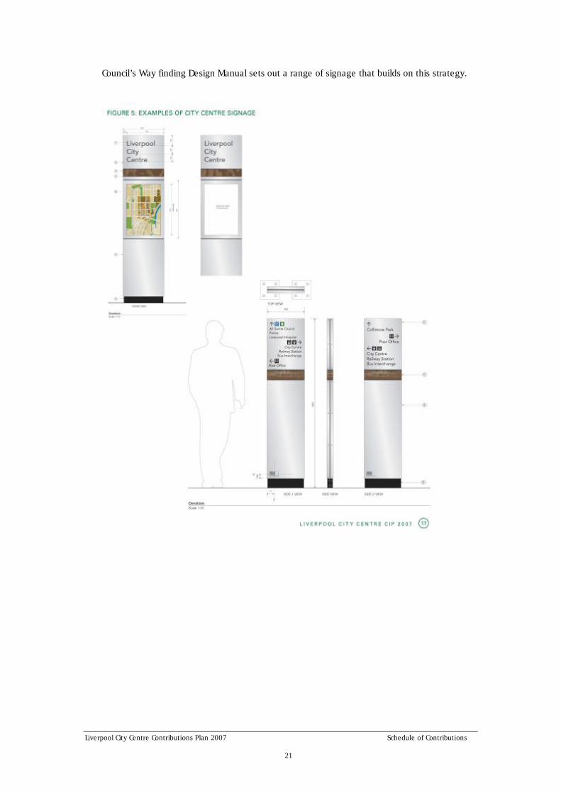
2.10 Signage Strategy
Signage must contribute to the character and amenity of the public domain. Providing a clear and informative system such as that in Figure 5, that reflects the process of access, and the hierarchy of facilities within the city. It is also an essential element in the conservation of energy. The level of signage should be sufficient to address a user’s needs without causing clutter. Principles for establishing a system of signage for different purposes and areas are outlined below:
- cost effectiveness – including recurrent maintenance costs;
- equity of access – provision of accessible signage in public open spaces where possible;
- signage that is multi functional, easy to maintain and is robust;
- visual and environmental appropriateness within the particular context;
- public notice boards as a forum for young people to communicate and promote youth activities;
- contribute to the safety of the city centre;
- create interest and awareness of Liverpool’s natural, cultural and indigenous heritage;
- develop a consistent signage style from frame to graphic;
- develop signage to clip onto light poles to reduce clutter;
- remove unsightly road signage pipe supports in key locations and replace with clip on signage onto light poles; and
- signage should not dominate streets.
Liverpool City Centre Contributions Plan 2007 Schedule of Contributions 21
Council’s Way finding Design Manual sets out a range of signage that builds on this strategy.

Liverpool City Centre Contributions Plan 2007 Schedule of Contributions 22
2.11 City Ecology Strategy
Although the city centre is predominantly a ‘built’ environment, there are opportunities to enhance the natural ecosystem within the centre and beyond. Strategies for enhancing city ecology take advantage of existing resources in the form of waterways, parks and green open spaces to promote a distinctive visual character and satisfy community needs for green breathing spaces.
Strategies for enhancing city ecology include:
- protect and enhance existing reserves, parks, public squares and open spaces in the city centre and at the edges;
- acknowledge and value significant open spaces such as Bigge Park, Pioneer Memorial Park and the Georges River;
- promote positive relationships between the natural systems and the city centre;
- provide positive integration of infrastructure into the public domain;
- carefully select materials in light of sustainable design practices;
- providing pedestrian/cycle connection along waterways – improve water quality and increase biodiversity along the waterways.
The strategy for city ecology is reflected in the special city projects in the Section 3 below

Liverpool City Centre Contributions Plan 2007 Special City Centre Projects 23
3. Special City Centre Projects
The special city centre projects have been identified as essential public infrastructure to support future growth, development and the character of the Liverpool City Centre.
The city projects are major civic facilities to support growth and development in the Liverpool City Centre. These projects are to be funded by S.94A contributions from new development. The special city projects for the city centre are:
- Georges River foreshore improvement and bridge connection;
- Bigge Park landscape upgrade;
- Pioneer Memorial Park embellishment;
- Woodward and Collimore Parks;
- District community facility upgrade;
- Access – car parks with bridge link, intersection upgrade, bus priority;
- Library and Whitlam Centre recoupment; and
- Stormwater management.

Liverpool City Centre Contributions Plan 2007 Special City Centre Projects 24
3.1 Georges River Foreshore Improvement and Bridge Connection
The Georges River is central to the heritage of Liverpool and the waterfront provides an opportunity for embellishment into a major city parkland and recreational corridor. The waterfront upgrade will enhance the recreational opportunities and improve access for pedestrians and cyclists in and around the city centre.
This plan proposes upgrades to the west bank of the Georges River only. The east bank and possible connections across the river will need to be subject to future planning associated with any redevelopment of the land on the east side of the river.
- The planning and design principles for the upgrade to the Georges River waterfront and parkland are:
- appreciation of the natural environment and landscape of the river foreshore;
- opportunities for passive and active recreation and cultural pursuits including amphitheatre and picnic grounds;
- improved amenity, activation and attractiveness of the waterfront including planting groundcover, understorey and canopy;
- provision of an urban riverfront pedestrian and bicycle path and public walkway that provides a link in the regional cycle route between Parramatta and Campbelltown via Georges River and Casula Powerhouse;
- a boardwalk connecting the hospital with the river foreshore providing pedestrian amenity;
- a link from the city centre to the river;
- retention and creation of key natural features including management of bushland, river bank stabilisation, creation of wetlands and management of stormwater;
- retention of flood storage capacity;
- provision of outdoor facilities and furniture to heighten enjoyment of the waterfront;
- promote the natural and heritage features with interpretive facilities;
- access links and paths for a river walk/ cycle track between Light Horse Park, the city centre, TAFE, Hospital and Warwick Farm;
- signage and sense of legibility, safety and security;
- maintenance and reinforcement of view corridors/ visual connections along the foreshore;

Liverpool City Centre Contributions Plan 2007 Special City Centre Projects 25
- incorporation of ESD measures where practical (eg. water sensitive urban design, solar power lights, etc.); and
- retain and rehabilitate riparian corridors and conserve significant environmental values.
The cost of upgrading the west bank of the Georges River parkland is estimated to be $14 million. Further details are in the draft Georges River Corridor Plan of Management and Masterplan prepared by Liverpool City Council.
Bridging the rail line to connect the Georges River and City Centre
Liverpool City Centre is one of three river cities in the metropolitan region and needs connections and links with the Georges River. Connections between the river and city centre will enhance the character and image of Liverpool as a ‘river city’, as well as provide better physical access between the city centre and river foreshore improvements. Access between the city centre and Georges River across the rail line is a core issue in the development of the city centre.
A suitable location for an accessible pedestrian crossing over the railway linking the city centre with the Georges River parkland will be the subject of further investigation and could form part of future development.
3.2 Bigge Park Landscape Upgrade The historic Bigge Park was designated by Governor Macquarie as the city common and used as the original central square of Liverpool. It has a symbolic presence in the Liverpool City Centre and has since developed into Liverpool’s foremost site for memorial and other civic and commemorative celebrations. It is currently listed in the Liverpool LEP as a heritage item and also has a strong relationship as part of the heritage setting for the historic old hospital site on College Street (now the south-western college of TAFE).
The purpose of the landscape improvements is to reinforce the role of Bigge Park as the major symbolic civic open space in the city centre and improve its functionality and amenity for current and future users. The main planning and design principles for the improvements are:
- a park layout that responds to the role of Bigge Park as Liverpool’s major civic park;
- a landscape design that provides an

Liverpool City Centre Contributions Plan 2007 Special City Centre Projects 26
appropriate setting for the surrounding heritage precincts;
- a park with a large open area that can accommodate a wide range of civic and festive events both day and night;
- legible pedestrian and cycle paths that improve access links through the park;
- public art that expresses the heritage, culture and vitality of Liverpool;
- enhancements to the amenity of the park with gardens;
- areas and facilities providing opportunities for various recreational pursuits including children’s play;
- urban furniture for seating, waste management and amenities;
- sense of safety and security with landscaping, lighting and maximising visibility;
- incorporation of water conservation measures and solar lighting where practical; and
- retention of commemorative memorials.
The cost of the proposed improvements to Bigge Park is $3 million.

Liverpool City Centre Contributions Plan 2007 Special City Centre Projects 27
3.3 Pioneer Memorial Park Embellishment
The Liverpool Pioneers’ Memorial Park is located on Crown land dedicated to the care, control and management of Council and which is dedicated as a public park under the Old Liverpool Cemetery Act. It has a high level of local cultural heritage significance as a cemetery between 1821 and 1958 and is listed both on the State Heritage Inventory and as a heritage item in the Liverpool LEP 2008.
The Pioneer Memorial Park is currently underutilised and will be subject to more intensive use and future pressures arising from the growth and development of the city centre. Council has previously prepared a Conservation Management Plan in consultation with the community and a Draft Plan of Management for the Pioneer Memorial Park. A fundamental aspect of the future for this park is its use as a rest park for passive recreation.
The four key objectives for the Park are:
- effectively manage the park;
- protect the cultural heritage;
- reveal the cultural heritage; and
- increase passive recreation opportunities.
Strategies for the future use of the park include:
- a safer environment with landscape measures to protect monuments and give a sense of security;
- implementation of basic conservation and maintenance works;
- development of an interpretation centre with cafe and interpretive signage and facilities, and lighting;
- conservation and return of off-site stored artefacts;
- landscaping to enhance the amenity and aesthetic quality of the park including a memorial garden and screening the impacts of the Hume Highway;
- provision of different areas for passive recreation including larger break-out spaces and smaller intimate spaces that provide a setting for memorials and contemplation;
- legible circulation routes through the park connected to local pedestrian paths and streets providing for a variety of routes;
- provision of furniture and seating for relaxation; and
- return of repaired stored headstones.
The estimated cost of the proposed embellishments to Pioneer Memorial Park is $3 million.

Liverpool City Centre Contributions Plan 2007 Special City Centre Projects 28
3.4 Woodward and Collimore Parks
These parks are on the western periphery of Liverpool City Centre. They provide an opportunity to provide recreation facilities and in particular active recreational opportunities for residents and workers in the city centre that are not be available in the parks within the city centre.
The facilities to be provided at Woodward and Collimore Parks include play equipment, landscaping, fencing / bollards, signage, seating, shade structures, amenities block, spectator seating, basketball court, lighting, pathway network, and bikeway to link all facilities and link to nearby bikeway network.”
Council has also committed funding for environmental rehabilitation works to sections of Brickmakers Creek and Collimore Park.
The cost of the upgraded facilities in Woodward and Collimore Parks is $2 million.
3.5 District Community Facility
District Community Centres have the capacity to accommodate a range of community activities across a number of neighbourhood areas. The multi purpose design of these facilities ensures an efficient use of space. The multi-purpose layout enables a range of functions to be provided simultaneously. This flexibility ensures that the facility has the capacity to easily respond to changing community needs thus ensuring ongoing viability and utilisation. There is need for such space in established residential areas judging by regular requests from community organisations for permanent and sessional office accommodation with associated meeting spaces.
Future residents within the established residential areas will require the provision of appropriate district level community facilities. In order to maximise the use of existing resources it is proposed to upgrade a local community centre to a district level.
The cost in this plan of $425,000 represents the Liverpool City Centre’s share of additional residential development in Liverpool Local Government Area.
3.6 Car Parks, Intersection Upgrades and Bus Priority
The growth and development of the Liverpool City Centre will generate additional traffic and travel demands that need to be accommodated on the local transport systems. The purpose of these transport management measures are to provide for public transport needs and ensure the local road network can accommodate the vehicle traffic. The traffic management measures include:
- a new car park; and
- upgrade of the intersection of Hume Highway and Hoxton Park Road.
Liverpool City Centre Contributions Plan 2007 Special City Centre Projects 29
Transport Management & Accessibility Plan (TMAP)
A Transport Management & Accessibility Plan examines the existing and new developments and the transport facilities and services that new development is likely to require. A TMAP is proposed for Liverpool City Centre area. The TMAP will detail actions needed to ensure that transport abs accessibility are optimised in the Liverpool City Centre.
The TMAP will examine land use and transport issues in terms of both the local and wider area. This is, whilst the TMAP will provide solutions for Liverpool City Centre, it will do so with an understanding of how solutions will fit within the wider regional transport network.
The TMAP will make recommendations about car parking, bus access, road network, cycling and pedestrians.
Bicycle Accessibility
The demand for good bicycle access will increase with the expected employment and residential population growth in Liverpool City Centre. Good bicycle accessibility will assist with the increased use of bicycles as a means of transport. It will help make the best use of the existing street network and parkland to improve accessibility to Liverpool City Centre.
Car parks
Based on current Council projections, there will be a demand for two multi-storey car parks with an estimated cost of $10.5 million. Demand for the multi-storey car parks is based on projections, but depends on the extent to which new commercial development provides parking on site.
One car park is proposed for the west side of Hume Highway to provide car parking in the short term with on-site security and a pedestrian bridge over the Hume Highway. This will start as an at-grade facility on ground level with the flexibility of adding multi-storeys as required. It will be constructed with a bridge link across the Hume Highway which is to cost an additional $1.5 million. The second car park is proposed in the longer term as a multi-storey facility in the southern part of the city centre on or near the ring road.
Upgrade of the intersection of Hume Highway and Hoxton Park Road
Upgrading the intersection of the Hume Highway and Hoxton Park Road to improve access for the city centre is essential to support growth and development in the city centre and in the south-west urban release areas. The upgrade will substantially improve the performance of the road network as well as provide for better access into and out of the Liverpool City Centre and on-site car parking. The upgrade will need to be subject to further detailed planning and costing and consideration will be given to a grade separation. The upgrade of the intersection will not be funded by S.94A contributions under this plan, but by other funding sources.
Bus Priority Access
The expected employment growth in Liverpool City Centre will place increased stress on the existing street system. Congested access to the city centre may hinder its development.
There is a need to minimise the impact of traffic congestion on bus access to the city centre. This will assist in increasing the share of public transport usage well as making the city centre more accessible.
Bus priority measures such as bus priority at traffic signals, exclusive bus lanes and separate bus roads will assist the movement of people in to and out of Liverpool City Centre.
Bus priority measures are estimated to cost $3.8 million.

Liverpool City Centre Contributions Plan 2007 Special City Centre Projects 30
3.7 Existing Library and Whitlam Centre
Central library
Liverpool City Council provides a major library service to the residents and workers in Liverpool City Centre as well as the residents in Liverpool Local Government Area with the central library in Liverpool City Centre. It is the focus of the library service and provides a greater range of services/facilities than the branch libraries. Services provided from the central library not available at branch libraries include major lending collections; extensive reference and specialised information services; specialised programs for elderly, disabled and housebound residents; community language and English as a second language (ESL) materials and activities.
Council undertook an upgrade and extension to the central library to cater for the needs of the anticipated total future population. Council is recouping the costs to Council of upgrading the central library in anticipation of future population growth and the growth of Liverpool City Centre.
The cost of $425,000 in this plan represents the Liverpool City Centre’s share of additional residential development in Liverpool Local Government Area.
Whitlam Centre Extension
The Whitlam Centre is a major indoor recreational facility incorporating a heated pool, gymnasium and multi purpose hall. The centre provides a broad range of recreational opportunities specifically incorporating facilities not generally available at, or of a higher standard / capacity than local recreation centres.
In anticipation of future population growth Liverpool City Council undertook major extensions to the Whitlam Centre in 1994 to 1996. The works undertaken increased the capacity of the centre from a district to citywide facility. The diversity and standard of recreational opportunities of the Whitlam Centre are generally superior to those provided at a local level. The facility services the existing and future residents of Liverpool Local Government Area as well as existing and future workers of Liverpool City Centre.
The contribution levied under this plan seeks to recoup part of the expenditure of Council making allowance for existing and future population likely to be served by the facility excluding non-Liverpool patronage.
The cost of $350,000 in this plan represents the Liverpool City Centre’s share of additional residential development in Liverpool Local Government Area.
3.8 Stormwater Management
Council has a 5 year program for stormwater management projects. Major works are proposed for the south east of the city centre and the northwest of the city centre and an upgrade of trunk drainage at Brickmakers Creek. The cost of these works is estimated at $9,900,000 and will be funded under Council’s capital works program.

Liverpool City Centre Contributions Plan 2007 Section 94A Development Contributions Plan 31
4. Section 94A Development Contributions Plan
4.1 Introduction
This plan is Liverpool Contributions Plan 2007 (Liverpool City Centre) as provided for under Section 94A of the Environmental Planning and Assessment Act, 1979.
Land where Contributions Plan applies:
The Contributions Plan applies to development on land shown in Figure 5.
Figure 5 Land to which this plan applies

Liverpool City Centre Contributions Plan 2007 Section 94A Development Contributions Plan 32
Commencement of Contributions Plan
This plan was adopted by Council on 12 June 2007. The plan originally came into force on 12 December 2007. This was during the September 2007 Quarter. The CPI for this quarter was 158.1. The Contributions Plan applies to development applications determined after the plan came into force.
Relationship to other Plans
The Liverpool Contributions Plan 2007 (Liverpool City Centre) replaces the Liverpool Contributions Plan 2001 where it applies to land within the now superseded Liverpool City Centre Local Environmental Plan.
Development which is subject to the Liverpool Contributions Plan 2007 (Liverpool City Centre) is also subject to Liverpool Local Environmental Plan 2008 and Liverpool Development Control Plan 2008.
Section 94A Levy
Section 94A of the Environmental Planning and Assessment Act, 1979 gives Council the power to impose a levy from developers for public services and public amenities based on a percentage of the cost of the development. Council cannot impose as a condition of the same development consent a condition under this section as well as a condition under section 94.
Money required to be paid by a condition imposed under S94A is to be applied towards the provision, extension or augmentation of public amenities or public services (or towards recouping the cost of their provision, extension or augmentation). The application of the money is subject to any relevant provisions of the contributions plan. A condition imposed under S94A is not invalid by reason only that there is no connection between the development the subject of the development consent and the object of expenditure of any money required to be paid by the condition.
Purpose of Contributions Plan
The primary purposes of this contributions plan are:
- to authorise the imposition of a condition on certain development consents and complying development certificates requiring the payment of a levy pursuant to section 94A of the Environmental Planning and Assessment Act, 1979;
- to assist the Council to provide the appropriate public facilities which are required to maintain and enhance amenity and service delivery within the area; and
- to publicly identify the purposes for which the levies are required.
Pooling of levies
This plan expressly authorises s94A levies paid for different purposes to be pooled and applied (progressively or otherwise) for those purposes. The priorities for the expenditure of the levies are shown in the works schedule. This plan and the works schedule may be reviewed and amended by Council from time to time.
4.2 Payment of Levy
Cost of the levy
This plan authorises Council to grant consent to development to which this plan applies subject to a condition requiring the applicant to pay to the Council a levy in accordance with the following:
- 2% of proposed cost of carrying out development in the R4 High Density Residential and IN2 Light Industrial zones; and

Liverpool City Centre Contributions Plan 2007 Section 94A Development Contributions Plan 33
- 3% of proposed cost of carrying out development in the B1 Neighbourhood Centre, B3 Commercial Core, B4 Mixed Use and B6 Enterprise Corridor zones.
Exemptions to payment of the levy
Development having a value less than $1 million is exempt from the requirement to pay the levy.
Calculation of cost of development
The proposed cost of carrying out the development will be determined in accordance with clause 25J of the Environmental Planning and Assessment Regulation 2000. The procedures set out in Appendix 1 to this plan must be followed to enable Council to determine the amount of the levy to be paid.
The value of the works must be provided by the applicant at the time of the request and must be independently certified by a Quantity Surveyor who is registered with the Australian Institute of Quantity Surveyors or a person who can demonstrate equivalent qualifications.
Without limitation to the above, Council may review the valuation of works and may seek the services of an independent person to verify the costs. In these cases, all costs associated with obtaining such advice will be at the expense of the applicant and no construction certificate will be issued until such time that the levy has been paid.
Indexation of Monetary Contribution
As the date of the consent may vary to the actual time of payment of the contribution, Clause 25(4) of the Environmental Planning and Assessment Regulation 2000 allows Council to adjust the contribution to reflect increased costs between the date of the consent and the time of payment. Contributions required as a condition of consent under the provisions of this plan will be indexed quarterly in accordance with movements in the Consumer Price Index (All Groups Index) for Sydney issued by the Australian Bureau of Statistics.
The following formula for indexing contributions is to be used:
Contribution at time of payment
C2 = C1 x C P I2
C P I1
where: C1 = Monetary contribution imposed on the development consent
C2 = Capital works, administration, professional and legal fees components of the contributions subject of the conditions imposed on the development consent
C P I1 = Latest “Consumer Price Index: All Groups Index Number” for Sydney available from the Australian Bureau of Statistics as at the time of granting the relevant development consent
C P I2 = Latest “Consumer Price Index: All Groups Index Number” for Sydney available from the Australian Bureau of Statistics at time that the contribution is to be paid
Future reviews will not affect any consent granted in accordance with this contributions plan.
Goods and Services Tax
No Goods and Services Tax (GST) is applicable to the payment of contributions made under Section 94A of the Environmental Planning and Assessment Act 1979.

Liverpool City Centre Contributions Plan 2007 Section 94A Development Contributions Plan 34
4.3 Payment Procedures
Timing of payment of the levy
Monetary contributions are required to be paid to Council prior to the issuing of the Construction Certificate, whether by Council or a Private Certifier.
Method of Payment
A monetary contribution is the most common method of payment of a levy. However, Council may consider the provision of works in kind, but only as detailed in the schedule of facilities in this Contributions Plan. If applicable, and only if acceptable to Council, such a transfer or works in kind may be an offset to the monetary contribution otherwise applicable to the development under this plan.
The value of the offset will be as agreed with Council in accordance with the value of the works identified in the Contributions Plan. Applicants will be required to provide details of the works to be undertaken, financial guarantees, bank guarantees and administration.
Construction certificates and the obligation of accredited certifiers
In accordance with Cl146 of the Environmental Planning and Assessment Regulation 2000, a certifying authority must not issue a construction certificate for building work or subdivision work under a development consent unless it has verified that each condition requiring the payment of levies has been satisfied.
In particular, the certifier must ensure that the applicant provides a receipt(s) confirming that levies have been fully paid and copies of such receipts must be included with copies of the certified plans provided to the Council in accordance with Cl142(2) of the of the Environmental Planning and Assessment Regulation 2000. Failure to follow this procedure may render such a certificate invalid. The only exceptions to the requirement are where a works in kind, material public benefit, dedication of land or deferred payment arrangement has been agreed by the Council.
In such cases, Council will issue a letter confirming that an alternative payment method has been agreed with the applicant.
The only exceptions to the requirement are where the Council has agreed a works in kind, material public benefit, dedication of land, or deferred payment arrangement. In such cases, Council will issue a letter confirming that an alternative payment method has been agreed with the applicant.
Deferred Payments
Council will allow payment of contributions to be deferred in the following cases only:
- where the applicant has the intention and ability to provide a material public benefit in part or to full satisfaction of a condition imposed by development consent; or
- in other circumstances, to be outlined in writing by the applicant and determined formally by Council on the merits of the case.
The period of deferral must be for a limited time only as agreed where land is to be dedicated or a material public benefit is to be provided. In merit cases, the period of deferral will be as approved by Council. The period of deferral may be extended subject to providing a renewed bank guarantee, which includes anticipated future interest.
Council will discharge the bank guarantee when payment is made in full by cash payment, land transfer or by completion of works in kind.
Formula for Bank Guarantee Amounts
The following formula to be applied to all bank guarantees for contributions is:
Guarantee Amount = P + P (C1 x Y), where:

Liverpool City Centre Contributions Plan 2007 Section 94A Development Contributions Plan 35
P = Contribution due;
C1 = Compound interest rate comprised of Council’s estimate over the period plus 3 percent (allowance for fluctuations); and
Y = Period of deferral (years).
4.4 Administration of Section 94A Funds
Liverpool City Council is to administer money obtained from the S.94A levy and make decisions on the funding and provision of the special city centre projects in accordance with the Environmental Planning and Assessment Act 1979 and Regulation 2000.
The funds collected under this plan will be pooled for the special city centre projects. These projects are in the Schedule of Works below.
4.5 Expected Development and Demand for Public Facilities
This plan is based on the growth and development projected for the Liverpool City Centre. The projections are for an additional 12,000 residents and 15,000 workers in the city centre by 2031.
The public domain and special city centre projects are identified in the Liverpool City Centre Plan – Civic Improvement Plan as needed to support growth and development in the city centre.
Schedule of works for S94A funding
Project Cost
Georges River foreshore $14,000,000
Bigge Park $3,000,000
Pioneer Park $3,000,000
Woodward and Collimore Parks $2,000,000
District community facility upgrade $425,000
Access – car parks, bridge link, bus priority $15,800,000
Library and Whitlam Centre recoupment $775,000
Total $39,900,000
Other works that may be partially funded by contributions
- Public domain streetscape works
- Stormwater management

Liverpool City Centre Contributions Plan 2007 Appendix 1 36
Appendix 1
Determination of cost of development
Clause 25J of the Regulation sets out how the proposed cost of carrying out development is to be determined.
That clause provides as follows:
25J Section 94A levy—determination of proposed cost of development
1) The proposed cost of carrying out development is to be determined by the consent authority, for the purpose of a section 94A levy, by adding up all the costs and expenses that have been or are to be incurred by the applicant in carrying out the development, including the following:
- if the development involves the erection of a building, or the carrying out of engineering or construction work—the costs of or incidental to erecting the building, or carrying out the work, including the costs (if any) of and incidental to demolition, excavation and site preparation, decontamination or remediation;
- if the development involves a change of use of land—the costs of or incidental to doing anything necessary to enable the use of the land to be changed; and
- if the development involves the subdivision of land—the costs of or incidental to preparing, executing and registering the plan of subdivision and any related covenants, easements or other rights.
2) For the purpose of determining the proposed cost of carrying out development, a consent authority may have regard to an estimate of the proposed cost of carrying out the development prepared by a person, or a person of a class, approved by the consent authority to provide such estimates.
3) The following costs and expenses are not to be included in any estimate or determination of the proposed cost of carrying out development:
- the cost of the land on which the development is to be carried out;
- the costs of any repairs to any building or works on the land that are to be retained in connection with the development;
- the costs associated with marketing or financing the development (including interest on any loans);
- the costs associated with legal work carried out or to be carried out in connection with the development;
- project management costs associated with the development;
- the cost of building insurance in respect of the development;
- the costs of fittings and furnishings, including any refitting or refurbishing, associated with the development (except where the development involves an enlargement, expansion or intensification of a current use of land);
- the costs of commercial stock inventory; and
- any taxes, levies or charges (other than GST) paid or payable in connection with the development by or under any law.