Embed Size (px)
Citation preview
GREEN BEAN DESIGN l a n d s c a p e a r c h I t e c t s PO Box 3178 Austral NSW 2179
Liverpool Range Wind Farm
Proposed view toward Liverpool Range wind farm from the Warung Forest Road
LANDSCAPE & VISUAL IMPACT ASSESSMENT Prepared for:
Prepared by:
GREEN BEAN DESIGN l a n d s c a p e a r c h i t e c t s
March 2014

Liverpool Range Wind Farm Landscape and Visual Impact Assessment V3, March2014
2 GREEN BEAN DESIGN l a n d s c a p e a r c h I t e c t s PO Box 3178 Austral NSW 2179 - Mobile 0430 599 995
Project: Liverpool Range Wind Farm Project Number: 12-162 Report Title: Landscape and Visual Impact Assessment Revision: V3 Author: Andrew Homewood, BSc. (Dual Hons), DipLM, DipHort
Registered Landscape Architect, AILA, MEIANZ Date 13 March 2014 Green Bean Design – Capability Statement Green Bean Design (GBD) is an experienced landscape architectural consultancy specialising in
landscape and visual impact assessment. As an independent consultancy GBD provide professional
advice to a range of commercial and government clients involved in large scale infrastructure project
development.
GBD owner, and Principal Landscape Architect Andrew Homewood, is a Registered Landscape
Architect and member of the Australian Institute of Landscape Architects and the Environmental
Institute of Australia and New Zealand.
Andrew has over 20 years continuous employment in landscape consultancy and has completed
numerous landscape and visual impact assessments for a range of large scale and State significant
infrastructure and renewable energy projects, including wind energy and solar power developments.
GBD has been commissioned for over 20 wind energy projects across New South Wales, Victoria,
South Australia, Queensland and Tasmania, including assessments for:
Silverton Wind Farm Boco Rock Wind Farm Collector Wind Farm
Crookwell 3 Wind Farm Sapphire Wind Farm Willatook Wind Farm
Eden Wind Farm Birrema Wind Farm Rye Park Wind Farm
Paling Yards Wind Farm Port Kembla Wind Farm Bango Wind Farm
Deepwater Wind Farm White Rock Wind Farm Liverpool Range Wind Farm
Conroy’s Gap (Mod 4) Mt Emerald Wind Farm Granville Harbour Wind Farm
GREEN BEAN DESIGN l a n d s c a p e a r c h i t e c t s

Liverpool Range Wind Farm Landscape and Visual Impact Assessment V3, March2014
3 GREEN BEAN DESIGN l a n d s c a p e a r c h I t e c t s PO Box 3178 Austral NSW 2179 - Mobile 0430 599 995
Contents Page Glossary
11
Executive summary 13 Section 1 Introduction 1.1 Introduction 15 1.2 Draft NSW Planning Guidelines Wind Farms
(December 2011) 17
1.3 National Assessment Framework 18
1.4 Auswind Best Practice Guidelines (December 2006) 20
1.5 Methodology 21 1.6 Desktop study 21 1.7 Preparation of ZVI Diagrams 21
1.8 Fieldwork and photography 21 1.9 Assessment of landscape sensitivity 21 1.10 Significance of visual Impact 22 1.11 Photomontages 23 1.12 Shadow flicker & blade glint 23 Section 2 Location 2.1 Location 24 Section 3 Project description 3.1 Project description 26 3.2 Wind turbines 26 3.3 Wind monitoring masts 28 3.4 On-site access tracks 28 3.5 Electrical works 29
Section 4 Local environmental factors 4.1 Climatic and atmospheric conditions 30 4.2 Topography and drainage 30
4.3 Vegetation 31

Liverpool Range Wind Farm Landscape and Visual Impact Assessment V3, March2014
4 GREEN BEAN DESIGN l a n d s c a p e a r c h I t e c t s PO Box 3178 Austral NSW 2179 - Mobile 0430 599 995
Contents Page Section 5
Panorama photographs
5.1 Panorama photographs 32 Section 6 Landscape character areas 6.1 Landscape character areas 33 6.1.1 Upper plateau 34
6.1.2 Plateau spur 34
6.1.3 Slope and hill 34
6.1.4 Cultivated agricultural land 34
6.1.5 Woodland 35
6.1.6 Settlement 35
6.2 Landscape sensitivity assessment 35 6.3 Analysis of landscape sensitivity 38 6.3.1 LCA 1 Upper plateau 39 6.3.2 LCA 2 Plateau spur 40 6.3.3 LCA 3 Slope and hill 41 6.3.4 LCA 4 Cultivated agricultural land 42 6.3.5 LCA 5 Woodland (State Forest) 43
6.3.6 LCA 6 Settlement 44 6.4 Landscape values 45
6.4.1 What are landscape values 45
6.4.2 Historic landscape values 45
6.4.3 Existing landscape values 45
6.5 Summary 46
Section 7 Viewshed, zone of visual influence and visibility 7.1 Introduction 47
7.2 Viewshed 47
7.3 Zone of Visual Influence
48

Liverpool Range Wind Farm Landscape and Visual Impact Assessment V3, March2014
5 GREEN BEAN DESIGN l a n d s c a p e a r c h I t e c t s PO Box 3178 Austral NSW 2179 - Mobile 0430 599 995
Contents Page
7.4 ZVI methodology 48
7.5 ZVI Summary 49 7.6 Visibility 50
7.6.1 Distance effect 50
7.6.2 Movement 51
7.6.3 Relative position 52 Section 8 Significance of visual impact 8.1 Introduction 53 8.2 Residential view location matrix 57 8.3 Summary of residential visual significance (within 2
km of wind turbines) 67
8.4 Summary of residential visual significance (beyond 2
km of wind turbines)
67
8.5 Towns and localities 68
8.5.1 Cassilis 68
8.5.2 Coolah 69
8.6 Future residential dwellings 70
8.7 Local roads 70
8.8 Coolah Tops National Park 71 Section 9
Cumulative assessment
9.1 What is cumulative assessment? 72
9.2 State and regional wind farm developments 72
Section 10 Photomontages 10.1 Photomontages 74
10.2 Photomontages preparation 74
10.3 Photomontages verification 77 Section 11 Night time lighting 11.1 Introduction 78

Liverpool Range Wind Farm Landscape and Visual Impact Assessment V3, March2014
6 GREEN BEAN DESIGN l a n d s c a p e a r c h I t e c t s PO Box 3178 Austral NSW 2179 - Mobile 0430 599 995
Contents Page
11.2 Existing light sources 79 11.3 Potential light sources 79
11.4 Potential view locations and impact 79 Section 12 Electrical works 12.1 Introduction 81
12.2 Substations 82
12.3 330 kV powerline 83
12.4 Visual absorption capability 84
12.5 Assessment of visual significance (electrical infrastructure) 85
12.6 Visual significance matrix (electrical infrastructure) 88
12.7 Summary of visual significance – 330 kV powerline 99
12.7.1 Wind farm site 99
12.7.2 Southern connection (Option 1) 99
12.7.3 Southern connection (Option 2) 99
12.8 Substation locations 100
12.9 The Drip 100
12.10 330 kV powerline photomontage 100
12.11 Cumulative powerline impacts 101
Section 13 Pre construction and construction 13.1 Potential visual impacts 102 Section 14
Perception and public consultation
14.1 Perception 104 14.2 Public Consultation 104 14.3 Quantitative Research 105 14.4 The Broader Public Good 106 Section 15 Mitigation measures 15.1 Mitigation measures 108
Liverpool Range Wind Farm Landscape and Visual Impact Assessment V3, March2014
7 GREEN BEAN DESIGN l a n d s c a p e a r c h I t e c t s PO Box 3178 Austral NSW 2179 - Mobile 0430 599 995
Contents Page 15.1.1 Wind turbine location 108 15.1.2 Wind turbine design and colour 109 15.1.3 Vegetation removal 109 15.1.4 Planting vegetation 109 15.1.5 Night time lighting 110 15.1.6 Electrical wires and power pole design 110 15.2 Broad outline strategy for visual mitigation to residential
dwellings 110
15.3 Summary of potential mitigation options 111 Section 16 Conclusion 16.1 Summary 115
References and Bibliography 118
Limitations 120
Appendix A Draft NSW Planning Guidelines: Wind Farms. Meeting assessment
requirements, Landscape and visual amenity
Appendix B Civil Aviation Safety Authority Advisory Circular AC139-18(0) July 2007 (Withdrawn)
Appendix C Andrew Homewood, curriculum vitae
Liverpool Range Wind Farm Landscape and Visual Impact Assessment V3, March2014
8 GREEN BEAN DESIGN l a n d s c a p e a r c h I t e c t s PO Box 3178 Austral NSW 2179 - Mobile 0430 599 995
Tables
Table 1 Glossary
Table 2 Director Generals Requirements
Table 3 NSW DoP&I Landscape and visual amenity checklist
Table 4 NAF Recommendations
Table 5 Liverpool Range wind turbine details
Table 6 Landscape sensitivity criteria
Table 7 LCA1 – Upper plateau
Table 8 LCA2 – Plateau spur
Table 9 LCA3 – Slope and hill
Table 10 LCA4 – Cultivated agricultural land
Table 11 LCA5 – Woodland (State Forest)
Table 12 LCA6 – Settlement
Table 13 Definitions
Table 14 Distance effect
Table 15 View location sensitivity
Table 16 Numbers of viewers
Table 17 Sensitivity and magnitude assessment criteria
Table 18 Visual significance matrix
Table 19 Residential view location matrix
Table 20 Photomontage details
Table 21 Visual significance matrix (electrical infrastructure)
Table 22 Mitigation measures summary
Table 23 Substation and powerline summary of mitigation measures
Table 24 Key mitigation measures: feasibility, effectiveness, reliability and residual impacts
Liverpool Range Wind Farm Landscape and Visual Impact Assessment V3, March2014
9 GREEN BEAN DESIGN l a n d s c a p e a r c h I t e c t s PO Box 3178 Austral NSW 2179 - Mobile 0430 599 995
Figures Figure 1 Location plan Figure 2 Site layout Figure 3 Proposed powerline Ulan Colliery connection (Option 1 and 2) Figure 4 Visibility and weather Figure 5 Topography Figure 6 Photo locations Figure 7 Photo sheet 1 Figure 8 Photo sheet 2 Figure 9 Photo sheet 3 Figure 10 Landscape Character Areas Figure 11 ZVI visibility zones Figure 12 ZVI Diagram 1 Figure 13 ZVI Diagram 2 Figure 14 ZVI Diagram 3 Figure 15 Distance effect Figure 16 Residential view locations Figure 17 NSW wind farms Figure 18 Photomontages Locations Figure 19 Photomontage L2 Sheet 1 Figure 20 Photomontage L2 Sheet 2 Figure 21 Photomontage L3 Sheet 1 Figure 22 Photomontage L3 Sheet 2 Figure 23 Photomontage L5 Sheet 1 Figure 24 Photomontage L5 Sheet 2 Figure 25 Photomontage L7 Sheet 1 Figure 26 Photomontage L7 Sheet 2 Figure 27 Photomontage L8 Sheet 1 Figure 28 Photomontage L8 Sheet 2

Liverpool Range Wind Farm Landscape and Visual Impact Assessment V3, March2014
10 GREEN BEAN DESIGN l a n d s c a p e a r c h I t e c t s PO Box 3178 Austral NSW 2179 - Mobile 0430 599 995
Figures Figure 29 Photomontage L9 Sheet 1 Figure 30 Photomontage L9 Sheet 2 Figure 31 Photomontage L10 Sheet 1 Figure 32 Photomontage L10 Sheet 2 Figure 33 Photomontage L11 Sheet 1 Figure 34 Photomontage L11 Sheet 2 Figure 35 Photomontage L13 Sheet 1 Figure 36 Photomontage L13 Sheet 2 Figure 37 Photomontage L14 Sheet 1 Figure 38 Photomontage L14 Sheet 2 Figure 39 Photomontage L23 Sheet 1 Figure 40 Photomontage L23 Sheet 2 Figure 41 Photomontage methodology verification Nikon D700 Figure 42 Night lighting at 500 m Figure 43 Night lighting at 3.5 km Figure 44 Night lighting at 17 km Figure 45 Photo sheet 4 Figure 46 Photo sheet 5 Figure 47 Photo sheet 6 Figure 48 Photo sheet 7 Figure 49 Proposed 330 kV powerline route VAC (wind farm site) Figure 50 Option 1 and Option 2 330 kV powerline route - Vegetation Figure 51 Option 1 330 kV powerline route VAC Figure 52 Option 2 330 kV powerline route VAC Figure 53 Proposed powerline photomontage T1 and T2 Figure 54 Proposed powerline photomontage T3 and T4

Liverpool Range Wind Farm Landscape and Visual Impact Assessment V3, March2014
11 GREEN BEAN DESIGN l a n d s c a p e a r c h I t e c t s PO Box 3178 Austral NSW 2179 - Mobile 0430 599 995
Glossary
This LVIA has adopted the following definitions, including those outlined in the Landscape Institute
and Institute of Environmental Management & Assessment, Guidelines for Landscape and Visual
Impact Assessment, Second Edition (2002) and Third Edition (2013).
Table 1 Glossary
Term Meaning
Cumulative effects The summation of effects that result from changes caused by a
development in conjunction with other past, present or reasonably
foreseeable actions.
Cultural significance The aesthetic, historic, scientific, social or spiritual value for past,
present or future generations.
Element (landscape) A component part of the landscape (for example roads, residences,
parks or industrial buildings).
Indirect Impacts Impacts on the environment, which are not a direct result of the
development but are often produced away from it or as a result of a
complex pathway.
Landscape An area, as perceived by people, the character of which is the result of
the action and interaction of natural and/or human factors.
Landcover Combinations of land use and vegetation that cover the land surface.
Landform Combinations of slope and elevation that produce the shape and form
of the land.
Landscape character area These are single unique areas which are the discrete geographical
areas of a particular landscape type.
Landscape feature A prominent eye catching feature, for example a rock outcrop or built
feature.
Landscape and visual
sensitivity
A term applied to specific receptors, combining judgements of the
susceptibility of the receptor to the specific type f change or
development proposed and the value related to that receptor.
Landscape and visual A measure of the importance or gravity of the environmental effect,

Liverpool Range Wind Farm Landscape and Visual Impact Assessment V3, March2014
12 GREEN BEAN DESIGN l a n d s c a p e a r c h I t e c t s PO Box 3178 Austral NSW 2179 - Mobile 0430 599 995
Table 1 Glossary
Term Meaning
significance defined by significance criteria specific to the environmental topic.
Magnitude A combination of the scale, extent and duration of an effect.
Mitigation Measures, including any processes, activity or design to avoid, reduce,
remedy or compensate for adverse landscape and visual effects of a
development project.
Photomontage Computer simulation or other technique to illustrate the appearance
of a development.
Viewshed An area of land surrounding and beyond the project area which may
be potentially affected by the Project.
Visibility A relative determination at which a wind turbine or group of wind
turbines can be clearly discerned and described.
Visual absorption
capability
Classification system used to describe the relative ability of the
landscape to accept modifications and alterations without the loss of
landscape character or deterioration of visual amenity.
Visual amenity The value of a particular area or view in terms of what is seen.
Visual envelope Extent of potential visibility to or from a specific area or feature.
Visual Impact Assessment A process of applied professional and methodical techniques to assess
and determine the extent and nature of change to the composition of
existing views that may result from a development
Visual receptor Individuals and/or defined groups of people who have the potential to
be affected by a proposal.
Zone Visual Influence (ZVI) A theoretical area of landscape from which the Project structures may
be visible.

Liverpool Range Wind Farm Landscape and Visual Impact Assessment V3, March2014
13 GREEN BEAN DESIGN l a n d s c a p e a r c h I t e c t s PO Box 3178 Austral NSW 2179 - Mobile 0430 599 995
Executive summary
Green Bean Design (GBD) was commissioned by Epuron Pty Ltd (the Proponent) to undertake a
Landscape and Visual Impact Assessment (LVIA) for the Liverpool Range wind farm and associated
development infrastructure (the Project).
The Project will have up to 288 wind turbines, and for the purpose of this LVIA, the proposed wind
turbines have been assessed with a maximum blade tip height of 165 m from ground level to tip of
blade and a maximum rotor size of up to 130 m. Associated electrical works include a proposed 330
kV overhead powerline connection across the wind farm site continuing south to a proposed
substation and grid connection at the Ulan colliery.
This LVIA involved desktop studies and site inspections to collect and analyse information to describe
and define the characteristics of the landscape in which the Project will be located. This LVIA has
determined that the landscape surrounding the Project has an overall medium to high sensitivity to
accommodate change, and represents a landscape that is reasonably typical of landscape character
areas that are commonly found in the surrounding areas of the New South Wales Upper Hunter
Renewable Energy Precinct.
As a landscape with an overall medium to high sensitivity to accommodate change, some recognisable
characteristics of the landscape will be altered by the Project and result in the introduction of visually
prominent elements that will alter some perceived landscape characteristics. Alterations to perceived
characteristics may be partially mitigated by existing landscape elements and features within the
landscape. The main characteristics of the landscape, patterns and combinations of landform and
landcover will still be evident.
The Liverpool Range wind farm visibility was determined within the 10 km Project viewshed and
illustrated by panorama photographs and three Zone of Visual Influence (ZVI) diagrams.
The ZVI diagrams demonstrate the influence of topography on visibility and identify areas from which
the wind farm turbines will be visible.
This LVIA assessed the potential visual significance of the Liverpool Range wind farm for involved and
uninvolved residential dwellings within the 10 km viewshed as well as impacts for motorists travelling

Liverpool Range Wind Farm Landscape and Visual Impact Assessment V3, March2014
14 GREEN BEAN DESIGN l a n d s c a p e a r c h I t e c t s PO Box 3178 Austral NSW 2179 - Mobile 0430 599 995
Executive summary
along local roads within and surrounding the Project area. A number of criteria were considered and
assessed to determined levels of visual significance.
One residential dwelling within the Liverpool Range 2 km viewshed has been determined to have low
visual significance. Three residential dwellings within the Liverpool Range 2 km viewshed will have a
low to medium visual significance. Nine residential dwellings have been determined to have a
medium visual significance and nine a medium to high visual significance (all involved residential
dwellings). One involved residential dwelling will have a high visual significance.
This LVIA assessed the potential visual significance associated with the 330 kV powerline routes,
substations and associated electrical infrastructure and determined that the overall visual impact of
these elements is likely to be low due to location relative to existing view locations together with the
screening influence of surrounding topography and vegetation.
A cumulative visual assessment identified one approved wind farm development, the Kyoto wind
farm development, approximately 70 km to the east of the Liverpool Range wind Project. This LVIA
determined that there is unlikely to be any ‘direct’ or ‘indirect’ visibility between the Liverpool Range
wind farm and other approved wind farm developments within the Upper Hunter Renewable Energy
Precinct.
Night time obstacle lighting, if implemented, will have the potential to create a visual impact for
residential view locations surrounding the Liverpool Range wind farm. This LVIA notes that further to
the withdrawal of the CASA Advisory Circular there are no guidelines by which to define criteria for
wind farm night time obstacle lighting.
Although some mitigation measures are considered appropriate to minimise the visual effects for a
number of the elements associated with the wind farm, it is acknowledged that the degree to which
the wind turbines will be visually mitigated is limited at some locations by their scale and position
within the landscape relative to surrounding view locations.

Liverpool Range Wind Farm Landscape and Visual Impact Assessment V3, March2014
15 GREEN BEAN DESIGN l a n d s c a p e a r c h I t e c t s PO Box 3178 Austral NSW 2179 - Mobile 0430 599 995
Introduction Section 1
1.1 Introduction
This LVIA addresses one of the key requirements of the Liverpool Range wind farm Environmental
Assessment (EA) to be submitted and assessed under Part 3A of the Environmental Planning &
Assessment Act 1979 (EP&A Act). This LVIA addresses and responds to the Director General’s
Requirements (DGR’s) dated 31st March February 2011, for the assessment of potential landscape and
visual impacts of the Project. Table 2 outlines the relevant landscape and visual impact assessment
requirements of the DGR’s and the corresponding section in which they are addressed within this
LVIA report.
Table 2 Director General’s Requirements
DGR’s Report Reference
• provide a comprehensive assessment of the landscape character
and values and any scenic or significant vistas of the area
potentially affected by the project, including an assessment of the
significance of landscape values and character in a local and
regional context. This should describe community and stakeholder
values of the local and regional visual amenity and quality, and
perceptions of the project based on surveys and consultation.
Refer LVIA Sections 6 and 14
• assess the impact of shadow “flicker”, blade “glint” and night
lighting from the wind farm.
Refer Liverpool Range wind
farm EA Section 14,
• identify the zone of visual influence including consideration of
night lighting (no less than 10 kilometres) and assess the visual
impact of all project components on this landscape.
Refer LVIA Sections 7 and 11.
• include an assessment of any cumulative visual impacts from
transmission line infrastructure.
Refer LVIA Section 9.
• include photomontages of the project taken from potentially
affected residences (including approved but not yet developed
dwellings or subdivisions with residential rights), settlements and
significant public view points, and provide a clear description of
proposed visual amenity mitigation and management measures
for both the wind farm and the powerline. The photomontages
must include representative views of turbine night lighting if
proposed.
Refer LVIA Sections 10 and 15.
• provide an assessment of the feasibility, effectiveness and
reliability of proposed mitigation measures and any residual
Refer LVIA Section 15.

Liverpool Range Wind Farm Landscape and Visual Impact Assessment V3, March2014
16 GREEN BEAN DESIGN l a n d s c a p e a r c h I t e c t s PO Box 3178 Austral NSW 2179 - Mobile 0430 599 995
Table 2 Director General’s Requirements
DGR’s Report Reference impacts after these measures have been implemented.
The Liverpool Range wind farm will be located across four local government areas:
• Upper Hunter Shire;
• Warrumbungle Shire;
• Liverpool Plains Shire; and
• Mid Western Regional Shire Local Government Areas.
Although not directly applicable to the Liverpool Range EA, GBD has also reviewed the Upper Hunter
Shire Council’s Development Control Plan (DCP) for Wind Power Generation (July 2011) and confirm
that this LVIA addresses a number of key DCP requirements with regard to consideration of visual
assessment.
GBD is cognisant of the Australian Wind Energy Association and Australian Council of National Trust’s
publication Wind Farms and Landscape Values National Assessment Framework, June 2007, and have
encompassed the general assessment framework outlined in the National Assessment Framework
within the LVIA methodology. In addition to the National Assessment Framework, the preparation of
this LVIA has also included a review of the Draft NSW Planning Guidelines Wind Farms (December
2011).
This LVIA involved a comprehensive evaluation of the landscape character in which the Liverpool
Range wind farm and ancillary structures will be located, and an assessment of the potential
landscape and visual impacts that could result from the construction and operation of the wind farm,
taking into account appropriate mitigation measures. This LVIA is based on wind farm technical and
design information provided by the Proponent to GBD.
1.2 Draft NSW Planning Guidelines: Wind Farms (December 2011)
The NSW DoP&I issued the Draft Planning Guidelines: Wind Farms (Draft Guidelines) in December
2011. The Draft Guidelines provide guidance and information for wind farm applicants, consent
authorities as well as communities and stakeholder groups. The Draft Guidelines were placed on
Liverpool Range Wind Farm Landscape and Visual Impact Assessment V3, March2014
17 GREEN BEAN DESIGN l a n d s c a p e a r c h I t e c t s PO Box 3178 Austral NSW 2179 - Mobile 0430 599 995
public exhibition between December 2011 and March 2012; however, had not been finalised or
formally adopted by the New South Wales Government prior to completion of this LVIA.
The Draft Guidelines set out key considerations for the upfront assessment of landscape and visual
impact for residential dwellings within a 2 km radius of proposed wind turbines (through the Gateway
Process and Site Compatibility Certification) and specific assessment requirements that may be set
out in the NSW DoP&I Director General’s Requirements on a project by project basis. The Draft
Guidelines also set out a comprehensive framework for the assessment of landscape and visual
impacts including residential dwellings within 2 km proximity of proposed wind turbines. Landscape
and visual issues are outlined in Appendix A of the Draft Guidelines ‘Meeting assessment
requirements - Landscape and visual amenity’ (Refer Appendix A of this LVIA).
This LVIA has considered and given regard to the Draft Guidelines to the fullest extent practicable,
and addresses the key landscape and visual amenity aspects set out in the NSW DoP&I checklist
issued to the Proponent in the NSW DoP&I correspondence dated 18 April 2012. The key landscape
and visual amenity aspects are set out in Table 3.
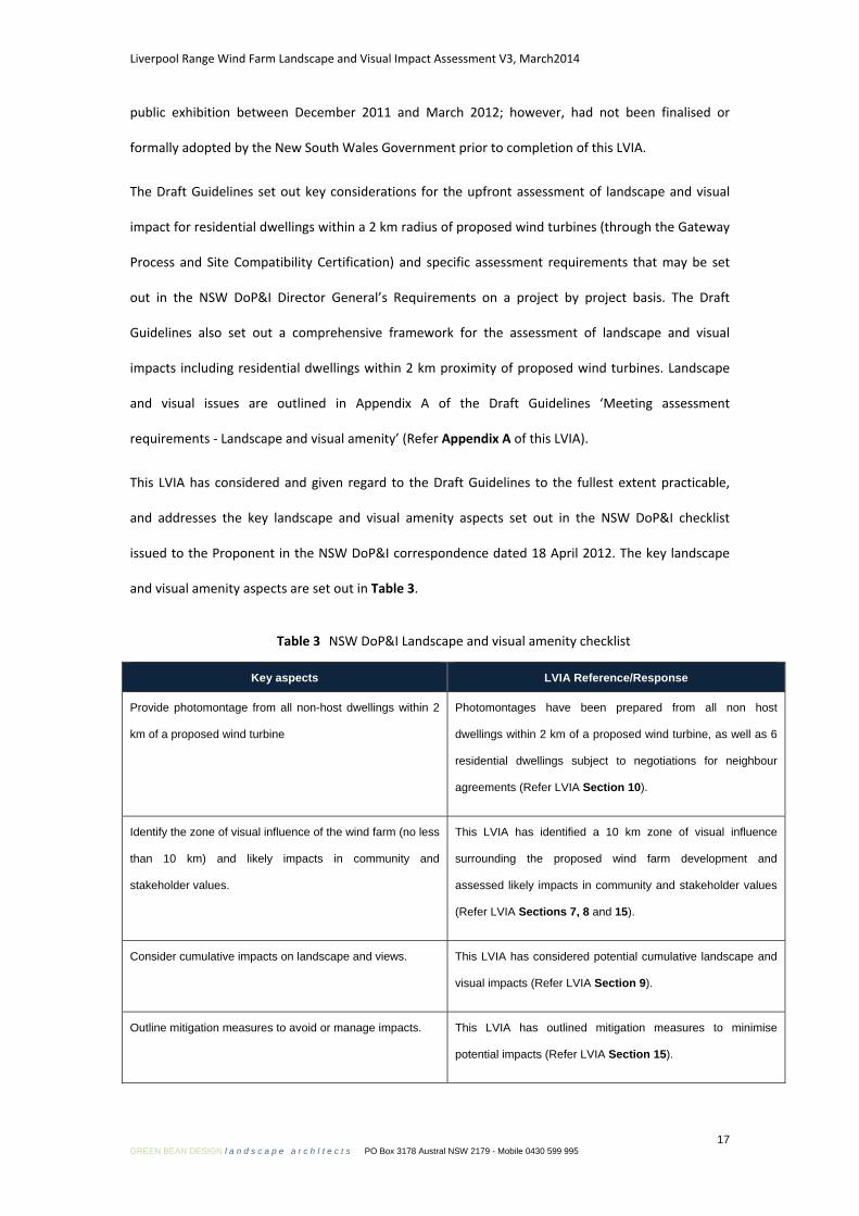
Table 3 NSW DoP&I Landscape and visual amenity checklist
Key aspects LVIA Reference/Response
Provide photomontage from all non-host dwellings within 2
km of a proposed wind turbine
Photomontages have been prepared from all non host
dwellings within 2 km of a proposed wind turbine, as well as 6
residential dwellings subject to negotiations for neighbour
agreements (Refer LVIA Section 10).
Identify the zone of visual influence of the wind farm (no less
than 10 km) and likely impacts in community and
stakeholder values.
This LVIA has identified a 10 km zone of visual influence
surrounding the proposed wind farm development and
assessed likely impacts in community and stakeholder values
(Refer LVIA Sections 7, 8 and 15).
Consider cumulative impacts on landscape and views. This LVIA has considered potential cumulative landscape and
visual impacts (Refer LVIA Section 9).
Outline mitigation measures to avoid or manage impacts. This LVIA has outlined mitigation measures to minimise
potential impacts (Refer LVIA Section 15).

Liverpool Range Wind Farm Landscape and Visual Impact Assessment V3, March2014
18 GREEN BEAN DESIGN l a n d s c a p e a r c h I t e c t s PO Box 3178 Austral NSW 2179 - Mobile 0430 599 995
1.3 National Assessment Framework
GBD is cognisant of the Australian Wind Energy Association and Australian Council of National Trust’s
publication Wind Farms and Landscape Values National Assessment Framework (NAF), June 2007, and
have encompassed the general assessment framework outlined in the NAF within the LVIA
methodology. Table 4 outlines the relevant requirements of the NAF and the corresponding section
in which they are addressed within this LVIA report.
Table 4 NAF Recommendations
NAF Tasks (through Steps 1 to 4) LVIA Reference/Response
Step 1 Assess the Landscape Values
1A Preliminary Landscape Assessment
• 1A.1 Desktop Review
• 1A.2 Seek information from Local Authority
• 1A.3 Identify potential community and stakeholder
interests
• 1A.4 Site survey
• 1A.5 Preliminary assessment of landscape values
1B Full Landscape Assessment
• 1B.1 Define the study area for assessment,
including the zone of visual influence
• 1B.2 Landscape Character Analysis
• 1B.3 Natural and cultural values analysis
• 1B.4 Involve communities and stakeholders in
identifying landscape values
• 1B.5 Document values and analyse significance
This LVIA has been prepared through a comparable
methodology to that outlined in the NAF and has
included a desktop review (pre site inspection) to
determine potential view locations as well as
establishing the extent and types of landscape
characteristics within the 10km viewshed.
Early telephone discussions with the relevant Local
Authorities determined that no additional wind farm
developments were current other than those notified on
the DoP&I website:
(http://majorprojects.planning.nsw.gov.au/page/project-
sectors/transport--communications--energy---
water/generation-of-electricity-or-heat-or-co-generation/)
Community and stakeholder interests have been
identified by an ongoing process of direct consultation
between the Proponent and relevant stakeholders. The
results of the consultative process are included in this
LVIA as well as other relevant sections of the EA.
Site survey and preliminary assessment work has been
undertaken and incorporated into this LVIA. The
preparation of a separate preliminary assessment of
landscape values is not a requirement under the NSW
DoP&I DGR’s.
This LVIA addresses the requirements of Step 1B and
presents an analysis of key considerations included in

Liverpool Range Wind Farm Landscape and Visual Impact Assessment V3, March2014
19 GREEN BEAN DESIGN l a n d s c a p e a r c h I t e c t s PO Box 3178 Austral NSW 2179 - Mobile 0430 599 995
Table 4 NAF Recommendations
NAF Tasks (through Steps 1 to 4) LVIA Reference/Response
the NAF.
Step 2 Describe and Model the Wind Farm in the Landscape
• 2.1 Describe the development
• 2.2 Model the development
• 2.3 Prepare a visual assessment report
This LVIA has described and modelled the Liverpool
Range wind farm development and selected view points
from a range of view locations including uninvolved
residential dwellings and road corridors within the 10km
viewshed.
Step 3 Assess the Impacts of the Wind Farm on Landscape Values
• 3.1 Seek community input to potential impacts
• 3.2 Identify and describe impacts
• 3.3 Identify potential cumulative impacts
• 3.4 Identify other relevant factors
• 3.5 Evaluate impacts
Community and stakeholder interests have been
identified by an ongoing process of direct consultation
between the Proponent and relevant stakeholders. The
results of the consultative process are outlined and
included in this LVIA as well as other relevant sections of
the EA.
This LVIA has identified and described potential
landscape and visual impacts associated with the
Liverpool Range wind farm development as well as
potential cumulative impacts resulting from other wind
farm projects within the Upper Hunter Region
Renewable Energy Precinct.
Step 4 Respond to Impacts
• 4.1 Changes to location or siting of the wind farm
or ancillary infrastructure
• 4.2 Layout and design considerations
• 4.3 Minor changes and mitigation measures
• 4.4 Recommend changes to the development
The development of the Liverpool Range wind farm
turbine layout has been reviewed and adjusted
throughout the preparation of this LVIA. Changes to the
layout have occurred as a result of stakeholder
consultation and specific concerns directed toward the
visual impact of the wind farm from surrounding view
locations.
Significant changes have occurred throughout the
development of the preferred design layouts including
the removal and repositioning of turbines within site
boundary.
The NAF is noted by its authors as a framework document and does not set out a detailed or
prescribed method to undertake an assessment of landscape values. This LVIA has; however, followed

Liverpool Range Wind Farm Landscape and Visual Impact Assessment V3, March2014
20 GREEN BEAN DESIGN l a n d s c a p e a r c h I t e c t s PO Box 3178 Austral NSW 2179 - Mobile 0430 599 995
the majority of techniques and has tested and determined outcomes for the principal issues that have
been raised in the NAF.
1.4 Auswind Best Practice Guidelines (December 2006)
The Auswind Best Practice Guidelines were developed to assist wind farm proponents to implement
best practice in regards to the location and siting of wind energy facilities and to conduct wind farm
investigations and impact assessments. The guidelines have been subject to revisions following
technical reviews and consultation with both industry and broader stakeholder input.
The Guidelines, developed between (the former) Auswind and the National Trust, provide a landscape
assessment approach to describe, assess and evaluate the potential landscape and visual impact of a
proposed wind energy project. A summary of the approach includes:
• consultation with experts in the analysis of the environments visual characteristics e.g.
Landscape Architects;
• preparation of ‘Zone of Visual Influence’ or ‘Seen Area Diagrams’;
• preparation of photomontages (also referred to as Visual Simulations);
• determination of cumulative impact from existing wind energy projects;
• investigation of impacts with associated infrastructure elements, including substation, service
roads and power lines; and
• assessment of Shadow Flicker.
The Auswind Best Practice Guidelines offer best practice advice and are not a mandatory requirement
for wind farm developments within Australia and have been incorporated into this LVIA.
1.5 Methodology
This LVIA methodology included the following activities:
• desktop study addressing visual character and identification of view locations within the
surrounding area;
• fieldwork and photography;
• preparation of ZVI diagrams;
• assessment and determination of landscape sensitivity;

Liverpool Range Wind Farm Landscape and Visual Impact Assessment V3, March2014
21 GREEN BEAN DESIGN l a n d s c a p e a r c h I t e c t s PO Box 3178 Austral NSW 2179 - Mobile 0430 599 995
• assessment of significance of visual impact; and
• preparation of photomontages and illustrative figures.
1.6 Desktop study
A desktop study was carried out to identify an indicative viewshed for the Liverpool Range wind farm.
This was carried out by reference to 1:25,000 scale topographic maps as well as aerial photographs
and satellite images of the Project area and surrounding landscape. A preliminary ZVI diagram was
also produced prior to the commencement of fieldwork in order to inform the likely extent and
nature of areas within the nominated 10km viewshed of the Project.
Topographic maps and aerial photographs were also used to identify the locations and categories of
potential view locations that could be verified during the fieldwork component of the assessment.
The desktop study also outlined the visual character of the surrounding landscape including features
such as landform, elevation, landcover and the distribution of settlements.
1.7 Preparation of ZVI diagrams
The Proponent prepared three ZVI Diagrams to illustrate the potential visibility of the wind turbines
within the Project 10km viewshed. ZVI Diagrams included visibility from tip of blade, hub height and
whole turbine. The ZVI are illustrated in Figures 12, 13, and 14 and detailed in Section 7 of this LVIA.
1.8 Fieldwork and photography
The fieldwork involved:
• three days of site inspections (2nd November 2012, 3rd November 2012 and 4th August 2013) to
determine and confirm the potential extent of visibility of the Project and ancillary structures;
• determination and confirmation of the various view location categories and locations from
which the Project structures could potentially be visible; and
• preparation of a record for each view location inspected and assessed.
1.9 Assessment of landscape sensitivity
The capability of the landscape to accommodate the wind farm will result primarily from the nature
and degree of perceptual factors that can influence interpretation and appreciation of the landscape,
including landform, scale, topographic features, landcover and human influence or modifications.

Liverpool Range Wind Farm Landscape and Visual Impact Assessment V3, March2014
22 GREEN BEAN DESIGN l a n d s c a p e a r c h I t e c t s PO Box 3178 Austral NSW 2179 - Mobile 0430 599 995
1.10 Significance of visual impact
The potential significance for visual impact of the Project on surrounding view locations will result
primarily from a combination of the potential visibility of the wind turbines and the characteristics of
the landscape between, and surrounding, the view locations and the wind farm. The potential degree
of visibility and resultant visual impact will be partly determined by a combination of factors such as:
• category and type of situation from which people could view the wind farm (examples of view
location categories include residents or motorists);
• visual sensitivity of view locations surrounding the wind farm;
• potential number of people with a view toward the proposed wind farm from any one location;
• distance of visual effect (between view locations and the wind farm); and
• duration of time people could view the wind farm from any particular static or dynamic view
location.
An underpinning rationale for this LVIA is that if people are not normally present at a particular
location, such as agricultural areas, or they are screened by landform or vegetation, then there is
likely to be a nil visual impact at that location.
If, on the other hand, a small number of people are present for a short period of time at a particular
location then there is likely to be a low visual impact at that location, and conversely, if a large
number of people are present then the visual impact is likely to be higher.
Although this rationale can be applied at a broad scale, this LVIA also considers, and has determined,
the potential visual impact for individual view locations that will have a higher degree of sensitivity to
the wind farm development, including the potential impact on individual residential dwellings
situated in the surrounding landscape. The determination of a visual impact is also subject to a
number of other factors which are considered in more detail in this LVIA.
Whilst this LVIA addresses a number of static elements associated with the Project, the assessment
acknowledges and has considered the potential visual impact associated with the movement of the
wind turbine rotors.

Liverpool Range Wind Farm Landscape and Visual Impact Assessment V3, March2014
23 GREEN BEAN DESIGN l a n d s c a p e a r c h I t e c t s PO Box 3178 Austral NSW 2179 - Mobile 0430 599 995
1.11 Photomontages
Photomontages have been prepared from eleven view locations to illustrate the potential visibility of
the Liverpool Range wind farm following construction. The photomontages locations included three
uninvolved residential dwellings within 2 km of the Liverpool Range wind turbines, in accordance with
the requirements of the NSW Draft Guidelines.
The uninvolved residential and public photomontage locations were photographed by GBD. The
public photomontage locations were selected to provide representative views from the vicinity of
residential dwellings as well as publically accessible areas and road corridors. The photomontage
locations are illustrated in Figure 18 and the photomontages in Figures 19 to 40. The heights of the
proposed turbines within the photomontages prepared by the Proponent were subject to peer review
and verification by GBD. The photomontage methodology verification is illustrated in Figure 41.
1.12 Shadow flicker & blade glint
The Proponent prepared a shadow flicker assessment and report for the Liverpool Range wind farm.
The results of the shadow flicker assessment are included in Section 14 of the EA.

Liverpool Range Wind Farm Landscape and Visual Impact Assessment V3, March2014
24 GREEN BEAN DESIGN l a n d s c a p e a r c h I t e c t s PO Box 3178 Austral NSW 2179 - Mobile 0430 599 995
Location Section 2
2.1 Location
The Project will be located on the west extent of the Liverpool Range mountain range which runs for
approximately 100 km from the Barrington Tops volcanic plateau to merge with the Warrumbungle
Range west of the Coolah Tops National Park. The location of the Liverpool Range wind farm is
illustrated in Figure 1.
The Project will extend across a series of ridgelines running in an approximate north to south
alignment from the Liverpool Range. The Project area will incorporate around 21 participating rural
residential and farming properties covering an area around 50,900 hectares across portions of the:
• Upper Hunter Shire;
• Warrumbungle Shire;
• Liverpool Plains Shire; and
• Mid Western Regional Shire.
Small towns and localities within and beyond the 10 km viewshed include:
• Coolah (approximately 6.5 km to the south west). Population 798;
• Cassilis (approximately 4.2 km to the south east). Population 350;
• Dunedoo - (approximately 42 km to the south west). Population 836;
• Gulgong (approximately 56 km to the south west). Population 1,866; and
• Merriwa (approximately 40 km to the south east). Population 973.
Population figures from the Australian Bureau of Statistics 2011 Census.
The Coolah Tops National Park and a small number of State Forests are located within the vicinity of
the Project. The Coolah Tops National Park adjoins the north portion of the Project site boundary.
Covering an area of approximately 12,000 hectares, the Park is noted as a prominent landscape
feature in the region, and forms a contrasting backdrop to surrounding farmland. The northern edge
of the Park provides a number of lookout locations which provide panorama views to the north of the
Park. There are no designated lookouts along the south edge of the Park overlooking the wind farm
site. The Park offers a small number of low key visitor opportunities such as:

MUSWELLBROOK
ABERDEEN
SCONE
QUIRINDI
MERRIWA
CASSILIS
COOLAH
GULGONG
MURRURUNDICOOLAH TOPSNATIONAL PARK
GOULBURN RIVERNATIONAL PARK
GOULBURN RIVERNATIONAL PARK
LIVERPOOL RANGEWIND FARMINDICATIVE EXTENT
ULANCOLLIERY
SydneyLiverpool Rangewind farm
NSW
VIC
SA
QLD
Canberra
LIVERPOOL RANGE WIND FARM -LOCATION PLAN, STATE CONTEXT (Not to scale)
Sou
rce:
Cop
yrig
ht C
omm
onw
ealth
of A
ustra
lia (G
eosc
ienc
e A
ustra
lia) 2
012
http
://m
apco
nnec
t.ga.
gov.
au/M
apC
onne
ct/2
50K
/
LIVERPOOL RANGE WIND FARM -LOCATION PLAN, REGIONAL CONTEXT (Not to scale)
Figure 1Location Plan
LIVERPOOL RANGE WIND FARMLiverpool Range Wind Farm Pty Ltd

Liverpool Range Wind Farm Landscape and Visual Impact Assessment V3, March2014
25 GREEN BEAN DESIGN l a n d s c a p e a r c h I t e c t s PO Box 3178 Austral NSW 2179 - Mobile 0430 599 995
• Camping;
• Day use areas (for picnics);
• Walking or cycling; and
• Horse riding.
The NSW National Parks and Wildlife Service note that the Park is isolated and unlikely to ever receive
very high visitor numbers. The location of the Park, and the key camping and day use areas are
illustrated in Figure 49.

Liverpool Range Wind Farm Landscape and Visual Impact Assessment V3, March2014
26 GREEN BEAN DESIGN l a n d s c a p e a r c h I t e c t s PO Box 3178 Austral NSW 2179 - Mobile 0430 599 995
Project description Section 3
3.1 Project description
The key visual components of the Project will comprise:
• up to 288 wind turbines;
• up to 288 individual 33kV external kiosk transformers and switchgear with associated control
systems to be located in the vicinity of the wind turbine towers (in some turbine models
transformer equipment will be integrated within the tower or nacelle);
• underground and overhead electrical and communication cable network linking turbines to each
other within the Project boundary;
• up to six new 22 or 33/330 kV collection substations and one connection substation located
across the wind farm and at the Ulan colliery site respectively;
• a new overhead powerline rated at up to 330 kV (nominal) capacity. The new powerline will be
mounted on a single pole type structure and may be single-circuit or double-circuit as required;
• up to 10 permanent wind monitoring masts. The permanent monitoring masts may be either
static guyed or un-guyed structures and will be to a minimum height of the wind turbine hubs;
• on site access tracks for construction, operation and ongoing maintenance; and
• wind farm signage and maintenance facilities.
Temporary works associated with the construction of the wind farm that may be visible during
construction and operational phases include:
• construction compounds;
• laydown and storage areas;
• crane hardstand areas; and
• mobile concrete batching plant and rock crushing facilities.
3.2 Wind turbines
The specific elements of the wind turbines comprise:
• concrete foundations;
• tubular tapering steel or concrete towers;

Liverpool Range Wind Farm Landscape and Visual Impact Assessment V3, March2014
27 GREEN BEAN DESIGN l a n d s c a p e a r c h I t e c t s PO Box 3178 Austral NSW 2179 - Mobile 0430 599 995
• nacelles at the top of the tower housing the gearbox and electrical generator;
• rotors comprising a hub (attached to the nacelle) with three blades; and
• three fibreglass / carbon fibre blades attached to each hub.
The following diagram identifies the main components of a typical wind turbine:
Configuration and components
of a typical wind turbine
Table 5 outlines the main design parameters for the proposed Liverpool Range wind turbine layout:
Table 5 Liverpool Range wind turbine details:
Element
Description
Tower height 100 m
Rotor Diameter 130 m
Overall height from ground level to tip of blade 165 m
Proposed number of Liverpool Range wind turbines 288 turbines
As new turbines come onto the market, it is possible that the final turbine selected may exceed, in
minor respects, the assessed maximum turbine envelope. Minor increases in envelope size are
unlikely to alter the determination of visual significance for residential view locations included in this
LVIA. The indicative Liverpool Range wind farm design layout is illustrated in Figure 2. The proposed
330 kV powerline route options to the Ulan colliery are illustrated in Figure 3.

2km
5km
10km
2km
5km
10km
Goulburn RiverNational Park
Proposed Liverpool Range wind turbine(indicative layout)
Distance from proposed LiverpoolRange wind turbine
Proposed 330 kV powerline route
National Park
Proposed substation locationunder investigation
Option 1 330 kV powerline route(connection south to Ulan)
Option 2 330 kV powerline route(connection south to Ulan)
State Forest
Figure 2Site layout
Liverpool Range Wind Farm Pty Ltd
LIVERPOOL RANGE WIND FARM
Legend
0km 10km
Sou
rce:
Cop
yrig
ht C
omm
onw
ealth
of A
ustra
lia (G
eosc
ienc
e A
ustra
lia) 2
012
http
://m
apco
nnec
t.ga.
gov.
au/M
apC
onne
ct/2
50K
/

Ulan mine P20
P10
P11
P12
P13
P14P15
P16
P17
P18
P21
T1
T2
T4
Option 1 330 kV powerline route(connection south to Ulan)
Option 2 330 kV powerline route(connection south to Ulan)
Potentially involved residential dwelling(indicative location)
Potential substation location
Residential dwelling (indicative location)
Photo location (refer photo sheets 4 to 7)
Powerline photomotage location (referFigures 53 and 54)
Figure 3Proposed powerline UlanColliery connection(Option 1 and 2)
LIVERPOOL RANGE WIND FARMLiverpool Range Wind Farm Pty Ltd
Legend
Sou
rce:
Cop
yrig
ht C
omm
onw
ealth
of A
ustra
lia (G
eosc
ienc
e A
ustra
lia) 2
012
http
://m
apco
nnec
t.ga.
gov.
au/M
apC
onne
ct/2
50K
/
Liverpool Range Wind Farm Landscape and Visual Impact Assessment V3, March2014
28 GREEN BEAN DESIGN l a n d s c a p e a r c h I t e c t s PO Box 3178 Austral NSW 2179 - Mobile 0430 599 995
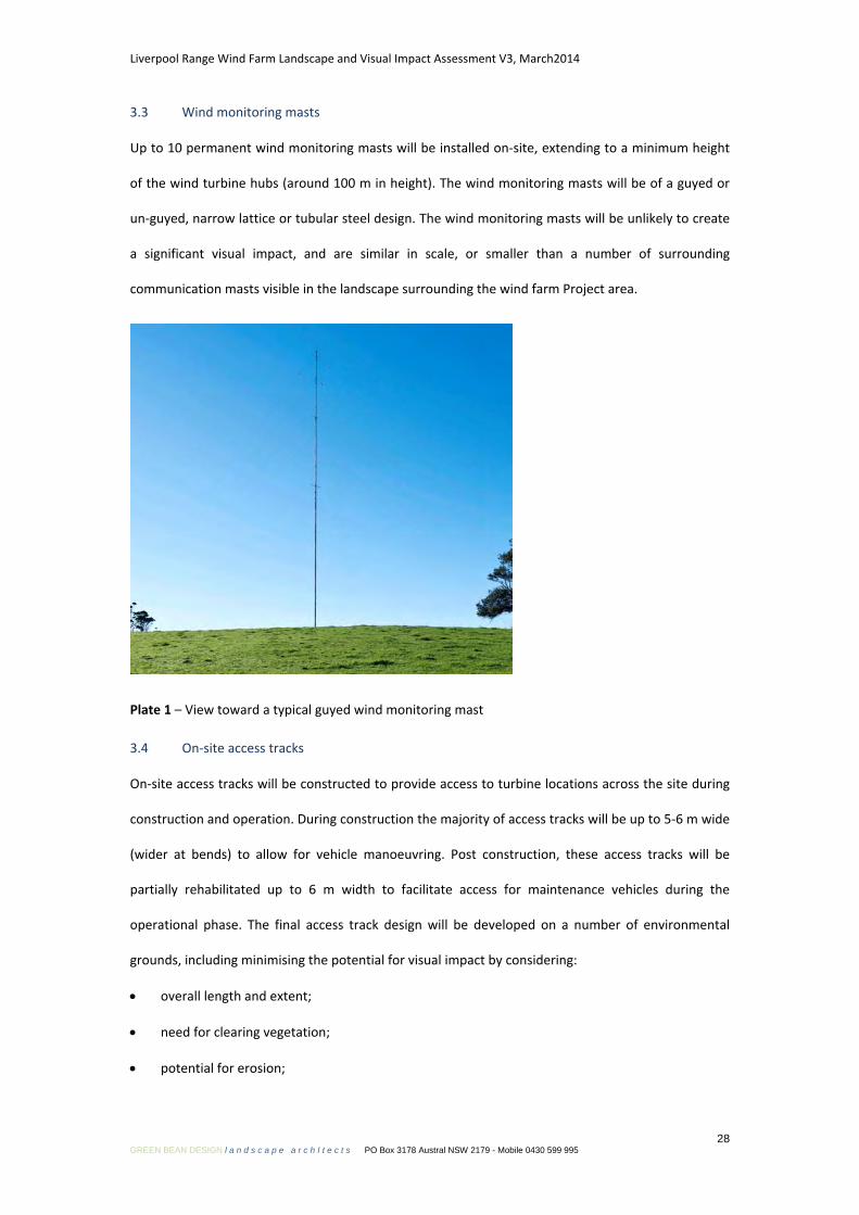
3.3 Wind monitoring masts
Up to 10 permanent wind monitoring masts will be installed on-site, extending to a minimum height
of the wind turbine hubs (around 100 m in height). The wind monitoring masts will be of a guyed or
un-guyed, narrow lattice or tubular steel design. The wind monitoring masts will be unlikely to create
a significant visual impact, and are similar in scale, or smaller than a number of surrounding
communication masts visible in the landscape surrounding the wind farm Project area.
Plate 1 – View toward a typical guyed wind monitoring mast
3.4 On-site access tracks
On-site access tracks will be constructed to provide access to turbine locations across the site during
construction and operation. During construction the majority of access tracks will be up to 5-6 m wide
(wider at bends) to allow for vehicle manoeuvring. Post construction, these access tracks will be
partially rehabilitated up to 6 m width to facilitate access for maintenance vehicles during the
operational phase. The final access track design will be developed on a number of environmental
grounds, including minimising the potential for visual impact by considering:
• overall length and extent;
• need for clearing vegetation;
• potential for erosion;

Liverpool Range Wind Farm Landscape and Visual Impact Assessment V3, March2014
29 GREEN BEAN DESIGN l a n d s c a p e a r c h I t e c t s PO Box 3178 Austral NSW 2179 - Mobile 0430 599 995
• extent of cut and fill; and
• potential to maximise rehabilitation at the completion of the construction phase.
3.5 Electrical works
The majority of cabling works, including the installation of control cables linking the turbines to the
control building will be installed underground. For various technical, commercial and landform
reasons some cabling may be required to be installed on medium voltage overhead powerline
supported by single low profile tubular poles.
Grid connection will be achieved via a connection to the existing TransGrid 330 kV powerline which is
located at the Ulan colliery, approximately 35 km south of the wind farm site. The wind farm turbines
will be connected to on-site collection substations, control room and facilities for the grid connection.
The proposed electrical works are described in Section 12.

Liverpool Range Wind Farm Landscape and Visual Impact Assessment V3, March2014
30 GREEN BEAN DESIGN l a n d s c a p e a r c h I t e c t s PO Box 3178 Austral NSW 2179 - Mobile 0430 599 995
Local environmental factors Section 4
4.1 Climatic and atmospheric conditions
Local climatic and atmospheric conditions have the potential to influence the visibility of the Project
from surrounding view locations, and more significantly, from distant view locations. Meteorological
data collected over the past 100 years at Dunedoo (Post Office) indicates that there are:
• 101 clear days (annual mean average);
• 94 cloudy days (annual mean average); and
• 63 days of rain (annual mean average).
Rainfall will tend to reduce the level of visibility from a number of view locations surrounding the
Project with the degree of visibility tending to decrease over distance. Rain periods will be likely to
reduce the number of visitors travelling through the areas from which the Project could be visible,
and potentially decrease the duration of time spent at a particular public view location with a view
toward the Project.
Cloud cover will also tend to reduce the level of visibility of the Project and lessen the degree of
contrast between the wind turbine structures and the background against which the wind turbines
will be visible.
On clear or partly cloudy days, the position of the sun will also have an impact on the degree of
visibility of the Project. The degree of impact will be largely dependent on the relationship between
the position and angle of the sun relative to the view location. Late afternoon and early evening views
toward the west will result in the wind turbines silhouetted above the horizon line, and with
increasing distance will tend to reduce the contrast between the wind turbine structures and the
surrounding landform.
The extent to which weather conditions can influence visibility toward turbine structures is illustrated
in Figure 4.
4.2 Topography and drainage
The landform of the wind farm site falls gently from the north to the south across a series of
ridgelines sloping from the Liverpool Range mountain range toward the localities of Coolah and

PHOTOGRAPH A - Day time view from Hume highway toward Cullerin wind farm at around 3.5km (13th June 2010)
PHOTOGRAPH B - Day time view from Hume highway toward Cullerin wind farm at around 3.5km (10th June 2010)
PHOTOGRAPH C - Day time view from Hume highway toward Cullerin wind farm at around 3.5km (7th July 2010)
PHOTOGRAPH AIllustrates the visibility of wind turbinesagainst a clear and blue sky backdrop with sunlightfrom above and to the right of the wind turbinescreating a shadow line along the left hand side ofthe towers as well as portions of the rotor blades.
PHOTOGRAPH BIllustrates the visibility of wind turbines against apartly cloudy and overcast backdrop. The windturbines in cloud shadow appear off white togrey in colour.
PHOTOGRAPH C -Illustrates the visibility of wind turbinesin fog/low cloud cover.
Figure 4Visibility and weather
LIVERPOOL RANGE WIND FARMLiverpool Range Wind Farm Pty Ltd
Liverpool Range Wind Farm Landscape and Visual Impact Assessment V3, March2014
31 GREEN BEAN DESIGN l a n d s c a p e a r c h I t e c t s PO Box 3178 Austral NSW 2179 - Mobile 0430 599 995
Cassilis. A number of ephemeral drainage lines occur across the Project site, draining to broader
valleys west and east of the wind farm site. Landform and elevation within and surrounding the
Project site are illustrated in Figure 5.
4.3 Vegetation
A detailed survey of existing vegetation has been carried out as part of the biodiversity assessment for
the Project EA and is summarised in the Section 11 of the EA.
In general the landscape within the Project site contains vegetation associated with woodland,
drainage lines, small ponds/dams and cleared land for pasture and agricultural crop cultivation.
Stands of remnant woodland occur within the wider context of a modified landscape which continues
to be managed through a variety of farming activities.
Timbered areas have some potential to provide partial or full screening toward the Project area from
surrounding public and residential view locations. The screening potential tends to increase when
combined with the local topography of hills and undulating landform.
The landscape within and surrounding the Project site is illustrated in the panorama photographs
presented in Figures 7, 8 to 9.

2km
5km
10km
2km
5km
10kmDistance from proposed LiverpoolRange wind turbine
Proposed 330 kV powerline routewithin project area
Option 1 330 kV powerline route(project area to Ulan substation)
Proposed Liverpool Range wind turbine
Option 2 330 kV powerline route(project area to Ulan substation)
1,240
1,1371,034
931
828
725622
519
Figure 5Topography
Liverpool Range Wind Farm Pty Ltd
LIVERPOOL RANGE WIND FARM
Legend
0km 10km
Elevation (meters)

Liverpool Range Wind Farm Landscape and Visual Impact Assessment V3, March2014
32 GREEN BEAN DESIGN l a n d s c a p e a r c h I t e c t s PO Box 3178 Austral NSW 2179 - Mobile 0430 599 995
Panorama photographs Section 5
5.1 Panorama Photographs
A series of digital photographs were taken during the course of the fieldwork to illustrate existing
views in the vicinity of a number of view locations inspected and assessed as part of this LVIA.
Individual photographs were digitally stitched together to form a segmented panorama image to
provide a visual illustration of the existing view from each photo location.
The panorama photographs presented in this LVIA have been annotated to identify key features or
structures located within the existing view. They also indicatively illustrate the general extent and
location of potentially visible wind turbines or portions of turbine structures for the Project.
The panorama photograph locations are illustrated in Figure 6, and the panorama photographs
illustrated in Figures 7, 8 to 9. The panorama photographs are not to be confused with the
photomontages. The panorama photographs do not include a representation or model of the wind
turbine structures. The photomontages are discussed in Section 10 of this LVIA, and are illustrated in
Figures 19 to 40.

2km
5km
10km
2km
5km
10km
P1
P2P4
P3P5
P6
P7
P8P9
P19
Proposed Liverpool Range wind turbine(indicative layout)
Distance from proposed LiverpoolRange wind turbine
Proposed 330 kV powerline route
Coolah Tops National Park
Panorama photo location
Option 1 330 kV powerline route(connection south to Ulan)
Option 2 330 kV powerline route(connection south to Ulan)
Powerline panorama photo location(refer photo sheet 7)
Figure 6Photo locations
Liverpool Range Wind Farm Pty Ltd
LIVERPOOL RANGE WIND FARM
Legend
0km 10km
Sou
rce:
Cop
yrig
ht C
omm
onw
ealth
of A
ustra
lia (G
eosc
ienc
e A
ustra
lia) 2
012
http
://m
apco
nnec
t.ga.
gov.
au/M
apC
onne
ct/2
50K
/

Photo Location P1- View north east to north west from Rotherwood Road (Approximate distance to closest wind turbine 3 km)
Photo Location P2 - View north west to north from Rotherwood Road (Approximate distance to closest wind turbine 4 km)
Photo Location P3 - View west to north west from Rotherwood Road (Approximate distance to closest wind turbine 2 km)
Long distance views toward proposed Liverpool Range wind turbines
(Imag
e so
urce
Epu
ron
2012
)
Long distance views toward proposed Liverpool Range wind turbines
Rotherwood Road
Short distance views toward proposed Liverpool Range wind turbines
Rotherwood Road
(Imag
e so
urce
Epu
ron
2012
)(Im
age
sour
ce E
puro
n 20
12)
Rotherwood Road
Individual photographs taken with a Nikon D90camera with a 50 mm prime lens. Thiscombination of camera and lens results in aphotograph equivalent to a 35mm single lensreflex camera with a 75 mm lens.
Composite digital stitching results in apanorama with an approximate view anglebetween 110° and 130°.
Extent of potential wind turbine visibility andillustrated on each panorama photograph isindicative only.
Notes
Figure 7Photo Sheet 1
Liverpool Range Wind Farm Pty Ltd
LIVERPOOL RANGE WIND FARM

Photo Location P4 - View north from Turee Vale and Cassilis Road intersection (Approximate distance to closest wind turbine 4 km)
Photo Location P5 - View north east to east from Turee Vale Road (Approximate distance to closest wind turbine 2 km)
Photo Location P6 - View north east to east from Cassilis Road, Coolah (Approximate distance to closest wind turbine 6 km)
Long distance views toward proposed Liverpool Range wind turbines
(Imag
e so
urce
Epu
ron
2012
)
Short distance views toward proposed Liverpool Range wind turbines
Turee Vale Road
Long distance views toward proposed Liverpool Range wind turbines
Cassilis Road
(Imag
e so
urce
Epu
ron
2012
)(Im
age
sour
ce E
puro
n 20
12)
Turee Vale Road
Figure 8Photo Sheet 2
Liverpool Range Wind Farm Pty Ltd
LIVERPOOL RANGE WIND FARM
Individual photographs taken with a Nikon D90camera with a 50 mm prime lens. Thiscombination of camera and lens results in aphotograph equivalent to a 35mm single lensreflex camera with a 75 mm lens.
Composite digital stitching results in apanorama with an approximate view anglebetween 110° and 130°.
Extent of potential wind turbine visibility andillustrated on each panorama photograph isindicative only.
Notes

Photo Location P7 - View north east from Mauualey-Coolah and Gundaree Road intersection (Approximate distance to closest wind turbine 6.5 km)
Photo Location P8 - View north east to east from Gundaree Road (Approximate distance to closest wind turbine 4.3 km)
Photo Location P9 - View north from the Warung State Forest Road (Approximate distance to closest wind turbine 2 km)
Long distance views toward proposed Liverpool Range wind turbines
(Imag
e so
urce
Epu
ron
2012
)
Long distance views toward proposed Liverpool Range wind turbines
Gundaree Road
Short distance views toward proposed Liverpool Range wind turbines
Warung State Forest Road
(Imag
e so
urce
Epu
ron
2012
)(Im
age
sour
ce E
puro
n 20
12)
Gundaree Road
Figure 9Photo Sheet 3
Liverpool Range Wind Farm Pty Ltd
LIVERPOOL RANGE WIND FARM
Individual photographs taken with a Nikon D90camera with a 50 mm prime lens. Thiscombination of camera and lens results in aphotograph equivalent to a 35mm single lensreflex camera with a 75 mm lens.
Composite digital stitching results in apanorama with an approximate view anglebetween 110° and 130°.
Extent of potential wind turbine visibility andillustrated on each panorama photograph isindicative only.
Notes

Liverpool Range Wind Farm Landscape and Visual Impact Assessment V3, March2014
33 GREEN BEAN DESIGN l a n d s c a p e a r c h I t e c t s PO Box 3178 Austral NSW 2179 - Mobile 0430 599 995
Landscape character areas Section 6
6.1 Landscape character areas
A fundamental part of this LVIA is to understand and describe the nature and sensitivity of different
components of the landscape within the Project 10 km viewshed, and to assess the landscape
character in a clear and consistent process. For the purpose of this LVIA, landscape character is
defined as ‘the distinct and recognisable pattern of elements that occur consistently in a particular
type of landscape’ (The Countryside Agency and Scottish Natural Heritage 2002).
This LVIA has identified six Landscape Character Areas (LCA’s), which occur within the Project 10 km
viewshed. The six LCA’s represent areas that are relatively consistent and recognisable in terms of
their key visual elements and physical attributes; which include a combination of
topography/landform, vegetation/landcover, land use and built structures (including settlements and
local road corridors).
The six LCA’s have been identified through a desk top assessment and described during the landscape
assessment fieldwork (carried out over three days) for the Liverpool Range wind farm LVIA. The six
LCA have been determined and illustrated in Figure 10. The LCA’s are not considered to be discrete
areas, and characteristics within one LCA may occur within adjoining or surrounding LCA’s. For the
purpose of this LVIA the six LCA are:
• LCA 1 – Upper plateau (forested);
• LCA 2 – Plateau spur (ridge and gully complex);
• LCA 3 – Slope and hill;
• LCA 4 – Cultivated agricultural land;
• LCA 5 – Woodland; and
• LCA 6 – Settlement.
An overview of each LCA is presented below, with further description and assessment provided in
Tables 7 to 12.

10km
10km
LCA 1
LCA 2
LCA 2
LCA 3
LCA 3
LCA 4
LCA 4
LCA 4
LCA 4
LCA 5
LCA 4
LCA 4
Cassilis 10km
10km
Proposed Liverpool Range wind turbine(indicative layout)
Distance from proposed LiverpoolRange wind turbine
Proposed 330 kV powerline route
Coolah Tops National Park
Proposed substation locationunder investigation
Option 1 330 kV powerline route(connection south to Ulan)
Option 2 330 kV powerline route(connection south to Ulan)
LCA 1 - Upper plateau (forested)
LCA 2 - Plateau spur(ridge and gully complex)
LCA 3 - Slopes and hills
LCA 4 - Cultivated agricultural land
LCA 5 - Woodland
LCA 6 - Settlement
Figure 10Landscape Character Areas
Liverpool Range Wind Farm Pty Ltd
LIVERPOOL RANGE WIND FARM
Legend
0km 10km
Sou
rce:
Cop
yrig
ht G
oolg
e E
arth
Pro
201
3, C
nes
Spo
t Im
age,
Dig
ital G
lobe
2013

Liverpool Range Wind Farm Landscape and Visual Impact Assessment V3, March2014
34 GREEN BEAN DESIGN l a n d s c a p e a r c h I t e c t s PO Box 3178 Austral NSW 2179 - Mobile 0430 599 995
6.1.1 Upper plateau (forested)
The upper plateau LCA is located in the north-west portion of the 10 km viewshed and incorporates a
moderate to densely forested plateau that extends across the western section of the Coolah Tops
National Park.
The physical attributes and landscape sensitivity of the upper plateau LCA are described and assessed
in Table 7.
6.1.2 Plateau spur (ridge and gully complex)
The plateau spur LCA comprises a series of complex ridges and gullies that occur in a west to south
west and south direction from the narrow plateau above. The plateau spur is located in the north
west to south east portion of the 10 km viewshed. The gullies are moderate to deep incised features
which form a large number of ephemeral drainage lines flowing toward creeks within narrow valleys
between ridgelines. The plateau spur incorporates moderate to dense stands of tree cover on steeper
side slopes and alongside riparian areas.
The physical attributes and landscape sensitivity of the plateau spur LCA are described and assessed
in Table 8.
6.1.3 Slope and hill
The slopes and hills LCA comprises low rolling hills, ridgelines and broad valleys below areas of
steeper topography within the plateau spur LCA. The slopes and hills LCA extends through the central
and south to south west portion of the 10 km viewshed. The slopes and hills incorporate small areas
of dense timber stands as well as broader areas of scattered tree cover.
The physical attributes and landscape sensitivity of the slopes and hills LCA are described and
assessed in Table 9.
6.1.4 Cultivated agricultural land
The cultivated agricultural land LCA comprises gently sloping to relatively level areas of land within
the north portion of the 10 km viewshed and isolated valley bottoms between slopes and hills in the
west and southern portion of the viewshed.

Liverpool Range Wind Farm Landscape and Visual Impact Assessment V3, March2014
35 GREEN BEAN DESIGN l a n d s c a p e a r c h I t e c t s PO Box 3178 Austral NSW 2179 - Mobile 0430 599 995
The physical attributes and landscape sensitivity of the cultivated agricultural land LCA are described
and assessed in Table 10.
6.1.5 Woodland (State Forest)
The woodland (State Forest) LCA comprises gently sloping and undulating areas of land within the
south portion of the 10 km viewshed. The LCA generally encompasses the Turill State Forest which is a
moderate to densely timbered area north of the Golden Highway.
The physical attributes and landscape sensitivity of the woodland (State Forest) LCA are described and
assessed in Table 11.
6.1.6 Settlement (Coolah and Cassilis)
The settlement LCA comprises the Coolah township and Cassilis village. Coolah is located within the
western portion of the 10 km viewshed and Cassilis within the south.
The physical attributes and landscape sensitivity of the settlement LCA are described and assessed in
Table 12.
6.2 Landscape sensitivity assessment
The British Landscape Institute describes landscape sensitivity as ‘the degree to which a particular LCA
can accommodate change arising from a particular development, without detrimental effects on its
character’.
The assessment of landscape sensitivity is based upon an evaluation of the physical attributes
identified within each LCA, both singularly and as a combination that gives rise to the landscape’s
overall robustness and the extent to which it could accommodate the wind farm development. The
criteria used to determine landscape sensitivity are outlined in Table 6 and are based on current good
practice employed in the assessment of wind farm developments. This LVIA draws on the Land Use
Consultants report on landscape sensitivity for wind farm developments on the Shetland Islands
(March 2009) as well as the Western Australian Planning Commission manual for Visual Landscape
Planning (2007). Landscape sensitivity is a relative term, and the intrinsic landscape values of the
surrounding landscape could be considered of a higher or lower sensitivity than other areas in the
Upper Hunter region.

Liverpool Range Wind Farm Landscape and Visual Impact Assessment V3, March2014
36 GREEN BEAN DESIGN l a n d s c a p e a r c h I t e c t s PO Box 3178 Austral NSW 2179 - Mobile 0430 599 995
Whilst the assessment of landscape sensitivity is largely based on a systematic description and
analysis of landscape characteristics, this LVIA acknowledges that some individuals and other
members of the local community will place higher values on the local landscape. These values could
transcend preferences (likes and dislikes) and include personal, cultural as well as other parameters.
Table 6 – Landscape Sensitivity Criteria
Landscape Sensitivity Assessment Criteria
Landscape Characteristic
Aspects indicating lower sensitivity to the wind farm development
↔ Aspects indicating higher sensitivity to the wind farm development
Landform and scale: patterns, complexity and consistency
• Large scale landform
• Simple
• Featureless
• Absence of strong topographical variety
↔ • Small scale landform
• Distinctive and complex
• Human scale indicators
• Presence of strong topographical variety
Landcover: patterns, complexity and consistency
• Simple
• Predictable
• Smooth, regular and uniform
↔ • Complex
• Unpredictable
• Rugged and irregular
Settlement and human influence
• Concentrated settlement pattern
• Presence of contemporary structures (e.g. utility, infrastructure or industrial elements)
↔ • Dispersed settlement pattern
• Absence of modern development, presence of small scale, historic or vernacular settlement
Movement • Prominent movement, busy ↔ • No evident movement, still
Rarity • Common or widely distributed example of landscape character area within a regional context
↔ • Unique or limited example of landscape character area within a regional context
Intervisibility with adjacent landscapes
• Limited views into or out of landscape
• Neighbouring landscapes of low sensitivity
• Weak connections, self contained area and views
• Simple large scale backdrops
↔ • Prospects into and out from high ground or open landscape
• Neighbouring landscapes of high sensitivity
• Contributes to wider landscape
• Complex or distinctive backdrops
The landscape sensitivity assessment criteria listed in Table 6 have been evaluated for each of the six
LCAs by applying professional judgement to determine a rating on a sliding scale between 1 and 5.

Liverpool Range Wind Farm Landscape and Visual Impact Assessment V3, March2014
37 GREEN BEAN DESIGN l a n d s c a p e a r c h I t e c t s PO Box 3178 Austral NSW 2179 - Mobile 0430 599 995
The lowest rating of 1 indicates a landscape characteristic with a lower sensitivity to the wind farm
development (and will be more likely to accommodate the wind farm development). The highest
rating of 5 indicates a landscape characteristic with a high level of sensitivity to the wind farm
development (and less likely to accommodate the wind farm development).
The landscape sensitivity rating for each of the six LCA is outlined in Tables 7 to 12 and is set out
against each landscape characteristic identified in Table 6.
The overall sensitivity rating for each LCA has been determined by adding the individual rating
determined for each landscape characteristic identified in Tables 7 to 12. The overall sensitivity rating
is expressed as a total score out of 30 (i.e. 6 characteristics for each LCA with a potential top scale of
5). Each landscape characteristic is assessed separately and the criteria set out in Table 6 are not
ranked in equal significance.
The overall landscape sensitivity for each of the six LCA has been determined as either:
High (Scale of 24 to 30) – key characteristics of the LCA will be impacted by the proposed Project, and
will result in major and visually dominant alterations to perceived characteristics of the LCA which
may not be fully mitigated by existing landscape elements and features. The degree to which the
landscape may accommodate the proposed Project development will result in a number of perceived
uncharacteristic and significant changes.
Medium to High (Scale of 16 to 23) – recognisable characteristics of the LCA will be altered by the
proposed Project, and result in the introduction of visually prominent elements that will alter the
perceived characteristics of the LCA but may be partially mitigated by existing landscape elements
and features within the LCA. The main characteristics of the LCA, patterns and combinations of
landform and landcover will still be evident.
Medium (Scale 11 to 15) – distinguishable characteristics of the LCA may be altered by the proposed
Project, although the LCA may have the capability to absorb some change. The degree to which the
LCA may accommodate the proposed Project will potentially result in the introduction of prominent
elements to the LCA, but may be accommodated to some degree.

Liverpool Range Wind Farm Landscape and Visual Impact Assessment V3, March2014
38 GREEN BEAN DESIGN l a n d s c a p e a r c h I t e c t s PO Box 3178 Austral NSW 2179 - Mobile 0430 599 995
Low Rating (Scale of 6 to 10) – the majority of the LCA characteristics are generally robust, and will be
less affected by the proposed Project. The degree to which the landscape may accommodate the
wind farm will not significantly alter existing landscape character.
Very Low or Negligible Rating (Less than 6) the characteristics of the LCA will not be impacted or
visibly altered by the proposed Project.
6.3 Analysis of landscape sensitivity
The following section of this LVIA provides an analysis of landscape sensitivity within the viewshed of
the wind farm development and considers each of the six LCA’s.

Liverpool Range Wind Farm Landscape and Visual Impact Assessment V3, March2014
39 GREEN BEAN DESIGN l a n d s c a p e a r c h I t e c t s PO Box 3178 Austral NSW 2179 - Mobile 0430 599 995
6.3.1 LCA 1 Upper plateau (forested)
Plate 2 – Typical view toward upper plateau (forested) LCA
Table 7 – LCA 1 – Upper plateau (forested) -Landscape Sensitivity
Lower Sensitivity ↔ Higher Sensitivity
Rating Low Low to Med Medium Med to High High
Landform and Scale 1 2 3 4 5
The upper plateau LCA is a medium to large landscape with a moderate undulating
landform. The structure of the landform is simple containing few distinct features and has
some variety in topographical elements.
Landcover 1 2 3 4 5
The landcover is predominantly simple and predictable within the context of the broader
Upper Hunter regional landscape. The overall landscape pattern created by the upper
plateau forested areas is smooth, regular and uniform.
Settlement and human influence
1 2 3 4 5
There is a general absence of modern development throughout this LCA. A small number
of minor structures are located within the Coolah Tops National Park.
Movement 1 2 3 4 5
Movement through the LCA is generally restricted to areas within the Coolah Tops
National Park.
Rarity 1 2 3 4 5
Upper plateau areas are a limited feature in the regional area of the Upper Hunter
landscape.
Intervisibility 1 2 3 4 5
Upper plateau areas appear as a simple backdrop in views from surrounding elevated
areas. Undulating landform can retain and constrict views within the landscape, but
generally contributes to the wider landscape.
Overall Sensitivity Rating
Medium to High (Score 21 out of 30)

Liverpool Range Wind Farm Landscape and Visual Impact Assessment V3, March2014
40 GREEN BEAN DESIGN l a n d s c a p e a r c h I t e c t s PO Box 3178 Austral NSW 2179 - Mobile 0430 599 995
6.3.2 LCA 2 Plateau spur (ridge and gully)
Plate 3 – Typical view across plateau spur LCA
Table 8 – LCA 2 – Plateau spur – Landscape Sensitivity
Lower Sensitivity ↔ Higher Sensitivity
Rating Low Low to Med Medium Med to High High
Landform and Scale 1 2 3 4 5
The plateau spur (ridge and gully) is a moderate to large scale landform. The structure of
the landform is simple containing few distinct features and has some variety in
topographical elements.
Landcover 1 2 3 4 5
Landcover is predominantly simple and predictable within the context of widespread ridge
and gully landscapes across the broader regional area of the Upper Hunter. The overall
landscape pattern is smooth, regular and uniform, although occasional timbered stands
along drainage lines create some diversity and contrast in pattern.
Settlement and human influence
1 2 3 4 5
There is low density settlement within this landscape with a small and dispersed number
of agricultural structures (some abandoned), minor access tracks and fences occurring
throughout.
Movement 1 2 3 4 5
A lack of any significant movement gives this landscape an overall still character.
Rarity 1 2 3 4 5
Ridge and gully landforms are generally well represented and a common feature across
the broader regional area of the Upper Hunter landscape.
Intervisibility 1 2 3 4 5
Intervisibility is limited as views from within this landscape are often contained by sloping
landform rising above and beyond cultivated areas.
Overall Sensitivity Rating
Medium to High (Score 18 out of 30)

Liverpool Range Wind Farm Landscape and Visual Impact Assessment V3, March2014
41 GREEN BEAN DESIGN l a n d s c a p e a r c h I t e c t s PO Box 3178 Austral NSW 2179 - Mobile 0430 599 995
6.3.3 LCA 3 Slopes and hills
Plate 4 – Typical views along slopes and hills LCA
Table 9 – LCA 3 – Slopes and hills - Landscape Sensitivity
Lower Sensitivity ↔ Higher Sensitivity
Rating Low Low to Med Medium Med to High High
Landform and Scale 1 2 3 4 5
Slope and hill areas are represented by a generally open and large scale landform with
distant views available from elevated areas within this landscape. The landform is simple
containing few distinct features and has a general absence of any strong topographical
elements.
Landcover 1 2 3 4 5
Landcover is predominantly simple and predictable within the context of similar areas
across the Upper Hunter. The overall landscape pattern created by grass pasture within
this landscape is smooth, regular and uniform, although mosaics of timbered areas on
surrounding slopes and cultural planting surrounding dwellings create some diversity and
contrast in pattern.
Settlement and human influence
1 2 3 4 5
Settlement is occasional and dispersed within this landscape and does not generally
occur along the top of ridgelines or on elevated and exposed slopes. The main influences
of human activity are the effects of agricultural improvement within the landscape.
Movement 1 2 3 4 5
Movement is generally limited to local roads and access tracks.
Rarity 1 2 3 4 5
Simple slopes and ridgelines are generally well represented and a common feature
across the broader regional area of the Upper Hunter.
Intervisibility 1 2 3 4 5
Intervisibility is limited as views from within this landscape are often contained by
undulating or sloping landform rising to ridgelines, however, potential distant views do
occur from elevated landform to provide links to adjoining landscape areas.
Overall Sensitivity Rating
Medium to High (Score 16 out of 30)

Liverpool Range Wind Farm Landscape and Visual Impact Assessment V3, March2014
42 GREEN BEAN DESIGN l a n d s c a p e a r c h I t e c t s PO Box 3178 Austral NSW 2179 - Mobile 0430 599 995
6.3.4 LCA 4 Cultivated agricultural land
Plate 5 – Typical view across cultivated agricultural land LCA
Table 10 – LCA 4 – Cultivated agricultural land - Landscape Sensitivity
Lower Sensitivity ↔ Higher Sensitivity
Rating Low Low to Med Medium Med to High High
Landform and Scale 1 2 3 4 5
The agricultural landscape is a medium to large scale open landscape with a gently
undulating landform. The structure of the landform is simple containing few distinct
features and has a general absence of any strong topographical elements.
Landcover 1 2 3 4 5
Landcover is predominantly simple and predictable within the context of similar cultivated
areas across the Upper Hunter. The overall landscape pattern created by the grass
pasture is smooth, regular and uniform. Areas of cultural planting surround many rural
dwellings in the form of evergreen windbreaks.
Settlement and human influence
1 2 3 4 5
A dispersed settlement pattern occurs across the landscape and comprises rural farm
homesteads. There is a general absence of modern development throughout this
landscape, excluding agricultural structures and local roads and access tracks.
Movement 1 2 3 4 5
Movement is generally restricted to occasional passing traffic, livestock as well as
agricultural machinery.
Rarity 1 2 3 4 5
Cultivated agricultural areas are reasonably well represented and an established feature
across broader regional areas of the New South Wales Upper Hunter landscape.
Intervisibility 1 2 3 4 5
Cultivated agricultural areas appear as a simple backdrop in views from surrounding
elevated areas. The landform can retain and constrict views within the landscape, but
generally contributes to the wider landscape.
Overall Sensitivity Rating
Medium (Score 15 out of 30)

Liverpool Range Wind Farm Landscape and Visual Impact Assessment V3, March2014
43 GREEN BEAN DESIGN l a n d s c a p e a r c h I t e c t s PO Box 3178 Austral NSW 2179 - Mobile 0430 599 995
6.3.5 LCA 5 Woodland (State Forest)
Plate 6 – Typical view toward Turill State Forest
Table 11 – LCA 5 – Settlement - Landscape Sensitivity
Lower Sensitivity ↔ Higher Sensitivity
Rating Low Low to Med Medium Med to High High
Landform and Scale 1 2 3 4 5
Woodland areas occur across a range of landform types that are generally defined by
gently sloping or undulating landform resulting in a moderate scale landform. The
landform is simple containing few distinct features and has an absence of any strong
topographical elements.
Landcover 1 2 3 4 5
Landcover is predominantly simple and predictable within the context of similar woodland
areas across the Upper Hunter. The overall landscape pattern created by woodland areas
creates diversity and contrast to the smooth, regular and uniform grass pasture and
cultivated areas within the surrounding landscape. The darker coloured foliage of
timbered areas contrast against the surrounding backdrop of lighter toned pasture and
cultivated areas.
Settlement and human influence
1 2 3 4 5
Settlement is limited within timbered areas with the majority of dwellings visually screened
from surrounding landscape areas. The main influences of human activity are the effects
of agricultural improvement within the landscape.
Movement 1 2 3 4 5
Movement is generally limited to local roads and access tracks.
Rarity 1 2 3 4 5
Timbered areas are reasonably well represented and an established feature across
broader regional areas of the New South Wales Upper Hunter.
Intervisibility 1 2 3 4 5
The level of intervisibility between this landscape and adjoining areas is generally
determined by the location and extent of wooded areas relative to view locations, but on
the whole is limited as views from within this landscape are contained by vegetation.
Overall Sensitivity Rating
Medium to High (Score 18 out of 30)
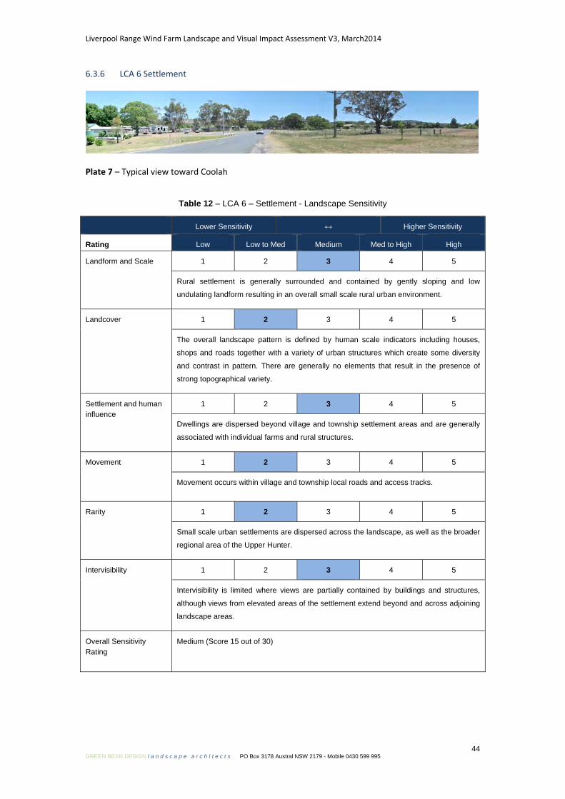
Liverpool Range Wind Farm Landscape and Visual Impact Assessment V3, March2014
44 GREEN BEAN DESIGN l a n d s c a p e a r c h I t e c t s PO Box 3178 Austral NSW 2179 - Mobile 0430 599 995
6.3.6 LCA 6 Settlement
Plate 7 – Typical view toward Coolah
Table 12 – LCA 6 – Settlement - Landscape Sensitivity
Lower Sensitivity ↔ Higher Sensitivity
Rating Low Low to Med Medium Med to High High
Landform and Scale 1 2 3 4 5
Rural settlement is generally surrounded and contained by gently sloping and low
undulating landform resulting in an overall small scale rural urban environment.
Landcover 1 2 3 4 5
The overall landscape pattern is defined by human scale indicators including houses,
shops and roads together with a variety of urban structures which create some diversity
and contrast in pattern. There are generally no elements that result in the presence of
strong topographical variety.
Settlement and human influence
1 2 3 4 5
Dwellings are dispersed beyond village and township settlement areas and are generally
associated with individual farms and rural structures.
Movement 1 2 3 4 5
Movement occurs within village and township local roads and access tracks.
Rarity 1 2 3 4 5
Small scale urban settlements are dispersed across the landscape, as well as the broader
regional area of the Upper Hunter.
Intervisibility 1 2 3 4 5
Intervisibility is limited where views are partially contained by buildings and structures,
although views from elevated areas of the settlement extend beyond and across adjoining
landscape areas.
Overall Sensitivity Rating
Medium (Score 15 out of 30)

Liverpool Range Wind Farm Landscape and Visual Impact Assessment V3, March2014
45 GREEN BEAN DESIGN l a n d s c a p e a r c h I t e c t s PO Box 3178 Austral NSW 2179 - Mobile 0430 599 995
6.4 Landscape values (local and regional)
6.4.1 What are landscape values?
For the purpose of this LVIA landscape values have been considered as a set of professional
judgements on the importance to society of the local and regional landscape surrounding the
proposed wind farm development. Societal landscape values may extend across a range of specific
interests such as historic, environmental or cultural issues. The purpose of identifying local and
regional landscape values is to consider what, if any, losses to landscape features or characteristics
may result from the construction and operation of the wind farm development, and how this may
impact upon local and regional landscape values.
6.4.2 Historical landscape values
Both the local and regional landscape has a strong association with early European settlement and
agricultural production and specifically the establishment of pastoral properties. The European
historical and cultural association with settlement and agrarian transition is set against a backdrop of
indigenous populations being relocated and ultimately removed from the landscape. The removal of
the indigenous population resulted in long held landscape cultural values and practices being replaced
by those employed by early settlers in the mid to early 19th century. Landscape change resulting from
the abrupt replacement of landscape values (from subsistence to industrial agriculture) has wrought
significant alteration to the landscape; however the existing landscape pattern is one that most
people at the local and regional scale would recognise as typical and representative of a rural
agricultural landscape. A detailed consideration and assessment of the relationship between
landscape and indigenous populations is described in the Aboriginal Cultural Heritage Assessment
Report within the EA.
6.4.3 Existing landscape values
Whilst the landscape is likely to hold more significant value at a local level, for those who both work
and reside within the landscape surrounding the proposed wind farm development, there are no
specific references to designations or policies which indicate or recognise a ‘high value’ landscape.
There are no ‘iconic’ landscape elements (including constructed or natural features) that occur within
the local or regional landscape which have a broader public value or that are recognised at a national
Liverpool Range Wind Farm Landscape and Visual Impact Assessment V3, March2014
46 GREEN BEAN DESIGN l a n d s c a p e a r c h I t e c t s PO Box 3178 Austral NSW 2179 - Mobile 0430 599 995
level. The majority of land within and surrounding the wind farm development is privately owned and,
at a local and regional scale, opportunities for the broader public to access and explore the landscape
and obtain distant and panoramic views are largely limited to existing rights of way such as road
corridors. The proposed wind farm development is not considered to have the potential to have a
significant impact on existing landscape values.
6.5 Summary
In terms of overall landscape sensitivity, this LVIA has determined that the landscape within the
viewshed of the proposed Liverpool Range wind farm has a medium to high sensitivity to
accommodate change, and represents a landscape that is reasonably typical of landscape types found
in surrounding areas of the Upper Hunter.
As a landscape with an overall medium to high sensitivity to accommodate change, recognisable
characteristics of the LCA will be altered by the proposed Project, and result in the introduction of
visually prominent elements that will alter the perceived characteristics of the LCA but may be
partially mitigated by existing landscape elements and features within the LCA. The main
characteristics of the LCA, patterns and combinations of landform and landcover will still be evident.
Despite being ‘naturalistic’ in appearance large portions of the Upper Hunter landscape have been
heavily modified by agricultural improvement for pasture and arable production post European
settlement. In more recent times large scale mining operations have emerged. Irrespective of the
extent and nature of modifications to the landscape, it is not correct to assume that the landscape
surrounding the wind farm should be any less valued as a result of modification. Physical change in
the appearance of the landscape is an ongoing and constant process from both human and
environmental influences and can result in both positive and negative effects.

Liverpool Range Wind Farm Landscape and Visual Impact Assessment V3, March2014
47 GREEN BEAN DESIGN l a n d s c a p e a r c h I t e c t s PO Box 3178 Austral NSW 2179 - Mobile 0430 599 995
Viewshed, zone of visual influence and visibility Section 7
7.1 Introduction
A key component of this LVIA is defined by the description, assessment and determination of the
viewshed, zone of visual influence and visibility associated with the wind farm. It is a combination of
these issues that sets out the framework for determining the significance and magnitude of potential
visual impact of the wind farm on view locations within the landscape.
In order to clarify and explain this component of this LVIA, the relationship between viewshed, zone
of visual influence and visibility is outlined and defined in Table 13.
Table 13 – Definitions
Definition Relationship
Viewshed An area of land surrounding and beyond
the Project area which may be potentially
affected by the wind farm.
Identifies the majority of this LVIA study
area that incorporates view locations that
may be subject to a degree of visual
impact.
Zone of Visual Influence (ZVI)
A theoretical area of landscape from which
the wind farm structures may be visible.
Determines areas within a viewshed from
which the wind turbines may be visible.
Visibility A relative determination at which a wind
turbine or cluster of wind turbines can be
clearly discerned and described.
Describes the likely number and relative
scale of wind turbines visible from a view
location.
An overview of viewshed, zone of visual influence and visibility is discussed in the following sections.
7.2 Viewshed
For the purpose of this LVIA viewshed is defined as the area of land surrounding and beyond the
Project area which could be potentially affected by the wind farm. In essence, the viewshed defines
this LVIA study area. The viewshed for the Project has been divided into a series of concentric bands
(at 2 km, 5 km and 10 km distance offsets) extending across the landscape from the wind turbines.
The viewshed extent can vary between wind farm projects, and be influenced or informed by a
number of criteria including the height of the wind turbines together with the nature, location and
height of landform that could limit visibility.
It is important to note that the wind turbines will be visible from some areas of the landscape beyond
the 10 km viewshed; however, within the general parameters of normal human vision, a wind turbine

Liverpool Range Wind Farm Landscape and Visual Impact Assessment V3, March2014
48 GREEN BEAN DESIGN l a n d s c a p e a r c h I t e c t s PO Box 3178 Austral NSW 2179 - Mobile 0430 599 995
at around 165 m to the tip of the rotor blade will occupy a relatively small proportion of a person’s
field of view from distances in excess of 10 km.
The viewshed is used as a framework and guide for visibility assessment, as the degree of visual
significance will tend to be gradated with distance although there are unlikely to be any distinct or
abrupt noticeable changes between the nominated distances.
7.3 Zone of Visual Influence
The ZVI diagrams are used to identify theoretical areas of the landscape from which a defined number
of wind turbines, or portions of turbines, could be visible within the viewshed. They are useful for
providing an overview as to the extent to which the Project could be visible from surrounding areas.
ZVI diagrams have been prepared to include:
• ZVI Diagram 1 from tip of blade;
• ZVI Diagram 2 from hub height; and
• ZVI Diagram 3 toward the whole turbine.
The extent to which the wind turbines may be visible are illustrated in Figure 11, and the ZVI
Diagrams in Figures 12, 13 and 14.
7.4 ZVI methodology
The methodology adopted for the ZVI is a purely geometric assessment where the visibility of the
Project is determined from carrying out calculations based on a digital terrain model of the site and
the surrounding terrain.
Calculations have been made to determine the visibility of the wind turbines:
• to blade tips (a view toward any part of the wind turbine, including views toward the tips of
blades above ridgelines);
• to hub height (a view toward any part of the wind turbine, including a view toward half the
swept path of the wind turbine blades); and
• to the whole turbine (a view toward the whole turbine).
The calculations also take into account the terrain relief and earth curvature.
Liverpool Range Wind Farm Landscape and Visual Impact Assessment V3, March2014
49 GREEN BEAN DESIGN l a n d s c a p e a r c h I t e c t s PO Box 3178 Austral NSW 2179 - Mobile 0430 599 995
This assessment methodology is conservative as:
• the screening effects of any structures and vegetation above ground level are not considered in
any way. Therefore the wind farm may not be visible at many of the locations indicated on the
ZVI diagrams due to the local presence of trees or other screening materials.
• additionally, the number of turbines visible is also affected by the weather conditions at the
time. Inclement or cloudy weather tends to mask the visibility of the proposed Project.
Accordingly, while ZVI diagrams are a useful visualisation tool, they are very conservative in nature.
7.5 ZVI summary
The most extensive and continuous area of visibility toward the Project turbines will generally occur
where the tips of the wind turbine rotor blades are visible above surrounding ridgelines or vegetation;
however, views toward the tips and upper portions of the wind turbine rotors are likely to become
less noticeable at reasonably short distances from the wind farm due to the screening influence of
topography and dense tree cover. Views toward tip of blade are visually negligible from medium to
longer distance view locations.
The ZVI diagrams for ‘tip’ and ‘hub height’ cover similar extents of landscape surrounding the wind
farm, and extend toward isolated pockets of rural landscape beyond 10 km of the nearest wind
turbine. The number and distribution of turbines visible between ‘tip’ and ‘hub’ height is influenced
by ridgelines and surrounding hills for a number of areas between the 5 km to 10 km distance offsets.
The ZVI diagrams illustrate areas of landscape which are likely to offer views toward the wind turbines
and demonstrate that the majority of views generally occur within private property and across tracts
of unoccupied rural landscape.
The ZVI diagrams also illustrate a number of discrete pockets within portions of the 5 km to 10 km
distance offset from which the wind turbines will not be visible, although this band of the viewshed
also represents areas from which a greater number of turbines will also be visible.
The ZVI diagrams illustrate that the influence of surrounding landform begins to disperse visibility
from beyond 5 km, although opportunities to view turbines from elevated, but moderately distant
and generally unoccupied areas occur from areas beyond 5 km.

'Tip of blade'
View toward 'tip of blade' - where views extend toward the tip of blades abovehill and ridgelines.
'Whole turbine'
View toward 'whole turbine' - where views extend from the base of the towerto the tip of the rotor blade.
'Hub height'
View toward 'hub height' - where views extend toward the upper half of thewind turbine rotor with views toward the lower half of the rotor face andtower screened by landform.
Figure 11ZVI visibility zones
LIVERPOOL RANGE WIND FARMLiverpool Range Wind Farm Pty Ltd

Distance from proposed Liverpool Rangewind turbine
Proposed Liverpool Range wind turbine
Involved residential dwelling within2 km of wind turbine
Proposed 330 kV powerline
Uninvolved residential dwelling within2 km of wind turbine
Uninvolved residential dwelling between2 km and 5 km of wind turbine
Uninvolved residential dwelling between5 km and 10 km of wind turbine
2km
5km
10km
2km
5km
10km
NOTES:
The ZVI methodology is a purely geometricassessment where the visibility of theproposed Liverpool Range wind farm isdetermined from carrying out calculationsbased on a digital terrain model of the site andthe surrounding terrain.
This assessment methodology is assumed tobe conservative as the screening affects of anystructures and vegetation above ground levelare not considered in any way. Therefore thewind farm may not visible at many of thelocations indicated on the ZVI maps due to thelocal presence of trees, vegetation or otherscreening potential. While the ZVI maps are auseful visualisation tool, they are veryconservative in nature.
Additionally, the number of turbines visible atany one time is also affected by the weathercondition at the time. Inclement or cloudyweather tends to mask the visibility of theproposed wind project.
0 - 20
21 - 40
41 - 60
61 - 80
81 - 100
101 - 200
>260
LEGEND:
Number of wind turbine tip of blade visible
Figure 12ZVI Diagram 1 Tip of blade
Liverpool Range Wind Farm Pty Ltd
LIVERPOOL RANGE WIND FARM
Sou
rce:
Cop
yrig
ht C
omm
onw
ealth
of A
ustra
lia (G
eosc
ienc
e A
ustra
lia) 2
012
http
://m
apco
nnec
t.ga.
gov.
au/M
apC
onne
ct/2
50K
/
0km 10km