Embed Size (px)
Citation preview

Living Atlas of the World: An Introduction
Bern Szukalski@[email protected]
Deane Kensok@[email protected]

ArcGIS includes a Living Atlas of the WorldMaps and Layers from Esri and Thousands of Contributors
… with Curated Content on Many Topics

Content is Published by Esri, Partners, and UsersBuilt by the ArcGIS Community and Curated by Esri
EsriContent
C O M M U N I T Y M A P S
PartnerContent
UserContent
NOAA Real-time Weather
Canal & River Trust
EEA Land Cover
Nearmap 7cm Imagery
Waze Traffic Incidents

Accessing Living Atlas through ArcGISMultiple ways to Experience Living Atlas through ArcGIS Apps
• ArcGIS Online & ArcGIS Enterprise (Portal)- Content: Living Atlas Content- Add Data: Browse Living Atlas Layers- Analysis: Choose Living Atlas Layers
• ArcGIS Living Atlas of the World Website- Browse and Contribute @ livingatlas.arcgis.com
• ArcGIS Pro- Open Maps, Add Layers, Perform Analysis
• Many Custom Apps by Esri and Users- Wayback, Water Balance, Green Infrastructure, Drought Tracker, …

DEMONSTRATION
Bern
DEMO SUGGESTIONS:
• Accessing Living Atlas Content• Content Page, Map Viewer, LAW Website

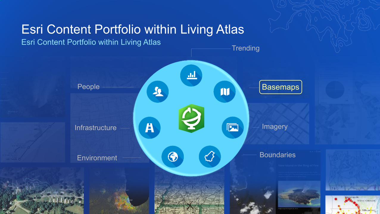
Esri Content Portfolio within Living AtlasEsri Content Portfolio within Living Atlas
Environment
Infrastructure
Boundaries
Imagery
BasemapsPeople
Trending
Esri Content Portfolio within Living AtlasEsri Content Portfolio within Living Atlas
Environment
Infrastructure
Boundaries
Imagery
BasemapsPeople
Trending
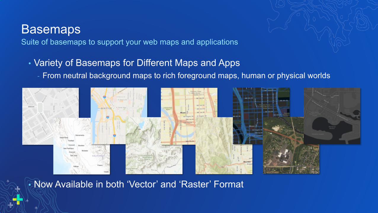
BasemapsSuite of basemaps to support your web maps and applications
• Variety of Basemaps for Different Maps and Apps- From neutral background maps to rich foreground maps, human or physical worlds
• Now Available in both ‘Vector’ and ‘Raster’ Format

Benefits of Vector BasemapsDelivering basemaps in vector tile format provides several benefits to users
• More Styles Available- Currently 9 ‘core’ styles from Esri- Several more ‘custom’ styles
• Customizable by Users & Developers- Turn layers on / off - Change colors and other renderers- Change labels for different languages- Change treatment of disputed places
• Look Great on Hi-Res Displays- Vector features and labels look sharper
• Easier to Update- Cache updates in hours, not weeks- Smaller cache is faster to update
• More Interactive- Display at any scale with clearer rendering- Rotate the map / live text
• Support Other Map Projections- Available in other projections (GCS, BNG, …)- Client-side re-projection of tiles
• Better Support Disconnected Use- Store larger areas on small devices

Esri Vector BasemapsWhat’s New
• Default in Gallery for Anonymous, Public Account Users & New Orgs- Enable to use in your ArcGIS Online Organization’s Basemap Gallery
• New Map Styles Available!- Community, Navigation (Dark Mode), National Geographic Style- Esri Styles in GCS WGS84 Tiling Scheme
• Localization: maps localized for different languages and regions- Languages: now includes default plus 18 languages (12 new since last UC)- Disputed Places: vector basemaps enable different treatments of disputed places
• Vector Tile Style Editor available in Map Viewer to create custom styles- Browser based editor to create and save new vector basemaps

OpenStreetMap Vector BasemapEsri hosted basemap featuring the latest OpenStreetMap data
• Basemap built using OSM data and cartography- Map is created with ArcGIS Pro and hosted in ArcGIS Online- Map is updated every 3 weeks with the latest OSM data
- Over time, Esri intends to update more frequently
• Online Map is freely available to all users and developers!- Provided und Creative Commons by Attribution (CC BY 4.0) license- Map available in ArcGIS Online Basemap Gallery
• New Map Styles- OpenStreetMap (Esri Streets style)- OpenStreetMap (Esri Imagery Hybrid style)- GCS WGS84 Tiling Scheme styles

DEMONSTRATION
Bern
DEMO SUGGESTIONS:
• Vector Basemaps• Now the Default for Many; How to Enable in
Your Org• New Map Styles (pick ~3 to highlight)• How to Access the Vector Tile Style Editor• OpenStreetMap: now in the gallery, updated
frequently

Community Maps Editor (New!)New Web Editing App to Create and Edit Data for Esri Basemaps
• Enables Users to Contribute to Esri Basemaps- Enhance detail for high-priority AOIs (e.g. parks, schools, …)
• Users Create and Edit Features in Web Browser- Buildings, parking lots, paths, recreation areas, trees, …- Compiled from Esri World Imagery basemap
• Advanced Editing Tools for High-Quality Data- Snap to features, curves & angles, pre-built stencils, copy / paste
• New Data Created is Available to Export (once accepted)- Creative Commons by Attribution (CC BY 4.0) Open License
Mercedes-Benz Stadium: Site of Super Bowl LIII
From the App …… to the Map

Community Maps ChallengesCommunity Effort to Enhance Important Parts of the Map
• Focused and Fun Opportunities for Contributors
• Initial Challenges have Included:- Major League Baseball Stadiums (US, CA)- World Cup and World’s Best Cricket Grounds (UK, AU, IN, NZ, ZA)- Current: Most Iconic City Parks (Many Countries)
• Additional Map Challenges Planned in 2019 and Beyond- College & High School Campuses- FIFA Football Stadiums (World Cup)- American Football Stadiums (NFL, College)- Open to Community Suggestions
Sophia Gardens
Angel Stadium
Challenge Status

Community Maps Editor Learn Path
• New Learn Path to learn how to use Editor app using “Sandbox” version- Introduction to the Community Maps Editor, including how to access- Series of learn lessons teaching tools and tips to create and edit features
- How to create an AOI, create buildings, cut and clip features, snapping, stencils, etc.
• Learn lessons focused on Use Case of Creating a School Campus- Can be used by colleges, high schools, and other students and educators- Can be applied to many other types of places (e.g. parks, malls, sports facilities, …)
• @ learn.arcgis.com (Digitize Your Neighborhood with Community Maps)

Esri Content Portfolio within Living AtlasEsri Content Portfolio within Living Atlas
Environment
Infrastructure
Boundaries
Imagery
BasemapsPeople
Trending

World ImageryEsri’s Flagship Imagery Basemap
• Map featuring Most Recent, High-res imagery from Best Available Sources- Includes metadata with source, acquisition date, resolution, accuracy, …
• Updates with DigitalGlobe basemap imagery (began Q3 2016)- Over 200 million sq. km. of imagery updated in past 3 years- Esri has extended partnership with DigitalGlobe …
- Imagery being enhanced in Currency, Clarity, and Accuracy
• Updates from GIS User imagery through Community Maps- Hundreds of contributions from national, provincial, and local sources
- Austria, Canada, Germany, Netherlands, Spain, Switzerland, United States, …
City of Berlin (Apr ‘18)

World Imagery: Small-Medium Scale Update (New!)• Esri has updated with TerraColor
NextGen from Earthstar Geographics• NextGen provides improvement in
currency, accuracy, and aesthetics
Natural Color - Processed using naturalcolor RGB bands from Landsat 8. NextGencolors look truly realistic providing smoothtransitions from low to high resolutions in WorldImagery.
Cloud-Free - With less than 0.5%cloud cover globally, NextGen
offers clear views of the earth.
Seamless - Thousands of Landsat 8images were color balanced and stitchedtogether to create a seamless view of the entireplanet.
Accurate - 12m CE90 - 90% of the pixels are within 12 meters from their actual earth locations.
Current - Built from newer (2013-2018)Landsat 8 imagery at a spatial resolution of 15meters per pixel.
TerraColor NextGen Over Kashmir

World Imagery: Small-Scale Before and After
Current World Imagery - TerraColor v1 Update to World Imagery - TerraColor NextGen

World Imagery: Medium-Scale Before and After
Current World Imagery - TerraColor v1 Update to World Imagery - TerraColor NextGen

DigitalGlobe Imagery EnhancementsVivid and Metro Products are being enhanced in 2019-2020
• Earthwatch Vivid (global) and Metro (1,000 metros)
• First collection of Enhanced Vivid imagery has been published for CONUS
Currency
Clarity
Accuracy
• Cloud processing enables global annual updates to Vivid (>50% refresh)
• HD will enable expanded 30cm GSD coverage for all Metros
• Large-area image bundling enables higher accuracy of Vivid (4-5m)

World Imagery (Clarity)Alternative view of the World Imagery map
• View of World Imagery featuring Imagery from Archive- Reveals a curated set of imagery from Esri’s multi-year archive
• Optimized for Image Clarity and Accuracy- Less haze or cloud cover, higher positional accuracy- Typically less current than default imagery content- May feature most recent imagery, if also clearest or most accurate
• Supports Use Cases that Require Imagery of Highest Clarity- Feature collection and editing, change detection, etc.
U.S. Capitol
Edinburgh Castle
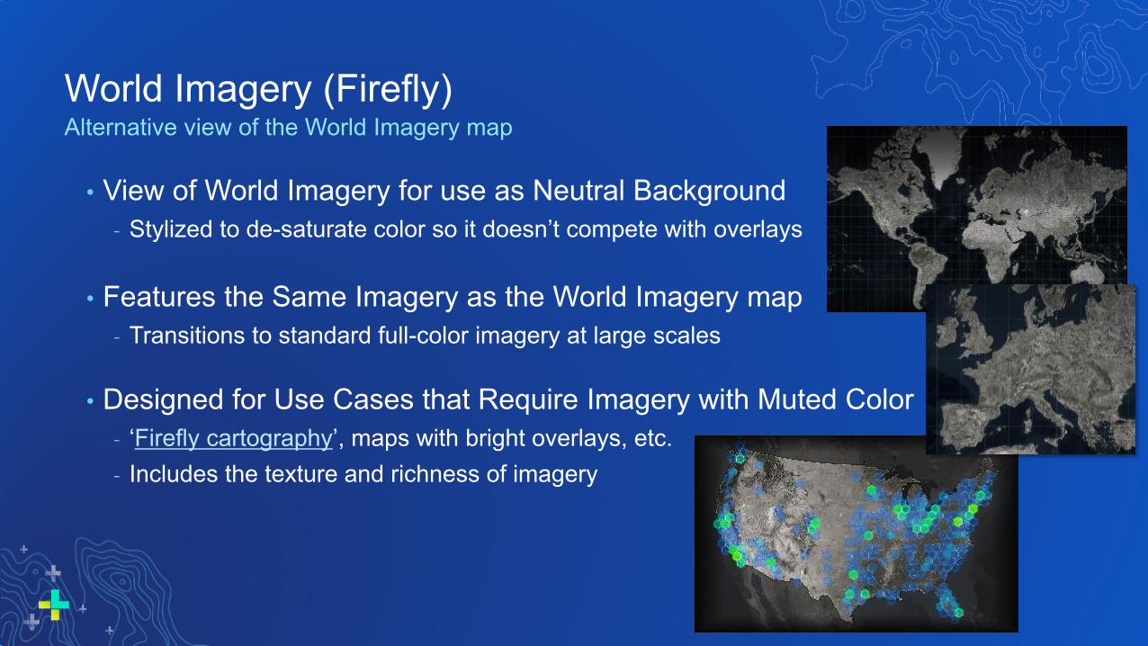
World Imagery (Firefly)Alternative view of the World Imagery map
• View of World Imagery for use as Neutral Background- Stylized to de-saturate color so it doesn’t compete with overlays
• Features the Same Imagery as the World Imagery map- Transitions to standard full-color imagery at large scales
• Designed for Use Cases that Require Imagery with Muted Color- ‘Firefly cartography’, maps with bright overlays, etc.- Includes the texture and richness of imagery
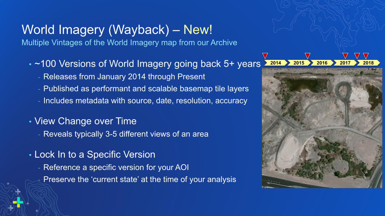
World Imagery (Wayback) – New!Multiple Vintages of the World Imagery map from our Archive
• ~100 Versions of World Imagery going back 5+ years- Releases from January 2014 through Present- Published as performant and scalable basemap tile layers- Includes metadata with source, date, resolution, accuracy
• View Change over Time- Reveals typically 3-5 different views of an area
• Lock In to a Specific Version- Reference a specific version for your AOI- Preserve the ‘current state’ at the time of your analysis
2014 2015 2016 2017 2018

Landsat 8 ImageryGlobal 15-30m imagery for regional land analysis
• Global: Multi-temporal, Multi-spectral• New scene every 16 days (cloud permitting)
- Updated daily with approx. 400 scenes
• Dozens of scenes available per location- Now Hosted on Amazon Web Services (AWS)
• Freely Accessible by all ArcGIS Users!
• Landsat GLS Imagery also Available- Multi-epochs available from 1975 to 2010
• Polar Landsat Services also Available!- Image services in Arctic and Antarctic projections
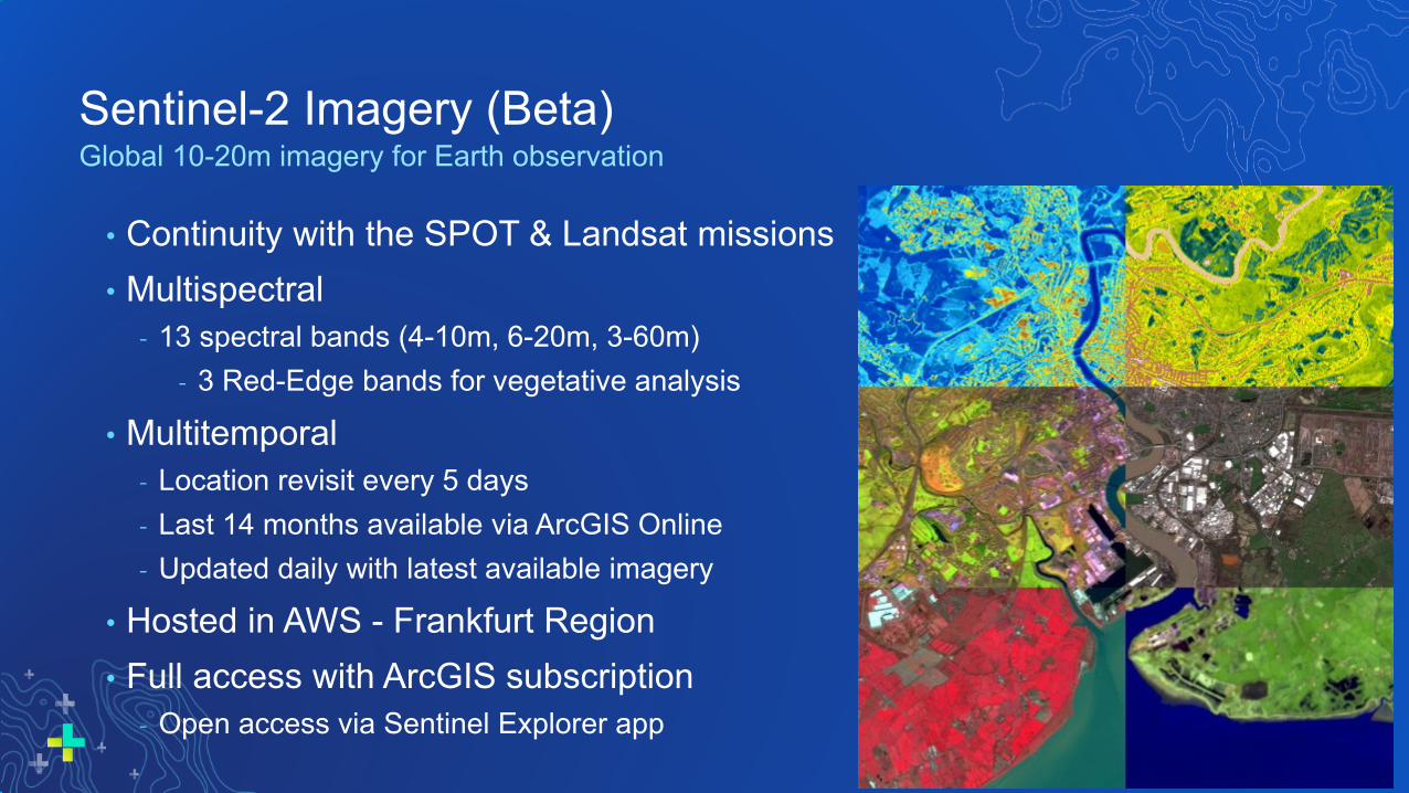
Sentinel-2 Imagery (Beta)Global 10-20m imagery for Earth observation
• Continuity with the SPOT & Landsat missions• Multispectral
- 13 spectral bands (4-10m, 6-20m, 3-60m)- 3 Red-Edge bands for vegetative analysis
• Multitemporal- Location revisit every 5 days- Last 14 months available via ArcGIS Online- Updated daily with latest available imagery
• Hosted in AWS - Frankfurt Region• Full access with ArcGIS subscription
- Open access via Sentinel Explorer app

DEMONSTRATION
Bern
DEMO SUGGESTIONS:
• World Imagery• How to access Imagery Metadata• Wayback Imagery (highlight interesting AOI,
such as Mercedes-Benz stadium)• Firefly or Sentinel Imagery?

Esri Content Portfolio within Living AtlasEsri Content Portfolio within Living Atlas
Environment
Infrastructure
Boundaries
Imagery
BasemapsPeople
Trending

World Elevation: now includes Airbus WorldDEM4OrthoWhat’s New
• Global pole to pole- exceptions Azerbaijan, DR Congo, Ukraine
• 0.8 arc sec (~ 24.7 meter) resolution- 4 meter vertical accuracy* at global scale
• Improvements to:- World Elevation Image Service (Terrain & TopoBathy)- Analysis Services (Profile, Viewshed, Summarize)- 3D Elevation (Terrain3D & TopoBathy3D)- World Hillshade
* Excluding urban areas (DTM like areas), substituted areas, areas of Antarctica

World Hillshade (Dark) – New!
• Dark version of our popular Multi-Directional Hillshade product• Use as a backdrop to highlight feature layers and labels• Now Available as a Cached Tile Service (basemap)
Major earthquakes over central Asia Hiking trails over Switzerland National Park
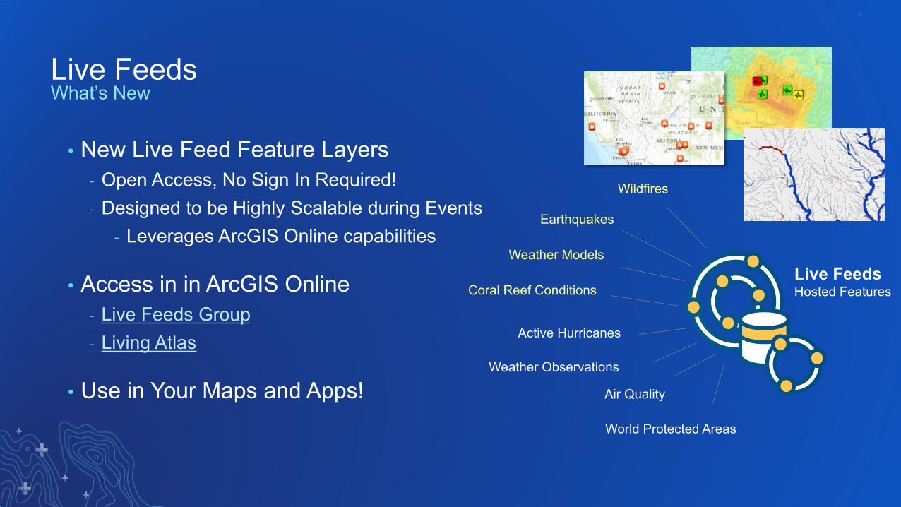
Live FeedsHosted Features
Wildfires
Earthquakes
Weather Observations
Weather Models
Coral Reef Conditions
Air Quality
World Protected Areas
Active Hurricanes
Live Feeds
• New Live Feed Feature Layers- Open Access, No Sign In Required!- Designed to be Highly Scalable during Events
- Leverages ArcGIS Online capabilities
• Access in in ArcGIS Online- Live Feeds Group- Living Atlas
• Use in Your Maps and Apps!
What’s New

USA CroplandsUpgraded to 2018 data
Full time series (2008-2018)Add major crop frequencies
USA SoilsUpgraded to 2018 data
Enhanced table attributesUpgrade downloader app to PPKX
USA Protected AreasUpgraded to version 2.0Hosting image, feature layer views, &
vector tilesSupporting USGS maps and apps
National Land Cover DatabaseUpgraded to 2016 dataFull timeseries from (2006 – 2016)Data is harmonized for analysis
USA Landscape Content

DEMONSTRATION
Bern
DEMO SUGGESTIONS:
• Environment• World Hillshade (Dark)• Time Enabled Cropland (web app in blog)• New Environmental Dashboards (Earthquake
Monitoring, Active Fires, Coral Bleaching)


Please Share Your Feedback in the App
Download the EsriEvents app and find
your event
Select the session you attended
Scroll down to “Survey”
Log in to access the survey
Complete the survey and select “Submit”