Embed Size (px)
Citation preview

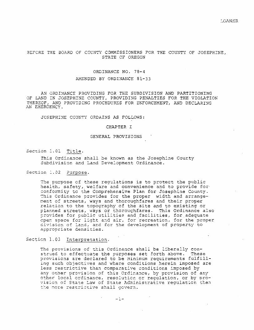
LOANER
SEFORE THE aOARD O F COUNTY COMMISSIONERS FOR THE COUNTY OF JOSEPHINE, STATE OF O F E G O N
ORDINANCE NO. 78-4
APIENDED 13Y ORDINANCE 81-33
AN ORDINANCE PROVIDING FOR THE SUBDIVISION AND PARTITIONING O F LAND I N JOSEPHINE COUNTY, PROVIDING PENALTIES FOR THE VIOLATION THEREOF, AND PROVIDING PROCEDC'RES FOR ENFORCEMENT, AND DECLARING AN ENERGENCY.
JOSEPHINE COUNTY ORDAINS AS FOLLOWS:
CHAPTER I
GENERAL PROVISIONS
S e c t i o n 1 . 0 1 T i t l e .
This Ord inance s h a l l b e known a s t h e J o s e p h i n e County S u b d i v i s i o n and Land Development Ord inance .
S e c t i o n 1 . 3 2 Purpose .
The pu rpose of t h e s e r e g u l a t i o n s is t o p r o t e c t t h e p u b l i c h e a l t h , s a f e t y , w e l f a r e and convenience and t o p r o v i d e f o r con fo rmi ty t o t h e Comprehensive P l a n f o r J o s e p h i n e County. Th i s Ord inance p r o v i d e s f o r t h e p r o p e r w i d t h and a r r a n g e - m e n t of s t r e e t s , ways and t h o r o u g h f a r e s and t h e i r p r o p e r r e l a t i o n t o t h e topography of t h e s i t e and t o e x i s t i n g o r p lanned s t r e e t s , ways o r t h o r o u g h f a r e s . Th i s Ord inance a l s o p r o v i d e s f o r p u b l i c u t i l i t i e j and f a c i l i t i e s , f o r . a d e q u a t e open s p a c e f o r l i g h t and a i r , f o r r e c r e a t i o n , f o r t h e p r o p e r 2 iv ; s ion o f l a n d , and f o r t h e development of p r o p e r t y t o a ~ p r o p r i a t e d e n s i t i e s .
S e c t i o n 1 . 0 3 I n t e r p r e t a t i o n .
The p r o v i s i o n s of t h i s Ord inance s h a l l b e l i b e r a l l y con- s t r u e d t o e f f e c t u a t e the p u r p o s e s s e t f o r t h above . These p r o v i s i o n s a r e d e c l a r e d t o b e minimum r e q u i r e m e n t s f u l f i l l - i n g such o b j e c t i v e s and where c o n d i t i o n s h e r e i n imposed a r e l e s s r e s t r i c t i v e t h a n compara t i ve c o n d i t i o n s imposed by any o t h e r p r o v i s i o n of t h i s Ord inance , by p r o v i s i o n o f any o t h e r l o c a l o r d i n a n c e , r e s o l u t i o n o r r e g u l a t i o n , o r by pro- v i s i o n o f S t a t e Law of S t a t e A d m i n i s t r a t i v e r e g u l a t i o n t h e n t h e more r e s t r i c t i v e s h a l l gove rn .

The ~ r o v i s i o n s of c h i s Grdinance a r e s e v e r a b l e . 15 any sec- t i o n , s e n t e n c e , cl izuse o r p h r a s e 05 t h i s Ord inance i s ad juaged co b e i x v a l l e by a C a u r t of c ~ m p e t e n t j u r i s d i c t i o n , t h a t d e c i s i o n s h a l l n o t a f f e c t t h e v a l i d i t y of t h e remain ing por- t i o n s af t h i s Ord inance .
S e c t i o n 1 .05 E d i t o r i a l Rev i s ion .
The County Counsel o r D i s t r i c t A t t o r n e y may a t any t i m e d i r e c t such changes r e g a r d i n g c u r r e n t l y m a i n t a i n e d c o p i e s of t h i s Ordinance and Amendments a s t h e L e s i s l a t i v e Counsel i s au tho- r i z e d t o p e r f o m r e g a r d i n g a c t s of - t h e L e g i s l a t u r e , p u r s u a n t t o ORS 173.160, p rov ided t h a t such e d i t o r i a l r e v i s i o n s b e d i r e c t e d by w r i t t e n memorandum f i l e d w i t h t h e County C l e r k , s u b j e c t t o d i s a p p r o v a l by t h e P l a n n i n g Commission a t i t s nex t meet ing t h e r e a f t e r .
S e c t i o n 1.06 D e f i n i t i o n s .
A s used i n t h i s Ordinance t h e mascu l ine gender i n c l u d e s t h e femlnine and n e u t e r gende r an& the s i n g u l a z i n c l u d e s t h e ~ l u r a l . The f o l l o w i n g words and p h r a s e s , u n l e s s t h e c o n t e x t oche rwl s s r e q u i r e s , s h a l l m e h n :
A b u t t e r . An i n d i v i d u a l , f i r m , a s s o c i a t i o n , s y n d i c a t e , c o r p o r a t i o n o r o t h e r l e g a l e n t i t y hav ing an i n t e r e s t i n p r o p e r t y b o r d e r i n g on a p u b l i c road .
A l l e y . A p u b l i c o r p r i v a t e way n o t more t h a n t h i r t y (30 ) f e e t wlde a f f o r d i n g o n l y seconda ry means o f a c c e s s t o a b u t t i n g p r o p e r t y . . - -
Block. An a r e a of l a n d w i t h i n a s u b d i v i s i o n which may = t i r e l y bounded by s t r e e t s , highways o r w a y s ( e x c e p t a l l e y s ) , and t h e e x t e r i o r boundary o r b o u n d a r i e s o f t h e s u b d i v i s i o n .
Board. The Board of County Commissioners o f J o s e p h i n e County.
3 u i l d i n g L i a e . A l i n e i n d i c a t i n g t h e . l i m i t beyond which b u i l d i n g s o r s t r u c t u r e s may n o t be e r e c t e d .
Commission. The P lann ing Commission of t h e County o r o t h e r l e g a l body hav ing j u r i s d i c t i o n , i n c l u d i n g where a p p l i c a b l e t h e County Zoning Commission, P l a n n i n g D i r e c t o r , o r o t h e r body w i t h l e g a l j u r i s d i c t i o n .
Comprehensive P l a n . County Commissioners
&
velopment of t h e cou conformance x i t h ORS
The P l a n adop ted by t h e Board o f f o r t h e gu idance o f growth and de-
nty, which i s p r e p a r e d and adop ted i Chapter 2 1 5 and ORS Chapter 197 .

County Xoad o r S t r z e t . A p u b l i c way which has been a c c e p t e d by zhe Board o f County Commissioners by ded ica - t i o n o r deed o r g r a n t o f r igh t -of -way .
Countv Main ta ined Road o r S t r e e t . A r o a d o r s t r ee t and a p p u r t e n a n c e s which h a s been a c c e p t e d f o r County main- t e n a n c e by o r d e r of t h e Board of County Commissioners under t h e a u t h o r i t y o f ORS 369.551, o r any o t h e r p r o v i - s i o n s of law.
Cul-de-sac. The v e h i c l e t u r n a r o u n d p o r t i o n of a dead end r o a d .
Curb L ine . The ' l i n e s e p a r a t i n g t h e roadway from t h e p l a n t i n g s t r i p o r footway.
Design. The d e s i g n of any s t r ee t o r a l l e y a l i g n m e n t , g r a d e o r w i d t h , o r t h e a l i gnmen t o r w i d t h of easements and r igh t -of -way f o r d r a i n a g e o r i r r i g a t i o n p u r p o s e s and s a n i t a r y f a c i l i t i e s , and l o t a r e a , w i d t h o r l a y o u t .
>
Developer . A s u b d i v j . d ~ , o r p a r t i t i o n e r , o r i f n o t c r e a t i n g a s u b d i v i s i o n o r p a r t i t i o n , a p e r s o n who a s a r e s u l t of such subdivis-$on o r p a r t i t i o n p u r p o s e s t o , o r does deve lop t h e l a n d , whe the r i t b e f o r p u b l i c o r p r i - v a t e p u r p o s e s .
Driveway. A way of a c c e s s f o r a v e h i c l e t o s e r v e a l i m i t e d number of u s e r s from a p u b l i c r o a d o r s t r e e t , which i s ~ s u a l l y of narrow w i d t h and o f t e n i n p r i v a t e ownersh ip o r s u b j e c t t o r e s . t r i c t e d p u b l i c u s e .
Driveway Approach. A v e h i c l e a c c e s s c o n s t r u c t e d t o s t a n d a r d s adopted by t h e Board o f County Commissioners from a p u b l i c r igh t -of -way t o p r o p e r t y which a b u t s a p u b l i c s t r ee t .
Easement. A g r a n t of t h e r i g h t t o u se t h e p r o p e r t y of .
a n o t h e r f o r a s p e c i f i c p u r p o s e ; may b e e i t h e r a p p u r t e n a n t o r i n g r o s s .
F l a g l o t . A u n i t of land. c r e a t e d . b y a s u b d i v i s i o n o r p a r t i t i o n and which i n c l u d e s a narrow p r o j e c t i o n t o a p u b l i c r o a d , and which p r o j e c t i o n i s commonly known a s t h e " f l a g ~ o l e " .
Half S t r e e t . A p o r t i o n of t h e w i d t h of a s t r e e t , u s u a l l y a l o n g t h e edge of a s u b d i v i s i o n where t h e r ema in ing por- t i o n o f t h e s t r e e t has been, o r c o u l d l a t e r be, p r o v i d e d i n a n o t h e r s u b d i v i s i o n .
L o t . A a n i t of l a n d t h a t i s c r e a t e d by a s u b d i v i s i o n - of l a n d .
>!ajar P a r t i z i o ~ . A 2 a r t i c i o n whlch i n c l u d e s t h e c r e a k i o n of a road c r s r r e e t .

> l a r g F n a l Access S t r e e t . A minor s t r e e t p a r a l l e l and a d j a c e ~ t t a a major a r t e r i a l s t r e e t , p r o v i d i n g a c c e s s t c a b u t t i n g p r o p e r t i e s , b u t p r c t e c t e d from t h r o u g h t r a f f i c .
X ~ F . A f i n a l d iagram, drawing , o r o t h e r w r i t i n g concern- - i n g a major p a r t i t i o n .
Metes and Bounds. A d e s c r i p t i o n o f a t r a c t of l a n d by a sequence o f c o u r s e s hav ing a d i r e c t i o n o f t r a v e l around t h e p e r i m e t e r of t h e t r a c t , s a i d c o u r s e s b e i n g f i x e d by a d j o i n e r s , monuments, d i r e c t i o n , d i s t a n c e , o r a l l f o u r .
Minor P a r t i t i o n . A p a r t i t i o n i n which a l l p a r c e l s have a c c e s s by an e x i s t i n g p u b l i c road o r s t r e e t , and which 2oes n o t i n c l u d e t h e c r e a t i o n of a road o r s t r ee t .
Mortgage L o t . A p a r c e l o r l o t c r e a t e d t o p r o v i d e s e c u r i t y f o r t h e pu rchase p r i c e o f t h a t p a r c e l o r l o t o r improve- ment t h e r e o n and which does:_riet i n v o l v e a t r a n s f e r of l e g a l t i t l e and possessi&n-. - .- -
" -
O f f i c i a l Map. The map o r maps upon which l o c a t k n s a r e l o c a t e d i n d e t a i l and w i t h e x a c t n e s s , s o a s t o f u r n i s h t h e b a s i s f o r p r o p e r t y % c q u i s i t i o n o r b u i l d i n g r e s t r i c - t i o n s .
Gwner. n e r s h i p i n l a n d
An i n d i v i d u a l , f i r m , a s s o c i a t i o n , o r c o r p o r a t i o n having any p r o p r i
sough t t o b e s u b d i v i d e d o r p a r t i t
s y n d i e t a r y . ioned
t h e s e r e g u l a t i o n s and - o t h e r - a p p l i c a b l e law. - *
c a t e , pa i n t e r e s t under
P a r c e l . A u n i t of - land t h a t i s c r e a t e d by a p a r t i t i o n i n g o f l a n d , l n t e n d e d f o r I e a s e , t r a n s f e r o f owner sh ip , o r development .
P a r t i t i o n . E i t h e r an a c t of p a r t i t i o n i n g l a n d o r a n a r e a o r t r a c t of l and p a r t i t i o n e d a s d e f i n e d i n t h i s s e c t i o n .
P a r t i t i o n Land. To d i v i d e an a r e a o r t r a c t of l a n d i n t o two o r t h r e e p a r c e l s w i t h i n a c a l e n d a r y e a r when such a r e a o r t r a c t of l and e x i s t s a s a u n i t o r c o n t i g u o u s u n i t s of l a n d under s i n g l e ownershi? a t t h e b e g i n n i n g of such y e a r . " P a r t i t i o n land" does no t inc lude d i v i s i o n s of land r e s u l t i n g from l i e n f o r e c l o s u r e s , d i v i s i o n s o f l a n d r e s u l t i n g from f o r e c l o s u r e of r eco rded c o n t r a c t s f o r t h e s a l e o f r e a l p r o p e r t y and d i v i s i o n s o f l and r e s u l t i n g from t h e c r e a t i o n of cemetery l o t s ; and " p a r t i t i o n l a n d " does n o t i n c l u d e any a d j u s t m e n t of a l o t l i n e by t h e r e l o c a t i o n o f a common boundary where an a d d i t i o n a l p a r c e l i s n o t c r e a t e d and where t h e e x i s t i n g p a r c e l reduced i n s i z e by t h e ad jus tmen t Is n o t reduced. below t h e minimum l o t s i z e e s t a b l i s h e d by any a p e l i c a b l e zoning ord i r -ance . " P a r t i t i o n l and" does

a U) aJaJ rn vL4 aJ rd 0 rd k a
: E m E i U k C rl 0 4 k
UI a o c -daJ? U .
C 4 m 3 m c , o u m m a ,
h . 4 k a LI w: aaJrda, ac,rl.r( - . C U 3 l l = G 3.4 U.4 aJ 0 0 kdrl 3.4 a c,A-4-dc,
ma)+J k a a)a,33TJC C k = tr 4JCu-lU-l -4 7 0 0 - m
C - a, a, k a,c,-ha a o m c a 3'H 0 a, 3 k c, a E C d a , m ~ a , t n d ,Q (U 3 U4.d a ardC.5
C - d d = c,+a,a m a o z - .d k4J a,= k 3 a c ~ a ,
L l 4 J aJz Cuco arc, k U W 5 k 0 .4 . r i C c, c,.!za,rdrnk

4 . 3 x a l Rozids. Any coun ty road i n an a r e a n o t s e r v e d Sy p a 5 1 i c s a n i t a r y sewers where d i v i s i o n o f l a n d I s l i m i t e d
-
one a c r e s i z e o r l a r g e r .
%jar C o l l e c t o r - A r u r a l road p r o v i d i n g s e r v i c e between t r a f f i c g e n e r a t o r s and l a r g e r towns o r w i t h r o u t e s of h i s h e r c l a s s i f i c a t i o n , a s d e s i g n a t e d on t h e F u n c t i o n a l Highway C l a s s i f i c a t i o n maps o f J o s e p h i n e County a s p e r i o d i c a l l y r e v i s e d .
Minor C o l l e c t o r - Rura l r o a d s spaced a t i n t e r v a l s consistent w i t h p o p u l a t i o n d e n s i t y t o c o l l e c t and d i s t r i b u ~ e t r a f f i c f rom/ to l o c a l r u r a l r o a d s acd b r i n g a l l deve loped a r e a s w i t h i n a r e e s o n a b l e d i s - t a n c e of a c o l l e c t o r system a s d e s i g n a t e d on t h e F u n c t i o n a l Highway C l a s s i f i c a t i o n Maps of J o s e p h i n e County a s p e r i o d i c a l l y r e v i s e d .
0 L C .
Loca l - A ru ra l . r o a d p r s v i d i n g a c c e s s between r e s i - d e n t i a l roads and road sys tems o f - h i g h e r o r d e r o r p r o v i d i n g a l t e r n a t e c r o s s l i n k a g e between r o a d s o f h i g h e r o r d e r b u t n o t s e r v i n g a s a c o l l e c t o r .
R e s i d e n t i a l - A r u r a l road p r o v i d i n g d i r e c t a c c e s s t o a b u t t i n g l a n d and a c c e s s t o l o c a l r u r a l roads o r h i g h e r o r d e r road sys tems . The number of l o t s t o be s e r v e d s h a l l be 6 0 o r l e s s .
L imi ted R e s i d e n t i a l - A r u r a l road p r o v i d i n g d i r e c t a c c e s s t o a b u t t i n g l a n d and a c c e s s t o l o c a l r u r a l r o a d s o r r o a d s o f - h i g h e r o r d e r . T h i s i s a road i n t e n d e d e x c l u s i v e l y f o r a c c e s s t o a b u t t i n g p r o p e r t y where t h e number o f l o t s i s permanent ly r e s t r i c t e d because one end t e r m i n a t e s i n a cu l -de - sac w i t h o u t a s t r ee t p l u g . I n a r e a s where t h e topography is g e n t l y r i s i n g , less t h a n 15% s i d e s l o p e s , t h e number of l o t s s e r v e d s h a l l b e 1 0 o r less and t n e l e n g t h i s n o t t o exceed 1300 f e e t . I n a r e a s where t h e t e r r a i n i s s t e e p e r , more t h a n 15% s i d e s l o p e s , t h e number of l o t s s e r v e d s h a l l n o t exceed 20 l o t s and t h e l e n g t h s h a l l n o t exceed 2 6 0 0 f e e t .
4 2 . S idewalk . A p e d e s t r i a n walkway w i t h permanent s u r f a c i n g .
4 3 . Site P l a n Committee. A t e c h n i c a l r ev i ew committee e s t a b - l i s h e d p u r s u a n t t o t h e ' a u t h o r i t y d e l e g a t e d by t h e Board of County Commissioners i n t h e Zoning Ord inances , normal ly c o n s i s t i n g of t h e P l ann ing D i r e c t o r o r h i s a s s i s t a n t s , t h e D i r e c t o r of P u b l i c Works o r h i s a s s i s t a n t s , t h e B u i l d i n g S a f e t y D i r e c t o r o r h i s a s s i s t a n t s , t h e D i r e c t o r o f t h e Hea l th Department o r h i s a s s i s t a n t s , and t h e F i r e Y a r s h a l l . R e p r e s e n t a t i v e s of o t h e r a g e n c i e s and t h e C i t y 35 Gran t s Pas s Tay be i n v i t e d t o p a r t i c i p a t e a s a c p r o p r i a t 2 .
44. S t r e e t P lug o r Reserve S t r i ? . A narrow s t r i p o f l a n d c o n t r o l l i n g a c c e s s t o a s t r e e t 0.r h a l f s treec, t i t l e t o which i s h e l d by t h e County and t h e c o n t r o l of which r e s t s w i t h t h e Board of County Commissioners f o r d i s p o s a l a c c o r d i n g t o t h e i r d i s c r e t i o n c o n s i s t e n t w i t h t h e s e r e g u l a t i o n s .
4 5 . Subd iv ide . To e f f e c t a s u b d i v i s i o n , a s a p p l i e d t o t h i s Ord inance .
4 6 . S u b d i v i d e r . Any p e r s o n , a s d e f i n e d h e r e i n , who under- t a k e s p roceed ings t o e f f e c t a s u b d i v i s i o n o f l a n d , i n - c l u d i r q changes i n s t r e e t o r l o t l i n e s , f o r t h e pu rpose . of t r a n s f e r of ownership o r development.
1 7 . Subd iv ide Land. To d i v i d e an a r e a o r t r a c t of l a n d i n t o f o u r o r more l o t s w i t h i n a c a l e n d a r y e a r when such a r e a o r t r a c t of l a n d e x i s t s a s a u n i t o r c o n t i g u o u s u n i t s of l a n d under a s i n g l e 7 0 w n e r s h i p , a t t h e beg inn ing of such y e a r . Fo r pu rposes o f t h i s s e c t i o n , d i v i s i o n w i t h i n t h e c a l e n d a r y e a r of t h e o r i g i n a l u n i t o r c o n t i g u o u s u n i t s of l a n d between t h o s e c o n s t i t u t i n g s i n g l e ownership a t t h e beg inn ing of such y e a r s h a l l c o n s t i t u t e t h e c r e a t i o n of s e p a r a t e p a r c e l s .
4 8 . S u b d i v i s i o n . Means e i t h e r an a c t of s u b d i v i d i n g l a n d o r an a r e a o r a t r a c t of l a n d subd iv ided a s d e f i n e d i n t h i s s e c t i o n .
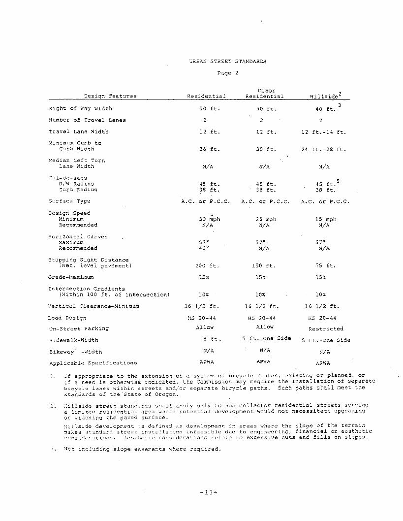
4 9 . Urban S t r e e t s . Any coun ty - road i n an a r e a s e r v e d by p u b l i c s a n i t a r y sewers where d i v i s i o n o f l a n d i s pe r - m i t t e d t o one a c r e s i z e o r - s m a l l e r .
a . C o l l e c t o r - An urban s t r e e t p r o v i d i n g l a n d a c c e s s , s e r v i c e and t r a f f i c c i r c u l a t i o n w i t h i n r e s i d e n t i a l neighborhoods d i s t r i b u t i n g t r i p s t o and from a r t e r i a l s th rough t h e a r e a t o l o c a l streets, a s d e s i g n a t e d on t h e F u n c t i o n a l Highway C l a s s i f i c a t i o n Maps o f J o s e p h i n e County, a s p e r i o d i c a l l y r e v i s e d .
b . Local - An urban s t r e e t p r o v i d i n g d i r e c t a c c e s s t o a b u t t i n g l a n d and a c c e s s t o h i g h e r o r d e r road system i n Urban S t r e e t a r e a .
c . Xinor - 4 dead-end cu l -de-sac s t r ee t w i t h o u t a p o s s i b i l i t y o f e x t e n s i o n , n o t l o n g e r t h a n 5 0 0 f e e t f r o m t h e i n t e r s e c t i o n w i t h a l o c a l o r c o l l e c t o r s t r e e t , and s e r v i n g no more than 1 5 l o t s o r p a r c e l s .
5 0 . Way. A s t r i p of l a n d , whether p u b l i c o r p r i v a t e , p ro- v i d i n g a c c e s s t o some o r a l l a d j o i n i n g l a n d owner sh ips .
S e c t i o n 1 . 0 7 Compliance.
N o land wit l l in t h e x n i n c o r 2 o r a t e d t e r r i t o r y of Zosephine Zounty s h a l l be subdivided o r p a r t l e i o n e d , e x c e p t a s

p r a v l 2 e Z in chis Ordinance, and no ~ l a t s h a l l ke filed o r recorced zr,ril submitted tc andapproved by the C o n ~ i s s i o n 2nd I3oazZ of County C o m i s s i o n e r s .

CHAPTER 2
BASIC PROVISIONS AND D E S I G N STANDARDS
S e c t i o n 2 . 0 1 Minimum S t a n d a r d s .
The r equ i r emen t s and s t a n d a r d s se t f o r t h i n t h i s c h a p t e r a r e t h e minimum ones t o which a s u b d i v i s i o n o r p a r t i t i o n must con- form b e f o r e a p p r o v a l by t h e Commission, e x c e p t a s p rov ided i n Chapter 7 and S e c t i o n 9 . 0 6 of t h i s Ord inance .
S e c t i o n 2 . 0 2 Conformity t o t h e Comprehensive P l a n and O f f i c i a l Map.
The s u b d i v i s i o n o r p a r t i t i o n s h a l l conform t o and b e i n ha r - mony w i t h the . J o s e p h i n e County Comprehensive P l a n Tex t and Comprehensive P l an Map of t h a t p o r t i o n of t h e County w i t h i n which t h e s u b d i v i s i o n o r p a r t i t i o n l i e s , and s h a l l p r o v i d e r ight-of-way d e d i c a t i o n i n conformance w i t h an o f f i c i a l map, adopted f o r t h a t a r e a .
S e c t i o n 2 .'03 R e l a t i o n t o Ad jo in ing S t r e e t System.
A s u b d i v i s i o n o r major p a r t i t i o n s h a l l p r o v i d e f o r t h e con- t i n u a t i o n of t h e p r i n c i p a l s t r e e t s e x i s t i n g i n a d j o i n i n g sub- d i v i s i o n s o r of t h e i r p r o p e r p r o j e c t i o n when t h e a d j o i n i n g p r o p e r t y i s n o t s u b d i v i d e d , and such s t reets s h a l l be of a w id th n o t l e s s t h a n t h e minimum requ i r emen t s f o r s t r e e t s se t f o r t h i n t h e s e r e g u l a t i o n s . Where, i n t h e o p i n i o n of t h e Commission, t o p o g r a p h i c c o n d i t i o n s make such c o n t i n u a t i o n o r con fo rmi ty i m p r a c t i c a l , e x c e p t i o n may b e made. I n c a s e s where t h e Commission a d o p t s a p l a n o r p l a t o f a neighborhood o r a r e a of which t h e s u b d i v i s i o n i s a p a r t , t h e s u b d i v i s i o n s h a l l con- form t o such adop ted neighborhood o r a r e a p l a n . Where t h e p l a t s u b m i t t e d c o v e r s o n l y a p a r t of t h e d e v e l o p e r ' s t r a c t , a draw- i n g of t h e p r o s p e c t i v e f u t u r e s t r e e t sys tem o f t h e p a r t sub- m i t t e d s h a l l be c o n s i d e r e d i n l i g h t of i t s c o n f o r m i t y t o t h e s t r e e t system of t h e e n t i r e t r a c t . S u b d i v i s i o n s o r major p a r t i t i o n s s h a l l be c r e a t e d w i t h s t r e e t s t h a t c o n n e c t t o an e x i s t i n g p u b l i c l y m a i n t a i n e d s t r e e t , u n l e s s o t h e r w i s e approved by t h e P l ann ing Commission.
S e c t i o n 2 . 0 4 Alignment.
A s f a r a s p r a c t i c a l , s t ree ts o t h e r t h a n l i m i t e d r e s i d e n t i a l o r r e s i d e n t i a l s t r e e t s s h a l l be i n a l i gnmen t w i t h e x i s t i n g s t r e e t s by c o n t i n u a t i o n s of t h e c e n t e r l i n e s t h e r e o f . S t agge red s t r e e t a l i gnmen t r e s u l t i n g i n "T" i n t e r s e c t i o n s s h a l l , wherever p r a c t i c a l , l e a v e a minimum d i s t a n c e o f 2 0 0 f e e t between t h e c e n t e r l i n e s of s t r e e t s hav ing approx ima te ly A e same d i r e c t i o n b u t i n no c a s e s h a l l it be l e s s t h a n 1 0 0 ? zeex .

S e c t i o n 2 . 0 5 I ialf S t r e e t s .
Half s t r e e t s , w h i l e s e n e r a l l y n o t a c c e p t a b l e , may be approved where e s s e n t i a l t o t h e r e a s o n a b l e development of t h e sub- d i v i s i o n when i n con fo rmi ty w i t h t h e r e q u i r e m e n t s o f t h i s Ordinance and when p o s s i b l e t o r e q u i r e t h e d e d i c a t i o n of t h e o t h e r h a l f when t h e a d j o i n i n g p r o p e r t y i s s u b d i v i d e d .
Whenever an e x i s t i n g h a l f s t r e e t i s a d j a c e n t t o l a n d t o b e s u b d i v i d e d , t h e remain ing h a l f of t h e s t r e e t s h a l l b e d e d i - c a t e d w i t h i n such s u b d i v i s i o n . Reserve s t r i p s and s t r e e t p l u g s may b e r e q u i r e d t o e n s u r e t h e o b j . e c t i v e s of o b t a i n i n g f u l l - w i d t h s t r e e t s .
S e c t i o n 2 . 0 6 F u t u r e E x t e n s i o n o f S t r e e t s .
Where n e c e s s a r y t o g i v e a c c e s s t o o r p e r m i t a s a t i s f a c t o r y f u t u r e s u b d i v i s i o n o r p a r t i t i o n i n g o f a d j o i n i n g l a n d , t h e Commission may r e q u i r e t h a t streets' b e ex t ended t o t h e boundary of t h e s u b d i v i s i o n or p a r t i t i o n and t h e r e s u l t i n g dead-end s t r e e t s may b e approved w i t h o u t a t u r n a r o u n d . Reserve s t r i p s and s t r e e t p l u g s may b e r e q u i r e d t a p r e s e r v e t h e o b j e c t i v e s of s t r ee t e x t e n s i o n s , t h e c o n t r o l of which s h a l l r e s t w i t h t h e Board of County Commissioners a c c o r d i n g t o t h e i r s o l e d i s c r e t i o n .
S e c t i o n 2 . 0 7 Improvement S t a n d a r d s .
Road improvements s h a l l be c o n s i s t e n t w i t h s t a n d a r d s and s p e c i f i c a t i o n s adop ted by t h e Board of County Commissioners. Improvements s h a l l b e made by t h e d e v e l o p e r p r i o r t o sub- mi s s ion of t h e f i n a l p l a t o r f i n a l map o r by an agreement t o improve roadways which s h a l l be execu ted a s p r o v i d e d i n S e c t i o n 5 . 0 6 of t h i s Ord inance . Roads proposed f o r c o n s t r u c - t i o n w i l l b e c a t e g o r i z e d by l o c a t i o n :
Rura l Roads o r Urban S t r e e t s .
Design S t a n d a r d s f o r Rura l Roads a r e p r o v i d e d i n Table I .
Design S t a n d a r d s :or Urban S t r e e t s a r e p r o v i d e d i n Table 11.

XUXqL ROAD STEXDARDS
L I X I T E D M I N O R PAJOR XES I DENT I.%L RESIDENTIAL LOCAL COLLECTORS COLLECTORS
Desicjn, S p e e d Xinirnurn
Recommended
L a n e Xidth Minimum
Recommended
S u r f ace T y p e
D e g r e e of C u r v e Maximum
Re comnenc?ed
Stc? S l g h t D i s t a n c e
Minimum
20 mph 20 mph
2 5 nph 2 5 mph
11 f e e t 11 f e e t
o i l na t o i l mat
57 d e g r e e 5 7 d e g r e e
40 d e g r e e 40 d e g r e e - -
- .
1 5 0 f e e t 1 5 0 f e e t
30 mph 45 mph 50 mph
35 mph 53 mph 5 5 mph
11 f e e t 1 2 f e e t 1 2 f e e t
1 2 f e e t 12 f e e t 1 2 f e e t
o i l mat-AC oi.1-mat-AC AC
4 0 d e g r e e 1 0 d e g r e e 8 d e g r e e
30 d e g r e e . 8 d e g r e e 6 d e g r e e
200 f e e t 3 1 5 f e e t 350 f e e t
R e c s m e n d e d 1 7 5 f e e t 1 7 5 f e e t 2 7 5 f e e t 350 f e e t 4 1 5 feet
.Shoulder Width --- 2 f e e t 4 f e e t 6 f e e t 8 feet
Si- ,oulder S c r f a c e g r a v e l g r a v e l o i l m a t AC o i l - m a t AC RC
S t r ~ ~ c t u r e W i d t l l 2 8 f e e t 3 0 feet 3 2 f e e t 3 f e e t 40 feet
Vertical C l e a r a n c e 16% f e e t 16% f e e t 1 6 % f e e t 1 6 + f e e t 16% f e e t
I a a d Desicjn ( S t r u c t u r e ) !IS 23-44 H S 20-44 H S 20-44 11s 20-44 HS 20-44
A p p l ~ c a b l e S p e c i f i c a t i c n s 0.S .H .D. 0 . S .H;D. O.S.H.D. O.S.H.D. O . S . H . 3 .
R p d W i d t h I.!iniinum 50 f e e t 50 feet 6 0 f e e t 8) f e e t 60 f e e c
TABLE I
Note: " G r a d e s i n e x c e s s o f 8% s h a l l b e a l l o w e d o n s o i l s with e r o s i o n a n d / o r 6 r a i n a g e p r o b l e m s o n l y i f p r e c a u t i o ~ s a r e c a k e n t o i n s u r e p r o t e c t i o n o f t h e s o i l .

URBAN STREET STANDARDS
Page 1
Major Minor L o c a l 3es;cn F e ~ t c r e s .ArcerisL A r t e r i a l C o l l e c t o r Ccl l e c t o r
R i g h t of w a y wiCtS 50 f t . - 1 0 0 f t .
2-4
1 2 f t .
8 0 ft.
2
1 2 f t .
6 0 f t .
2
1 2 f t .
5 0 ft.
2
12 f t .
N c m b e r of T r a v e l Lanes
T r a v e l Lane w i d t h
3 in lxum Curb t o Curb Wldth 36 f t . 48 f t . 44 f t . 4 0 f t .
Hedlan Left Turz Lane Width 1 4 f t . 1 2 f t .
CuL-de-sacs R/'d Xadlus Curb Radius N /A
A.C. o r P.C.C. . . -
N/A
A.C. o r P.C.C.
WA
A.C. or F .C.C.
N/ A
A.C. o r P.C.C. S u r f a c e Type
D e s i ~ n Speed Mlnimum Recornended
45 mph 5 0 mph
4 5 mph 5 0 mph
4 0 mph 4 5 mph
30 mph 4 0 mph
H o r i z o n t a l Curves Maximun Recommended
S t o p p l n g S l g h t C i s t a n c e (We:, l e v e l pavement) 3 5 0 f t .
1 0 %
315 ft.
1 0 %
275 f t .
1 5 %
I n t e r s e c t i o n G r a d i e n t s (Wi th in 1 0 0 f t . of intersection) 2 ::
1 6 1/2 f t .
H S 20-44
R e s t r i c t e d / L lml t ed
5 f t .
5 f t . - 8 f t .
APWA
2 X
1 6 1/2 f t .
. H S 20-44
R e s t r i c t e d / L i m i t e d
5 f t .
5 f t . - 8 f t .
APWA
2 r
1 6 1 / 2 f t .
4 X
1 6 1 / 2 f t .
H S 20-44
V e r t i c a l Clearance-Ninirnum
Load Design
R e s t r i c t e d / L imi t ed On-S t ree t Pa rk inq
Sidewalk-H-dth
L i m i t e d
5 f t .
5 f t . 4 f t .
5 f t .
E3ikewayL -Width
A p p l i c a b l e S 9 e c l f i c a t l o n s
5 f t . - 8 f t .
AF'WA
1. If a p p r o p r - a t e t o t h e e x t e n s l o n of a sys t em o f b l c y c l e r o u t e s , e x l s t r n g or p l a n n e d , o r ;i a need i s otherwise r z d l c a t e d , t h e Commlssron may r e q u l r e t h e l n s t a l l a t l o n o f s e p a r a t e b i c y c l e l a n e s w l t h l n s t reets a n a i o r s e p a r a t e b r c y c l e p a t h s . Such p a t h s s h a l l meet t h e s t a n d a r s s o f t h e S t a t e of 3 regon .
SZBAN STREET STANDARDS
Page 2
Minor 3 e s i g n F e a t u r e s R e s i d e n t i a l R e s i a e n t l a l H i l l s i d e 2
Xlgh t of Way w l d t h
Sunber o f T r a v e l Lanes
T r a v e l Lane Wldth
Mlnzmum Curb t o Curb Wrdth
>!edlan L e f t Turn Lane Wrdth
C J ~ - d e - s a c s R/'W Radius Curb X a d l u s
S ~ r f a c e Type
Cesign Speed Nlnlrnuin Recommended
3 o r l z o n t a l Curves Naxlmum Recommended
S t o p p l n g S l g n t D l s t a n c e (Wet, l e v e l pavement)
Grade-Maximum
I z t e r s e c t l o n Gradients (Wl th ln 100 f t . of l n t e r s e c t l o n )
V e r t l c a ; C lea rance -M~n~mum
Lcad Deslgn
3 n - S t r e e t T a r k ~ n g
S-dewalk-Width
~ l k e w a y ' -Width
4ppl:caole S p e c l f i c a t l o n s
50 f t .
2
1 2 f t .
36 f t .
45 f t . 38 f t .
A.C. o r P.C.C.
200 f t .
1 5 X
10%
1 6 1/2 f t .
H S 20-44
Allow
5 E t .
Y/A
APWA
50 f t .
2
1 2 ft.
30 f t .
45 f t . - 38 f t .
A.C. o r P.C.C.
25 mph N/A
150 f t .
15%
10%
1 6 1/2 f t .
H S 20-44
Allow
5 Et.-One S i d e
N/A
APWA
3 40 ft.
2
1 2 f t . - 1 4 f t .
2 4 ft.-28 f t .
45 f t . 5
38 f t .
A.C. o r P . C . C .
1 5 inph N/ A
75 f t .
15%
10%
1 6 1 / 2 f t .
H S 20-44
R e s t r i c t e d
5 f t .-One Side
N/ A
APWA
1. ;f appropriate t o t h e extension of a s y s c e n o f b ~ c y c l e r o u t e s , e x l s t l n g o r p l anned , o r 12 a reed r s o t h e z w l s e r n d l c a t e d , t h e Commlsslon may r e q u l r e t h e l n s t a l l a t r o n of s e p a r a t e b r c y c l e l a n e s w l r h l n s t r e e t s and /o r s e p a r a t e b r c y c l e paths. S u c h paths s h a l l meet t h e s t s n d a r d s o f t h e S t a t e of Oregon.
2 . Hillside s t r e e z s t a n d a r d s s n a l l a p p l y o n l y t o n o n - c o l l e c t o r r e s i d e n t l a l s t r e e t s s e r v l n g a l l n i t e d r e s r d e n t l a i a r e a where p c t e n t l a i development wauld n o t n e c e s s l t z t e upgrading o r , , ~ l i c n l r . g t h e paved s u r f a c e .
: ; ~ l l s i 5 e development i s d e f r n e d a s development I n a r e a s where t h e s l o p e of t h e t e r r a l n a a k e s s t a n d a r d s t r e e t ~ n s t a l i s t l c n ~ n f e a s l b l e d u e t o e n q l n e e r x n g , f l n a n c l a l o r aesthetic c o n s ~ d e r a t r c n s . .Aest>,et lc c o n s l d e z a t l o n s r e l a t e t o e x c e s s i v e c u t s and 5111s on s l o p e s .
i . X c t i c cLud icg s l a p e easemer.ts where r e q u i r e d .

S e c c i s n 2 . 0 9 Major F a r t i t i o n Xsads.
Whe2 f i ~ ~ e ( 5 ) o r less r ~ ~ r a l l o t s o r p a r c e l s are t o b e s e r v e d by 2 p u b l i c r o a d , t h e deve lope r may e l e c t t o c o n s t r u c t t o a lesser s t a n d a r d a s provided i n t h i s s e c t i o n . Such r o a d s w i l l n o t be a c c e p t e d f o r main tenacce by t h e County Board o f Conur,issioners, u n l e s s inproved t o main tenance s t a n d a r d s and s p e c i f i c a t i o n s f o r R u r a l Roads.
I f t h e road c a n n o t be ex tended t o s e r v e u l t i m a t e l y more t h a n f i v e ( 5 ) l o t s o r p a r c e l s , t h e sub-grade may b e c o n s t r u c t e d t o o n l y a s i n g l e l a n e w i d t h . I f t h e r o a d p o t e n t i a l l y c o u l d be ex tended t o s e r v e more t h a n f i v e ( 5 ) l o t s o r p a r c e i s - t h e sub- g rade s h a l l be c o n s t r u c t e d t o a doub le l a n e w i d t h t o a l l o w f u t u r e improvement t o a Rura l Road s t a n d a r d . Design s t a n d a r d s f o r major p a r t i t i o n r o a d s a r e p rov ided i n T a b l e 111 w i t h pa r - t l t i o n s o v e r 5 l o t s o r p a r c e l s r e q u i r i n g r u r a l r e s i d e n t i a l de- s i g n s t a n d a r d s ; however, g r a v e l s u r f a c i n g may b e l i m i t e d t o . one l a n e o n l y w i t h g r a v e l s u r f a c e t u r n o u t s i n t e r v i s i b l e o r 5 0 0 f e e t maximum, 5 0 f e e t i n ' l e n g t h p l u s 25 f o o t t a p e r s .
I f a road i s t o b e improved t o t h e minimum s t a n d a r d s h e r e i n se t f o r t h , r a t h e r t h a n t h e normal s t a n d a r d s for R u r a l Roads, t h e r e s h a l l b e s u b m i t t e d t o t h e P l ann ing Commission, p r i o r t o a p p r o v a l , a p r o v i s i o n which s h a l l i n c l u d e t h e f o l l o w i n g t e rms :
1. That t h e agreements f o r main tenance and improvement s h a l l be e n f o r c e a b l e by any a b u t t e r o r t h e County on i t s own rnoticn.
2 . Tha t t h e p r o p e r t y owners a b u t t i n g t h e r o a d , t h e i r suc- c e s s o r s o r a s s i g n s , s h a l l m a i n t a i n t h e r o a d , e i t h e r e q n a l l y o r i n accordance w i t h a s p e c i a l fo rmula , such a s ( b u t n o t l i m i t e d t o ) i n p r o p o r t i o n t o f r o n t a g e o r a c r e a g e .
The agreement r e q u i r e d by t h i s s e c t i o n s h a l l be r e c o r d e d i n t h e p u b l i c r e c o r d s of Joseph ine County p r i o r t o t h e t r a n s f e r of l o t s o r p a r c e l s s e r v e d by a r o a d c r e a t e d i n compl iance w i t h t h i s s e c t i o n . P r e v e n t a t i v e main tenance s h a l l b e d e s i r a b l e by g r a d i n g and s e l e c t i v e a p p l i c a t i o n of ro.ck whenever s u r f a c e d e t e r i o r a t i o n i s ev idenced by l i m i t e d g r a v e l s e g r e g a t i o n , development of check ing o r cup s i z e p o c k e t s , o r washboarding. Crushed rock s h a l l b e a p p l i e d and t h e road s h a l l be g raded when s u r f a c e d e t e r i o r a t i o n c a u s e s i nconven ience and d i s c o m f o r t t o u s e r s because of r u t t i n g , washboard g r a v e l s e g r e g a t i o n , and chuck h o l e s . R e s t o r a t i o n of t h e road s h a l l b e accompl i shed whenever d e t e r i o r a t i o n r e s u l t s i n exposure o f t h e subgrade , £ a l l u r e of t h e f o u n d a t i o n , e r o s i o n of d i t c h e s o r road s h c u l d e r s , o r b lockage of c u l v e r t s . The agreement s h a l l f u r t h e r s p e c l f y t h a t i f t h e road i n c l u d e s a s t r u c t u r e , t h e s t r u c t u r e s h z i l b e c o n t i n u a l l y n a i n t a i n e d a t t h e l o a d i n g s t a n 2 a r d t o which LL was c o n s t r u c t e d , and t h e s t r u c t u r e s h a l i be ~ n s ~ e c r e d a- a n r n i n u x of eve ry t e n y e a r s by a r e g i s t e r e d pr -5e . ss iona l e z g z n e e r . This agreement s h a l l n o t a p p l y t o any

County Road created 2 r i o r to the passage of this Section, nor shall any maintenance agreement be binding on any lot or parcel, lawfully created and existing prior to the creation of a new road, that abuts a new road unless in- cluded in the maintenance agreement by voluntary action of the property owner.

POTENTIAL FOR M04E T H h V 5 LOTS OR PAXCELS
Design Spsed >!ini~.um 10 mph 20 mph
l?ecornim~ded 20 mph 25 mph
11 f e e t * 11 feet surfacing
S u r f a c e T y p e G r a v e l
Degree of C ; r v e Fiaxixm 50 f o o t r a d i u s
S t o p
100 f o o t - r a d i u s
75 f e e t
150 f e e t
1 8 %
1 f o o t
G r a v e l
12 feet
16$ f e e t
G r a v e l
57 d e g r e e
40 d e g r e e s
1 5 0 f e e t
1 7 5 f e e t
15%
0 f o o t
G r a v e l
28 f e e t
16% f e e t
Base C c u r s e
314-0 Crushed Rock, 3 i n c h e s
14-0 Crushed Rock o r S h a l e , 3 i n c h e s
3/4-0 Crushed Rock 3 i n c h e s
1%-0 Crushed Rock o r S h a l e , 3 inches
*Turnouts shzl; b e p r o v i d e d i n t e r v i s i b l e o r 800 f e e t , c o n s t r u c t e d 5 0 f e e t in l e n s c h ~ l u s 2 5 foot t a p e r s on e a c h end.
X o t e : Gszdes i n excess of 9 % shall be ailowed on soils with e r o s i o n a n d j o r drainage problems only if precautions are caken to i n s u r e p r o t e c t i o n of t h e soil.

6 m 0 0 ka , w @ a , m W k C C a tno rd
a, -4 .G o a o c , or -1 -05 m
cn C m m o a , a , c , U d
c, a, id' a,& a, - E d l + J _ O aJ
a c, rd - r l C M W O r d a J c , G Cr .4 -1 0 U C c , a a a, a, a, . 4 k Q , > a, . 3 a m C k 3 - I
tn O U C - a , a , u m a
ld 5 '5 k4-1 k m a , o o t n c 7 0 w 0 m a c l h a d m 4 J O
.c a~a a , c l a + J 4 a , W C.4a a, a u 4 b 3 n ~ c r n o
. tr In c a, - 1 c C .ti a a, -4 r l Q ) k O
+' -4 -n u r d g a -
.c( u W r d E k -4 a, +' +'a k C 4 u a , o l d a , a x a, 4 a m & @ W E + '
a c u - Z: a,-4 m r l o E.+ c r l - 1 a,n -4 rd m m 7
m rd a " " 9 k > ;; Q ) E + O c , + ' c, u r d K l a , U c , 3-1 D-4 u a C Q a, . a .4 a+'
Q) U C a 0 O C k rd k (da a C 0 4 C . -1 P I l d O a , ld m CI k-I k a , a , a ) rd a d s L4 h W
+JE-4 k d - - 0 - i 3 r d a
m 4 t T m 3 k .4 a,+' h a Or-r
l d O a ) k V k O l d U l u m J J c a , .,i m c
k d a J k C a , 0 A U Q ) a ) t n ' H 9 a I L L . G
a c o 3 a 4 c

S o a r 3 0 4 Comm:ssioners t h e c r e a t i o n o f a s t r e e t o u t s i d e of a subdi7:is;cn i o b e e s t a b l i s h e d by deed w i t h ~ z t f u l l con- s l l a n c e w i t h zhe p l a t t i n g r e g u l a t i o n s a p p l i c a 3 l e t o subdi- isi ions o r mzjor p a r t i t i o n s p rov ided any of t h e fo l low- i ng
1.
2 .
3 .
a .
5 .
S e c t i o n
I n
c s n d i t i o n s e x i s t :
The e s t a b l i s h m e n t of t h e s t r e e t i s F x i t i a t e d by t h e Board of Commissioners and i s d e c l a r e d e s s e n t i a l f o r t h e purpose of g e n e r a l t r a f f i c c i r c u l a t i o n , and t h e p a r t i t i o n i n g of l a n d i s an i n c i d e n t a l e f f e c t r a t h e r t h a n t h e pr imary o b j e c t i v e of t h e s t r e e t .
The t r a c t i n which t h e s t r e e t i s t o b e d e d i c a t e d i s an i s o l a t e d ownership of one (1) a c r e o r less .
The s t r e e t would s e r v e a major p a r t i t i o n when t h e p a r t i t i o n p a r c e l s a r e l o c a t e d more t h a n one q u a r t e r of a n i l e from a p u b l i c s g r e e t o r r o a d .
- . The s t r e e t i s t o p r o v i d e a c c e s s t o p a r c e l s t h a t were c r e a t e d p r i o r t o t h e enac tment of t h i s Orz inance .
The s t r e e t i s n e c e s s a r y t o p r o v i d e a c c e s s i n t e r v e n i n g between a proposed s u b d i v i s i o n and p u b l i c r o a d .
2 . 1 5 Submission of Proposed Deed.
t h o s e c a s e s where a p p r o v a l of a s t r e e t i s t o be w i t h o u t f u l l compliance w i t h t h e r e g u l a t i o n s a p p l i c a b l e t o s u b d i v i s i o n , a copy of t h e proposed deed s h a l l be s u b m i t t e d t o t h e P l ann ing D i r e c t o r a t l e a s c t h i r t y ( 3 0 ) days p r i o r t o t h e Commission meet ing a t which c o n s i d e r a t i o n i s r e q u e s t e d . The deed and such i n f o r m a t i o n a s may be s u b m i t t e d s h a l l b e reviewed by t h e P l ann ing Comnission a n d , i f n o t i n c o n f l i c t w i t h t h e de- s i g n s t a n d a r d s of t h e s e r e g u l a t i o n s , s h a l l be approved w i t h such c o n d i t i o n s a s a r e n e c e s s a r y t o p r e s e r v e t h e s e s t a n d a r d s . Requirements f o r c r e a t i o n of a s t r e e t by deed must i n c l u d e e n g i n e e r i n g d a t a , p l a n and p r o f i l e a s r e q u i r e d i n S e c t i o n 4 . 0 8 and c o n s t r u c t i o n of t h e road o r s t r e e t t o a p p r o p r i a t e s t a n d a r d s a p p l i c a b l e t o t h e c r e a t i o n o f a s t ree t by ded ica - t i o n i n a s u b d i v i s i o n .
S e c t i o n 2 . 1 7 Sewase D i s ~ o s a l .
Sewage d i s p o s a l improvements f o r each l o t o r p a r c e l s h a l l be i n compliance w i t h t h e Requirements of t h e c o u n t y H e a l t h Depa r tnen t , Depa r tnen t o f Environmental Q u a l i t y , and any s a n i t a r y sewer d i s t r i c t ( i f t h e proposed development i s w i t h i n t h e d i s t r i c t bounda r i e s o r i s proposed o r c o n d i t i o n e d f o r an- - - n e x a t i o n t o a d i s t r i c t ) , and any o t h e r a p p l i c a b l e l a w s .

Lot S t a n 2 a r d s .
A 1 1 p rcposed l o t s o r p a r c e l s i n a s u b d i v i s i o n o r p a r . t i t i o n sPLal l n o t be d i v i d e d i n s i z e less t h a n t h e minimum r e q u i r e - ments of t h e Zoning Ordinance , e x c e p t t h a t l o t s o r p a r c e l s c o n t a i n i n g l e s s t h a n t h e minimum r e q u i r e m e n t s may be approved p r o v i d e d t h a t ( a ) n o t more t h a n f i v e ( 5 ) such d e f i c i e n t l o t s o r p a r c e l s a r e c r e a t e d from an o r i g i n a l t r a c t ; and ( b ) t h e a r e a d e f i c i e n c y i s c o n t a i n e d w i t h i n t h e a c c e s s t o t h e l o t o r p a r c e l such a s a f l a g p o l e o r p u b l i c road r igh t -of -way. The County H e a l t h Department s h a l l reccmmend l o t s i n exces s of zoning r e g u l a t i o n s when deemed n e c e s s a r y t o p r o t e c t h e a l t h and s a f e t y .
Ezch l o t s h a l l n o t be g r e a t e r t h a n f o u r t i m e s d e e p e r t h a n i t i s wide, e x c l u s i v e of t h e " p o l e " o f a f l a g l o t .
( a ) I t s h a l l b e t h e p o l i c y of t h e County t o encourage t h e c o n s t r u c t i o n of p u b l i c r o a d s t o p r o v i d e s a f e and i d e n t i f i a b l e a c c e s s t o p r o p e r t i e s . Where t h e ex t en - s i o n of a ~ u b l i c road i s n o t i d e n t i f i e d on an
L
o f f i c i a l map o r wher5 t h e c r e a t i o n of a p u b l i c road i s n o t ~ r a c t i c a l - d Q e t o t h e r e l a t i v e i s o l a t i o n of a few p a r c e l s , " f l a g l o t t i n g " may be p e r m i t t e d sub- j e c t t o t h e f o l l o w i n g s t a n d a r d s :
The " f l a g p o l e " s h a l l n o t exceed i n l e n g t h t w i c e t h e w id th of t h e l o t a t t h e b u i l d i n g l i n e o r t w i c e t h e l e n g t h of t h e l o t , whichever dimen- s i o n i s t h e l e s s e r .
The " f l a g p o l e " s h a l l m a i n t a i n a wid th of a t l e a s t twen ty - f ive ( 2 5 ) f e e t o r twenty ( 2 0 ) f e e t a s r e q u i r e d by any a p p l i c a b l e zoning o r d i n a n c e a s minimum a c c e s s a t t h e p o i n t of abu t tmen t t o a p u b l i c road and th roughou t i t s l e n g t h .
The n a t u r a l g rade of t h e " f l a g p o l e " s h a l l n o t be s o s t e e p a s t o p r e v e n t t h e c o n s t r u c t i o n of a dr iveway w i t h a g rade n o t exceeding 1 8 % .
Not more t h a n two a d j a c e n t f l a g l o t s s h a l l be c r e a t e d .
The " f l a g p o l e " may a l t e r c o u r s e o r d i r e c t i o n p r o v i d e d t h a t t h e change i n d i r e c t i o n w i l l n o t r e s u l t i n con fus ing t h e a d d r e s s on t h e p u b l i c road w i t h t h e l o c a t i o n of t h e b u i l d i n g s i t e f o r m a i l d e l i v e r y o r a c c e s s by emergency ve- h i c l e s ; and provided t h a t a dr iveway c a n be c o n s t r u c t e d whol ly w i t h i n t h e " f l a g p o l e " w i t h a t-xn t h a t does n o t exceed a 5 0 f o o t r a d i u s .
The " f l a g p o l e " s h a l l n o t c r o s s a l i v e s t r e a m , r a v i n e , i r r i g a t i o n d i t c h , o r s i r n i l z r t o p o g r a p h i c C , s a t a r e w i t h o u t p r o v i s i o n of an adequa te s t r u c - t u r e c r f i l l and c u l v e r t , a c c o r d i n g t o t h e s t z ~ d a r d s e s t a b l i s h e z by t h e Commission.
(b) The P lann inq Commission may p e r m i t f l a g h t t i n g con- z r a r y t o the s u b s e c t i o n s (1) and ( 4 ) above where . . in r h e o2ln;oc of t h s Commission, s u b j e c t t o p u b l i c h e a r i n g , t k e praposed development w i l l r e p r e s e n i an e f f i c i e n t u se of l a n d and w i l l n o t endanger che p u b l i c h e a l t h s a f e t y and w e l f a r e . I n a d d i t i o n , t h e P l ann ing D i r e c t o r may r e f e r t o t h e P l a n n i n g Commission a t a p u b l i c h e a r i n g any proposed p a r - t i t i o n t h a t i n h i s o p i n i o n would endanger t h e p u b l i c s a f e ~ y o r w e l f a r e o r would c r e a t e f u t u r e deve lop- ment problems.
S e c t i o n 2 . 2 0 S u b d i v i s i o n Name.
The name of any s u b d i v i s i o n o r major p a r t i t i o n s h a l l n o t Z u p l i c a t e c r ke s o s i m i l a r a s t o be con fused w i t h t h e name of zny e x l s t i ~ g s u b d i v i s i o n o r p a r c e l o r a r e a w i t h i n t h e county , u n l e s s t h e s u b d i v i s i o n i s c o n t i g u o u s t o a s u b d i v i - s l o n of s i m i l a r name which was p l a t t e d by t h e same d e v e l o p e r . Adjacent p l a t s s h a l l b e c o n s e c u t i v e l y d e s i g n a t e d a s a d d i t i o n s .
S e c t i o n 2 . 2 1 Water Sys tems .
1. Gran t s P a s s Urban Growth Area
A l l s u b d i v i s i o n s and p a r t i t i o n s w i t h i n t h e G r a n t s P a s s Urban Growth Boundary a r e a s h a l l be p rov ided w i t h a w a t e r sys tem r o t h e l o t l i n e of each l o t w i t h i n t h e s u b d i v i s i o n o r p a r t i t i o n i n accordance w i t h t h e C i t y of Gran t s Pas s s t a n d a r d s and applicable r e q u i r e m e n t s of t h e Oregon S t a t e H e a l t h D i v i s i o n . Such w a t e r sys tems s h a l l be i n s t a l l e d p r i o r t o a p p r o v a l of t h e f i n a l p l a t o r t h e deve lope r s h a l l comple te an a s s u r a n c e agreement a s pro- v ided i n S e c t i o n 5 . 0 6 of t h i s Ord inance .
P ipe s i z e s s h a l l be i n accordance w i t h t h e w a t e r f a c i l i - t i e s p l a n s adop ted by t h e C i t y of G r a n t s P a s s and Joseph ine County f o r s a i d Urban Growth Boundary a r e a .
A t County d i s c r e t i o n , t h e d e v e l o p e r may be p e r m i t t e d t o p o s t s e c k i t y f o r p a r t i t i o n s . S a i d s e c u r i t y t o g u a r a n t e e f u t u r e c o n s t r u c t i o n of w a t e r f a c i l i t i e s i f a c t u a l con- s t r u c t i o n i s n o t f e a s i b l e a t t h e t ime of s i t e development .
Other Urbaniz ing Areas
Except f o r t h e G r a n t s P a s s Urban Growth Area , a l l sub- d i v i s i o n s and p a r t i t i o n s l o c a t e d w i t h i n u r b a n i z i n g a r e a s which a r e s e r v e d by 2 u b l i c sewers s h a l l b e p rov ided w i t h a p u b l c i w a t e r sys tem t o t h e l o t l i n e of each l o t w i t h i n t h e s u b d i v i s i o n o r p a r t i t i o n . Such sys tem s h a l l b e de- s igned f o r meet ing domes t ic needs and may be r e q a i r e d t o be des igned f a r n e e c i n g f i r e f i g h t i n g c a p a c i t y . Such syscems s h a l l b e i ~ s t a l l e d p r i o r t o a p p r o v a l of t h e f i n a l

p l a t o r t h e Z e v e l o ~ e r s h a l l com2le te an a s s u r a n c e agree- ment a s p r o v i d e d i n S e c t i o n 5 . 0 6 of t h i s Ord inance . Such a s s u r a n c e may i n c l u 2 e agreements t c annex; i n c o r p o r a t i o n of a w a t e r d i s t r i c t , p r i v a t e w a t e r c o o p e r a t i v e , o r develop- ment of a s e r v i c e u t i l i t y ; p o s t i n g o f a bond o r c o n t r i b u t i o n s of funds i n s u f f i c i e n t amount t o m i t i g a t e t h e burden c r e a t e d by t h e s u b d i v i s i o n on p u b l i c w a t e r s u p p l i e s , which bond s h a l l be h e l d o r which funds s h a l l be p l a c e d i n t r u s t f o r t h e b e n e f i t o f t h e s u b d i v i s i o n . o r any o t h e r a s s u r a n c e which i n t h e o p i n i o n o f t h e P l a n n i n g Commission s a t i s f i e s t h e i n t e n t o f t h i s s e c t i o n . P ipe s i z e s and d e s i g n s t a n d a r d s f o r any sys t em s h a l l be s p e c i f i e d by t h e c i t y , s p e c i a l Z i s t r i c t , o r c o o p e r a t i v e t h a t w i l l e v e n t u a l l y s e r v e t h e proposed s u b d i v i s i o n o r p a r t i t i o n . I n any a r e a where a f u t u r e p u b l i c w a t e r - s u p p l y s o u r c e has n o t been i d e n t i f i e d , d e s i g n s t a n d a r d s s h a l l be s p e c i f i e d by t h e County P u b l i c Works Depar tment i n con- s u l t a t i o n w i t h t h e a u t h o r i t y which w i l l e v e n t u a l l y s e r v e t h e proposed subdiv is ,on o r p a r t i t i o n . ~ e s i g n a p p r o v a l s h a l l t a k e i n t o a c c o u ~ t . p r o v i s i o n f o r e x t e n s i o n beyond t h e s u b d i v i s i o n t o a d e q u a t e l y g r i d t h e a p p r o p r i a t e w a t e r sys tem p l a n .
S e c t i o n 2 . 2 2 Exc lus ion of P r o p e r t y .
A l l p r o p e r t y h e l d under c o n t i g u o u s ownersh ip a t t h e beg inn ing of t h e c a l e n d a r y e a r , o t h e r t h a n e x i s t i n g p l a t t e d ' l o t s , s h a l l be c o n s i d e r e d one u n i t f o r s u b d i v i d i n g o r p a r t i t i o n i n g pur- poses . A d e v e l o p e r may e x c l u d e , s u b j e c t t o t h e s t a n d a r d s of t h i s s e c t i o n , a p o r t i o n of t h e c o n t i g u o u s p r o p e r t y f rom t h e s u b d i v i s i o n o r p a r t i t i o n f o r p u r p o s e s o f p r e p a r a t i o n of t h e t e n t a t i v e s l a n . Such e x c l u s i o n , however, w i l l b e c a l c u l a t e d a s a l o t o r p a r c e l f o r t h e pu rpose of d e t e r m i n i n g whether t h e proposed development c o n s t i t u t e s a s u b d i v i s i o n o r a p a r t i t i o n . No e x c l u s i o n s h a l l be p e r m i t t e d u n l e s s t h e f o l l o w i n g con- d i t i o n s e x i s c :
1. The a r e a t o be exc luded from t h e t e n t a t i v e p l a n i s g r e a t e r t h a n one (1) a c r e i n s i z e .
2 . The exc luded a r e a i s b e i n g r e s e r v e d f o r f u t u r e develop- ment and w i l l n o t be immedia te ly deve loped , o r h a s a l - ready been deve loped . .
3 . The exc luded a r e a w i l l n o t be p r o v i d e d a c c e s s by t h e c r e a t i o n of any new s t r e e t o r road i n t h e s u b d i v i s i o n o r major p a r t i t i o n .
S e c t i o n 2 . 2 3 I r r i g a t i o n .
I f l a n d s t o be s u b d i v i d e d o r p a r t i t i o n e d i n c l u d e r i g h t s f o r i r r i g a t i o n , p r o v i s i o n s h a l l be made f o r t h e c o n t i n u a t i o n of t h o s e r i g h t s th rough t h e 2 e l i v e r y of i r r i g a t i o n w a t e r t o each l o t o r p a r c e l i n t h e s u b d i v i s i o n o r p a r t i t i o n i n which t h e h i s t o r i c a p p l i c a z l o n of w a t e r ha s been made.

S t r e e t : l l , m i n a c i i i g l i g h t s s h a l l be i n s t a l l e d w i t h i n u r b a n i z - x g a r e a s where a p p r o p r i a t e and s h a l l b e s e r v e d from a n under- grzund s o u r c e of s x p p l y . The p lacement and d e s i g n t h e r e o f s h a l l be s ~ b j e c t t o t h e app rova l of t h e C o u n q Eng inee r .
S e c t i o n 2 . 2 5 S tanZard Dr ive Approaches.
Standari i d r i v e app roaches s h a l l be i n s t a l l e d p u r s u a n t t o County 6 e s i g n s t a n d a r d s .
S e c t i o n 2 . 2 6 S idewa lks .
Sidewalks s h a l l be i n s t a l l e d on b o t h s i d e s o f p u b l i c s t reets w i t h i n urbanizing a r e a s i n accordance w i t h urban s t r e e t s t a n d a r d s . Excep t ions t o t h i s s t a n d a r d where t h e Commission may d e l e t e r e q u i r e d s i d e w a l k s a r e a s f o l l o w s :
1. Where s p e c i a l p e d e s t r i a n wa$s a r e c o n s t r u c t e d w i t h i n t h e s u b d i v i s i o n t h a t p r o v i d e s u i t a b l e alternative p e d e s t r i a n r o u t e s .
2 . Where h i l l s i d e d e s i g n v a r i a n c e i s a l lowed a s p a r t of t e n t a t i v e p l a n a p p r o v a l .
S e c t i o n 2 . 2 7 B i c v c l e Lanes .
I f a p p r o p r i a t e t o t h e e x t e n s i o n o f a s y s t e n o f b i c y c l e r o u t e s , e x i s t i n g o r p l anned , o r i f a need i s o t h e r w i s e i n d i c a t e d , t h e Comnission nay r e q u i r e t h e i n s t a l l a t i o n of s e p a r a t e b i c y c l e l a n e s w i t h i n s t r e e t s and/or s e p a r a t e b i c y c l e p a t h s . Such p a t h s s h a l l meet t h e s t a n d a r d s of t h e S t a t e o f Oregon.
S e c t i o n Dra inage F a c i l i t i e s .
Drainage f a c i l i t i e s s h a l l be p rov ided w i t h i n a s u b d i v i s o n , major p a r t i t i o n and , w i t h i n u r b a n i z i n g a r e a s , minor p a r t i t i o n , and s h a l l be concec t ed t o draina.qe ways o r s t o r m sewers o u t - s i d e t h e s u b d i v i s i o n o r p a r t i t i o n t h a t have an adequa te capa- c i t y t o a c c e p t d r a i n a g e w a t e r from t h e s u b d i v i s i o n o r p a r t i t i o n a s p rov ided below:
Design of d r a i n a g e w i t h i n t h e s u b d i v i s i o n o r p a r t i t i o n , a s approved by t h e County Eng inee r , c o n s i s t e n t w i t h t h e Coun ty ' s d r a i n a g e p l a n , s h a l l t a k e i n t o accoun t t h e capa- c i t y and g r a d e n e c e s s a r y t o m a i n t a i n u n r e s t r i c t e d f low from areas d r a i n i n g through t h e s u b d i v i s i o n o r p a r t i t i o n and t o a l l o w e x t e n s i o n of t h e sys t em o u t s i d e t h e sub- d i v i s i o n o r p a r t i t i o n .
2 . Dralnage f o r t h e i n d i v i d u a l l o t s of t h e proposed sub- d i v i s i o n o r p a r t i t i o n and t h e proposed s u b d i v i s i o n as a whole s h a l l be accomplished i n such a nanne r s o a s t o preve-zt che e x c e s s i v e flow of w a t e r a c r o s s propert:. l ~ n e s , s;dewalks, an2 o t h e r p u b l i c r iqhr -of -ways .
3 .
4.
5 .
S e c t i o n
- * where l a n d i n a s u b 5 i v i s i o n o r p a r t i c i o n , i n t h e o p i n i o n of t h e County Eng inee r , i s o r w i l l be p e r i o d i c a l l y sub- j e c t co accumula t ions of s u r f a c e w a t e r o r i s t r a v e r s e d by any w a t e r c o u r s e , c h a n n e l , s t r e a m o r c r e e k , t h e Comvission s h a l l r e q u i r e t h e deve lope r t o p r o v i d e f o r adequa te u n r e s t r i c t e 2 d r a i n a g e .
P r o v i s i o n f o r d r a i n a g e s h a l l be shown on a d r a i n a g e p l a n f o r b o t h w i t h i n and a d j a c e n t t o t h e s u b d i v i s i o n o r p a r t i t i o n . The p l a n s h a l l show easements and any improve- n e n t s t o be c o n s t r u c t e d .
P u b l i c improvements s h a l l be approved by t h e Commission a s adequa te f o r t h e d r a i n a g e needs of t h e a r e a . Where n e c e s s a r y i n t h e judqment of t h e Commission f o r p r o t e c - t i o n of such n e e d s , t h e Commission may c o n d i t i o n t h e t e n t a t i v e p l a n a p p r o v a l on t h e conveying of ownersh ip o f such d r a i n a g e l a n d f o r d r a i n a g e pu rposes t o t h e County.
2.29 U t i l i t y Easement.
A l l u t i l i t i e s s h a l l b e p l a c e d underground w i t h i n u r b a n i z i n g a r e a s . I n a d d i t i o n , u t i l i t i e s - s h a l l be p l a c e d underground t o t h e l o t l i n e of each l o t d u r i n g t h e c o n s t r u c t i o n of any new s t r e e t o r road t h a t w i l l b e ma in t a ined by t h e County o r has t h e p o t e n t i a l t o be m a i n t a i n e d by t h e County. The d e v e l o p e r s h a l l make n e c e s s a r y a r rangements w i t h t h e u t i l i t y companies o r o t h e r p e r s o n s o r c o r p o r a t i o n s a f f e c t e d f o r t h e i n s t a l l a t i o n of underground l i n e s and f a c i l i t i e s . E l e c t r i c a l l l n e s and o t h e r w i r e s , i n c l u d i n g b u t n o t l i m i t e d t o comrnuni- c a t i o n , s t r e e t l i g h t i n g and c a b l e t e l e v i s i o n s h a l l b e p l a c e d underground. Var i ances may be g r a n t e d t o t h i s s e c t i o n when ir, t h e o p i n i o n of t h e 'Commission t h e p r o v i s i o n s of S e c t i o n 9 .08 a f t h i s Ordinance a r e found t o b e a p p l i c a b l e .

YONUMENTATION
S e c t i o n 3 .01 Monumentation.
A l l s u b d i v i s i o n p l a t s o r major p a r t i t i o n f i n a l maps d e s i g n a t i n g l and w i t h i n J o s e p h i n e County s h a l l b e su rveyed and a l l monu- ments e r e c t e d s h a l l comply w i t h ORS 9 2 w i t h t h e a d d i t i o n of t h e f o l l o w i n g :
1. A t r a v e r s e of t h e b o u n d a r i e s o f t h e . t r a c t and a l l l o t s and b l o c k s must c l o s e w i t h a ma thema t i ca l c l o s u r e of one t o t e n thousand and f i e l d c l o s u r e s o f one t o f i v e thousand .
2 . The i n i t i a l p o i n t of a l l s u b d i v i s i o n p l a t s o r major p a r t i - t i o n f i n a l maps s h a l l b e marked w i t h a monument, e i t h e r of s t o n e , c o n c r e t e o r g a l v a n i z e d i r o n p i p e . I f s t o n e o r c o n c r e t e i s used , i t s h a l l n o t b e less t h a n 6 i n c h e s by 6 i n c h e s by 2 4 i n c h e s . I f g a l v a n i z e d i r o n p i p e i s used , i t s h a l l n o t be less t h a n two i n c h e s i n d i a m e t e r and t h r e e f e e t long . The monument s h a l l b e se t o r d r i v e n s i x i n c h e s below t h e s u r f a c e o f t h e ground. The l o c a t i o n of t h e monument s h a l l b e w i t h r e f e r e n c e t o some known c o r n e r e s t a b l i s h e d by Un i t ed S t a t e s s u r v e y .
he i n t e r s e c t i o n s of a l l s t r e e t s and r o a d s and a l l p o i n t s on t h e e x t e r i o r boundary where t h e boundary l i n e changes d i r e c t i o n , s h a l l be marked w i t h monuments e i t h e r of s t o n e , c o n c r e t e , g a l v a n i z e d i r o n p i p e , o r i r o n o r s t e e l r o d s . I f s t o n e o r c o n c r e t e i s used i t s h a l l n o t b e less t h a n 6 i n c h e s by 6 i n c h e s by 2 5 i n c h e s . I f g a l v a n i z e d i r o n p i p e i s used it s h a l l n o t be less t h a n one i n c h i n d i a m e t e r and t h i r t y i n c h e s l o n g . I f i r o n o r s t e e l rods a r e used they s h a l l n o t b e less t h a n 5 /8 o f an i n c h i n d i a m e t e r and t h i r t y i n c h e s l ong . I n a d d i t i o n a l l P . C . and P.T. p o i n t s on h o r i z o n t a l c u r v e s s h a l l b e r e f e r e n c e d w i t h a 5 /8" x 3 0 " s t e e l rod d r i v e n twen ty -e igh t ( 2 8 ) i n c h e s i n t o t h e ground, when p o s s i b l e , s e t a t t h e i n t e r - s e c t i o n o f t h e R/W l i n e and a l i n e p e r p e n d i c u l a r t o t h e t a n g e n t a t t h e P . C . o r P . T . p o i n t .
4. A l l l o t o r ' p a r c e l c o r n e r s e x c e p t l o t c o r n e r s of cemetery l o t s s h a l l be marked w i t h monuments of e i t h e r g a l v a n i z e d i r o n p i p e n o t l e s s t h a n one-ha l f i n c h i n d i a m e t e r on i r o n o r s t e e l rods n o t l e s s t h a n one -ha l f i n c h i n l e a s t dimension and two f e e t l ong .
3. P o i n t s s h a l l b e p l a i n l y and p e m a n e n t l y marked upon monu- ments s o t h a t measurements may b e t a k e n t o them w i t h i n one- ren th of a Soo t .

6 . 411 xocuqents f c r t3-e e x t ~ r i o r b o u n d a r i e s o f a s x b d i v i s i o n c r n a j o r p a r t i t i o n s h a l l be marked and such monuments s h a l l be r e f e r e n c e d on t h e p l a c o r f i n a l map b e f o r e t h e p l z t o r nap i s o f f e r e d f o r r e c c r d i n g . However, i n t e r i o r monuments f o r t h e s ~ u b d i v i s i o n o r major p a r t i t i o n need n o t b e se t 2 r i o r co t h e r e c o r d i n g of t h e p l a t o r f i n a l map i f t h e e n g i n e e r o r l a n d s u r v e y o r pe r fo rming t h e survey work c e r t i f i e s t h a t t h e i n t e r i o r monuments w i l l b e s e t on o r b e f o r e a s p e c i f i e d d a t e .
S e c t i o n 3.02 Surveyor A f f i d a v i t .
Except a s o the -wi se p rov ided i n t h i s s e c t i o n , a l l p l a t s , f i n a l n a p s , c r diagrams d e s i g n a t i n g t h e l o c a t i o n of l a n d w i t h i n J o s e p h i n e County, o f f e r e d f o r r e c o r d , s h a l l have a t t a c h e d t h e r e o n an a f f i d a v i t of t h e s u r v e y o r hav ing surveyed t h e l a n d r e p r e s e n t e d on t h e p l a t , t o t h e e f f e c t t h a t he has c o r r e c t l y &rveyed and marked w i t h p r o p e r monuments t h e l a n d s a s $ r e p r e s e n t e d , t h a t he marked a p r o p e r x-tonument a s p r o v i d e 6 i n ORS 92.060 i n d i c a t i n g t h e i n i t i a l p o i n t o f such s u r v e y , and g i v i n g t h e dimensions and k ind of such monument, and i t s LocatLon w i t h r e f e r - ence t o some known c o r n e r e s t a b l i s h e d by t h e Uni ted S t a r e s s u r v e y , o r g i v i n g two o r more o b j e c t s f o r i d e n t i - f y i n g i t s l o c a t i o n , and a c c c r a t e l y d e s c r i b i n g t h e t r a c t of l and upon which t h e l o t s and b l o c k s o r p a r c e l s a r e l a i d o u t .
2 . I f t h e pe r son s u b d i v i d i n g o r p a r t i t i o n i n g any l a n d has complied w i t h S e c t i o n 3.01(6) and S e c t i o n 5 . 0 6 of t h i s Ord inance , t h e s u r v e y o r may p r e p a r e t h e p l a t o r f i n a l map of t h e a a j o r p a r t i t i o n o r t h e s u b d i v i s i o n f o r r e c o r d i n g w i t h o n l y t h e e x t e r i o r monurr,ents r e f e r e n c e d t h e r e o n a s s u b m i t t e d f o r r e c o r d i n g . There s h a l l b e a t t a c h e d t o a?y such 2 l a t o r f i n a l map t h e a f f i d a v i t o f t h e su rveyor t h a t t h e i n t e r i o r monuments f o r t h e s u b d i v i s i o n w i l l be marked on o r b e f o r e t h e s p e c i f i e d d a t e i n acco rdance w i t h ORS 92.060 and r e f e r e n c e d o n t h e p l a t o r f i n a l map a s approved by t h e P l ann ing Commission.
3 . A f t e r t h e i n t e r i o r monuments f o r a s u b d i v i s i o n o r major p a r t i t i o n have been marked o r a n agreement h a s been s u b m i t t e d under S e c t i o n 3 . 0 1 ( 6 ) and S e c t i o n 5 - 0 6 o f t h i s Ord inance , t h e suzveyor pe r fo rming such work s h a l l w i t h i n f i v e 2ays a f t e r comple t ion o f such work, n o t i f y t h e pe r son s u b d i v i d i n g o r p a r t i t i o n i n g t h e l a n d i n v o l v e d , t h e County Surveyor , and P lann ing D i r e c t o r , and s h a l l :
a . Reference such monuments on a n e x a c t copy of t h e s u b d l ~ ~ i s i o n p l a t o r major ~ a r t i t i o n f i n a l map.
b . 3pcn a p p r o v a l of such p l a t copy o r f i n a l nap copy under ORS 9 2 . 1 0 0 , f i l e one copy w;th t h e County r eco r6 lng c f f i c z r with whcn the p l a t of t h e sub- 3:v~s:on o r f l n a i xap cf t h e major 2 a r ~ l t i o n was p r e v : c u s l ~ ~ r eco r2ed and cne cocy with t h e County Surveyor .

4 . The County record ing o f f i c e r , upon r e c e i p t of a p l a t copy or f i n a l map copy f i l e d pu r suan t t o s u b s e c t i o n 3 of t h i s s e c t i o n , s h a l l record such copy and endorse t h e record- i n g r e f e r e n c e f o r such copy upon t h e p l a t of t h e subdiv i - s i o n o r f i n a l map of t h e major p a r t i t i o n p r e v i o u s l y r e - corded. The r eco rd ing r e f e r e n c e f o r such p l a t copy o r f i n a l map copy s h a l l o p e r a t e a s r e f e r e n c e t o t h e i n t e r i o r monuments r e f e renced on such copy and s h a l l con- s t i t u t e c o n s t r u c t i v e n o t i c e of such monument r e f e r e n c e s f o r a l l purposes a s though such monuments had been r e f e renced on t h e p l a t of t h e s u b d i v i s i o n o r f i n a l map of t h e major p a r t i t i o n as p rev ious ly recorded .
Sec t ion 3.03 Surveyor Approval.
P r i o r t o review of a f i n a l p l a t of a s u b d i v i s i o n o r f i n a l map of a major p a r t i t i o n by t h e Tlanning Commission, t h e p l a t o r map must be submi t ted t o and approved by t h e County Surveyor. The County Surveyor s h a l l check t h e s u b d i v i s i o n o r p a r t i t i o n s i t e and t h e p l a t o r map and s h a l l determine t h a t t h e p l a t o r map complies wi th t h e prov5sions of ORS 92.050 and w i t h t h e p r o v i s i o n s of t h i s Ordinance. The County Surveyor may d i r e c t such changes t o be made on t h e p l a t o r map o r a t t h e s i t e a s a r e necessary t o s a t i s f y t h e requi rements of ORS 92.050 o r t h i s Ordinance. The s u b d i v i d e r s h a l l pay t h e fo l lowing f e e s t o t h e County Surveyor:
1. For major p a r t i t i o n s o r s u b d i v i s i o n s $100.00 p l u s $5.00 f o r each lot o r p a r c e l .

TENTATIVE PLAN
S e c t i o n 4 . 0 1 Submission of T e n t a t i v e P l a n .
A l l a p p l i c a t i o n s t o t h e P l a n n i n g Commission f o r t e n t a t i v e a p p r o v a l of t h e proposed s u b d i v i s i o n o r major p a r t i t i o n of l a n d s h a l l be accompanied by a t l e a s t f i f t e e n ( 1 5 ) p r i n t s of a t e n t a t i v e p l a n f u r n i s h e d by t h e s u b d i v i d e r , and s h a l l be accompanied by a non-refundable f e e i n an amount t o be e s t a b l i s h e d by r e s o l u t i o n o f t h e Board of County Commissioners.
S e c t i o n 4 . 0 2 v i c i n i t y Ske tch .
A v i c i n i t y s k e t c h s h a l l accompany o r be drawn upon e a c h p r i n t of t h e t e n t a t i v e p l a n a t a s c a l e such a s 4 0 0 f e e t e q u a l s an i n c h , s u i t a b l e f o r r e p r o d u c t i o n by xerography showing a l l e x i s t i n g and a d j a c e n t s u b d i v i s i o n s , s t r ee t s , t r a c t l i n e s of a c r e a g e p a r c e l s , t o g e t h e r w i t h t h e names of t h e recorded . owners of p a r c e l s of l a n d immedia te ly ad- j o i n i n g t h e proposed s u b d i v i s i o n and between it and t h e n e a r e s t e x i s t i n g o r proposed p u b l i c road . I t s h a l l show how s t r e e t s and a l l e y s i n ne ighbor ing s u b d i v i s i o n s o r un- deve loped p r o p e r t y w i l l b e l o c a t e d t o produce t h e most advantageous development of t h e e n t i r e neiqhborhood a r e a .
Sect ior . 4.03 P l a n Review:
The t e n t a t i v e p l a n and v i c i n i t y s k e t c h s h a l l b e reviewed b y . t h e P l ann ing D i r e c t o r o r h i s a s s i s t a n t s and t h e S i t e P l an Committee. The P lann ing D i r e c t o r o r h i s a s s i s t a n t s s h a l l submi t a copy of t h e t e n t a t i v e p l a n f o r t h e r ev i ew of any a f f e c t e d i r r i g a t i o n d i s t r i c t o r w a t e r improvement company and any o t h e r agency o r l e g a l e n t i t y a s r e q u i r e d by law. I n a d d i t i o n , the Plann ing D i r e c t o r o r h i s a s s i s t a n t s may submi t a copy of t h e t e n t a t i v e p l a n t o any o t h e r agency o r pe r son t h a t i n t h e o p i n i o n of t h e D i r e c t o r would have an i n - t e r e s t i n rev iewing t h e t e n t a t i v e p l a n . Such a g e n c i e s o r pe r sons might i n c l u d e t h e . County Hea l th Department , County P u b l i c Works Department, t h e Oregon S t a t e Highway D i v i s i o n , t h e Oregon Department of F i s h and W i l d l i f e , t h e Oregon S t a t e Depa r tqen t of F o r e s t r y , t h e Bureau o f Land Management, t h e S o i l Conse rva t ion S e r v i c e , t h e l o c a l s c h o o l d i s t r i c t , t h e l o c a l f i r e p r o t e c t i o n d i s t r i c t , and a d j a c e n t c i t y o r an a d j a c e n t coun ty . The P lann ing D i r e c t o r w i l l i n c l u d e t h e comments and a l t e r n a t i v e s of a l l r ev i ewing p a r t i e s i n t h e s t a f f r e p o r t / p r e s e n t a t i o n t o t h e P l ann ing Corrmission. The P lann ing Commission w i l l t h e n review t h e proposed t e n t a t i v e p l a n a t a p & l i c h e a r i n g i n accordance w i t h t h e Land Use Hearing Rules and o t h e r a p p l i c a b l e law.

Sectic: 4.C4 I n f o r m a t i o n Requixed cn t h e T s n t a t i v e P l an .
The t e n t a t i v e p l a n of a s u b d i v i s i o n c r a x a j o r p a r t i t i o n s c a i l be of s z a l e t h a t a l l su rvey and ma thema t i ca l i n f o r - mat ion , a ~ d a l l o t h e r d e t a i l s may be c l e a r l y and l e g i b l y shown therecn . The tentative p l a n s h a l l show a l l of t h e f o l l o w i n g i n f o r m a t i o n :
The proposed name o f t h e s u b d i v i s i c n .
North p o i n t , s c a l e , d a t e of a p p l i c a t i o n , and b a s e s of b e a r i z g .
Names and a d d r e s s e s of t h e owner o r owners , and any p a r f i c i p a t i n g e n g i n e e r , s u r v e y o r , l a n d p l a n n e r o r l andscape a r c h i t e c t .
The t r a c t d e s i g n a t i o n o r o t h e r d e s c r i p t i o n a c c o r d i n g t a t h e r e a l e s t a t e r e c o r d s of t h e J o s e p h i n e County A s s e s s o r .
The boucdary l i n e s ( a c c u r a t e i n s c a l e ) o f t h e t r a c t t o be sub i i i v ided .
A t o p c g r ~ a p h i c ma? w i t h c o n t o u r i n t e r v a l s , . based on t h e o v e r a l l d i f f e r e n c e i n e l e v a t i o n i n t h e proposed sub- d i v i s i o n a s l i s t e d i n t h e f o l l o w i n g c h a r t :
DIFFERENCE I N ELEVATION CONTOUR INTSXVAL
0' - 2 5 ' 2 '
1 O i ' - 2 0 0 ' + 1 0 ' Open, 2 0 ' Timber
The l o c a t i o n , w i d t h and names of s t r ee t s o r p u b l i c ways w i t h i n t h e t e n t a t i v e p l a n a long w i t h e x i s t i n g b u i l d i n g s , r a i l r o a d r igh t -of -ways and o t h e r i m p o r t a n t f e a t u r e s such as s e c t i o n l i n e s , p c l i t i c a l s u b d i v i s i o n s o r c o r p o r a t i o n i i n e s and s c h o o l d i s t r i c t b o u n d a r i e s .
Approximate l o c a t i o n of e x i s t i n g s e w e r s , w a t e r mains , d r a i n a g e s t r u c t u r e s , f i r e h y d r a n t s , c u l v e r t s o r under- ground u t i l i t i e s and improvements w i t h i n t h e t r a c t o r immediately a d j a c e n t t h e r e c o , i n c l u d i n g e x i s t i n g s t ruc tT . i r e s .
A l l p a r c e l s of l a n d i n t e n d e d t o b e d e d i c a t e d f o r p u b l i c use o r r e s e r v e d i n t h e deeds f o r t h e u se o f a l l p r o p e r t y owners i n t h e proposed s u b d i v i s i o n , t o g e t h e r w i t h t h e purpose of c o n d i t i o n s o r l i m i t a t i o n s of such r e s e r v a t i o n , i f any .
The name 0 5 n e w s k r e e t s , 2nd a p p r o x i n a t e g rzdes of a l l s t r e e t s proposed 3 r e x i s c i z g i n t h e s ~ b d i v l s i o n or rnajcr F a r ~ i t l o n , and t h e approximate w ~ d t h s and l o c a t l c n s of an:l propcsed easements f o r d r a i n a g e , sewerage , and p h b l c ~ ~ l l l ~ 1 2 ~ .

T y 2 i c a l c r o s s - s e c t i o c s o f p roposed s t r e e t s , showing a l l u t ~ l i c y ixprovernents p r o ~ o s e d w i t h i n t h e s t r e e t r i g n t - of-way and ad ; acen t easements a t such s c a l e t o c l z a r l y show t h e 2 e t a i l s t h e r e o f .
Approximate l o c a t i o n o f a l l a r e a s s u b j e c t t o i n u n d a t i o n o r s t o r m w a t e r ove r f low and t h e l o c a t i o n , w i d t h , and d i r e c t i o n of f low of a l l w a t e r c o u r s e s .
Proposed l o t s o r p a r c e l s , approximate d imens ions and s q u a r e f o o t a g e o r a c r e a g e d e s i g n a t i o n , and l o t numbers.
A p p r o p r i a t e i n f o r m a t i o n c l e a r l y s t a t i n g t h e map i s a t e n t a t i v e g l a n .
Proposed s o u r c e of w a t e r s u p p l y , i f any ; a n d , i f n o t a mun ic ipa l s o u r c e , e s t i m a t e d volume t o b e a v a i l a b l e , t o g e t h e r w i t h d a t a r e g a r d i n g t h e proposed l o c a t i o n and t y p e of a l l s t o r a g e f a c i l i t i e s . . ..
I f a domes t i c w a t e r s u p p l y proposed by t h e d e v e l o p e r i n c l u d e s t h e d r i l l i n g o f w e l l s , i n f o r m a t i o n on t h e f e a s i b i l i t y of w e l l d r i l l i n g . Such i n f o r m a t i o n w i l l be p rov ided zven i f t h e d e v e l o p e r i s n o t r e q u i r e d by t h e Commission t o d r i & l t h e w e l l s .
The 2roposed ne thod of sewage d i s p o s a l .
a . I f t o b e s e r v e d by a community sewer sys tem, i n - f o r m a t i o n r e g a r d i n g t h e l a c a t i o n of 1. ines and t h e f e a s i b i l i t y of c o l l e c t i o n . If t r e a t m e n t i s t o be accompl i shed by a n e x i s t i n g m u n i c i p a l o r p u b l i c sewage f a c i l i t y , a s t a t e m e n t r e g a r d i n g t h e a b i l i t y of t h e f a c i l i t y t o accommodate t h e p r o j e c t e d i n - c r e a s e d load. I f t r e a t m e n t i s t o b e accompl i shed by a new i n s t a l l a t i o n o r p r i v a t e l y owned t r e a t m e n t f a c i l i t y , a s t a t e m e n t r e g a r d i n g con fo rmi ty t o a p p l i c a b l e r e g u l a t i o n s of t h e Oregon S t a t e Department of Envi ronmenta l Q u a l i t y .
b . I f t o b e s e r v e d by a community c o l l e c t i o n and s t o r a g e syste in , d a t a r e g a r d i n g . t h e l o c a t i o n of a l l p roposed l i n e s , h o l d i n g t a n k s , s t o r a g e f a c i l i t i e s , and pump- i n g f a c i l i t i e s . I n f o r m a t i o n w i l l a l s o b e p rov ided r e g a r d i n g t h e proposed removal and d i s p o s a l o f t h e sewage, t h e l o c a t i o n of t h e dumping f a c i l i t y , even- t u a l t r e a t m e n t , and t h e method of t r a n s p o r t .
c . If t o be s e r v e d by s u b s u r f a c e sewage d i s p o s a l , a s u i t a b i l i t y s t a t e m e n t from a s o i l s c i e n t i s t r e g a r d i n g t h e s u i t a b i l i t y o f t h e s o i l s f o r s u b s u r f a c e d i s p o s a l .
I n f o r m a t i o n on t h e s o u r c e of o t h e r p u b l i c u t i l i t i e s .
. - Propcs sc deea r s s t r i c t i o n s , I= any .

29. If l o c a c e d w l t k i ~ t h e houndaz iss of an i r r i g a t i o n d i s t r i c t , che i r r i g a t i ~ n Z i s t r i e z i c v o l v e d .
2 1 . The l o c a t i o n of any e ~ v i r o n i n e n t a l h a z a r d , such 2s a r e a s u n s u i t a b l e f o r S u i l 2 i z g pGrposes , o r l a n d s u b j e c t t o mass . - movement, e r o s i o n , o r s i a i l a r n a t u r a l phenomena; and , 11
t h e s u b d i v i s i o n o r m a j ~ r p a r t i t i o n i s l o c a t e d w i t h i n a f l o o d p rone a r e a , b a s e f l o o d e l e v a t i o n d a t a and t h e l o c a - - - t i o n of t h e r l ooZ prone a r e a , i n c l u d i n g t h e r e g u l a t o r y f loodway, i f any .
S e c t i o n 4 . 0 5 R e j e c t i o n of P l a n .
A l l r e j e c t i o n s s h a l l . k e c o n s i s t e n t w i t h t h e p r o c e d u r e s ' e s t a b l i s h e d by t h e Land U s e Hear ing Rules a p p l i c a b l e t o q u a s i - j u d i c i a l h e a x l n g s .
S e c t i o n 4 . C 6 Approval of P l an .
Approval of t h e t e n t a t i v e p l a n s h a l l be a t e n t a t i v e a p p r o v a l and s h a l l n o t c o n s t i t u t e a c c e p t a n c e of a p l a t o r f i n a l map. T e n t a t i v e a p p r o v a l s h a l l e x p i r e and become n u l l and v o i d e i g h t e e n months a f t e r t h e d a t e of an a p p r o v a l l e t t e r u n l e s s t h e f i n a l 2 l a t o r map i s s u b m i t t e d w i t h i n t h a t p e r i o d of t i m e i n acco rzance w i t h t h i s Ordinance and P lann ing Commission r e g u l a t i o n s . T e n t a t i v e app rova l s h a l l b e g i v e n on ly by s i g n e d o r d e r and n o t by r o t a t i o n upon t h e t e n t a t i v e p l a n . F i n d i n g s of f a c t and t h e f i n a l o r d e r s h a l l be s i g n e d by che Commission o r t h e i r d e l e g a t e . Approval of t h e t e n t a t i v e p l a n s h a l l be b l n d i n g upon t h e d e v e l o p e r and t h e P l ann ing Commission f o r t h e purpose o f t h e p r e p a r a t i o n of t h e f i n a l p l a t o r f i n a l map. The P lann ing Commission may r e q u i r e o n l y such changes l n t h e p l a t o r map a s a r e n e c e s s a r y f o r compliance w i t h t h e approved t e n t a t i v e p l a n ( e x c e p t minor c o n d i t i o n s imposed d u r i n g implementa t ion of t h e t e n t a t i v e p l a n by t h e County Engineer c o n s i s t e n t w i t h J o s e p h i n e County Road S t a n d a r d s , S a n i t a r y Sewer S t a n d a r d s , I n t e r i m Development S t a n d a r d s , Groundwater Development S t a n d a r d s , Water System and Storm Sewer Design S t a n d a r d s , and o t h e r 2 e s i g n s t a n d a r d s c o n t a i n e d i n o r d i n a n c e s adopced by t h e Board o f County Commiss ioners ) . Approval i s s u b j e c t t o a p p e a l , and u n t i l t h e a p p e a l p e r i o d e x p i r e s , improvements t o t h e p r o p e r t y a r e a t t h e d e v e l o p e r ' s r i s k .
S e c t i o n 4 . 0 7 C o n d i t i o n s of Approval .
A s conditions of a p p r o v a l f o r t h e tentative p i a n , t h e P l ann ing Comm:ssion may r e q u i r e such a d d i t i o n a l i n f o r m a t i o n o r development a s n e c e s s a r y f o r t h e f u l l u t i l i z a t i o n of r e - s o u r c e s , environmental p r o t e c t i o n , consumer p r o t e c t i o n , and 9 r o t e c t i o n o f a d j a c e n t p r o p e r t i e s o r o t h e r r e q u i r e m e n t s deemed a p p r o F r l a t e f o r t h e p r o t e c t i o n o f p u b l l c h e a l t h , s a f e t y , w e l f a z e and ccnven l snce . Such c o r d i r i o n s may l n c l ~ d e , - - euc sza - - no: ke I lxr 'ed to, che 2 r o v i s i o n o 5 6 o m e s t ~ c w a t e r

on e a c h o r some of t h e l o t s , pav ing of s t r e e t s o r ways, con- s c r u c t i o n of s i d e w a l k s o r p e d e s t r i a n p a t h s , c o n t r o l o f e r o s i o n , and e x t e n s i o n o f s t r e e t s t o e x i s t i n g m a i n t a i n e d r c a d s . The P l a n n i n g Commission may r e q u i r e t h e d e d i c a t i o n o f l a n d s f o r p c b l i c p a r k s , s c h o o l s i t e s , o r o t h e r p u r p o s e s . The Commission may a l s o r e q u i r e o f f - s i t e improvements t o b e com- ~ l e t e d by t h e d e v e l o p e r when n e c e s s a r y t o m i t i g a t e impac t s r e s u l t i n g from t h e development , a c c o r d i n g t o s t a n d a r d s o r p r o c e d u r e s e s t a b l i s h e d by t h e Commission o r Board of County Commissioners.
S e c t l o n 4 . 0 8 Road P l a n s .
A f t e r a p p r o v a l of t h e t e n t a t i v e p l a n by t h e P l a n n i n g Commission, b u t p r i o r t o c o n s t r u c t i o n o f any r o a d w i t h i n a s u b d i v i s i o n , o r major p a r t i t i o n t h e d e v e l o p e r s h a l l submi t t o t h e Eng inee r ing S u p e r v i s o r of t h e P u b l i c Norks Departmen: t h e f o l l o w i n g i n f o r m a t i o n :
1. A p l a n and p r o f i l e on ~ e d e r a l Aid s h e e t s showing t h e f o l l o w i n o :
a . Widths of t h e proposed d e d i c a t i o n t h r o u g h o u t t h e l e n g t h of t h e p r o p o s a l .
b . C e n t e r l i n e a l i gnmen t showing P . C . and P . T . s t a t i o n - i n g on a l l c u r v e s , n e c e s s a r y c u r v e d a t a and b e a r i n g s of t a n g e n t s .
c. Grounc l i n e and g r a d e l i n e p r o f i l e on t h e c e n t e r l i n e of t h e proposed s t r e e t o r r o a d .
d . V e r t i c a l c u r v e d a t a showing P . I . e l e v a t i o n s and s t a t i o n s , l e n g t h of v e r t i c a l c u r v e and t a n g e n t .
e . Ear thwork d i s t r i b u t i o n ( o n l y when t h e d e v e l o p e r p roposes t o bond o r p r o v i d e o t h e r f i n a n c i a l g u a r a n t e e f o r con- s t r u c t i o n of r o a d s f o r a p p r o v a l o f t h e s u b d i v i s i o n p l a t ) .
f . Loca t ion and m a t e r i a l t y p e f o r w a s t e o r borrow a r e a s .
T y p i c a l road s e c t i o n ( s ) . h . Dra inage and c u l v e r t d e s i g n and l o c a t i o n , and t y p i c a l
d i t c h s e c t i o n .
2 . C ros s s e c t i o n s :
a . S h a l l be p l a t t e d on r o l l s o f t e n ( 1 0 ) on s t a n d a r d c r o s s - s e c t i o n p a p e r .
Ccmputed c r o s s - s e c t i o n 2 r i n t o u t s may be s u b m i t t e e i n l i e u cf 2 l a t t e d c r o s s - s e c t i o n s .

5. S h a l l show pzgpose2 wi2ened c u t s o r f i l l i f t h e s e a r e needed f o r m a c e r i a l b a l a n c e .
3 . S h e e t s a r d drawing showing t h e f o l l c w i n g :
a . T r a v e r s e d a t a i n c l u d i n g t h e c o o r s i n a t e s of t h e boundary of t h e s u b d i v i s i o n o r major p a r t i t i o n s and t i e s t o s e c t i o n c o r n e r s and d o n a t i o n l a n d c l a i m c o r n e r s , and showing t h e e r r o r of c l o s u r e , i f any.
b . T i e s t o e x i s t i n g monuments, p roposed monuments, a d j a c e n t s u b d i v i s i o n s , s t r e e t c o r n e r s , and s t a t e highway s t a t i o n i n g .
S e c t i o n 4 . 0 9 Sewer and U t i l i t y P l a n s .
1. Sewer p l a n s meet ing r e q u i r e m e n t s o f t h e J o s e p h i n e County s e r v i c e C i s t r i c t s i n which t h e s u b d i v i s i o n i s l o c a t e d and a p p r o v a l of t h e Oregon . S t a t e Department of Environinent&l Q u a l i t y s h a l l b e s u b m i t t e d t o t h e County S n g i n e e r a f t e r a p p r o v a l o f t h e t e n t a t i v e p l a n b u t p r i o r t o c o n s t r u c t i o n of t h e s a n i t a r y sewer s .
2 . P r o v i s i o n s f o r road c o n s t r u c t i o n and i n s t a l l a t i o n o f u t i l i t i e s and s c h e d u l i n g of work w i l l b e p r o v i d e d by t h e d e v e l o p e r p r i o r t o c o n s t r u c t i o n .
S e c t i o n 4.19 Water P l a n .
1. A f t e r a p p r o v a l of t h e t e n t a t i v e p l a n , t h e cleveloper s h a l l submi t t o t h e County Eng inee r and County Hea l th Department , w a t e r sys tem p l a n s meet ing r e q u i r e m e n t s of t h e Oregon S t a t e Hea l th D i v i s i o n .
2 . I f r e q u i r e d by t h e Commission, w a t e r sys tems s h a l l be des igned t o p r o v i d e f i r e f low c a p a c i t y meet ing s t a n d a r d s e s t a b l i s h e d by t h e S t a t e F i r e M a r s h a l l .

FINAL PLAT OR MA?
S e c t i o n 5 .01 Submission of t h e F i n a l P l a t o r Map.
Wi th in e i g h t e e n months of t h e d a t e o f P l a n n i n g Commission app rova l of t h e t e n t a t i v e p l a n , t h e d e v e l o p e r s h a l l submit a f i n a l p l a t o r map i n conformance w i t h t h e approved t e n t a - t i v e p l a n t o t h e P l a n n i n g D i r e c t o r and t h e County Surveyor . F a i l u r e t o submi t a p l a t o r map f o r t h e P l a n n i n g Commission's review w i t h i n e i g h t e e n ( 1 8 ) months w i l l n u l l i f y P l ann ing Commission app rova l of t h e t e n t a t i v e p l a n . I n o r d e r t o proceed w i t h a s u b d i v i s i o n o r major p a r t i t i o n a f t e r t h e e x p i r a t i o n of a p p r o v a l , t h e s u b d i v i d e r must r e submi t a t e n t a t i v e p l a n t o t h e Commission.
S e c t l o n 5 . 0 2 Submission procedure'.
Any f i n a l p l a t f o r a s u b d i v i s i o n o r f i n a l map f o r major pa r - t i t i o n submi t t ed t o t h e P l ann inq Commission s h a l l be an - a c c u r a t e p l a t f o r o f f i c i a l r e c o r d p r e p a r e d by r e g i s t e r e d e n a i n e e r o r l i c e n s e d l and s u r v e y o r and s h a l l con*form t o : t h e p rGv i s ion o f t h i s Ord inance , t h e a p p l i c a b l e laws of t h e S t a t e of Oregon, and any o t h e r r equ i r emen t s t h a t t h e P l ann ing Com- mis s ion has made. The f i n a l p l a t o r f i n a l map s h a l l have a t t a c h e d t h e r e o n an a f f i d a v i t from t h e s u r v e y o r t h a t he has c o r r e c t l y marked w i t h p r o p e r monuments t h e l a n d as r e p r e s e n t 2 C i n t h e p l a t and t h e su rvey was c a r r i e d o u t i n accordance w i t h t h e s t a n d a r z s of Chapter 3 of t h i s Ord inance . A l l o u t - s t a n d i n g a s se s smen t s s h a l l be p a i d p r i o r t o a c c e p t i n g t h e f i n a l p l a t o r f i n a l map, o r proof s h a l l be submi t t ed t h a t t h e a s se s smen t s have been s e g r e g a t e d .
S e c t i o n 3 . 0 3 P l a t o r Map S p e c i f i c a t i o n s .
The f i n a l 2 l a t f o r a s u b d i v i s i o n o r f i n a l map f o r a major p a r t i t i o n s u b m i t t e d t o t h e P l ann ing Commission s h a l l be i n b l a c k I n d i a i n k , on good q u a l i t y m a t e r i a l a s s p e c i f i e d by t h e County Surveyor , s u i t a b l e f o r b i n d i n g and copying 18" x 2 4 " i n s i z e . No p a r t of t h e drawing s h a l l be n e a r e r t o t h e edge of t h e s h e e t t h a n one i n c h . The drawing s h a l l be i n con fo rmi ty t o ORS 9 2 . 0 8 0 . The f i n a l p l a t o r f i n a l nap s h a l l a l s o be accompanied by an e x a c t d u p l i c a t e of t h e f i n a l p l a t , s u i t a b l e f o r making p r i n t s , and f o u r t e e n p r i n t s .
Secz ion 5.94 In fo rma t ion Requi red .
The f lnz .1 p l a ~ f o r t h z s - ~ b d i v l s l o n o r t?-e f l n a l map f o r a m = o r g a r t i t l s n s 5 a l l show, r n a z d l c l o n t o t h a t o t h e r d l s e required bv l a w , t h e following information which shaL l be shcwn on L?e p l a t o r nap o r s h a l l accompany t h e p l a t o r naF:


. &A.
12.
13.
Section
In
Bloc.< riders beginning with the number "1" or the lerrer "A" and continui?.q consecutively without onission or duplication throughout the scbdivision. The nur.bers shall be solid, of sufficient size and thickness to stand out and so placed as not to ob- litaracs any figure. Block numbers in any addition t3 the subdivision of the same name shall be a con- tinuation of the nunbering in the original subdivision.
Identification of land parcels to be dedicated for any purpose, public or private, so as to be distinguishable from lots or parcels intended for sale.
The following certificates which may be combined where appropriate:
A certificate signed and acknowledged by all parties having any proprietary interest in the land, consenting to the preparation and recording of the plat or final map.
X certificate signed and acknowledged as above, dedicati~g all lots for land shown on the final map or final plac intended for the exclusive use of the owners in the subdivision or partition, their licenses, visitors, tenants, and servants.
A certificate conforming to ORS 92.060 and 92.070 with the seal of and signed by the engineer or surveyor responsible for the survey and final plat or final map.
A certificate or transfer deed signed by all parties having any proprietary interest in the land, dedicating to the public all streets and roads without any re- servation or restriction other than reversionary rights upon vacation of any such street or road and easement for public utilities.
5.05 Additional Information Required.
addition to the reauirements of Section 5.04 the following data shall accompany the final plat or final mzp:
A subdi company parties
vision guarantee issued by a title insurance in the name of the owner of the land, showing all whose consent is necessary and their interest in
the premises.
A Copy of any deed restrictions applicable to the sub- divlsicn Ir partition.
3 :spy. of any dedication reqairinq separate documents.
A llsr of all =axes and z.ssessnents on tlie tracc which have becsne 2 lien on the tract.

, a v e r s e 2 a t a i n z l - ~ d i n c 'he c o o r d i n a t e s o f t h e 3. T-- bonndzry of t h e s u b d i v i s i o n o r p a r t i t i o n and t i e s tc s e c t i o n c o r n e r s and d o n a t i o n l a n 2 c l a i m c o r n e r s , and showing t h e e z r o r of c l o s u r e , i f any .
S . The computa t ion of d i s t a n c e s , a n g l e s , and c o u r s e s shown on t h e p l a t .
c . T i e s t o e x i s t i n g rnon.aTents, p roposed monuments, a d j a c e n t s u b d i v i s i o n s , s t r e e t c o r n e r s and s t r e e t highway s t a t i o n i n g .
6 . A c e r t i f i c a t e by t h e County Engineer t h a t t h e d e v e l o p e r h a s complied wrth ' t h e improvement r e q u i r e m e n t s o f S e c t i o n 2 .08 , 2 . 0 9 , 2 . 1 6 , 2 . 2 1 , 2 . 2 4 , 2 .25 , 2 . 2 6 , 2 . 27 , 2.28 o r 2 .29 o r a bond o r a c e r t i f i e d check h a s been p rov ided which i s a- ail able t o t h e County i n s u f f i c i e n t amount t o a s s u r e c o r p l e t i o n of a l l r e q u i r e d inprovements w i t h i n two (21 y e a r s of a p p r o v a l .
7 . One of t h e f o l l o w i n g p r o v i s i o n s r e g a r d i n g w a t e r s h a l l be r e c e i v e d and a c c e p t e d by t h e County p r i o r t o t h e a p p r o v a l of t h e p l a t :
a . A c e r t l f i c a t i o n by a municipal ly-owned domes t i c w a t e r supp ly sys tem o r by t h e owner of a p r i v a t e l y owned 2omeskic w a t e r s u p p l y sys t em, s u b j e c t t o r e g u l a t i o n by t h e P u b l i c U t i l i t y Commissioner o f Oregon, t h a t w a t e r w i l l b e a v a i l a b l e t o t h e l o t l i n e of e a c h and e v e r y l o t d e p i c t e d i n t h e proposed p l a t ;
b . A bond, c o n t r a c t , o r o t h e r a s s u r a n c e by t h e s u b d i v i d e r t o t h e Councy t h a t a domes t i c w a t e r s u p p l y sys tem w i l l be i n s t a l l e d by o r on b e h a l f of t h e s u b d i v i d e r t o the l o t l i n e on e a c h and e v e r y l o t d e p i c t e d i n t h e proposed p l a t ; and t h e amount of any such bond, con- t r a c t o r o t h e r a s s u r a n c e by t h e s u b d i v i d e r s h a l l be d e t e r n i n e d by a r e g i s t e r e d p r o f e s s i o n a l e n g i n e e r , s u b j e c t t o any r e a s o n a b l e chance i n s u c h amount a s de t e rmined n e c e s s a r y by t h e County;
c . A s t a t e m e n t t h a t no domes t i c w a t e r s u p p l y f a c i l i t y w i l l Se prov i2ed t o t h e p u r c h a s e r of any l o t d e p i c t e d i n t h e proposed p l a t , even though a domes t i c w a t e r supp ly s o u r c e nay e x i s t .
8 . One of t h e f o l l o w i n g p r o v i s i o n s r e g a r d i n g sewage d i s p o s a l s h a l l be r e c e i v e d and a c c e p t e d by t h e County p r i o r t o t h e a p p r o v a l of t h e p l a t :
a . A c e r t i f i c a t i o n by a n u n i c i ~ a l l y - o w n e c ? sewage d i s p o s a l s y s t m o r by t:?e owr.sr of a p r i v a t e l y owned sewacre d i s a o s a l s y s c s n t h a t i s s c b j e c t t o r e g u l a t i o n by t h e P 7 h l i c U t i l i t i v - . Commissioner o f Cregon t h a t a sewage dispcsal systm w i l l he a v a i l a b l e t o t h e l o t l i n e of eac? an? e v e r y l o t d e p i c t e B i n t h e ~ r o p o s e d p l a t ;
- 3 6 -
.A bond, c z n z r a c t o r o t h e r a s s u r a n c e by t h e sub- d iv izer to t h e County t h a t a sewage d i s p o s a l sys tem w i l l be i n s t a l l e d by c r on b e h a l f o f t h e s z b d i v i d e r t o t h e l o t l i n e of e a c h and e v e r y l o t d e p i c t e d on t h e 2roposed p l a t ; and t h e amount o f such bond, con- t r a c t o r o t h e r a s s u r a n c e s h a l l be de t e rmined by a r e g i s t e r e 2 p r o f e s s i o n a l e n g i n e e r , s u b j e c t t o any r e a s o n a b l e change i n such amount a s t h e County c o n s i d e r s n e c e s s a r y ;
A s t a t e m e n t t h a t no sewage d i s p o s a l f a c i l i t y w i l l be p rov ided t o t h e p u r c h a s e r of any l o t d e p i c t e d i n t h e proposed p l a t , where t h e Depar tment o f Envi rncmenta l Q u a l i t y h a s approved t h e proposed method o r a n a l - t e r n a t i v e methoe of sewage d i s p o s a l f o r t h e sub- d i v i s i o n i n i t s e v a l u a t i o n r e p o r t .
S e c t i o n 5 . 0 6 Agreement t o Meet C o n d i t i o n s .
The P l ann ing C o m i s s i o n may a c c e p t a n ag reemen t , a t i t s o p t i o n , which i s execx ted by the- d e v e l o p e r s p e c i f y i n g t h e p e r i o d i n which compliance s h a l l be comple ted . Such a n agreement w i l l b e made i n w r i t i n g s p e c i f y i n g t h e e x a c t t e rms of t h e i t ems t o be comple ted .
No agreements s h a l l be e f f e c t i v e a s a n a l t e k n a t i v l t o com- p l i a n c e u n l e s s and u n t i l :
The d e v e l o p e r s h a l l f i l e t o a s s u r e h i s f u l l and f a i t h f u l performance t h e r e o f , one of t h e f o l l o w i n g :
a . A s u r e t y bond, i n a form approved by t h e County Lega l Counsel and execu ted by a s u r e t y company a u f h o r i z e d t o t r a n s a c t b u s i n e s s i n t h e s t a t e o f Oregon;
b . Cash.
c . S e c u r i t i e s , i n a form approved by L e g a l Counse l , and a n a m o u ~ t approved by t h e Board o f County C o m i s s i o n e r s .
Such a s s u r a n c e s h a l l be f o r a sum, a s approved by t h e County E n g i n e e r , d e t e r n i n e d by a l i c e n s e d e n g i n e e r o r , i n t h e c a s e of su rvey monuments and r o a d s , b y a l i c e n s e d l a n d su rveyor a s approved by t h e County Su rveyor , a s s u f f i c i e n t t o cove r t h e c o s t s of i n c l u d e d improvements and r e p a i r s o f nonunents and i n c l u d i n g r e l a t e d County expenses ; and
Such a s s u r a n c e p r o v i d e s t h a t :
I f t h e s u b a g r e e v e n t ?er.ses r e s c a l l o r t k
d i v i 2 e r f a i l s o r t h e County u l t i n g from s .e Son2 o r CPS
t o c a r r y h a s unre
ilch f a i l u h ?,eposirL
o u t p r o v i s i o n s of t h e i~mbursed c o s t s o r ex- r e , t h e County s h a l l
f o r re i -nbursement ; i f

t h e anonnt o f -he bone az c a s h d e p o s i t exceeds t h e c o s c cna ex?e?se i:-eurrrd by 'he County, t h e 2 3 u ~ t y s h a l l z s l e a s e tns r e n a i n d e r ; and i f t h e amounk of t h e bond o r
,can t h e c o s t and ex2ense i n c u r r e d c a s h 2epcs l t i s Less i' by t h e Ccunty, t h e s u b Z i - ~ i 6 e r s h a l l b e l i a b l e t o t h e County f o r t h e d i f f e r e n c e .
S e c t l o n 5 . 0 7 Approval 3f t h e F i n a l P l a t .
The P l a n n i n g C o m i s s i o n , a f t e r p r o p e r r ev i ew and c o n s i d e r a t i o n , may approve t h e f i n a l p l a t o r f i n a l map by i n d i c a t i n g i t s a p p r o v a l t h e r e o n t h e o r i g i n a l . The f i n a l p l a t o r f i n a l map w l l l t h e n be c i r c u l a t e d by t h e d e v e l o p e r t o o t h e r a g e n c i e s f o r t h e i r r sv i ew and a p p r o v a l . S i g n a t u r e s o f t h e P l a n n i n g Commission Chairman, t h e County Su rveyor , t h e A s s e s s o r , an a g e n t of t h e Depaz t aen t of Envl ronmenta l Q u a l i t y , s t a t e of Oregon, t h e Board of Commissioners and o t h e r o f f i c i a i s a s r e q u i r e d by law s h a l l be p l a c e d on t h e f i n a l p l a t of r e c o r d a s p roof of f i n a l a p p r o v a l . ' Upon s e c u r i n g a l l o t h e r n e c e s s a r y s i g n a t u r e s and payment of a l l f e e s , ad va lorem t a x e s , s p e c i a l a s s e s s m e n t s o r o t h e r c h a r g e s r e q u i r e d by l a w , t h e f i n a l p l a t o r map s h a l l be s u b m i t t e d t o t h e Board of County Commissioners f o r a p p r o v a l an2 s i g n i n g w i t h i n n i n e t y ( 9 0 ) d a y s of t h e P l a n n i n g Commission 's a p p r o v a l . The f i n a l p l a t o r map s h a l l n o t be approved by t h e Board o f Commissioners u n t i l t h e Board 2s s a t i s f i e d t h a t 211 a p p l i c a b l e s t a t e and l o c a l r e g u l a t i o n s an^ c c n d i t i o n s have been s a t i s f i e d . I f t h e p l a t o r map i s n o t s u b m i t t e d t g t h e Board w i t h i n n i n e t y ( 9 0 ) days of t h e P l a n n i n g Conun~ss ion ' s a p p r o v a l , t h e a p p r o v a l o f t h e P l ann ing Cornmlss~on s h a l l be n u l l and v o i d . The P l a n n i n g Commission nay Gran t an e x t e n s i o n of t i m e f o r good c a u s e .
S e c t i o n 5 . 0 8 R e j e c t i o n of t h e F i n a l P l a t .
A f t e r rev iewing t h e f i n a l p l a t o r f i n a l map, t h e P l a n n i n g Commission may r e j e c t t h e document by p r o v i d i n g t h e sub- d i v i d e r w i t h a s - m a r y of t h e r e a s o n s f o r t a k i n g such a c t i o n . Th i s r e j e c t i c n s h a l l be i n t h e f o r a of s p e c i f i - c a t i o n of e l emen t s i n t h e 2 l a t which do n o t m e e t r e q u i r e d s t a n d a r d s o r c o n d i t i o n s of t e n t a t i v e p l a n a p p r o v a l . The d e v e l o p e r n u s t r e s u b m i t a r e v i s e d p l a t o r map c o r r e c t i n g a l l t h e d e f i c i e n c i e s s p e c i f i e d by t h e P l a n n i n g Commission i n o r d e r t o r ~ c e i v e C o m m i s s i a n a p p r o v a l .
S e c t i o n 5 . 0 9 F i l i n g .
A f t e r obza2ni .q a l l r e q u i r e d a p p r o v a l s and s i g n a c u r e s , t h e d e v e l o p e r s h a l l f l l e t h e p l a c o r map w i t h i n c h i r t y ( 3 0 ) days with t h e County C l e r k . F a i l u r e t o f i l e t h e document w i t h l n 3C days w l l l r e q u i r e resubm-..ssion of t h e t e n t a t i v e p l a n t o t : ~ e S c a r 3 of County Commissioners. Immedia te ly a f t e r a p ~ r o v a l of a f l n a l p l a t , a s u b d i - ~ i d e r s h a l l f i l e a r e p o r t w i t h t h e Re21 E s t a t e 3 l v i s i o n , Depa r tnen t o f Commerce, S t 2 z 2 of Oreqon, s u r s u a n t zo ORS 9 2 . I n a d d l t l o n , a copy c5 rhe survey s h a l l be frled x ~ c h he Couzcy S c r v e y o r .

Approval of a final ? l a c o r ma? by t h e Board o f Comniss ioners s h a l l n o t be beemed t o c o n s t i t u t e o r e f z e c t an a c c e p t a n c e fcr maintenance by t h e County of t h e d e d i c a t i o n of any s t r e e t or o t h e r proposed p c b l i c way o r a r e a shown on t h e p l a t , un- l e s s agreed t c by a s e p a r a t e o r d e r of t h e Board of Commissioners.

CYAPTER 6
Y I N O R PARTITIONS
s e c t i o n 6 . 0 1 A p p l i c a t i o n and Review P rocedure .
Whenever t r a c t s a r e t o be minor p a r t i t i o n e d f o r b u i l d i n g development , now o r i n t h e f u t u r e , a p l a n map f o r t h e pro- posed p a r t i t i o n and two c o p i e s s h a l l be s u b m i t t e d t o t h e County P l ann ing D i r e c t o r , who s h a l l a c t a s an a g e n t o f t h e P l ann ing Commission. The a p p l i c a t i o n s h a l l b e accompanied by a non- re fundable f e e i n an amount t o be e s t a b l i s h e d by r e s o l u - t i o n of t h e Board of County Commissioners. The P l a n n i n g D i r e c t o r o r h i s a s s i s t a n t s s h a l l d e t e r m i n e t h a t t h e p a r t i t i o n i s a minor p a r t i t i o n , t h a t t h e map c o n t a i n s a l l r e q u i r e d i n - f o r m a t i p n , an2 t h a t t h e proposed p a r t i t i o n conforms t o $he J o s e p h i n e County Zoning Ordinance. Upon such d e t e r m i n a t i o n , The P l ann ing D i r e c t o r s h a l l a c c e p t t h e . m a p f o r a minor p a r t i - t i o n by s i g n i n g a s t a t e m e n t o f a c c e p t a n c e on t h e maps. O n e ' copy s h a l l be t r a n s f e r r e d t o t h e A s s e s s o r f o r t a x l o t mapping, an2 t h e o r i q i n a l s h a l l be f i l e d w i t h t h e County C l e r k by t h e p a r t i t i o n e r . The o r i g i n a l p l a n map s h a l l b e drawn i n b l a c k i n k on good q u a l i t y m a t e r i a l , s u i t a b l e f o r r e p r o d u c t i o n , 8 . 5 " x i4" i n s i z e , and s h a l l be of s u c h s c a l e t h a t a l l su rvey o r d imens iona l i n f o r m a t i o n and a l l o t h e r d e t a i l s may be c l e a r l y and l e q i b l y shown t h e r e o n . Maps s h a l l be drawn u s i n g e n g i n e e r s s c a l e s .
S e c t i o n 6 .02 I n f o r m a t i o n Requi red on P l a n Map.
The p l a n map f o r minor p a r t i t i o n s s h a l l i n c l u d e t h e f o l l c w i n g i n f o r m a t i o n on t h e map o r a t t a c h e d t o t h e map on supp iemen ta l s h e e t s :
North p o i n t , s c a l e , and d a t e .
Name of t h e owner and/or p a r t i t ' ~ o n e r .
Legal d e s c r i p t i o n of t h e t r a c t b o u n d a r i e s .
The l o c a t i o n and names of e x i s t i n g p u b l i c s t r e e t s , a b u t t i n g t h e t r a c t .
P a r c e l boundary l i n e s and d imens ions ( a c c u r a t e i n s c a l e ) .
The approximate a r e a of each p a r c e l .
I d e n t i f i c a t i c n t k a ~ t h e map i s a minor p a r t i t i o n .
- . 3 . Tks loca-zron an2 s i z e of a r a i n a g e l i n e s , szwer l i r . e s ,
w a t e r l i n e s , and utility e a s e x e n t s ; an2 t h e a p p r o x i n a t o i o c a t i o n o f u z i l i c y p o l e s and e x i s c i n g s t r u c t ~ r e s co- g e t h e r wizh approximate d i s t a n c e s i n f e e t from e x i s c i n g s t r u c t u r z s t a new p a r c e l l i n e s c r e a t e d by t h e proposed p a r t i t i o r , . T h i s i n f o m a t i o n s h a l l be 2 r o v i d e d w i t h i n any urbanizing a r e a , r u r a l convenience c e n t e r , o r r u r a l r e s i d e n t i a l a r e a . I n a d d i t i o n , t h e D i r e c t o r may r e q u i r e such i n f o r m a t i o n whenever such i n f o r m a t i o n i s n e c e s s a r y t o d e t l r m i n e c ~ m p l i a n c e w i t h County Ordinances .
10 . If t h e p a r t i t i o n i s l o c a t e d w i t h i n a f l o o d haza rd a r e a , base f l o o d e i e v a t i o n d a t a and t h e l o c a t i o n of t h e f l o o d hazard a r e a , i n c l u d i n g t h e r e g u l a t o r y f loodway, i f any .
11. 4 c e r t i f i c a t e s i g n e d by t h e p r o p e r t y owner and/or pa r - t i t i o n e r ' s w a r r a n t i n q t h a t t o t h e b e s t of t h e owner ' s and /o r knowlzdge a l l i n f o r m a t i o n shown on t h e p l a n map i s a c c c r a t e and c o r r e c t .and t h e a p p l i c a r i t a c c e p t s r e s p o n s i b i l i t y f o r such r e p r e s e n t a t i o n .
1 2 . A s t a t e m e n t s i g n e d ' b y t h e C i t y F inance D i r e c t o r t h a t a l l m u n i c i c a l l i e n s and a s t a t e m e n t s i g n e d by t h e owner and/or p a r t i t i o n e r t h a t a l l o t h e r p u b l i c l i e n s on t h e p r o p e r t y have been p a i d o r t h a t t h e a s s e s s m e n t s h$ve been s e g r e g a t e d .
S e c t i o l 6 . 0 3 R e j e c t i o n of P l a n .
I E t h e P l ann inq D i r e c t o r d e t e r m i n e s t h a t t h e proposed p a r t i - t i o n does n o t confo p a r t i t i o n , o r t h a t n a t i o n , he s h a l l r e
r m t o t h e Zoning Ordinance , t h e map does n o t c o n t a i n a 1 j e c t t h e p l a n map, and s h a l
i s n o t a r e q u i r e d p r o v i d e
minor i n f o r - t h e
deve lope r w i t h a l i s t of h i s r e a s o n s . The P lann ing D i r e c t o r s h a i l comple ts t h e d e t e r m i n a t i o n w i t h i n t e n ( 1 0 ) days of t h e submission of t h e p l a n map.
S e c t i o n 6 . 0 4 P r o h i b i t i o n s .
KG p e r s o n , a g e n t , o r c o r p o r a t i o n s h a l l d i v i d e o r s e l l any p a r c e l l o c a t e d i n a n y minor p a r t i t i o n , e x c e p t a c c o r d i n g t o :he p r o v i s l o ~ s of an a c c e p t e d minor p a r t i t i o n p l a n map. If any change i s made t o t h e p a r t i t i o n , i n c o n s i s t e n t w i t h t h e accep ted p a r t i t i o n map, o r i f any improvements r e q u i r e d by t h i s Ordinance a r e n o t comple t e , t h e D i r e c t o r may r e s c i n d accep tance of t h e c a r t i t i o n .
Secsis : 5 . 0 5 Compliance.
I?- a d d i t i o n t c t h e r e q u i r e n e n t s sf S e c t i o n 6 . 0 2 t h e fellow- . . icq I n f 2 r z . a t i o r wlli Se revlewed i n c r d e r t o d e t e r n i n e i f ,-i -.,= - ni?.or c a r t i t i a n compl ies w i t h Ccunty s t a n d a r d s :
i. C x ~ ? l ~ a n c e with t h e County Zoning Crd inance .
2 . Cornp1;ance wizh the Csrnprehensive ? I a n f o r J o s e p h i n e Coantl;.
3 . C o n f o r n a ~ c e w i t h t h e O f f i c i a l S t r e e t Map o r o t h e r p o t e n t i a l s t r e e t e x t e n s i o n s .
4 . Compliance w i t h a l l a p p l i c a b l e r u l e s , r e g u l a t i o n s , o r d i n a n c e s and p o l i c i e s of t h e County.
5 . A l l l o r s c r e a t e d s h a l l conform t o t h e l o t s t a n d a r d s f o r s u b d i v i s i o n s and major p a r t i t i o n s i n S e c t i o n s 2 . 0 7 , 2 . 1 9 and 2 . 2 3 of t h i s Ord inance .
S e c ~ i o n 6.06 F i l i n q Minor P a r t i t i o n Map Requirement .
T h e mincr p a r t i t i o n ' p l a n map s h a l l become n u l l and v o i d i f n o t f i l e d p u r s u a n t t o S e c t i o n 6 . 0 1 w i t h i n t h i r t y ( 3 0 ) days of a p p r o v a l .
Sec t ion . 0 . 0 7 F e e s .
The < e v e l o p e r s h a l l pay f e e s a t t h e t i m e of a p p l i c a t i o n p u r s u a n t t o che C o u n t y ' s r e s o l u t i o n on s u b d i v i s i o n f e e s .

PLANNED DEVELOPMENT
S e c t i o n 7 . O 1 Purpose .
The purpose of "p lanned deve lopment ' i s t o p e r m i t t h e a p p l i c a t i o n of new technology and g r e a t e r freedom of d e s i g n i n l and developments t h a n may b e p o s s i b l e under a s t r i c t i n t e r p r e t a t i o n of t h e p r o v i s i o n s of t h i s Ord inance . The a d o p t i o n of a p lanned development i n combina t ion w i t h an e x i s t i n g zone i s des igned t o p e r m i t a g r e a t e r f l e x i b i l i t y i n development o f l a n d ; encourage a v a r i e t y i n t h e deve lop- nenc p a t t e r n ; encourage mixed u s e s i n a t o t a l a r e a which cou ld n o t o t h e r w i s e be e f f i c i e n t l y and a e s t h e t i c a l l y deve loped a s an i n t e g r a t e d whole; encourage d e v e l o p e r s t o n s e a c r e a t i v e approach i n l a n d development; conse rve n a t u r a l l a n d f e a t u r e s ; f a c i l i t a t e a desirable a e s t h e t i c u se of open s p a c e ; encourage p u b l i c and p r i v a c e common open s p a c e s ; and a l l o w f l e x i b i l i t y and v a r i e t y i x t h e l o c a t i o n of improvements on l o t s w i t h diversity of t h e u s e of l and . The u s e of t h e s e p r o v i s i o n s i s dependent upon t h e submiss ion of an a c c e p t a b l e p l a n and s a t i s f a c t o r y a s s u r a n c e it w i l l b e c a r r i e d o u t . Such p l a n should accompl i sh s u b s t a n t i a l l y t h e same g e n e r a l o b j e c t i v e s ss proposed by t h e Comprehensive P l a n f o r t h e a r e a .
S e c t i o n S t a n d a r d s .
The fo l lowing s t a n d a r d s a r e r equ i r emen t s which s h a l l govern t h e a ~ ~ l i c a t i o n of a p lanned development i n an a r e a i n which - 4.
i s p e r m i t t e d i n accordance w i t h t h e zoning o r d i n a n c e .
S t a n d a r d s govern ing a r e a , d e n s i t y , y a r d s , o f f - s t r e e t p a r k i n g , o r o t h e r r equ i r emen t s s h a l l b e gu ided by t h e s t a n d a r 2 s of t h e zone i n which t h e p lanned development i s proposed .
A p l anned development s h a l l be n o t l e s s t h a n 5 a c r e s i n a r e a .
The density of cwelling u n i t s s h a l l n o t exceed t h a t normally a l lowed by t h e zoning d i s t r i c t i n which t h e proposed development i s l o c a t e d . Th i s p r o v i s i o n i s n o t t o be confused w i t h t h e a b i l i t y of a cleveloper t o i n - c r e a s e t h e d e n s i t y of d w e l l i n g u n i t s w i t h i n a g i v e n a r e a of t h e p lanned development th rough t h e r e t e n t i o n o f open s p a c e w h i l e m a i n t a i n i n g t h e d e n s i t y r a t i o of
Lands an2 s t r 7 2 c t u r e s n o t d e d i c a t e d t o t h e p u b l i c b u ~ r e s z r v e d fcr l ~ s e by cwners cr t e n a n t s and c h e i r g u e s t s

y 7 - 1 - . N - r - DS s.A]ect t o an association of owners o r t e ~ a n t s c ~ e a t e z co f o r n a c a n - p r o f i r c o r p o r a t i s n under t h e laws cf t h e S c a t s of Oregon.
5 . A d r a E t o r o u t l i a e o f t h e a r t i c l e s of i n c o r p o r a k i c n o r a d r a f t of t h e by-laws of any s u c h a s s o c i z t i o n s h a l l be reviewed by t h e County Lega l Counse l . S a i d a s s o c i a t i o n s h a l l b e formed and c o n t i n u e d f o r t h e p u r p o s e o f main- t z i n i n g such common a r e a s and s t r u c t u r e s . The v o t e of t h e m a j o r i t y o f nernbers s h a l l p r e v a i l e x c e p t i n t h e c a s e of ~ e r m i n a t i o n of s a i d o r g a n i z a t i o n w i t h twenty ( 2 0 ) y e a r s o f b e g i n n i n g a s p r o v i d e d by t h e a r t i c l e s o f f o r - ma t ion . The P l a n n i n g Commission s h a l l n o t app rove any p l anned development u n l e s s t h e d e v e l o p e r h a s a d e q u a t e l y p r o v i d e d f o r t h e permanent ma ic t enance of open s p a c e and pa;~ment o f t a x e s t h rough - . an a s s o c i a t i o n .
.
6 . I n an;J de- ie lopment which i s p r i m a r i l y d e s i g n e d f o r o r o c c z p i e d by dweiiihgS5- a33 z l s c t r i c arid t e l e p h o n e f a c i l i t i e s , f i r s ' a l a r m - - c o n d b i t s , s t r e e t l i g h t w i r i n g , and o t h e r w i r i n g c o n d u i t s and s i m i l a r f a c i l i t i e s s h a l l be p l a c e d underground by t h e d e v e l o p e r u n l e s s waived by t h e P l a n n i n g Commission.
7 . The ' i ann ing Commission may r e q u i r e easements n e c e s s a r y f o r orderly e x t e n s i o n of p u b l i c u t i l i t i e s t o f u t u r e a d j a c e n t deve lopments .
8. The t r a c t o r t r a c t s of l a n d i n c l u d e d i n a p roposed p l anned development must be i n one ownersh ip o r c o n t r o l , o r s u b j e c c . o f a j o i n t a p p l i c a t i o n by a l l p e r s o n s p o s s e s s - i n g r e c o r d e d i n t e r e s t i n t h e t i t l e t o t h e t r a c t .
9 . Areas of s emi -pub l i c u s e s w i t h i n t h e p l anned development may be i n c l u d e d a s open s p a c e i n c a l c u l a t i n g t h e a l low- a b l e d e n s i t y f o r r e s i d e n t i a l p r o j e c t s .
1 0 . The development program s h a l l a s s u r e t h a t un ique o r s c e n i c n a t u r a l f e a t u r e s o f t h e l a n d a r e p r e s e r v e d and t h a t l a n d s c a p i n s i s p r o v i d e d f o r common u s e a r e a s when a p p r a p r i a t e .
l i . Performance bonds may b e r e q u i r e d t o i n s u r e t h a t a p l anned 2eveloprnent p r o p o s a l i s comple ted a s s u b m i t t e d consistent w i t h t h e development s c h e d u l e a g r e e d upon by t h e d e 7 ~ e l o g e r and t h e Co,mnission.
1 2 . The p l a n n e 3 development s h a l l n o t b e u sed a s a v e h i c l e f o r a d e v e l o p e r t o a v o i d t h e normal r e q u i r e m e n t s of t h i s Ord inance .
S i c 0 Development I n p r ~ v e n e c t P r o h i b i t e d Pznding Compliance.

p r i o r t o f i n a l p l a t approval excep t i n compliance w i t h t h e fo l lowing:
1. F u l l compliance w i t h a l l p r o v i s i o n s of t h i s Ordinance inc lud ing execu t ion and f i l i n g of a l l documents r e q u i r e d h e r e i n .
2 . F u l l compliance w i t h t h e c o n d i t i o n s imposed by t h e Planning Commission o r by t h e Josephine County Zoning Ordinance.
3 . F u l l compliance w i t h t h e approved t e n t a t i v e p lan .
Sec t ion 7 . 0 4 Procedure and Informat ion Required on T e n t a t i v e Plan .
1. An a p p l i c a n t s h a l l submit f i f t e e n (15) cop ies of a t e n t a t i v e p l a n t o t h e Planning D i r e c t o r . The t e n t a t i v e p lan s h a l l i n c l u d e t h e fo l lowing informat ion:
a . Proposed land uses , approximate b u i l d i n g l o c a t i o n s , type of c o n s t r u c t i o n , i f known, and housing u n i t d e n s i t i e s .
b. Proposed c i r c u l a t i o n p a t t e r n ind ica , t ing t h e s t a t u s of s t r e e t ownership, pa rk ing a r e a s , type of su r - f a c i n g , c u r b s , e t c .
c . Proposed open space u s e s , showing proposed land- scaped a r e a s .
d. Proposed g rad ing and d ra inage p a t t e r n .
e. Proposed method of wa te r supply , sewage d i s p o s a l , and e l e c t r i c a l f a c i l i t i e s .
f . R e l a t i o n of t h e proposed development t o t h e surrounding a r e a and t h e Comprehensive Plan .
2 . P r i o r t o d i s c u s s i o n of t h e p l a n a t t h e Planning Commission meeting, cop ies s h a l l be submit ted by t h e Planning D i r e c t o r . t o t h e County Heal th Department and t h e County P u b l i c Works Department, S i t e Plan Committee and any o t h e r agency t h a t would have a d i r e c t i n t e r e s t i n t h e development f o r s tudy and comment.
3 . The Planning Commission s h a l l cons ide r t h e t e n t a t i v e development p l a n a t a meeting a t which time t h e f i n d i n g s and recommendations of t h e Health Department, Pub l i c Works Department, S i t e Plan Committee and o t h e r agencies s h a l l a l s o be cons ide red . I n cons ide r ing t h e p l a n , t h e Commission s h a l l seek t o determine t h a t :
a . There a r e s p e c i a l p h y s i c a l c o n d i t i o n s o r o b j e c t i v e s of development which t h e p roposa l w i l l s a t i s f y t o warrant a d e p a r t u r e from t h e s t andard r e g u l a t i o n requi rements .

b. Resulting development will not be inconsistent with the Comprehensive Plan provisions or zoning objec- tives of the area, and the area around the develop- ment can be planned to be in substantial harmony with the proposed plan.
c. The plan can be completed within a reasonable period of time.
d. The streets are.adequate to support the anticipated traffic and the development will not overload streets outside the planned area.
e. Proposed utilitiy and drainage facilities are adequate for the population densities and type of development pr~p~osed.
-,
f. The development will not have an adverse effect on the overall community welfare. - "A. * - -
- -- ------. .-. -
4. If, in the opinion of the,.Commission, the foregoing provisions are satisfied, the proposal shall be pro- cessed according to this section. If the Commission finds to the contrary. they may recommend the applica- tion be denied or tabled or return the plan to the applicant for revision.
5, In addition to the requirements of this chapter, the Commission may attach conditions it finds are necessary to carry out the purposes of this regulation. These conditions may include, but are not limited to the following :
a. Increasing the required setbacks.
b. Limiting the height of buildings.
c. Controlling the location and number of vehicular access points.
d. Establishing new streets, increasing the right- of-way or roadway width of existing streets, re- quiring curbs and sidewalks, and, in general, improving the traffic circulation system.
e. Increasing the number of parking spaces and improv- ing design standards for parking areas.
f. Limiting the number, size, location, and lighting of signs.
g. Designating sites for open space and recreational development, and, in general, improving landscaping requirements.

Section
h. Requiring additional view obscuring screening or fencing.
i. The Planning Commission may make requirements benefiting other factors relevant to the health, safety, and welfare of the community directly affected by the development.
Conditions of Sewage Disposal.
If the method of sewage disposal is to be by subsurface septic treatment, the developer shall provide the Planning Commission with a statement of approval of proposed subsurface sewage disposal from an authorized representative of the Department of Environmental Quality or from the County Sanitarian for each iottobe sold. If subsurface disposal is inadequate or not in the interest of public welfare, the Conmission may require as a condition of approval that a community collection system or community sewer system;be - - installed.
Section 7.06 Conditions of ~nvik6iim&ntal Safety.
The developer shall infom the Planning Commission of all known environmental hazards'such as mudslides, areas sub- ject to floodwater inundation, areas subject to mass earth movement,. erosive soils, areas unsuited for building pur- poses, high water tables, or areas subject to similar en- vironmental hazards. If the Commission finds that it is necessary and prudent for the protection of public safety and welfare to restrict such hazardous areas, the Commission may require as a condition of approval that such lands be dedicated to uses that minimize the aggravation of such hazards.
Section
1.
2 .
3 .
7.07 Approval of the Tentative. Plan.
If, in the opinion of the Commission, the foregoing pro- visions are satisfied, the Commission shall recommend that the proposed planned development be adopted. If the Commission finds to the contrary, it may recommend the application be denied, tabled or returned 'to the applicant for revision.
In addition to the requirements 'of this section, the Commission may attach conditions it finds are necessary to carry out the purposes of this Ordinance.
Upon receipt of the recommendation of the Planning Commission, the Board of County Commissioners shall hold a public hearing on the application. Action of the Board of County Commissioners shall be binding for the purpose of preparation of the final plat and development program. The Board of County Commissioners may accept the recommendation of the Commission, may reject, or may modify such recommendation.

4. Upon approval of t h e t e n t a t i v e p l a n by t h e Board of County Commissioners, t h e a p p l i c a n t s h a l l have two y e a r s from t h e d a t e of approval t o submit t o t h e Planning D i r s c t o r t h e f i n a l p l a t and development pro- gram f o r review. F a i l u r e t o submit t h e p l a t w i t h i n t h e pe r iod l i m i t a t i o n s h a l l n u l l i f y t h e approva l of t h e Board of County Commissioners. I f t h e a p p l i c a n t wishes t o proceed wi th t h e development, t h e developer s h a l l resubmit t h e t e n t a t i v e p l a n t o t h e Planning Commission f o r r eapprova l .
S e c t i o n 7 . 0 8 Road P l a n s and Engineering Data.
A f t e r approval of t h e t e n t a t i v e p lan by t h e Board of County Commissioners, b u t p r i o r t o c o n s t r u c t i o n a f any road o r u t i l i t y w i t h i n a planned development , the developer s h a l l submit t o t h e County Engineer t h e fo l lowing in fo rmat ion :
i. A p l a n and p r o f i l e on:"~e:deral - - Aid s h e e t s showing t h e fo l lowing: - ; - -
a - -- -. - ..- J
Widths of t h e prop&~ed ' d e d i c a t i o n throughout t h e l e n g t h of t h e p roposa l .
C e n t e r l i n e al ignment showing P.C. and P . T . s t a t i o n i n g on a l l cu rves , necessary curve d a t a and bea r ings of t a n g e n t s .
Groucd l i n e and g rade l i n e p r o f i l e on t h e c e n t e r l i n e of t h e proposed s t r e e t o r road.
V e r t i c a l cu rve d a t a showing P . I . e l e v a t i o n s and s t a t i o n s , l e n g t h of v e r t i c a l cu rve and t angen t .
Earthwork d i s t r i b u t i o n (onlv when t h e developer proposes t o bond o r provided o t h e r f i n a n c i a l guaran tee f o r c o n s t r u c t i o n of roads fo l lowing approval of t h e planned development) .
Locat ions and m a t e r i a l type f o r waste o r borrow a r e a s .
Typica l road s e c t i o n ( s ) . Location of d r a i n a g e s , c u l v e r t des ign , and t y p i c a l d i t c h s e c t i o n .
2 . Cross S e c t i o n s :
a . S h a l l be p l a t t e d on r o l l s of t e n i 1 0 ) on s t a n d a r d c r o s s s e c t i o n paper . Computer c r o s s s e c t i o n p r i n t - o u t s may be submit ted i n l i e u of p l a t t e d c r o s s s e c t i o n s .
b . S h a l l show proposed widened c u t s o r f i l l i f t h e s e a r e needed f o r m a t e r i a l ba lance .
rdw k VI aooc
m a , a 0 ma, a- - c a
m h
aJ rd
5 a
h C a rd
a ro a,' c, k a, -4 a, =l k rt k
C m Id rd G
+J
m C k 0 aJ -4 G c, +, rd 0 U -4 m w rd -4 a, U' k a, Id a m k 0
a'u C rd k
a, m aJ C G rd -4 4 b Q4 C W m
C 3i -4 +J a c rd =r k 0
C3 U
m

b - A d ~ o i n i n g c o r n e r s of a d j o i n i n g s u b d i v i s i o n s .
c . C i t y boundary l i n e s when c r o s s i n g o r a d j a c e n t t o t h e s u b d i v i s i o n .
d. Other monuments found o r e s t a b l i s h e d i n making t h e survey of t h e s u b d i v i s i o n or r e q u i r e d t o be i n - s t a l l e d by t h e p r o v i s i o n s of t h i s Ordinance.
The e x a c t l o c a t i o n , width , and name of s t r e e t s and ease- ments i n t e r c e p t i n g t h e boundary of t h e t r a c t .
T r a c t , b lock , and l o t o r p a r c e l boundary l i n e s and s t r e e t right-of-way and c e n t e r l i n e s , wi th dimensions, b e a r i n g s o r d e f l e c t i o n a n g l e s , r a d i i , a r c s , p o i n t s of c u r v a t u r e , and t a n g e n t b e a r i n g s . Approximate h igh water l i n e s f o r any c r e e k , l a k e , o r o t h e r body of wa te r . T r a c t boun- d a r i e s and s t r e e t bea r ings s h a l l be shown t o t h e n e a r e s t 30 seconds w i t h b a s i s of b e a r i n g s . Dis tances s h a l l be shown t o t h e nea res t -O.Q1 f e e t , No d i t t o marks s h a l l be used. - - - . .% - - -. . The width of t h e p o r t i o n of streets being d e d i c a t e d t o t h e p u b l i c o r t o t h e use of p r o p e r t y owners and t h e width of e x i s t i n g right-of-way. For streets on c u r v a t u r e , curve d a t a s h a l l be based on t h e s t r e e t c e n t e r l i n e . I n a d d i t i o n t o t h e c e n t s r l i n e dimensions, t h e r a d i u s and c e n t r a l ang le s h a l l be i n d i c a t e d .
Easements denoted by f i n e d o t t e d l i n e s , c l e a r l y i d e n t i - f i e d and, i f a l r e a d y of r e c o r d , t h e i r recorded r e f e r e n c e . New easements s h a l l be r e f e r e n c e d i n t h e owner" cer t i - f i c a t e s of .ded ica t ion .
Lot numbers beginning wi th t h e number "1" and numbered consecu t ive ly i n each b lock.
Land U s e :
a . A l l a r e a s proposed t o be d e d i c a t e d o r r e s e r v e d for i . n t e r i o r c i r c u l a t i o n , p u b l i c p a r k s , playgrounds, school s i t e s , p u b l i c b u i l d i n g s and o the rwise dedi- c a t e d o r r e s e r v e d t o t h e p u b l i c .
b . Open space t h a t i s t o be mainta ined and c o n t r o l l e d by t h e owners of t h e p r o p e r t y and t h e i r successors i n i n t e r e s t a v a i l a b l e f o r t h e r e c r e a t i o n a l and l e i s u r e use of t h e occupants and uses of t h e planned u n i t development.
C i r c u l a t i o n :
a . Locat ion of any s p e c i a l eng inee r ing f e a t u r e s needed t o f a c i l i t a t e o r ensure t h e s a f e t y o r c i r c u l a t i o n p a t t e r n .

b. Location and dimensions of pedestrian walkways, malls, and foot and horse trails that will be de- dicated as part of the development.
12. Parking and Loading:
a. Location, arrangement, number and dimension of automobile garages, parking spaces and the widths of aisles, bays, and angle of parking when interests in spaces are transferred with units of the deve- lopment.
b. Location, arrangement, and dimensions of truckloading spaces and docks for commercial or industrial develop- ment.
13. The following certificates which may be combined where appropriate: - . -
- *
a. A certificate sigaed:and.aeknowledged by all parties having any recorded title interest or vested interest in the land, consenting to the preparation and re- cording of the plat; :
h . A certificate signed and acknowledged as above, dedicating all lots for land shown on the final plat intended for the exclusive use of the owners in subdivision, their licensees, visitors, tenants, and servants.
c. A certificate conforming to ORS 92.060 and 92.070 with the seal of,and signed by,the engineer or surveyor responsible for the survey and final plat or final map.
d. A certificate signed by all parties having any re- corded title interest or vested interest in the land dedicating to the public all streets and roads with- out any reservation or restriction other than reversionary rights upon vacation of any such street or road and easement for public utilities.
Section 7.10 Development Program. .
In addition to the final plat,a Development Program shall contain the following information and supplemental reports where appropriate:
1. The location of all plantings, fences, and existing trees and vegetation areas to be retained in the development.
2. The location of all buildings to be constructed in conjunction with the development, and the location of all existing buildings to be retained.

A preliminary title report issued by a title insurance company in the name of the owner of the land, showing all parties whose consent is necessary and their in- terest in the prem' ~ses.
Table showing the overall density of the proposed residential development and showing density by dwelling types.
Drafts of appropriate restrictive covenants and all other documents providing for the maintenance of any public open spaces and recreational areas not dedi- cated to the public including agreements by property associations, dedicatory deeds or reservations of public open spaces.
Section 7.11 Plat ~pecificatien&. - ?
The final plat submitt* 'to. fie Planning Director shall be in black India ink on goqd qdG1ity material, as specified by the County Surveyor,-suCt&l7e for reproduction and bind- ing 18" x 24" in size, together with five prints from the tracing. No part of the drawing shall be nearer to the edge of the sheet than one'inch. The final plat shall be accompanied also by an exact duplicate of the final plat, either drawn in black India ink or photographically re- produced on good quality medium suitable for making prints.
Section
1.
2 .
7.12 Approval of the Final Plat and Development Program,
The Planning Director, Legal Counsel, Engineering Supervisor, and County Surveyor shall review the final plat and development program and shall determine that the provisions are in compliance with the Ordinance and the tentative plan, approved by the Planning Commission and the Board of County Commissioners.
The Planning Commission, after proper review and con- sideration, may approve the final plat and development program by indicating its approval thereon the original. The final plat will then be circulated by the developer to other agencies far their review and approval. Signatures of the Planning Commission Chairman, the Surveyor, the Assessor, an agent of the Department of Environmental Quality, State of Oregon, and other officials as required by law shall be placed on the final plat or record as proof of final approval. Upon securing all other necessary signatures and payment of all fees, ad valorem taxes, special assessments or other charges required by law, the final plat or map shall be submitted to the Board of Commissioners for approval and signing. The final plat or map shall not be approved by the Board of Commissioners until the Board is satisfied that all applicable state and local regulations and conditions have been satisfied.

Sec t ion 7 . 1 4 Re jec t ion of t h e F i n a l P l a t .
A f t e r reviewing t h e f i n a l p l a t and development program, t h e Planning Commission may r e j e c t t h e documents by pro- v id ing t h e s u b d i v i d e r wi th a summary of r easons f o r t ak ing such a c t i o n . This r e j e c t i o n s h a l l be i n t h e form of spe- c i f i c a t i o n of elements i n t h e p l a t o r development program which do n o t meet r e q u i r e d s t a n d a r d s o r c o n d i t i o n s of t e n t a t i v e p l a n approval . The developer must resubmit a r e v i s e d p l a t o r program c o r r e c t i n g a l l t h e 2 e f i c i e n c i e s s p e c i f i e d by t h e Planning Commission i n o r d e r t o r e c e i v e Commission approval .
Sec t ion 7.15 ~ i l i n g .
Af te r o b t a i n i n g a l l r e q u i r e d approval and s i g n a t u r e s , t h e developer s h a l l f i l e t h e p l a t and development program w i t h i n t h i r t y ( 3 0 ) days w i t h t h e County Cle rk . Immediately a f t e r approval of a f i n a l p l a t , a s u b d i v i d e r s h a l l f i l e a . r e p o r t wi th t h e Real E s t a t e Divis-ion, Department of Commerce, S t a t e of Oregon, pursuang- t o bRS7 9'2-.. ' I n add i t ion , a copy of t h e survey s h a l l be f f i e d - . wf*h t h e County Surveyor.
Sec t ion 7 . 1 6 Dedica t ion .
Approval of a f i n a l p l a t o r map by t h e Board of Commissioners s h a l l no t be deemed t o c o n s t i t u t e o r e f f e c t an acceptance f o r maintenance by t h e County of t h e d e d i c a t i o n of any street o r o t h e r proposed p u b l i c way o r a r e a shown on t h e p l a t , un- l e s s agreed t o by an o r d e r of t h e Board of Commissioners.

CHAPTER 8
FESERVED FOR EXPANSION.

CHAPTER 5
S e c t i o n 9 . 0 1 Admin i s t r a t ion and Author i ty .
Except where o t h e r w i s e s p e c i f i c a l l y provided i n t h i s Ordinance, t h e a d m i n i s t r a t i o n of d u t i e s imposed and a u t h o r i t y g r a n t e d under t h i s Ordinance s h a l l be de lega ted by t h e Board o f Commissioners t o t h e Comiiission a s c o n s t i t u t e d by, and a c t i n g pursuan t t o r t h e Josephine County Land Use Hearing Rules and o t h e r a p p l i c a b l e Oregon s t a t u t e s and r e g u l a t i o n s .
S e c t i o n 9.02 Meetings and Hearinqs-. " 2 y;:2-1
I n t h e a d m i n i s t r a t i o n - of this -Ordinance, t h e Planning Commission and t h e Board of Commissi6ni3rs s h a l l meet and t r a n s a c t bus i - ness a t t h e t i n e and under t h e r e g u l a t i o n s and r u l e s a s provided by t h e Land U s e Hearing Rules and o t h e r a p p l i c a b l e s t a t u t e s and r e g u l a t i o n s .
S e c t i o n 9 . 0 3 Planning D i r e c t o r .
I n t h e a d m i n i s t r a t i o n of t h i s Ordinance, t h e Planning D i r e c t o r s h a l l perform t h e same d u t i e s and e x e r c i s e t h e same a u t h o r i t y a s provided i n t h e Josephine Countyzoning Ordinance, S e c t i o n 8 7 , t o g e t h e r wi th such a d d i t i o n a l d u t i e s and a u t h o r i t y r e l a t i n g e x c l u s i v e l y t o t h e a d m i n i s t r a t i o n of t h i s Ordinance a s may be provided t h e r e i n oz r e q u i r e d of him by t h e Planning Commission o r t h e Board o f C ~ ~ i s s i o n e r s .
S e c t i o n 9 . 0 4 L ia i son O f f i c e r .
The Planning D i r e c t o r , o r an a s s i s t a n t of t h e Planning D i r e c t o r , s h a l l s e r v e a s a Subdivis ion L i a i s o n O f f i c e r . The Subd iv i s ion L ia i son O f f i c e r s h a l l be r e s p o n s i b l e f o r coordi - n a t i n g t h e review of t e n t a t i v e p l a n s . The Subd iv i s ion Liaison Officer shall ensure t h a t t h e deve loper s e c u r e s a l l necessary pe rmi t s from a p p l i c a b l e review agencies and t h a t t h e development i s coord ina ted w i t h a f f e c t e d u t i l i t i e s . The Subdivis ion L i a i s o n O f f i c e r s h a l l s e c u r e comments from reviewing agencies and u t i l i t i e s f o r t h e c o n s i d e r a t i o n of t h e Planning Commission. I n a d d i t i o n , t h e Subd iv i s ion L ia i son O f f i c e r s h a l l p rov ide t e c h n i c a l a s s i s t a n c e t o c i t i z e n ad- v i s o r y committees i n t h e review and e v a l u a t i o n of l and development p roposa l s . The Subdivis ion L i a i s o n O f f i c e r s h a l l a s s l s t developers i n o b t a i n i n g and i n t e r p r e t i n g a p p l i c a b l e zoning and land development r e g u l a t i o n s , provided, however, that i n no even t s h a l l any r e p r e s e n t a t i o n , a s su rance , o r conclusions rendered by t h e Subdivis ion L i a s i o n O f f i c e r be cons t rued as an express ion of f i n a i a u t h o r i t y o r f i n a l

de te rmina t ion on any m a t t e r r e l a t i v e t o t h e s u b j e c t a p p l i c a t i o n , and t h e a p p l i c a n t s h a l l n o t be e n t i t l e d t o r e l y thereon i n l i e u of independent p r o f e s s i o n a l adv ice o r formal a p p l i c a t i o n and hea r ing a s provided h e r e i n .
S e c t i o n 9.05 Appeal of Planning D i r e c t o r ' s Decis ion .
A person may appea l from a d e c i s i o n of t h e Planning D i r e c t o r o r h i s a s s i s t a n t s t o t h e Planning Commission. Wr i t t en n o t i c e of t h e appeal must be f i l e d wi th t h e Planning D i r e c t o r w i t h i n f i f t e e n (151 ca lendar days a f t e r t h e d e c i s i o n o r requi rement i s made. The p e t i t i o n of appeal s h a l l s t a t e t h e n a t u r e of t h e d e c i s i o n o r requi rement , t h e grounds f o r appea l , and o the rwise comply w i t h t h e and U s e Hearing Rules.
Sec t ion 9 . 0 6 Modi f i ca t ions ig- Case of Large S c a l e Development.
The s t andards and requir-gmgng&f - these r e g u l a t i o n s ' may be modif ied by t h e PlanningT3TnITtliTSiIC)n in t h e c a s e of a l a r g e s c a l e shopping c e n t e r or l a r g e - i n d u s t r i a l a r e a development providing t h e m o d i f i c a t i m s a r e - n a t d e t r i m e n t a l t o p u b l i c h e a l t h , s a f e t y and w e l f a r e ; and; p rov id ing t h a t t h e Planning Commission determines t h e r g is p r o v i s i o n f o r adequate p u b l i c s e r v i c e s and improvements f o r c i r c u l a t i o n , r e c r e a t i o n , l i g h t , a i r , and s e r v i c e needs of t h e developed t r a c t . The Commission s h a l l cons ide r t h e development 's r e l a t i o n t o a d j a c e n t a r e a s and may r e q u i r e such covenants o r o t h e r l e g a l p r o v i s i o n s a s w i l l a s s u r e conformity t o and achievement of t h e Comprehensive Plan .
Sec t ion 9 . 0 7 Variance Appl ica t ion .
When necessa ry , t h e Planning Commission may a u t h o r i z e v a r i a n c e s t o t h e requi rements of t h e s e r e g u l a t i o n s . Appl ica t ion for a v a r i a n c e s h a l l be made by a p e t i t i o n of t h e deve loper , s t a t i n g f u l l y t h e grounds of t h e a p p l i c a t i o n and t h e f a c t s r e l i e d upon by t h e p e t i t i o n e r . Such p e t i t i o n s h a l l b e f i l e d wi th t h e t e n t a t i v e p l a n of t h e s u b d i v i s i o n o r p a r t i t i o n .
Sec t ion 9 . 0 8 Planning Commission Action on Var iance .
1. I n g r a n t i n g necessary v a r i a n c e s , t h e Planning Commission s h a l l s e c u r e s u b s t a n t i a l l y t h e o b j e c t i v e s of t h e regula- t i o n s t o which v a r i a n c e s a r e g r a n t e d i n o r d e r t o p rese rve t h e p u b l i c h e a l t h , s a f e t y , convenience, and g e n e r a l w e l - f a r e . Such c o n d i t i o n s a s a r e necessa ry f o r t h i s purpose s h a l l be s p e c i f i e d i n g r a n t i n g t h e v a r i a n c e .
2 . I n g r a n t i n g any va r i ance under t h e p r o v i s i o n s of t h i s s e c t i o n , t h e Planning Commission s h a l l make a w r i t t e n record of i t s f i n d i n g s and t h e f a c t s i n connect ion there- w i t h , and s h a l l s p e c i f i c a l l y and f u l l y s e t f o r t h t h e va r i ance $ ran ted and t h e c o n d i t i o n s des ignafed .

3 . I n 3 r d e r f o r t h e s r o p e r t y r e f e r r e d t o i n t h e p e t i t i o n t o come w i t h i n t h e p r o v i s i o n of t h i s s e c t i o n , i t s h a l i be necessary t h a t t h e Planning Commission s h a l l f i n d s u b s t a n t i a l compliance wi th t h e f o l l o w i n g s t a n d a r d s :
d .
Sec t ion 9.09
Except ional o r e x t r a o r d i n a r y c o n d i t i o n s apply t o t h e p r c p e r t y t h a t do n o t apply g e n e r a l l y t o o t h e r p r o p e r t i e s i n t h e same zone o r v i c i n i t y , which con- d i t i o n s a r e a r e s u l t of l o t s i z e o r shape , topography, o r o t h e r c i rcumstances over which t h e a p p l i c a n t has no c o n t r o l .
The v a r i a n c e is necessary f o r t h e p r e s e r v a t i o n of a p roper ty r i g h t of t h e a p p l i c a n t s u b s t a n t i a l l y t h e same a s i s possessed hy owners of o t h e r p roper ty i n the same zone o r v i c i n i t y .
The author iza t ign: o$;'khe v a r i a n c e s h a l l not be m a t e r i a l l y d e t r i m q - t e t o t h e purposes of t h i s regu- l a t i o n , be i n j u r $ ' ~ p * t o p r o p e r t y i n t h e zone o r v i c i n i t y i n which- t h e p r o p e r t y l o c a t e d , o r be o t h e r - w i s e d e t r i m e n t a l t o - t h e o b j e c t i v e s of any county development p a t t e r n o r p o l i c y .
The v a r i a n c s reques ted i s t h e minimum v a r i a n c e from t h e p r o v i s i o n s and s t a n d a r d s of t h i s r e g u l a t i o n which w i l l a l l e v i a t e t h e ha rdsh ip and t h e ha rdsh ip i s no t self- imposed.
Amendments t o t h e Ordinance.
Amendments t o t h i s Ordinance may be i n i t i a t e d a s fo l lows:
1. By Resolut ion of the Board oT Commissioners r e f e r r i n g a proposed amendment t o t h e A P l a n n i n g Commission f o r i t s c o n s i d e r a t i o n , r e p o r t and r.ecommendation.
2 . By proposal of t h e .Comniission, o r
3 . By p e t i t i o n f i l e d w i t h t h e Planning D i r e c t o r upon forms p r e s c r i b e d by t h e Commission and b e a r i n g t h e s i g n a t u r e s of a t l e a s t 200 r e g i s t e r e d v o t e r s of t h e County.
4 . By p roposa l of t h e Planning D i r e c t o r o r County Legal Counsel.
Sec t ion 9 . 1 0 Addi t iona l Informat ion - on Amendments.
Any p e t i t i o n f o r amendment t o t h i s Ordinance s h a l l be accompanied by a l l a d d i t i o n a l in fo rmat ion or- m a t e r i a l which p e t i t i o n e r s want t h e Planning Commission t o c o n s i d e r . Before t h e hear ing i s h e l d , t h e Commission may r e q u e s t t h e p e t i t i o n e r s t o supplement t h e i r p e t i t i o n wi th such a d d i t i o n a l o r explana- t o r y m a t e r i a l s a s t h e Commission s h a l l c o n s i d e r a p p r o p r i a t e o r proper t o an unders tanding of t h e amendment proposed by p e t i t i o n e r s .

Section 9.11 "lanning Commission Hearing on Amendments.
Proposals, resolutions and petitions for amendment to this Ordinance shall be held informally and may be adjourned from time to time as the Commission considers necessary or con- venient. The Commission shall provide co-petitioners, if any, an opportunity to be heard at the opening and closing of the hearing. The Commission may apportion time between the pro- ponents and opponents of the amendment proposed. The Commission may hear such other persons as to them may seem appropriate or convenient. The Commission shall provide the County Legal Counsel an opportunity to review and re- port upon the legal effect of proposed amendatory language.
Section 9.12 Commission Recommendation on Amendments. - .
After the hearing, the planning7 Commission shall recommend that the pro'posed amendmgn#,.be rejected, modified or adopted. The Planning Director sha>J:ggduce to writing the Commission's recommendation together, ~5th: a- brief statement of the facts and reasons upon which s~cfi~'2ekommendation is based. The Planning Director shall fofiard the same to the Board of Commissioners.
Section Action by Board of Commissioners on' Amendments.
Upon receipt of the Planning Commission report, the Board of Commissioners shall take such action as it feels appro- priate.
Section 9.14 A ~ ~ e a l of Commission Decisions.
1. Appeal may be made to the Baard of County Commissioners from any final decigion determination or requirement of the Planning Commission by filing notice thereof in writing with the Planning birector within 15 calendar days of the signing of the Findings- of Fact and Final Order by the Planning Coqission or their delegate.
Such petition shall set forth in detail the action and the grounds upon which the appellant deems himself aggrieved as well as the date the decision of the Planning Commission became final, and otherwise comply with Section 16 of the Land Use Hearing Rules.
- -
2. The Board of County Commissioners,following the filing of said appeal, shall schedule a review as provided in the Land 'Jse Hearing Rules for Josephine County.
3 . Standing for appeal shall be determined by applicable law and policy of the Board of County Commissioners.
4. The appellants shall pay fees for appeal upon submission of any petition for appeal.

Sec t ion 9.15 P e n a i t y .
Any person, f i A m , c o r p o r a t i o n , o r o t h e r e n t i t y who v i o l a t e s any p r o v i s i o n of t h i s Ordinance s h a l l be punished upon con- v i c t i o i l by a f i n e of n o t l e s s than $50.00 nor more than $500.00 o r imprisonment i n t h e County J a i l f o r n o t l e s s than 2 5 days nor more than 50 days, o r b o t h , as provided i n GRS 9 2 . 9 9 0 ( 1 ) .
Sec t ion 9 . 1 6 C i v i l R e l i e f .
When any r e a l p r o p e r t y i s o r i s proposed t o b e used, t r a n s - f e r r e d , s o l d o r d isposed of i n v i o l a t i o n of t h i s Ordinance. t h e Board of County C o ~ i s s i o n e r s . County Legal Counsel, t h e D i s t r i c t At torney o r any person whose i n t e r e s t i n r e a l p roper ty i s o r may be a f f e c t e d by t h e v i o l a t i o n , may i n acidi t ion t o o t h e r remedies provided by law, i n s t i t u t e in junc- t i o n , mandamus, a b a t e v e n t , o r o t h e r a p p r o p r i a t e proceedings - t o p r e v e n t , t empora r i ly o r permanently e n j o i n , a b a t e o r s e t a s i d e such u s e , t r a n s f e r , s a l e , d i s p o s i t i o n , o f f e r , nego- t i a t i o n o r agreement.
Sec t ion 9.17 Emergency Clause .
This Ordinance being necessary f o r t h e immediate p r e s e r v a t i o n of t h e p u b l i c h e a l t h , s a f e t y and w e l f a r e , and emergency i s d e c l a r e d t o e x i s t , and t h i s . 0 r d i n a n c e s h a l l t a k e e f f e c t . immediately upon it passage by t h e Board of County Commissioners.
Th i s Ordinance s igned i n open s e s s i o n a s a u t h e n t i c a t i o n of its passage t h i s 13 th day of July, 1978.


![Deland Weekly News. (Deland, Florida) 1903-01-23 [p ].ufdcimages.uflib.ufl.edu/UF/00/07/58/97/00134/00030.pdf · Saw e TurningW-Exclusively ERR vvP-ROVISIONS Much-Christmas POND FOR](https://img.pdfslide.net/doc/110x75/5acab2ea7f8b9a6b578dd87f/deland-weekly-news-deland-florida-1903-01-23-p-e-turningw-exclusively-err.jpg)