Embed Size (px)
Citation preview

LOCAL DEVELOPMENT –
INTERGOVERNMENTAL
REVIEW PROGRAM
INTERIM GUIDANCE APPROVED – SEPTEMBER 2, 2016
Implementing Caltrans Strategic Management Plan 2015‐2020 Consistent with SB 743 (Steinberg, 2013)
Page 1 of 9
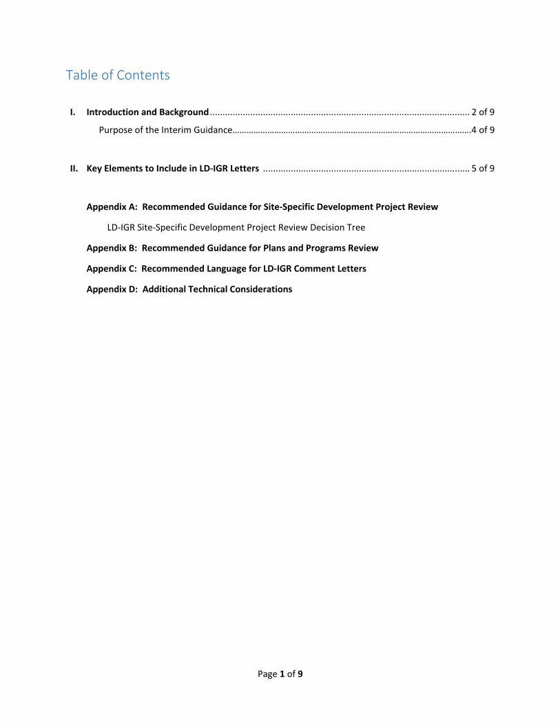
Table of Contents
I. Introduction and Background ....................................................................................................... 2 of 9
Purpose of the Interim Guidance………………………………………………………………………………………….4 of 9
II. Key Elements to Include in LD‐IGR Letters .................................................................................. 5 of 9
Appendix A: Recommended Guidance for Site‐Specific Development Project Review
LD‐IGR Site‐Specific Development Project Review Decision Tree
Appendix B: Recommended Guidance for Plans and Programs Review
Appendix C: Recommended Language for LD‐IGR Comment Letters
Appendix D: Additional Technical Considerations
Page 2 of 9
I. Introduction and Background
Caltrans’ Local Development‐Intergovernmental Review (LD‐IGR) program reviews land use and infrastructure plans and projects across the state for potential impacts and enhancements to the State’s environment, natural resources and multimodal transportation system for the California public. Through the LD‐IGR process, Caltrans advises Lead Agencies on what these impacts might be and ways to avoid, minimize, and/or mitigate adverse impacts. Caltrans also identifies land use and design strategies that may enhance connectivity and access to destinations. As required through a host of state and federal planning requirements, the LD‐IGR program has historically supported smart growth policies designed to create vibrant communities with a sustainable multimodal transportation system. For example, the program’s 2005 Deputy Directive 25‐R1 states:
“The Department works to ensure that local land use planning and development decisions include the provision of transportation choices, including transit, intercity rail passenger service, air service, walking, and biking, when appropriate. The Department advocates community design (e.g., urban infill, mixed use, transit oriented development) that promotes an efficient transportation system and healthy communities.”
With the enactment of legislation such as AB 32 (2006), SB 375 (2008), SB 226 (2011), SB 743 (2013), etc. and the development of planning guidance such as the Smart Mobility Framework, Complete Streets Implementation Action Plan, the California Transportation Plan 2040, as well as Caltrans’ adoption of its new mission, vision, goals and the Strategic Management Plan 2015 – 2020 (SMP), the LD‐IGR program is strengthening its focus on transportation infrastructure that supports smart growth and efficient development. This is intended to help ensure that greenhouse gas (GHG) emissions reduction, good community design, improved proximity to key destinations, and a safe, multimodal transportation system are all integral parts of land use decision making throughout the state. Past LD‐IGR practices primarily utilized Level of Service to identify various impacts to the State Highway System (SHS), and often limited its recommended mitigation to traditional road improvements. Although Caltrans recognized that Lead Agencies could implement other measures, such as improvements to other modes of transportation or incentive programs to encourage use of other modes, the Lead Agencies often rely on Caltrans’ recommended measures. Going forward, efforts to fulfill our LD‐IGR obligation should consider multimodal solutions to not only improve access to destinations for all system users (motorists, transit riders, bicyclists, pedestrians), but also encourage efficient land use that helps achieve the multitude of goals sought, including quality of life, economic prosperity, the development of multimodal networks, and GHG emissions reduction. The LD‐IGR program provides an important opportunity to encourage Lead Agencies to implement the goals and targets of the Caltrans Strategic Management Plan. By year 2020, the SMP calls for several specific targets related to the LD‐IGR program:
a doubling of walking and transit, and tripling of bicycle trips as a percentage of overall trips
a reduction of per capita vehicle miles traveled (VMT) by 15%
a reduction of the number of fatalities in each travel mode by 10% a year
a reduction of GHG and other pollutants consistent with the Air Resources Board’s AB 32 Scoping Plan and State Implementation Plan
an increase of freight system efficiency by 10 %
Page 3 of 9
a reduction to an 8% rate of growth in Daily Vehicle Hours of Delay (DVHD) under 35 miles per hour on urban State highways
The SMP also contains several strategic objectives related to the LD‐IGR program, including:
reduce user fatalities and injuries by adopting a “Toward Zero Deaths” practice
promote community health through active transportation and reduced pollution in communities
effectively manage taxpayer funds and maximize the use of available financial resources
improve the quality of life for all Californians by providing mobility choice, increasing accessibility to all modes of transportation and creating transportation corridors not only for conveyance of people, goods, and services, but also as livable public spaces
reduce environmental impacts from the transportation system with emphasis on supporting a statewide reduction of greenhouse gas emissions to achieve 80% below 1990 levels by 2050
improve economic prosperity of the State and local communities through a resilient and integrated transportation system
improve travel time reliability for all modes
reduce peak period travel times and delay for all modes through intelligent transportation systems, operational strategies, demand management, and land use/ transportation integration
increase the number of Complete Streets features on State highways that are also local streets in urban, suburban, and small town settings
improve collaborative partnerships with agencies, industries, municipalities and tribal governments and advance national engagement with the transportation research and policy committees
As highlighted in the guidance below, the LD‐IGR program’s revised approach to commenting on plans and projects will help meet the goals and targets of the Strategic Management Plan. One important component to help achieve these goals is Caltrans’ current process of creating a statewide Transportation Analysis Guide (TAG) and completing a comprehensive update of our Transportation Impact Study Guide (TISG). The TAG‐TISG will better inform transportation infrastructure investment and land use and infrastructure project impact analysis, bring Caltrans practices in line with state policy (including those policies named above), and bring Caltrans analysis practices up to state of the practice by providing a suite of methodologies, tools, and best practices. It will help public and private sector practitioners across the state perform the various types of analysis needed to identify multimodal transportation impacts from new land use, transportation, and infrastructure plans and projects.
In the interim, this Interim Guidance document intends to ensure that all Caltrans LD‐IGR comments on
growth plans, development projects, and infrastructure investments align with state policies through the
use of efficient development patterns, innovative demand reduction mitigation strategies, and necessary
multimodal roadway improvements. This is in addition to Caltrans’ long‐standing commitment to maintain
a safe, multimodal transportation system that provides access to destinations for all users. We also
continue to recognize that under the California Environmental Quality Act (CEQA), it is ultimately the Lead
Agency’s responsibility to perform a CEQA analysis, set local thresholds of significance, analyze potential
impacts, determine significance, and identify, implement, and monitor any required mitigations.
This guidance supersedes the 2002 Caltrans Guide for the Preparation of Traffic Impact Studies in comments to local agencies. Instead of referencing the 2002 guide, Districts should make specific analysis requests of the Lead Agency when additional information is needed. The District can offer to provide the Lead Agency assistance in developing the scope of any analysis and answering questions. Headquarters
Page 4 of 9
LD‐IGR staff is also able to assist with scoping required analysis and developing recommended solutions for the Districts’ and Caltrans’ local and regional partners to consider. In order to ensure alignment of Caltrans comments with state goals described above, LD‐IGR comments
henceforth should take into consideration whether the project exhibits low or high VMT (by place type
e.g., urban, suburban, and rural areas) and should focus recommendations on smart land use,
multimodal access, safety for all users, and reducing single occupant vehicle trips. Well planned urban
infill projects which are located close to transit, bike and pedestrian facilities (see Appendix A: Project
Type 1), which also have proximity benefits to employment centers, services and goods – will reduce
travel demand on the entire transportation system and will therefore require significantly less review
and mitigation than rural fringe projects (Project Type 5), which generate proportionately higher
number of trips and vehicle miles traveled.
Senate Bill 743 (2013) mandated that CEQA review of transportation impacts of proposed development
be modified by eliminating consideration of delay‐ and capacity‐ based metrics such as level of service
(LOS) and instead focusing analysis on another metric of impact. The Governor’s Office of Planning and
Research (OPR) is currently updating its CEQA Guidelines to implement SB 743 and is proposing that
vehicle miles traveled be the primary metric used in identifying transportation impacts. OPR has released
a separate “Technical Advisory” outlining recommended techniques for measuring impacts with this new
metric, which applies statewide. The General Plan Guidelines are also concurrently being updated to align
with state policy, including SB 743.
The need to evolve LD‐IGR comments on local development transportation analysis and local development mitigation responses was articulated in a California State Transportation Agency (CalSTA) commissioned review of Caltrans practices in the State Smart Transportation Initiative (SSTI). Their January 2014 report stated that “SB 743 could do more to advance state planning goals than anything else Caltrans has done”, and “would put California and Caltrans back at the leading edge of modern transportation practice ….. It would begin to make Caltrans a real contributor to the success of modern policy in the state, and it would provide a model for how the staff could help implement a challenging new charge.” A December 2014 report titled A Follow‐Up to The California Department of Transportation: SSTI Assessment and Recommendations noted that OPR, CalSTA and Caltrans have been collaborating closely on remaining CEQA rulemaking issues, such as “to manage operational challenges, namely where congested exit ramps may back up onto freeways, in a way that is not simply level of service by another name, failing to deliver the relief to infill development as the law directs. The draft rulemaking would also base mitigation on a development’s total vehicle‐miles generated.”
The TAG‐TISG will also help implement Caltrans Strategic Management Plan 2015‐2020 objectives consistent with SB 743 changes to CEQA. The TAG‐TISG focuses transportation analysis on VMT impacts, assessing impacts from growth plans and development projects on the multimodal transportation network, and quantifying VMT and GHG reductions achieved through smart mobility principles and Transportation Demand Management (TDM) strategies. Until the TAG‐TISG is complete, the Interim Guidance provided herein is intended to help ensure that District LD‐IGR comment letters evolve to carry out state law, reflect the State’s strategic safety goals and planning priorities, and align with California’s climate change goals.
Purpose of this Interim Guidance
Page 5 of 9
With the Strategic Management Plan objectives and SB 743’s changes to CEQA, LD‐IGR coordinators and functional reviewers will transition away from using delay based analysis, such as LOS or similar measures of vehicular capacity or traffic congestion, to determine the impacts of land use and infrastructure plans and projects. Instead, they will identify opportunities for reduced VMT generation, advise Lead Agencies on maintaining safe operations, and provide recommendations on developing location‐efficient (e.g., centrally located, infill) and travel‐efficient (e.g., inclusion of TDM measures) land use. This Interim Guidance will remain in effect until superseded by Caltrans Transportation Impact Study Guidelines (TISG), currently under development. Henceforth, LD‐IGR comment letters should reflect the “top six” elements discussed below, as well as the more detailed guidance in the accompanying appendices. It is important to note that this Interim Guidance is intended to be the overarching policy and guidance of the LD‐IGR program, aside from any Director’s Policies or Deputy Directives. The Headquarters LD‐IGR program will be updating guidance and training to be aligned with the Strategic Management Plan 2015‐2020 lens over the upcoming months. If reviewers notice any discrepancies in policy and direction between the existing guidance on the Caltrans intranet and this Interim Guidance, please notify the LD‐IGR program manager for further direction. Similarly, if reviewers experience any difficulties in applying this Interim Guidance to individual development‐related plans, programs, or projects, they are encouraged to contact Alyssa Begley, SB 743 Program Implementation Manager, for assistance on a statewide perspective, and suggested solutions that might be useful.
Active participation by the Districts in regularly scheduled LD‐IGR Teleforum meetings with Headquarters will also help District staff keep abreast of emerging methodologies, relevant examples, and current events that may further inform this Interim Guidance while OPR’s CEQA Guidelines Update and Caltrans’ TAG‐TISG Update are in progress.
The existing LD‐IGR program’s intranet guidance and the technical resources are found at: http://transplanning.onramp.dot.ca.gov/local‐development‐intergovernmental‐review‐ld‐igr‐branch
II. Key Elements to Include in LD‐IGR Letters
This section summarizes the “top six” elements to emphasize when reviewing development plans and project proposals for transportation impacts and when drafting LD‐IGR comment letters. The following appendices provide explicit guidance, technical considerations, and template language for District LD‐IGR coordinators and functional reviewers to incorporate as needed. A. Comment on Vehicle Miles Traveled associated with the project. Reviewers should comment on vehicle miles traveled resulting from the land use project, applying local agency thresholds or absent those, thresholds recommended by the most recent draft of OPR’s CEQA Guidelines and Technical Advisory. If an assessment of VMT is not presented, Caltrans should request it be presented. Though SB 743 clarifies requirements for transportation analysis, a VMT analysis is already
Page 6 of 9
needed to meet other CEQA requirements.1 Methods for assessing VMT should be compared to the methods recommended in the OPR Technical Advisory. Where methods are not consistent with the recommendations in the Technical Advisory, Caltrans should comment on those methods. Where the project exhibits less than threshold VMT, Caltrans comments should acknowledge the project’s transportation efficiency. Where the project exhibits greater than threshold VMT, Caltrans should request mitigation. Examples of mitigation measures are included in the OPR Technical Advisory. Contact the SB 743 Program Implementation Manager, Alyssa Begley, for assistance with VMT calculation.
B. Rather than providing recommendations that primarily accommodate motor vehicle travel, provide recommendations that strive to reduce VMT generation; improve pedestrian, bike, and transit service and infrastructure; and which don’t induce additional VMT.
As demonstrated by the template language provided in Appendix C of this Interim Guidance, it is important that Caltrans comment letters express the intent and purpose of the LD‐IGR program and Caltrans’ review of land use and infrastructure plans and projects through the new lens of the Caltrans Strategic Management Plan 2015‐2020. In other words, providing recommendations for solutions that reduce automobile travel rather than recommendations that accommodate more of it. For example, consider the following sample paragraph intended for letter introductions:
“The mission of Caltrans is to provide a safe, sustainable, integrated, and efficient transportation system to enhance California’s economy and livability. The Local Development‐Intergovernmental Review (LD‐IGR) Program reviews land use and infrastructure plans and projects through the lenses of our mission, vision, and goals as guided by the State’s planning priorities of prioritizing infill, conservation, and efficient development.”
Consider also the following paragraph intended to discuss demand reduction and mitigation strategies:
“Caltrans seeks to reduce vehicle trips and new vehicle miles traveled associated with development and recommends appropriate measures to avoid, minimize, or mitigate transportation impacts through smart mobility community design and innovative multimodal demand reduction strategies.”
C. Focus on travel efficiency
Coordinators and reviewers should use the terms “transportation impact study” rather than “traffic impact study” and note that the study should analyze all modes. Such terminology helps developers, decision makers, and the public better understand that Caltrans seeks a holistic perspective on the infrastructure (roadways, bicycle facilities, sidewalks, transit stations, etc.), the service (e.g. transit, rail, etc.) needs, opportunities for closer proximity to key destinations, and other factors that may be created by growth plans and development projects under review. This language acknowledges and builds upon the multimodal perspective taken by the LD‐IGR program since its inception, but not always followed in practice. This approach will also help shape the analysis techniques applied to the review so that the right kinds of data and analyses are provided for consideration. For example, Districts should help the Lead Agency contextualize the project by describing not just what and where it is, but also
1 See CEQA Guidelines §15064.4 (analysis of greenhouse gas emissions) and Appendix F (requiring analysis of “the project’s projected transportation energy use requirements and its overall use of efficient transportation alternatives”. See also California Clean Energy Committee v. City of Woodland (2014) 225 Cal. App. 4th 173, 210.
Page 7 of 9
how those factors relate to both the multimodal transportation system and parallel objectives such as job creation, resource and open space conservation, or housing affordability—especially for projects and plans that generate high VMT. If the project is on the suburban edge of a region or far from transit, it is likely to induce more VMT than an infill project. In assessing how the project might be able to reduce its VMT generation, it is also critical to understand how the project can enhance a multimodal transportation network, how the project may increase access to key destinations (by foot or bicycle), and what aspects of the system can be utilized as feasible TDM mitigation measures. See Appendix D for additional information.
Districts should be cognizant of land use economics when reviewing local development projects in order
to be mindful of all factors that lead to viability of individual project, more specifically, for projects that
generate less overall vehicle miles traveled.
Districts are strongly encouraged to work with Lead Agencies to address transportation deficiencies and enhancements through policies at the planning level and through mitigation fee programs. Districts should still encourage Lead Agencies to share plans and projects for review that directly abut the SHS, are in vicinity of a State Highway, or projects for which Caltrans must approve and issue an encroachment permit. Headquarters LD‐IGR staff recognizes that this type of analysis will be a dramatic shift in process for Caltrans, and that Headquarters programs, District coordinators, and functional reviewers will need extensive training to adapt to the new analysis methods. Headquarters LD‐IGR staff will coordinate with the Districts to ensure additional training and tools are provided throughout the Department. If Districts have training requests or concerns, please contact their Headquarters LD‐IGR coordinator.
D. Remain neutral on project purpose while framing recommendations for mitigation of the project’s impacts within statewide policy.
Commenting on local development can be controversial and should be written in a tone that promotes partnership, promotes collaboration, focuses on technical aspects of plans and projects, and is deferential to the Lead Agency’s discretionary authority. However, Caltrans has a responsibility to advance the state’s legislative priorities and carry out its role as a Responsible or Commenting Agency under CEQA. In order to strike this balance, our response letters should convey Caltrans’ desire to be an active partner in Lead Agencies understand the transportation implications of development and to assist Lead Agencies in shaping projects to make more efficient use of our transportation system. Districts may choose to, for example:
State whether the project is location‐efficient (e.g. transit‐oriented infill), with safe and adequate access to a multimodal transportation system and key destinations, that will help the state meet its GHG reduction targets under AB 32; or if it is sprawl that will increase VMT and regional emissions. As described in Section A above, ascertain VMT per OPR’s guidance. Residential development should be assessed on a per capita basis. Office development VMT should be assessed on a per employee basis. Retail project VMT should be assessed on an absolute basis, but need not be calculated for local‐serving retail (which generally reduces VMT). Land use project VMT should be compared to thresholds created by the local agency. In the absence of local agency thresholds, use recommendations in OPR’s Technical Advisory, i.e., 15 percent below overall regional or city VMT per capita for residential projects, 15 percent below regional VMT per employee for office projects, and any increase in overall VMT for retail (further details can be
Page 8 of 9
found in the Technical Advisory). For residential and office development, VMT Maps produced by either regional travel demand models, or the California Statewide Travel Demand Model may be used as a shortcut to estimating VMT. VMT Calculation training will be made available to District staff. Sample language is provided in Appendix C.
Note if the project is consistent or inconsistent with the growth patterns and future infrastructure features identified in the General Plan or Master‐Specific Plans, as well as Regional Transportation Plans (RTP) or Sustainable Community Strategies (SCSs).
Note if the project is consistent or inconsistent with State planning priorities of infill, conservation, and efficient development. For more information on the State’s planning priorities, see the text from AB 857 (2002) and SB 226 (2011).
While it is not necessary to “take a stand” by commenting on a Lead Agency’s actual decision to adopt a plan or approve‐deny a project, comment letters should express findings of consistency or concern related to the implications and impacts, particularly VMT impacts, of development projects. And remember, Caltrans can recommend plan changes or project re‐design where impact avoidance or minimization could be achieved. For example, a high‐VMT‐inducing edge development may consider walking or biking connectivity around a new major transit station with high‐quality transit service (see SB 375), or if such a transit station is not present or planned, then around a neighborhood town center. Similarly, a jurisdiction or developer might be able to take advantage of reduced parking requirements or affordability density‐bonus credits for projects located in infill areas to achieve a more efficient growth pattern. Such suggestions can point to a “win‐win” by substantially reducing the plan’s or project’s VMT generation while still meeting the developer and Lead Agency’s overarching economic and community development objectives. Our comment letters should note when Caltrans has had discussions in person with Lead Agency staff.
E. Be collaborative – Create paths for workable solutions and overcome roadblocks.
Cities, counties, and developers, as well as Regional Transportation Planning Agencies (RTPAs), Metropolitan Planning Organizations (MPOs), transit and inner‐city rail operators, and a wide array of employers and service providers across the State face increasing pressures to accommodate California’s population growth with limited funding, while also facing environmental and community‐acceptance constraints. Caltrans, through our LD‐IGR role, can work collaboratively to assist these agencies. Comment letters should not just identify potential concerns or problems, but offer suggested solutions that could be taken toward their resolution. District staff should proactively establish early consultation in the planning and development project process. For example, request face‐to‐face meetings with Lead Agencies and project proponents to discuss how state law and the multimodal policies in city/county General Plans and RTPA/MPO RTPs and SCSs apply to the development project being reviewed or plan amendments being considered. This would allow both plan‐level and project‐specific technical concerns to be conveyed and, if possible, resolved with Lead Agencies as part of on‐going information sharing. Such meetings can be used to link “early” and “late” steps in the development approval process by identifying potential planning policies and avoidance or minimization strategies, and developing mitigation implementation programs that help achieve Caltrans Strategic Management Plan 2015‐2020 objectives and other state goals. Specifically, Districts should perform robust review of the land use and transportation analysis contained in the transportation impact studies for the environmental impact reports performed on General Plans, Specific/Master/Community plans, Regional Transportation Plans, Sustainable Community Strategies, etc.. This affords District staff a better
Page 9 of 9
understanding of how individual “streamlined” developments and infrastructure investments “tier” off of the analysis in plan‐ or program‐level EIRs and provides opportunities for Caltrans to encourage and help shape new VMT‐based impact fees.
F. Comments related to impacts to the State Highway System (SHS) will be focused on VMT impacts not delay or effects on road capacity.
Transportation analysis under CEQA is evolving, in part because of SB 743, to measure impacts using vehicle miles traveled. Similarly, Caltrans has adopted Strategic Management Plan goals related to reducing VMT per capita and increasing use of non‐auto modes. Therefore, in reviewing project proposals and related CEQA documents, LD‐IGR will focus its comments on reducing demand on the SHS as measured with VMT. Caltrans continues to be responsible for ensuring that encroachments on or changes to the SHS are designed to provide for safe operations. The use of LOS as a CEQA threshold of significance will soon be disallowed and replaced with vehicle miles traveled. SB 743 did not alter a Lead Agency’s responsibility to “analyze a project’s potentially significant transportation impacts related to air quality, noise, safety, or any other impact associated with transportation.”2 Any information requests should be consistent with the guidance found in Appendices A and B. This section will not address specifics of how to conduct an operational impacts analysis for all modes of transportation. This section is focused on the general policy, tone, and approach. Improvements on conventional roadways should, as appropriate to the context, emphasize a complete streets approach to improvements (improvements such as lane width reduction, landscaped medians, pedestrian bulb outs, etc.) and should avoid increasing automobile capacity and/or other measures that would significantly increase VMT. Suggested improvements to address operational impacts should not result in increased speeds that are not suitable for vulnerable users on the conventional facility. Operational impact improvements should be appropriate to the context and consistent with complete streets principles wherever feasible. Capacity improvements to freeway ramps and freeway mainlines to address operational impacts should be a last resort. Improved crosswalk signal timing, intelligent transportation systems improvements, enhanced signage, roadway designs that result in reduced speed limits, and other effective methods that do not significantly increase VMT should first be explored as potential solutions.
2 A safety‐related transportation impact under CEQA is not the same as, and does not establish, an unsafe condition. Instead, the CEQA determinations are based on modeling and projections of potential future conditions and any mitigation is focused on making conditions safer.
Please use this flow chart and the guidance following it to determine whether to comment on site‐specific projects and what types of comments to make based on the type of project and its location. Reviewers should first consider the project’s geographic setting and whether projects are located in an infill location, have a walkable project design, and assess VMT generation (definitions of key terms are at the end of this appendix). Projects may not fall perfectly into the place type categories below, so please use your best judgment on types of comments to make. We recognize every project is different.
Before sending a comment letter, the District LD‐IGR coordinator should consider what the main objective of sending a letter is, what point of the process the project is in, and if it is necessary to even make comments. A request for additional analysis should be followed by an explanation of why that analysis is needed. If we request a Lead Agency to provide additional analysis on how a project impacts the SHS, we should articulate our concerns. Districts should not just ask for studies or analysis for projects just to have the information. For high‐VMT projects, comments should have a primary focus on helping a project reduce VMT loaded onto roadway networks, including the State Highway System.
Appendix A: Recommended Guidance for Site‐Specific Development Project Review
1
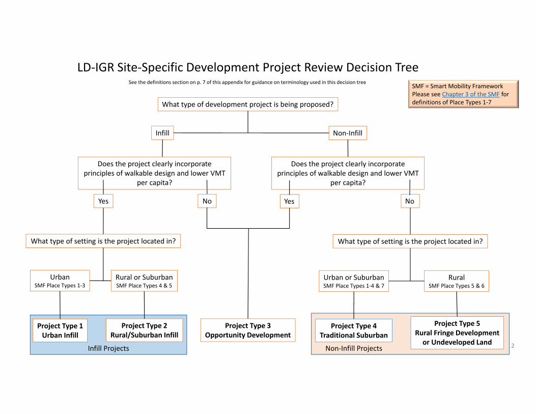
What type of development project is being proposed?
What type of setting is the project located in?
UrbanSMF Place Types 1‐3
Rural or SuburbanSMF Place Types 4 & 5
Project Type 1Urban Infill
Project Type 2Rural/Suburban Infill
Urban or SuburbanSMF Place Types 1‐4 & 7
RuralSMF Place Types 5 & 6
Project Type 3Opportunity Development
Project Type 4Traditional Suburban
Project Type 5Rural Fringe Development or Undeveloped Land
Infill Non‐Infill
Infill Projects Non‐Infill Projects
LD‐IGR Site‐Specific Development Project Review Decision TreeSee the definitions section on p. 7 of this appendix for guidance on terminology used in this decision tree
SMF = Smart Mobility FrameworkPlease see Chapter 3 of the SMF for definitions of Place Types 1‐7
2
Does the project clearly incorporate principles of walkable design and lower VMT
per capita?
Yes YesNo No
Does the project clearly incorporate principles of walkable design and lower VMT
per capita?
What type of setting is the project located in?
Urban Infill
Project Type 1
Rural/Suburban Infill
Project Type 2
Opportunity Development
Project Type 3
Traditional SuburbanProject Type 4
Rural Fringe/ Undeveloped LandProject Type 5
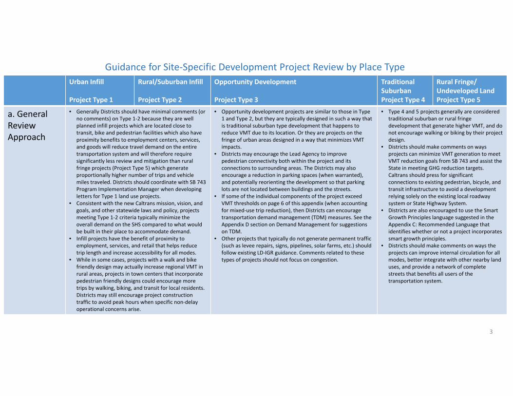
a. General Review Approach
• Generally Districts should have minimal comments (or no comments) on Type 1‐2 because they are well planned infill projects which are located close to transit, bike and pedestrian facilities which also have proximity benefits to employment centers, services, and goods will reduce travel demand on the entire transportation system and will therefore require significantly less review and mitigation than rural fringe projects (Project Type 5) which generate proportionally higher number of trips and vehicle miles traveled. Districts should coordinate with SB 743 Program Implementation Manager when developing letters for Type 1 land use projects.
• Consistent with the new Caltrans mission, vision, and goals, and other statewide laws and policy, projects meeting Type 1‐2 criteria typically minimize the overall demand on the SHS compared to what would be built in their place to accommodate demand.
• Infill projects have the benefit of proximity to employment, services, and retail that helps reduce trip length and increase accessibility for all modes.
• While in some cases, projects with a walk and bike friendly design may actually increase regional VMT in rural areas, projects in town centers that incorporate pedestrian friendly designs could encourage more trips by walking, biking, and transit for local residents. Districts may still encourage project construction traffic to avoid peak hours when specific non‐delayoperational concerns arise.
• Opportunity development projects are similar to those in Type 1 and Type 2, but they are typically designed in such a way that is traditional suburban type development that happens to reduce VMT due to its location. Or they are projects on the fringe of urban areas designed in a way that minimizes VMT impacts.
• Districts may encourage the Lead Agency to improve pedestrian connectivity both within the project and its connections to surrounding areas. The Districts may also encourage a reduction in parking spaces (when warranted), and potentially reorienting the development so that parking lots are not located between buildings and the streets.
• If some of the individual components of the project exceed VMT thresholds on page 6 of this appendix (when accounting for mixed‐use trip reduction), then Districts can encourage transportation demand management (TDM) measures. See the Appendix D section on Demand Management for suggestions on TDM.
• Other projects that typically do not generate permanent traffic (such as levee repairs, signs, pipelines, solar farms, etc.) should follow existing LD‐IGR guidance. Comments related to these types of projects should not focus on congestion.
• Type 4 and 5 projects generally are considered traditional suburban or rural fringe development that generate higher VMT, and do not encourage walking or biking by their project design.
• Districts should make comments on ways projects can minimize VMT generation to meet VMT reduction goals from SB 743 and assist the State in meeting GHG reduction targets. Caltrans should press for significant connections to existing pedestrian, bicycle, and transit infrastructure to avoid a development relying solely on the existing local roadway system or State Highway System.
• Districts are also encouraged to use the SmartGrowth Principles language suggested in the Appendix C: Recommended Language that identifies whether or not a project incorporates smart growth principles.
• Districts should make comments on ways the projects can improve internal circulation for all modes, better integrate with other nearby land uses, and provide a network of complete streets that benefits all users of the transportation system.
Guidance for Site‐Specific Development Project Review by Place Type
3
Urban Infill
Project Type 1
Rural/ Suburban InfillProject Type 2
OpportunityDevelopmentProject Type 3
Traditional SuburbanProject Type 4
Rural Fringe/ Undeveloped LandProject Type 5
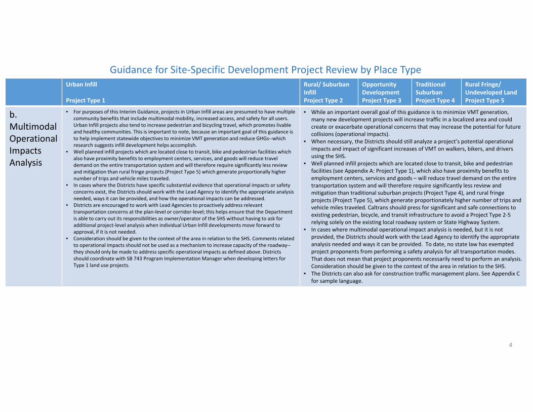
b. Multimodal Operational Impacts Analysis
• For purposes of this Interim Guidance, projects in Urban Infill areas are presumed to have multiple community benefits that include multimodal mobility, increased access, and safety for all users. Urban Infill projects also tend to increase pedestrian and bicycling travel, which promotes livable and healthy communities. This is important to note, because an important goal of this guidance is to help implement statewide objectives to minimize VMT generation and reduce GHGs‐‐which research suggests infill development helps accomplish.
• Well planned infill projects which are located close to transit, bike and pedestrian facilities which also have proximity benefits to employment centers, services, and goods will reduce travel demand on the entire transportation system and will therefore require significantly less review and mitigation than rural fringe projects (Project Type 5) which generate proportionally higher number of trips and vehicle miles traveled.
• In cases where the Districts have specific substantial evidence that operational impacts or safety concerns exist, the Districts should work with the Lead Agency to identify the appropriate analysis needed, ways it can be provided, and how the operational impacts can be addressed.
• Districts are encouraged to work with Lead Agencies to proactively address relevant transportation concerns at the plan‐level or corridor‐level; this helps ensure that the Department is able to carry out its responsibilities as owner/operator of the SHS without having to ask for additional project‐level analysis when individual Urban Infill developments move forward to approval, if it is not needed.
• Consideration should be given to the context of the area in relation to the SHS. Comments related to operational impacts should not be used as a mechanism to increase capacity of the roadway‐‐they should only be made to address specific operational impacts as defined above. Districts should coordinate with SB 743 Program Implementation Manager when developing letters for Type 1 land use projects.
• While an important overall goal of this guidance is to minimize VMT generation, many new development projects will increase traffic in a localized area and could create or exacerbate operational concerns that may increase the potential for future collisions (operational impacts).
• When necessary, the Districts should still analyze a project’s potential operational impacts and impact of significant increases of VMT on walkers, bikers, and drivers using the SHS.
• Well planned infill projects which are located close to transit, bike and pedestrian facilities (see Appendix A: Project Type 1), which also have proximity benefits to employment centers, services and goods – will reduce travel demand on the entire transportation system and will therefore require significantly less review and mitigation than traditional suburban projects (Project Type 4), and rural fringe projects (Project Type 5), which generate proportionately higher number of trips and vehicle miles traveled. Caltrans should press for significant and safe connections to existing pedestrian, bicycle, and transit infrastructure to avoid a Project Type 2‐5 relying solely on the existing local roadway system or State Highway System.
• In cases where multimodal operational impact analysis is needed, but it is not provided, the Districts should work with the Lead Agency to identify the appropriate analysis needed and ways it can be provided. To date, no state law has exempted project proponents from performing a safety analysis for all transportation modes. That does not mean that project proponents necessarily need to perform an analysis. Consideration should be given to the context of the area in relation to the SHS.
• The Districts can also ask for construction traffic management plans. See Appendix C for sample language.
Guidance for Site‐Specific Development Project Review by Place Type
4
Urban Infill
Project Type 1
Rural/Suburban Infill
Project Type 2
Opportunity Development
Project Type 3
Traditional Suburban
Project Type 4
Rural Fringe/ Undeveloped LandProject Type 5
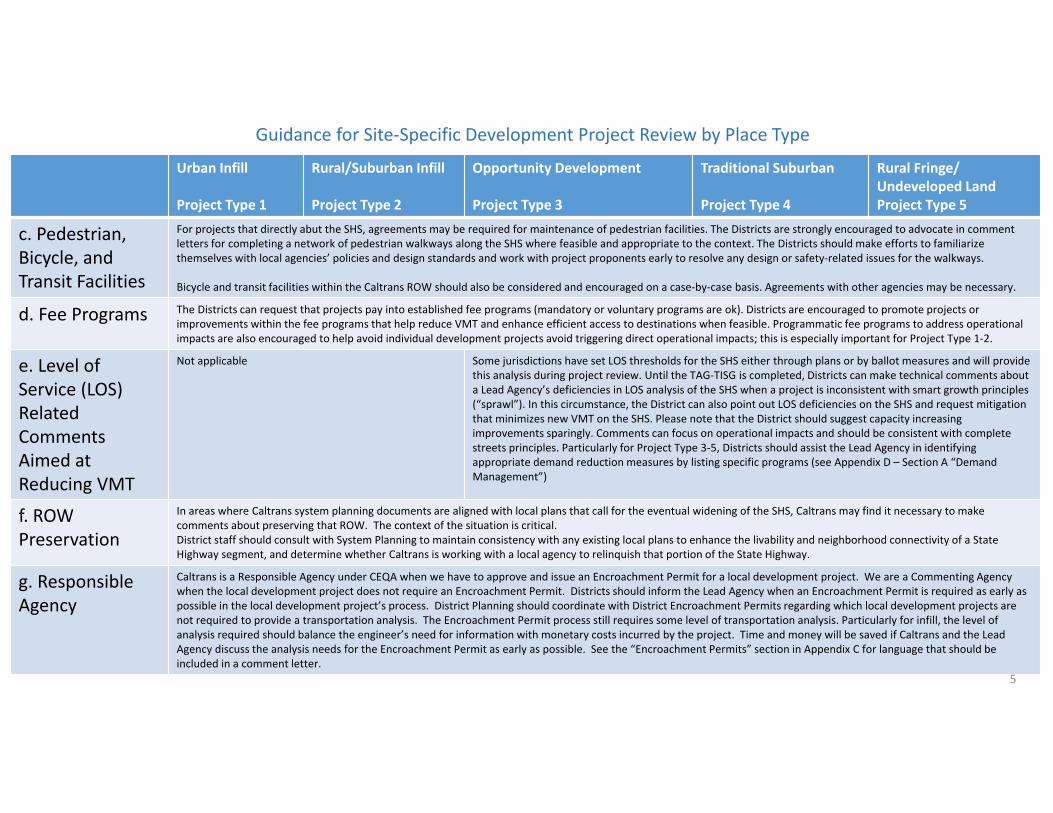
c. Pedestrian, Bicycle, and Transit Facilities
For projects that directly abut the SHS, agreements may be required for maintenance of pedestrian facilities. The Districts are strongly encouraged to advocate in comment letters for completing a network of pedestrian walkways along the SHS where feasible and appropriate to the context. The Districts should make efforts to familiarize themselves with local agencies’ policies and design standards and work with project proponents early to resolve any design or safety‐related issues for the walkways.
Bicycle and transit facilities within the Caltrans ROW should also be considered and encouraged on a case‐by‐case basis. Agreements with other agencies may be necessary.
d. Fee Programs The Districts can request that projects pay into established fee programs (mandatory or voluntary programs are ok). Districts are encouraged to promote projects or improvements within the fee programs that help reduce VMT and enhance efficient access to destinations when feasible. Programmatic fee programs to address operational impacts are also encouraged to help avoid individual development projects avoid triggering direct operational impacts; this is especially important for Project Type 1‐2.
e. Level of Service (LOS) Related Comments Aimed at Reducing VMT
Not applicable Some jurisdictions have set LOS thresholds for the SHS either through plans or by ballot measures and will provide this analysis during project review. Until the TAG‐TISG is completed, Districts can make technical comments about a Lead Agency’s deficiencies in LOS analysis of the SHS when a project is inconsistent with smart growth principles (“sprawl”). In this circumstance, the District can also point out LOS deficiencies on the SHS and request mitigation that minimizes new VMT on the SHS. Please note that the District should suggest capacity increasing improvements sparingly. Comments can focus on operational impacts and should be consistent with complete streets principles. Particularly for Project Type 3‐5, Districts should assist the Lead Agency in identifying appropriate demand reduction measures by listing specific programs (see Appendix D – Section A “Demand Management”)
f. ROW Preservation
In areas where Caltrans system planning documents are aligned with local plans that call for the eventual widening of the SHS, Caltrans may find it necessary to makecomments about preserving that ROW. The context of the situation is critical.District staff should consult with System Planning to maintain consistency with any existing local plans to enhance the livability and neighborhood connectivity of a State Highway segment, and determine whether Caltrans is working with a local agency to relinquish that portion of the State Highway.
g. Responsible Agency
Caltrans is a Responsible Agency under CEQA when we have to approve and issue an Encroachment Permit for a local development project. We are a Commenting Agency when the local development project does not require an Encroachment Permit. Districts should inform the Lead Agency when an Encroachment Permit is required as early as possible in the local development project’s process. District Planning should coordinate with District Encroachment Permits regarding which local development projects are not required to provide a transportation analysis. The Encroachment Permit process still requires some level of transportation analysis. Particularly for infill, the level of analysis required should balance the engineer’s need for information with monetary costs incurred by the project. Time and money will be saved if Caltrans and the Lead Agency discuss the analysis needs for the Encroachment Permit as early as possible. See the “Encroachment Permits” section in Appendix C for language that should be included in a comment letter.
Guidance for Site‐Specific Development Project Review by Place Type
5
Urban Infill
Project Type 1
Rural/Suburban Infill
Project Type 2
Opportunity Development
Project Type 3
Traditional Suburban
Project Type 4
Rural Fringe/ Undeveloped LandProject Type 5
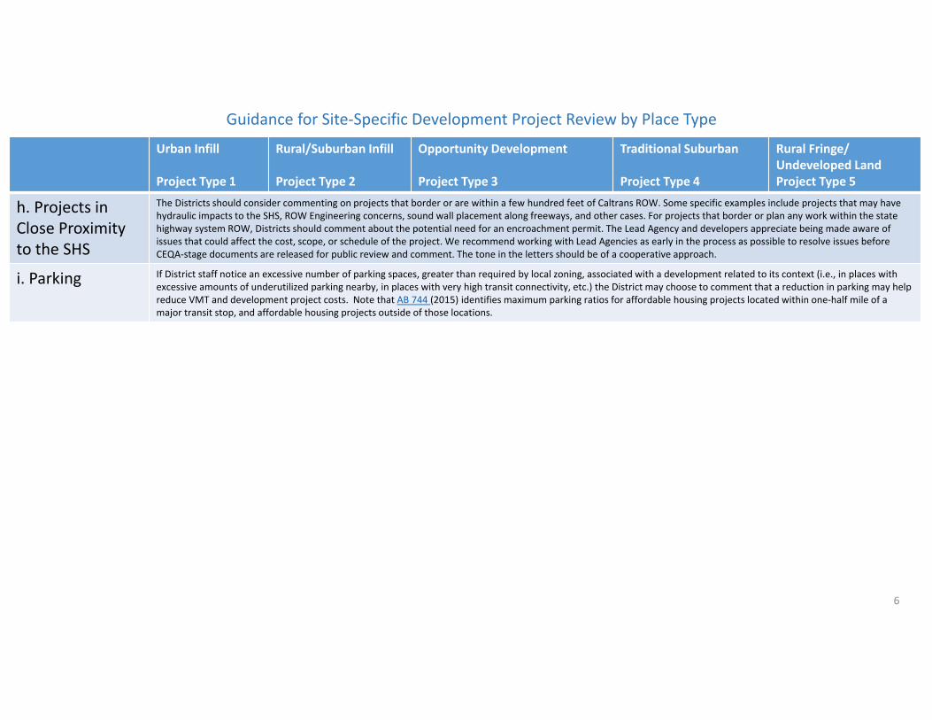
h. Projects in Close Proximity to the SHS
The Districts should consider commenting on projects that border or are within a few hundred feet of Caltrans ROW. Some specific examples include projects that may have hydraulic impacts to the SHS, ROW Engineering concerns, sound wall placement along freeways, and other cases. For projects that border or plan any work within the state highway system ROW, Districts should comment about the potential need for an encroachment permit. The Lead Agency and developers appreciate being made aware of issues that could affect the cost, scope, or schedule of the project. We recommend working with Lead Agencies as early in the process as possible to resolve issues before CEQA‐stage documents are released for public review and comment. The tone in the letters should be of a cooperative approach.
i. Parking If District staff notice an excessive number of parking spaces, greater than required by local zoning, associated with a development related to its context (i.e., in places with excessive amounts of underutilized parking nearby, in places with very high transit connectivity, etc.) the District may choose to comment that a reduction in parking may help reduce VMT and development project costs. Note that AB 744 (2015) identifies maximum parking ratios for affordable housing projects located within one‐half mile of a major transit stop, and affordable housing projects outside of those locations.
Guidance for Site‐Specific Development Project Review by Place Type
6
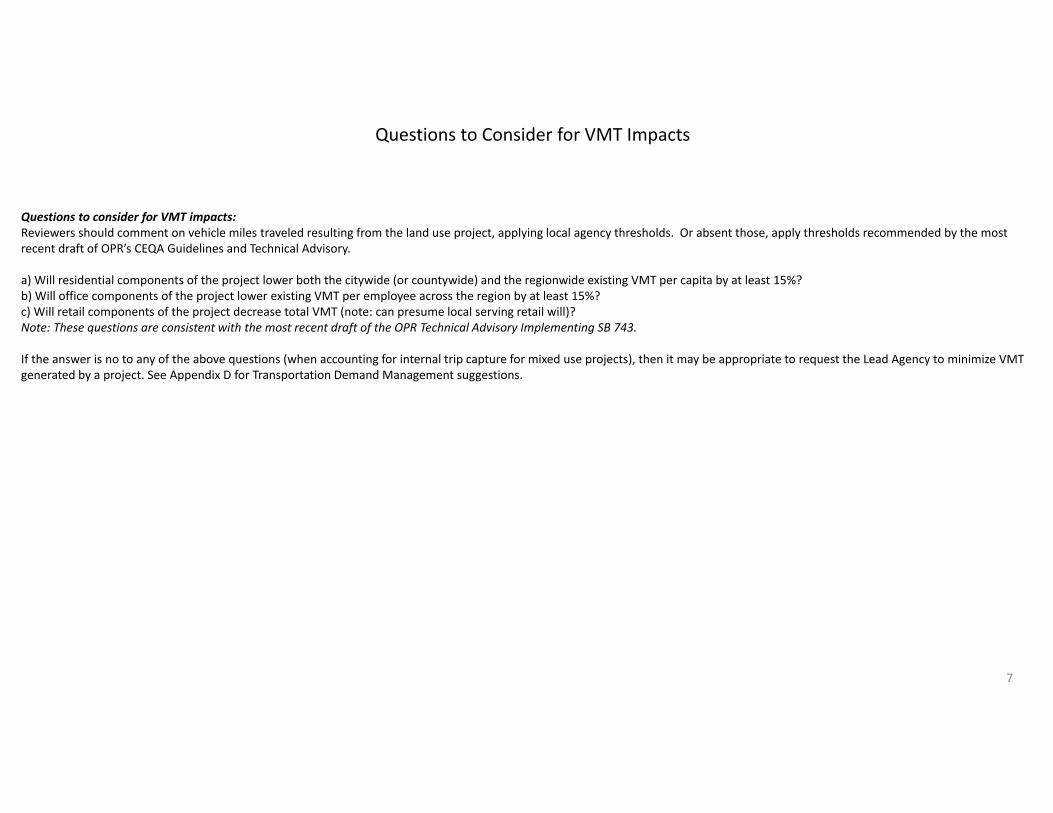
Questions to consider for VMT impacts:Reviewers should comment on vehicle miles traveled resulting from the land use project, applying local agency thresholds. Or absent those, apply thresholds recommended by the most recent draft of OPR’s CEQA Guidelines and Technical Advisory.
a) Will residential components of the project lower both the citywide (or countywide) and the regionwide existing VMT per capita by at least 15%? b) Will office components of the project lower existing VMT per employee across the region by at least 15%? c) Will retail components of the project decrease total VMT (note: can presume local serving retail will)?Note: These questions are consistent with the most recent draft of the OPR Technical Advisory Implementing SB 743.
If the answer is no to any of the above questions (when accounting for internal trip capture for mixed use projects), then it may be appropriate to request the Lead Agency to minimize VMT generated by a project. See Appendix D for Transportation Demand Management suggestions.
7
Questions to Consider for VMT Impacts
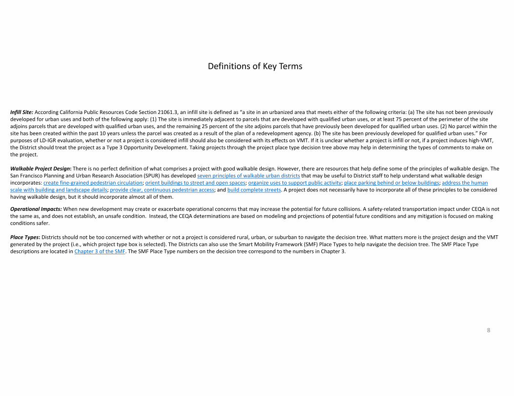
Infill Site: According California Public Resources Code Section 21061.3, an infill site is defined as “a site in an urbanized area that meets either of the following criteria: (a) The site has not been previously developed for urban uses and both of the following apply: (1) The site is immediately adjacent to parcels that are developed with qualified urban uses, or at least 75 percent of the perimeter of the site adjoins parcels that are developed with qualified urban uses, and the remaining 25 percent of the site adjoins parcels that have previously been developed for qualified urban uses. (2) No parcel within the site has been created within the past 10 years unless the parcel was created as a result of the plan of a redevelopment agency. (b) The site has been previously developed for qualified urban uses.” For purposes of LD‐IGR evaluation, whether or not a project is considered infill should also be considered with its effects on VMT. If it is unclear whether a project is infill or not, if a project induces high‐VMT, the District should treat the project as a Type 3 Opportunity Development. Taking projects through the project place type decision tree above may help in determining the types of comments to make on the project.
Walkable Project Design: There is no perfect definition of what comprises a project with good walkable design. However, there are resources that help define some of the principles of walkable design. The San Francisco Planning and Urban Research Association (SPUR) has developed seven principles of walkable urban districts that may be useful to District staff to help understand what walkable design incorporates: create fine‐grained pedestrian circulation; orient buildings to street and open spaces; organize uses to support public activity; place parking behind or below buildings; address the human scale with building and landscape details; provide clear, continuous pedestrian access; and build complete streets. A project does not necessarily have to incorporate all of these principles to be considered having walkable design, but it should incorporate almost all of them.
Operational Impacts: When new development may create or exacerbate operational concerns that may increase the potential for future collisions. A safety‐related transportation impact under CEQA is not the same as, and does not establish, an unsafe condition. Instead, the CEQA determinations are based on modeling and projections of potential future conditions and any mitigation is focused on making conditions safer.
Place Types: Districts should not be too concerned with whether or not a project is considered rural, urban, or suburban to navigate the decision tree. What matters more is the project design and the VMT generated by the project (i.e., which project type box is selected). The Districts can also use the Smart Mobility Framework (SMF) Place Types to help navigate the decision tree. The SMF Place Type descriptions are located in Chapter 3 of the SMF. The SMF Place Type numbers on the decision tree correspond to the numbers in Chapter 3.
Definitions of Key Terms
8
Appendix B Page 1 of 3
Appendix B: Recommended Guidance for Plans and Programs Review
There are many different types of plans (General, Specific, Community, Regional Transportation, Watershed, Air Quality to name a few) and programs that LD‐IGR reviewers receive. To cover all the different types of them would defeat the purpose of keeping this guidance brief and just providing an overall policy framework. OPR’s Technical Advisory provides guidance on VMT‐based impact analysis and mitigation. An array of research is available on this topic, much of which is summarized and packaged for deployment in the California Air Pollution Control Officers Association (CAPCOA) Quantifying Greenhouse Gas Mitigation Measures document (which focuses also on VMT). Further, HQ will post Technical Bulletins on Onramp as further information becomes available. In the meantime, HQ will provide the Districts with an SB 743 notification letter template for transmittal to Lead Agencies explaining what SB 743 requires them to consider, noting how Caltrans can assist, and stating that OPR is drafting an update of its CEQA Guidelines in order to spell out the new requirements in more detail. It is important to note that one of the likely outcomes of SB 743 implementation will be the closer alignment of project‐specific impact analysis and mitigation with the regional growth and program‐level management strategies identified through the regional and systems planning process. Through regional and system planning efforts, the existing transportation system is analyzed and future improvements are planned to improve human mobility and system operations based on the regional population growth and mobility needs identified through city and county General Plans, RTPs/MTPs, etc. For example, when District system planners update Transportation Concept Reports (TCR), District System Management Plans (DSMPs), and Corridor System Management Plans (CSMP), coordination with LD‐IGR is an opportunity to reflect long range growth plans, development projects, and regional improvement plans identified in regional planning documents. Similarly, when LD‐IGR coordinators are reviewing development plans and projects, coordination with regional and system planning can be used to identify ultimate ROW setbacks, access management restrictions, planned frontage improvements, and facility improvements identified in system planning documents that should be factored into a project’s site plan and mitigation measures. Particularly at a project level, we want to avoid disadvantaging the last‐in development. Caltrans (as well as other agencies) is sometimes criticized for being a barrier to local infill development by asking for costly studies or mitigation. In order to achieve equity in transportation financing and not place unreasonable burdens on site‐specific development projects that advance state goals of smart growth and reduced greenhouse gas emissions, Caltrans should work with Lead Agencies to address impacts to the SHS at the plan level and in fee programs. In general, plans and programs can be an extremely important and efficient mechanism to identify and mitigate issues at a macro level and thus avoid issues with the site‐specific project analysis. VMT reduction can have substantial safety benefits, so Districts should emphasize VMT reduction in their comments on lead agency plans or programs. One way Districts can work with their partners to address mitigation issues is to proactively and directly participate in the development of comprehensive plans (e.g. General Plans, Master Plans, Specific Plans, etc.) and mitigation implementation programs (regional advance mitigation programs, impact fee nexus plans and capital improvement plans, etc.). For instance, a local agency could forecast expected development, identify needed transportation improvements that provides safe access for all modes (like lowering speeds at interchanges, mid‐block crossings for pedestrians, cycle tracks for bicyclists, bus bays, added transit capacity, etc.), create cost estimates for those improvements, and create a financing program that development projects pay into to implement those improvements. Then local development
Appendix B Page 2 of 3
projects would simply pay their fair share toward those improvements. There are many examples around the state where local agencies have established fee programs to pay for improvements. One example of a plan and fee program that does comprehensively address transportation needs (including safety and multimodal improvements) based on projected development is the Martell Triangle Plan in Amador County. This process may also be beneficial for Regional Transportation Plan/Sustainable Communities Strategy (RTP/SCS) and CEQA streamlining. The District should work with the MPO to address potential safety issues and needed mitigation in the RTP/SCS, in an effort to establish a corresponding fee program is established to pay for those improvements; then local development projects could simply pay fair share toward those improvements based upon their proportional impact and therefore would not need to perform any additional analysis of the SHS during the environmental review process if they met the CEQA streamlining provisions of the RTP/SCS. Please contact the HQ LD‐IGR program manager for assistance with individual development projects tiering from programmatic‐level CEQA documents.
LD‐IGR coordinators should be proactively engaged in the regional and system planning processes and provide comments on the development of General Plans, Specific Plans/Master Plans, RTPs, and SCSs or Alternative Planning Strategies that integrate policies, priorities, and projects identified in TCRs, DSMPs, and CSMPs. Reviewers should advise lead agencies of any regional or system planning implications related to their travel demand models and RTP/SCSs‐General Plans. Specifically, coordinators should also ask lead agencies if their regional models and Transportation Impact Mitigation (TIM) fee programs reflect long‐range multimodal system improvements. In coordinating these efforts with System Planning, coordinators should be focused on helping lead agencies integrate their plan’s or project’s mitigation measures with corridor and system level management strategies and planned multimodal improvements on specific facilities. The Districts may also need to work with lead agencies on preserving ROW in some SHS corridors for future improvements and ensure consistency with Caltrans system planning documents.
Similarly, when evaluating proposed mitigation measures, reviewers should analyze the potential effects of induced travel (both VMT and GHG increases) resulting from any roadway capacity expansion improvements intended to reduce congestion. Reviewers should also evaluate the potential for connectivity improvements, such as internal circulation within a development or local roadway extensions‐connections, to reduce VMT and GHG emissions by providing more efficient land use and direct routes between locations.
The intention for this integration should be conveyed to cities and counties through on‐going communication and specifically requested at the Initial Study stage for growth plans, financing programs, and development projects. In order acquire the necessary data, to provide peer review, and in cases where District staff may need to assist lead agencies in performing these evaluations, LD‐IGR coordinators should ask the regions to share their model platforms through a Model Users Agreement (contact HQ for examples) and Caltrans should share the California State Transportation Demand Model. Coordinators should also request copies of any sub‐area models that might be developed for Traffic Operations Reports required in the capital project delivery process as these may include additional levels of refinement not available in regional models. Depending on the answers received, coordinators should recommend changes to ensure that planned plan‐level and project‐specific mitigation measures are consistent with adopted regional and system plans. If needed, coordinators should recommend changes to ensure that local and regional TIM programs include multimodal improvement intended to reduce, rather than induce VMT. Districts should create an electronic archive of the models they ask for and receive from local partners.
Appendix B Page 3 of 3
Districts should, when appropriate, request that local agencies provide a multimodal transportation demand and impact analysis for plans and programs. The Districts should note that this plan/program level analysis may also be useful for the evaluation of individual development projects that are utilizing CEQA streamlining provisions. Appendix C contains sample language for use in comment letters on plans and programs. For certain projects and plans, District staff should coordinate with transit operators so information can be jointly shared for the purpose of service coordination and long‐range transit planning. Level of Service (LOS) Related Comments Aimed at Reducing VMT Some jurisdictions have set LOS thresholds for the SHS either through plans or by ballot measures and will
provide this analysis during plan review. LOS can still be used as a transportation analysis tool, however,
for CEQA purposes District comments should address VMT.
Until the TAG‐TISG guidance is provided, Districts can make technical comments about a lead agency’s
deficiencies in LOS analysis of the SHS when a plan is inconsistent with smart growth principles (“sprawl”).
In this circumstance, the District can also point out LOS deficiencies on the SHS and request mitigation
that minimizes new VMT on the SHS. Please note that the District should suggest roadway capacity
improvements sparingly. Comments should focus on operational impacts and should be consistent with
complete streets principles. Particularly for Project Types 3‐5, Districts should assist the lead agency in
identifying appropriate transportation demand reduction measures by listing specific programs (see
Appendix D).
Appendix C Page 1 of 4
Appendix C: Recommended Language for LD‐IGR Comment Letters
The template language below is provided for District LD‐IGR coordinators to adapt as needed in order to reflect the key terms and general guidance outlined above. Please note that LD‐IGR letters should be tailored to reflect the context surrounding the different types of plans and projects under review, what stage they are at in the review and approval process, and relevant background information such their scope and relationship to the multimodal transportation system.
All letters should contain introductory language that references the Department’s new vision, mission, and goals, as well as versions of the general language below where appropriate in the standard LD‐IGR letter format. A. Caltrans New Mission
“Thank you for including the California Department of Transportation (Caltrans) in the environmental review process for the project referenced above. The mission of Caltrans is to provide a safe, sustainable, integrated and efficient transportation system to enhance California’s economy and livability. The Local Development‐Intergovernmental Review (LD‐IGR) Program reviews land use projects and plans through the lenses of our mission and state planning priorities of infill, conservation, and travel‐efficient development. To ensure a safe and efficient transportation system, we encourage early consultation and coordination with local jurisdictions and project proponents on all development projects that utilize the multimodal transportation network. We provide these comments consistent with the State’s smart mobility goals that support a vibrant economy, and build communities, not sprawl. The following comments are based on the (insert type of document).”
“Caltrans new mission supports safety and sustainability in its call to “provide a safe, sustainable, integrated and efficient transportation system to enhance California’s economy and livability”. Caltrans Sustainability, Livability, and Economy goal states we will “make long‐lasting, smart mobility decisions that improve the environment, support a vibrant economy, and build communities, not sprawl.”
“Caltrans supports six smart mobility principles of location efficiency, reliable mobility, health and safety, environmental stewardship, social equity, and robust economy. The California Transportation Plan 2040 further encourages infill development and conservation opportunities as a way to reduce urban sprawl, allow for better transit and to be consistent with SB 375.”
“The following comments are based on the (insert type of document). We provide these comments consistent with the State’s smart mobility goals that support a vibrant economy and sustainable communities.”
B. Plan Development, Project Design and Mitigation Strategies
“In (developing this plan/designing this project) we encourage the (City/County/Developer) to integrate transportation and land use in a way that reduces Vehicle Miles Traveled (VMT) and Greenhouse Gas (GHG) emissions by facilitating the provision of more proximate goods and services to shorten trip lengths, and achieve a high level of non‐motorized travel and transit use. As such, we encourage the (City/County/Developer) evaluate the potential of Transportation Demand Management (TDM) strategies and Intelligent Transportation System (ITS) applications in order to better manage the transportation network, as well as transit service and bicycle or pedestrian connectivity improvements. The Department also seeks to reduce serious injuries and fatalities, as well as provide equitable mobility options for people
Appendix C Page 2 of 4
who are economically, socially, or physically disadvantaged. Therefore, we ask the (City/County/Developer) to evaluate the (plan/project site) for access problems, VMT and service needs that may need to be addressed.
For example, we recommend that the (City/County/Developer) analyze the following issues related to the (plan/project):” (identify the scope of what we are asking for)
C. Multimodal Transportation Impact Study
Well planned infill projects which are located close to transit, bike and pedestrian facilities (see
Appendix A: Project Type 1) which also have proximity benefits to employment centers, services and
goods – will reduce travel demand on the entire transportation system and will therefore require
significantly less review and mitigation than rural fringe projects (Project Type 5) which generate
proportionately higher number of trips and vehicle miles traveled.
Districts should coordinate with SB 743 Program Implementation Manager when developing letters for Type 1 land use projects. Below is suggested language for consideration and is generally targeted for Type 4 and 5 projects from Appendix A and some plans.
“The environmental document should include an analysis of the multimodal travel demand expected from the proposed project. This analysis should also identify potentially significant adverse impacts from such demands and avoidance, minimization, and mitigation measures needed to address them.
Early collaboration, such as sharing the analysis for review and comment prior to the environmental document, leads to better outcomes for all stakeholders.
Given that Caltrans current guidelines are in the process of being updated, a transportation impact study scoping meeting with District staff could be used to discuss the most appropriate methodology for this analysis. At a minimum, the analysis should provide the following:
1. Vicinity maps, regional location map, and a site plan clearly showing project access in relation to nearby roadways and key destinations. Ingress and egress for all project components should be clearly identified. Clearly identify the State right‐of‐way (ROW). Project driveways, the State Highway System and local roads, intersections and interchanges, pedestrian and bicycle routes, car/bike parking, and transit routes and facilities should be mapped.
2. Project‐related VMT should be calculated factoring in per capita use of transit, rideshare or active transportation modes and VMT reduction factors. The assumptions and methodologies used to develop this information should be detailed in the study, should utilize the latest place based research, and should be supported with appropriate documentation. Mitigation for any roadway section or intersection with increasing VMT should be identified and mitigated in a manner that does not further raise VMT.
3. Schematic illustrations of walking, biking and auto traffic conditions at the project site and study area roadways, trip distribution percentages and volumes as well as intersection geometrics, i.e., lane configurations, for AM and PM peak periods. Operational concerns for
Appendix C Page 3 of 4
all road users that may increase the potential for future collisions should be identified and fully mitigated in a manner that does not further raise VMT.
D. Encroachment Permits
“Please be advised that any ingress‐egress, work (e.g. construction, vegetation management, drainage improvement, etc.), or traffic control that is conducted within or adjacent to or encroaches upon the State Right of Way (ROW) requires an encroachment permit that is issued by Caltrans. Where construction related traffic restrictions and detour affect State highways, a Transportation Management Plan or construction traffic impact study may be required. Traffic‐related mitigation measures should be incorporated into the construction plans prior to the encroachment permit process. To apply, a completed encroachment permit application, environmental documentation, and six (6) sets of plans clearly indicating State ROW as well as any applicable specifications, calculations, maps, etc. must be submitted to the following address: (insert District Permits contact and address). It is important to note that, in order to uphold the Department’s statutory responsibility to protect the safety of the traveling public, if this information is not adequately provided, then a permit will not be issued for said encroachments. See the following website for more information: http://www.dot.ca.gov/hq/traffops/developserv/permits”
A note about encroachment permits: compliance with CEQA must be completely addressed before an encroachment permit application is submitted to the District Encroachment Permits Office. Before an encroachment permit application package can be deemed as complete, all applicable Federal and State statutory requirements including but not limited to Storm Water, Americans with Disabilities Act (ADA), and CEQA must be complied with. Therefore it is critical that all issues have been ironed out prior to the applicant submitting an application package to the District Encroachment Permits Office. This is also critical to provide documentation for District Encroachment Permit Engineers’ consideration when issuing subsequent encroachments or when processing developer‐built mitigation measures within State right‐of‐way. Comment letters should remind the reader that such analysis is required during the permit review process and a development’s needed improvements, even opening day access, may be delayed if adequate detail is not provided during the environmental process upfront. This should be explained in such a way to convey that Caltrans is also trying to help save time and money for all those concerned.
E. Smart Growth Principles
“Support for infill and smart growth development is found in our new Mission, Vision, and Goals, the California Transportation Plan 2040, Smart Mobility Framework, Strategic Management Plan, and related guidance documents.
Based on its place‐type, VMT, design characteristics, potential impacts, and proposed mitigations, the Department feels that this (plan/project) (is/is not) representative of the smart growth principles and (assists/does not assist) in meeting the state’s goals.”
Note: If the plan/project is not representative of smart growth principles, assist the lead agency by recommending specific changes that could help it move in a different direction. This should be done at the earliest point in the planning process possible.
F. Transportation Impact Fees
“We request that an analysis of the (plans/project’s) impacts and mitigation include information regarding the (city/county’s) local and/or regional impact fee program. The analysis should identify if those
Appendix C Page 4 of 4
programs include improvements to pedestrian, bicycle and transit infrastructure or that could be considered representative of the project’s likely TDM mitigation measures. If no such fee exists, we would appreciate exploring with you the establishment of (local or regional) VMT‐based transportation impact fee programs.” Two jurisdictions are currently using VMT‐based thresholds: City of Pasadena, and City of San Francisco. City of Pasadena is updating a nexus study for its fee program that includes bicycle, pedestrian, and VMT metrics. City of San Francisco legislated a fee program based upon square footage of new development.
G. Responsiveness of the Lead Agency to Caltrans Comments
Generally, the second introductory paragraph of comment letters should reiterate the project description, reference previous comment letters, summarize the results of interagency coordination and outcome of previous comments, clarify where the project is currently at in the process, and identify key decision points.
Specifically, it is important to compare issues raised in the NOP stage with those addressed in the Draft TIS and EIR, as well as those between the Draft and Final EIRs, so that decision makers and the public know what concerns were addressed/resolved or remain a concern. If all of Caltrans concerns have been resolved, that would be valuable information for the public and decision makers to know. A brief summary paragraph should be adequate to summarize relevant points related to key concerns and convey a conclusion to the reader.
In the event that substantive concerns were brought up in the NOP stage and commented on in the Draft TIS‐EIR stage, but not sufficiently resolved by the Final EIR stage, then IGR coordinators should consider making a statement related to adequacy of the FEIR based on either CEQA’s public disclosure or reasonable argument provisions and recommend to the lead agency how it could be corrected prior to certification. Any comments on adequacy of an FEIR should consider the policies outlined earlier in this document.
No template language is provided because this information is specific to the nature and history of each plan/project and District staff would be best suited to summarize the relevant issues for the public record.
Appendix D Page 1 of 4
Appendix D: Additional Technical Considerations Note that any considerations below must fall into the policy framework of the main guidance. A. Transportation Demand Management
Transportation Demand Management is a set of tools that increases the efficiency of the transportation system by providing options for users other than driving alone, or by shifting travel away from peak periods. In direct support of SB 743, reviewers should always evaluate opportunities for TDM measures that could be deployed to reduce VMT and increase walking, biking, and transit use. Evidence of VMT reduction benefits resulting from the project’s design, siting, and TDM mitigation measures should provide a clear nexus in the VMT analysis. This analysis should be place‐based and utilize the latest trip‐generation research available to describe influencing factors such as mode‐shift due to transit availability and internal capture attributable to mixed use developments (see the Caltrans research on new trip generation rates for infill development). District and Headquarters staff can help recommend emerging methodologies that could be used to better estimate mixed use infill trip generation rates or quantify VMT reduction from TDM mitigation measures. Similarly, rather than making a vague reference that a lead agency should use VMT‐based impact fees to mitigate the effects of its cumulative development, provide sample language for an actual Condition of Approval or Mitigation Measure to that effect and offer to participate in its creation. If there were questions about the project or assumptions about the analysis that were resolved or agreed to, comment letters should reflect those outcomes for the record and state that Caltrans’ concerns were adequately addressed. Reviewers should request that Lead Agencies include in their transportation impact studies (TIS) a project vicinity map and site‐design layout plan that identifies all of the priority pedestrian and bicycle routes and transit routes/stops serving the site (based on relevant bike‐pedestrian and transit service‐development plans). It would be helpful for the lead agency if reviewers included a brief summary of what the District thinks the potential impacts of concern are likely to be based on the project and its location. This will help them focus the emphasis of their TIS. One repository for TDM strategies is found in the CAPCOA Quantifying Greenhouse Gas Mitigation Measures document (which focuses also on VMT). Also consider the following as a non‐exhaustive list of potential TDM strategies:
1. Parking Management: a) In urban settings, recommend eliminating parking where transit is adjacent, significantly reduce
parking where transit is within ¼ mile. See AB 744 (2015), which identifies maximum parking ratios for affordable housing projects located within one‐half mile of a major transit stop, and affordable housing projects outside of those locations.
b) In rural resort and special event settings, ensure an adequate balance between on‐site parking and availability of off‐site parking coupled with shuttle service for peak demand dates/times.
c) Raise the cost of parking in general parking zones. d) Give preferential parking for carpools, vanpools, carshare, and rideshare programs. e) Create park and ride lots adjacent to transit commuter facilities or near HOV entrances. f) Establish maximum parking units per dwelling unit equivalent (d.u.e.) and thousand square foot
(k.s.f.) ratios. g) Provide preferred and/or restricted parking stalls for Transportation Network Companies at select
locations.
Appendix D Page 2 of 4
2. Additional non‐auto centric measures a) Add or extend transit routes or increase transit frequency. b) Issue transit passes or subsidies to employees. c) Issue housing‐based transit passes. d) Promote telecommuting and flexible work schedules. e) Provide shelter and lighting for pedestrians as well as quality street furniture. f) Compliment bicycle routes with secure bicycle parking facilities and showers at strategic locations. g) Establish bike share programs or systems. h) Establish safe routes to school programs (for example: a walking school bus program) i) Complete sidewalk systems and mixed‐use pathways for non‐motorized travel. j) Implement bus rapid transit (BRT) systems along key corridors. k) Encourage light rail stations and complimentary adjacent TOD. l) Develop toll‐funded TOD redevelopment incentive programs for high density residential
corridors. m) Integrate solar‐power shade structures and electric vehicle charging stations with rideshare
parking lots and transit‐rail station planning.
It may also be useful for Districts to provide lead agencies with links to local/regional TDM program resources that serve those jurisdictions. B. Safety Considerations
Generally, Districts should have minimal comments (or no comments) on Project Type 1‐2 (Appendix A) because well‐planned, well‐located infill projects are presumed to have multiple community benefits that include increased access and safety for all users. Urban infill projects also tend to increase pedestrian and bicycling travel, which promotes livable and healthy communities. In cases where the Districts have specific substantial evidence that safety concerns exist, the Districts should work with the Lead Agency to identify the appropriate analysis needed, ways it can be provided, and how the safety concerns can be addressed. Appropriate multimodal mitigation can be suggested that advances safety for bicyclists, pedestrians, transit users, and motorists. Districts should coordinate with the SB 743 Program Implementation Manager when developing letters for Type 1 land use projects.
Districts should analyze how increased VMT from either planned development (particularly project types 3‐5) or proposed infrastructure investments may cause traffic operational dynamics that exacerbate modal conflict in the transportation system. For example, increased traffic volumes from high‐VMT development and/or high speeds can exacerbate safety concerns related to inadequate acceleration‐deceleration lengths, sight‐distance, and reaction‐time that may affect adjacent pedestrian facilities. Similarly, increasing traffic volumes at uncontrolled turn‐movement points or in locations without adequate modal separation/refuge can increase the vulnerability for all modes, especially pedestrians and bicyclists.
Highway intersections and interchanges are often a challenge for motorists, bicyclists, and pedestrians. This is due to higher volumes, variable speeds, complex or unique designs, numerous conflict points, a mix of vehicle types, and changes in land uses. Care must be employed to assure all system users perceive the design, operating conditions, and speed limits allow them to act and react in a safe manner.
Appendix D Page 3 of 4
This transition zone between free flow and metered flow is considered a “critical transition area”. Traffic design speeds near intersections and interchanges should be appropriate to the context. Where pedestrians and bicyclists are present, design speeds should be slower to help ensure the safety of all road users. For more guidance on intersections and interchanges, please see Caltrans Complete Intersections: A Guide to Reconstructing Intersections and Interchanges for Bicyclists and Pedestrians, 2010. Page 15 of the document states:
Any reduction in vehicle speed benefits pedestrian and bicyclist safety, since there is a direct link between impact speeds and the likelihood of fatality. Methods to reduce pedestrian and bicyclist exposure to vehicles improve safety by lessening the time that the user is in the likely path of a motor vehicle. These methods include the construction of physically separated facilities such as sidewalks, raised medians, refuge islands, and off‐road paths and trails, or reductions in crossing distances through roadway narrowing.
Pedestrian and bicyclist warning signage, flashing beacons, crosswalks, and other signage and striping should be used to indicate to motorists that they should expect to see and yield to pedestrians and bicyclists. Formal information from traffic control devices should be reinforced by informal sources of information such as lane widths, landscaping, street furniture, and other road design features.
Other documents that should be referenced include the Caltrans Class IV Bikeway (Separated Bikeways/Cycletracks) Guidance, 2015 and the Highway Design Manual.
All discussions or comments should keep in mind Caltrans Strategic Management Plan goals, including to increase walking, biking, and transit use, and reduce per capita vehicle miles traveled. Suggested Operational Impact improvements must consider the most vulnerable roadway users (i.e., children and elderly pedestrians, children bicyclists, etc.). Caltrans staff should be ready to provide a list of potential multimodal mitigation measures for specific concerns that might be raised. Listed below are a few resources to reference when making Operational Impact determinations for development projects and plans: The American Association of State Highway and Transportation Officials (AASHTO) Highway Safety Manual (2010) can be found here. The Caltrans Highway Design Manual (HDM) can be found at: http://www.dot.ca.gov/hq/oppd/hdm/hdmtoc.htm Topics contained within the California Manual on Uniform Traffic Control Devices (California MUTCD), such as pedestrian hybrid beacons, can be found at: http://www.dot.ca.gov/hq/traffops/engineering/mutcd/ca_mutcd2014.htm
The Caltrans‐endorsed National Association of City Transportation Officials (NACTO) guides on Urban Street Design and Urban Bikeways provide best practices and standards for pedestrian, bicycle, and transit features. The guides can be found in the Caltrans Library. More information about the guides can be found here: http://nacto.org/
Appendix D Page 4 of 4
More Caltrans resources related to Complete Streets and Smart Mobility can be found at: http://www.dot.ca.gov/hq/tpp/offices/ocp/smbr.html
C. Access Management
Access management is a particular concern at the interface between vehicular and bicycle‐pedestrian use of roadways, shoulders, bike lanes, and sidewalks and the ingress‐egress points for land use destinations. Avoiding operational impacts that may increase the likelihood of collisions is an integral and important part of multimodal access management. Significant speed differentials and travel volumes can result in a need for access management mitigation measures. These include efforts to limit modal conflicts and increase accessibility for vulnerable road users, reduce speed differentials between vehicles, modulate flow volumes for specific directions, control specific turning movements, and provide adequate stopping sight distance and decision site distance. These issues are amplified where large buses or trucks are involved. Where design features are recommended to mitigate pedestrian and/or bicycle safety concerns, various issues should be considered such as topography, ADA accessibility, maintenance, and seasonal factors (e.g. snow removal and/or storage, etc.). Access management efforts must also take into consideration of other state goals such as designing for motor vehicle speeds appropriate to the place setting, protection of vulnerable road users, reduction in motor vehicle travel, and adding features that increase driver attention.
Reviewers may also highlight the benefits of roundabouts because they facilitate road diets, produce narrower pedestrian crossing widths compared to signalized and stop‐controlled intersections, and produce lower speeds and speed differential at and near pedestrian and bike conflict areas. Roundabouts may not be appropriate at some intersection contexts and locations. See the Intersection Control Evaluation guidance for more information.