Embed Size (px)
Citation preview
In fulfilment of the Flood & Water Management Act 2010 NOVEMBER 2015
Local Flood Risk Management Strategy Bedford Borough Council
Bedford Borough Council
Local Flood Risk Management Strategy
Page 2 of 73
Local Authority Officer
Melanie Crump Senior Flood Risk Officer
John Molyneux Head of Regulatory Services
Department Regulatory Services, Corporate Safety and Resilience
Address Borough Hall, Cauldwell Street, Bedford, MK42 9AP
Telephone 01234 718099 e-mail [email protected]
Report Reference number
BBCLFRMS15
Date November 2015
Bedford Borough Council
Local Flood Risk Management Strategy
Page 3 of 73
CONTENTS 1. EXECUTIVE SUMMARY 2. INTRODUCTION
2.1. Background 2.2. Purpose of the Study 2.3. Why has the Strategy been produced? 2.4. Who is the Strategy aimed at? 2.5. Legislative Content
2.5.1. Flood and Water Management Act 2010 2.5.2. The Flood Risk Regulations 2009 2.5.3. The Reservoirs Act 1975 2.5.4. The National Flood and Coastal Erosion Risk Management Strategy for England 2.5.5. The Planning System 2.5.6. The EU Water Framework Directive 2.5.7. National Strategy for Flood and Coastal Erosion Risk Management 2.5.8. Other Legislation 2.5.9. Local Legislation and Polices 2.5.10. Marston Vale Surface Waters Plan
3. FLOOD RISK IN BEDFORD BOROUGH
3.1. Characteristics of the Area 3.2. Geology of the Area 3.3. Flooding Characteristics 3.4. Risks of Different Assets 3.5. Areas at Risk
3.5.1. Fluvial Flooding 3.5.2. Groundwater 3.5.3. Surface Water Flooding 3.5.4. Sewer Flooding 3.5.5. Highway Flooding 3.5.6. Interaction with Main River 3.5.7. Communities at Risk
Bedford Borough Council
Local Flood Risk Management Strategy
Page 4 of 73
3.6. Flood Risk 3.7. Historical Flooding 3.8. Future Changes to Risk
3.8.1. Climate Change 3.8.2. Key Projections for Anglian River Basin 3.8.3. Implications for Flood Risk 3.8.4. Adapting to Change 3.8.5. Long Term Development
4. ROLES AND RESPONSIBILITY
4.1. Responsibilities 4.2. Responding to a Flood Event
4.2.1. Roles and responsibilities of Emergency Responders 4.3. Bedford Borough Council’s Role as a LLFA 4.4. Bedford Borough Council’s Role as a Regulator of Ordinary Watercourses 4.5. Bedford Borough Council’s Role as a Land owner and Asset owner 4.6. Bedford Borough Council’s Role as a Category 1 Responder 4.7. Bedford Borough Council’s Role as a Planning Authority 4.8. Bedford Borough Council’s Role as a Highways Authority 4.9. Bedford Borough Council’s Role as a Riparian Owner
5. PARTNERSHIP AND GOVERNANCE
5.1. Working in Partnership 5.2. Partnership Structures 5.3. Strategic Leadership 5.4. Anglian Regional Flood and Coastal Committee (RFCC) 5.5. Regional Partnership
6. OBJECTIVES AND ACTIONS
6.1. Our Vision and Actions 6.2. Complementary Plans and Strategies 6.3. Consistency with National Objectives 6.4. Consultation with Local Flood Risk Management Strategy
6.4.1 Summary of 2014 consultation
Bedford Borough Council
Local Flood Risk Management Strategy
Page 5 of 73
6.4.2 Summary of 2015 consultation 6.5. The Objectives of the Strategy 6.6. The Measures Proposed to Achieve the Objectives 6.7. Types of Measures
7. CONCLUSIONS AND RECOMMENDATIONS 8. REVIEW OF THE STRATEGY 9. A SUSTAINABLE APPROACH
10. NEXT STEPS Technical Appendices 1. PROPOSALS AND POSSIBLE FUNDING OPTIONS 1.1 Sources of Possible Funding 1.2 Local Services Support Grants 1.3 Flood Defence Grant in Aid 1.4 Community Infrastructure Levy 1.5 European Union Funding 1.6 Private Funding – Developer Contributions 1.7 Private Funding – Water Companies 1.8 Business Rate Supplements 1.9 Council Tax 1.10 Council Capital Funding 1.11 Council Revenue Funding 1.12 Local Fundraising 2. MODELLED CLIMATE CHANGE IN THE BOROUGH
Bedford Borough Council
Local Flood Risk Management Strategy
Page 6 of 73
3. STRATEGIC ENVIRONMENTAL ASSESSMENT 3.1 Strategic Environmental Assessment 3.2 Strategic Alternatives 4. GLOSSERY OF TERMS FIGURES: 2.1 Administrative Boundaries 2.2 Legislative Drivers & Supporting Developments for the Strategy 3.1 Geology of the Area 3.2 Flood Zone 2 and 3 in the Borough 3.3 Surface Water Flooding in the Borough 3.4 Fluvial Flooding 3.5 Groundwater Flooding 3.6 Surface Water Flooding 3.7 Sewer Flooding 3.8 Historic Flood Record 3.9 Future Risks to Flooding 4.1 Areas of Responsibilities 4.2 Bedford Borough Council’s Responsibility 4.3 Riparian Owners 5.1 Flood Risk Management Partnership Structure T.1 Sources of Funding T.2 Modelled Climate Change in the Borough TABLES: 4.1 Roles, Responsibilities and Functions of Risk Management Authorities 4.2 Roles and Responsibilities of Emergency Responders 6.1 Action Plan
Bedford Borough Council
Local Flood Risk Management Strategy
Page 7 of 73
1. EXECUTIVE SUMMARY
Following the severe flooding in 2007 the Government delegated to local authorities the responsibility to manage local flood risk in a more coordinated way. The Flood and Water Management Act 2010 requires Bedford Borough Council to lead the coordination of flood risk in their local area and therefore develop, implement and maintain a strategy for local flood risk management in the area. The Local Flood Risk Management Strategy (LFRMS) is an important new tool to help understand and manage flood risk within the Borough. Flood risk in the Borough is beginning a new stage which will be marked by better knowledge of the risks, better co-operations between organisations involved in flood risk management and better communication with the public about those risks and what can be done. The purpose of the strategy is to help individuals, communities, businesses and authorities understand and manage flood risk within the Borough. Its primary focus is on flooding from surface water, groundwater or ordinary water courses such as streams and ditches. The LFRMS was developed in a staged approach to allow for a graduated consultation and engagement with those organisations and members of the public who will be effected by a flooding risk. An initial survey was produced in 2014 to gain views from the public, the responses to the questions were then used to inform the prioritisation and delivery of actions within the Action Plan to manage flood risk in the local area and help prioritise areas for future community engagement, awareness raising and community resilience. The survey highlighted that the public’s highest priority is maintenance of watercourses which is now set out in the measures within the Action Plan. A second public consultation was completed in 2015, where the public and stakeholders were given the chance to comment on the draft LFRMS that had been produced. The aim of this consultation was to consolidate the development of the Strategy to ensure the document was consistent with both public and stakeholders expectations whilst having a positive effect on flood risk. All of the comments received have been used to develop this Strategy further, to ensure it is a workable document that gains support not only from other stakeholders and partners, but also from the public. The objectives in the Strategy therefore include statutory requirements from legislation, complementary objectives stated in relevant plans and strategies and preferences expressed, or known, within local communities. We have also ensured they are consistent with the objectives and guiding principles within the National Flood and Coastal Erosion Risk Management Strategy.
Bedford Borough Council
Local Flood Risk Management Strategy
Page 8 of 73
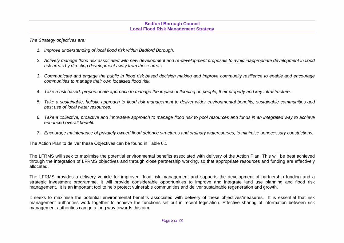
The Strategy objectives are:
1. Improve understanding of local flood risk within Bedford Borough.
2. Actively manage flood risk associated with new development and re-development proposals to avoid inappropriate development in flood risk areas by directing development away from these areas.
3. Communicate and engage the public in flood risk based decision making and improve community resilience to enable and encourage communities to manage their own localised flood risk.
4. Take a risk based, proportionate approach to manage the impact of flooding on people, their property and key infrastructure.
5. Take a sustainable, holistic approach to flood risk management to deliver wider environmental benefits, sustainable communities and best use of local water resources.
6. Take a collective, proactive and innovative approach to manage flood risk to pool resources and funds in an integrated way to achieve enhanced overall benefit.
7. Encourage maintenance of privately owned flood defence structures and ordinary watercourses, to minimise unnecessary constrictions.
The Action Plan to deliver these Objectives can be found in Table 6.1
The LFRMS will seek to maximise the potential environmental benefits associated with delivery of the Action Plan. This will be best achieved through the integration of LFRMS objectives and through close partnership working, so that appropriate resources and funding are effectively allocated. The LFRMS provides a delivery vehicle for improved flood risk management and supports the development of partnership funding and a strategic investment programme. It will provide considerable opportunities to improve and integrate land use planning and flood risk management. It is an important tool to help protect vulnerable communities and deliver sustainable regeneration and growth. It seeks to maximise the potential environmental benefits associated with delivery of these objectives/measures. It is essential that risk management authorities work together to achieve the functions set out in recent legislation. Effective sharing of information between risk management authorities can go a long way towards this aim.
Bedford Borough Council
Local Flood Risk Management Strategy
Page 9 of 73
2. INTRODUCTION
2.1 Background
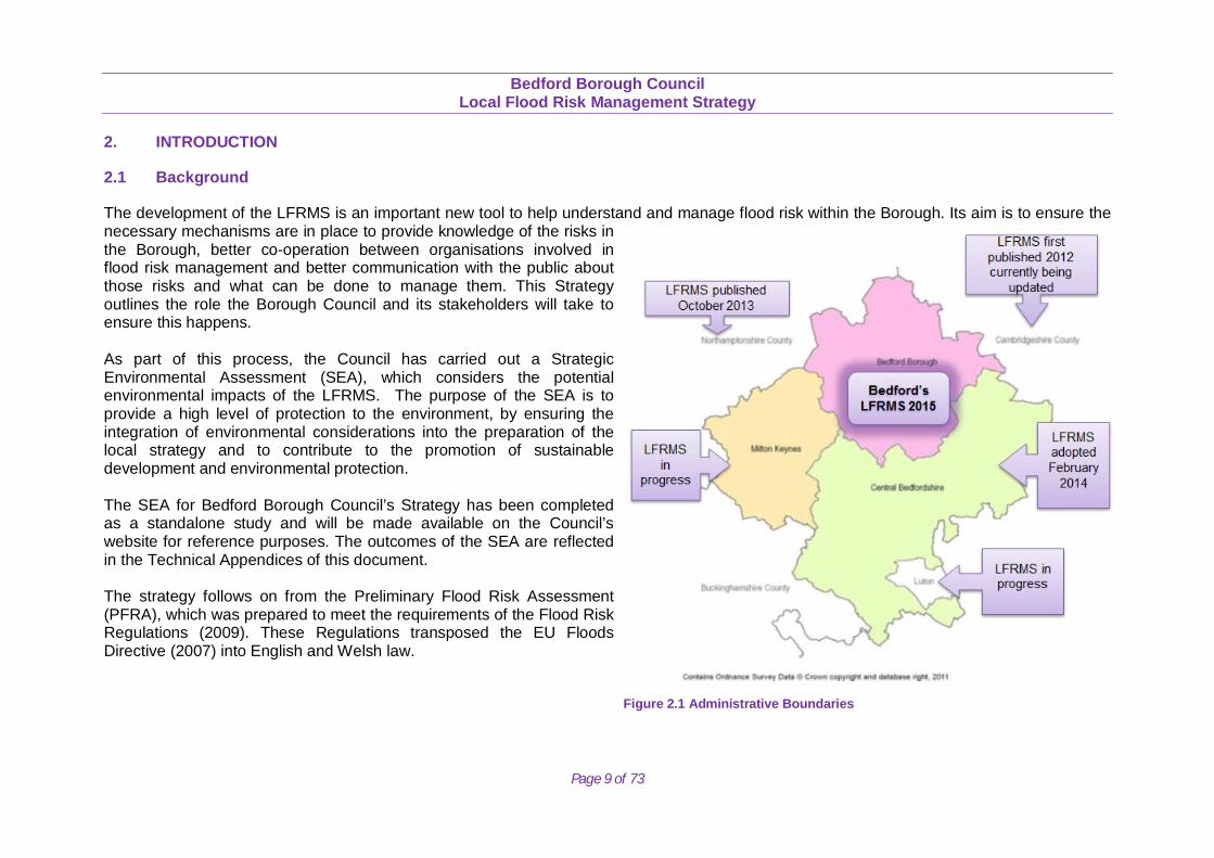
The development of the LFRMS is an important new tool to help understand and manage flood risk within the Borough. Its aim is to ensure the necessary mechanisms are in place to provide knowledge of the risks in the Borough, better co-operation between organisations involved in flood risk management and better communication with the public about those risks and what can be done to manage them. This Strategy outlines the role the Borough Council and its stakeholders will take to ensure this happens. As part of this process, the Council has carried out a Strategic Environmental Assessment (SEA), which considers the potential environmental impacts of the LFRMS. The purpose of the SEA is to provide a high level of protection to the environment, by ensuring the integration of environmental considerations into the preparation of the local strategy and to contribute to the promotion of sustainable development and environmental protection. The SEA for Bedford Borough Council’s Strategy has been completed as a standalone study and will be made available on the Council’s website for reference purposes. The outcomes of the SEA are reflected in the Technical Appendices of this document. The strategy follows on from the Preliminary Flood Risk Assessment (PFRA), which was prepared to meet the requirements of the Flood Risk Regulations (2009). These Regulations transposed the EU Floods Directive (2007) into English and Welsh law. Figure 2.1 Administrative Boundaries
Bedford Borough Council
Local Flood Risk Management Strategy
Page 10 of 73
The PFRA is a high level screening exercise to identify areas of significant risk, referred to as Indicative Flood Risk Areas across England. Areas of significant risk were defined to be locations where 30,000 people or more are at risk from flooding and if present had to be reported to Defra in accordance with the requirements of the Floods Directive. The PFRA established that there are no significant indicative flood risk areas within Bedford Borough. Bedford Borough Council is a Lead Local Flood Authority and is therefore responsible for the management of ‘Local Flood Risk’. Local Flood Risk is defined as surface water flooding, ordinary watercourse flooding (outside the Internal drainage district district) and groundwater flooding, defined by the Flood and Water Management Act 2010. Therefore this LFRMS addresses Local Flood Risk and the interactions it might have with other forms of flood risk. More households are at risk from this form of flooding than any other, but until now there has been little co-ordinated work to address these forms of risk; this strategy will look to address this. The LFRMS covers the Bedford Borough area only. Our neighbouring authorities are also Lead Local Flood Authorities in their own right and as such have the same responsibilities for producing their own Local Flood Risk Management Strategies see figure 2.1. Although this Strategy focuses on managing local sources of flooding, details are also provided about other flood sources and the organisations who lead on managing flood risk from these. The Strategy explains the powers and responsibilities of all the major organisations involved in flood risk management and will provide advice on what householders and businesses can do to protect themselves from flooding. It also highlights and summarises the information available on flooding in Bedford Borough so that this information is more easily accessible for those trying to understand more about flood risk in Bedford Borough.
Bedford Borough Council
Local Flood Risk Management Strategy
Page 11 of 73
2.2 Purpose of the Strategy
The Bedford Borough LRFMS is an important new tool to help individuals, communities, businesses and authorities understand and manage flood risk within the Borough. Its primary focus is on local flooding from surface water, groundwater or ordinary water courses such as streams and ditches.
Bedford Borough Council is now responsible for managing this type of flooding. Local flooding is becoming increasingly common and increasingly important, but until recently there has been little understanding of the risks or actions to address the risk.
Historically, flood risk management has concentrated on high impact and often low frequency river and tidal flooding. In addition, there has been a lot of confusion over who to contact about flooding, particularly surface water flooding.
The aim of the Bedford Borough LFRMS is to produce a plan to reduce and manage flood risk in a way that will benefit people, property and the environment.
2.3 Why has the strategy been produced?
Bedford Borough Council has a statutory duty to produce a strategy. However, the Council and its partners also view the strategy as a real opportunity to work together to reduce risk to residents and businesses and prepare for the future. Traditional approaches to flood risk management need to be supplemented by the community working together and by those at risk taking responsibility to help themselves, alongside the threat from flooding being reduced through robust planning policies, good land management practices, and regular maintenance of water bodies and water management structures.
The risk of flooding cannot be eliminated completely or flood damage be entirely prevented. Where investment may be required it is important it is invested in the highest risk areas as effectively as possible. This Strategy is therefore based on a Borough wide assessment of risk using the most recent and most detailed data and evidence available.
2.4 Who is the strategy aimed at?
The strategy is a source of information for all of those individuals, communities and businesses prone to flood risk. It is also of relevance to authorities with flood risk management responsibilities and other partners, to ensure that there is a common understanding of roles and responsibilities and priorities within Bedford Borough.
Bedford Borough Council
Local Flood Risk Management Strategy
Page 12 of 73
2.5 Legislative Content
Sir Michael Pitt undertook a review of the serious flooding that occurred across England in the summer of 2007. Nationally its effects were significant, of particular importance was the high proportion of flooding that came from surface water runoff, rather than rivers. The roles and responsibilities of Bedford Borough Council and our partners in relation to flood risk management are principally defined by two key pieces of legislation:
The Flood and Water Management Act 2010 The Flood Risk Regulations 2009
2.5.1 Flood and Water Management Act 2010 The Flood and Water Management Act brings together the recommendations of the Pitt Review and previous polices to improve the management of water resources and create a more comprehensive and risk based regime for managing flood risk of flooding from all sources it does this by defining ‘Risk Management Authorities’ (RMA) and formalises the flood risk management role and responsibilities of each. Further details regarding responsibilities and functions in relation to flood risk management can be found in section 4. A key implication for county councils and unitary authorities is the introduction of the Lead Local Flood Authority role, which enhances their responsibilities so that they lead the coordination of local flood risk management in their areas. However, partnership arrangements are encouraged to ensure full use of all capabilities and experience locally. The Flood and Water Management Act outlines the responsibility of the lead local flood authority to ‘develop, maintain, apply and monitor’ a strategy for local flood risk management. It notes that the strategy must identify or outline the following:
the risk management authorities in the area. the flood and coastal erosion risk management functions that may be exercised by those authorities in relation to the area. the objectives for managing local flood risk (including any objectives included in the authority's flood risk management plan prepared in
accordance with the Flood Risk Regulations 2009). the measures proposed to achieve those objectives. how and when the measures are expected to be implemented. the costs and benefits of those measures, and how they are to be paid for
Bedford Borough Council
Local Flood Risk Management Strategy
Page 13 of 73
the assessment of local flood risk for the purpose of the strategy how and when the strategy is to be reviewed how the strategy contributes to the achievement of wider environmental objectives.
2.5.2 The Flood Risk Regulations 2009 The Flood Risk Regulations came into force in December 2009. They transpose the EU Floods Directive into UK law. Key provisions in the regulations include:
To require that preliminary flood risk assessments be prepared by the Environment Agency and lead local flood authorities. Those assessments should identify areas of significant flood risk.
To require that flood hazard and risk maps be prepared, to identify areas of significant flood risk. To require that flood risk management plans are prepared.
Bedford’s Preliminary Flood Risk Assessment is available on the Bedford Borough Council’s website. Flood hazard and flood risk maps are available on the Environment Agency website. 2.5.3 The Reservoirs Act 1975 The Reservoirs Act 1975 and the Flood and Water Management Act 2010 apply to large raised reservoirs. When fully implemented, the Flood and Water Management Act 2010 will update the Reservoirs Act 1975; it will reflect a more risk-based approach to reservoir regulation. Smaller reservoirs (that hold less than 25,000 cubic metres of water above natural ground level) are currently subject to safety regulations managed by the Health and Safety Executive and local authorities. The Reservoirs Act 1975 is in the process of being updated by the Flood and Water management Act 2010. The two main changes are:
Reducing the capacity at which a reservoir will be regulated from 25,000m3 to 10,000m3. An undertaker must prepare a reservoir flood plan.
Bedford Borough Council
Local Flood Risk Management Strategy
Page 14 of 73
2.5.4 The National Flood and Coastal Erosion Risk Management Strategy for England (2011) Local strategies must be consistent with the National Flood and Coastal Erosion Risk Management Strategy (hereafter the national strategy). The national strategy sets out a national framework for managing flood risk and coastal erosion. The Borough Council’s strategy needs to be consistent with the following guiding principles outlined in the national strategy:
community focus and partnership working a catchment and coastal “cell” based approach sustainability proportionate, risk-based approaches multiple beneficiaries should be allowed and encouraged to invest in risk management.
2.5.5 The Planning System The National Planning Policy Framework (NPPF) issued in March 2012 outlines the national policy on development and flood risk assessment, immediately replacing national policy including Planning Policy Statement 25 – Development and Flood Risk. The NPPF requires Local Plans to be supported by a Strategic Flood Risk Assessment and develop policies to manage flood risk from all sources. Advice should be sought from the Environment Agency and other relevant flood risk management bodies, such as Lead Local Flood Authorities (LLFAs) and Internal Drainage Boards (IDBs). In developing policies, Local Plans should apply a sequential, risk-based approach to the location of development in order to avoid flood risk to people and property, to manage any residual risk, and to take account of the impacts of climate change. In addition to this in April 2015 Sustainable urban Drainage Systems (SuDS) proposals are now required on all planning applications which are major developments, as the LLFA, Bedford Borough Council also became a statutory consultee on the drainage element of planning applications to ensure they conform to the necessary national and local SuDS standards. 2.5.6 The EU Water Framework Directive (2000/60/EC) This directive seeks to improve the management, protection and enhancement of the water environment. See section six for details of this is being implemented within the Borough.
Bedford Borough Council
Local Flood Risk Management Strategy
Page 15 of 73
2.5.7 National Strategy for Flood and Coastal Erosion Risk Management The Flood and Water Management Act 2010 requires the Environment Agency to develop, maintain, apply and monitor a strategy for flood and coastal erosion risk management in England. The National Strategy states that the Government will work with individuals, communities and organisations to reduce the threat of flooding and coastal erosion by:
Understanding the risks of flooding and coastal erosion, working together to put in place long-term plans to manage these risks and making sure that other plans take account of them.
Avoiding inappropriate development in areas of flood and coastal erosion risk and being careful to manage land elsewhere to avoid increasing risks.
Building, maintaining and improving flood and coastal erosion management infrastructure and systems to reduce the likelihood of harm
to people and damage to the economy, environment and society.
Increasing public awareness of the risk that remains and engaging with people at risk to make their property more resilient.
Improving the detection, forecasting and issue of warnings of flooding, planning for and co-ordinating a rapid response to flood emergencies and promoting faster recovery from flooding.
The Flood and Water Management Act states that Local Strategies must be consistent with the National Strategy.
2.5.8 Other Legislation Flood Risk Management is affected by a range of other legislation and guidance, these include:
The Climate Change Act (2008) The Conservation of Habitats and Species Regulations (2010) The Civil Contingencies Act (2004) The Strategic Environmental Assessment (SEA) Directive (2001) The Land Drainage Act (1991)
Bedford Borough Council
Local Flood Risk Management Strategy
Page 16 of 73
The Water Industries Act (1991) Wildlife and Countryside Act (1981) Countryside and Rights of Way Act
(2000) Public Health Act (1936) Highways Act (1980)
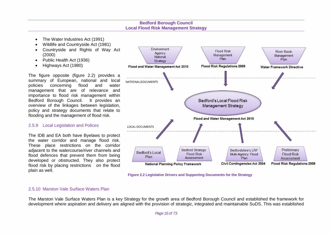
The figure opposite (figure 2.2) provides a summary of European, national and local policies concerning flood and water management that are of relevance and importance to flood risk management within Bedford Borough Council. It provides an overview of the linkages between legislation, policy and strategy documents that relate to flooding and the management of flood risk. 2.5.9 Local Legislation and Polices The IDB and EA both have Byelaws to protect the water corridor and manage flood risk. These place restrictions on the corridor adjacent to the watercourse/river channels and flood defences that prevent them from being developed or obstructed. They also protect flood risk by placing restrictions on the flood plain as well.
Figure 2.2 Legislative Drivers and Supporting Documents for the Strategy
2.5.10 Marston Vale Surface Waters Plan The Marston Vale Surface Waters Plan is a key Strategy for the growth area of Bedford Borough Council and established the framework for development where aspiration and delivery are aligned with the provision of strategic, integrated and maintainable SuDS. This was established
Bedford Borough Council
Local Flood Risk Management Strategy
Page 17 of 73
by the Marston Vale Surface Waters Group, which was established in 1997 and Bedford Borough Council is a key partner. It has been instrumental in delivering significant development such as Wixams, Marsh Leys Land, West of Kempston, Wootton and Cardington. The Surface Waters Plan was part of 15 pilot studies being carried out by Defra to examine a range of different approaches to develop a more integrated urban drainage approach. The Surface Waters Plan for Marston Vale relates directly to flood risk and supports local planning policies. The Surface Waters Plan seeks to encourage landholders, developers and planners to work with the drainage authorities and the Community Forest team to devise strategic lasting solutions, generating a diverse array of benefits including increased amenity and conservation value for the management of flood risk and surface water drainage in Marston Vale.
Bedford Borough Council
Local Flood Risk Management Strategy
Page 18 of 73
3. FLOOD RISK IN BEDFORD BOROUGH
3.1 Characteristics of the Area
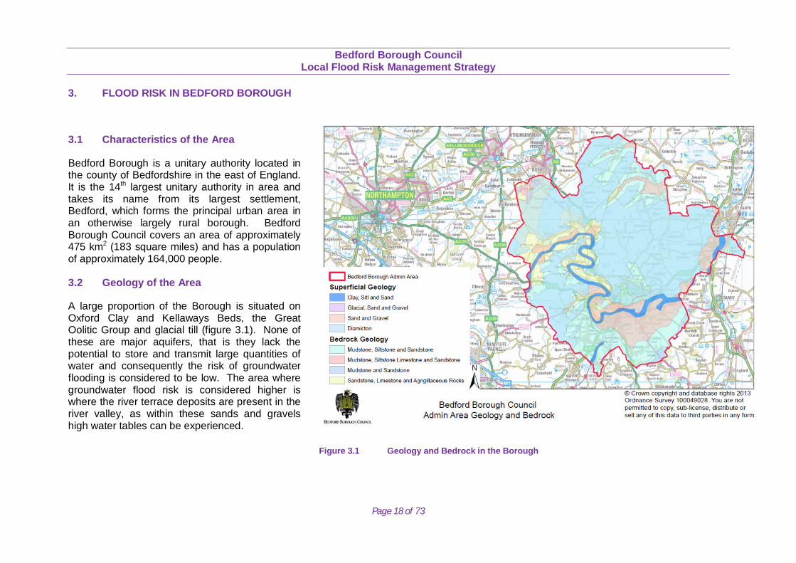
Bedford Borough is a unitary authority located in the county of Bedfordshire in the east of England. It is the 14th largest unitary authority in area and takes its name from its largest settlement, Bedford, which forms the principal urban area in an otherwise largely rural borough. Bedford Borough Council covers an area of approximately 475 km2 (183 square miles) and has a population of approximately 164,000 people. 3.2 Geology of the Area
A large proportion of the Borough is situated on Oxford Clay and Kellaways Beds, the Great Oolitic Group and glacial till (figure 3.1). None of these are major aquifers, that is they lack the potential to store and transmit large quantities of water and consequently the risk of groundwater flooding is considered to be low. The area where groundwater flood risk is considered higher is where the river terrace deposits are present in the river valley, as within these sands and gravels high water tables can be experienced.
Figure 3.1 Geology and Bedrock in the Borough
Bedford Borough Council
Local Flood Risk Management Strategy
Page 19 of 73
3.3 Flooding Characteristics
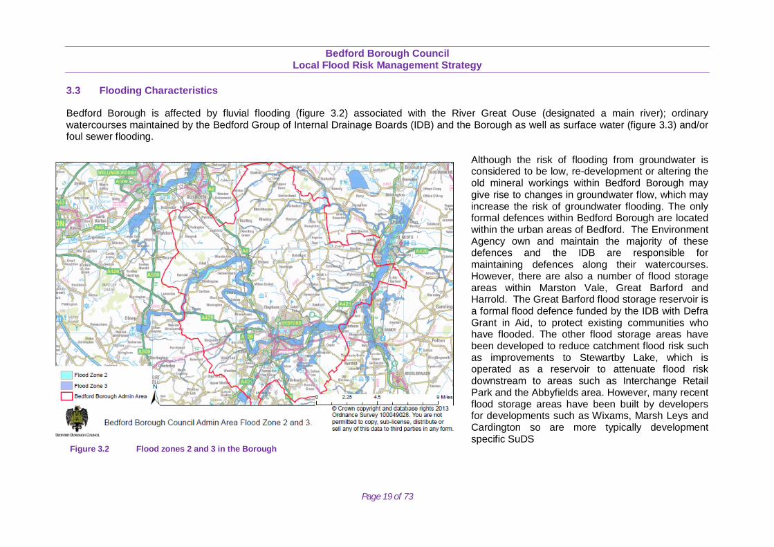
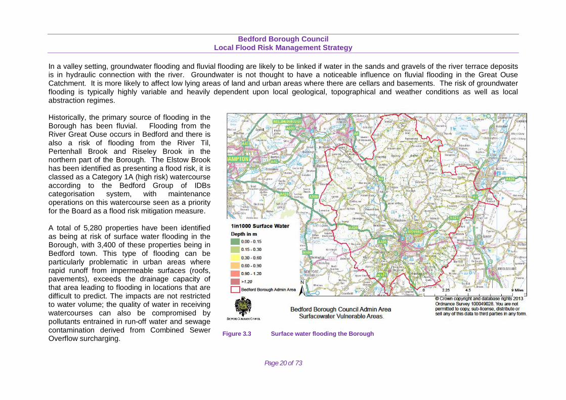
Bedford Borough is affected by fluvial flooding (figure 3.2) associated with the River Great Ouse (designated a main river); ordinary watercourses maintained by the Bedford Group of Internal Drainage Boards (IDB) and the Borough as well as surface water (figure 3.3) and/or foul sewer flooding.
Although the risk of flooding from groundwater is considered to be low, re-development or altering the old mineral workings within Bedford Borough may give rise to changes in groundwater flow, which may increase the risk of groundwater flooding. The only formal defences within Bedford Borough are located within the urban areas of Bedford. The Environment Agency own and maintain the majority of these defences and the IDB are responsible for maintaining defences along their watercourses. However, there are also a number of flood storage areas within Marston Vale, Great Barford and Harrold. The Great Barford flood storage reservoir is a formal flood defence funded by the IDB with Defra Grant in Aid, to protect existing communities who have flooded. The other flood storage areas have been developed to reduce catchment flood risk such as improvements to Stewartby Lake, which is operated as a reservoir to attenuate flood risk downstream to areas such as Interchange Retail Park and the Abbyfields area. However, many recent flood storage areas have been built by developers for developments such as Wixams, Marsh Leys and Cardington so are more typically development specific SuDS
Figure 3.2 Flood zones 2 and 3 in the Borough
Bedford Borough Council
Local Flood Risk Management Strategy
Page 20 of 73
In a valley setting, groundwater flooding and fluvial flooding are likely to be linked if water in the sands and gravels of the river terrace deposits is in hydraulic connection with the river. Groundwater is not thought to have a noticeable influence on fluvial flooding in the Great Ouse Catchment. It is more likely to affect low lying areas of land and urban areas where there are cellars and basements. The risk of groundwater flooding is typically highly variable and heavily dependent upon local geological, topographical and weather conditions as well as local abstraction regimes. Historically, the primary source of flooding in the Borough has been fluvial. Flooding from the River Great Ouse occurs in Bedford and there is also a risk of flooding from the River Til, Pertenhall Brook and Riseley Brook in the northern part of the Borough. The Elstow Brook has been identified as presenting a flood risk, it is classed as a Category 1A (high risk) watercourse according to the Bedford Group of IDBs categorisation system, with maintenance operations on this watercourse seen as a priority for the Board as a flood risk mitigation measure. A total of 5,280 properties have been identified as being at risk of surface water flooding in the Borough, with 3,400 of these properties being in Bedford town. This type of flooding can be particularly problematic in urban areas where rapid runoff from impermeable surfaces (roofs, pavements), exceeds the drainage capacity of that area leading to flooding in locations that are difficult to predict. The impacts are not restricted to water volume; the quality of water in receiving watercourses can also be compromised by pollutants entrained in run-off water and sewage contamination derived from Combined Sewer Overflow surcharging.
Figure 3.3 Surface water flooding the Borough
Bedford Borough Council
Local Flood Risk Management Strategy
Page 21 of 73
3.4 Risks of different Assets The Elstow and Harrowden Brooks come under the IDB’s jurisdiction and are classed as high risk/consequence flood risk assets and are maintained annually. The Great Ouse through Bedford is Main River under the EA’s jurisdiction and is classed as a high risk/consequence system. Many of the watercourses on the flat plain of Wilstead and Cotton End are IDB watercourses defined as medium risk/consequence. The Main River Gt Ouse downstream of the A421 at Goldington is classed as low risk/consequence, similar to minor rural watercourses under the IDB’s jurisdiction such as at Roxton and Mowsbury Hill. 3.5 Areas at Risk Flooding in Bedford Borough can occur for a variety of reasons due to the characteristics of the Borough including a large main river/large river network, heavy clay soils impeding infiltration and contributing to overland flow and a high groundwater level in saturated conditions. As most floods are often caused by the interaction of different sources of flooding it is important that we consider all types of flooding and work with those organisations responsible for their management.
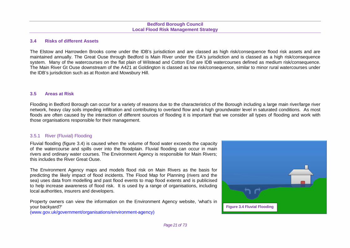
3.5.1 River (Fluvial) Flooding
Fluvial flooding (figure 3.4) is caused when the volume of flood water exceeds the capacity of the watercourse and spills over into the floodplain. Fluvial flooding can occur in main rivers and ordinary water courses. The Environment Agency is responsible for Main Rivers; this includes the River Great Ouse. The Environment Agency maps and models flood risk on Main Rivers as the basis for predicting the likely impact of flood incidents. The Flood Map for Planning (rivers and the sea) uses data from modelling and past flood events to map flood extents and is publicised to help increase awareness of flood risk. It is used by a range of organisations, including local authorities, insurers and developers. Property owners can view the information on the Environment Agency website, 'what's in your backyard?' (www.gov.uk/government/organisations/environment-agency)
Figure 3.4 Fluvial Flooding
Bedford Borough Council
Local Flood Risk Management Strategy
Page 22 of 73
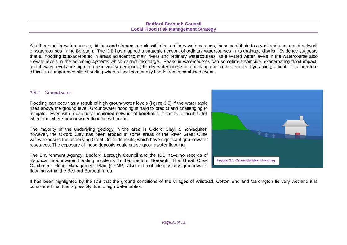
All other smaller watercourses, ditches and streams are classified as ordinary watercourses, these contribute to a vast and unmapped network of watercourses in the Borough. The IDB has mapped a strategic network of ordinary watercourses in its drainage district. Evidence suggests that all flooding is exacerbated in areas adjacent to main rivers and ordinary watercourses, as elevated water levels in the watercourse also elevate levels in the adjoining systems which cannot discharge. Peaks in watercourses can sometimes coincide, exacerbating flood impact, and if water levels are high in a receiving watercourse, feeder watercourse can back up due to the reduced hydraulic gradient. It is therefore difficult to compartmentalise flooding when a local community floods from a combined event. 3.5.2 Groundwater Flooding can occur as a result of high groundwater levels (figure 3.5) if the water table rises above the ground level. Groundwater flooding is hard to predict and challenging to mitigate. Even with a carefully monitored network of boreholes, it can be difficult to tell when and where groundwater flooding will occur. The majority of the underlying geology in the area is Oxford Clay, a non-aquifer, however, the Oxford Clay has been eroded in some areas of the River Great Ouse valley exposing the underlying Great Oolite deposits, which have significant groundwater resources. The exposure of these deposits could cause groundwater flooding. The Environment Agency, Bedford Borough Council and the IDB have no records of historical groundwater flooding incidents in the Bedford Borough. The Great Ouse Catchment Flood Management Plan (CFMP) also did not identify any groundwater flooding within the Bedford Borough area. It has been highlighted by the IDB that the ground conditions of the villages of Wilstead, Cotton End and Cardington lie very wet and it is considered that this is possibly due to high water tables.
Figure 3.5 Groundwater Flooding
Bedford Borough Council
Local Flood Risk Management Strategy
Page 23 of 73
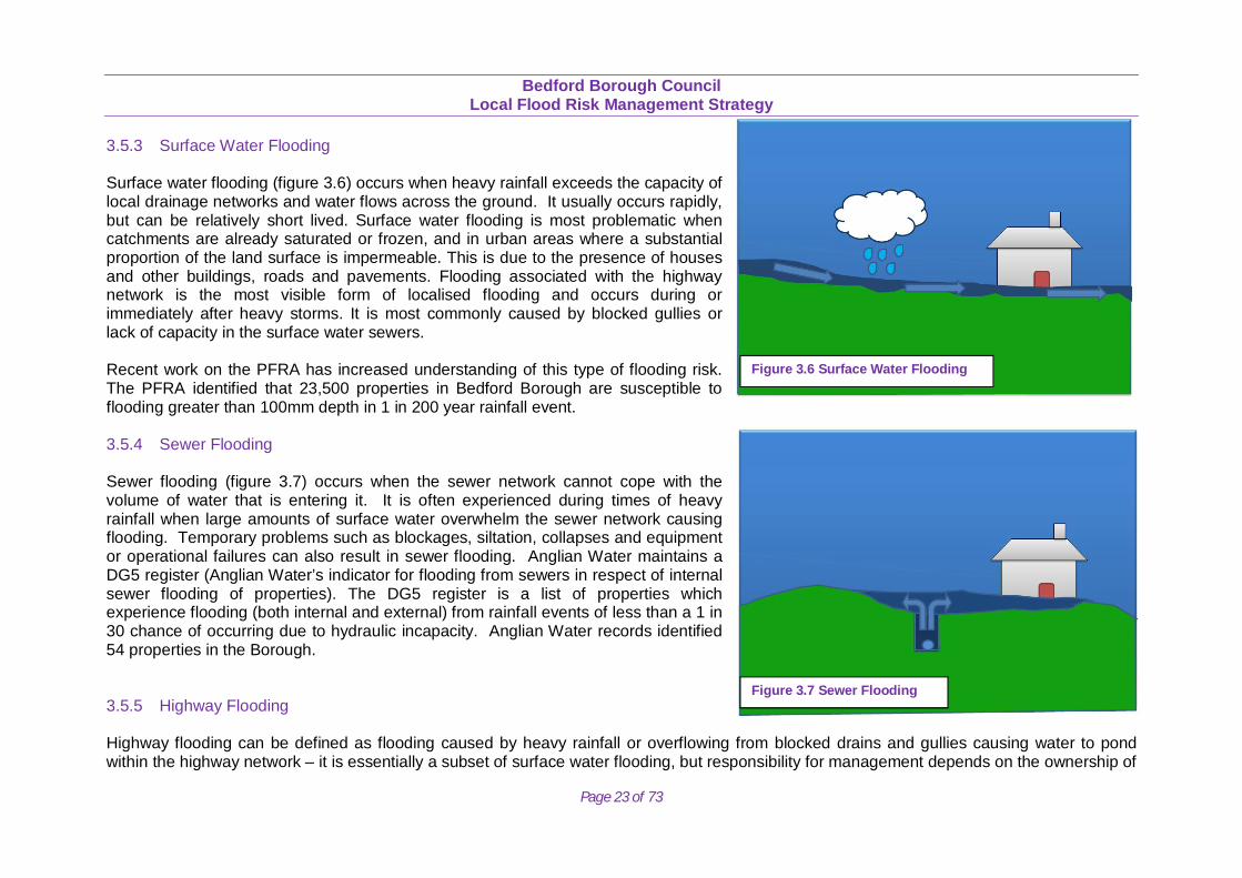
3.5.3 Surface Water Flooding Surface water flooding (figure 3.6) occurs when heavy rainfall exceeds the capacity of local drainage networks and water flows across the ground. It usually occurs rapidly, but can be relatively short lived. Surface water flooding is most problematic when catchments are already saturated or frozen, and in urban areas where a substantial proportion of the land surface is impermeable. This is due to the presence of houses and other buildings, roads and pavements. Flooding associated with the highway network is the most visible form of localised flooding and occurs during or immediately after heavy storms. It is most commonly caused by blocked gullies or lack of capacity in the surface water sewers. Recent work on the PFRA has increased understanding of this type of flooding risk. The PFRA identified that 23,500 properties in Bedford Borough are susceptible to flooding greater than 100mm depth in 1 in 200 year rainfall event. 3.5.4 Sewer Flooding Sewer flooding (figure 3.7) occurs when the sewer network cannot cope with the volume of water that is entering it. It is often experienced during times of heavy rainfall when large amounts of surface water overwhelm the sewer network causing flooding. Temporary problems such as blockages, siltation, collapses and equipment or operational failures can also result in sewer flooding. Anglian Water maintains a DG5 register (Anglian Water’s indicator for flooding from sewers in respect of internal sewer flooding of properties). The DG5 register is a list of properties which experience flooding (both internal and external) from rainfall events of less than a 1 in 30 chance of occurring due to hydraulic incapacity. Anglian Water records identified 54 properties in the Borough. 3.5.5 Highway Flooding Highway flooding can be defined as flooding caused by heavy rainfall or overflowing from blocked drains and gullies causing water to pond within the highway network – it is essentially a subset of surface water flooding, but responsibility for management depends on the ownership of
Figure 3.7 Sewer Flooding
Figure 3.6 Surface Water Flooding

Bedford Borough Council
Local Flood Risk Management Strategy
Page 24 of 73
the highway being flooded. During the PFRA process, highway flooding reports were collected from around 150 different locations and this data is included in the overall evidence base of flood information. 3.5.6 Interaction with Main Rivers The primary source of flood risk in Bedford Borough is fluvial flooding. The River Great Ouse passes through the centre of Bedford and through many of the surrounding villages. In addition to the River Great Ouse there is a risk from the River Til and the Riseley and Pertenhall Brooks to the north of Bedford. The Elstow Brook to the south of Bedford poses a flood risk. There are also numerous smaller watercourses and ditches that cross the Borough. Figure 3.1 shows the location and flood risk (from Environment Agency Flood Zones) of these watercourses. 3.5.7 Communities and Flood Risk
Figure 3.8 highlights the Borough’s historic flood events where there have been previous flooding incidents and where the Council is actively involved in managing flood risk. This focus on individual area allows resources to be effectively targeted and measures effectively. With the smaller communities the Council alongside the Environment Agency are actively trying to set up community flood groups to work with the local communities to enable them to help themselves. This approach has seen huge benefits particularly to communities such as Riseley and Odell where the flood groups that have been set up are actively managing local flood risk as well as keeping the Council and Environment Agency updated with local knowledge and issues.
Figure 3.8 Historic flooding in the Borough
Bedford Borough Council
Local Flood Risk Management Strategy
Page 25 of 73
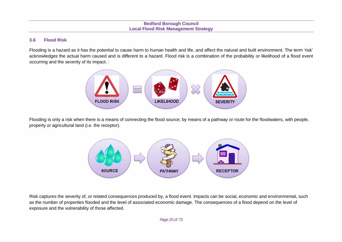
3.6 Flood Risk
Flooding is a hazard as it has the potential to cause harm to human health and life, and affect the natural and built environment. The term ‘risk’ acknowledges the actual harm caused and is different to a hazard. Flood risk is a combination of the probability or likelihood of a flood event occurring and the severity of its impact. :
Flooding is only a risk when there is a means of connecting the flood source, by means of a pathway or route for the floodwaters, with people, property or agricultural land (i.e. the receptor).
Risk captures the severity of, or related consequences produced by, a flood event. Impacts can be social, economic and environmental, such as the number of properties flooded and the level of associated economic damage. The consequences of a flood depend on the level of exposure and the vulnerability of those affected.
Bedford Borough Council
Local Flood Risk Management Strategy
Page 26 of 73
3.7 Historical Flooding
Through completion of the PFRA historic flood records were collated across the Borough. Additional records were provided by the EA, IDB, AWS and other consultees. These have been identified in Figure 3.7. These flood records came from a range of sources, and in many cases the source of flooding was unknown or not recorded, possibly due to the nature of the interaction and inter-dependencies of our local system of main rivers, ordinary watercourses, public and private sewers, and highway drainage. In addition there are the complexities of flooding caused by asset failures, exceedance, obstruction from blockages and capacity issues, which may have subsequently been alleviated with maintenance, emergency measures or capital works. Bedford’s Strategic Flood Risk Assessment, also contains extensive information regarding historic flooding, including the 1947, 1980, 1983, 1987, 1992, 1998 and 2003 events. It reports that there are 23,500 properties at risk of surface water flooding. Below is a summary of the historic flooding incidents that have occurred across the Borough:
1980 In August 1980 Bromham Brook flooded 62 homes and caravans.
1983
On the 1st May 1983 the Bromham Brook overtopped its banks and flooded seven properties; six on Brook Way, one at Wick End. A peak flow was estimated at 24m3/s based upon water marks, and a peak flow of 18m3/s was estimated using the Flood Studies Report (FSR) method. The preceding rainfall event was found to have a return period of 10% AEP.
1987
In October 1987 moderately high rainfall fell over the catchment with 20-40mm in 24 hours. This rainfall combined with a Soil Moisture Deficit (SMD) which had reached zero, flooded a number of areas; the road between Kimbolton to Stonely became impassable for 24 hours.
1992
In 1992 the Bedford Ouse catchment was subjected to intense rainfall, between 40-80mm in 24 hours, with SMD values marginally above zero. Flood waters affected the Riseley Brook with 18 properties in Riseley affected. Two industrial developments in Riseley were also flooded.
Bedford Borough Council
Local Flood Risk Management Strategy
Page 27 of 73
In Bedford, one property was flooded. The B660 at Kimbolton had a depth of water of 250mm; on the A45 water depths reached 450mm. A public house in Turvey (a known flood risk area) flooded during this event. Properties were also flooded in Kimbolton, Great Staughton and Bedford. Sharnbrook Road was also inundated by flood waters.
1998
In Easter 1998, the River Great Ouse in Bedford overtopped its banks on Saturday 11th April. Many homes in the North of Bedfordshire and Bedford were flooded and more than 500 homes in Bedford had their electricity supply cut off as electricity supplies were impacted.
2003
In 2003 the IDB instigated a closure of the A1 (southbound) at Sandy due to flooding, however this was in the Mid Bedfordshire district and there was no reports of flooding within Bedford Borough.
2012
In May and July 2012 the basement of one property in Sharnbrook was flooded with sewage and surface water. In July 2012 a care home was flooded with surface water in Bedford and the ground floor of one property flooded in Great Barford to a depth of 500mm. In November 2012 one property was flooded in Keysoe Row West due to Surface water runoff / groundwater. In December 2012 one property flooded in Upper Dean from the nearby watercourse and a commercial property in Oakley flooded from groundwater.
2013
In Carlton the school was flooded in one room and the basement.
2015 In May 2015 a school flooded from a burst water main in Queens Park.
Bedford Borough Council
Local Flood Risk Management Strategy
Page 28 of 73
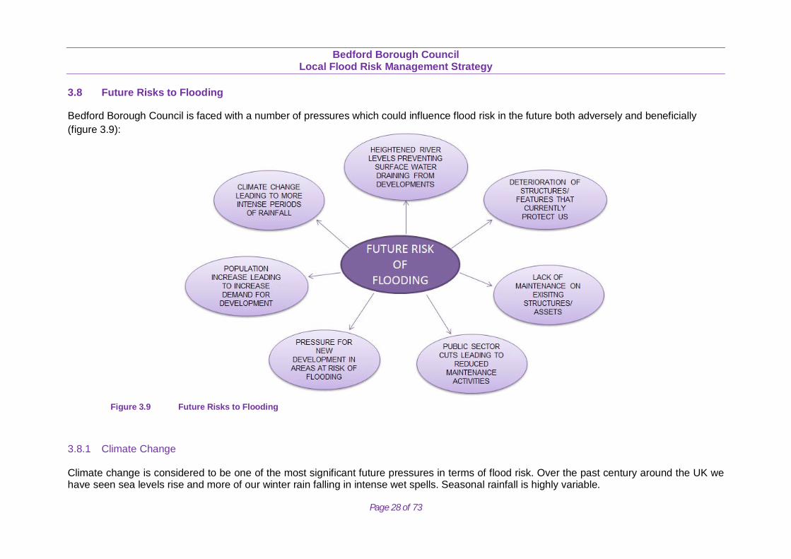
3.8 Future Risks to Flooding
Bedford Borough Council is faced with a number of pressures which could influence flood risk in the future both adversely and beneficially (figure 3.9):
3.8.1 Climate Change Climate change is considered to be one of the most significant future pressures in terms of flood risk. Over the past century around the UK we have seen sea levels rise and more of our winter rain falling in intense wet spells. Seasonal rainfall is highly variable.
Figure 3.9 Future Risks to Flooding
Bedford Borough Council
Local Flood Risk Management Strategy
Page 29 of 73
It seems to have decreased in summer and increased in winter, although winter amounts changed little in the last 50 years. Some of the changes might reflect natural variation; however the broad trends are in line with projections from climate models. Greenhouse gas (GHG) levels in the atmosphere are likely to cause higher winter rainfall in future. Past GHG emissions mean some climate change is inevitable in the next 20-30 years. Lower emissions could reduce the amount of climate change further into the future, but changes are still projected at least as far ahead as the 2080s. We have enough confidence in large scale climate models to say that we must plan for change. There is more uncertainty at a local scale but model results can still help us plan to adapt. For example we understand rain storms may become more intense, even if we cannot be sure about exactly where or when. By the 2080s, the latest UK Climate Projections (UKCP09) are that there could be around three times as many days in winter with heavy rainfall (defined as more than 25mm in a day). It is plausible that the amount of rain in extreme storms (with a 1 in 5 annual chance or rarer) could increase locally by 40%.
3.8.2 Key Projections for Anglian River Basin District If emissions follow a medium future scenario, UKCP09 projected changes by the 2050s relative to the recent past are:
• Winter precipitation increases of around 14% (very likely to be between 3 and 31%). • Precipitation on the wettest day in winter up by around 14% (very unlikely to be more than 29%). • Peak river flows in a typical catchment likely to increase between 8 and 16%.
3.8.3 Implications for Flood Risk Climate changes can affect local flood risk in several ways. Impacts will depend on local conditions and vulnerability. Wetter winters and more of this rain falling in wet spells may increase river flooding. More intense rainfall causes more surface water runoff, increasing localised flooding and erosion. In turn, this may increase pressure on drains, sewers and water quality. Storm intensity in summer could increase even in drier summers, so we need to be prepared for the unexpected. Drainage systems in the Borough have been modified to manage water levels and could help in adapting locally to some impacts of future climate change on flooding, but may also need to be managed differently. Rising sea or river levels may also increase local flood risk inland or away from major rivers because of interactions with drains, sewers and smaller watercourses. Where appropriate, we need local studies to understand climate impacts in detail, including effects from other factors like land use. A map showing the modelled climate change impact for a 1 in 100 year flood event can be found in the Technical Appendices T.2.
Bedford Borough Council
Local Flood Risk Management Strategy
Page 30 of 73
Sustainable development and drainage will help us adapt to climate change and manage the risk of damaging floods in future. 3.8.4 Adapting to Change Past emission means some climate change is inevitable. It is essential we respond by planning ahead. We can prepare by understanding our current and future vulnerability to flooding, developing plans for increased resilience and building the capacity to adapt. Regular review and adherence to these plans is key to achieving long-term, sustainable benefits. Although the broad climate change picture is clear, we have to make local decisions. We will therefore consider a range of measures and retain flexibility to adapt. This approach, embodied within flood risk appraisal guidance, will help to ensure that we do not increase our vulnerability to flooding. In addition to this is the Council’s commitment to ensuring SuDS are delivered through the planning process, ensuring all major developments manage rainwater and surface water that replicates natural drainage, the key objective being to manage flow rate and volume of runoff to reduce risk of flooding. 3.8.5 Long Term Developments It is possible that long term developments might affect the occurrence and significance of flooding. However current planning policy aims to prevent new development from increasing flood risk. The National Planning Policy Framework (NPPF) regulates the assessment of flood risks and their appropriate mitigations through the planning process. The NPPF sets out strict tests to protect people and property from flooding which all local planning authorities are expected to follow. Where these tests are not met, national policy is clear that new development should not be allowed. The tests are designed to ensure that if there are better sites in terms of flood risk or a proposed development cannot be made safe, it should not be permitted. Without effective planning policy, there is a risk that the increase in impermeable surfaces associated with new developments will increase surface water runoff and, consequently, the risk of flooding. It is therefore vital that flood risk to, and caused by, a new development is fully assessed as part of the consideration of any planning applications. It is also important that the impact of climate change is considered when planning new developments to ensure they are sited in areas which will not increase flood risk to the development or surrounding areas in the future. In England, the National Planning Policy Framework and supporting technical guidance will ensure that “inappropriate development in areas at risk of flooding should be avoided by directing development away from areas at highest risk, but where development is necessary, making it safe without increasing flooding risk elsewhere”. Bedford’s Borough Council is currently preparing the Local Plan that will set out how much growth there should be in the Borough and where is should take place up to 2032. The Local Plan uses evidence from the Strategic Flood Risk Assessment to inform where development is best placed. This goes towards reducing flood risk from new and existing developments, whilst allowing for climate change across the Borough. Sustainable development and drainage, including the use of Sustainable Drainage Systems (SuDS), will also help to adapt to climate change and manage the risk of damaging flooding in the future.
Bedford Borough Council
Local Flood Risk Management Strategy
Page 31 of 73
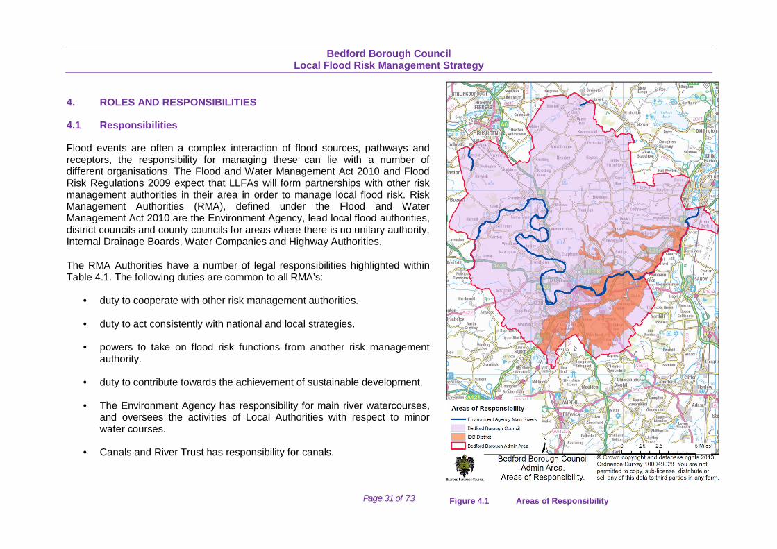
4. ROLES AND RESPONSIBILITIES
4.1 Responsibilities
Flood events are often a complex interaction of flood sources, pathways and receptors, the responsibility for managing these can lie with a number of different organisations. The Flood and Water Management Act 2010 and Flood Risk Regulations 2009 expect that LLFAs will form partnerships with other risk management authorities in their area in order to manage local flood risk. Risk Management Authorities (RMA), defined under the Flood and Water Management Act 2010 are the Environment Agency, lead local flood authorities, district councils and county councils for areas where there is no unitary authority, Internal Drainage Boards, Water Companies and Highway Authorities. The RMA Authorities have a number of legal responsibilities highlighted within Table 4.1. The following duties are common to all RMA’s:
• duty to cooperate with other risk management authorities. • duty to act consistently with national and local strategies.
• powers to take on flood risk functions from another risk management
authority.
• duty to contribute towards the achievement of sustainable development.
• The Environment Agency has responsibility for main river watercourses, and oversees the activities of Local Authorities with respect to minor water courses.
• Canals and River Trust has responsibility for canals.
Figure 4.1 Areas of Responsibility
Bedford Borough Council
Local Flood Risk Management Strategy
Page 32 of 73
• Local authorities have a mixture of responsibilities. Unitary and County Councils are highway drainage authorities, whilst Unitary and District Councils are planning authorities with responsibility for ensuring satisfactory drainage for developments and for compliance with building standards.
• Main roads are managed by the Highways Agency and other roads by Local Authorities. The Highways Agency receives most of its
funding from central government. The local highways authority is part of the Local Authority and is funded through the Revenue Support Grant (RSG) from Central Government and localised Council Tax.
• Internal Drainage Boards (IDBs) manage all water courses in an IDB area, which is usually an area of high flood risk.
• Riparian owners are required to maintain the free flow of water (see section 4.9 for definition of Riparian Owner).
Bedford Borough Council
Local Flood Risk Management Strategy
Page 33 of 73
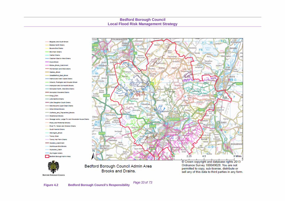
Figure 4.2 Bedford Borough Council’s Responsibility
Bedford Borough Council
Local Flood Risk Management Strategy
Page 34 of 73
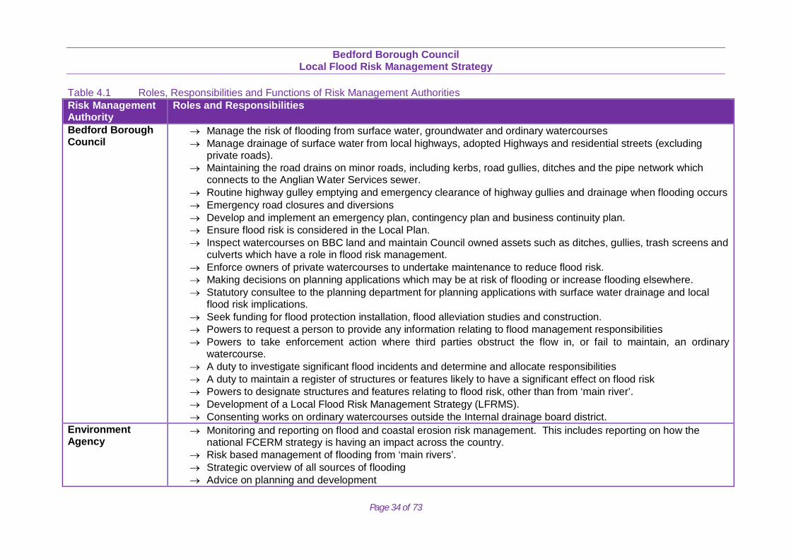
Table 4.1 Roles, Responsibilities and Functions of Risk Management Authorities Risk Management Authority
Roles and Responsibilities
Bedford Borough Council
Manage the risk of flooding from surface water, groundwater and ordinary watercourses Manage drainage of surface water from local highways, adopted Highways and residential streets (excluding
private roads). Maintaining the road drains on minor roads, including kerbs, road gullies, ditches and the pipe network which
connects to the Anglian Water Services sewer. Routine highway gulley emptying and emergency clearance of highway gullies and drainage when flooding occurs Emergency road closures and diversions Develop and implement an emergency plan, contingency plan and business continuity plan. Ensure flood risk is considered in the Local Plan. Inspect watercourses on BBC land and maintain Council owned assets such as ditches, gullies, trash screens and
culverts which have a role in flood risk management. Enforce owners of private watercourses to undertake maintenance to reduce flood risk. Making decisions on planning applications which may be at risk of flooding or increase flooding elsewhere. Statutory consultee to the planning department for planning applications with surface water drainage and local
flood risk implications. Seek funding for flood protection installation, flood alleviation studies and construction. Powers to request a person to provide any information relating to flood management responsibilities Powers to take enforcement action where third parties obstruct the flow in, or fail to maintain, an ordinary
watercourse. A duty to investigate significant flood incidents and determine and allocate responsibilities A duty to maintain a register of structures or features likely to have a significant effect on flood risk Powers to designate structures and features relating to flood risk, other than from ‘main river’. Development of a Local Flood Risk Management Strategy (LFRMS). Consenting works on ordinary watercourses outside the Internal drainage board district.
Environment Agency
Monitoring and reporting on flood and coastal erosion risk management. This includes reporting on how the national FCERM strategy is having an impact across the country.
Risk based management of flooding from ‘main rivers’. Strategic overview of all sources of flooding Advice on planning and development
Bedford Borough Council
Local Flood Risk Management Strategy
Page 35 of 73
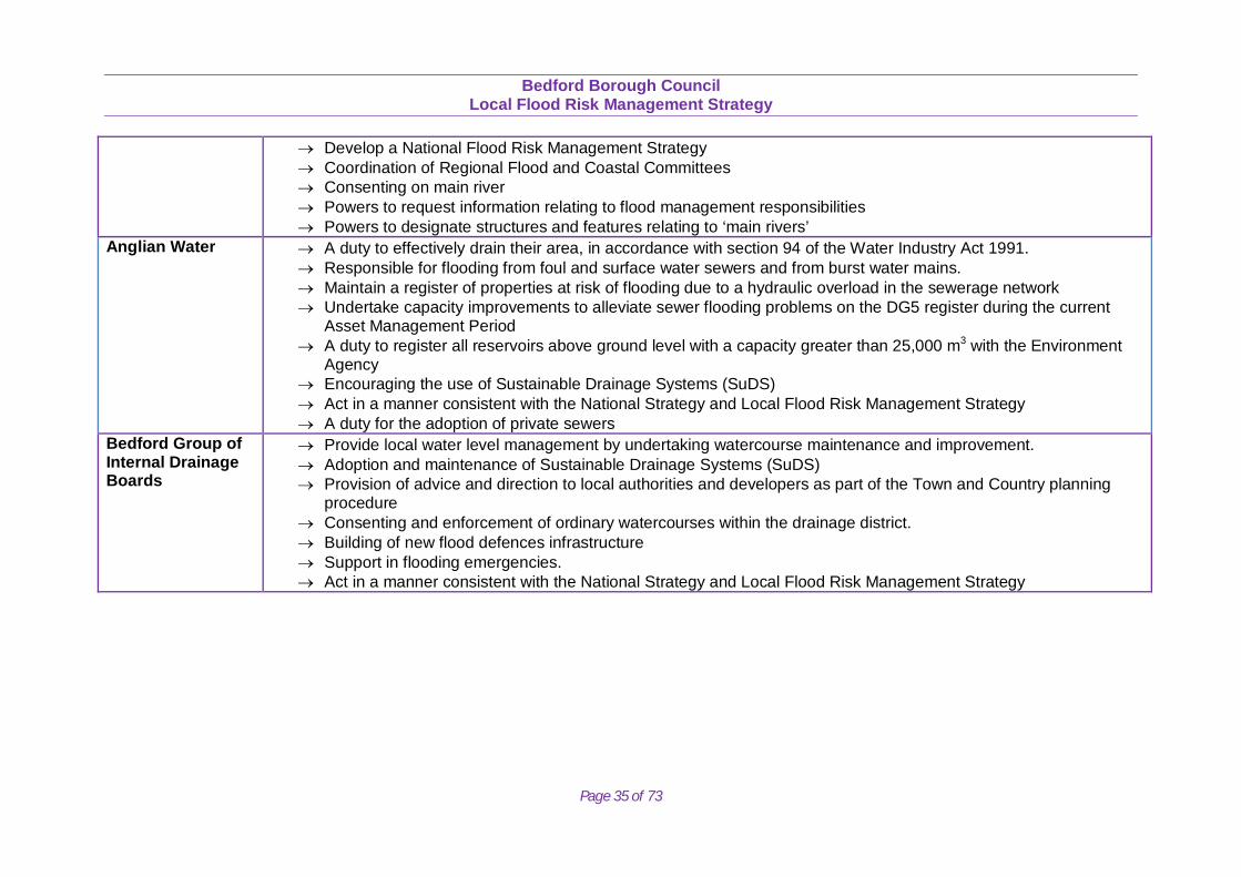
Develop a National Flood Risk Management Strategy Coordination of Regional Flood and Coastal Committees Consenting on main river Powers to request information relating to flood management responsibilities Powers to designate structures and features relating to ‘main rivers’
Anglian Water A duty to effectively drain their area, in accordance with section 94 of the Water Industry Act 1991. Responsible for flooding from foul and surface water sewers and from burst water mains. Maintain a register of properties at risk of flooding due to a hydraulic overload in the sewerage network Undertake capacity improvements to alleviate sewer flooding problems on the DG5 register during the current
Asset Management Period A duty to register all reservoirs above ground level with a capacity greater than 25,000 m3 with the Environment
Agency Encouraging the use of Sustainable Drainage Systems (SuDS) Act in a manner consistent with the National Strategy and Local Flood Risk Management Strategy A duty for the adoption of private sewers
Bedford Group of Internal Drainage Boards
Provide local water level management by undertaking watercourse maintenance and improvement. Adoption and maintenance of Sustainable Drainage Systems (SuDS) Provision of advice and direction to local authorities and developers as part of the Town and Country planning
procedure Consenting and enforcement of ordinary watercourses within the drainage district. Building of new flood defences infrastructure Support in flooding emergencies. Act in a manner consistent with the National Strategy and Local Flood Risk Management Strategy
Bedford Borough Council
Local Flood Risk Management Strategy
Page 36 of 73
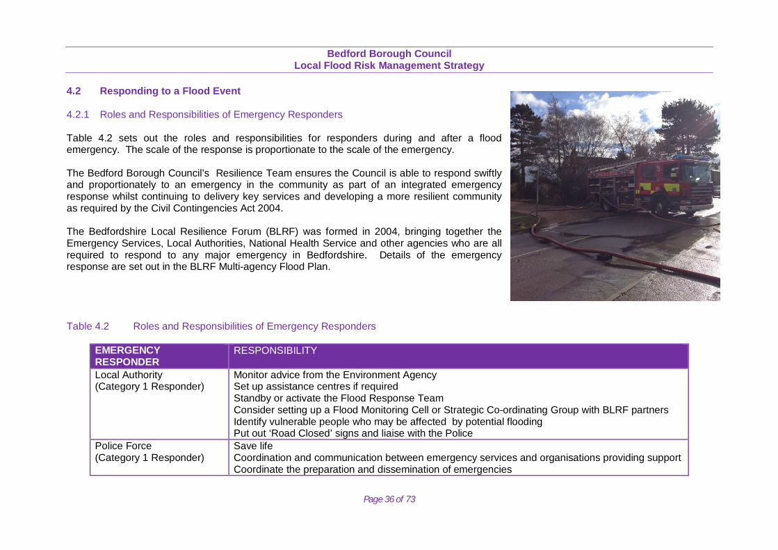
4.2 Responding to a Flood Event 4.2.1 Roles and Responsibilities of Emergency Responders Table 4.2 sets out the roles and responsibilities for responders during and after a flood emergency. The scale of the response is proportionate to the scale of the emergency. The Bedford Borough Council’s Resilience Team ensures the Council is able to respond swiftly and proportionately to an emergency in the community as part of an integrated emergency response whilst continuing to delivery key services and developing a more resilient community as required by the Civil Contingencies Act 2004. The Bedfordshire Local Resilience Forum (BLRF) was formed in 2004, bringing together the Emergency Services, Local Authorities, National Health Service and other agencies who are all required to respond to any major emergency in Bedfordshire. Details of the emergency response are set out in the BLRF Multi-agency Flood Plan.
Table 4.2 Roles and Responsibilities of Emergency Responders
EMERGENCY RESPONDER
RESPONSIBILITY
Local Authority (Category 1 Responder)
Monitor advice from the Environment Agency Set up assistance centres if required Standby or activate the Flood Response Team Consider setting up a Flood Monitoring Cell or Strategic Co-ordinating Group with BLRF partners Identify vulnerable people who may be affected by potential flooding Put out ‘Road Closed’ signs and liaise with the Police
Police Force (Category 1 Responder)
Save life Coordination and communication between emergency services and organisations providing support Coordinate the preparation and dissemination of emergencies
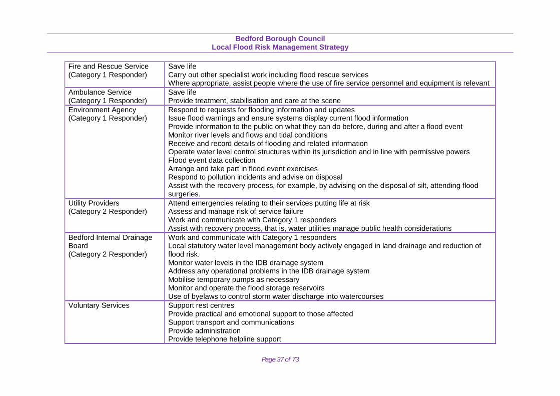
Bedford Borough Council
Local Flood Risk Management Strategy
Page 37 of 73
Fire and Rescue Service (Category 1 Responder)
Save life Carry out other specialist work including flood rescue services Where appropriate, assist people where the use of fire service personnel and equipment is relevant
Ambulance Service (Category 1 Responder)
Save life Provide treatment, stabilisation and care at the scene
Environment Agency (Category 1 Responder)
Respond to requests for flooding information and updates Issue flood warnings and ensure systems display current flood information Provide information to the public on what they can do before, during and after a flood event Monitor river levels and flows and tidal conditions Receive and record details of flooding and related information Operate water level control structures within its jurisdiction and in line with permissive powers Flood event data collection Arrange and take part in flood event exercises Respond to pollution incidents and advise on disposal Assist with the recovery process, for example, by advising on the disposal of silt, attending flood surgeries.
Utility Providers (Category 2 Responder)
Attend emergencies relating to their services putting life at risk Assess and manage risk of service failure Work and communicate with Category 1 responders Assist with recovery process, that is, water utilities manage public health considerations
Bedford Internal Drainage Board (Category 2 Responder)
Work and communicate with Category 1 responders Local statutory water level management body actively engaged in land drainage and reduction of flood risk. Monitor water levels in the IDB drainage system Address any operational problems in the IDB drainage system Mobilise temporary pumps as necessary Monitor and operate the flood storage reservoirs Use of byelaws to control storm water discharge into watercourses
Voluntary Services Support rest centres Provide practical and emotional support to those affected Support transport and communications Provide administration Provide telephone helpline support
Bedford Borough Council
Local Flood Risk Management Strategy
Page 38 of 73
4.3 Bedford Borough Council’s Role as a Lead Local Flood Authority (LLFA)
Bedford Borough Council has a number of duties and discretionary powers as the LLFA. Including:
SuDS Statutory Consultee
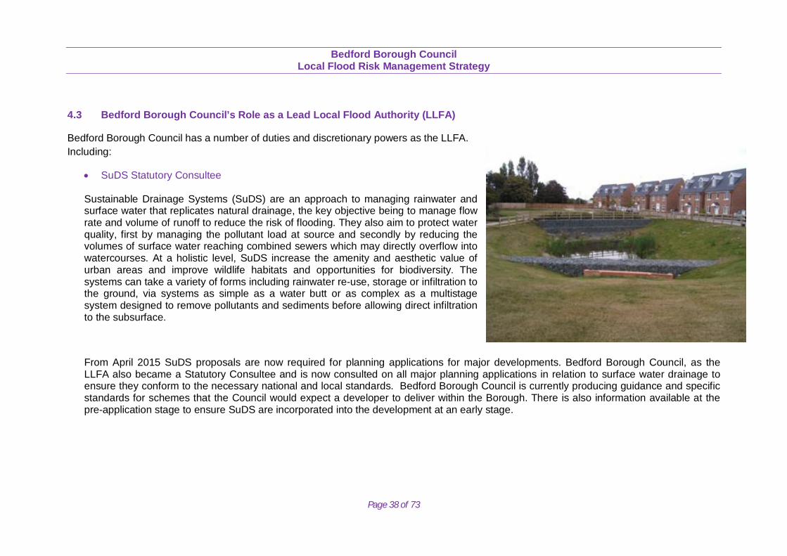
Sustainable Drainage Systems (SuDS) are an approach to managing rainwater and surface water that replicates natural drainage, the key objective being to manage flow rate and volume of runoff to reduce the risk of flooding. They also aim to protect water quality, first by managing the pollutant load at source and secondly by reducing the volumes of surface water reaching combined sewers which may directly overflow into watercourses. At a holistic level, SuDS increase the amenity and aesthetic value of urban areas and improve wildlife habitats and opportunities for biodiversity. The systems can take a variety of forms including rainwater re-use, storage or infiltration to the ground, via systems as simple as a water butt or as complex as a multistage system designed to remove pollutants and sediments before allowing direct infiltration to the subsurface.
From April 2015 SuDS proposals are now required for planning applications for major developments. Bedford Borough Council, as the LLFA also became a Statutory Consultee and is now consulted on all major planning applications in relation to surface water drainage to ensure they conform to the necessary national and local standards. Bedford Borough Council is currently producing guidance and specific standards for schemes that the Council would expect a developer to deliver within the Borough. There is also information available at the pre-application stage to ensure SuDS are incorporated into the development at an early stage.
Bedford Borough Council
Local Flood Risk Management Strategy
Page 39 of 73
Duty to Investigate and Report on Flood Incidents
On becoming aware of a flood in its area, the LLFA must undertake an investigation to the extent that it considers necessary or appropriate. This investigation must set out which risk management authority is responsible and whether they have responded appropriately to the flood. The results of the investigation must be published. In Bedford an initial investigation will be carried out in any circumstance of internal property flooding or of key infrastructure flooding. A number of criteria will then determine whether a full investigation is undertaken and which risk management authority leads on producing it. The results of a formal flood investigation will be published on the Bedford Borough Council website.
4.4 Bedford Borough Council’s Role as the Regulator of Ordinary Watercourses
Under the Land Drainage Act 1991, the Council has permissive powers to consent and designate structures on Ordinary Watercourses (figure 4.2).
Power to Designate Structures
The power to designate structures that have an effect on flood risk commenced in 2012. Bedford Borough Council and the Environment Agency are now able to designate natural or artificial features that are important for flood or coastal erosion risk management. A feature can be designated if:
• The existence or location of the feature affects flood risk. • The designating authority has responsibility for the risk that is affected. • The feature has not been designated already (including by another authority). • Is not owned by another designating authority.
Designation means that a feature may not be altered, replaced or removed without consent. Designated features will be added to the asset register.
Bedford Borough Council
Local Flood Risk Management Strategy
Page 40 of 73
Powers to Consent
The Borough Council is responsible for the consenting of works to ordinary watercourses and has powers to enforce unconsented and non-compliant works. This includes any works, including temporary, that affect flow within the channel of any ordinary watercourse, such as in-channel structures or diversion of watercourses. Consent is refused if the works would result in an increase in flood risk, a prevention of operational access to the watercourse and/ or they pose an unacceptable risk to nature conservation. Bedford Borough Council has an internal consenting process that it will follow to ensure consistency.
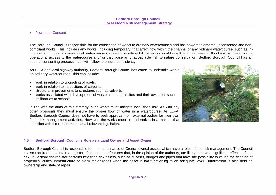
As LLFA and local highway authority, Bedford Borough Council has cause to undertake works on ordinary watercourses. This can include:
• work in relation to upgrading of roads. • work in relation to inspections of culverts. • structural improvements to structures such as culverts. • works associated with development of waste and mineral sites and their own sites such
as libraries or schools.
In line with the aims of this strategy, such works must mitigate local flood risk. As with any other proposals they must ensure the proper flow of water in a watercourse. As LLFA, Bedford Borough Council does not have to seek approval from external bodies for their own flood risk management activities. However, the works must be undertaken in a manner that complies with the requirements of all relevant legislation.
4.5 Bedford Borough Council’s Role as a Land Owner and Asset Owner Bedford Borough Council is responsible for the maintenance of Council owned assets which have a role in flood risk management. The Council is also required to maintain a register of structures or features that, in the opinion of the authority, are likely to have a significant effect on flood risk. In Bedford the register contains key flood risk assets, such as culverts, bridges and pipes that have the possibility to cause the flooding of properties, critical infrastructure or block major roads when the asset is not functioning to an adequate level. Information is also held on ownership and state of repair.
Bedford Borough Council
Local Flood Risk Management Strategy
Page 41 of 73
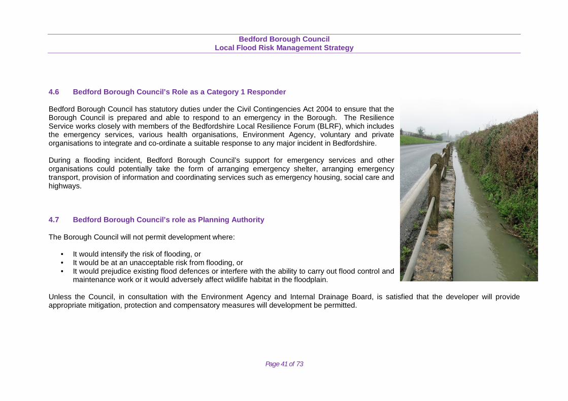
4.6 Bedford Borough Council’s Role as a Category 1 Responder Bedford Borough Council has statutory duties under the Civil Contingencies Act 2004 to ensure that the Borough Council is prepared and able to respond to an emergency in the Borough. The Resilience Service works closely with members of the Bedfordshire Local Resilience Forum (BLRF), which includes the emergency services, various health organisations, Environment Agency, voluntary and private organisations to integrate and co-ordinate a suitable response to any major incident in Bedfordshire. During a flooding incident, Bedford Borough Council’s support for emergency services and other organisations could potentially take the form of arranging emergency shelter, arranging emergency transport, provision of information and coordinating services such as emergency housing, social care and highways. 4.7 Bedford Borough Council’s role as Planning Authority The Borough Council will not permit development where:
• It would intensify the risk of flooding, or • It would be at an unacceptable risk from flooding, or • It would prejudice existing flood defences or interfere with the ability to carry out flood control and
maintenance work or it would adversely affect wildlife habitat in the floodplain. Unless the Council, in consultation with the Environment Agency and Internal Drainage Board, is satisfied that the developer will provide appropriate mitigation, protection and compensatory measures will development be permitted.
Bedford Borough Council
Local Flood Risk Management Strategy
Page 42 of 73
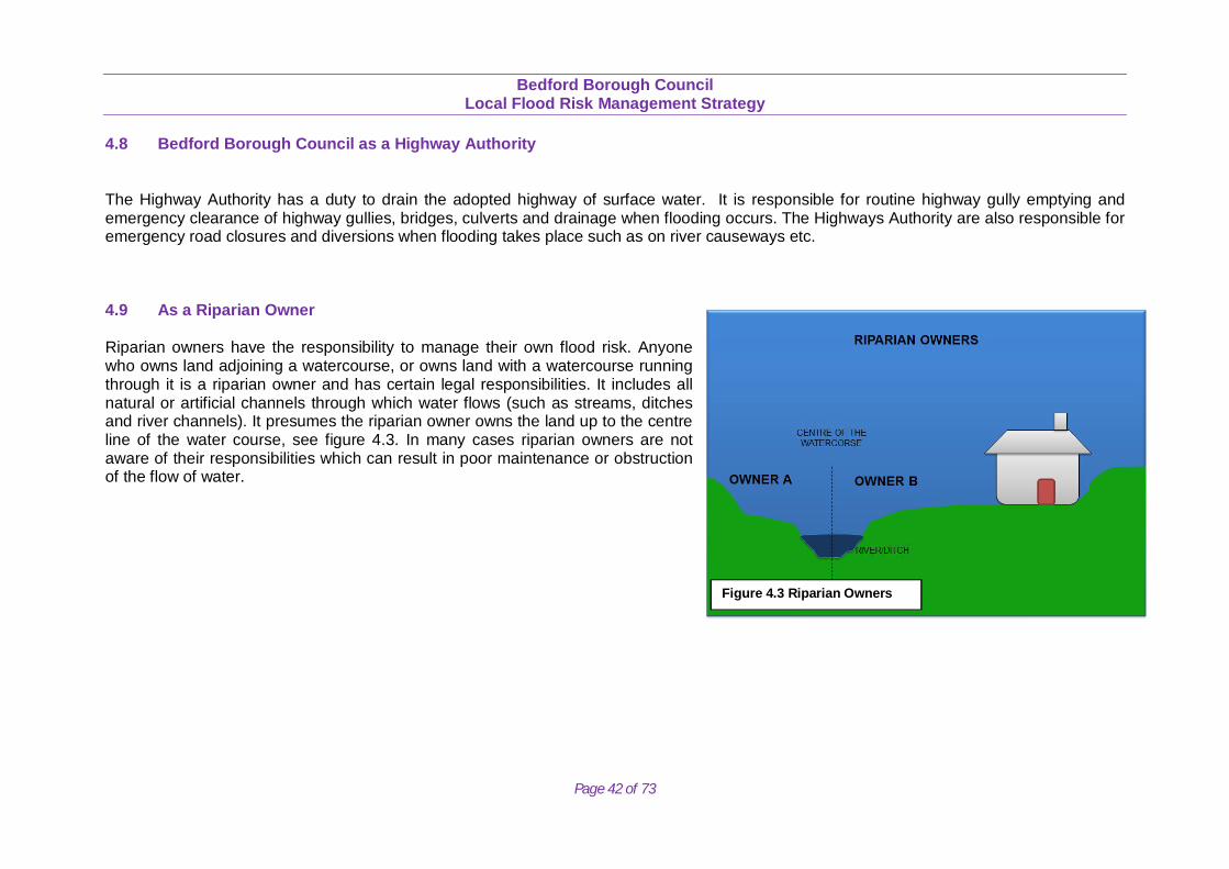
4.8 Bedford Borough Council as a Highway Authority The Highway Authority has a duty to drain the adopted highway of surface water. It is responsible for routine highway gully emptying and emergency clearance of highway gullies, bridges, culverts and drainage when flooding occurs. The Highways Authority are also responsible for emergency road closures and diversions when flooding takes place such as on river causeways etc. 4.9 As a Riparian Owner Riparian owners have the responsibility to manage their own flood risk. Anyone who owns land adjoining a watercourse, or owns land with a watercourse running through it is a riparian owner and has certain legal responsibilities. It includes all natural or artificial channels through which water flows (such as streams, ditches and river channels). It presumes the riparian owner owns the land up to the centre line of the water course, see figure 4.3. In many cases riparian owners are not aware of their responsibilities which can result in poor maintenance or obstruction of the flow of water.
Figure 4.3 Riparian Owners
Bedford Borough Council
Local Flood Risk Management Strategy
Page 43 of 73
5. PARTNERSHIPS AND GOVERNANCE
5.1 Working in Partnership
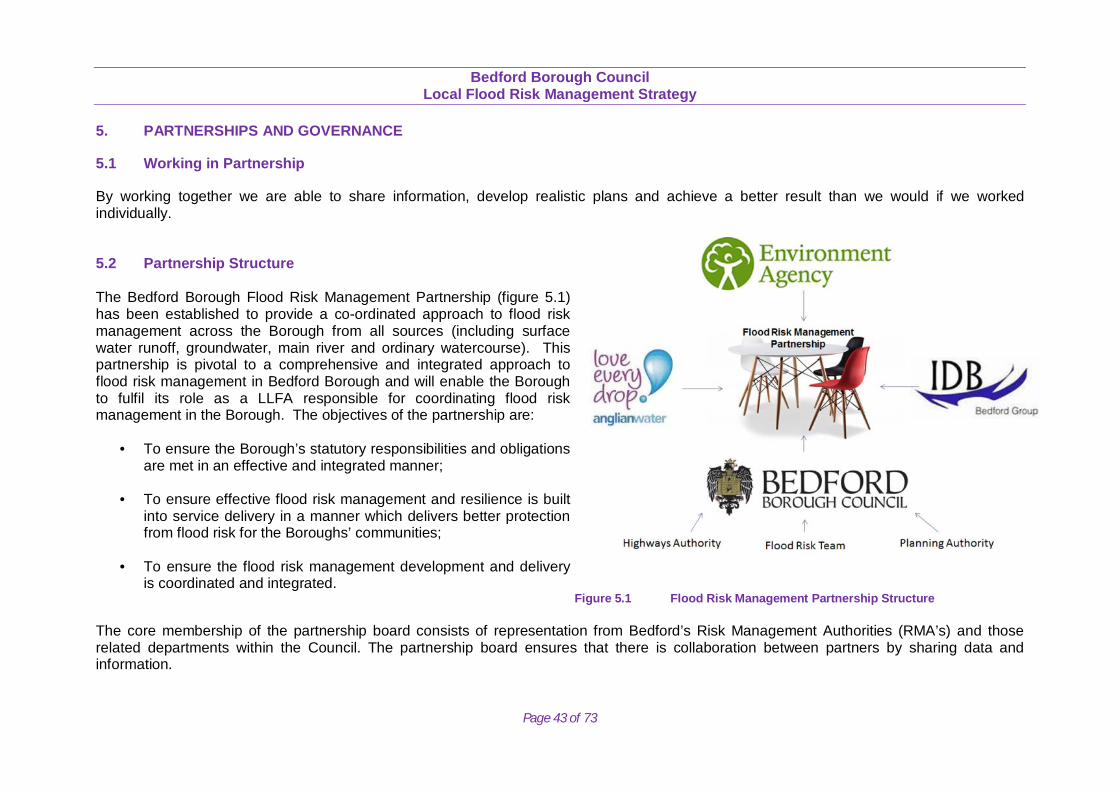
By working together we are able to share information, develop realistic plans and achieve a better result than we would if we worked individually. 5.2 Partnership Structure The Bedford Borough Flood Risk Management Partnership (figure 5.1) has been established to provide a co-ordinated approach to flood risk management across the Borough from all sources (including surface water runoff, groundwater, main river and ordinary watercourse). This partnership is pivotal to a comprehensive and integrated approach to flood risk management in Bedford Borough and will enable the Borough to fulfil its role as a LLFA responsible for coordinating flood risk management in the Borough. The objectives of the partnership are:
• To ensure the Borough’s statutory responsibilities and obligations are met in an effective and integrated manner;
• To ensure effective flood risk management and resilience is built into service delivery in a manner which delivers better protection from flood risk for the Boroughs’ communities;
• To ensure the flood risk management development and delivery
is coordinated and integrated. Figure 5.1 Flood Risk Management Partnership Structure
The core membership of the partnership board consists of representation from Bedford’s Risk Management Authorities (RMA’s) and those related departments within the Council. The partnership board ensures that there is collaboration between partners by sharing data and information.
Bedford Borough Council
Local Flood Risk Management Strategy
Page 44 of 73
5.3 Strategic Leadership
Bedford Borough Council has developed the Local Flood Risk Steering Group. The steering group was formed to ensure that there is a strategic approach to flood risk management in the Bedford Borough area and includes all departments of the Council that may have an impact or input into flood risk management. The Steering Group feeds back into the Partnership meetings. Following the adoption of this strategy the steering group will meet to discuss how to deliver the actions set out in the strategy. Through the steering group, the Council are working to ensure that there is a joint understanding of local flood risk and that our priorities are joined up. The Environment and Sustainable Communities Overview and Scrutiny Committee (ESOSC) provide scrutiny to Flood and Water Management activities of Bedford Borough Council as necessary. 5.4 Anglian Regional Flood and Coastal Committee The Anglian Central Regional Flood and Coastal Committee (RFCC) cover the jurisdiction of Bedford Borough. The RFCC is a committee established by the Environment Agency under the Flood and Water Management Act that brings together elected members appointed by Lead Local Flood Authorities (LLFAs) and independent members with relevant experience to:
to ensure there are coherent plans for identifying, communicating and managing flood and coastal erosion risks across catchments and shorelines
to promote efficient, targeted and risk-based investment in flood and coastal erosion risk management that optimises value for money and benefits to local communities
to provide a link between the Environment Agency, LLFAs, other risk management authorities and other relevant bodies, to engender mutual understanding of flood and coastal erosion risks in its area
The RFCC also acts as a link between the Environment Agency, LLFA and other Risk Management Authorities and are responsible for promoting efficient and risk based investment in flood risk management and coastal erosion.
5.5 Regional Partnership LLFAs in the Anglian region have established a flooding sub-group (Upper Great River Ouse Partnership) as a means of sharing best practice and understanding on how they are each responding to the new duties created under the Flood and Water Management Act.
Bedford Borough Council
Local Flood Risk Management Strategy
Page 45 of 73
6. OBJECTIVES AND ACTIONS
6.1 Our Vision and Actions
Bedford Borough Council has clear priorities and ambitions for the Borough which are set out in the Council’s Corporate Plan (2012-2016). The Plan sets out these priorities under four key themes. These are:
• Providing a Healthy Future • Protecting and Preserving the Local Environment • Brighter Futures for Children • Serving Residents Effectively
The supporting actions in the Corporate Plan seek to meet the needs of the many communities within the Borough and will contribute to making Bedford a better place to live, work and visit. Our vision for Local Flood Risk is to adopt a pragmatic approach to flood risk management. By working with local communities and RMA’s we can work towards a more sustainable and holistic approach to flood risk management. 6.2 Complementary Plans and Strategies Several plans related to flood risk have previously been developed which provide a strong evidence base and direction for local flood risk management. They include, in chronological order:
Anglian River Basin Management Plan (RBMP) - The delivery mechanism for the Water Framework Directive objectives, produced by the
Environment Agency, the plan focuses on the protection, improvement and sustainable use of the water environment. Anglian Flood Risk Management Plan (FRMP) - Prepared by the Environment Agency to manage the risk of flooding from rivers, the sea,
reservoirs, surface water and groundwater. Bedford Borough Strategic Flood Risk Assessment (SFRA) – Provides a general assessment of flood risk across Bedford Borough
rural area and key service areas. The SFRA is a tool to help direct planned development towards those areas of lowest flood risk.
Bedford Borough Council
Local Flood Risk Management Strategy
Page 46 of 73
Great Ouse Catchment Flood Management Plan (CFMP) – Prepared by the Environment Agency, proposing catchment-wide, long-term
measures, the CFMP considers all types of flooding and sets the context and direction for more local, detailed plans. Preliminary Flood Risk Assessment (PFRA) December 2011 – Required under the Flood Risk Regulations 2009. The Bedford Group of
Internal Drainage Boards prepared the joint Preliminary Flood Risk Assessment (2011) on behalf of Bedford Borough Council, Central Bedfordshire Council and Milton Keynes Council. The assessment quantifies the level of flood risk from all sources across the district, highlighting areas at significant risk.
The National Flood and Coastal Erosion Risk Management Strategy for England 2011 – Sets out the Environment Agency’s overview
role in flood and coastal erosion risk management encouraging more effective partnership working between national and local agencies and communities.
The Marston Vale Surface Waters Plan – Produced on behalf of the Marston Vale Surface Waters Group, a key Strategy for the growth area of Bedford Borough Council and established the framework where development aspiration and delivery are aligned with the provision of strategic, integrated and maintainable SuDS.
6.3 Consistency with National Objectives The LFRMS is required to be consistent with the National Flood and Coastal Erosion Risk Management Strategy and will be consistent with the main policies and measures outlined below. It will include all current policies and measures which have been adopted in current flood management – related plans, which are relevant to the management of local flood risk.
Bedford Borough Council
Local Flood Risk Management Strategy
Page 47 of 73
6.4 Consultation with LFRMS 6.4.1 Summary of 2014 consultation The LFRMS was developed in a staged approach to allow for graduated consultation and engagement with those organisations and members of the public who will be effected. An initial survey was put together in 2014 to gain views from the public. The responses to the questions were then used to inform the prioritisation and delivery of actions within the Action Plan to manage flood risk in the local area and help prioritise areas for future community engagement, awareness raising and community resilience.
A paper and online version of the public survey was created and the public were given the opportunity from March to May 2014 to respond. 173 responses were received to the consultation. The same questions were included in the Citizens Panel Survey which took place in January to March 2014 and 492 responses were received to the survey. The Citizens Panel is a group of people, broadly representative of the Borough population. Panel Members agree to receive surveys on local issues either via post or online, via email. The Panel was established in 1999 and has proved to be an excellent consultation tool, acting as a way of sounding out opinion on a range of issues and ideas.
The percentages stated are calculated from all respondents giving a valid response to that question, and those not giving a response are excluded. Where percentages do not add up to 100, it is due to rounding or when questions allow multiple responses. A summary of the responses can be found below.
The three main considerations respondents would like the LFRMS to address are:
o ‘Maintenance of watercourses’ (80%) o ‘The effect of new development on flooding’ (66%) o ‘Secure funding for defence and improvement works’ (41%).
Most respondents in both surveys stated that their current understanding of flooding in their local area is that ‘It is not at risk of flooding’
(63%). Those that are at risk or have been flooded reported that they have taken the following steps ‘nothing’ (11%), ‘Signed up for flood warnings’ (8%) and ‘Prepared a flood plan’ (4%).
The approach that should be taken to improve services is to ‘Reduce the risk of flooding wherever possible’ (61%). The highest priority
when it comes to protecting against flood risk in the Borough is ‘Homes’ (83%).
Bedford Borough Council
Local Flood Risk Management Strategy
Page 48 of 73
The three main areas that the respondents would like the Council to target with its current resources are: o ‘Maintenance of watercourses’ (71%) o ‘Ensuring new developments are built outside of flood zones’ (55%) o ‘Maintenance of road drainage’ (51%).
Respondents stated that additional sources of funding for flood alleviation schemes can be reasonably sought from the following three
areas ‘Developers’ (84%), ‘Businesses who benefit from the project’ (54%) and ‘Utility companies’ (53%). The survey highlighted that the public’s highest priority is maintenance of watercourses, which is now set out in the measures within the Action Plan. 6.4.2 Summary of the 2015 consultation A second public consultation was completed in 2015, where the public, stakeholders and RMA’s were given the opportunity to comment on the draft LFRMS that had been produced. The development of the Strategy had developed from the initial consultation, with the main aims of the Strategy focussing on maintenance and management in a proactive approach. The consultation took place from the 26 March 2015 until the 21 May 2015, this was an eight week consultation where members of the public, stakeholders and RMA’s had a chance to comment on the draft LFRMS, the Action Plan, the SEA and the opportunity to feedback on how strongly or not they agreed with the seven objectives outlined in section 6.5. The questions to the 2015 consultation were kept open with the intention of eliciting a broad response and to allow specific areas of concern or comments to be brought forward. The aim of this second consultation was to consolidate the development of the Strategy to ensure the document was consistent with both public and RMA’s expectations. A much smaller number of responses were received (seven responses), however the Council did receive comprehensive comments from the EA, RFCC, and IDB. The main comments received indicated that the draft Strategy required further development to ensure that it was consistent with the guiding principles of the National FCERM Strategy, that there should be more focus on a catchment based approach to inform a proportionate, risk based approach, that the document should fully utilise the wider role and partnerships of flood risk management. It was also recognised that the draft Strategy provides a framework whereby all RMA’s are empowered to carryout watercourse maintenance, with appropriate funding streams being secured where necessary. All of the comments received have broadly been integrated into the final development of this Strategy to ensure it is workable and gains support, not only from other RMA’s, but also from the public. The developed Strategy has ensured it focuses on a more proportionate, risk
Bedford Borough Council
Local Flood Risk Management Strategy
Page 49 of 73
based approach, enhancing the past excellent partnership working partnership that has taken place whilst providing a framework for the maintenance of watercourses across the Borough on a partnership basis. 6.5 The Objectives of the Strategy The LFRMS needs to provide a clear vision as to how local flood risk will be managed by the Council and its partners. The objectives in the Strategy include statutory requirements from legislation, complementary objectives stated in relevant plans and strategies and preferences expressed, or known, within local communities. We have also ensured they are consistent with the objectives and guiding principles within the National Flood and Coastal Erosion Risk Management Strategy. The objectives are:
1. Improve understanding of local flood risk within Bedford Borough.
2. Actively manage flood risk associated with new development and re-development proposals to avoid inappropriate development in flood risk areas by directing development away from these areas.
3. Communicate and engage the public in flood risk based decision making and improve community resilience to enable communities to help themselves.
4. Take a risk based, proportionate approach to manage the impact of flooding on people, their property and key infrastructure.
5. Take a sustainable, holistic approach to flood risk management to deliver wider environmental benefits, sustainable communities and best use of local water resources.
6. Take a collective, proactive and innovative approach to manage flood risk to pool resources and funds in an integrated way to achieve enhanced overall benefit.
7. Encourage maintenance of privately owned flood defence structures and ordinary watercourses, and minimise unnecessary constrictions.
Bedford Borough Council
Local Flood Risk Management Strategy
Page 50 of 73
6.6 The Measures Proposed to Achieve the Objectives It would be impractical to carry out all measures to account for all situations which may arise. The Strategy will help to determine which measures are most appropriate for Bedford Borough, which measures offer best value for money and how a blend of measure types (structural and non-structural) can/should be used to mitigate risk. The measures can broadly be categorised into the following themes:
• Studies, assessments and plans • Development planning and adaptation • Flood awareness, response and recovery • Land management • Asset improvement, management and maintenance
The Strategy objectives and actions that the Council and its partners propose to carry out to achieve them are detailed below (6.1).
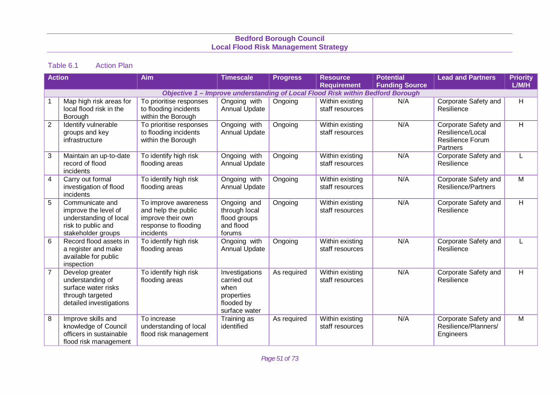
Bedford Borough Council
Local Flood Risk Management Strategy
Page 51 of 73
Table 6.1 Action Plan Action Aim Timescale Progress Resource
Requirement Potential Funding Source
Lead and Partners Priority L/M/H
Objective 1 – Improve understanding of Local Flood Risk within Bedford Borough 1 Map high risk areas for
local flood risk in the Borough
To prioritise responses to flooding incidents within the Borough
Ongoing with Annual Update
Ongoing Within existing staff resources
N/A Corporate Safety and Resilience
H
2 Identify vulnerable groups and key infrastructure
To prioritise responses to flooding incidents within the Borough
Ongoing with Annual Update
Ongoing Within existing staff resources
N/A Corporate Safety and Resilience/Local Resilience Forum Partners
H
3 Maintain an up-to-date record of flood incidents
To identify high risk flooding areas
Ongoing with Annual Update
Ongoing Within existing staff resources
N/A Corporate Safety and Resilience
L
4 Carry out formal investigation of flood incidents
To identify high risk flooding areas
Ongoing with Annual Update
Ongoing Within existing staff resources
N/A Corporate Safety and Resilience/Partners
M
5 Communicate and improve the level of understanding of local risk to public and stakeholder groups
To improve awareness and help the public improve their own response to flooding incidents
Ongoing and through local flood groups and flood forums
Ongoing Within existing staff resources
N/A Corporate Safety and Resilience
H
6 Record flood assets in a register and make available for public inspection
To identify high risk flooding areas
Ongoing with Annual Update
Ongoing Within existing staff resources
N/A Corporate Safety and Resilience
L
7 Develop greater understanding of surface water risks through targeted detailed investigations
To identify high risk flooding areas
Investigations carried out when properties flooded by surface water
As required Within existing staff resources
N/A Corporate Safety and Resilience
H
8 Improve skills and knowledge of Council officers in sustainable flood risk management
To increase understanding of local flood risk management
Training as identified
As required Within existing staff resources
N/A Corporate Safety and Resilience/Planners/Engineers
M
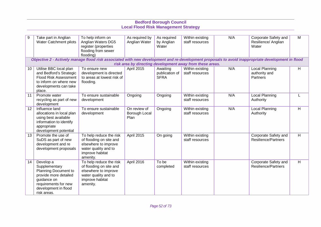
Bedford Borough Council
Local Flood Risk Management Strategy
Page 52 of 73
9 Take part in Anglian Water Catchment pilots
To help inform on Anglian Waters DG5 register (properties flooding from sewer flooding)
As required by Anglian Water
As required by Anglian Water
Within existing staff resources
N/A Corporate Safety and Resilience/ Anglian Water
M
Objective 2 - Actively manage flood risk associated with new development and re-development proposals to avoid inappropriate development in flood risk area by directing development away from these areas.
10 Utilise BBC local plan and Bedford’s Strategic Flood Risk Assessment to inform on where new developments can take place.
To ensure new development is directed to areas at lowest risk of flooding.
April 2015
Awaiting publication of SFRA
Within existing staff resources
N/A Local Planning authority and Partners
H
11 Promote water recycling as part of new development
To ensure sustainable development
Ongoing Ongoing Within existing staff resources
N/A Local Planning Authority
L
12 Influence land allocations in local plan using best available information to identify appropriate development potential
To ensure sustainable development
On review of Borough Local Plan
Ongoing Within existing staff resources
N/A Local Planning Authority
H
13 Promote the use of SuDS as part of new development and re development proposals
To help reduce the risk of flooding on site and elsewhere to improve water quality and to improve habitat amenity.
April 2015 On going Within existing staff resources
Corporate Safety and Resilience/Partners
H
14 Develop a Supplementary Planning Document to provide more detailed guidance on requirements for new development in flood risk areas.
To help reduce the risk of flooding on site and elsewhere to improve water quality and to improve habitat amenity.
April 2016 To be completed
Within existing staff resources
Corporate Safety and Resilience/Partners
H
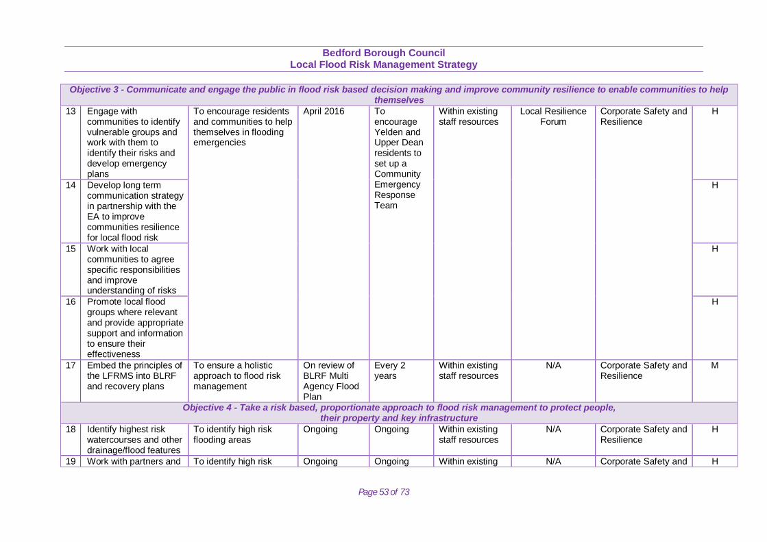
Bedford Borough Council
Local Flood Risk Management Strategy
Page 53 of 73
Objective 3 - Communicate and engage the public in flood risk based decision making and improve community resilience to enable communities to help themselves
13 Engage with communities to identify vulnerable groups and work with them to identify their risks and develop emergency plans
To encourage residents and communities to help themselves in flooding emergencies
April 2016 To encourage Yelden and Upper Dean residents to set up a Community Emergency Response Team
Within existing staff resources
Local Resilience Forum
Corporate Safety and Resilience
H
14 Develop long term communication strategy in partnership with the EA to improve communities resilience for local flood risk
H
15 Work with local communities to agree specific responsibilities and improve understanding of risks
H
16 Promote local flood groups where relevant and provide appropriate support and information to ensure their effectiveness
H
17 Embed the principles of the LFRMS into BLRF and recovery plans
To ensure a holistic approach to flood risk management
On review of BLRF Multi Agency Flood Plan
Every 2 years
Within existing staff resources
N/A Corporate Safety and Resilience
M
Objective 4 - Take a risk based, proportionate approach to flood risk management to protect people, their property and key infrastructure
18 Identify highest risk watercourses and other drainage/flood features
To identify high risk flooding areas
Ongoing Ongoing Within existing staff resources
N/A Corporate Safety and Resilience
H
19 Work with partners and To identify high risk Ongoing Ongoing Within existing N/A Corporate Safety and H
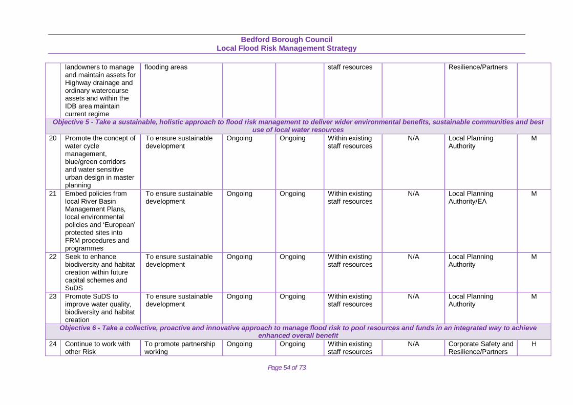
Bedford Borough Council
Local Flood Risk Management Strategy
Page 54 of 73
landowners to manage and maintain assets for Highway drainage and ordinary watercourse assets and within the IDB area maintain current regime
flooding areas staff resources Resilience/Partners
Objective 5 - Take a sustainable, holistic approach to flood risk management to deliver wider environmental benefits, sustainable communities and best use of local water resources
20 Promote the concept of water cycle management, blue/green corridors and water sensitive urban design in master planning
To ensure sustainable development
Ongoing Ongoing Within existing staff resources
N/A Local Planning Authority
M
21 Embed policies from local River Basin Management Plans, local environmental policies and ‘European’ protected sites into FRM procedures and programmes
To ensure sustainable development
Ongoing Ongoing Within existing staff resources
N/A Local Planning Authority/EA
M
22 Seek to enhance biodiversity and habitat creation within future capital schemes and SuDS
To ensure sustainable development
Ongoing Ongoing Within existing staff resources
N/A Local Planning Authority
M
23 Promote SuDS to improve water quality, biodiversity and habitat creation
To ensure sustainable development
Ongoing Ongoing Within existing staff resources
N/A Local Planning Authority
M
Objective 6 - Take a collective, proactive and innovative approach to manage flood risk to pool resources and funds in an integrated way to achieve enhanced overall benefit
24 Continue to work with other Risk
To promote partnership working
Ongoing Ongoing Within existing staff resources
N/A Corporate Safety and Resilience/Partners
H
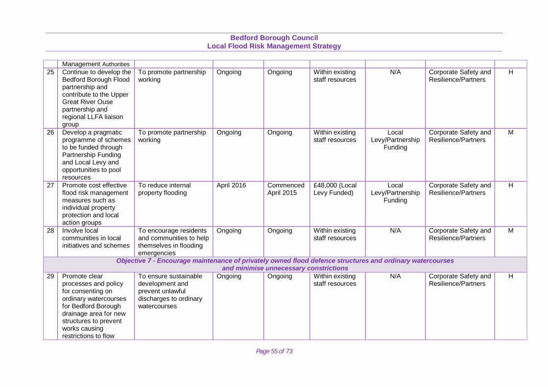
Bedford Borough Council
Local Flood Risk Management Strategy
Page 55 of 73
Management Authorities 25 Continue to develop the
Bedford Borough Flood partnership and contribute to the Upper Great River Ouse partnership and regional LLFA liaison group
To promote partnership working
Ongoing Ongoing Within existing staff resources
N/A Corporate Safety and Resilience/Partners
H
26 Develop a pragmatic programme of schemes to be funded through Partnership Funding and Local Levy and opportunities to pool resources
To promote partnership working
Ongoing Ongoing Within existing staff resources
Local Levy/Partnership
Funding
Corporate Safety and Resilience/Partners
M
27 Promote cost effective flood risk management measures such as individual property protection and local action groups
To reduce internal property flooding
April 2016 Commenced April 2015
£48,000 (Local Levy Funded)
Local Levy/Partnership
Funding
Corporate Safety and Resilience/Partners
H
28 Involve local communities in local initiatives and schemes
To encourage residents and communities to help themselves in flooding emergencies
Ongoing Ongoing Within existing staff resources
N/A Corporate Safety and Resilience/Partners
M
Objective 7 - Encourage maintenance of privately owned flood defence structures and ordinary watercourses and minimise unnecessary constrictions
29 Promote clear processes and policy for consenting on ordinary watercourses for Bedford Borough drainage area for new structures to prevent works causing restrictions to flow
To ensure sustainable development and prevent unlawful discharges to ordinary watercourses
Ongoing Ongoing Within existing staff resources
N/A Corporate Safety and Resilience/Partners
H
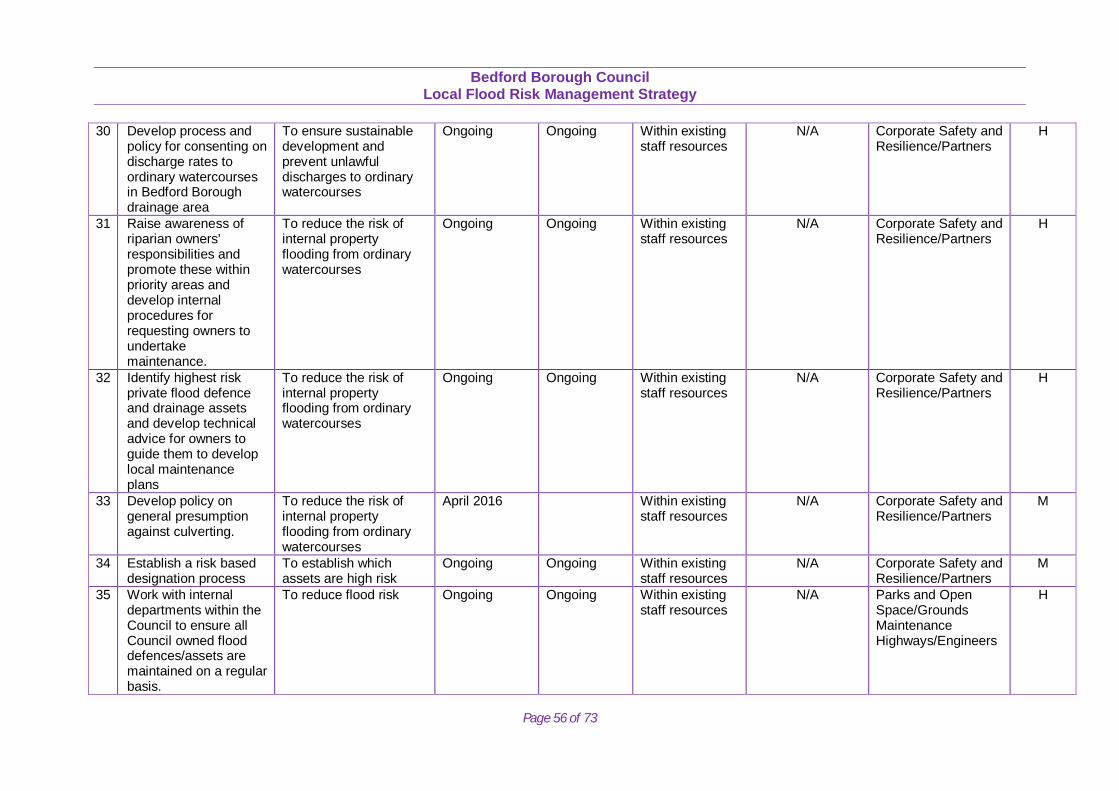
Bedford Borough Council
Local Flood Risk Management Strategy
Page 56 of 73
30 Develop process and policy for consenting on discharge rates to ordinary watercourses in Bedford Borough drainage area
To ensure sustainable development and prevent unlawful discharges to ordinary watercourses
Ongoing Ongoing Within existing staff resources
N/A Corporate Safety and Resilience/Partners
H
31 Raise awareness of riparian owners’ responsibilities and promote these within priority areas and develop internal procedures for requesting owners to undertake maintenance.
To reduce the risk of internal property flooding from ordinary watercourses
Ongoing Ongoing Within existing staff resources
N/A Corporate Safety and Resilience/Partners
H
32 Identify highest risk private flood defence and drainage assets and develop technical advice for owners to guide them to develop local maintenance plans
To reduce the risk of internal property flooding from ordinary watercourses
Ongoing Ongoing Within existing staff resources
N/A Corporate Safety and Resilience/Partners
H
33 Develop policy on general presumption against culverting.
To reduce the risk of internal property flooding from ordinary watercourses
April 2016 Within existing staff resources
N/A Corporate Safety and Resilience/Partners
M
34 Establish a risk based designation process
To establish which assets are high risk
Ongoing Ongoing Within existing staff resources
N/A Corporate Safety and Resilience/Partners
M
35 Work with internal departments within the Council to ensure all Council owned flood defences/assets are maintained on a regular basis.
To reduce flood risk Ongoing Ongoing Within existing staff resources
N/A Parks and Open Space/Grounds Maintenance Highways/Engineers
H
Bedford Borough Council
Local Flood Risk Management Strategy
Page 57 of 73
7.0 CONCLUSIONS AND RECOMMENDATIONS The LFRMS aims to promote objectives that deliver sustainable flood risk management. It is an important tool to protect vulnerable communities and deliver sustainable regeneration and growth. As expected of a strategy for managing flood risk, the majority of measures within the strategy will contribute to the achievement reducing flood risk to people, property and infrastructure. As a result the strategy is likely to have a significant positive effect on reducing flood risk to local communities. A range of different strategy options for delivering the LFRMS have been assessed through the SEA. These alternatives include the:
‘do nothing’ scenario, where no action is taken and existing assets and ordinary watercourses are abandoned. ‘maintain current flood risk’ as a scenario, where existing assets and watercourses are maintained at present in line with current levels
of flood risk. ‘manage and reduce local flood risk’, where flood risk management initiatives are designed and implemented to have a positive effect
on reducing flood risk. This has the potential to provide a range of environmental benefits and offers a pro-active approach to managing flood risk.
To manage and reduce local flood risk is the approach that Bedford Borough Council will take with regard to local flood risk management. Flood risk management initiatives, if designed and implemented in an appropriate manner, could have multiple benefits. This could include reducing flood risk to people and property, contributing to the protection of heritage assets and improvements in water quality, and providing new opportunities for habitat creation and the provision of recreation and amenity assets. Conversely, flood risk management measures, if implemented in an inappropriate manner, could result in adverse effects on a range of environmental features. However, with the risk being managed through the LFRMS and through the planning and consenting process, the risks can be effectively managed for the Borough. The recommendations from this LFRMS will be to seek to maximise the potential environmental benefits associated with delivery of the Action Plan and implement all the measures identified within the Action Plan in the most effective way through the integration of LFRMS objectives and through close partnership working, so that appropriate resources and funding are effectively allocated. The LFRMS will seek to manage and reduce local flood risk within the Borough.
Bedford Borough Council
Local Flood Risk Management Strategy
Page 58 of 73
8.0. REVIEW OF THE STRATEGY The Borough Council has a duty to maintain and monitor the strategy. The Strategy provides a high level framework for the Council’s delivery of its flood risk responsibilities. The Strategy will be monitored by officers of the Bedford Borough Flood Partnership meetings. Progress against the measures will be reported to the Head of Regulatory Services on an annual basis and through annual service planning and performance reviews. The strategy has been developed to deliver a short to medium term improvement plan to establish a sound evidence and knowledge base. The responsibility for maintenance, review and updating of the Strategy and provision of an annual progress report will be the responsibility of the Senior Flood Risk Officer.
• Review the main strategy document every five years, and update as appropriate. • Review the annexes annually and update as appropriate. • Review and update the Action Plan annually.
Updates may be more frequent. The following may prompt a more frequent review:
• Legislation changes that may result in changes to policy, which could affect roles and responsibilities. • Alterations to the understanding or nature of local flood risk. • A significant flood event.
9.0. A SUSTAINABLE APPROACH The LFRMS provides a delivery vehicle for improved flood risk management and supports the development of partnership funding and a strategic investment programme. It will provide considerable opportunities to improve and integrate land use planning and flood risk management. It is an important tool to protect vulnerable communities and deliver sustainable regeneration and growth. It seeks to maximise the potential environmental benefits associated with delivery of these objectives/measures. This can be best achieved through the integration of LFRMS objectives and through close partnership working, so that appropriate resources and funding are effectively allocated. It is essential that risk management authorities work together to achieve the functions set out in recent legislation. Effective sharing of information between risk management authorities can go a long way towards this aim.
Bedford Borough Council
Local Flood Risk Management Strategy
Page 59 of 73
The strategy provides opportunities to improve some aspects of the Borough’s environment, and is expected to contribute towards the wider goal of sustainable development. The adoption of a holistic approach to flood risk management has the potential to enable communities to adapt to the possible implications of climate change, to enhance the natural environment, and in certain circumstances promote biodiversity. Our more holistic and integrated approach to flood risk management should help us to mitigate and adapt to the potential impacts of climate change. 10.0 NEXT STEPS Progress has been made in considering the links between different forms of flood risk. Studies such as surface water management plans consider the interaction between surface water and sewage flooding. Joint work on strategic flood risk assessments and developing joint funding bids across neighbouring authorities will ensure that all flood risks within a catchment are taken into account. The duty to cooperate is leading to much closer working between risk management authorities. Discussion at the partnership meetings ensures that the new and developing information on surface water flood risk is considered alongside the range of information that exists on fluvial risk throughout the Borough. This strategic overview will be vital in developing the annual programme of bids for national funding, which may be foe fluvial or surface water schemes. The actions demonstrate how work to reduce local flood risk will be integrated with other types of flood risk, including fluvial flood risk providing a holistic and sustainable approach to flood risk management. However, our knowledge and understanding on surface water and groundwater flood risk will improve significantly in the coming years. There must be opportunities to update the strategy as new information becomes available. For this reason the strategy should be viewed as a ‘living document’.
Bedford Borough Council
Local Flood Risk Management Strategy
Page 60 of 73
TECHNICAL APPENDICES
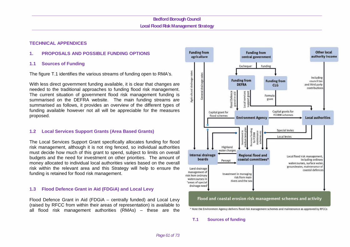
Bedford Borough Council
Local Flood Risk Management Strategy
Page 61 of 73
TECHNICAL APPENDICES
1. PROPOSALS AND POSSIBLE FUNDING OPTIONS
1.1 Sources of Funding
The figure T.1 identifies the various streams of funding open to RMA’s.
With less direct government funding available, it is clear that changes are needed to the traditional approaches to funding flood risk management. The current situation of government flood risk management funding is summarised on the DEFRA website. The main funding streams are summarised as follows, it provides an overview of the different types of funding available however not all will be appreciable for the measures proposed. 1.2 Local Services Support Grants (Area Based Grants) The Local Services Support Grant specifically allocates funding for flood risk management, although it is not ring fenced, so individual authorities must decide how much of this grant to spend, subject to limits on overall budgets and the need for investment on other priorities. The amount of money allocated to individual local authorities varies based on the overall risk within the relevant area and this Strategy will help to ensure the funding is retained for flood risk management. 1.3 Flood Defence Grant in Aid (FDGiA) and Local Levy Flood Defence Grant in Aid (FDGiA – centrally funded) and Local Levy (raised by RFCC from within their areas of representation) is available to all flood risk management authorities (RMAs) – these are the
T.1 Sources of funding
Bedford Borough Council
Local Flood Risk Management Strategy
Page 62 of 73
Environment Agency and English Local Authorities and internal drainage boards (IDBs). Together they use it to pay for a range of activities including flood defence schemes that help reduce the risk of flooding and coastal erosion. The DEFRA policy on Flood and Coastal Resilience Partnership Funding governs the allocation of funds under the FDGiA / Local Levy process. Instead of meeting the full costs of just a limited number of projects, the approach makes Government money available towards any worthwhile scheme over time. Regional Flood and Coastal Committees (RFCCs) play an important role in agreeing programmes of work and can raise extra funding from local authorities, known as Local Levy. Funding levels for each scheme will relate directly to the number of households protected, the damages being prevented, plus the other benefits a scheme would deliver (‘outcomes based approach’). The figure below demonstrates how this approach works. Grants for surface water management and property-level protection are available alongside funding for other risks and approaches. Some schemes will be fully funded, others only partly funded by FDGiA, according to how much public benefit they will give, for example by reducing flood risk to homes and vital infrastructure, such as power stations and water treatment works. There are always more schemes proposed than there is government funding available in any one year. Any shortfall in the amount of central government funding will need to be found from elsewhere. This could be from Local Levy funding from RFCCs, or from local businesses or other parties who will benefit from the scheme. 1.4 Local Funding – Community Infrastructure Levy Community Infrastructure Levy (CIL) is a new 'tariff' style charge which local authorities in England and Wales are empowered, but not required, to charge on all new houses (and other buildings / extensions to buildings of more than 100m2), to be spent on local and sub-regional infrastructure to support the development of the area. Key to obtaining funding towards flood risk schemes from this source will be proactive infrastructure planning through the Infrastructure Delivery Plan (IDP) process. This provides a high level summary of anticipated major infrastructure funding requirements that the Council will be seeking to fund partially or fully through CIL, and schemes which are included in the IDP will be more likely to obtain CIL contributions. It is important to note that CIL will be in high demand across a wide range of infrastructure proposals and therefore it is anticipated that existing mainstream funding will continue to bear the main burden for infrastructure delivery. The New Homes Bonus match funds the additional council tax raised for new homes and properties brought back into use, with an additional amount for affordable homes. It is intended to remove the disincentive to development posed by increased strain on public services and reduced amenities by providing local authorities with the means to mitigate the strain the increased population causes. This income is not ring-fenced so its allocation within a local authority will depend upon local
Bedford Borough Council
Local Flood Risk Management Strategy
Page 63 of 73
priorities. To access this funding source flood risk management measures would need to demonstrate that they meet a number of local priorities, as demand is likely to be extremely high. 1.5 European Union Funding – Regional Development Fund EU funding is a complex and specialist field. Some authorities have invested proactively in this area of fundraising and are experienced in obtaining funds through this route; for example Cornwall and the Isles of Scilly prepared a detailed evidence base to bid for Convergence status in 2005 and thereby gained access to funding through this European economic regeneration programme. Funding from the EU generally needs to be for projects which are innovative. Applicants need to be in a partnership that includes at least four other projects spread across the EU and they need to demonstrate the transference of learning across the areas. Grants tend to be in the region of a few million pounds spread across all participants. The administrative burden on the main applicant can be considerable and needs to be considered when budgeting for EU fundraising. 1.6 Private Funding – Developer Contributions Section 106 of the Town and Country Planning Act allows a local planning authority, such as Bedford Borough Council, to enter an agreement with a landowner or developer in association with the granting of planning permission. A Section 106 agreement is used to address issues that are necessary to make a development acceptable, such as supporting the provision of services and infrastructure. One of the recommendations of ‘Making Space for Water’ was that local planning authorities should make more use of Section 106 agreements to ensure that there is a strong planning policy to manage flood risk. This means that any flood risk which is caused by, or increased by, new development should be resolved and funded by the developer. The Marston Vale Surface Waters Plan also seeks to encourage and promote the use of existing legislation such as S106 to put in place agreements to secure drainage infrastructure for development, which includes the construction and maintenance of strategic SuDS and associated funding.
Bedford Borough Council
Local Flood Risk Management Strategy
Page 64 of 73
1.7 Private Funding – Water Companies Water companies invest money in flood alleviation schemes as part of their duties to remove properties from the DG5 register. Sometimes the most effective way to do this is to work in partnership with risk management authorities on flood alleviation schemes in other areas which can help reduce surface water pressure downstream. Water companies are able to raise funds for flood alleviation schemes through the prices they charge their customers. However these prices are heavily regulated by OfWAT. When determining price limits OfWAT determines how much water companies can charge its customers to: finance its day to day spending finance its capital investment programme reward outperformance in the previous five-year period continue to finance previous capital investment through the return the company earns on its regulatory capital value (RCV) pay tax for which it is liable 1.8 Business Rate Supplements Business rate supplements can be used for flood risk management. Local businesses would need to vote for an increase of up to 2p on local business rates and the funding would need to be used for specified works. Any such proposals would need to be subject to detailed consultation and analysis prior to being utilised. 1.9 Council Tax Flood risk management budgets are very small and significant funds could be raised for flood risk management for a minuscule increase relating to a fraction of 1%. Funds raised through taxation of local householders can give a ‘ring-fenced’ provision within the annual council tax for the specific purpose of addressing flood risk management. An increase would will be subject to a requirement to hold a referendum.
Bedford Borough Council
Local Flood Risk Management Strategy
Page 65 of 73
1.10 Council Capital Funding The Council’s infrastructure programme prioritising capital improvement projects. The programme has included funding for drainage capacity improvements for a number of years which is targeted at the highway drainage systems. 1.11 Council Revenue Funding The Council has a number of revenue streams to support technical and admin processes and to maintain council infrastructure. Existing revenue budgets include Highway Drainage Maintenance, Highway Gully Maintenance and funding for the Resilience Team discharging the LLFA duty for the Council. 1.12 Local Fundraising Another important funding mechanism could come from local fundraising from the local communities and businesses that stand to benefit from the proposed flood defence schemes. Fundraising may appear to be a daunting task but the best place to start is with those who stand to benefit most from the project.
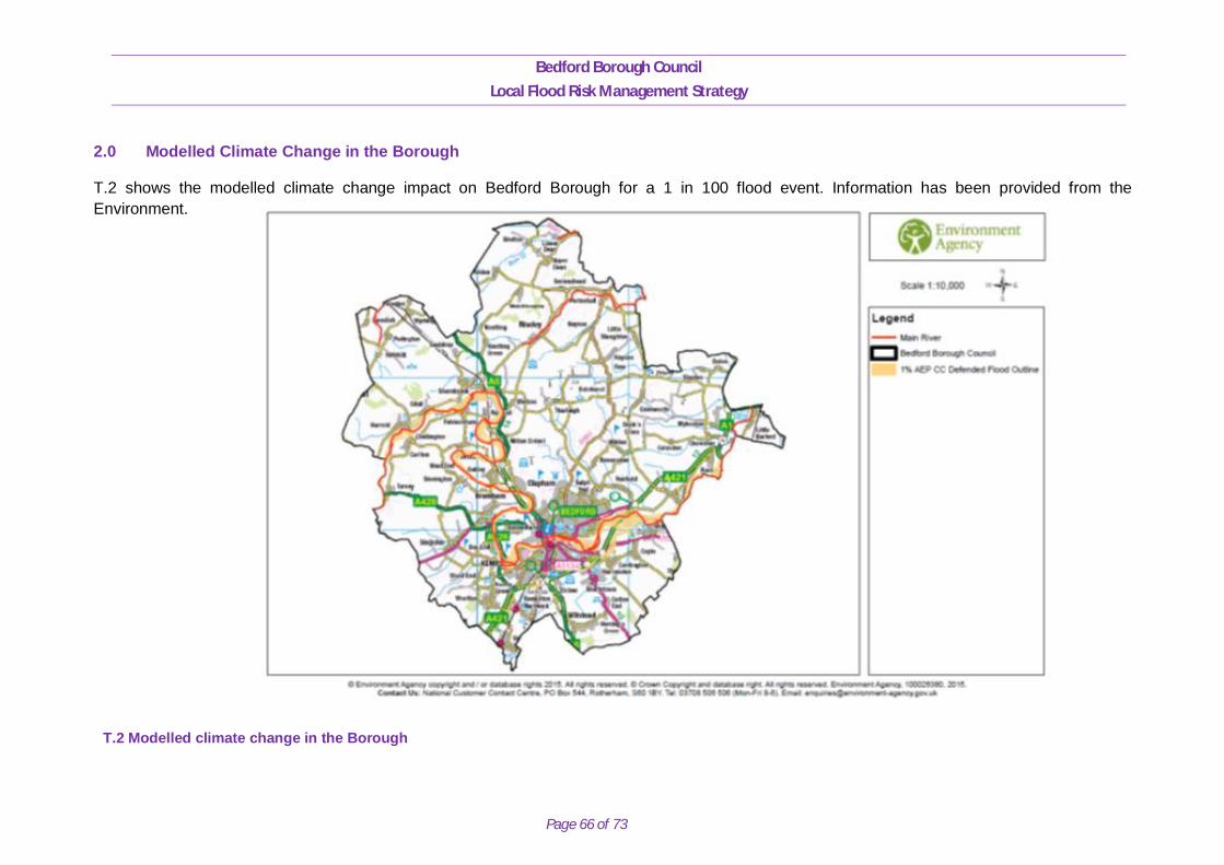
Bedford Borough Council
Local Flood Risk Management Strategy
Page 66 of 73
2.0 Modelled Climate Change in the Borough
T.2 shows the modelled climate change impact on Bedford Borough for a 1 in 100 flood event. Information has been provided from the Environment.
T.2 Modelled climate change in the Borough
Bedford Borough Council
Local Flood Risk Management Strategy
Page 67 of 73
3.0 STRATEGIC ENVIRONMENTAL ASSESSMENT
3.1 Strategic Environmental Assessment (SEA)
SEA is a statutory assessment process required under European Directive 2001/42/EC on the assessment of the effects of certain plans and programmes on the environment (the ‘SEA Directive’). The Directive requires formal assessment of plans and programmes that are likely to have significant effects (either positive or negative) on the environment. It applies to all plans and programmes which are ‘subject to preparation and/or adoption by an authority at national, regional or local level’ or are ‘required by legislative, regulatory or administrative provision. The requirements of the Directive are transposed into UK law through the SEA Regulations.
Local Government Association (LGA) guidance on the production of LFRMS’s identifies the likely requirement for an SEA, stating that ‘the Local [Flood Risk Management] FRM Strategy is likely to require statutory SEA, but this requirement is something the LLFA must consider’. A SEA screening process was therefore undertaken and the Council has confirmed the requirement for its LFRMS to undergo SEA.
SEA involves the systematic identification and evaluation of the potential environmental impacts of the LFRMS. This information is then used to aid the selection of a preferred option(s) for the strategy, which are those that best meet its economic, environmental and social objectives, and legal requirements.
The full range of environmental receptors has been considered through the SEA. This meets the requirements of the SEA Directive, which requires that an assessment identifies the potentially significant environmental impacts on ‘biodiversity, population, human health, fauna, flora, soil, water, air, climatic, material assets including architectural and archaeological heritage, landscape and the interrelationship between the above factors’. The assessment indicates that the ‘do nothing’ approach is likely to result in a number of significant adverse impacts, particularly due to increased flood risk to people and property, and effects on other environmental assets including water quality, historic sites and biodiversity, where increased flooding may create new pathways for the spread of invasive non-native species. These impacts would be likely to increase over time as responsible bodies will be unable to incorporate precautionary measures in existing or new developments in a response to climate change pressures. Conversely, increased flood risk may result in greater connectivity between watercourses and their floodplains, offering opportunities for habitat creation/enhancement of benefit to a range of protected and notable species.
The option to ‘maintain current flood risk’ is likely to result in little or no additional impact on the environment in the short to medium term as the existing flood risk management regime continues to maintain existing levels of flood protection. However, in the future, as a result of climate
Bedford Borough Council
Local Flood Risk Management Strategy
Page 68 of 73
change, flood risk will increase, resulting in many of the impacts identified under the ‘do nothing’ scenario, although potentially to a lesser extent and significance.
Therefore, to ‘manage and reduce local flood risk’ is the only realistic approach to be employed by Bedford Borough Council as it has the potential to provide a range of environmental benefits and offers a pro-active approach to managing flood risk.
The SEA for Bedford Borough Council’s Strategy has been completed as a standalone study and is available on the Council’s website for reference purposes.
3.2 Strategy Alternatives
3.2.1 Developing alternatives
The SEA Directive requires an assessment of the plan and its 'reasonable alternatives'. In order to assess reasonable alternatives, different strategy options for delivering the LFRMS have been assessed at a strategic level against the SEA objectives, and the environmental baseline. The results of this assessment will be used to inform the decision-making process in choosing a preferred way of delivering the LFRMS.
3.2.2 Appraisal of actions to improve flood risk
The LFRMS has the purpose of managing and reducing local flood risk in Bedford Borough. The strategy objectives have been assessed against the SEA objectives for each of the following options.
1. Do nothing: where no action is taken and existing assets and ordinary watercourses are abandoned. 2. Maintain current flood risk management regime: where existing assets and watercourses are maintained as present in line with current levels of flood risk. Existing infrastructure is not improved over time and the effects of climate change are not taken into account; and 3. Manage and reduce local flood risk: take action to reduce the social, economic and environmental impact due to flooding.
Bedford Borough Council
Local Flood Risk Management Strategy
Page 69 of 73
Option 1 (do nothing) is likely to result in a number of significant adverse impacts, particularly in relation to people and property, and other environmental assets including historic sites and biodiversity, where increased flooding may create new pathways for the spread of invasive non-native species. Surface water and groundwater quality could also be adversely affected, with increased flooding of contaminated sites leading to greater impacts on water resources. Conversely, increased flood risk may result in greater connectivity between watercourse and their floodplains, offering opportunities for habitat creation of benefit to a range of protected and notable species.
Option 2 (maintain current flood risk management regime) is likely to result in little or no change in the environmental baseline in the short to medium term as the existing flood risk management regime continues to maintain existing levels of flood protection. However, in the future, as a result of climate change, flood risk will increase, resulting in many of the impacts identified under Option 1, although potentially to a lesser extent and significance.
Option 3 (manage and reduce local flood risk) has the potential to provide a range of environmental benefits. Flood risk management initiatives, if designed and implemented in an appropriate manner, could have multiple benefits. This could include reducing flood risk to people and property, contributing to the protection of heritage assets and improvements in water quality, and providing new opportunities for habitat creation and the provision of recreation and amenity assets. Conversely, flood risk management measures, if implemented in an inappropriate manner, could result in adverse effects on a range of environmental features. However, this risk is managed through the preparation of the SEA and through the planning and consenting process, which is likely to require consideration of the sustainability of a project prior to its implementation. Therefore, it is evident that by doing nothing or maintaining current levels of management, there are likely to be detrimental effects on the SEA objectives, which are likely to be prevented by carrying out active flood risk management as proposed by the LFRMS.
The Objectives and measures developed can be viewed within the SEA. Option 3 is the only realistic approach to be employed by Bedford Borough Council as it has the potential to provide a range of environmental benefits and offers a pro-active approach to managing flood risk.
Bedford Borough Council Local Flood Risk Management Strategy
Page 70 of 73
4.0 Glossary of Terms
Annual Exceedance Probability (AEP) Aquifer Attenuation
The chance of a flood of a given size happening in any one year e.g. An underground layer of water-bearing permeable material from which groundwater can be extracted. The reduction in intensity and duration of water flow.
BLRF Bedfordshire Local Emergency Forum Catchment
A surface water catchment in the total area that drains into a river or other drainage system
Catchment Flood Management Plan (CFMP) Channel Culvert
A strategic planning tool through which the Environment Agency works with other key decision makers within a river catchment to identify and agree policies for sustainable flood risk management The physical confine of a watercourse Channel to transport water underneath artificial construction such as road, railway or embankment
Climate Change
A long term change in weather patterns. In the context of flood risk, climate change will produce more frequent and more severe rainfall events.
Critical Infrastructure
Infrastructure which is considered vital or indispensable to society, the economy, public health or the environment, and where the failure or destruction would have large impact. This would include emergency services such as hospitals, schools, communications, electricity sub-stations, water and waste water treatment works, transport infrastructure and reservoirs.
Department for Environment, Food and Rural Affairs (Defra)
The UK government department responsible for policy and regulations on the environment, food and rural affairs.
Bedford Borough Council
Local Flood Risk Management Strategy
Page 71 of 73
DG5 Register Discharge Ditch
A Water and Sewerage Company (WaSC) held register of properties which have experienced sewer flooding (either internal or external) due to hydraulic overload, or properties which are ‘at risk’ of sewer flooding more frequently than once in 20 years. The rate of water flow. A small to moderate artificial depression to transport water.
Environment Agency
An Executive Non-departmental Public Body responsible to the Secretary of State for environment, Food and Rural Affairs and an Assembly Sponsored Public Body responsible to the National Assembly for Wales. The Environment Agency’s principal aims are to protect and improve the environment, and to promote sustainable development. They play a central role in delivering the environmental priorities of central government and the Welsh Assembly Government through our functions and roles. The Environment Agency has permissive powers to carry out works of maintenance and improvement on Main Rivers. This can include any structure or appliance for controlling or regulating flow of water into or out of the channel. The overall responsibility for maintenance of Main Rivers, however, lies with the riparian owner.
Exceedance Flows
Excess flow that appears on the surface once the capacity of the underground drainage system is exceeded.
FMfSW
A Flood Map for Surface Water Deep = 0.3m deep flooding Shallow = 0.1m deep flooding
Flood Risk Management Plan
A plan for the management of a significant flood risk. The plan must include details of: objectives set by the person preparing the plan for the purpose of managing the flood risk; and the proposed measures for achieving those objectives (including measures required by any provision of an Act or subordinate legislation).
Flood Zones
Nationally consistent delineation of ‘high’ and ‘medium’ flood risk from fluvial flooding,
Bedford Borough Council
Local Flood Risk Management Strategy
Page 72 of 73
published on a quarterly basis by the Environment Agency. Flood Zone 1
Areas with the lowest probability of flooding from rivers and the sea, where the chance of flooding in any one year is less than 0.1% (i.e. a 1000 to 1 chance)
Flood Zone 2
Areas with the chance of flooding in any one year between 0.1% and 1% fluvial or 0.5% tidal (i.e. between a 1000 to 1 and a 100 to 1 fluvial or 200 to 1 tidal chance).
Flood Zone 3
Areas with the highest probability of flooding. The chance of flooding in any one year is greater than or equal to 1% (i.e. a 100 to 1 chance) for river flooding and greater or equal to 0.5% (i.e. a 200 to 1 chance) for coastal and tidal flooding.
Flood Risk Regulations
Legislation that transposed the European Floods Directive in 2009
Flood and Water Management Act
The Flood and Water Management (2010) clarifies the legislative framework for managing surface water flood risk in England
Floods Directive
The EU Floods Directive came into force in November 2007 and is designed to help Member States prevent and limit the impact of floods on people, property and the environment. It was transposed into English law in December 2009 by the Flood Risk Regulations.
Fluvial Flooding
Occurs when water levels in a channel overwhelms the capacity of the channel.
Internal Drainage Board (IDB) A consortium of statutory bodies providing local storm water management by undertaking watercourse maintenance and improvement, adoption and maintenance of Sustainable Drainage Systems (SuDs) and provision of advice and direction to local authorities and developers as part of the Town and Country planning procedure
Lead Local Flood Authority (LLFA) Under the Flood and Water Management Act (2010) Bedford Borough Council is now a 'Lead Local Flood Authority' with improved responsibilities for local flood risk management.
Main River Water courses shown on the statutory main river map (held by the EA and Defra)
Bedford Borough Council
Local Flood Risk Management Strategy
Page 73 of 73
Ordinary Watercourse Any watercourse (including ditches and streams) that is not identified as main rivers on Defra’s register.
Pluvial Flooding Pluvial (surface water flooding due to intense rainfall) Occurs when rainfall cannot absorb into the ground (due to saturated soil or hard surfaces such as tarmac) or when the amount falling exceeds the capacity of the drainage network to take it away, causing it to flow across the ground.
Riparian Owners A person that owns land adjoining a watercourse. SuDS
Sustainable Drainage Systems. SuDS are drainage systems which are designed to reduce the impact of urbanisation on the hydrology of a river system.
Surface Water Flooding Rainwater (including snow and other precipitation) which: is on the surface of the ground (whether or not it is moving); and has not entered a watercourse, draining system or public sewer.
SWMP
Surface Water Management Plan
Sustainable Development
“Development that meets the needs of the present without compromising the ability of future generations to meet their own needs” (The World Commission on Environment and Development, 1987)
Water Framework Directive (WFD)
Is a European Union directive which commits European Union member states to achieve good qualitative and quantitative status of all water bodies by 2015.